Sheetlines. The journal of THE CHARLES CLOSE SOCIETY for the Study of Ordnance Survey Maps. Colby s camps Iain Thornber and Richard Oliver
|
|
|
- Bernard Cox
- 5 years ago
- Views:
Transcription
1 Sheetlines The journal of THE CHARLES CLOSE SOCIETY for the Study of Ordnance Survey Maps Colby s camps Iain Thornber and Richard Oliver Sheetlines, 90 (April 2011), pp Stable URL: This article is provided for personal, non-commercial use only. Please contact the Society regarding any other use of this work. Published by THE CHARLES CLOSE SOCIETY for the Study of Ordnance Survey Maps The Charles Close Society was founded in 1980 to bring together all those with an interest in the maps and history of the Ordnance Survey of Great Britain and its counterparts in the island of Ireland. The Society takes its name from Colonel Sir Charles Arden-Close, OS Director General from 1911 to 1922, and initiator of many of the maps now sought after by collectors. The Society publishes a wide range of books and booklets on historic OS map series and its journal, Sheetlines, is recognised internationally for its specialist articles on Ordnance Survey-related topics.
.")


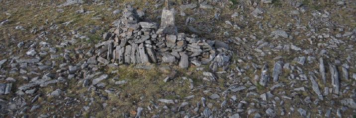
2 18 Colby s camps Iain Thornber and Richard Oliver The camp on Creach Bheinn, Ardgour (NM ). Visible are the two massive stone wall windbreaks, between which are four semicircular stone platforms, possibly bases for tented accommodation and a more substantial building near the lower wall, possibly the cook house or officer accommodation. It is well known that the Ordnance Survey had its origins in a late eighteenth century project to construct a triangulation of Great Britain, starting with a base line at Hounslow Heath. By 1809 most of England had been triangulated, and work was under way in southern Scotland. By 1822 a large part of Scotland had

3 19 been observed, and a connection had been established to the north of Ireland. The ensuing six-inch scale Townland survey of Ireland and a greatly increased use in triangulation for control of detail meant that from 1824 to 1837 all Ordnance trigonometrical work was concentrated in that country. When the triangulation of Britain was resumed in 1838 much of the earlier work was felt to be unsound and was re-observed, together with observations of some stations not previously occupied. The fieldwork was completed in 1852, and the results were published in Because of the extensive work after 1838, much of the later observing can only have had a very tenuous connection with Thomas Colby. Up the late 1820s he had participated personally in the observations in the field, and expected to be away from Survey headquarters Creach Bheinn, detail of lower in the Tower or at Dublin for long windbreak wall periods in the observing season, but thereafter he was much more desk-bound. No complete list survives of which station was occupied when, but it is evident that the concept of primary, secondary and tertiary orders of triangulation only emerged gradually. Whilst none of the stations observed in Britain before 1824 was of tertiary status, many were later of only secondary status. Of the stations shown in these photographs, most were not treated as primary stations when the work came to be computed and written up by Alexander Ross Clarke in the 1850s.1 In fact, the only one that was is that on Jura, presumably first occupied in 1822 at least partly with a view to the connection with Ireland. The most striking group of the photos is of Creach Beinn (NM ), which was evidently treated as a secondary station by Clarke s time. In fact, it is unclear whether Colby himself actually occupied it. The foundations for tents are interesting relics: one wonders if they might have been reused or even repaired by visitors later. 1 A R Clarke, Account of the observations and calculations of the principal triangulation, Southampton: Ordnance Survey, 1858: a summary of the work and a diagram of the primary triangulation is in W A Seymour (ed), A history of the Ordnance Survey, Folkestone: Dawson, 1980, 33-43, , and Plate 11.


4 20 Beinn an Oir, Jura (NR ) above: camp and path leading to summit cairn; below left: the camp; below right: unrecorded stone building about 100 metres below and east of summit, possibly WC or observation hut Opposite: Top and middle: trig point and remains of camp on Ben Alder (NN ) Lower: original trig point on island of Staffa, above and to the left of McKinnon s Cave (by the boat)


5 21 4
6 22 Colby and others chose stations for their good inter-visibility with other stations, and this meant that it was inevitable that they would be on the summits of hills and mountains, and thus often in rather inhospitable places. The usual way of marking the observing stations was by buried stones, about two feet or so square, with a hole bored to indicate the precise point for setting up the theodolite: on mountains it was usual to protect these stones by erecting cairns over them. Although a considerable achievement in its day, the triangulation did not compare well with later European ones, even by 1900, and much of the secondary triangulation had been undertaken to suit county-based rather than nationally-based larger-scale survey. Thus a complete re-triangulation began in 1935: most of the primary observations were completed by 1938, but the results were only published in Many of the original stations were reoccupied, but now they were marked by concrete pillars, and the building of these tended to result in the partial demolition of the original cairns. Some summits, such as Creach Beinn, which had not been used as primary stations in the original triangulation were now promoted to that status: it would be interesting to know whether any of the camps of the earlier nineteenth century were reused a hundred or more years later.2 Photographs and captions are by Iain Thornber (left), narrative is by Richard Oliver. Iain Thornber, JP, DL, FSA has written extensively on aspects of Scottish history and archaeology. His recreations are deer stalking, photography and local history research. 2 The history of the retriangulation of Great Britain, 2 vols, London: HMSO, 1967: summarised in Seymour (ed), A history, , , and Plate 18.
Sheetlines. The journal of THE CHARLES CLOSE SOCIETY for the Study of Ordnance Survey Maps. Surveying the surveyors Keith D Lilley
 Sheetlines The journal of THE CHARLES CLOSE SOCIETY for the Study of Ordnance Survey Maps Surveying the surveyors Keith D Lilley Sheetlines, 113 (December 2018), pp6-12 Stable URL: https://s3.eu-west-2.amazonaws.com/sheetlinesarticles/issue113page6.pdf
Sheetlines. The journal of THE CHARLES CLOSE SOCIETY for the Study of Ordnance Survey Maps. Mere questions Michael Spencer
 Sheetlines The journal of THE CHARLES CLOSE SOCIETY for the Study of Ordnance Survey Maps Mere questions Michael Spencer Sheetlines, 110 (December 2017), pp14-17 Stable URL: https://s3.eu-west-2.amazonaws.com/sheetlinesarticles/issue110page14.pdf
Sheetlines. The journal of THE CHARLES CLOSE SOCIETY for the Study of Ordnance Survey Maps
 Sheetlines The journal of THE CHARLES CLOSE SOCIETY for the Study of Ordnance Survey Maps This edition of Sheetlines was published in 2011 and the articles may have been superseded by later research. Please
Sheetlines. The journal of THE CHARLES CLOSE SOCIETY for the Study of Ordnance Survey Maps. Khrushchev preferred Bartholomew's maps John L Cruickshank
 Sheetlines The journal of THE CHARLES CLOSE SOCIETY for the Study of Ordnance Survey Maps Khrushchev preferred Bartholomew's maps John L Cruickshank Sheetlines, 87 (April 2010), pp.31-34 Stable URL: http://www.charlesclosesociety.org/files/issue87page31.pdf
GeomaticsWorld. Issue No 4 : Volume 20. Surveying for geographical and spatial information in the 21st century
 GeomaticsWorld MAY JUNE 2012 Issue No 4 : Volume 20 Surveying for geographical and spatial information in the 21st century Repairing New Zealand s shaken cadastra Can 19th c. mapping help in retracing
Map Name(s) and Date(s) Historical Map - Segment A13. Order Details Order Number: Customer Ref:
 and Date(s) Historical Map - Segment A13. Order Details Order Number: Customer Ref:") Published 1975-1989 Source map scale - 1:1,250 The historical maps shown were reproduced from maps predominantly held at the scale adopted for England, Wales and Scotland in the 1840`s. In 1854 the 1:2,500
Published 1975-1989 Source map scale - 1:1,250 The historical maps shown were reproduced from maps predominantly held at the scale adopted for England, Wales and Scotland in the 1840`s. In 1854 the 1:2,500
Sheetlines. The journal of THE CHARLES CLOSE SOCIETY for the Study of Ordnance Survey Maps. The Auto-Mapic map of GB Thomas O Loughlin
 Sheetlines The journal of THE CHARLES CLOSE SOCIETY for the Study of Ordnance Survey Maps The Auto-Mapic map of GB Thomas O Loughlin Sheetlines, 104 (December 2015), pp30-34 Stable URL: http://www.charlesclosesociety.org/files/issue104page30.pdf
Our Lady Immaculate Catholic Primary School History and Geography Curriculum Map Would the Bog Baby survive in Liverpool?
 Year 1 and 2 - *Year 1 and 2 work on a two year cycle due to mixed classes Autumn 1 National Curriculum link: Human and physical geography - identify seasonal and daily weather patterns in the United Kingdom
Geography Long Term Plan 2018
 Geography Long Term Plan 2018 Geography Co-ordinator: Megan Frost A high-quality geography education should inspire in pupils a curiosity and fascination about the world and its people that will remain
MEADOWS PRIMARY SCHOOL and NURSERY GEOGRAPHY POLICY
 MEADOWS PRIMARY SCHOOL and NURSERY GEOGRAPHY POLICY Purpose of study The teaching of Geography at Meadows is done by following the 2014 National Curriculum. The planning and teaching of the subject aims
BLACK PEAR TRUST SUBJECT PLAN - GEOGRAPHY
 Purpose of Study A high-quality geography education should inspire in pupils a curiosity and fascination about the world and its people that will remain with them for the rest of their lives. Teaching
Landmarks Paula Owens 5 7 years
 Landmarks Paula Owens Geography teaching resource 5 7 years This is one of a series of teaching resources for use with Digimap for Schools. For more details about this service, visit http://digimapforschools.edina.ac.uk
Map Name(s) and Date(s) Historical Map - Segment A13. Order Details. Site Details 459 Dover Road, Walmer, DEAL, Kent, CT14 7PG. Customer Ref: 28927
 and Date(s) Historical Map - Segment A13. Order Details. Site Details 459 Dover Road, Walmer, DEAL, Kent, CT14 7PG. Customer Ref: 28927") Ordnance Survey Plan Published 1973-1974 Source map scale - 1:1,250 The historical maps shown were reproduced from maps predominantly held at the scale adopted for England, Wales and Scotland in the 1840`s.
Ordnance Survey Plan Published 1973-1974 Source map scale - 1:1,250 The historical maps shown were reproduced from maps predominantly held at the scale adopted for England, Wales and Scotland in the 1840`s.
Sheetlines. The journal of THE CHARLES CLOSE SOCIETY for the Study of Ordnance Survey Maps
 Sheetlines The journal of THE CHARLES CLOSE SOCIETY for the Study of Ordnance Survey Maps Ordnance Survey data collection and mapping of tidal features Brian Baily Sheetlines, 90 (April 2011), pp.4-17
Cambridge International Examinations Cambridge International General Certificate of Secondary Education
 Cambridge International Examinations Cambridge International General Certificate of Secondary Education *5044984413* GEOGRAPHY 0460/22 Paper 2 May/June 2015 Candidates answer on the Question Paper. Additional
Northamptonshire Archaeology
 Northamptonshire Archaeology Archaeological Geophysical Survey At Sulgrave Castle Green, Sulgrave, Northamptonshire August 2007 Adrian Butler November 2007 Report 07/192 Northamptonshire Archaeology 2
Survey of Thack Moor
 Survey of Thack Moor 22 August 2012 The Team: John Barnard, Graham Jackson and Myrddyn Phillips 03 March 2013 The Team: John Barnard, Graham Jackson, Myrddyn Phillips and Bob Smith (Grough) 1) Introduction
Map Name(s) and Date(s) Historical Map - Slice A
 and Date(s) Historical Map - Slice A") VectorMap Local Published 2016 Source map scale - 1:10,000 VectorMap Local (Raster) is Ordnance Survey's highest detailed 'backdrop' mapping product. These maps are produced from OS's VectorMap Local,
VectorMap Local Published 2016 Source map scale - 1:10,000 VectorMap Local (Raster) is Ordnance Survey's highest detailed 'backdrop' mapping product. These maps are produced from OS's VectorMap Local,
. For each problem you must set up equations, draw and label triangles, and answer the question(s) in a complete sentence
 in a complete sentence") Name Trig Tasks For these tasks, you have been hired by World Wide Engineering (WWE) and you will travel around the world to solve real life problems using trigonometry. You will be completing a series
Name Trig Tasks For these tasks, you have been hired by World Wide Engineering (WWE) and you will travel around the world to solve real life problems using trigonometry. You will be completing a series
Year 1 name and locate the four countries and capital cities of the United Kingdom and its surrounding seas
 Long Term Objective Organisation for Geography Please note that only statutory requirements should be included in this document; any supplementary guidance and information should be retained by Subject
181 London Road, Isleworth, London Borough of Hounslow
 181 London Road, Isleworth, London Borough of Hounslow An Archaeological Evaluation for Crest Nicholson Residential (South) Ltd by Jo Pine and Andy Taylor Thames Valley Archaeological Services Ltd Site
Geography Route Planner
 Geography Route Planner Introduction to Route Planners Route Planners outline the Key Stages 1-3 curriculum to be taught within each campus of the Bury St Edmunds Trust. Each Route Planner has been designed
YEAR 7 REVISION BOOKLET
 YEAR 7 REVISION BOOKLET Assessment checklist 1. To be able to define Geography. 2. Give examples of what we study in geography 3. Group what we study into the three major areas of geography 4. To be able
Abbotswood Junior School National Curriculum 2014
 Geography Purpose A high-quality geography education should inspire in pupils a curiosity and fascination about the world and its people that will remain with them for the rest of their lives. Teaching
SEA LIFE Sydney Aquarium. Penguin Expedition Self-Guided Resource Kit. Secondary 7-10
 SEA LIFE Sydney Aquarium Penguin Expedition Self-Guided Resource Kit Secondary 7-10 Introduction The following material has been developed by the SEA LIFE Sydney Aquarium Education Team to support our
THE ARFORDIR COASTAL HERITAGE SITE RECORDING FORM
 THE ARFORDIR COASTAL HERITAGE SITE RECORDING FORM Information to assist with filling in the form Why do we need to use the form? Archaeology is not only about finding things, but about telling others about
GEOGRAPHY POLICY STATEMENT. The study of geography helps our pupils to make sense of the world around them.
 GEOGRAPHY POLICY STATEMENT We believe that the study of geography is concerned with people, place, space and the environment and explores the relationships between the earth and its peoples. The study
Land at Larchwood Farm, Whitehorse Lane Finchampstead, Berkshire
 Land at Larchwood Farm, Whitehorse Lane Finchampstead, Berkshire An Archaeological Evaluation for Mr. John Westbrook by James McNicoll-Norbury Thames Valley Archaeological Services Ltd Site Code LFF08/103
STAG LANE JUNIOR SCHOOL GEOGRAPHY POLICY
 Status-Recommended Prepared by: Megha Visavadia Date written January 2017 Shared with staff: Spring 2017 STAG LANE JUNIOR SCHOOL GEOGRAPHY POLICY Shared with governors: Spring 2018 Date for review: July
Geography. Programmes of study for Key Stages 1-3
 Geography Programmes of study for Key Stages 1-3 February 2013 Contents Purpose of study 3 Aims 3 Attainment targets 3 Subject content 4 Key Stage 1 4 Key Stage 2 5 Key Stage 3 6 2 Purpose of study A high-quality
Range of Opportunities
 Geograhy Curriculum Cropwell Bishop Primary School Range of Opportunities Year 1 Year 2 Year 3 Year 4 Year 5 Year 6 All Key Stage 1 Key Stage 2 Investigate the countries and capitals of the United Kingdom.
Geophysical Investigation of a 19th Century Archeological Site, Boston College K. Corcoran, J. Hager, M. Carnevale
 Geophysical Investigation of a 19th Century Archeological Site, Boston College K. Corcoran, J. Hager, M. Carnevale Hager GeoScience, Inc., Waltham, MA ------------------------------------------------------------------------
name and locate the world s seven continents and five oceans
 Subject: Geography Activities National Curriculum Objectives One Progression of Skills Name the 7 continents and 5 oceans 3D Jigsaw task to locate continents and seas name and locate the world s seven
NATIONAL CURRICULUM GEOGRAPHY PLANNING OVERVIEW
 GEOGRAPHY AUTUMN TERM SPRING TERM SUMMER TERM Year 1 Hunting and Hiding Me and My Wonderful World Beside The Sea identify seasonal and daily weather patterns in the United Kingdom and the location of hot
Sheetlines. The journal of THE CHARLES CLOSE SOCIETY for the Study of Ordnance Survey Maps
 Sheetlines The journal of THE CHARLES CLOSE SOCIETY for the Study of Ordnance Survey Maps Ordnance Survey and cartographic style: keeping the good view (part 1) Alexander J Kent Sheetlines, 87 (April 2010),
Geography Skills Progression. Eden Park Primary School Academy
 Geography Skills Progression Eden Park Primary School Academy In order to ensure broad and balanced coverage, we follow these principles: Within each phase, geography is a driver for at least 3 Learning
LONG PRESTON DEEPS, RIBBLESDALE, NORTH YORKSHIRE
 LONG PRESTON DEEPS, RIBBLESDALE, NORTH YORKSHIRE Archaeological Watching Brief Oxford Archaeology North October 2011 ENVIRONMENT AGENCY Issue No: 2011 12/1231 OA North Job No: L10410 NGR: SD 8110 6090
Sheetlines. The journal of THE CHARLES CLOSE SOCIETY for the Study of Ordnance Survey Maps. Mapping the past on the web Stuart Dunn
 Sheetlines The journal of THE CHARLES CLOSE SOCIETY for the Study of Ordnance Survey Maps Mapping the past on the web Stuart Dunn Sheetlines, 104 (December 2015), pp51-55 Stable URL: http://www.charlesclosesociety.org/files/issue104page51.pdf
Large-Scale National Grid Data. Source map scale - 1:1,250. Published Historical Map - Segment A13. Map Name(s) and Date(s)
 and Date(s)") Large-Scale National Grid Data Published 1993 Source map scale - 1:1,250 'Large Scale National Grid Data' superseded SIM cards (Ordnance Survey's 'Survey of Information on Microfilm') in 1992, and continued
Large-Scale National Grid Data Published 1993 Source map scale - 1:1,250 'Large Scale National Grid Data' superseded SIM cards (Ordnance Survey's 'Survey of Information on Microfilm') in 1992, and continued
ST AMBROSE CATHOLIC PRIMARY SCHOOL Geography Policy
 ST AMBROSE CATHOLIC PRIMARY SCHOOL Geography Policy 2017-2018 Our school policy is developed in accordance with the National Curriculum for Geography and Foundation Stage Curriculum for Understanding of
New National Curriculum Geography Skills Planning KS1
 New National Curriculum Geography Skills Planning KS1 Enquiry Question Objective-essential knowledge skills or understanding Locational Knowledge Standards /Success Criteria Lesson progression over half
Poole Harbour. Saltmarsh Monitoring 2006
 Poole Harbour Saltmarsh Monitoring 2006 Jon Corkhill & Bryan Edwards Library Headquarters Colliton Park Dorchester Dorset DT1 1XJ AN OVERVIEW OF SPARTINA MARSHES IN POOLE HARBOUR Spartina anglica is the
Transport, Travel and Trade. Geography teaching resource years. Paula Owens.
 http://digimapforschools.edina.ac.uk Transport, Travel and Trade Paula Owens Geography teaching resource 7-11 years This is one of a series of teaching resources for use with Digimap for Schools. For more
The depopulated township at Suidhe on the Ross of Mull
 1 of 15 29/05/2014 11:56 AM The depopulated township at Suidhe on the Ross of Mull Visitor number: Last updated 16th february 2009 The depopulated township at Suidhe became a scheduled ancient monument
Meteorological Data recorded at Armagh Observatory from 1795 to 2001: Volume I - Daily, Monthly and Annual Rainfall
 Meteorological Data recorded at Armagh Observatory from 1795 to 2001: Volume I - Daily, Monthly and Annual Rainfall 1838-2001 A. M. García-Suárez, C.J. Butler, D. Cardwell, A.D.S. Coughlin, A. Donnelly,
Glossary of Common Terms. Guide 2. BAJR Practical Guide Series held by authors
 Glossary of Common Terms Guide 2 BAJR Practical Guide Series 2008 held by authors Glossary of common archaeological terms : compiled 28/04/2004 absolute dating: Absolute dating is based upon a specific
Archaeological Evaluation of Land off Hubbards Lane, Boughton Monchelsea, Kent
 Archaeological Evaluation of Land off Hubbards Lane, Boughton Monchelsea, Kent NGR: 576190 151300 Site Code: HUB/EV/16 (Planning Application: 16/500014/OUT/MA) SWAT Archaeology The Office, School Farm
Map Name(s) and Date(s) Historical Map - Segment A13. Order Details
 and Date(s) Historical Map - Segment A13. Order Details") dditional SIMs Published 1960-1990 Source map scale - 1:1,250 The SIM cards (Ordnance Survey's `Survey of Information on Microfilm') are further, minor editions of mapping which were produced and published
dditional SIMs Published 1960-1990 Source map scale - 1:1,250 The SIM cards (Ordnance Survey's `Survey of Information on Microfilm') are further, minor editions of mapping which were produced and published
Subject: Geography Scheme of Work: B1 to B6 Mastery tiles. Term: Autumn/Spring/Summer
 Subject: Geography Scheme of Work: B1 to B6 Mastery tiles Term: Autumn/Spring/Summer Topic / Unit(s) Overview / Context Introduction to geography. An introduction to geography including basic map skills
Geophysical Survey Report
 Report Lost Mansion of Nydfwch, Penllergare, Swansea for January 2008 J2449 John Cook BSc. (Hons) Document Title: Client: Stratascan Job No: Techniques: Report Lost Mansion of Nydfwch, Penllergare, Swansea
Museu de Cultures del Món, Barcelona
 Museu de Cultures del Món, Barcelona Lighting design: Haz Luz 17, Barcelona / Spain Photography: Sebastian Mayer, Berlin / Germany Place: Barcelona Country: Spain Website: museuculturesmon.bcn.cat/en 11.10.2016
KS1. Geography Progression of Knowledge, Understanding and Skills WIJPS
 Geography Progression of Knowledge, Understanding and Skills WIJPS Geography inspires pupils to delve deeper and with more curiosity and fascination into the world around them and its people. The knowledge
NAME: DATE: Leaving Certificate GEOGRAPHY: Maps and aerial photographs. Maps and Aerial Photographs
 NAME: DATE: Leaving Certificate Geography Maps and Aerial Photographs Please see Teachers Notes for explanations, additional activities, and tips and suggestions. Learning Support Vocabulary, key terms
Progression of skills in Geography
 New Curriculum Holy Trinity CE Primary Academy 2013-14 Subject: Geography Skills: Progression of skills in Geography Geographical enquiry Teacher led enquiries, to ask and respond to simple closed questions.
International boundaries on a dynamic planet issues relating to plate tectonics and reference frame changes
 International boundaries on a dynamic planet issues relating to plate tectonics and reference frame changes Presented at the FIG Working Week 2017, May 29 - June 2, 2017 in Helsinki, Finland D Grant (RMIT
Complete Geography Overview: Year 1 to Year 6
 Option 1 Complete Geography Overview: Year 1 to Year 6 Autumn Term Spring Term Summer Term Year 1 Where do I live? Around the World The Four Seasons Year 2 At the Farm Let s go on Safari My World and Me
Appendix 1: UK climate projections
 Appendix 1: UK climate projections The UK Climate Projections 2009 provide the most up-to-date estimates of how the climate may change over the next 100 years. They are an invaluable source of information
Surveying I. Unit - I. Different methods and instruments are being used to facilitate the work of
 Surveying I Unit - I Definition of Survey Surveying is the art of determining the relative positions of different objects on the surface of the earth by measuring the horizontal distances between them,
Cambridge International Examinations Cambridge International General Certificate of Secondary Education
 Cambridge International Examinations Cambridge International General Certificate of Secondary Education *5317218974* GEOGRAPHY 0460/22 Paper 2 February/March 2018 Candidates answer on the Question Paper.
Monitoring Report No. 022 GREENCASTLE BURIALS GREEN CASTLE COUNTY DOWN LICENCE NO. N/A PHILIP MACDONALD
 Monitoring Report No. 022 GREENCASTLE BURIALS GREEN CASTLE COUNTY DOWN LICENCE NO. N/A PHILIP MACDONALD Monitoring Report No. 022 Greencastle Burials (SMR No. Down 057:017) Greencastle Co. Down Philip
ACTON COMMUNITY WIDE ARCHAEOLOGICAL RECONNAISSANCE SURVEY. Town of Acton and PAL, Inc.
 ACTON COMMUNITY WIDE ARCHAEOLOGICAL RECONNAISSANCE SURVEY Town of Acton and PAL, Inc. Objectives and Scope of Work Four phase study; (1. research, 2. draft report outline, resource protection bylaw, 3.
SOTMAS Geophysical Survey of Norbury Moated Manor house
 SOTMAS Geophysical Survey of Norbury Moated Manor house Illustration from Dr. Plot by Burghers of Norbury Manor as it was in 1686. The gargoyle recovered from the moat. Introduction Ralph de Botiller succeeded
King s Knot, Stirling. Data Structure Report Radar Profile Survey
 King s Knot, Stirling Data Structure Report Radar Profile Survey August 2012 REPORT INFORMATION SHEET National Grid Reference NS 78896 93646 Address Parish Council NMRS King s Knot Park, Stirling Stirling
UNIVERSITY OF CAMBRIDGE INTERNATIONAL EXAMINATIONS International General Certificate of Secondary Education GEOGRAPHY 0460/02
 UNIVERSITY OF CAMBRIDGE INTERNATIONAL EXAMINATIONS International General Certificate of Secondary Education GEOGRAPHY 0460/02 Paper 2 Additional Materials: Answer Booklet/Paper; Ruler; Protractor; 1:25
The Geography Curriculum at Coston Primary
 The Geography Curriculum at Coston Primary Years Year 1 Year 2 Summer We are learning about where food is farmed and in The physical features of farms. The human features of farms. The characteristics
Historical Mapping Legends
 Historical Mapping Legends Ordnance Survey County Series and Ordnance Survey Plan 1:2,500 Ordnance Survey Plan, dditional SIMs and Supply of Unpublished Survey Information 1:2,500 and Large-Scale National
Tuition, Medical and Behaviour Support Service
 Tuition, Medical and Behaviour Support Service Curriculum Policy - Primary Geography Reviewed: October 2018 Next Review: October 2019 Responsibility: Andrea Snow AIMS AND PRINCIPLES The national curriculum
Long Term Topic Planner - Year Six Term One Were the Vikings Always Victorious and Vicious Knowledge, Skills and Understanding
 Long Term Topic Planner - Year Six Topic Name Term One Were the Vikings Always Victorious and Vicious History Art I can say where a period of history fits on a timeline? I can place a specific event on
THE BALLISTIC COEFFICIENT. William T. McDonald Ted C. Almgren December, 2008
 THE BALLISTIC COEFFICIENT William T. McDonald Ted C. Almgren December, 2008 The term ballistic coefficient is familiar to most shooters today. They know that the ballistic coefficient of a bullet is a
Geography Long Term Plan
 Geography Long Term Plan Year Group Children should be taught about: The topic this will be based on: Essential Learning Objectives: (Taken from Chris Quigley) Year 1 Name and locate the world s seven
Evaluation/Monitoring Report No. 259
 SITE 100M EAST OF 16 LEARMORE ROAD CASTLEGORE CASTLEDERG COUNTY TYRONE LICENCE NO.: AE/13/36E NAOMI CARVER 1 Site Specific Information Site Name: 100m east of 16 Learmore Road, Castlederg, Co. Tyrone Townland:
Sheetlines. The journal of THE CHARLES CLOSE SOCIETY for the Study of Ordnance Survey Maps
 Sheetlines The journal of THE CHARLES CLOSE SOCIETY for the Study of Ordnance Survey Maps The troubled history of the Scottish triangulation 1823-1858 David L Walker Sheetlines, 104 (December 2015), pp5-18
Map Name(s) and Date(s) Historical Map - Slice A
 and Date(s) Historical Map - Slice A") Ordnance Survey Plan Published 1975 The historical maps shown were reproduced from maps predominantly held at the scale adopted for England, Wales and Scotland in the 1840`s. In 1854 the 1:2,500 scale
Ordnance Survey Plan Published 1975 The historical maps shown were reproduced from maps predominantly held at the scale adopted for England, Wales and Scotland in the 1840`s. In 1854 the 1:2,500 scale
YEAR 5 SUMMER EXAM REVISION QUESTIONS
 NAME: FORM: YEAR 5 SUMMER EXAM REVISION QUESTIONS 2017 YEAR 5 SUMMER EXAM REVISION QUESTIONS The exam will be forty minutes long. Answers will be short sentences or just oneword answers. The exam will
Appletree Bay, Scilly Isles
 Appletree Bay, Scilly Isles Record ID 662 NMR Amongst shoreline boulders on the south side of the bay. Seven small peat beds visible as two main fragmentary groups (part of old land surface). Pitted and
The Rising Tide: Submerged Landscape of Orkney
 The Rising Tide: Submerged Landscape of Orkney Quarterly Report: June 2009 S Dawson i & CR Wickham-Jones ii i Department of Geography, University of Dundee, S.Dawson@dundee.ac.uk ii Department of Archaeology,
Former transport depot, Charlton Road, Charlton, Shepperton, Surrey
 Former transport depot, Charlton Road, Charlton, Shepperton, Surrey An Archaeological Evaluation for St James Homes Ltd by Steve Ford Thames Valley Archaeological Services Ltd Site Code CRC06/117 June
Acrefield Cottage, Winkfield Street, Maidens Green, Winkfield, Windsor, Berkshire
 Acrefield Cottage, Winkfield Street, Maidens Green, Winkfield, Windsor, Berkshire An Archaeological Watching Brief For Mr and Mrs Elia by Pamela Jenkins Thames Valley Archaeological Services Ltd Site Code
St Joseph s R.C. Primary School. Policy for Geography
 St Joseph s R.C. Primary School Policy for Geography 2016-2017 This policy is written with consideration to our school commitment to the Rights of the Child and our achievement of becoming a Rights Respecting
Wednesday 8 June 2016 Afternoon
 Oxford Cambridge and RSA H Wednesday 8 June 2016 Afternoon GCSE GEOGRAPHY A A732/02 Geographical Skills (Higher Tier) *4410185572* Candidates answer on the Question Paper. OCR supplied materials: An Insert
Rock Carvings in Hong Kong and the New Territories S. G. DAVIS, SHIRLEE EDELSTEIN, LAN TAU ISLAND
 Rock Carvings in Hong Kong and the New Territories Received 26 September 1973 S. G. DAVIS, SHIRLEE EDELSTEIN, AND MADELEINE H. TANG LAN TAU ISLAND WHEN the Shek Pik district on Lantau Island (Fig. 1) was
Brief History of Longwall Coal Mining in Illinois By Robert A. Bauer, Illinois State Geological Survey (7-2015)
") Brief History of Longwall Coal Mining in Illinois By Robert A. Bauer, Illinois State Geological Survey (7-2015) Introduction The first longwall coal mining started in the late 1600s in Great Britain and
Brief History of Longwall Coal Mining in Illinois By Robert A. Bauer, Illinois State Geological Survey (7-2015) Introduction The first longwall coal mining started in the late 1600s in Great Britain and
Complex Terrain (EDUCT) experiment, conducted by the National Center for Atmospheric
 experiment, conducted by the National Center for Atmospheric") Alex Ameen Shenandoah Trip Paper I visited Shenandoah National Park on April 11, 2009 to investigate the Education in Complex Terrain (EDUCT) experiment, conducted by the National Center for Atmospheric
Alex Ameen Shenandoah Trip Paper I visited Shenandoah National Park on April 11, 2009 to investigate the Education in Complex Terrain (EDUCT) experiment, conducted by the National Center for Atmospheric
SURVEYING THE ANCIENT WORLD
 Teacher s Guide Getting Started Heather Gould Stone Ridge, NY Purpose In this two-day lesson, students will construct and use a simple version of an ancient tool called an astrolabe. This tool measures
St John s Catholic Primary School. Geography Policy. Mission Statement
 St John s Catholic Primary School Geography Policy Mission Statement We at St John s strive for excellence in education by providing a safe, secure and caring family environment where individuals are valued
Charlmont Road, Tooting, London Borough of Wandsworth
 123-125 Charlmont Road, Tooting, London Borough of Wandsworth An Archaeological Evaluation For Eramo Developments Limited by Andrew Weale and Andrew Taylor Thames Valley Archaeological Services Ltd Site
volcano lava rope gun Lesson 16 Vocabulary Assessment Chapter 3: Into the Earth Name Date Vocabulary: Match the word to the picture.
 Vocabulary Assessment Chapter 3: Into the Earth Name Date Vocabulary: Match the word to the picture. /4 Lesson 16 Vocabulary Assessment volcano lava gun Start to Finish published by Don Johnston Inc Ancient
APPLIED FIELDWORK ENQUIRY SAMPLE ASSESSMENT MATERIALS
 GCSE GEOGRAPHY B Sample Assessment Materials 85 GCSE GEOGRAPHY B COMPONENT 3 APPLIED FIELDWORK ENQUIRY SAMPLE ASSESSMENT MATERIALS 1 hour 30 minutes For examiner s use only SPaG Part A 18 0 Part B 18 0
Autumn term Spring term Summer term Science History Geography Science History Geography Science History Geography
 Year 1 Autumn term Spring term Summer term Science History Geography Science History Geography Science History Geography Seasons Plants Senses Events within living memory Seasonal and daily weather in
Witchampton CofE First School Geography Curriculum Map
 2016-2017 Autumn People and : 30-50 Show interest in the lives of people who are familiar to them. Shows interest in different occupations. Remembers and talks significant events in their own experience.
Mapping Maine s Working Waterfront: for Our Heritage and Economy
 Mapping Maine s Working Waterfront: for Our Heritage and Economy Abstract Mapping Maine s Working Waterfronts is a collaborative project led by the Island Institute that inventories the state s current
Holy Trinity 3-16 School. Geography Overview (Primary)
") Holy Trinity 3-16 School Key Stage 1 Geography Overview (Primary) Year Autumn 1 Autumn 2 Spring1 Spring 2 Summer 1 Summer 2 Y1 Dear Zoo Castles Gadgets and Gizmos (UK) Name, locate and identify characteristics
Holy Trinity 3-16 School Key Stage 1 Geography Overview (Primary) Year Autumn 1 Autumn 2 Spring1 Spring 2 Summer 1 Summer 2 Y1 Dear Zoo Castles Gadgets and Gizmos (UK) Name, locate and identify characteristics
National Quali cations
 H 2018 X733/76/11 National Quali cations Geography TUESDAY, 1 MAY 9:00 AM 11:15 AM Total marks 60 SECTION 1 PHYSICAL ENVIRONMENTS 15 marks Attempt ALL questions. SECTION 2 HUMAN ENVIRONMENTS 15 marks Attempt
Guide to the Hales Bar Dam Collection
 Guide to the Cara Whiting 2011 Archives Center, National Museum of American History P.O. Box 37012 Suite 1100, MRC 601 Washington, D.C. 20013-7012 archivescenter@si.edu http://americanhistory.si.edu/archives
Please be sure to save a copy of this activity to your computer!
 Thank you for your purchase Please be sure to save a copy of this activity to your computer! This activity is copyrighted by AIMS Education Foundation. All rights reserved. No part of this work may be
Document Reference: /2014
 Ground and Environmental Services Limited Unit Montpelier Business Park Dencora Way Ashford Kent TN3 4FG 0133 437 Riverpark Gardens Bromley Kent Phase 1 Contamination Risk Assessment On behalf of Abstruct
Cambridge International Examinations Cambridge International General Certificate of Secondary Education
 Cambridge International Examinations Cambridge International General Certificate of Secondary Education *7611817912* GEOGRAPHY 0460/21 Paper 2 May/June 2015 Candidates answer on the Question Paper. Additional
Geography Progression
 Geography Progression This document aims to track expectations for History within George Grenville Academy. What the National Curriculum says: KS1: Locational Knowledge: Name and locate the world s 7 continents
Third Annual Monitoring Report Tidal Wetland Restoration 159 Long Neck Point Road, Darien, CT NAE
 1) Project Overview Third Annual Monitoring Report Tidal Wetland Restoration 159 Long Neck Point Road, Darien, CT NAE-2007-1130 December 15, 2014 This is the third year of a five year monitoring program
Edexcel B GCSE Geography Course Options
 Edexcel B GCSE Geography Course Options For teaching from September 2016 Juniper Hall is an amazing location for fieldwork, set in a quiet wooded valley in an unspoilt area of the chalk North Downs at