Evaluation and Bias Removal of Multi-Look Effect on Entropy/Alpha /Anisotropy (H/
|
|
|
- Neil Jackson
- 6 years ago
- Views:
Transcription
1 POLINSAR 2009 WORKSHOP January 2009 ESA-ESRIN, Frascati (ROME), Italy Evaluation and Bias Removal of Multi-Look Effect on Entropy/Alpha /Anisotropy (H/ (H/α/A) Jong-Sen Lee*, Thomas Ainsworth Naval Research Laboratory Washington DC 20375, USA * CSRSR, National Central University, Taiwan J.S. Lee, et al., Evaluation and bias removal of multi-look effect on Entropy/Alpha/Anisotropy in polarimetric SAR decomposition, IEEE Transactions on Geoscience and Remote Sensing, October 2008
2 INTRODUCTION Entropy/Anisotropy/Alpha (H/A/α): Widely applied and effective for PolSAR data analysis. Geophysical parameter estimation: Anisotropy Surface roughness Entropy and Alpha Soil Moisture Entropy Biomass Accurate H/A/α estimation require averaging: Underestimate Entropy Overestimate Anisotropy Alpha?
3 MOTIVATION Evaluate multi-look asymptotic behavior of H and A by a simple simulation technique: The effect of number of looks on Averaged α. The H/A/α bias problem for L-band and X-band data Devise a bias removal scheme: Entropy Anisotropy Alpha C. Lopez-Martinez, E. Pottier and S.R. Cloude, Statistical assessment of eigenvector based target decomposition Theorems in radar polarimetry, IEEE Trans. Geoscuence and Remote Sensing, September 2005.
![H / A / α DECOMPOSITION TARGET VECTOR LOCAL ESTIMATE OF THE COHERENCY MATRIX 1 k = S + S S S S 2 [ XX YY XX YY 2 XY ] 1 N 1 N N N i= 1 i= 1 * [ T] = ki k T i = [ Ti ] T * T 1 * T 2 [ T ] = λ u u + λ](/docs-images/77/75212178/images/4-0.jpg "u u + λ u 1 1 2 2 3 3 u * T 3 3 SCATTERING PROCESSES S.R. CLOUDE E.")
4 H / A / α DECOMPOSITION TARGET VECTOR LOCAL ESTIMATE OF THE COHERENCY MATRIX 1 k = S + S S S S 2 [ XX YY XX YY 2 XY ] 1 N 1 N N N i= 1 i= 1 * [ T] = ki k T i = [ Ti ] T * T 1 * T 2 [ T ] = λ u u + λ u u + λ u u * T 3 3 SCATTERING PROCESSES S.R. CLOUDE E. POTTIER [ U 3 ] = cos( α 1) cos( α 2) cos( α 3) j sin( )cos( )e 1 j α sin( )cos( )e sin( )cos( )e 1 β1 α 2 β 2 2 α 3 β3 j sin( 1)sin ( 1 )e 1 j α β sin( α 2) sin ( β2)e 2 sin( α 3)sin( β3)e δ δ jδ3 γ γ jγ 3
5 H / A / α DECOMPOSITION H = P i ENTROPY = 3 i= 1 λ 3 k= 1 P log i λ i k 3 ( P i ) α PARAMETER α = P + + 1α 1 P2α 2 P3 α 3 ROLL INVARIANT PARAMETERS 3 ANISOTROPY A = λ2 λ3 λ + λ 2 3 MULTI-LOOK (AVERAGING) EFFECT ON H/A/α: UNDERESTIMATE OF H OVERESTIMATE OF A α DEPENDS ON SCATTERING MECHANISM, BUT HAS LESS EFFECT. C. Lopez-Martinez recommends 9x9 for H and 11x11 for A


6 ENTROPY(H) VERSUS MULTI-LOOKING LOOKING HH-VV, HV, HH+VV Freeman and Durden Decomposition H Original (4 looks) 5x5 9x9

7 Anisotropy and α VERSUS MULTI-LOOKING LOOKING A Anisotropy Original (4 looks) 5x5 9x9 α ALPHA


8 SIMULATION AREA SELECTION E-SAR L-BAND POLSAR DATA OF OBERPFAFFENHOFEN Urban (D. B.) Forest (Volume) Freeman/Durden Decomposition Grass (Surface)
9 SIMULATION PROCEDURE For a given <T>, simulate single-look complex data: 1. Compute T T 1/ 2 1/ 2 ( T 1/ 2 ) *T = 2. Simulate a complex random vector,, CN(0,I) T ν 3. Form a single-look complex vector u = T 1/ 2 ν 4. Compute a n look covariance matrix, T 1 n n 1 * T 5. Compute the n look H/A/α n = uu Verification: E[ uu T ] = T 1/ 2 E[ vv T ]( T 1/ 2 ) * T = T
10 EIGENVALUE ESTIMATION Mean value of n-look estimation Dominant Eigenvalue changes little Forest (Volume) eigenvalues within 4 db High Entropy, Low Anisotropy Urban (D.B.): two dominant scatterings Medium Entropy, High Anisotropy Grass (Surface): One dominant Low Entropy, Medium Anisotropy
11 ENTROPY ESTIMATION Entropy is underestimated (1000 samples) Rate of increase changes at 5x5 looks. 7x7 looks sufficient for Entropy 5x5 may severely underestimate entropy. Remove bias is possible: 3x3 looks and above. 5x5 looks is recommended. Boxcar average includes mixed media.
12 ANISOTROPY ESTIMATION Anisotropy is overestimated. Rate of increase changes at 5x5 looks. For forest (volume) area, impossible to obtain accurate estimate very small. 9x9 looks sufficient for Anisotropy Remove bias is more difficult: 5x5 and above. 7x7 is recommended.
13 AVERAGED ALPHA ESTIMATION α is affected less by multi-looking, except for Surface Underestimate or overestimate. Peculiar asymptotic behavior for Volume Sufficient using 5x5 independent looks Bias compensation is required for Surface
14 AVERAGED ALPHA ESTIMATION Peculiar asymptotic behavior for Volume High entropy 3 scattering mechanisms λ1 λ2 λ3 α 1 decreases asymptotically and α increase asymptotically α2 3 α 1
15 ENTROPY BIAS REMOVAL The Ratio H( n) R = H ( ) Scattering mechanism dependent?
16 ENTROPY BIAS REMOVAL Ratios are based on Complex Wishart statistical model (Surface) Linear relation (Urban) Identical linear relation for other L-Band PolSAR systems (Forest) Identical linear relation for other frequencies (X-band C-band and P-band). The Ratio R H( n) = H ( ) Entropy bias removal: Hˆ o ( n) = H o ( n) R( n)

17 ENTROPY BIAS REMOVAL AIRSAR L-band L-Band ALOS/ PALSAR from Tomakomai, Japan

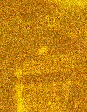
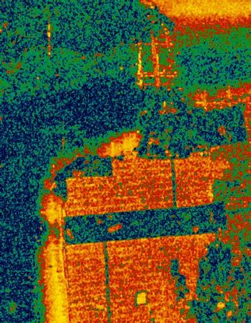
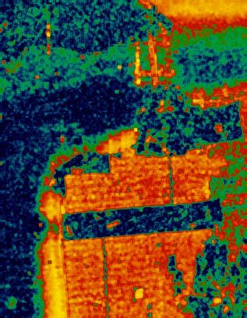
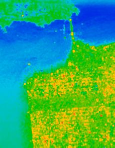
18 ENTROPY BIAS REMOVAL L-band AIRSAR San Francisco

19 ENTROPY BIAS REMOVAL The Ratio L-band PISAR from Tsukuba, Japan

20 ENTROPY BIAS REMOVAL X-band PISAR from Tsukuba, Japan
21 ENTROPY BIAS REMOVAL H( n) R = H ( ) AIRSAR L-band
22 ENTROPY BIAS REMOVAL The Ratio H( n) R = H ( ) X-band and L-band have the same ratio Frequency independent. The ratio depends on the number of looks and H(n)
 H Entropy bias removal: ˆ H ( ) ( ) 0 n H 0 n = R( n) The 3x3 averaged")
23 ENTROPY BIAS REMOVAL 3x3 Average H 0 (7.5) Bias removed ˆ 0(7.5) H Entropy bias removal: ˆ H ( ) ( ) 0 n H 0 n = R( n) The 3x3 averaged data have ENL=7.5


24 ENTROPY BIAS REMOVAL H 0 (18), 5x5 Average Bias removed Hˆ 0(18 ) H ˆ ( n) = H( n) R( n) The 5x5 averaged data have ENL=18

25 ANISOTROPY BIAS REMOVAL E-SAR L-Band The Ratio R A A( n) = A ( ) Surface and volume scattering requires bias removal. Bias removal requires 49 looks data.
26 Anisotropy Bias Removal Ratio for Volume is very high cause the problem for bias removal. To compensate for bias for Volume class, create a ratio curve for Volume class alone. Do the same for Surface.


27 ANISOTROPY BIAS REMOVAL Anisotropy, 7x7 average Bias compensated 13x13 average Surface and volume scattering requires bias removal.
28 ALPHA BIAS EVALUATION E-SAR L-Band The Ratio α = α( n) α( ) Bias is very small Only the surface category requires bias removal

29 ALPHA BIAS EVALUATION 7x7 Average 5x5 Average E-SAR L-Band 13x13 Average Only the surface scattering category may require bias removal for surface geophysical parameter estimation
30 SUMMARY Evaluated the asymptotic behaviors of H and A as a function of the number of looks. Bias removal: Entropy Robust linear characteristics Linear relation is independent radar frequency and radar systems 25 independent looks with bias removal 49 without bias removal Anisotropy Bias removal is required for surface and volume 49 independent looks with bias removal Alpha α Bias is small Bias removal for entropy and alpha for surface is required for soil moister estimation
31 PIXEL CORRELATION EFFECT Assess the effect of over-sampling at 25%, 50% and 100% in both range and azimuth Pixel correlations: (25%), (50%), (100%) At 50%, 5x5 looks has the same underestimate in Entropy of 3x5 (0%). At 100%, very high number of looks is required to reduce bias.
32 PIXEL CORRELATION EFFECT Alpha Angle of λ 1 For Forest (Volume): α for forest has the same peculiar effect Over sampling affects α 1

33 MIXED PIXEL EFFECT Boxcar averaging includes mixed pixels Mixed pixels affect surface scattering pixels: Increase Entropy Decrease Anisotropy Change Averaged Alpha
Application of Bootstrap Techniques for the Estimation of Target Decomposition Parameters in RADAR Polarimetry
 Application of Bootstrap Techniques for the Estimation of Target Decomposition Parameters in RADAR Polarimetry Samuel Foucher Research & Development Dept Computer Research Institute of Montreal Montreal,
A New Model-Based Scattering Power Decomposition for Polarimetric SAR and Its Application in Analyzing Post-Tsunami Effects
 A New Model-Based Scattering Power Decomposition for Polarimetric SAR and Its Application in Analyzing Post-Tsunami Effects Yi Cui, Yoshio Yamaguchi Niigata University, Japan Background (1/5) POLSAR data
SAN FRANCISCO BAY. L-band 1988 AIRSAR. DC8 P, L, C-Band (Quad) Microwaves and Radar Institute, Wolfgang Keydel
 Microwaves and Radar Institute, Wolfgang Keydel") SAN FRANCISCO BAY L-band 1988 AIRSAR DC8 P, L, C-Band (Quad) TARGET GENERATORS HH+VV T11=2A0 HV T33=B0-B HH-VV T22=B0+B TARGET GENERATORS Sinclair Color Coding HH HV VV Pauli Color Coding HH+VV T11=2A0
SAN FRANCISCO BAY L-band 1988 AIRSAR DC8 P, L, C-Band (Quad) TARGET GENERATORS HH+VV T11=2A0 HV T33=B0-B HH-VV T22=B0+B TARGET GENERATORS Sinclair Color Coding HH HV VV Pauli Color Coding HH+VV T11=2A0
Advanced SAR 2 Polarimetry
 Advanced SAR Polarimetry Eric POTTIER Monday 3 September, Lecture D1Lb5-3/9/7 Lecture D1Lb5- Advanced SAR - Polarimetry Eric POTTIER 1 $y RADAR POLARIMETRY $x r Ezt (, ) $z Radar Polarimetry (Polar : polarisation
Making a case for full-polarimetric radar remote sensing
 Making a case for full-polarimetric radar remote sensing Jeremy Nicoll Alaska Satellite Facility, University of Alaska Fairbanks 1 Polarization States of a Coherent Plane Wave electric field vector vertically
General Four-Component Scattering Power Decomposition with Unitary Transformation of Coherency Matrix
 1 General Four-Component Scattering Power Decomposition with Unitary Transformation of Coherency Matrix Gulab Singh, Member, IEEE, Yoshio Yamaguchi, Fellow, IEEE and Sang-Eun Park, Member, IEEE Abstract
New Simple Decomposition Technique for Polarimetric SAR Images
 Korean Journal of Remote Sensing, Vol.26, No.1, 2010, pp.1~7 New Simple Decomposition Technique for Polarimetric SAR Images Kyung-Yup Lee and Yisok Oh Department of Electronic Information and Communication
POLARIMETRY-BASED LAND COVER CLASSIFICATION WITH SENTINEL-1 DATA
 POLARIMETRY-BASED LAND COVER CLASSIFICATION WITH SENTINEL-1 DATA Xavier Banqué (1), Juan M Lopez-Sanchez (2), Daniel Monells (1), David Ballester (2), Javier Duro (1), Fifame Koudogbo (1) (1) Altamira
Model based forest height estimation with ALOS/PalSAR: A first study.
 Model based forest height estimation with ALOS/PalSAR: A first study. K.P. Papathanassiou*, I. Hajnsek*, T.Mette*, S.R. Cloude** and A. Moreira* * (DLR) (DLR-HR) Oberpfaffenhofen, Germany ** AEL Consultants
ADVANCED CONCEPTS POLSARPRO V3.0 LECTURE NOTES. Eric POTTIER (1), Jong-Sen LEE (2), Laurent FERRO-FAMIL (1)
, Jong-Sen LEE (2), Laurent FERRO-FAMIL (1)") ADVANCED CONCEPTS Eric POTTIER (), Jong-Sen LEE (), Laurent FERRO-FAMIL () () I.E.T.R UMR CNRS 664 University of Rennes Image and Remote Sensing Department, SAPHIR Team Campus de Beaulieu, Bat D, 63 Av
ADVANCED CONCEPTS Eric POTTIER (), Jong-Sen LEE (), Laurent FERRO-FAMIL () () I.E.T.R UMR CNRS 664 University of Rennes Image and Remote Sensing Department, SAPHIR Team Campus de Beaulieu, Bat D, 63 Av
Analysis of the Temporal Behavior of Coherent Scatterers (CSs) in ALOS PalSAR Data
 in ALOS PalSAR Data") Analysis of the Temporal Behavior of Coherent Scatterers (CSs) in ALOS PalSAR Data L. Marotti, R. Zandona-Schneider & K.P. Papathanassiou German Aerospace Center (DLR) Microwaves and Radar Institute0 PO.BOX
Analysis of the Temporal Behavior of Coherent Scatterers (CSs) in ALOS PalSAR Data L. Marotti, R. Zandona-Schneider & K.P. Papathanassiou German Aerospace Center (DLR) Microwaves and Radar Institute0 PO.BOX
Spectral Clustering of Polarimetric SAR Data With Wishart-Derived Distance Measures
 Spectral Clustering of Polarimetric SAR Data With Wishart-Derived Distance Measures STIAN NORMANN ANFINSEN ROBERT JENSSEN TORBJØRN ELTOFT COMPUTATIONAL EARTH OBSERVATION AND MACHINE LEARNING LABORATORY
Analysis of Compact Polarimetric SAR Imaging Modes
 Analysis of Compact Polarimetric AR Imaging Modes T. L. Ainsworth 1, M. Preiss, N. tacy, M. Nord 1,3 & J.-. Lee 1,4 1 Naval Research Lab., Washington, DC 0375 UA Defence cience and Technology Organisation,
Comparison between Multitemporal and Polarimetric SAR Data for Land Cover Classification
 Downloaded from orbit.dtu.dk on: Sep 19, 2018 Comparison between Multitemporal and Polarimetric SAR Data for Land Cover Classification Skriver, Henning Published in: Geoscience and Remote Sensing Symposium,
A Multi-component Decomposition Method for Polarimetric SAR Data
 Chinese Journal of Electronics Vol.26, No.1, Jan. 2017 A Multi-component Decomposition Method for Polarimetric SAR Data WEI Jujie 1, ZHAO Zheng 1, YU Xiaoping 2 and LU Lijun 1 (1. Chinese Academy of Surveying
Study and Applications of POLSAR Data Time-Frequency Correlation Properties
 Study and Applications of POLSAR Data Time-Frequency Correlation Properties L. Ferro-Famil 1, A. Reigber 2 and E. Pottier 1 1 University of Rennes 1, Institute of Electronics and Telecommunications of
Land Cover Feature recognition by fusion of PolSAR, PolInSAR and optical data
 Land Cover Feature recognition by fusion of PolSAR, PolInSAR and optical data Shimoni, M., Borghys, D., Heremans, R., Milisavljević, N., Pernel, C. Derauw, D., Orban, A. PolInSAR Conference, ESRIN, 22-26
Polarimetry-based land cover classification with Sentinel-1 data
 Polarimetry-based land cover classification with Sentinel-1 data Banqué, Xavier (1); Lopez-Sanchez, Juan M (2); Monells, Daniel (1); Ballester, David (2); Duro, Javier (1); Koudogbo, Fifame (1) 1. Altamira-Information
DUAL FREQUENCY POLARIMETRIC SAR DATA CLASSIFICATION AND ANALYSIS
 Progress In Electromagnetics Research, PIER 31, 247 272, 2001 DUAL FREQUENCY POLARIMETRIC SAR DATA CLASSIFICATION AND ANALYSIS L. Ferro-Famil Ecole Polytechnique de l Université de Nantes IRESTE, Laboratoire
EVALUATION OF CLASSIFICATION METHODS WITH POLARIMETRIC ALOS/PALSAR DATA
 EVALUATION OF CLASSIFICATION METHODS WITH POLARIMETRIC ALOS/PALSAR DATA Anne LÖNNQVIST a, Yrjö RAUSTE a, Heikki AHOLA a, Matthieu MOLINIER a, and Tuomas HÄME a a VTT Technical Research Centre of Finland,
Intégration de connaissance experte
 Intégration de connaissance experte dans des systèmes de fusion d informationsd Florentin BUJOR, Gabriel VASILE, Lionel VALET Emmanuel TROUVÉ, Gilles MAURIS et Philippe BOLON emmanuel.trouve@univ-savoie.fr
POLARIMETRIC SPECKLE FILTERING
 $y $x r Ezt (, ) $z POLARIMETRIC SPECKLE FILTERING E. Pottier, L. Ferro-Famil (/) SPECKLE FILTERING SPECKLE PHENOMENON E. Pottier, L. Ferro-Famil (/) SPECKLE FILTERING OBSERVATION POINT SURFACE ROUGHNESS
LAND COVER CLASSIFICATION OF PALSAR IMAGES BY KNOWLEDGE BASED DECISION TREE CLASSI- FIER AND SUPERVISED CLASSIFIERS BASED ON SAR OBSERVABLES
 Progress In Electromagnetics Research B, Vol. 30, 47 70, 2011 LAND COVER CLASSIFICATION OF PALSAR IMAGES BY KNOWLEDGE BASED DECISION TREE CLASSI- FIER AND SUPERVISED CLASSIFIERS BASED ON SAR OBSERVABLES
EE/Ge 157 b. Week 2. Polarimetric Synthetic Aperture Radar (2)
") EE/Ge 157 b Week 2 Polarimetric Synthetic Aperture Radar (2) COORDINATE SYSTEMS All matrices and vectors shown in this package are measured using the backscatter alignment coordinate system. This system
EE/Ge 157 b Week 2 Polarimetric Synthetic Aperture Radar (2) COORDINATE SYSTEMS All matrices and vectors shown in this package are measured using the backscatter alignment coordinate system. This system
Unsupervised Wishart Classifications of Sea-Ice using Entropy, Alpha and Anisotropy decompositions
 Unsupervised Wishart Classifications of Sea-Ice using Entropy, Alpha and Anisotropy decompositions A. Rodrigues (1), D. Corr (1), K. Partington (2), E. Pottier (3), L. Ferro-Famil (3) (1) QinetiQ Ltd,
STUDIES OF OCEAN S SCATTERING PROPERTIES BASED ON AIRSAR DATA
 STUDIES OF OCEAN S SCATTERING PROPERTIES BASED ON AIRSAR DATA Wang Wenguang *, Sun Jinping, Wang Jun, Hu Rui School of EIE, Beihang University, Beijing 00083, China- wwenguang@ee.buaa.edu.cn KEY WORDS:
On the use of Matrix Information Geometry for Polarimetric SAR Image Classification
 On the use of Matrix Information Geometry for Polarimetric SAR Image Classification Pierre Formont 1,2,Jean-PhilippeOvarlez 1,andFrédéric Pascal 2 1 French Aerospace Lab, ONERA DEMR/TSI, France 2 E3S-SONDRA,
Soil moisture retrieval over periodic surfaces using PolSAR data
 Soil moisture retrieval over periodic surfaces using PolSAR data Sandrine DANIEL Sophie ALLAIN Laurent FERRO-FAMIL Eric POTTIER IETR Laboratory, UMR CNRS 6164, University of Rennes1, France Contents Soil
THE OBJECTIVE of the incoherent target decomposition
 IEEE TRANSACTIONS ON GEOSCIENCE AND REMOTE SENSING, VOL. 45, NO. 1, JANUARY 2007 73 Target Scattering Decomposition in Terms of Roll-Invariant Target Parameters Ridha Touzi, Member, IEEE Abstract The Kennaugh
THE PYLA 2001 EXPERIMENT : EVALUATION OF POLARIMETRIC RADAR CAPABILITIES OVER A FORESTED AREA
 THE PYLA 2001 EXPERIMENT : EVALUATION OF POLARIMETRIC RADAR CAPABILITIES OVER A FORESTED AREA M. Dechambre 1, S. Le Hégarat 1, S. Cavelier 1, P. Dreuillet 2, I. Champion 3 1 CETP IPSL (CNRS / Université
POLARIMETRIC SAR MODEL FOR SOIL MOISTURE ESTIMATION OVER VINEYARDS AT C-BAND
 Progress In Electromagnetics Research, Vol. 142, 639 665, 213 POLARIMETRIC SAR MODEL FOR SOIL MOISTURE ESTIMATION OVER VINEYARDS AT C-BAND J. David Ballester-Berman *, Fernando Vicente-Guijalba, and Juan
A Family of Distribution-Entropy MAP Speckle Filters for Polarimetric SAR Data, and for Single or Multi-Channel Detected and Complex SAR Images
 A Family of Distribution-Entropy MAP Specle Filters for Polarimetric SAR Data, and for Single or Multi-Channel Detected and Complex SAR Images Edmond NEZRY and Francis YAKAM-SIMEN PRIVATEERS N.V., Private
Improving PolSAR Land Cover Classification With Radiometric Correction of the Coherency Matrix
 IEEE JOURNAL OF SELECTED TOPICS IN APPLIED EARTH OBSERVATIONS AND REMOTE SENSING 1 Improving PolSAR Land Cover Classification With Radiometric Correction of the Coherency Matrix Donald K. Atwood, Member,
Polarimetric Calibration of the Ingara Bistatic SAR
 Polarimetric Calibration of the Ingara Bistatic SAR Alvin Goh, 1,2 Mark Preiss, 1 Nick Stacy, 1 Doug Gray 2 1. Imaging Radar Systems Group Defence Science and Technology Organisation 2. School of Electrical
BUILDING HEIGHT ESTIMATION USING MULTIBASELINE L-BAND SAR DATA AND POLARIMETRIC WEIGHTED SUBSPACE FITTING METHODS
 BUILDING HEIGHT ESTIMATION USING MULTIBASELINE L-BAND SAR DATA AND POLARIMETRIC WEIGHTED SUBSPACE FITTING METHODS Yue Huang, Laurent Ferro-Famil University of Rennes 1, Institute of Telecommunication and
Log-Cumulants of the Finite Mixture Model and Their Application to Statistical Analysis of Fully Polarimetric UAVSAR Data
 Log-Cumulants of the Finite Mixture Model and Their Application to Statistical Analysis of Fully Polarimetric UAVSAR Data Xinping Deng a, Jinsong Chen a, Hongzhong Li a, Pengpeng Han a, and Wen Yang b
Fitting a two-component scattering model to polarimetric SAR data from forests
 Fitting a two-component scattering model to polarimetric SAR data from forests A. Freeman, Fellow, IEEE Jet Propulsion Laboratory, California Institute of Technology 4800 Oak Grove Drive, Pasadena, CA
ABSTRACT. Index terms compact polarimetry, Faraday rotation, bare soil surfaces, soil moisture.
 COPARION BETWEEN THE CONFORITY COEFFICIENT AND PREVIOU CLAIFICATION TECHNIQUE FOR BARE URFACE DICRIINATION AND APPLICATION TO COPACT POLARIETRY ODE y-linh Truong-Loï 13, A. Freeman, P. Dubois-Fernandez
Dry Snow Analysis in Alpine Regions using RADARSAT-2 Full Polarimetry Data. Comparison With In Situ Measurements
 Dry Snow Analysis in Alpine Regions using RADARSAT-2 Full Polarimetry Data. Comparison With In Situ Measurements Jean-Pierre Dedieu, Nikola Besic, Gabriel Vasile, J. Mathieu, Yves Durand, F. Gottardi To
Modeling Surface and Subsurface Scattering from Saline Soils
 Modeling Surface and Subsurface Scattering from Saline Soils PolInSAR 2007 Tony Freeman, Jet Propulsion Laboratory Tom Farr, Jet Propulsion Laboratory Philippe Paillou, Astronomical Observatory of Bordeaux
TEXTURE ANALSYS OF SAR IMAGERY IN THE SPACE-SCALE-POLARIZATION DOMAIN BY WAVELET FRAMES
 TEXTURE ANALSYS OF SAR IMAGERY IN THE SPACE-SCALE-POLARIZATION DOMAIN BY WAVELET FRAMES G. De Grandi 1, J. Kropacek 1, A. Gambardella 2, R.M. Lucas 3, M. Migliaccio 2 Joint Research Centre 21027, Ispra
Estimation of the Equivalent Number of Looks in Polarimetric Synthetic Aperture Radar Imagery
 PUBLISHED IN IEEE TRANSACTIONS ON GEOSCIENCE AND REMOTE SENSING, VOL. 47, NO., NOVEMBER 9 Estimation of the Equivalent Number of Looks in Polarimetric Synthetic Aperture Radar Imagery Stian Normann Anfinsen,
Polarimetric Incoherent Target Decomposition by Means of Independent Component Analysis
 Author manuscript, published in "IEEE Transactions on Geoscience and Remote Sensing 53, 3 (5) pages" DOI :.9/TGRS.4.33638 IEEE TRANSACTIONS ON GEOSCIENCE AND REMOTE SENSING, DOI:.9/TGRS.4.33638 (postprint)
CLASSIFICATION, decomposition, and modeling of polarimetric
 IEEE TRANSACTIONS ON GEOSCIENCE AND REMOTE SENSING, VOL. 36, NO. 3, MAY 1998 963 A Three-Component Scattering Model for Polarimetric SAR Data Anthony Freeman, Senior Member, IEEE, Stephen L. Durden Abstract
A New Approach to Estimate Forest Parameters Using Dual-Baseline POL-InSAR Data
 Jan 26-30, 2009 Frascati, Italy A New Approach to Estimate Forest Parameters Using Dual-Baseline POL-InSAR Data Lu Bai, Wen ong, Fang Cao, Yongsheng Zhou bailu8@gmail.com fcao@mail.ie.ac.cn National Key
Evaluation of the Sacttering Matrix of Flat Dipoles Embedded in Multilayer Structures
 PIERS ONLINE, VOL. 4, NO. 5, 2008 536 Evaluation of the Sacttering Matrix of Flat Dipoles Embedded in Multilayer Structures S. J. S. Sant Anna 1, 2, J. C. da S. Lacava 2, and D. Fernandes 2 1 Instituto
1328 IEEE GEOSCIENCE AND REMOTE SENSING LETTERS, VOL. 14, NO. 8, AUGUST 2017
 1328 IEEE GEOSCIENCE AND REMOTE SENSING LETTERS, VOL. 14, NO. 8, AUGUST 2017 An Extension of the Alpha Approximation Method for Soil Moisture Estimation Using Time-Series SAR Data Over Bare Soil Surfaces
IEEE Copyright notice.
 This is a pre print version of the paper. Please cite the final version of the paper: G. Di Martino, A. Iodice, A. Natale and D. Riccio, Polarimetric Two Scale Two omponent Model for the Retrieval of Soil
Screening of Earthen Levees using TerraSAR-X Radar Imagery
 Screening of Earthen Levees using TerraSAR-X Radar Imagery James Aanstoos (1), Khaled Hasan (1), Majid Mahrooghy (1), Lalitha Dabbiru (1), Rodrigo Nobrega (1), Saurabh Prasad (1) (1) Geosystems Research
Polarimetric synthetic aperture radar study of the Tsaoling landslide generated by the 1999 Chi-Chi earthquake, Taiwan
 JOURNAL OF GEOPHYSICAL RESEARCH, VOL. 108, NO. F1, 6006, doi:10.1029/2003jf000037, 2003 Polarimetric synthetic aperture radar study of the Tsaoling landslide generated by the 1999 Chi-Chi earthquake, Taiwan
Multitemporal RADARSAT 2 Fine Beam Polarimetric SAR for Urban Land Cover Mapping
 Multitemporal RADARSAT 2 Fine Beam Polarimetric SAR for Urban Land Cover Mapping Yifang Ban & Xin Niu KTH Royal Institute of Technology Stockholm, Sweden Introduction Urban represents one of the most dynamic
2986 IEEE TRANSACTIONS ON GEOSCIENCE AND REMOTE SENSING, VOL. 51, NO. 5, MAY 2013
 986 IEEE TRANSACTIONS ON GEOSCIENCE AND REMOTE SENSING, VOL. 51, NO. 5, MAY 013 A New Polarimetric Change Detector in Radar Imagery Armando Marino, Member, IEEE, Shane R. Cloude, Fellow, IEEE, and Juan
Target Detection Studies Using Fully Polarimetric Data Collected by the Lincoln Laboratory MMW SAR. L.M. Novak MIT Lincoln Laboratory
 Target Detection Studies Using Fully Polarimetric Data Collected by the Lincoln Laboratory MMW SAR Abstract L.M. Novak MIT Lincoln Laboratory Under DARPA sponsorship, MIT Lincoln Laboratory is investigating
The 3rd International Workshop on Science and Applications of SAR Polarimetry and Polarimetric Interferometry
 SP-644 March 2007 Proceedings of PolInSAR 2007 The 3rd International Workshop on Science and Applications of SAR Polarimetry and Polarimetric Interferometry 22 26 January 2007 ESRIN Frascati, Italy Scientific
J2.6 SONAR MEASUREMENTS IN THE GULF STREAM FRONT ON THE SOUTHEAST FLORIDA SHELF COORDINATED WITH TERRASAR-X SATELLITE OVERPASSES
 J2.6 SONAR MEASUREMENTS IN THE GULF STREAM FRONT ON THE SOUTHEAST FLORIDA SHELF COORDINATED WITH TERRASAR-X SATELLITE OVERPASSES Chris Maingot 1, Alexander Soloviev 1, Silvia Matt 1, Mikhail Gilman 1,
GLOBAL FOREST CLASSIFICATION FROM TANDEM-X INTERFEROMETRIC DATA: POTENTIALS AND FIRST RESULTS
 GLOBAL FOREST CLASSIFICATION FROM TANDEM-X INTERFEROMETRIC DATA: POTENTIALS AND FIRST RESULTS Michele Martone, Paola Rizzoli, Benjamin Bräutigam, Gerhard Krieger Microwaves and Radar Institute German Aerospace
An Introduction to PolSAR-Ap: Exploitation of Fully Polarimetric SAR Data for Application Demonstration
 An Introduction to PolSAR-Ap: Exploitation of Fully Polarimetric SAR Data for Application Demonstration Irena Hajnsek, Matteo Pardini, Kostas Papathanassiou, Shane Cloude, Juan M. Lopez-Sanchez, David
MARINE AND MARITIME SAR APPLICATIONS: COSMO-SKYMED FROM 1 ST TO 2 ND GENERATION
 MARINE AND MARITIME SAR APPLICATIONS: COSMO-SKYMED FROM 1 ST TO 2 ND GENERATION Maurizio Migliaccio, Ferdinando Nunziata, Andrea Buono Dipartimento di Ingegneria, Università degli Studi di Napoli Parthenope
Surface Deformation Measurements Scientific Requirements & Challenges
 Surface Deformation Measurements Scientific Requirements & Challenges 1st Science and Application Workshop for Germany-Japan Next-Generation SAR M. Eineder, C. Minet, A. Parizzi Tokyo, 27.6.2013 Tandem-L
SEA OIL spill pollution is a matter of great concern since
 506 IEEE TRANSACTIONS ON GEOSCIENCE AND REMOTE SENSING, VOL. 45, NO. 2, FEBRUARY 2007 SAR Polarimetry to Observe Oil Spills Maurizio Migliaccio, Senior Member, IEEE, Attilio Gambardella, Student Member,
POLARIMETRIC and interferometric synthetic aperture
 IEEE TRANSACTIONS ON GEOSCIENCE AND REMOTE SENSING, VOL. 45, NO. 11, NOVEMBER 2007 3599 Polarimetric and Interferometric SAR Image Partition Into Statistically Homogeneous Regions Based on the Minimization
Remote Sensing for Agriculture, Ecosystems, and Hydrology V, edited by Manfred Owe, Guido D Urso, Jose F. Moreno, Alfonso Calera, Proceedings of SPIE
 Electromagnetic model of rice crops for wideband POLINSAR J. Fortuny-Guasch and A. Martinez-Vazquez a, J.M. Lopez-Sanchez and J.D. Ballester-Berman b a DG Joint Research Centre of the European Commission
DUAL-POLARIZED COSMO SKYMED SAR DATA TO OBSERVE METALLIC TARGETS AT SEA
 DUAL-POLARIZED COSMO SKYMED SAR DATA TO OBSERVE METALLIC TARGETS AT SEA F. Nunziata, M. Montuori and M. Migliaccio Università degli Studi di Napoli Parthenope Dipartimento per le Tecnologie Centro Direzionale,
Detecting an area affected by forest fires using ALOS PALSAR
 Detecting an area affected by forest fires using ALOS PALSAR Keiko Ishii (1), Masanobu Shimada (2), Osamu Isoguchi (2), Kazuo Isono (1) (1)Remote Sensing Technology Center of Japan (2)Japan Aerospace Exploration
THE THEMATIC INFORMATION EXTRACTION FROM POLINSAR DATA FOR URBAN PLANNING AND MANAGEMENT
 THE THEMATIC INFORMATION EXTRACTION FROM POLINSAR DATA FOR URBAN PLANNING AND MANAGEMENT D.Amarsaikhan a, *, M.Sato b, M.Ganzorig a a Institute of Informatics and RS, Mongolian Academy of Sciences, av.enkhtaivan-54b,
Knowledge-based sea ice classification by polarimetric SAR
 Downloaded from orbit.dtu.dk on: Dec 17, 217 Knowledge-based sea ice classification by polarimetric SAR Skriver, Henning; Dierking, Wolfgang Published in: IEEE International Geoscience Remote Sensing Symposium,
Determining the Points of Change in Time Series of Polarimetric SAR Data
 Downloaded from orbit.dtu.dk on: Jul 4, 28 Determining the Points of Change in Time Series of Polarimetric SAR Data Conradsen, Knut; Nielsen, Allan Aasbjerg; Skriver, Henning Published in: IEEE Transactions
Decomposition of polarimetric synthetic aperture radar backscatter from upland and ooded forests
 int. j. remote sensing, 1997, vol. 18, no. 6, 1319± 1332 Decomposition of polarimetric synthetic aperture radar backscatter from upland and ooded forests Y. WANG Department of Geography, East Carolina
ASSESSMENT OF L-BAND SAR DATA AT DIFFERENT POLARIZATION COMBINATIONS FOR CROP AND OTHER LANDUSE CLASSIFICATION
 Progress In Electromagnetics Research B, Vol. 36, 303 321, 2012 ASSESSMENT OF L-BAND SAR DATA AT DIFFERENT POLARIZATION COMBINATIONS FOR CROP AND OTHER LANDUSE CLASSIFICATION D. Haldar 1, *, A. Das 1,
Archimer
 Please note that this is an author-produced PDF of an article accepted for publication following peer review. The definitive publisher-authenticated version is available on the publisher Web site Ieee
THE fully polarimetric synthetic aperture radar (PolSAR)
") IEEE TRANSACTIONS ON GEOSCIENCE AND REMOTE SENSING 1 Unsupervised Classification of Polarimetric SAR Images via Riemannian Sparse Coding Neng Zhong, Student Member, IEEE, Wen Yang, Senior Member, IEEE,
IEEE TRANSACTIONS ON GEOSCIENCE AND REMOTE SENSING 1 Unsupervised Classification of Polarimetric SAR Images via Riemannian Sparse Coding Neng Zhong, Student Member, IEEE, Wen Yang, Senior Member, IEEE,
PUBLICATIONS. Radio Science. Impact of cross-polarization isolation on polarimetric target decomposition and target detection
 PUBLICATIONS RESEARCH ARTICLE Key Points: Prior studies are on calibration; we evaluate its impact from users perspective Impact on polarimetric target decomposition is analyzed, and 25 db is concluded
Multitemporal Spaceborne Polarimetric SAR Data for Urban Land Cover Mapping
 Multitemporal Spaceborne Polarimetric SAR Data for Urban Land Cover Mapping Xin Niu Feburary 2011 TRITA SoM 2011-05 ISSN 1653-6126 ISRN KTH/SoM/11-05/SE ISBN 978-91-7415-909-7 Xin Niu TRITA SoM 2011-05
Principal Component Analysis (PCA) of AIRS Data
 of AIRS Data") Principal Component Analysis (PCA) of AIRS Data Mitchell D. Goldberg 1, Lihang Zhou 2, Walter Wolf 2 and Chris Barnet 1 NOAA/NESDIS/Office of Research and Applications, Camp Springs, MD 1 QSS Group Inc.
Principal Component Analysis (PCA) of AIRS Data Mitchell D. Goldberg 1, Lihang Zhou 2, Walter Wolf 2 and Chris Barnet 1 NOAA/NESDIS/Office of Research and Applications, Camp Springs, MD 1 QSS Group Inc.
A Test Statistic in the Complex Wishart Distribution and Its Application to Change Detection in Polarimetric SAR Data
 4 IEEE TRANSACTIONS ON GEOSCIENCE AND REMOTE SENSING, VOL. 41, NO. 1, JANUARY 2003 A Test Statistic in the Complex Wishart Distribution and Its Application to Change Detection in Polarimetric SAR Data
ANALYSIS OF ASAR POLARISATION SIGNATURES FROM URBAN AREAS (AO-434)
") ANALYSIS OF ASAR POLARISATION SIGNATURES FROM URBAN AREAS (AO-434) Dan Johan Weydahl and Richard Olsen Norwegian Defence Research Establishment (FFI), P.O. Box 25, NO-2027 Kjeller, NORWAY, Email: dan-johan.weydahl@ffi.no
ANALYSIS OF ASAR POLARISATION SIGNATURES FROM URBAN AREAS (AO-434) Dan Johan Weydahl and Richard Olsen Norwegian Defence Research Establishment (FFI), P.O. Box 25, NO-2027 Kjeller, NORWAY, Email: dan-johan.weydahl@ffi.no
K.-C. Lee, J.-S. Ou, andc.-w. Huang Department of Systems and Naval Mechatronic Engineering National Cheng-Kung University Tainan 701, Taiwan
 Progress In Electromagnetics Research, PIER 72, 145 158, 2007 ANGULAR-DIVERSITY RADAR RECOGNITION OF SHIPS BY TRANSFORMATION BASED APPROACHES INCLUDING NOISE EFFECTS K.-C. Lee, J.-S. Ou, andc.-w. Huang
Linking Different Spatial Scales For Retrieval Of Sea Ice Conditions From SAR Images
 Linking Different Spatial Scales For Retrieval Of Sea Ice Conditions From SAR Images Matt Arkett 2, Wolfgang Dierking 1, Jakob Griebel 1, Thomas Hollands 1, Stefanie Linow 1, Eero Rinne 3, Markku Similä
Product Delivery Report for K&C Phase 2. Kyle McDonald Jet Propulsion Lab California Institute of Technology
 Product Delivery Report for K&C Phase 2 Kyle McDonald Jet Propulsion Lab California Institute of Technology Science Team meeting #15 JAXA TKSC/RESTEC HQ, Tsukuba/Tokyo, January 24-28, 2011 1. Published
STUDY OF BACKSCATTER SIGNATURE FOR SEEDBED SURFACE EVOLUTION UNDER RAINFALL INFLU- ENCE OF RADAR PRECISION
 Progress In Electromagnetics Research, Vol. 125, 415 437, 2012 STUDY OF BACKSCATTER SIGNATURE FOR SEEDBED SURFACE EVOLUTION UNDER RAINFALL INFLU- ENCE OF RADAR PRECISION R. Dusséaux 1, *, E. Vannier, O.
Wave Propagation Model for Coherent Scattering from a Randomly Distributed Target
 Wave Propagation Model for Coherent Scattering from a Randomly Distributed Target Don Atwood,Ben Matthiss, Liza Jenkins, Shimon Wdowinski, Sang Hoon Hong, and Batuhan Osmanoglu Outline Requirements for
Sea Ice Detection in the Sea of Okhotsk Using PALSAR and MODIS Data
 1516 IEEE JOURNAL OF SELECTED TOPICS IN APPLIED EARTH OBSERVATIONS AND REMOTE SENSING, VOL. 6, NO. 3, JUNE 2013 Sea Ice Detection in the Sea of Okhotsk Using PALSAR and MODIS Data Hiroyuki Wakabayashi,
Possible Use of Synthetic Aperture Radar Images in IACS
 Possible Use of Synthetic Aperture Radar Images in IACS 51st Panta Rhei Conference Hungary - April 2017. György Surek Zoltán Friedl - Gizella Nádor - Mátyás Rada - Anikó Kulcsár - Irén Hubik Government
SAR Data Analysis: An Useful Tool for Urban Areas Applications
 SAR Data Analysis: An Useful Tool for Urban Areas Applications M. Ferri, A. Fanelli, A. Siciliano, A. Vitale Dipartimento di Scienza e Ingegneria dello Spazio Luigi G. Napolitano Università degli Studi
Investigating Coastal Polynya Thin Sea Ice State in the Laptev Sea Using TerraSAR-X Dual-Pol Stripmap Data
 Investigating Coastal Polynya Thin Sea Ice State in the Laptev Sea Using TerraSAR-X Dual-Pol Stripmap Data Thomas Busche (1), Irena Hajnsek (1), Thomas Krumpen (2), Lasse Rabenstein (2), Jens Hoelemann
WITH the rapid industrial and human population growth. Analysis and Applications of Backscattered Frequency Correlation Function
 IEEE TRANSACTIONS ON GEOSCIENCE AND REMOTE SENSING, VOL. 37, NO. 4, JULY 1999 1895 Analysis and Applications of Backscattered Frequency Correlation Function Kamal Sarabandi, Senior Member, IEEE, and Adib
SNOW MASS RETRIEVAL BY MEANS OF SAR INTERFEROMETRY
 SNOW MASS RETRIEVAL BY MEANS OF SAR INTERFEROMETRY Helmut Rott (1), Thomas Nagler (1), Rolf Scheiber (2) (1) ENVEO, Environmental Earth Observation OEG, Exlgasse 39, A-6020 Innsbruck, Austria E-mail: Helmut.Rott@enveo.at
Study on the rainfall dependence structure using radar and rain gauge data
 International Workshop Advances in Statistical hydrology, May 23-25 2010, Taormina, Italy Study on the rainfall dependence structure using radar and rain gauge data V. Montesarchio, F. Russo, F. Napolitano
The Importance of Microwave Remote Sensing for Operational Sea Ice Services And Challenges
 The Importance of Microwave Remote Sensing for Operational Sea Ice Services And Challenges Wolfgang Dierking January 2015 (1) Why is microwave remote sensing important (=useful) for sea ice mapping? Problems
Dependencies of the Doppler Velocity from X-Band Backscatter at Grazing Incidence
 SOMaR-4 Workshop Dependencies of the Doppler Velocity from X-Band Backscatter at Grazing Incidence 9-11th of May, 2017 / Lüneburg Michael Streßer Ruben Carrasco, Marius Cysewski, Jörg Seemann and Jochen
APPLICATION OF ICA TECHNIQUE TO PCA BASED RADAR TARGET RECOGNITION
 Progress In Electromagnetics Research, Vol. 105, 157 170, 2010 APPLICATION OF ICA TECHNIQUE TO PCA BASED RADAR TARGET RECOGNITION C.-W. Huang and K.-C. Lee Department of Systems and Naval Mechatronic Engineering
Coherency Matrix Estimation of Heterogeneous Clutter in High-Resolution Polarimetric SAR Images
 IEEE TRANSACTIONS ON GEOSCIENCE AND REMOTE SENSING 1 Coherency Matrix Estimation of Heterogeneous Clutter in High-Resolution Polarimetric SAR Images Gabriel Vasile, Member, IEEE, Jean-Philippe Ovarlez,
MULTIPLE-CHANNEL DETECTION IN ACTIVE SENSING. Kaitlyn Beaudet and Douglas Cochran
 MULTIPLE-CHANNEL DETECTION IN ACTIVE SENSING Kaitlyn Beaudet and Douglas Cochran School of Electrical, Computer and Energy Engineering Arizona State University, Tempe AZ 85287-576 USA ABSTRACT The problem
A Statistical Kirchhoff Model for EM Scattering from Gaussian Rough Surface
 Progress In Electromagnetics Research Symposium 2005, Hangzhou, China, August 22-26 187 A Statistical Kirchhoff Model for EM Scattering from Gaussian Rough Surface Yang Du 1, Tao Xu 1, Yingliang Luo 1,
LAND COVER CLASSIFICATION BASED ON SAR DATA IN SOUTHEAST CHINA
 LAND COVER CLASSIFICATION BASED ON SAR DATA IN SOUTHEAST CHINA Mr. Feilong Ling, Dr. Xiaoqin Wang, Mr.Xiaoming Shi Fuzhou University, Level 13, Science Building,No.53 Gongye Rd., 35, Fuzhou, China Email:
ANALYSIS OF LEAF AREA INDEX AND SOIL WATER CONTENT RETRIEVAL FROM AGRISAR DATA SETS
 ANALYSIS OF LEAF AREA INDEX AND SOIL WATER CONTENT RETRIEVAL FROM AGRISAR DATA SETS D'Urso, G. () ; Dini, L. () ; Richter, K. () ; Palladino M. () () DIIAT, Faculty of Agraria, University of Naples Federico
Understanding C-Band Radar Backscatter From Wheat Canopy Using a Multiple-Scattering Coherent Model
 IEEE TRANSACTIONS ON GEOSCIENCE AND REMOTE SENSING, VOL. 41, NO. 7, JULY 2003 1583 Understanding C-Band Radar Backscatter From Wheat Canopy Using a Multiple-Scattering Coherent Model Ghislain Picard, Thuy
Pi-SAR-L2 Observation of the Landslide Caused by Typhoon Wipha on Izu Oshima Island
 remote sensing Article Pi-SAR-L2 Observation of Landslide Caused by Typhoon Wipha on Izu Oshima Island Manabu Watanabe 1, *, Rajesh Bahadur Thapa 1 and Masanobu Shimada 1,2 1 Earth Observation Research
Feasibility of snow water equivalent retrieval by means of interferometric ALOS PALSAR data
 Feasibility of snow water equivalent retrieval by means of interferometric ALOS PALSAR data, Florian Müller, Helmut Rott, and Markus Heidinger ENVEO Technikerstrasse 21a, A 6020 Innsbruck, Austria www.galahad-euproject.org
STANDWISE CHANGE DETECTION FOR GROWING STOCK USING REPEAT-PASS ALOS PALSAR / PALSAR-2 DATA
 STANDWISE CHANGE DETECTION FOR GROWING STOCK USING REPEAT-PASS ALOS PALSAR / PALSAR-2 DATA M. G. Hong a, C. Kim b * a Dept. of Applied Information Technology, Kookmin University, Seoul 02707, Korea hd21351@kookmin.ac.kr