The need for geological and petrophysical constraints in geophysical inversion
|
|
|
- Frederick Dean
- 5 years ago
- Views:
Transcription

1 The need for geological and petrophysical constraints in geophysical inversion Peter Fullagar Fullagar Geophysics Pty Ltd Brisbane Glenn Pears Mira Geoscience Asia Pacific Pty Ltd Brisbane
2 Acknowledgements Prominent Hill inversion results presented by kind permission of OZ Minerals Spectrem example courtesy Anglo American Exploration Mt Dore study courtesy Geological Survey of Queensland Bull Creek data provided by ExcoResources
3 Outline Introduction Constrained inversion as a geological modelling tool Geological and petrophysical constraints Opportunities and roadblocks Conclusions
4 Introduction Unconstrained inversion Constrained inversion Stochastic inversion
5 Unconstrained inversion We define unconstrained inversion as a computational process used to find one model which satisfies a geophysical data set alone. The starting model is homogeneous. In fact unconstrained inversion is always constrained implicitly, e.g. by model cell sizes, default conditioning (depth penalty function, smoothness) Unconstrained inversion may also be constrained explicitly, e.g. via property bounds (including positivity)
6 Unconstrained inversion of geophysical data in isolation may be effective for targeting. Suitable for production line: data QC and first-pass interpretation Deterministic Unconstrained inversion cont d Typical users: contractors, mining companies
7 Constrained Inversion flow chart measured data end comparator model forward modelling algorithm synthetic data updates inversion algorithm
8 Constrained inversion We define constrained inversion here as a interpretational process used to find a model which satisfies the geophysical data while honouring all available geological information. The starting model is geologically-inspired. Constraints may be hard, enforcing observations, or soft, favouring characteristics Typical users: consultants, mining companies
9 Constrained inversion cont d According to our definition, constrained inversion is deterministic, in keeping with conventional geological modelling Exploration decisions usually based on a single best information geological model: deterministic Stochastic inversion can be constrained also. Constrained determimistic is unwieldy
10 Stochastic inversion Stochastic approaches endeavour to characterise the entire suite of possible models in statistical fashion Probabilistic approach is computationally onerous and probabilities themselves are uncertain. Typical users: universities, government agencies Deterministic methodologies carry additional risk, but exploration driven by possibility rather than probability The most probable model may not be very interesting
11 The elusive exploration target Geologically probable Geophysically acceptable Commercially viable
12 Part 1 Constrained inversion as a geological modelling tool Inversion as a component of Earth modelling Advantages of inverting a geological model
13 Inversion as a component of Earth modelling Geophysics is increasingly deployed as a mapping tool, to deliver an improved geological map of the area of interest. The role of inversion is to extend the map into the 3 rd dimension hence to create or refine a 3D geological model Inversion can be regarded as a component in an overarching effort to build, ideally, a cross-disciplinary interpretation, aka common Earth model (CEM)
")
14 Non-uniqueness DC resistivity inversions (Oldenburg & Li???)

15 Non-uniqueness Ambiguity not a purely geophysical phenomenon Sources of non-uniqueness: 1. Intrinsic physical limitations 2. Finite extent and spatial density of data 3. Errors on the data 4. [Lack of property contrast: S/N, geological ambiguity] Red Dog, Alaska lithology sections density sections (per favour CAMIRO)
16 Uniqueness & the role of constraints Geophysics maps variations in rock properties. There are usually an infinite number of rock property models satisfying the geophysical data acceptably well. Constraints required in order to 1. incorporate what is known about the geology, and 2. reject models inconsistent with what is already known.


17 Geological models Geological models are comprised of rock type domains, their attributes, and the boundaries (contacts, structures) which enclose them Geological models are categorical, insofar as each domain is assigned to a rock type
18 Geological models Models for geophysical inversion must be petrophysical, and can also be geological In conventional petrophysical(or property) models the subsurface is divided into cells with one or more physical properties, but no rock type. Cell boundaries in petrophysicalmodels are often artificial, i.e. bear no relation to geological contacts and structures. artificial boundaries real boundaries
19 Geological modelling Commonly a recursive process in response to successive campaigns of data acquisition geological (drilling), geochemical, geophysical The first stage is usually surface-building Inversion too can be viewed as a sequence of recursive steps not a single program run If applied to a geological model, inversion becomes one of the modelling options in the toolbox
20 Model cells Geological model for inversion Cells have rock type as well as property Categorical VPmg model structure
21 Surface Modelling Options low resolution high resolution geometry inversion (given useful contrasts) stochastic/ stratigraphic interpolation zero Swiss cheese density of drilling
22 Property Modelling Options smooth discontinuous random low resolution high resolution property inversion geostatistics interpolation/sampling zero high spatial density of petrophysical data
23 Advantages of inverting a geological model Strong driver for integration Natural constraint assignment Geometry inversion as well as property inversion Fast optimisation of homogeneous properties Greater control of inversion volume Assign magnetic remanence to geological units Assign statistical distributions according to rock type Regard as either geology or property model Unconstrained inversion still an option

24 Geometry inversion Generally achieved either by Reclassifying cells, with fixed cell boundaries, or Moving the cell boundaries, changing cell shape. Original Shape Cell defection (Bosch et al, 3DWEG) Cell deformation (VPmg)


25 Homogeneous Property Inversion Geometry fixed, only the properties of selected active units change 9 Fast inversion, only a few active parameters Model rarely fits data after hmgsproperty inversion
")
 51500 52500 EW sections")

26 Homogeneous property inversion Adjust unit properties in order to minimise misfit, with model geometry fixed Susc (SI) (log stretch) Starting Model Susc (SI) (log stretch) Inverted Model Observed TMI (nt) EW sections separated by 100m shown zero susc units are transparent Computed response for starting model Computed response after homog inversion

27 Single heterogeneous unit inversion Susceptibility changes restricted to one unit Additional control offered by geological models

28 Magnetic remanence W E W E Q=2.3 dec=109 inc=+25 Q=2.3 dec=270 inc=-70 Assign magnetic remanence to geological units
29 Perceived disadvantages of inverting a geological model time required to construct model at the outset* (though normally it either exists or not) time required to simplify an existing geological model time required to compile and analyse physical property data. * can be reduced by implicit geological modelling software
30 Part 2 Geological and petrophysicalconstraints Types of geological constraints Types of petrophysical constraints Howmany constraints make a difference?

 3.")
31 Geologically-and petrophysically-constrained inversion Purpose of geological & petrophysical constraints: 1. To restrain geologists 2. To impose ground truth ( hard constraints) 3. To condition the inversion to emulate ground truth ( soft constraints)
32 Geologically-constrained and petrophysically-constrained inversion Geologically-constrainedinversion is explicitly or implicitly constrained by geological observations. The intent is to preserve or favour certain geological characteristics. Petrophysically-constrainedinversion honours petrophysicalmeasurements, either explicitly or (geo)statistically or both. The intent is to preserve or favour certain petrophysical characteristics
33 Types of geological constraints on contacts, rock types, and structures Hard constraints fix model parameter values Soft constraints favour characteristics in a statistical sense Constraints imposing/favouring observedattributes are real Constraints imposed by user or by default are artificial Geometry constraints Fix drilled or mapped contacts during geometry inversion Geological logs limit changes to contact geometry Boundaries prevented from crossing one another Changes damped in neighbourhood of pierce point Control volume and shape of lithological domains.
34 Pierce point and bound constraints in VPmg geometry inversion Drill hole P Green depicts the original model surfaces Red depicts the fixed horizontal cell boundaries constrained by the drill hole. Bound locations P Dotted blue are bound constraints
35 Drill hole pierce point neighbourhood of influence Radius of influence controls derivative weighting Weights from nearby pierce points combined multiplicatively: rjk w j = k R Greendepicts the original model surfaces Blackdepicts the horizontal and vertical cell boundaries of the VPmg model Reddepicts the fixed horizontal cell boundaries constrained by the drill hole. Blueconceptually illustrates the radius of influence about pierce points. k
36 Constrained geometry inversion of a sulphide body Example of geological non-uniqueness Originalinterpretation Revisedinterpretation, after magnetic (geometry) inversion, honours the same drill hole pierce points

 (Mira Geoscience & Fullagar")
37 Inversion of a geological model Geometry inversion of Spectrem over a paleo-channel: underlying model is geological (data courtesy Anglo American) (Mira Geoscience & Fullagar Geophysics)
38 Types of geological constraints cont d Stratigraphic constraint Enforce stratigraphic relationships Structural constraints Structural constraints on dip, strike, plunge Favour lateral continuity, depth range, &/or shape Enforce commonality of gradients in joint inversion Reference model constraint Restrict deviations from starting (or reference ) model
39 Bosch inversion 2D example (c.f. 3DWEG) Permit changes to properties of cell, its lithotype, & its vertices Set of lithotypes fixed Lithotype map at Earth s surface is known/fixed Density & susceptibility honour prior distributions Multiple regions with same lithotype; volume fraction; area/perimeter? Stratigraphic constraints, e.g. olivine gabbro not permitted to make direct contact with anorthositic host rocks Example: Kiglapait, Labrador (after Bosch & McGaughey, 2001)
40 Non-uniqueness of magnetisation inversion Can be resolved in this case if dip is known horizontal remanence vertical remanence no remanence (Clark et al, 1992)

41 Laterally and spatially constrained 1D TEM inversion Mean resistivity -160 to -140m elevation Mean resistivity -80 to -60m elevation Stevnstrup, Denmark (Viezzoli et al, 2008)
42 Joint inversion with structural resemblance (Gallardo et al, 2012) Condition incorporated in objective function for joint inversion Therefore, property gradients must be parallel => common boundaries or else at least one gradient must be zero => local homogeneity A reasonable approach, but commonality not guaranteed in the real Earth.
 Resistivity alone Resistivity joint Velocity alone Velocity")
43 2D joint inversion with structural resemblance (Gallardo et al, 2012) Resistivity alone Resistivity joint Velocity alone Velocity joint
")

44 2D joint inversion with structural resemblance (Gallardo et al, 2012) Density alone Density joint Magnetisation alone Magnetisation joint
45 Types of petrophysicalconstraints upper and lower property bounds fixed property cells, with neighbourhood of influence conditioning, e.g. smoothness, compactness statistical and geostatisticalconstraints Lithology inferred from inverted properties, using either supervised or unsupervised methods.
46 Fixed property cells, with neighbourhood of influence Avoid string of beads
47 Focusing inversion of magnetic data (Portniaguine& Zhdanov, 2002) Actual Smooth Focussed
")
 density histogram after")

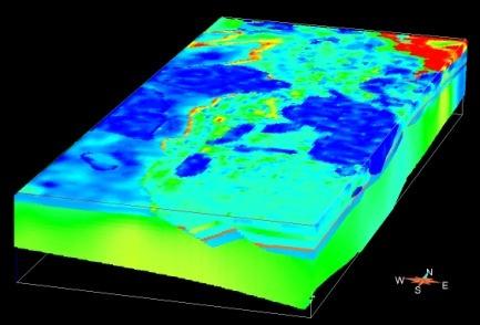
48 Stochastic inversion of gravity over a limestone (a) a prioridensity distribution (b) density histogram after inversion (c) inverted density distribution
49 Geostatistical constraints γ(h) Characteristic range, texture, & sill for each lithology Variography is litho-dependent, i.e. geological model based h Condition property changes to comply with geostatistical character


50 Stochastic simulation versus kriging Acoustic impedance models, controlled by seismic and wireline logs (Dubrule, 2003)

51 Acoustic impedance distributions (Lamy et al, 1998 [cited by Dubrule, 2003])

52 from inversion from mapping Linking info from petrophysics (after Dubrule, 2003)
 Permit changes to properties of cell, its lithotype, & its vertices Set of lithotypes fixed Lithotype map at")

53 Bosch inversion 2D example (c.f. 3DWEG) Permit changes to properties of cell, its lithotype, & its vertices Set of lithotypes fixed Lithotype map at Earth s surface is known/fixed Density & susceptibility honour prior distributions Multiple regions with same lithotype; volume fraction; area/perimeter? Stratigraphic constraints, e.g. olivine gabbro not permitted to make direct contact with anorthositic host rocks Example: Kiglapait, Labrador (after Bosch & McGaughey, 2001)

54 Interpret lithology from multiple data sets Mount Dore integrated interpretation, for Geological Survey of QLD Main components: AEM, gravity, magnetics, and geological mapping


55 Mount Dore inversion & inverted-lithology workflow geological block model susceptibility model inverted-lithology generalised density model detailed conductivity model
 are coincident with mapped")
56 Mount Dore inverted-lithology Inverted faciesand initial faciesagreed in 72% of cells. Regions reclassified by LogTransas Double Crossing Metamorphics(high density and high susceptibility) are coincident with mapped intrusiveswhich were not included in the original geological model.
57 Howmanyconstraints make a difference? It depends! Four examples: 2 constraints, huge impact 9 constraints, big impact Hundreds of constraints, modest relatively modest impact Integrated approach delivers utterly different interpretation


58 Constrained geometry inversion of TMI Elevation differences between inverted and original basement surfaces One drill hole constraint No constraints Two drill hole constraints
; basement starting value 10mS/m.")
59 Tempest survey line Bull Creek The starting model comprised cover (50m thick) over basement. Cover conductivity was initially 800mS/m (inferred from VPem1D homogeneous conductivity inversion); basement starting value 10mS/m. Procedure was depth-to-basement (geometry) inversion followed by heterogeneous conductivity inversion. Pierce points constraints not enforced at first. Tempest Data (Bx) 5000 E E E E Traverse flown over a discrete pyrrhotiterich zone. Cover thickness varies along the traverse Conductivity (ms/m)

60 Assess fit to drill hole pierce points after unconstrained geometry inversion. pierce points

61 Drill hole constrained inversion Take 1 Re-submit to conductivity inversion with contact adjusted locally to honour drill hole pierce points. Cover conductivity in the vicinity of drill holes now appears anomalous. Conclude that the assumed starting conductivity for cover may be too high depth to basement under-estimated. Re-run geometry + conductivity inversion sequence, with lower starting model conductivity in the cover (550mS/m c.f. 800mS/m), and honouring pierce points.

62 Drill hole constrained inversion Updated model consistent with drilling - more geologically plausible Drill hole depth-to-basement constraints provided additional control on the starting model conductivity. Drill hole constrained inversion suggests multiple layers within thicker cover Drill hole constrained NOT Drill hole constrained
 550 000 E 555 000 E 560 000 E 565 000 E Gridded image of the free air gravity data.")
63 Prominent Hill (South Australia) regional gravity N N Free Air (mgal) E E E E Gridded image of the free air gravity data. The geological model extents are shown in red.


64 Prominent Hill geological/density model Sections through the supplied density model. Model is very crude outside the core zone.

65 Prominent Hill (western extension) density model core-based density 3.3 g/cc iso-surface Perspective view of the density model after constrained gravity inversion. Shallow high density tongueaccounts for the western end of the Prominent Hill gravity anomaly. Drill hole trajectories shown in red.


66 Geologically-and petrophysically-constrained inversion of Boulia gravity, Queensland Pilgrim Fault Osborne 50km 0 65 mgal Free Air Gravity Image Illuminated from the NE
 overlying homogeneous basement (2.")

67 Unconstrained geometry inversion homogeneous cover (2.4 g/cc) overlying homogeneous basement (2.8 g/cc) basement contact horizontal initially at ~700m depth VE =20x Observed free air gravity data


68 Boulia methodology Compilation of available data Literature Search (Densities) Surface & basement Topo Gravity Data Common Earth Model Drill hole Data Geology after Mackey et al (2000)

69 Compare constrained and unconstrained results Unconstrained and constrained results are markedly different Gravity high = basement low after constraints applied Approxlocation of one of the basement intersecting holes X Red = basement surface after constrained inversion Green = basement surface after unconstrained inversion
70 Part 3 Opportunities & roadblocks
71 Opportunities faster processors in parallel deliver shorter run times massive amounts of memory facilitate inversion of larger/more detailed models lithological inversion efficient joint inversion by exploiting common geology incorporation of constraints from seismic contribute to resource modelling inversion software integrated with geological modelling packages inversion by geologists?
72 Roadblocks inversion still a black box? geological model construction and manipulation lack of petrophysical data time allocated for interpretation consultants and contractors at arms length? model appraisal and risk assessment upscaling workflows
73 1. Need for constraints Conclusions Immediate aim of inversion is to achieve an acceptable data fit, i.e. consistent with error Usually an infinite number models which are acceptable Need constraints to honour what is known and to reject conflicting models 2. Constrained inversion as a component of geological modelling: Inversion is a tool, to aid development/refinement of a geological model Advantages of inverting on a geological model: Flexibility/control in inversion, e.g. geometry inversion Driver for integration: constraints imposed naturally Capture geological domain attributes, e.g. remanence, stat. distributions
74 3. Types of constraints Hard/soft; real/artificial Conclusions cont d Wide range of geological constraint options, on geometry, structure, stratigraphy Options currently more limited for petrophysical constraints, but potential for lithology prediction and resource characterisation
75
76 Model appraisal Stochastic/probabilistic What if? experiments Extremal inversion Backus-Gilbert averaging Sensitivity analysis
77 Prominent Hill (main zone) density modelling Forward modelling of gravity revealed a mass deficit Selected drill holes, coloured by core density N N Section through density model based on core measurements Density (g/cc)

78 Prominent Hill constrained gravity inversion density model based on core measurements density model after constrained gravity inversion. N Density (g/cc) Inversion defines a diffuse haloaround the drilled/modelled volume
79 Extensive & shallow lower density source or compact & deep higher density source? Depth weighting Re-running the Prominent Hill gravity inversion with depth weighting revealed that the mass deficit couldbe explained by a deep root.
80 Appraisal of non-uniqueness via extremal inversion 1D horizontal loop FEM inversion Maximum Layer #4 conductivity Minimum Layer #4 conductivity Valid characterisation if layers are geologically meaningful (Fullagar& Oldenburg, 1984)
81 Max #1 Min #1 Conductance envelope after 1D extremalinversion of FEM Max #2 Min #2 Max #3 Max #4 Max #5 Min #5 Insensitive to number of layers (Fullagar& Oldenburg, 1984)
82 Backus-Gilbert averaging Any realisable data set has finite resolution 1D FEM window fn for depth 200m Create window functions for depths of interest Compute averages from acceptable model(s) Insensitive to number of layers 1D FEM window fn for depth 800m Trade-off between resolution and accuracy
83 Backus-Gilbert conductivity averages after 1D FEM inversion Averages are common to all linearly close models Deviation of extremal model averages from reference model averages (Fullagar& Oldenburg, 1984)

84 Sensitivity analysis An important source of nonuniqueness is loss of sensitivity with depth The depth of investigation (DOI) of a geophysical survey can be defined via successive inversions with different starting models Features common to all inversions can be considered to be reliable m 0 is the starting model resistivity (Oldenburg & Li, 1999)
 DOI index DOI index DOI index for M 0 =")
85 Depth of investigation (DOI) (Oldenburg & Li, 1999) DOI index DOI index DOI index for M 0 = 40/4000 Ωm
ERTH 4121 Gravity and Magnetic Exploration Session 8. Introduction to inversion - 2
 ERTH 4121 Gravity and Magnetic Exploration Session 8 Introduction to inversion - 2 Lecture schedule (subject to change) Minimum 10 x 3 hour lecture sessions: 1:30pm Tuesdays Aug 2 : 1. Introduction to
Mine Scale Constrained Geophysical Inversion; A Case Study at the Darlot-Centenary Gold Mine
 Page 1 Mine Scale Constrained Geophysical Inversion; A Case Study at the Darlot-Centenary Gold Mine Sarah Monoury, SRK Consulting, Ben Jupp, SRK Consulting and Andrew Foley, Gold Fields This article was
QUANTITATIVE INTERPRETATION
 QUANTITATIVE INTERPRETATION THE AIM OF QUANTITATIVE INTERPRETATION (QI) IS, THROUGH THE USE OF AMPLITUDE ANALYSIS, TO PREDICT LITHOLOGY AND FLUID CONTENT AWAY FROM THE WELL BORE This process should make
Integrated interpretation case study Bayanhongor Province, Mongolia
 Integrated interpretation case study Bayanhongor Province, Mongolia EARTH MODELLING 2014 MONTREAL, OCTOBER 20-22 Tim Chalke - Director, Asia Pacific Glenn Pears - Principal Geophysicist 2014 Mira Geoscience
Use of Geostatistically-constrained Potential Field Inversion and Downhole Drilling to Predict Distribution of Sulphide and Uranium Mineralisation
 Use of Geostatistically-constrained Potential Field Inversion and Downhole Drilling to Predict Distribution of Sulphide and Uranium Mineralisation Matthew Zengerer Talk Outline Introduction Purpose and
23855 Rock Physics Constraints on Seismic Inversion
 23855 Rock Physics Constraints on Seismic Inversion M. Sams* (Ikon Science Ltd) & D. Saussus (Ikon Science) SUMMARY Seismic data are bandlimited, offset limited and noisy. Consequently interpretation of
Quantitative Interpretation
 Quantitative Interpretation The aim of quantitative interpretation (QI) is, through the use of amplitude analysis, to predict lithology and fluid content away from the well bore. This process should make
Article: Report on gravity analysis
 Article: Report on gravity analysis Brownfields exploration using constrained gravity inversions By Chris Wijns (First Quantum Minerals Ltd) and Daniel Core (Fathom Geophysics LLC) Summary Gravity measurements
Reservoir connectivity uncertainty from stochastic seismic inversion Rémi Moyen* and Philippe M. Doyen (CGGVeritas)
") Rémi Moyen* and Philippe M. Doyen (CGGVeritas) Summary Static reservoir connectivity analysis is sometimes based on 3D facies or geobody models defined by combining well data and inverted seismic impedances.
Rémi Moyen* and Philippe M. Doyen (CGGVeritas) Summary Static reservoir connectivity analysis is sometimes based on 3D facies or geobody models defined by combining well data and inverted seismic impedances.
Constraining gravity and magnetic inversions for mineral exploration
 Constraining gravity and magnetic inversions for mineral exploration Nick Williams 1&2, Doug Oldenburg 1 & Peter Lelièvre 1 1 University of British Columbia Geophysical Inversion Facility 2 Geoscience
Rock physics integration of CSEM and seismic data: a case study based on the Luva gas field.
 Rock physics integration of CSEM and seismic data: a case study based on the Luva gas field. Peter Harris*, Zhijun Du, Harald H. Soleng, Lucy M. MacGregor, Wiebke Olsen, OHM-Rock Solid Images Summary It
C5 Magnetic exploration methods data analysis techniques
 C5 Magnetic exploration methods data analysis techniques C5.1 Data processing and corrections After magnetic field data have been collected a number of corrections are applied to simplify the interpretation.
Lithology-based model transform. Summary
 cdf( ) pdf( ) 3D lithological inversion of geophysical data Leif H. Cox*, Glenn A. Wilson, TechnoImaging, Michael S. Zhdanov, University of Utah and TechnoImaging, and Julian Vrbancich, Defense Science
Evaluation of Mineral Resource risk at a high grade underground gold mine
 Evaluation of Mineral Resource risk at a high grade underground gold mine Presented by: Aaron Meakin Manager Corporate Services CSA Global 21 August 2015 Project Background Beaconsfield Gold Mine, Tasmania
INTEGRATION OF BOREHOLE DATA IN GEOPHYSICAL INVERSION USING FUZZY CLUSTERING
 INTEGRATION OF BOREHOLE DATA IN GEHYSICAL INVERSION USING FUZZY CLUSTERING 1 st Duy Thong Kieu* 2 nd Anton Kepic Curtin University and DET CRC Curtin University and DET CRC Technology Park West Precinct
FALCON AGG inversion to constrain 3D geological models in the Glyde Sub-Basin, Northern Territory
 FALCON AGG inversion to constrain 3D geological models in the Glyde Sub-Basin, Northern Territory Peter Kovac 1, Luke Titus 2, Carlos Cevallos 3, Josh Bluett 2, Fabio Vergara 3 1 CGG GravMag Solutions,
Next Generation 3D Modelling & Inversion:
 Next Generation 3D Modelling & Inversion: what you don't know can help you Mark Jessell CET UWA Laurent Aillères (Monash Uni) Eric de Kemp (Geol. Survey Canada) Roland Martin (CNRS Toulouse) Mark Lindsay,
3D quantitative mineral potential targeting in the Kristineberg mining area, Sweden
 3D quantitative mineral potential targeting in the Kristineberg mining area, Sweden Tobias Hermansson, PhD Structural Geology Specialist Field Exploration North Fennoscandia Boliden Mines Outline Introduction
3D potential-field inversions and alteration mapping in the Gawler Craton and Curnamona Province, South Australia
 3D potential-field inversions and alteration mapping in the Gawler Craton and Curnamona Province, South Australia Richard Chopping, Nick Williams, Tony Meixner and Indrajit Roy Outline Inversions Introduction
AGM Presentation 6 November 2012
 AGM Presentation 6 November 2012 November 2012 Disclaimer Exploration Results and Mineral Resources The information in this report that relates to Exploration Results, Exploration Targets, Mineral Resources
Novel approach to joint 3D inversion of EM and potential field data using Gramian constraints
 first break volume 34, April 2016 special topic Novel approach to joint 3D inversion of EM and potential field data using Gramian constraints Michael S. Zhdanov 1,2, Yue Zhu 2, Masashi Endo 1 and Yuri
COPYRIGHT and DISCLAIMER Copyright in the material in this presentation is owned by Consolidated Minerals Pty Ltd and the material
 Consolidated Minerals Limited ( CML ) is an independent private company incorporated in Jersey. CML is a manganese and chromite ore producer with operations in Australia and Ghana, complemented by a trading-
Geophysics foundations: Seeing underground: Introduction
 Introduction Outline This five page article was written for those involved in the earth sciences who have no background in geophysics. It is intended to explain very briefly how applied geophysics can
Quantitative Seismic Interpretation An Earth Modeling Perspective
 Quantitative Seismic Interpretation An Earth Modeling Perspective Damien Thenin*, RPS, Calgary, AB, Canada TheninD@rpsgroup.com Ron Larson, RPS, Calgary, AB, Canada LarsonR@rpsgroup.com Summary Earth models
MEMORANDUM. Al Maynard, Francesco Fucilla - Yellow Resources Pty. Ltd. Lake Darlot - Gravity and Passive Seismic Processing Interpretation/Modelling
 Southern Geoscience Consultants Pty Ltd ACN 067 552 461 Level 1, 183 Great Eastern Highway, Belmont WA 6104 AUSTRALIA PO Box 694, Belmont WA 6984 AUSTRALIA T +61 (8) 6254 5000 F +61 (8) 6254 5099 E geophysics@sgc.com.au
Accurate reservoir modelling through optimized integration of geostatistical inversion and flow simulation. A North Sea case study.
 Accurate reservoir modelling through optimized integration of geostatistical inversion and flow simulation. A North Sea case study. A. Castoro 1, L de Groot 2, D. Forsyth 3 & R. Maguire 1 1 Fugro-Jason
Man, Machine and Data: A Mineral Exploration Perspective
 Man, Machine and Data: A Mineral Exploration Perspective Eun-Jung Holden, Geodata Algorithms Team The Centre for Exploration Targeting, School of Earth Sciences The University of Western Australia Team
Application and Challenges of Artificial Intelligence in Exploration
 Application and Challenges of Artificial Intelligence in Exploration XPLOR 2017 John McGaughey 2017 Mira Geoscience Ltd. Artificial Intelligence Artificial Intelligence is colossally hyped these days,
For personal use only
 Citadel Project LandTEM Electromagnetic Survey Detailed Update No. 1 Magnum Unlocked Corker Unearthed Highlights The LandTEM electromagnetic survey showed the Magnum Deposit to have a significant electromagnetic
OZ SEEBASE TM. Datasets. Digital Elevation Model
 Digital Elevation Model 10 Digital Elevation Models (DEM s) often show the youngest structures, and any active geological structures. They are widely used for neotectonic analysis. The composition of eroding
Darnley Bay Resources Preliminary Airborne Survey Results
 4 King Street West, Suite 1103 Toronto, Ontario M5H 1B6, Canada Tel:(416) 862-7885 Fax:(416) 862-7889 dbr@darnleybay.com UPDATE Trading Symbol: DBL. TSX Venture Exchange April 19, 2010 Darnley Bay Resources
Update on the Big Easy Gold Project, Newfoundland
 Update on the Big Easy Gold Project, Newfoundland FORWARD-LOOKING STATEMENTS Certain information contained herein regarding Cartier Iron Corporation, including management s assessment of future plans and
3D Geometry of the Xade Complex inferred from Gravity and Magnetic Data
 Geophysical Case Histories 3D Geometry of the Xade Complex inferred from Gravity and Magnetic Data 1. British Geological Survey, Edinburgh, United Kingdom Paper 92 Pouliquen, G. [1], Key, R. [1] ABSTRACT
PETROLEUM GEOSCIENCES GEOLOGY OR GEOPHYSICS MAJOR
 PETROLEUM GEOSCIENCES GEOLOGY OR GEOPHYSICS MAJOR APPLIED GRADUATE STUDIES Geology Geophysics GEO1 Introduction to the petroleum geosciences GEO2 Seismic methods GEO3 Multi-scale geological analysis GEO4
In The Shadow of a Headframe: Deep Exploration Using Integrated 3-D Seismic and BHEM Aat The Louvicourt Mine, Quebec
 Geophysical Case Histories In The Shadow of a Headframe: Deep Exploration Using Integrated 3-D Seismic and BHEM Aat The Louvicourt Mine, Quebec 1. SEISServ, Quebec City, Quebec, Canada 2. Geoserve Logging
AGM Presentation 12 November 2013
 AGM Presentation 12 November 2013 Disclaimer Exploration Results and Mineral Resources The information in this report that relates to Exploration Results, Exploration Targets, Mineral Resources or Ore
Multiple horizons mapping: A better approach for maximizing the value of seismic data
 Multiple horizons mapping: A better approach for maximizing the value of seismic data Das Ujjal Kumar *, SG(S) ONGC Ltd., New Delhi, Deputed in Ministry of Petroleum and Natural Gas, Govt. of India Email:
Statistical Rock Physics
 Statistical - Introduction Book review 3.1-3.3 Min Sun March. 13, 2009 Outline. What is Statistical. Why we need Statistical. How Statistical works Statistical Rock physics Information theory Statistics
A review of the large Red Dragon prospect was completed following the 2011 field season, the
 ASX / MEDIA RELEASE ST GEORGE MINING LIMITED ASX: SGQ ACN 139 308 973 Level 1, 115 Cambridge Street PO Box 1305, West Leederville WA 6007 www.stgeorgemining.com.au Phone +618 9322 6600 Facsimile +618 9322
COMMANDER RESOURCES LTD SOUTH VOISEY S BAY NI-CU-CO PROJECT LABRADOR
 COMMANDER RESOURCES LTD SOUTH VOISEY S BAY NI-CU-CO PROJECT LABRADOR May 2017 CORPORATE DISCLOSURE Disclaimer The information contained herein, while obtained from sources which we believe are reliable,
Using seismic guided EM inversion to explore a complex geological area: An application to the Kraken and Bressay heavy oil discoveries, North Sea
 Using seismic guided EM inversion to explore a complex geological area: An application to the Kraken and Bressay heavy oil discoveries, North Sea Zhijun Du*, PGS Summary The integrated analysis of controlled
Seismic validation of reservoir simulation using a shared earth model
 Seismic validation of reservoir simulation using a shared earth model D.E. Gawith & P.A. Gutteridge BPExploration, Chertsey Road, Sunbury-on-Thames, TW16 7LN, UK ABSTRACT: This paper concerns an example
High Resolution Seismic for Minerals
 High Resolution Seismic for Minerals Greg Turner HiSeis Pty Ltd MEGWA April 2013 WELCOME HiSeis Pty Ltd, Suite 4 Enterprise Unit 3, 9 DeLaeter Way, Bentley, WA 6102 Ph: +61 8 9470 9866 www.hiseis.com Used
Mo AEM 05 Geo-steered 3D Inversion of Airborne Electromagnetic Data in Rugged Terrain
 Mo AEM 05 Geo-steered 3D Inversion of Airborne Electromagnetic Data in Rugged Terrain C. Scholl* (CGG), J. Neumann (CGG) & M.D. Watts (CGG) SUMMARY Multidimensional inversions for electromagnetic (EM)
Integrated interpretation of multimodal geophysical data for exploration of geothermal resources Case study: Yamagawa geothermal field in Japan
 Integrated interpretation of multimodal geophysical data for exploration of geothermal resources Case study: Yamagawa geothermal field in Japan Masashi Endo*(TechnoImaging), Alex Gribenko (TechnoImaging
Constrained inversion of gravity and magnetic data: a real time exploration tool?
 Constrained inversion of gravity and magnetic data: a real time exploration tool? Hugh Miller Michael R. sh Michael Wheeler Colin G. Farquharson Department of Earth Sciences Memorial University of ewfoundland,
Porosity. Downloaded 09/22/16 to Redistribution subject to SEG license or copyright; see Terms of Use at
 Geostatistical Reservoir Characterization of Deepwater Channel, Offshore Malaysia Trisakti Kurniawan* and Jahan Zeb, Petronas Carigali Sdn Bhd, Jimmy Ting and Lee Chung Shen, CGG Summary A quantitative
Background. Developing a FracMan DFN Model. Fractures, FracMan and Fragmentation Applications of DFN Models to Block & Panel Caving
 Background Golder Associates are one of the pioneering groups in the use of the Discrete Fracture Network (DFN) approach. DFN models seek to describe the heterogeneous nature of fractured rock masses by
Downloaded 10/02/18 to Redistribution subject to SEG license or copyright; see Terms of Use at
 Multi-scenario, multi-realization seismic inversion for probabilistic seismic reservoir characterization Kester Waters* and Michael Kemper, Ikon Science Ltd. Summary We propose a two tiered inversion strategy
Case study: Integration of REFLEX iogas and an Olympus PXRF analyzer with Leapfrog Geo for advanced dynamic modelling and better decision making
 LEAPFROG GEO Case study: Integration of REFLEX iogas and an Olympus PXRF analyzer with Leapfrog Geo for advanced dynamic modelling and better decision making FIRST QUANTUM MINERALS LTD KEVITSA NI-CU-PT-PD
Applications of geophysical inversions in mineral exploration
 Applications of geophysical inversions in mineral exploration I DOUGLAS W. OLDENBURG, YAOGUO LI, and COLIN G. FARQUHARSON, University of British Columbia PETER KOWALCZYK, Placer Dome, Incorporated, Vancouver,
ACQUISITION OF THE MCCLEERY COPPER-COBALT PROJECT, CANADA
 ACQUISITION OF THE MCCLEERY COPPER-COBALT PROJECT, CANADA HIGHLIGHTS New claims staked covering ~9km 2 to secure a 100% interest in the McCleery Copper-Cobalt Project in the Yukon Territory, Canada ABN
Oil and Natural Gas Corporation Ltd., VRC(Panvel), WOB, ONGC, Mumbai. 1
, WOB, ONGC, Mumbai. 1") P-259 Summary Data for identification of Porosity Behaviour in Oligocene Lime Stone of D18 Area Of Western Offshore, India V.K. Baid*, P.H. Rao, P.S. Basak, Ravi Kant, V. Vairavan 1, K.M. Sundaram 1, ONGC
P-259 Summary Data for identification of Porosity Behaviour in Oligocene Lime Stone of D18 Area Of Western Offshore, India V.K. Baid*, P.H. Rao, P.S. Basak, Ravi Kant, V. Vairavan 1, K.M. Sundaram 1, ONGC
Joint Interpretation of Magnetotelluric and Seismic Models for Exploration of the Gross Schoenebeck Geothermal Site
 Joint Interpretation of Magnetotelluric and Seismic Models for Exploration of the Gross Schoenebeck Geothermal Site G. Muñoz, K. Bauer, I. Moeck, O. Ritter GFZ Deutsches GeoForschungsZentrum Introduction
Enhanced Subsurface Interpolation by Geological Cross-Sections by SangGi Hwang, PaiChai University, Korea
 Enhanced Subsurface Interpolation by Geological Cross-Sections by SangGi Hwang, PaiChai University, Korea Abstract Subsurface geological structures, such as bedding, fault planes and ore body, are disturbed
SEG Houston 2009 International Exposition and Annual Meeting
 The role of EM rock physics and seismic data in integrated 3D CSEM data analysis I. Brevik*, StatoilHydro, Pål T. Gabrielsen, Vestfonna and Jan Petter Morten, EMGS Summary An extensive 3D CSEM dataset
MINERAL EXPLORATION UNDER DEEP COVER. Neil Williams School of Earth & Environmental Sciences
 MINERAL EXPLORATION UNDER DEEP COVER Neil Williams School of Earth & Environmental Sciences The problem Discovery rates, especially of world-class deposits, have fallen significantly over the past 15-20
Geotechnical modelling based on geophysical logging data
 University of Wollongong Research Online Coal Operators' Conference Faculty of Engineering and Information Sciences 2013 Geotechnical modelling based on geophysical logging data Peter Hatherly Coalbed
Optimizing Geophysical Inversions for Archean Orogenic Gold Settings
 Geophysical Inversion and Modeling Optimizing Geophysical Inversions for Archean Orogenic Gold Settings 1. University of British Columbia Paper 103 Mitchinson, D. E. [1], Phillips, N. D. [1] ABSTRACT Geophysical
Petroleum Exploration
 Petroleum Exploration Upstream Petroleum Exploration The role of exploration is to provide the information required to exploit the best opportunities presented in the choice of areas, and to manage research
For personal use only
 20 7 APRIL JANUARY 2017 2017 ASX ASX ANNOUNCEMENT QUEENSLAND EXPLORATION PROJECTS UPDATE Projects identified by Sasak through analysis of regional geophysics and geochemistry databases to target IOCG (Iron
Recent developments in object modelling opens new era for characterization of fluvial reservoirs
 Recent developments in object modelling opens new era for characterization of fluvial reservoirs Markus L. Vevle 1*, Arne Skorstad 1 and Julie Vonnet 1 present and discuss different techniques applied
Estimation of Cole-Cole parameters from time-domain electromagnetic data Laurens Beran and Douglas Oldenburg, University of British Columbia.
 Estimation of Cole-Cole parameters from time-domain electromagnetic data Laurens Beran and Douglas Oldenburg, University of British Columbia. SUMMARY We present algorithms for the inversion of time-domain
Yukon Presentation. October 2012
 Yukon Presentation October 2012 Disclaimer This presentation contains forward looking statements. All statements, other than statements of historical fact, included herein, including without limitation,
Magnetic Case Study: Raglan Mine Laura Davis May 24, 2006
 Magnetic Case Study: Raglan Mine Laura Davis May 24, 2006 Research Objectives The objective of this study was to test the tools available in EMIGMA (PetRos Eikon) for their utility in analyzing magnetic
2017 Fowler Domain & Western Gawler Craton SkyTEM 312 AEM Survey, South Australia
 2017 Fowler Domain & Western Gawler Craton SkyTEM 312 AEM Survey, South Australia Geoscience Australia & the Geological Survey of South Australia D.J McInnes Geoscience Australia ecat ID 121550 Department
Seismic Attributes and Their Applications in Seismic Geomorphology
 Academic article Seismic Attributes and Their Applications in Seismic Geomorphology Sanhasuk Koson, Piyaphong Chenrai* and Montri Choowong Department of Geology, Faculty of Science, Chulalongkorn University,
Inversion of AEM data at a survey scale utilising new inversion solver and forward model
 Inversion of AEM data at a survey scale utilising new inversion solver and forward model Jovan Silic (), Rod Paterson (Intrepid Geophysics), Des FitzGerald (Intrepid Geophysics), Outline: Describe the
Auxiliary Information in Geophysical Inversion
 Auxiliary Information in Geophysical Inversion Robert G. Ellis 1, Peter A. Diorio 2, Ian N. MacLeod 1 Abstract There are a number of critical auxiliary inputs to a geophysical inversion, apart from the
RESERVOIR SEISMIC CHARACTERISATION OF THIN SANDS IN WEST SYBERIA
 www.senergyltd.com RESERVOIR SEISMIC CHARACTERISATION OF THIN SANDS IN WEST SYBERIA Erick Alvarez, Jaume Hernandez, Bolkhotivin E.A., Belov A.V., Hakima Ben Meradi,Jonathan Hall, Olivier Siccardi, Phil
Building an Integrated Static Reservoir Model 5-day Course
 Building an Integrated Static Reservoir Model 5-day Course Prepared by International Reservoir Technologies Lakewood, Colorado http://www.irt-inc.com/ 1 Agenda Day 1 Day 2 Day 3 Day 4 Day 5 Morning Introduction
BUILDING 3D MODEL OF ROCK QUALITY DESIGNATION ASSISTED BY CO-OPERATIVE INVERSION OF SEISMIC AND BOREHOLE DATA
 BUILDING 3D MODEL OF ROCK QUALITY DESIGNATION ASSISTED BY CO-OPERATIVE INVERSION OF SEISMIC AND BOREHOLE DATA 1 st Duy Thong Kieu 2 nd Anton Kepic* Curtin University and DET CRC Curtin University and DET
C031 Quantifying Structural Uncertainty in Anisotropic Depth Imaging - Gulf of Mexico Case Study
 C031 Quantifying Structural Uncertainty in Anisotropic Depth Imaging - Gulf of Mexico Case Study K. Osypov* (WesternGeco), D. Nichols (WesternGeco), Y. Yang (WesternGeco), F. Qiao (WesternGeco), M. O'Briain
J.V. Herwanger* (Ikon Science), A. Bottrill (Ikon Science) & P. Popov (Ikon Science)
, A. Bottrill (Ikon Science) & P. Popov (Ikon Science)") 29829. One 4D geomechanical model and its many applications J.V. Herwanger* (Ikon Science), A. Bottrill (Ikon Science) & P. Popov (Ikon Science) Main objectives (i) Field case study demonstrating application
29829. One 4D geomechanical model and its many applications J.V. Herwanger* (Ikon Science), A. Bottrill (Ikon Science) & P. Popov (Ikon Science) Main objectives (i) Field case study demonstrating application
Potential Field investigation of Williston Basin Basement
 Potential Field investigation of Williston Basin Basement Jiakang Li* and Igor Morozov, University of Saskatchewan, Canada Summary Major faults and domains are identified in the Precambrian basement of
SUMMARY METHODOLOGY. 1 + (1 η)(ıωτ) c
(ıωτ) c") On recovering induced polarization information from airborne time domain EM data Seogi Kang, Douglas W. Oldenburg, Dikun Yang, David Marchant, Geophysical Inversion Facility, University of British Columbia
On recovering induced polarization information from airborne time domain EM data Seogi Kang, Douglas W. Oldenburg, Dikun Yang, David Marchant, Geophysical Inversion Facility, University of British Columbia
Technical Note: Coloured, Deterministic & Stochastic Inversion
 Technical Note: Coloured, Deterministic & Stochastic Inversion http://www.sorviodvnvm.co.uk 1 Earthworks Ltd - Company Overview Earthworks Environment & Resources Ltd. was formed in June 2001 to provide
Towed Streamer EM data from Barents Sea, Norway
 Towed Streamer EM data from Barents Sea, Norway Anwar Bhuiyan*, Eivind Vesterås and Allan McKay, PGS Summary The measured Towed Streamer EM data from a survey in the Barents Sea, undertaken in the Norwegian
Summary. Introduction
 Noel Black*, Glenn A. Wilson, TechnoImaging, Alexander V. Gribenko and Michael S. Zhdanov, TechnoImaging and The University of Utah Summary Recent studies have inferred the feasibility of time-lapse controlled-source
KEMESS SOUTH MAGNETIC MODELING. CONDOR CONSULTING, INC. OCTOBER 2017
 KEMESS SOUTH MAGNETIC MODELING. CONDOR CONSULTING, INC. OCTOBER 2017 INTRODUCTION Magnetic data in the vicinity of the Kemess South Mine in the Yukon has been analyzed and modeled in order to try to explain
Combining geological surface data and geostatistical model for Enhanced Subsurface geological model
 Combining geological surface data and geostatistical model for Enhanced Subsurface geological model M. Kurniawan Alfadli, Nanda Natasia, Iyan Haryanto Faculty of Geological Engineering Jalan Raya Bandung
Update on Dargues Gold Mine and future exploration plans Mining NSW Conference
 Update on Dargues Gold Mine and future exploration plans Mining NSW Conference 27 August 2014 Unity Mining Limited Disclaimer This presentation has been prepared by Unity Mining Limited ( Company ). The
NEW GEOLOGIC GRIDS FOR ROBUST GEOSTATISTICAL MODELING OF HYDROCARBON RESERVOIRS
 FOR ROBUST GEOSTATISTICAL MODELING OF HYDROCARBON RESERVOIRS EMMANUEL GRINGARTEN, BURC ARPAT, STANISLAS JAYR and JEAN- LAURENT MALLET Paradigm Houston, USA. ABSTRACT Geostatistical modeling of reservoir
The SPE Foundation through member donations and a contribution from Offshore Europe
 Primary funding is provided by The SPE Foundation through member donations and a contribution from Offshore Europe The Society is grateful to those companies that allow their professionals to serve as
Namibia Rare Earths Inc. Mobilizes for Airborne Survey Over Kunene Cobalt-Copper Project as Exploration Ramps Up
 Press Release Namibia Rare Earths Inc. Mobilizes for Airborne Survey Over Kunene Cobalt-Copper Project as Exploration Ramps Up Detailed airborne electromagnetic and magnetic survey comprising 3,700 line
For personal use only
 Limited ASX code: RNU The Eastern Eyre Copper Project Presented at the South Australian Resources and Energy Investment Conference Adelaide, 14 April 2015 David Christensen, Managing Director 1 Eastern
Richard Poulden, Executive Chairman of Wishbone Gold said:
 Wishbone Gold Plc / Index: AIM / Epic: WSBN / Sector: Natural Resources 17 July 2013 Wishbone Gold Plc ( Wishbone Gold or the Company ) Positive Exploration Update on Hanging Valley Prospect, Wishbone
Alligator commences drilling of TCC4 uranium prospect in Arnhem Land, NT 4 September 2018
 Alligator commences drilling of TCC4 uranium prospect in Arnhem Land, NT 4 September 2018 Highlights The TCC4 prospect represents Alligators most advanced untested undercover uranium target with a large
MT Prospecting. Map Resistivity. Determine Formations. Determine Structure. Targeted Drilling
 MT Prospecting Map Resistivity Determine Formations Determine Structure Targeted Drilling Cross-sectional interpretation before and after an MT survey of a mineral exploration prospect containing volcanic
NOTES ON THE RESPONSE OF THE PECORS MAGNETIC ANOMALY
 L.E. Reed Geophysical Consultant Inc. 11331 Fourth Line Nassagaweya R.R. 2 Rockwood, Ont. N0B 2K0, Canada PHONE:905 854 0438 FAX: 905 854 1355 E-mail: lereed@aztec-net.com NOTES ON THE RESPONSE OF THE
POTASH DRAGON CHILE GEOPHYSICAL SURVEY TRANSIENT ELECTROMAGNETIC (TEM) METHOD. LLAMARA and SOLIDA PROJECTS SALAR DE LLAMARA, IQUIQUE, REGION I, CHILE
 METHOD. LLAMARA and SOLIDA PROJECTS SALAR DE LLAMARA, IQUIQUE, REGION I, CHILE") POTASH DRAGON CHILE GEOPHYSICAL SURVEY TRANSIENT ELECTROMAGNETIC (TEM) METHOD LLAMARA and SOLIDA PROJECTS SALAR DE LLAMARA, IQUIQUE, REGION I, CHILE OCTOBER 2012 CONTENT Page I INTRODUCTION 1 II FIELD
POTASH DRAGON CHILE GEOPHYSICAL SURVEY TRANSIENT ELECTROMAGNETIC (TEM) METHOD LLAMARA and SOLIDA PROJECTS SALAR DE LLAMARA, IQUIQUE, REGION I, CHILE OCTOBER 2012 CONTENT Page I INTRODUCTION 1 II FIELD
Best Practice Reservoir Characterization for the Alberta Oil Sands
 Best Practice Reservoir Characterization for the Alberta Oil Sands Jason A. McLennan and Clayton V. Deutsch Centre for Computational Geostatistics (CCG) Department of Civil and Environmental Engineering
Ramping-up Exploration Value from Aeromagnetic Surveys - More Geological Input Needed!
 Ramping-up Exploration Value from Aeromagnetic Surveys - More Geological Input Needed! Dave Isles Southern Geoscience Consultants AIG Geoscientists Symposia Bali May 2013 EAST ASIA: Geology, Exploration
Mountain Maid Gold System Displays Major Size Potential
 29 July 2008 The Manager, Companies Australian Securities Exchange Ltd Electronic Announcement System Dear Sir, AXIOM MINING LIMITED (ASX CODE: AVQ) ASX Announcement Mountain Maid Gold System Displays
Simultaneous Inversion of Clastic Zubair Reservoir: Case Study from Sabiriyah Field, North Kuwait
 Simultaneous Inversion of Clastic Zubair Reservoir: Case Study from Sabiriyah Field, North Kuwait Osman Khaled, Yousef Al-Zuabi, Hameed Shereef Summary The zone under study is Zubair formation of Cretaceous
Reservoir Characterization using AVO and Seismic Inversion Techniques
 P-205 Reservoir Characterization using AVO and Summary *Abhinav Kumar Dubey, IIT Kharagpur Reservoir characterization is one of the most important components of seismic data interpretation. Conventional
Kurt Marfurt Arnaud Huck THE ADVANCED SEISMIC ATTRIBUTES ANALYSIS
 The Society of Exploration Geophysicists and GeoNeurale announce Kurt Marfurt Arnaud Huck THE ADVANCED SEISMIC ATTRIBUTES ANALYSIS 3D Seismic Attributes for Prospect Identification and Reservoir Characterization
CHAPTER FOUR GEOPHYSICAL INTERPRETATION AND DISCUSSION
 CHAPTER FOUR GEOPHYSICAL INTERPRETATION AND DISCUSSION 4.1. DATA PROCESSING AND INTERPRETATION 4.1.1. Introduction Processing of potential field data entails the application of various filters to the data
Geostatistical Determination of Production Uncertainty: Application to Pogo Gold Project
 Geostatistical Determination of Production Uncertainty: Application to Pogo Gold Project Jason A. McLennan 1, Clayton V. Deutsch 1, Jack DiMarchi 2 and Peter Rolley 2 1 University of Alberta 2 Teck Cominco
4D stress sensitivity of dry rock frame moduli: constraints from geomechanical integration
 Title 4D stress sensitivity of dry rock frame moduli: constraints from geomechanical integration Authors Bloomer, D., Ikon Science Asia Pacific Reynolds, S., Ikon Science Asia Pacific Pavlova, M., Origin