THE ABDUS SALAM INTERNATIONAL CENTRE FOR THEORETICAL PHYSICS
|
|
|
- Allan Harvey
- 5 years ago
- Views:
Transcription
1 Available at: IC/2006/040 United Nations Educational Scientific and Cultural Organization and International Atomic Energy Agency THE ABDUS SALAM INTERNATIONAL CENTRE FOR THEORETICAL PHYSICS H/V SPECTRAL RATIOS TECHNIQUE APPLICATION IN THE CITY OF BUCHAREST: CAN WE GET RID OF SOURCE EFFECT? B. Grecu, M. Radulian, N. Mandrescu National Institute for Earth Physics, Bucharest, Magurele, Romania and G.F. Panza Department of Earth Sciences, University of Trieste, Trieste, Italy and The Abdus Salam International Centre for Theoretical Physics, SAND Group, Trieste, Italy. MIRAMARE TRIESTE June 2006
2 Abstract The main issue of this paper is to show that, contrary to many examples of monitored strong earthquakes in different urban areas, the intensity and spectral characteristics of the strong ground motion induced in the Bucharest area, by Vrancea intermediate-depth earthquakes, is controlled by the coupled source-site properties rather than by the local site conditions alone. Our results have important implications on the strategy to follow when assessing the seismic microzoning for Bucharest city: we recommend the application of deterministic approaches rather than empirical techniques, like H/V spectral ratios. However, when applied to noise data, the H/V spectral technique succeeds in reproducing the predominant frequency response characteristic for the sedimentary cover beneath the city and the relatively uniform distribution of this structure over the city area. Our results strongly disagree with any strategy of extrapolation from small and moderate earthquakes to strong earthquakes for microzoning purposes. 1
3 Introduction Although situated relatively far away from the Vrancea seismic source (a peculiar intermediate-depth nest of earthquakes, located in a narrow volume beneath South-Eastern Carpathians, in Romania), the Bucharest metropolitan area is one of the most vulnerable urban areas in the World at the earthquake impact. For example, the earthquake of 4 March 1977 (M w = 7.4), occurred in Vrancea seismic source at 94 km of depth and at 170 km epicentral distance from Bucharest caused, in the town, the collapse of 32 buildings of 8-12 storeys, while about 150 old buildings of 6-9 storeys were strongly damaged, many of them requiring subsequent demolition. The collapse of the tall buildings was, initially, attributed to the coincidence of their fundamental period of free vibration (1-1.5 s) with the period of resonance of the entire succession of the Quaternary unconsolidated deposits, underlying the Bucharest urban area, excited by the seismic motion generated by the Vrancea shock. At present, the debate among seismologists and civil engineers about which of the two key factors, source or surface geology, prevails in controlling the ground motion intensity in Bucharest area is still open. Certainly, an answer based on ground motion computation using physical laws rather than empirical techniques, like H/V spectral ratios or array techniques, based on noise or small earthquake analysis, would be preferable, also on account of the possible non-linear behaviour of the unconsolidated (clay) deposits that can explain the variability of the site amplification functions when considering weak- and strong-motion records [24]. However, the computation of the complete wavefield requires a priori knowledge of a complex system of parameters which makes this task, in general, very difficult. Most of the studies focused on the seismic microzonation of Bucharest (e.g. [5], [23]) are based on the key hypothesis that has not yet reached a general scientific consensus (e.g. [1], [2], [10], [21], [26]): microseismic noise and moderate-to-low seismicity is satisfactorily 2
4 representative of the site response characteristics expected for the large earthquakes. Though based on rather simple source and structure modelling, the numerical simulation of the strong ground motion in Bucharest for Vrancea earthquakes by deterministic approach ([16], [17], [18]) drew attention on the crucial role played by the particular source-path pattern: the modelling showed that the ground motion characteristics can strongly vary with changing source parameters, even if the geometry and physical properties of the medium between the focus and the site remain practically the same. The proper answer to the question are site amplification effects really the only features controlling strong ground motion records in Bucharest? is crucial for the sound seismic microzonation of the town, since the cheap approaches, based on the empirical analysis of easily accessible ambient noise recordings (H/V spectral ratios technique, array techniques), are generally preferred to the more complex approaches based on numerical simulation of the expected ground motion. The purpose of the present paper is to check the validity and relevance of the H/V spectral ratios technique in the particular case of the Bucharest area. This endeavour is essential and imperative since considerable efforts have recently been made to solve the problem of microzonation in Bucharest using a large data set of noise and moderate-to-low seismicity records obtained from 32 broadband stations that operated for 9 months within the Urban Seismology experiment ([22]). As we shall demonstrate, in the case of Bucharest city, the H/V spectral ratios analysis is irrelevant without a careful interpretation of what we know about strong ground motion (observed and modelled) characteristics. Local structure setting Bucharest city (Fig. 1) is situated in the Romanian Plain, along the roughly parallel valleys of Dambovita and Colentina rivers. From the geological point of view, the town is 3
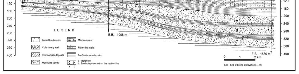
5 located in the central part of the Moesian Platform, at an average epicentral distance of 160 km from the Vrancea region. Topographically the city is built on a plain slightly dipping towards southeast, following the direction of the Dambovita and Colentina rivers, which divides the city into several morphological units (Fig. 2): Dambovita Colentina interstream, Baneasa-Pantelimon Plain, Cotroceni-Vacaresti Plain, and the meadows along the abovementioned rivers. The hydrostatic level ranges between 1 and 5 m in Dambovita and Colentina meadows, between 5 and 10 m in the Dambovita Colentina interstream, and below 10 m in the Cotroceni Vacaresti and Baneasa Pantelimon plains. Lithological information has been compiled from geological, geotechnical and hydrogeological boreholes. The synthesis of the geological data available for Bucharest area was firstly presented by Liteanu ([11]) and then by others, e.g., Mândrescu and Radulian ([14]), Lungu et al. ([12]). The lithological succession from the bottom upwards for the Lower and Upper Quaternary deposits ([15]) is characterized by the so-called Frăteşti layers, overlaid by marl complex and finally the Mostiştea sands. The Frăteşti complex consists of three layers of sand and gravel, designed as A (upper layer), B (middle layer) and C (lower layer), separated by two intercalated layers of clay (Fig. 3). The layers have a similar structure, with coarse sands and gravel at the bottom, and medium-fine sands transforming gradually to clays in the upper part. The entire complex is gently dipping from south to north and becomes thicker along the same direction (Fig. 3). The next structural unit of the sedimentary deposit, overlying the Frăteşti layers, is the marl complex, represented through a succession of marl and clay, sometimes sandy marl with intercalation of fine sands (Middle Pleistocene). The rocks composing the marl complex correspond from the granulometric point of view to some lacustrine formations, placed beneath shallow facies in which the determinant material was represented by pelitic fraction. The marl complex has a thickness of m with an average velocity of S-wave of
6 km/s. The complex undergoes a slight descend from south to north, accompanied by an increase of the deposits thickness in the same direction (Fig. 3). The upper part of the marl complex is continuously covered by a bank of sands (Mostiştea sands) with a general thickness of m (Upper Pleistocene). The average velocity of S-wave propagation is between and km/s. The complete succession of Pliocene and Quaternary deposits until the top of the Upper Pleistocene shows that the whole region was affected permanently by negative vertical movements. The predominant periods of oscillation, T, of the subsurface layers over Bucharest territory, computed introducing in the simple relation T=4h/β, where β is the S- wave velocity and h the layer thickness, the available borehole data range between 1.0 and 1.9 s, and increase from south to north, as a consequence of the constant increase of the thickness of the Quaternary cohesionless deposits ([13], [15]). Application of H/V spectral ratios technique An experiment of recording seismic noise deployed 16 recording sites in the Bucharest area, starting September until November in 1997 ([5]). At each site, the signal has been recorded with three-component 2-Hz Mark Products velocity sensors for at least 30 minutes. The sites were selected to be adjacent to boreholes with drilling reaching the bedrock, i.e. to sites with precisely known thickness of the sedimentary cover. Recently, within the URS (Urban Seismology) project, carried out by the Collaborative Research Center 461 Strong Earthquakes of Karlsruhe University and the National Institute for Earth Physics of Bucharest, 32 broadband stations operated between October 2003 and August 2004 ([22]). The full processing of the impressive data set collected during the experiment is presently in progress. 5
7 The application of Nakamura s technique ([19] to estimate H/V spectral ratios from the data of 1997 experiment shows that with the exception of one site, the predominant peak is relatively stable within the period in the range from 1 to 2 seconds, with an average of 1.4 s, interpreted as a broad and stable soil resonance. In the simple horizontal layer resonance interpretation (T=4h/β), a resonance peak around 1.4 s could correspond to a ~ 120 m thick layer of unconsolidated sediments, with a shear wave velocity Vs ~ 0.35 km/s. The spatial variation of the resonance period at the measurement sites varies in the range from 1.15 s to 1.60 s, with no correlation with the variation of the thickness of the sedimentary cover indicated by geological data (shift towards lower frequencies from S to N). We applied the same technique to the data recorded in the URS experiment and our analysis confirms the previous results. Examples of H/V spectral ratios for several sites in Bucharest are given in Fig. 4. A prominent peak response in the period range from 1 s to 2 s is visible in all cases, independently from the particular location of the site. These results do not contradict the general uniform subsoil structure beneath the city area described in the local structure setting section. In addition, since the sites selected in Fig. 4 are aligned roughly on a N-S direction, we can notice a gradual decrease of predominant frequency from south to north in correlation with the slight increase of the sedimentary deposit thickness in the same direction. In a next step, we applied the H/V spectral ratio method to earthquakes in order to test if the results obtained in such a way come close to the results obtained using ambient noise. Certainly, in this case the source information and the geometry of the problem are significantly different as compared with the noise case. The earthquakes are located at intermediate depths ( km) in a confined volume located at about 160 km epicentral distance from Bucharest city (Fig. 1 and Table 1). The fault plane solutions are given in Table 2 and represented in Fig. 5. They show reverse faulting processes that are characteristic for 6
8 Vrancea intermediate-depth seismicity. The solutions for the largest shocks (1977, 1986 and 1990) are close each other, while some variations are noticed for the smaller events. In all cases the radiation patterns indicate rather similar behaviour of the radial and transversal components. Let us first look at the results of the H/V analysis applied to ambient noise and to different size Vrancea earthquakes, recorded, with a Lennartz LE-3D/5s digital instrument, at the INC station, the only site which has recorded all the strong Vrancea earthquakes since 1977 event. The horizontal component H of the ratio is the spectrum of the resultant of the two horizontal components or the spectrum of the maximum horizontal component. The representation of H/V for the ambient noise, computed as average for 10 windows of 30 min. each, selected at different day times, is given in Fig. 6. Two distinct peaks are visible, one centred between 1 s and 2 s, the other centred between 5 s and 7 s. Stationarity tests (using different time intervals during one day) show that the period band and amplitude of the peaks are stable. The distribution of the H/V ratios is quite close to the result obtained by Bonjer et al. ([5]) see diagram for site 16 in their Fig. 2. The peak in the 1-2 s period band roughly agrees with the one dimensional resonance period of the sedimentary cover. To identify possible source effects, we selected, as examples, the different size Vrancea earthquakes listed in Table 1. The associated H/V spectral ratios estimated using the recordings at INCERC station are plotted in Fig. 7. The shape of the H/V ratios changes significantly from one event to the other. For the largest earthquake (March 1977) a prominent and remarkably confined peak around 1.5 s is observed and it coincides with the first peak shown in Fig. 6. For the two events with magnitude around 7 (August 1986 and 30 May 1990) the dominating peaks occur at 2.3 s and 1 s, respectively, thus not matching the prediction based on noise analysis. As shown above, the focal mechanism characteristics seem not to influence significantly the spectral ratios. A better agreement with noise-based 7
9 predictions is obtained with the smallest earthquakes (January 1998 and March 2001), even though some differences in the amplitude level are observed. The peak around 5 s is well seen in the ambient noise case (Fig. 6) and for the smallest, M=4.0, earthquake (Fig. 7), but it is not seen in the case of the stronger signals. The noise measurements were performed with a Lennartz (LE-3D/ 5s) sensor, which performs satisfactorily well down to 0.2 Hz, while the accelerometers are unstable and very poor at low frequencies (SESAME project report, 2001 www. obs.ujf-grenoble.fr). Therefore, any earthquake analysis above 5s is doubtful, due to instrumental noise (decrease of the amplitude of the seismic signal recorded by accelerometer sensors towards the electronic noise level of the acquisition system with increasing period). In these circumstances, we prefer in the subsequent discussions to limit our attention to periods below 3s. There is no real consensus until now about the physical meaning of the H/V technique and the proportion between body waves and surface waves in the H/V spectral ratios. However, for the relatively large-scale shallow structure characteristic for the Bucharest area, a plausible physical meaning of the H/V technique is directly related to the ellipticity curve of Rayleigh waves and its efficiency relies on its ability to identify the fundamental frequency of the soft soils, since the vertical component of Rayleigh wave motion systematically vanishes around the fundamental S-wave resonance frequency. While for ambient noise, the H/V ratios concern essentially the surface waves, in the case of the deep Vrancea events, they refer mainly to body waves. Moreover, the incidence angle of the waves strongly differs in the case of noise as compared with the case of earthquakes. Therefore, the comparison between the H/V ratios for ambient noise (Fig. 6) versus earthquakes (Fig. 7) is not straightforward and should be done with much care. One of the main results that come out from our analysis shows that the application of H/V technique using Vrancea earthquakes appears to be less useful than using ambient noise measurement. 8
10 If we look at the absolute Fourier spectra the results are completely different for earthquakes below and above magnitude 7: the amplitude in the period range from 1 s to 2 s is practically negligible in the case of small and moderate earthquakes, and it becomes progressively more important as the magnitude increases, as can be seen in Fig. 8. The resonant amplification (period) by the sedimentary cover is visible only for the largest earthquakes (M > 7), i.e. when the source radiates also at periods coinciding with the fundamental resonance range of the sedimentary cover, and it clearly depends on magnitude (~ 1.6 s for M w 7.4 event, ~ 1.3 s for M w 7.1 event, ~ 1.2 s for M w 6.9 event and ~ 1.0 s for M w 6.0 event). This result supports the idea that the source size (M W ) controls the ground motion characteristics in Bucharest area, the sedimentary layer response being a secondary effect, which becomes relevant only if properly excited by the seismic source. The dependence of the frequency content of the seismic ground motion on earthquake magnitude is revealed also by the deterministic microzoning analysis ([7]). The dependence on magnitude of the ground motion spectral shape and H/V ratios can in principle be due not only to source effects, but also to variations in the incidence angles and non-linear behaviour of soils during strong shaking. The fluctuations of the incidence angle should not be important, having in mind the focus-site geometry. The non-linear effects could be important and they can have some contribution in the change of spectral shapes, but we feel more reasonable, due to the very small strain induced by Vrancea events in Bucharest, to invoke the coincidence of the source predominant frequency with the resonant frequency response of the sedimentary layer beneath the city, as the main factor. We can assume that the source radiation control upon the shape of the H/V ratios become less important for the small size earthquakes. To test this hypothesis, we compare in Fig. 9 the spectral ratios computed for noise windows recorded just before the P-wave arrivals with the spectral ratios computed from the records of the smallest earthquakes (19/01/1998 9
11 M w = 4.0 and 30/12/1997 M w = 4.6) of our selection. Most of the peaks in the H/V ratios can be associated to noise contribution (since for these earthquakes the seismic radiation is negligible above 1s), although some source influence is still noticeable, as secondary peaks around 0.4 s for the 1998 event and around 0.3 s for the 1997 event, in agreement with the source scaling laws for Vrancea subcrustal sources (e.g., [9]). Despite the fluctuations and difference in amplification, in all cases the spectral ratios using noise and earthquake windows suggest the presence of a peak within the 1-2 s range, close to the average 1.4 s resonance period determined from microseisms (see Fig. 6). The major implication of our analysis - the progressive source radiation control upon the shape of the H/V ratios as the earthquake magnitude increases - is in agreement with the numerical simulation of the strong ground motion in Bucharest for Vrancea earthquakes made by the deterministic approach ([16], [17], [18]) which shows, in agreement with the observed damage distribution, that the characteristics of the observed motion change significantly when source parameters change, while the geometry and structure of the medium between the focus and the site is practically the same. From this point of view, we cannot consider site amplification effects as separate from source effects. Site versus source effects As shown above, the site effects due to the local geology in the Bucharest area are effects of second order in comparison with the source effects: the period of the peaks in the H/V ratios changes for different earthquakes: therefore the H/V ratio technique is not efficient in removing the source effects for our study case. For sufficiently small earthquakes, when the signal/noise ratio is low, the source effect is much less visible than for the larger events. As a consequence the use of moderate seismicity to predict the response to large events is invalid, even assuming negligible possible non-linear effects. If we re-evaluate the H/V ratios for the 10
12 smallest events from our dataset, taking portions of signal, like short windows around S-wave arrivals (excluding as much as possible the reverberations around S-wave arrivals), the H/V ratios contain clear source effects as shown by predominant peaks below 1s, differentiated from the peaks obtained from noise measurement (compare Fig. 10 with Fig. 9). If we enlarge the windows in the signal to include the S-wave trains, the shape of the H/V ratios changes and gets closer to that of the ratios obtained for the associated noise windows. If the source is not sufficiently strong, the site response contribution is well visible in the enlarged time window (right side of Fig. 10) and it controls the spectral ratios shape. This is not the case when the source is strong enough, as we demonstrated in the previous section. Similar observations apply to P-wave trains. The strong ground motion induced in Bucharest area in the case of major Vrancea intermediate-depth earthquakes is characterized by unusually high long-period amplitudes. Similar unusually high long-period amplitudes at large distance from the focus were observed in the case of the 1985 Michoacan, Mexico earthquake, for example. The striking difference between Bucharest and Mexico City cases is the soil profile structure, which shows much stronger lateral variations in the last case. Therefore, for Mexico City area the local geology is clearly controlling the strong ground motion experienced by earthquakes (e.g., [3], [4], [8]). On the contrary, following our analysis, the response of the near-surface low-velocity layer is not capable to dominate the features of the earthquake ground shaking in Bucharest due to the Vrancea events. Only for ambient noise and small earthquakes the H/V ratios are relatively stable and can be used to infer only the resonance frequency of the sediment-to-bedrock soil. However, even if the periods of the amplification are relatively constant, a common feature of our analysis is the great variability of the amplification level. Since H/V spectral ratio technique is a frequency domain technique, the dominant frequency, and especially, the 11
13 amplification factor are very sensitive to the signal-to-noise ratio and smoothing procedure, and in this way we can explain the greater variability when using earthquake data. Another consequence of our main outcome refers to the ground motion variability over the city area. Since the lithological composition and physico-mechanical characteristics of the subsoil deposits, their geological layering, geometry and spatial distribution are varying but slowly over the Bucharest area (see Fig. 2 and 3), we expect relatively small variation of the amplification factors for noise and small earthquakes across Bucharest and neighbouring areas. The inspection of the available observations shows that the PGA amplitude per earthquake differs from one site to the other by a factor of less than 2.5 (one example is given in Table 3 for the earthquake of 27 October 2004), and does not show a reliable and systematic spatial pattern (to be eventually correlated with variations in the local structure). For large events the changes can be as large as a factor of 3, which implies local increments of macrosesimic intensity of at least one degree (e.g. [25] and references therein, [20]). This is in agreement with the deterministic seismic ground motion modelling and the observed damage distribution ([7]). Conclusions The main objective of the present work is to identify the role of the shallow sedimentary cover versus that of the seismic source upon the seismic ground motion characteristics in Bucharest area. Due to their control of the seismic hazard of the town, we consider Vrancea earthquakes, for which we have available relatively extended instrumentally measured site effects. In particular, we investigate the stability and reproducibility of the H/V technique and, by a thorough comparison, we test the meaning of the technique and its actual relevance in the site effect estimates for seismic microzoning purposes. 12
14 The test of the local geological control on the seismic ground motion level and spectral content, for different size Vrancea events recorded at the same site, illustrates the increasing effect of the source with increasing magnitude, prevailing upon the local site effect, as magnitude exceeds 7. This effect cannot be explained by the focal mechanism or focus-site geometry variations, as the analysis of our dataset shows. The fundamental phenomenon responsible for the amplification of seismic ground motion over soft sediments is the trapping of seismic waves, in a given frequency band, due to the impedance contrast between sediments and the underlying bedrock, with the possible formation of local surface waves (for 2D or 3D structures, like sedimentary basins). Many studies show that the amplification patterns (the fundamental resonance period) revealed by H/V technique can be well correlated with surface geology, if the geology is simple and with a strong impedance contrast to the bedrock, but the absolute level of amplification cannot be determined in a straightforward way (e.g., Lachet and Bard, 1994). In the case of Bucharest area the impedance contrast between the sedimentary layers and the bedrock is rather small and therefore we should consider always the coupling between source and site factors. The earthquake magnitude, that controls the frequency content of the source spectrum, is, in turn, controlling the excitation of the sedimentary layers. This explains why the H/V ratio technique cannot be used to reliably define site effects using earthquake data. As our results suggest the long-period seismic wave amplification in Bucharest area is the joint effect of the deep soil deposits and seismic source radiation. Only the largest Vrancea shocks (M > 7) are able to effectively excite the resonance period of the sedimentary shallow layer (in the range 1-2 s) which are responsible for the collapse of the tall buildings in the city. Due to this reason, the extrapolation from small-to-moderate earthquakes analysis is practically of no use to model the strong motion characteristics for microzoning purposes. The same reason can be used to explain why the damage in Bucharest dramatically increases when 13
15 the earthquake size is above a critical value (M ~ 7), and relatively minor effects are reported for magnitudes below 7. The H/V spectral ratio technique was originally used for microtremors not for earthquake data and its physical concept is not yet clear for earthquake data. In its initial form (Nakamura, 1989), it was based on the assumption that the vertical component of motion generated by microtremors is free from near surface influence. Although the technique has been recently applied by some researchers to earthquake data for site effect estimation (if earthquake recordings are used the H/V technique is usually called the receiver function technique, e.g., Lemo and Chávez-Garcia, 1993), as our results show it is questionable to use H/V technique for site effect estimation in the case of Vrancea earthquakes. If H/V ratios for Bucharest case mainly reflect the ellipticity of Rayleigh waves, and the surface waves generation is clearly dependent on the incident waves at site, we may conclude that the application of the H/V technique is not adequate for intermediate-depth events. Therefore, the major outcome of our study is the recommendation to question any strategy of extrapolation from micro, small and moderate earthquakes to large shocks to obtain the seismic microzonation map in the Bucharest area for strong Vrancea earthquakes. Acknowledgments We are grateful to the valuable and fruitful comments and suggestions of the reviewers which significantly improved the quality of our work. The present work was partially supported within the NATO SfP Project no Impact of Vrancea Earthquakes on the Security of Bucharest. Also funds were received from the Romanian Ministry of Education and Research CERES Programme, Projects contract no. 33/ and contract no. 4-53/ It represents a contribution to the activities of the CEI university network. 14
16 Our study benefited from data recorded by the K2 network installed within the joint German-Romanian research programme CRC461 ([6]) and the strong motion data provided by the National Institute for Building Research of Bucharest. We used for H/V ratios computation the GEOPSY package ( References 1. Bard, P.-Y. (1997). Local effects on strong ground motion: basic phenomena and estimation methods for microzoning studies, in SERINA-Seismic risk: An integrated Seismological, Geotechnical and Structural Approach (ITSAK Ed.), Thessaloniki. 2. Bard P.-Y., (1998). Microtremor measurements: a tool for site effect estimation?, Stateof-the-art paper, Second International Symposium on the Effects of Surface Geology on seismic motion, Yokohama, December 1-3, 1998, Balkema, 3, Bard, P.-Y., EERI, M., Campillo, M., Chávez-Garcia, F.J., Sánchez-Sesma, F. (1988). The Mexico earthquake of September 19, A theoretical investigation of large- and small-scale amplification effects in the Mexico City Valley, Earthquake Spectra, 4, Barker, J.S., Campillo, M., Sanchez-Sesma, F.J., Jongmans, D., Singh, S.K. (1996), Analysis of wave propagation in the valley of Mexico from a dense array of seismometers, Bulletin of the Seismological Society of America 86, Bonjer, K-P., Oncescu, M.-C., Driad, L., Rizescu, M. (1999). A note on empirical site response in Bucharest, Romania, Vrancea Earthquakes: Tectonics, Hazard, and Risk Mitigation, Editors: Wenzel, F., Lungu, D., Kluwer Academic Publishers, Bonjer, K.-P., Rizescu, M. (2000), Data Release of the Vrancea K2 Seismic Network. Six CD s with evt-files and KMI v1-,v2-, v3-files. Karlsruhe-Bucharest, July 15, Cioflan, C. O., Apostol, B.F., Moldoveanu, C.L., Panza, G.F., Mărmureanu, G. (2004). Deterministic approach for the seismic microzonation of Bucharest, Pure and Applied Geophysics, 161,
17 8. Fäh, D., Suhadolc, P., Mueller, St., and Panza, G.F., (1994). A hybrid method for the estimation of ground motion in sedimentary basins: Quantitative modeling for Mexico City, Bull. Seism. Soc. Am., 84, Gusev A., Radulian M., Rizescu M., Panza G.F., (2002). Source scaling for the intermediate-depth Vrancea earthquakes, Geophys. Int. J. 151, Lachet, C. and Bard, P.-Y. (1994). Numerical and theoretical investigations on the possibilities and limitations of Nakamura s technique, J. Phys. Earth, 42, Liteanu, E. (1952). Geology of the Bucharest City Zone, St. Techn. Econ. s. E, 1, Bucharest (in Romanian). 12. Lungu, D., Aldea, A., Moldoveanu, T.,Ciugudean, V., Stefanica, M. (1999). Nearsurface geology and dynamic properties of soil layers in Bucharest, Vrancea Earthquakes: Tectonics, Hazard, and Risk Mitigation, Editors: Wenzel, F., Lungu, D., Kluwer Academic Publishers, Mândrescu, N. (1978). The Vrancea earthquake of March 4, 1977 and the seismic microzonation of Bucharest, Proc. 2nd Inter. Conf. Microzonation, San Francisco, 1, Mândrescu, N., Radulian, M. (1999). Seismic microzoning of Bucharest (Romania): A critical review, Vrancea Earthquakes: Tectonics, Hazard, and Risk Mitigation, Editors: Wenzel, F., Lungu, D., Kluwer Academic Publishers, Mândrescu, N., Radulian, M., Mărmureanu, G. (2004). Microzonation of Bucharest: Geology of the deep cohesionless deposits and predominant period of motion, Rev. Roum. Geophysique, 48, Moldoveanu, C.L., Panza, G.F. (1999). Modelling for microzonation purposes of the seismic ground motion in Bucharest, due to the Vrancea earthquake of May 30, 1990, Vrancea Earthquakes: Tectonics, Hazard, and Risk Mitigation, Editors: Wenzel, F., Lungu, D., Kluwer Academic Publishers, Moldoveanu, C.L., Marmureanu, G., Panza, G.F., Vaccari, F. (2000). Estimation of site effects in Bucharest caused by the May 30-31, 1990, Vrancea seismic events, Pure and Applied Geophysics, 157, Moldoveanu, C.L., Panza, G.F. (2001). Vrancea source influence on local seismic response in Bucharest, Pure and Applied Geophysics, 158, Nakamura, Y. (1989). A method for dynamic characteristics of subsurface using microtremor on the ground surface, Quarterly Report of Railway Technical Research Institute, vol. 30, no. 1,
18 20. Panza, G.F., Cazzaro, R., Vaccari, F., (1997). Correlation between macroseismic intensities and seismic ground motion parameters, Annali di Geofisica, Vol. XL, N. 5, Panza, G.F., Romanelli, F. and Vaccari, F., (2001). Seismic wave propagation in laterally heterogeneous anelastic media: theory and applications to seismic zonation, Advances in Geophysics, 43, Ritter, J. R. R., Balan, S. F., Bonjer, K.-P., Diehl, T., Forbinger, T., Marmureanu, G., Wenzel, F., Wirth, W. (2005). Broadband urban seismology in the Bucharest metropolitan area, Seismological Research Letters, 76, Nr Sandi, H., Pelea, V. (1982). Engineering study on ground motion, Balan et al. (eds.): Romanian Earthquake of March 4, 1977, Acad. Publ. Houses Bucharest (in Romanian), Sokolov, V., Bonjer K.-P., Wenzel, F. (2004). Accounting for site effect in probabilistic assessment of seismic hazard for Romania and Bucharest: a case of deep seismicity in Vrancea zone, Soil Dynamics and Earthquake Engineering, 24, Shteinberg, V., Saks, M., Aptikaev, F., Alkaz, V., Gusev, A., Erokhin, L., Zagradnik, I., Kendzera, A., Kogan, L., Lutikov, A., Popova, E., Rautian, T., Chernov, Yu. (1993). Methods of seismic ground motions estimation (Handbook). Seismic ground motions prediction (Engineering seismology problems; Issue 34), Moscow, Nauka, (in Russian) 26. Theodulidis N., G. Cultrera, A. Tento, D. Faeh, K. Atakan, P.-Y. Bard, A. Panou and the SESAME-Team, (2004). Empirical evaluation of the horizontal-to-vertical spectral ratio technique: results from the SESAME project., 13th World Conference on Earthquake Engineering, Vancouver, August
19 Table 1. List of the selected earthquakes with recordings available at INCERC station. S/N ratio is computed for 1 Hz when noise window before P arrival is available (nor possible for SMAC-B instruments). No. Date Time Lat. ( 0 N) Lon. ( 0 E) Depth (km) Epicentral distance (km) M w S/N ratio PGA EW comp. PGA NS comp /03/04 19: /08/30 21: /05/30 10: /12/ : /01/ : /04/ : /03/ : /10/ : Table 2. Fault plane solutions for the earthquakes of Table 1. No. Plane A Plane B P-axis B-axis T-axis No az. dip slip az. Dip slip az. pl. az. pl. az. pl. polarities
20 Table 3. PGA and PGV values recorded in Bucharest for the 27 October 2004 event. Station Latitude Longitude Component PGA (cm/s 2 ) PGV (cm/s) BAP EW NS BST EW NS BTM EW NS BVC EW NS INC EW NS
21 Figure captions Figure 1. Location of Bucharest city area (marked by the rectangle area) and Vrancea epicentral zone (reverse triangle). Figure 2. Morphological zones in the Bucharest city area (as delimited in Fig. 1). Figure 3. Lithological South-North vertical cross section (section 1-2 in Fig. 1 and Fig.2) across Bucharest area. The spectral ratios for the four URS stations represented in the figure are given as examples in Figure 4. Figure 4. H/V spectral ratios for the ambient noise recorded in different sites in Bucharest area during URS experiment. Figure 5. Fault plane solutions of the study earthquakes of Table 1. Figure 6. H/V spectral ratios for the ambient noise recorded at INCERC station. Solid line: average of 10 windows; dashed lines: ± standard deviation. Figure 7. H/V spectral ratios for the study earthquakes (see Table 1) recorded at INCERC station. Solid line taking H as the resultant of the horizontal components; dashed line taking H as the maximum among the horizontal components. Figure 8. Fourier amplitude spectra of S-wave radial and transversal components, for the study earthquakes (see Table 1) recorded at INCERC station. For the events of 27 October 2004 and 19 January 1998 the vertical scale is expanded by a factor of 4. Figure 9. H/V spectral ratios computed at INCERC station for the earthquakes of 30/12/1997 and 19/01/1998 for noise (left), and S-wave signal (right). The windows for S-wave trains and noise prior to P-wave arrival time are of 10 s each. Figure 10. H/V spectral ratios computed at INCERC station for the earthquakes of 30/12/1997, 19/01/1998 and 4/03/2001 for 2-sec and 5-sec windows selected around the S- wave arrival time. 20
22 21

23 22

24 Figure 3 23
25 24
26 25
27 26
28 27
29 28
30 29
31 30
32 31
ESTIMATION OF THE LOCAL RESPONSE USING THE NAKAMURA METHOD FOR THE BUCHAREST AREA
 Romanian Reports in Physics, Vol. 60, No. 1, P. 131 144, 2008 ESTIMATION OF THE LOCAL RESPONSE USING THE NAKAMURA METHOD FOR THE BUCHAREST AREA BOGDAN ZAHARIA, MIRCEA RADULIAN, MIHAELA POPA, BOGDAN GRECU,
LOCAL SITE EFFECTS BASED ON IN SITU MEASUREMENTS IN BUCHAREST CITY, ROMANIA IN THE FRAME OF NATO SfP PROJECT
 LOCAL SITE EFFECTS BASED ON IN SITU MEASUREMENTS IN BUCHAREST CITY, ROMANIA IN THE FRAME OF NATO SfP PROJECT 981882 A. Bala 1, J.R.R. Ritter 2, D. Hannich 3, S.F. Balan 1, C. Arion 4 SUMMARY Bucharest,
United Nations Educational Scientific and Cultural Organization and International Atomic Energy Agency
 Available at: http://www.ictp.trieste.it/ pub_off IC/2004/25 United Nations Educational Scientific and Cultural Organization and International Atomic Energy Agency THE ABDUS SALAM INTERNATIONAL CENTRE
On the Horizontal-to-Vertical Spectral Ratio in Sedimentary Basins
 Bulletin of the Seismological Society of America, 90, 4, pp. 1101 1106, August 2000 On the Horizontal-to-Vertical Spectral Ratio in Sedimentary Basins by Zakaria Al Yuncha and Francisco Luzón Abstract
METHODS TO ASSESS THE SITE EFFECTS BASED ON IN SITU MEASUREMENTS IN BUCHAREST CITY
 International Symposium on Strong Vrancea Earthquakes and Risk Mitigation Oct. 4-6, 2007, Bucharest, Romania METHODS TO ASSESS THE SITE EFFECTS BASED ON IN SITU MEASUREMENTS IN BUCHAREST CITY A. Bala 1,
STUDY ON MICROTREMOR CHARACTERISTICS BASED ON SIMULTANEOUS MEASUREMENTS BETWEEN BASEMENT AND SURFACE USING BOREHOLE
 STUDY ON MICROTREMOR CHARACTERISTICS BASED ON SIMULTANEOUS MEASUREMENTS BETWEEN BASEMENT AND SURFACE USING BOREHOLE Takahisa ENOMOTO 1, Toshio KURIYAMA 2, Norio ABEKI 3, Takahiro IWATATE 4, Manuel NAVARRO
Near-field strong ground motion records from Vrancea earthquakes
 Near-field strong ground motion records from Vrancea earthquakes F. Pavel, A. Aldea & R. Vacareanu Technical University of Civil Engineering Bucharest ABSTRACT: The seismic events of March 4, 1977 (M W
Characterization and modelling of seismic action
 COST C26: Urban Habitat Constructions under Catastrophic Events Final Conference, 16-18 September 2010, Naples, Italy Characterization and modelling of seismic action Report of WG2: Earthquake resistance
PRACTICAL INSIGHTS ON SEISMIC RISK EVALUATION FROM SITE- STRUCTURE DYNAMIC BEHAVIOR PERSPECTIVE FOR BUCHAREST URBAN AREA
 PRACTICAL INSIGHTS ON SEISMIC RISK EVALUATION FROM SITE- STRUCTURE DYNAMIC BEHAVIOR PERSPECTIVE FOR BUCHAREST URBAN AREA C. O. CIOFLAN 1, M. RADULIAN 1, C. IONESCU 1, S. F. BALAN 1, B. F. APOSTOL 1 1 National
MULTI-DIMENSIONAL VS-PROFILING WITH MICROTREMOR H/V AND ARRAY TECHNIQUES
 13 th World Conference on Earthquake Engineering Vancouver, B.C., Canada August 1-6, 2004 Paper No. 1348 MULTI-DIMENSIONAL VS-PROFILING WITH MICROTREMOR H/V AND ARRAY TECHNIQUES Kohji TOKIMATSU 1, Hiroshi
Site effect studies in Khorog (Tajikistan)
") Marco Pilz, Dino Bindi, Bolot Moldobekov, Sagynbek Orunbaev, Shahid Ullah, Stefano Parolai Site effect studies in Khorog (Tajikistan) Scientific Technical Report STR14/10 www.gfz-potsdam.de Recommended
Marco Pilz, Dino Bindi, Bolot Moldobekov, Sagynbek Orunbaev, Shahid Ullah, Stefano Parolai Site effect studies in Khorog (Tajikistan) Scientific Technical Report STR14/10 www.gfz-potsdam.de Recommended
Micro Seismic Hazard Analysis
 Micro Seismic Hazard Analysis Mark van der Meijde INTERNATIONAL INSTITUTE FOR GEO-INFORMATION SCIENCE AND EARTH OBSERVATION Overview Site effects Soft ground effect Topographic effect Liquefaction Methods
INVERSION OF LOCAL S-WAVE VELOCITY STRUCTURE FROM AVERAGE H/V RATIOS AND COMPARISON WITH CROSS-HOLE MEASUREMENTS
 4 th International Conference on Earthquake Geotechnical Engineering June 25-28, 2007 Paper No. 1410 INVERSION OF LOCAL S-WAVE VELOCITY STRUCTURE FROM AVERAGE H/V RATIOS AND COMPARISON WITH CROSS-HOLE
NEW LOCAL MAGNITUDE CALIBRATION FOR VRANCEA (ROMANIA) INTERMEDIATE-DEPTH EARTHQUAKES
 INTERMEDIATE-DEPTH EARTHQUAKES") Romanian Reports in Physics, Vol. 64, No. 4, P. 1097 1108, 2012 EARTH PHYSICS NEW LOCAL MAGNITUDE CALIBRATION FOR VRANCEA (ROMANIA) INTERMEDIATE-DEPTH EARTHQUAKES M. CRAIU, A. CRAIU, C. IONESCU, M. POPA,
Romanian Reports in Physics, Vol. 64, No. 4, P. 1097 1108, 2012 EARTH PHYSICS NEW LOCAL MAGNITUDE CALIBRATION FOR VRANCEA (ROMANIA) INTERMEDIATE-DEPTH EARTHQUAKES M. CRAIU, A. CRAIU, C. IONESCU, M. POPA,
Effects of Surface Geology on Seismic Motion
 4 th IASPEI / IAEE International Symposium: Effects of Surface Geology on Seismic Motion August 23 26, 2011 University of California Santa Barbara CAN HIGH DAILY-VARIATION OF NOISE LEVEL ALTER RESULTS
Andrei BALA(1), Alexandru ALDEA(2), Florin S. BALAN(1), Cristian ARION(2) (2) Technical University for Civil Engineering, Bucharest, Romania
, Alexandru ALDEA(2), Florin S. BALAN(1), Cristian ARION(2) (2) Technical University for Civil Engineering, Bucharest, Romania") GEOLOGICAL AND GEOPHYSICAL MODELS UNDERNEATH BUCHAREST CITY RESPONSIBLE FOR THE VARIABILITY OF SEISMIC SITE EFFECTS Andrei BALA(), Alexandru ALDEA(2), Florin S. BALAN(), Cristian ARION(2) () National Institute
GEOLOGICAL AND GEOPHYSICAL MODELS UNDERNEATH BUCHAREST CITY RESPONSIBLE FOR THE VARIABILITY OF SEISMIC SITE EFFECTS Andrei BALA(), Alexandru ALDEA(2), Florin S. BALAN(), Cristian ARION(2) () National Institute
RISKY HIGH-RISE BUILDINGS RESONATING WITH THE LONG-PERIOD STRONG GROUND MOTIONS IN THE OSAKA BASIN, JAPAN
 RISKY HIGH-RISE BUILDINGS RESONATING WITH THE LONG-PERIOD STRONG GROUND MOTIONS IN THE OSAKA BASIN, JAPAN K. Miyakoshi 1 and M. Horike 2 ABSTRACT : 1 Earthquake Engineering Group, Geo-Research Institute,
Microtremor survey methods in the Tamar Valley, Launceston, Tasmania: Evidence of 2D resonance from microtremor observations.
 Microtremor survey methods in the Tamar Valley, Launceston, Tasmania: Evidence of 2D resonance from microtremor observations. Maxime Claprood 1, Michael W. Asten 2 1. Corresponding author. PhD candidate,
MODELLING OF SEISMIC SITE AMPLIFICATION BASED ON IN SITU GEOPHYSICAL MEASUREMENTS IN BUCHAREST, ROMANIA
 Romanian Reports in Physics, Vol. 65, No. 2, P. 495 511, 2013 EARTH PHYSICS MODELLING OF SEISMIC SITE AMPLIFICATION BASED ON IN SITU GEOPHYSICAL MEASUREMENTS IN BUCHAREST, ROMANIA ANDREI BALA National
Report on the evaluation of geophysical data and seismic site effects in the Maltese archipelago in relation to the calculation of seismic risk
 Project Acronym: SIMIT Project Name: Sistema Integrato di Protezione CivileTransfrontalieroItalo-Maltese Project Code: B1-2.19/11 Start Date: March 2013 End Date: September 2015 Work Package 2: Identification
Investigation of long period amplifications in the Greater Bangkok basin by microtremor observations
 Proceedings of the Tenth Pacific Conference on Earthquake Engineering Building an Earthquake-Resilient Pacific 6-8 November 2015, Sydney, Australia Investigation of long period amplifications in the Greater
GROUND MOTION CHARACTERISTIC IN THE KAOHSIUNG & PINGTUNG AREA, TAIWAN
 GROUND MOTION CHARACTERISTIC IN THE KAOHSIUNG & PINGTUNG AREA, TAIWAN Hsien-Jen Chiang 1, Kuo-Liang Wen 1, Tao-Ming Chang 2 1.Institute of Geophysics, National Central University,ROC 2.Department of Information
Long-period Ground Motion Characteristics of the Osaka Sedimentary Basin during the 2011 Great Tohoku Earthquake
 Long-period Ground Motion Characteristics of the Osaka Sedimentary Basin during the 2011 Great Tohoku Earthquake K. Sato, K. Asano & T. Iwata Disaster Prevention Research Institute, Kyoto University, Japan
IC/2004/5. United Nations Educational Scientific and Cultural Organization and International Atomic Energy Agency
 Available at: http://www.ictp.trieste.it/~pub_off IC/2004/5 United Nations Educational Scientific and Cultural Organization and International Atomic Energy Agency THE ABDUS SALAM INTERNATIONAL CENTRE FOR
IN SITU BOREHOLE MEASUREMENTS AND LABORATORY MEASUREMENTS AS PRIMARY TOOLS FOR THE ASSESSMENT OF THE SEISMIC SITE EFFECTS
 Romanian Reports in Physics, Vol. 65, No. 1, P. 285 298, 2013 IN SITU BOREHOLE MEASUREMENTS AND LABORATORY MEASUREMENTS AS PRIMARY TOOLS FOR THE ASSESSMENT OF THE SEISMIC SITE EFFECTS A. BALA 1, C. ARION
Effects of Surface Geology on Seismic Motion
 4 th IASPEI / IAEE International Symposium: Effects of Surface Geology on Seismic Motion August 23 26, 2011! University of California Santa Barbara MICROZONATION OF MONTREAL, VARIABILITY IN SOIL CLASSIFICATION
United Nations Educational, Scientific and Cultural Organization and International Atomic Energy Agency
 Available at: http://publications.ictp.it IC/2008/084 United Nations Educational, Scientific and Cultural Organization and International Atomic Energy Agency THE ABDUS SALAM INTERNATIONAL CENTRE FOR THEORETICAL
SITE EFFECTS IN CHILPANCINGO, GUERRERO, MEXICO, AND COMPARISON OF OBSERVATION WITH 1D ANALYSIS
 9 Th International Workshop on Seismic Microzoning and Risk Reduction 21 st -24 February, 21 Cuernavaca, México SITE EFFECTS IN CHILPANCINGO, GUERRERO, MEXICO, AND COMPARISON OF OBSERVATION WITH 1D ANALYSIS
Exploring Site Response in the Taipei Basin with 2D and 3D Numerical Simulations
 Exploring Site Response in the Taipei Basin with 2D and 3D Numerical Simulations J. Miksat1, K.-L. Wen2, Ch.-T. Chen.2, V. Sokolov1 and F. Wenzel1 1 Geophysical Institute, Karlsruhe University, Hertzstr.
2C09 Design for seismic and climate changes
 2C09 Design for seismic and climate changes Lecture 10: Characterisation of seismic motion Aurel Stratan, Politehnica University of Timisoara 07/04/2017 European Erasmus Mundus Master Course Sustainable
SHAKE MAPS OF STRENGTH AND DISPLACEMENT DEMANDS FOR ROMANIAN VRANCEA EARTHQUAKES
 SHAKE MAPS OF STRENGTH AND DISPLACEMENT DEMANDS FOR ROMANIAN VRANCEA EARTHQUAKES D. Lungu 1 and I.-G. Craifaleanu 2 1 Professor, Dept. of Reinforced Concrete Structures, Technical University of Civil Engineering
CORRELATION OF GEOPHYSICAL AND GEOTECHNICAL INVESTIGATIONS FOR SEISMIC HAZARD ASSESSMENT IN DHAKA CITY, BANGLADESH
 G.J.B.B., VOL. () 13: 139-144 ISSN 78 913 CORRELATION OF GEOPHYSICAL AND GEOTECHNICAL INVESTIGATIONS FOR SEISMIC HAZARD ASSESSMENT IN DHAKA CITY, BANGLADESH Md. Shakhawat Hossain1, B.M. Rabby Hossain,
ANALYTICAL STUDY ON RELIABILITY OF SEISMIC SITE-SPECIFIC CHARACTERISTICS ESTIMATED FROM MICROTREMOR MEASUREMENTS
 ANALYTICAL STUDY ON RELIABILITY OF SEISMIC SITE-SPECIFIC CHARACTERISTICS ESTIMATED FROM MICROTREMOR MEASUREMENTS Boming ZHAO 1, Masanori HORIKE 2 And Yoshihiro TAKEUCHI 3 SUMMARY We have examined the site
SITE EFFECTS STUDY USING AMBIENT VIBRATIONS H/V AT ALGIERS BAY (ALGERIA)
") SITE EFFECTS STUDY USING AMBIENT VIBRATIONS H/V AT ALGIERS BAY (ALGERIA) Djamel Machane 1 Ghani Cheikh Lounis, Mustapha Hellel, Rabah Bensalem, El Hadi Oubaiche, Hakim Moulouel, Sahra Ourari, Thabet Zemmouri,
SITE EFFECTS STUDY USING AMBIENT VIBRATIONS H/V AT ALGIERS BAY (ALGERIA) Djamel Machane 1 Ghani Cheikh Lounis, Mustapha Hellel, Rabah Bensalem, El Hadi Oubaiche, Hakim Moulouel, Sahra Ourari, Thabet Zemmouri,
Estimation of Deep Shear-Wave Velocity Profiles in Lima, Peru, Using Seismometers Arrays
 Calderon, D. et al. Paper: Estimation of Deep Shear-Wave Velocity Profiles in Lima, Peru, Diana Calderon, Zenon Aguilar, Fernando Lazares, Toru Sekiguchi, and Shoichi Nakai Faculty of Civil Engineering,
CHAPTER 3 METHODOLOGY
 32 CHAPTER 3 METHODOLOGY 3.1 GENERAL In 1910, the seismological society of America identified the three groups of earthquake problems, the associated ground motions and the effect on structures. Indeed
The significance of site effect studies for seismic design and assessment of industrial facilities
 The significance of site effect studies for seismic design and assessment of industrial facilities Corinne Lacave, Martin G. Koller Pierino Lestuzzi, and Christelle Salameh Résonance Ingénieurs-Conseils
Use of SPAC, HVSR and strong motion analysis for site hazard study over the Tamar Valley in Launceston, Tasmania. Abstract
 Use of SPAC, HVSR and strong motion analysis for site hazard study over the Tamar Valley in Launceston, Tasmania. Maxime Claprood 1, Michael W. Asten 2 1. Corresponding author. PhD student, CEGAS Centre
ESTIMATION OF SEDIMENT THICKNESS BY USING MICROTREMOR OBSERVATIONS AT PALU CITY, INDONESIA. Pyi Soe Thein. 11 November 2013
 ESTIMATION OF SEDIMENT THICKNESS BY USING MICROTREMOR OBSERVATIONS AT PALU CITY, INDONESIA By Pyi Soe Thein 11 November 2013 Outlines Introduction Research objectives Research analyses Microtremor Single
INVESTIGATION OF SITE RESPONSE IN KATHMANDU VALLEY USING AFTERSHOCK DATA OF THE 2015 GORKHA EARTHQUAKE, NEPAL
 INVESTIGATION OF SITE RESPONSE IN KATHMANDU VALLEY USING AFTERSHOCK DATA OF THE 2015 GORKHA EARTHQUAKE, NEPAL Naresh MAHARJAN Supervisor: Toshiaki YOKOI MEE17704 Takumi HAYASHIDA ABSTRACT We used 16 aftershock
COMPARISON OF FREQUENCY AND TIME-DOMAIN OBJECTIVE FUNCTIONS FOR BOREHOLE STATION'S INVERSE PROBLEMS
 Paper No. COFDE COMPARISON OF FREQUENCY AND TIME-DOMAIN OBJECTIVE FUNCTIONS FOR BOREHOLE STATION'S INVERSE PROBLEMS Florent DE MARTIN 1 ABSTRACT This paper compares the use of frequency and time-domain
Seismic Response Analysis of selected sites in Wenxian urban area, China
 Seismic Response Analysis of selected sites in Wenxian urban area, China Y. Lu, K. Liu & Q. Li Earthquake Administration of Gansu Province (Key Laboratory of Loess Earthquake Engineering, CEA),China Y.
Why 1G Was Recorded at TCU129 Site During the 1999 Chi-Chi, Taiwan, Earthquake
 Bulletin of the Seismological Society of America, 91, 5, pp. 1255 1266, October 2001 Why 1G Was Recorded at TCU129 Site During the 1999 Chi-Chi, Taiwan, Earthquake by Kuo-Liang Wen,* Han-Yih Peng, Yi-Ben
New Design Spectral Acceleration of Soft and Deep Deposits in Bangkok
 New Design Spectral Acceleration of Soft and Deep Deposits in Bangkok N. Poovarodom & A. Jirasakjamroonsri Department of Civil Engineering, Faculty of Engineering, Thammasat University, Thailand pnakhorn@engr.tu.ac.th
STABILITY OF LOCAL SOIL EFFECTS IN BUCHAREST
 IC/98/56 United Nations Educational Scientific and Cultural Organization and International Atomic Energy Agency THE ABDUS SALAM INTERNATIONAL CENTRE FOR THEORETICAL PHYSICS STABILITY OF LOCAL SOIL EFFECTS
INVERSION OF SOIL STRUCTURE AND ANALYSIS OF THE SEISMIC WAVEFIELD FROM A VERTICAL ARRAY
 INVERSION OF SOIL STRUCTURE AND ANALYSIS OF THE SEISMIC WAVEFIELD FROM A VERTICAL ARRAY F.J. Chávez-García and D. Raptakis 2 Professor, Dept. of Engineering Seismology, Institute of Engineering, Universidad
Effects of Surface Geology on Seismic Motion
 4 th IASPEI / IAEE International Symposium: Effects of Surface Geology on Seismic Motion August 23 26, 2011 University of California Santa Barbara PERIOD-DEPENDENT SITE AMPLIFICATION FOR THE 2008 IWATE-MIYAGI
By D.H. Lang 1 and J. Schwarz 1. This paper is an extract from
 Identification of the Subsoil Profile Characteristics at the Coyote Creek Outdoor Classroom (CCOC), San José, from Microtremor Measurements - A Contribution to the CCOC Blind Comparison Experiment By D.H.
SURFACE WAVES AND SEISMIC RESPONSE OF LONG-PERIOD STRUCTURES
 4 th International Conference on Earthquake Geotechnical Engineering June 25-28, 2007 Paper No. 1772 SURFACE WAVES AND SEISMIC RESPONSE OF LONG-PERIOD STRUCTURES Erdal SAFAK 1 ABSTRACT During an earthquake,
PREDICTION OF AVERAGE SHEAR-WAVE VELOCITY FOR GROUND SHAKING MAPPING USING THE DIGITAL NATIONAL LAND INFORMATION OF JAPAN
 th World Conference on Earthquake Engineering Vancouver, B.C., Canada August -6, 00 Paper No. 07 PREDICTION OF AVERAGE SHEAR-WAVE VELOCITY FOR GROUND SHAKING MAPPING USING THE DIGITAL NATIONAL LAND INFORMATION
EFFECT OF VIBRATING BUILDINGS ON FREE-FIELD GROUND MOTION: THE BONEFRO (ITALY) CASE HISTORY
 CASE HISTORY") 4 th International Conference on Earthquake Geotechnical Engineering June 25-28, 2007 Paper No. 1386 EFFECT OF VIBRATING BUILDINGS ON FREE-FIELD GROUND MOTION: THE BONEFRO (ITALY) CASE HISTORY Giovanna
4 th International Conference on Earthquake Geotechnical Engineering June 25-28, 2007 Paper No. 1386 EFFECT OF VIBRATING BUILDINGS ON FREE-FIELD GROUND MOTION: THE BONEFRO (ITALY) CASE HISTORY Giovanna
Analysis Of Earthquake Records of Istanbul Earthquake Rapid Response System Stations Related to the Determination of Site Fundamental Frequency
 Analysis Of Earthquake Records of Istanbul Earthquake Rapid Response System Stations Related to the Determination of Site Fundamental Frequency A. C. Zulfikar, H. Alcik & E. Cakti Bogazici University,Kandilli
DEVELOPMENT OF EMPIRICAL CORRELATION BETWEEN SHEAR WAVE VELOCITY AND STANDARD PENETRATION RESISTANCE IN SOILS OF CHENNAI CITY
 DEVELOPMENT OF EMPIRICAL CORRELATION BETWEEN SHEAR WAVE VELOCITY AND STANDARD PENETRATION RESISTANCE IN SOILS OF CHENNAI CITY Uma Maheswari R 1, Boominathan A 2 and Dodagoudar G.R 3 1 Research Scholar,
JOINT ACCURATE TIME-FREQUENCY AND HIGH-RESOLUTION ARRAY ANALYSIS, A TOOL FOR SITE EFFECTS ESTIMATION?
 Third International Symposium on the Effects of Surface Geology on Seismic Motion Grenoble, France, 30 August - 1 September 2006 Paper Number: 152 JOINT ACCURATE TIME-FREQUENCY AND HIGH-RESOLUTION ARRAY
EVALUATION OF SEISMIC SITE EFFECTS FOR BANGKOK DEEP BASIN
 EVALUATION OF SEISMIC SITE EFFECTS FOR BANGKOK DEEP BASIN Nakhorn POOVARODOM 1 and Amorntep JIRASAKJAMROONSRI 2 ABSTRACT In this study, seismic site effects of Bangkok focusing on deep basin structures
SITE EFFECT EVALUATION IN QESHM ISLAND (IRAN) USING EARTHQUAKE RECORDING AND MICROTREMOR MEASURMENTS
 USING EARTHQUAKE RECORDING AND MICROTREMOR MEASURMENTS") SITE EFFECT EVALUATION IN QESHM ISLAND (IRAN) USING EARTHQUAKE RECORDING AND MICROTREMOR MEASURMENTS E. Haghshenas 1, M. Khandan Bakavoli 2 and R. Ghods-Azar 3 1 Assistant Professor, Dept. of Geotechnical
SITE EFFECT EVALUATION IN QESHM ISLAND (IRAN) USING EARTHQUAKE RECORDING AND MICROTREMOR MEASURMENTS E. Haghshenas 1, M. Khandan Bakavoli 2 and R. Ghods-Azar 3 1 Assistant Professor, Dept. of Geotechnical
COMPARISON OF SITE RESPONSE DETERMININATION TECHNIQUES IN THE WELLINGTON REGION, NEW ZEALAND
 COMPARISON OF SITE RESPONSE DETERMININATION TECHNIQUES IN THE WELLINGTON REGION, NEW ZEALAND J J TABER 1 SUMMARY Microseismic data from short-period and broadband seismographs have been used to compare
The Subsurface Soil Effects Study Using the Short and Long Predominant Periods From H/V Spectrum In Yogyakarta City
 Paper ID 90 The Subsurface Soil Effects Study Using the Short and Long Predominant Periods From H/V Spectrum In Yogyakarta City Z.L. Kyaw 1,2*, S. Pramumijoyo 2, S. Husein 2, T.F. Fathani 3, J. Kiyono
Effects of Surface Geology on Seismic Motion
 4 th IASPEI / IAEE International Symposium: Effects of Surface Geology on Seismic Motion August 23 26, 2011 University of California Santa Barbara LONG-PERIOD (3 TO 10 S) GROUND MOTIONS IN AND AROUND THE
Soil Profile Confirmation through Microtremor Observation
 Proceedings Third UJNR Workshop on Soil-Structure Interaction, March 29-3, 24, Menlo Park, California, USA. Soil Profile Confirmation through Microtremor Observation Yuzuru Yasui a) and Tatsuya Noguchi
Preliminary Evaluation of Surface Soil Response applying the H/V Spectral Ratio Technique to Microtremor Data within Dhaka City, Bangladesh
 Preliminary Evaluation of Surface Response applying the H/V Spectral Ratio Technique to Microtremor Data within Dhaka City, Bangladesh A. S. M. Maksud Kamal ), S. Midorikawa ), F. Yamazaki 3), and M. Ansary
Effects of Surface Geology on Seismic Motion
 4 th IASPEI / IAEE International Symposium: Effects of Surface Geology on Seismic Motion August 23 26, 2011 University of California Santa Barbara A STUDY ON THE ESTIMATION METHOD FOR UNDERGROUND STRUCTURE
SITE EFFECTS IN HIROSHIMA PREFECTURE, JAPAN DURING THE 2001 GEIYO EARTHQUAKE OF MARCH 24, 2001
 13 th World Conference on Earthquake Engineering Vancouver, B.C., Canada August 1-6, 2004 Paper No. 382 SITE EFFECTS IN HIROSHIMA PREFECTURE, JAPAN DURING THE 2001 GEIYO EARTHQUAKE OF MARCH 24, 2001 Tatsuo
A macroseismic intensity prediction equation for intermediate depth earthquakes in the Vrancea region, Romania
 Originally published as: Sørensen, M., Stromeyer, D., Grünthal, G. (2010): A macroseismic intensity prediction equation for intermediate depth earthquakes in the Vrancea region, Romania. - Soil Dynamics
The Paradigm of the Seismic Zonation Continuality
 World Journal of Engineering and Technology, 2015, 3, 338-343 Published Online October 2015 in cires. http://www.scirp.org/journal/wjet http://dx.doi.org/10.4236/wjet.2015.33c051 The Paradigm of the eismic
ESTIMATION FOR S-WAVE VELOCITY PROFILE USING RAYLEIGH WAVE INDUCED BY THE STANDARD PENETRATION TEST
 4 th International Conference on Earthquake Geotechnical Engineering June 25-28, 2007 Paper No. 1395 ESTIMATION FOR S-WAVE VELOCITY PROFILE USING RAYLEIGH WAVE INDUCED BY THE STANDARD PENETRATION TEST
RESULTS FROM SINGLE-STATION AND ARRAY MICROTREMOR MEASUREMENTS IN BUCHAREST, ROMANIA
 4 th International Conference on Earthquake Geotechnical Engineering June 25-28, 27 Paper No. 1522 RESULTS FROM SINGLE-STATION AND ARRAY MICROTREMOR MEASUREMENTS IN BUCHAREST, ROMANIA Hiroaki YAMANAKA
EMPIRICAL EVIDENCE FROM THE NORTHRIDGE EARTHQUAKE FOR SITE- SPECIFIC AMPLIFICATION FACTORS USED IN US BUILDING CODES
 EMPIRICAL EVIDENCE FROM THE NORTHRIDGE EARTHQUAKE FOR SITE- SPECIFIC AMPLIFICATION FACTORS USED IN US BUILDING CODES Roger D BORCHERDT And Thomas E FUMAL SUMMARY Site-specific amplification factors, F
ACCOUNTING FOR SITE EFFECTS IN PROBABILISTIC SEISMIC HAZARD ANALYSIS: OVERVIEW OF THE SCEC PHASE III REPORT
 ACCOUNTING FOR SITE EFFECTS IN PROBABILISTIC SEISMIC HAZARD ANALYSIS: OVERVIEW OF THE SCEC PHASE III REPORT Edward H FIELD 1 And SCEC PHASE III WORKING GROUP 2 SUMMARY Probabilistic seismic hazard analysis
SEISMIC MICROZONATION OF URMIA CITY BY MEANS OF MICROTREMOR MEASUREMENTS
 3 th World Conference on Earthquake Engineering Vancouver, B.C., Canada August -6, 24 Paper No. 52 SEISMIC MICROZONATION OF URMIA CITY BY MEANS OF MICROTREMOR MEASUREMENTS Ramin Motamed and Abbas Ghalandarzadeh
Seismic properties of surface layers in Shimizu by microtremor observations
 Seismic properties of surface layers in Shimizu by microtremor observations K. Kita Tokai University, Japan SUMMARY Microtremor observations were conducted to investigate seismic properties of shallow
Earthquake patterns in the Flinders Ranges - Temporary network , preliminary results
 Earthquake patterns in the Flinders Ranges - Temporary network 2003-2006, preliminary results Objectives David Love 1, Phil Cummins 2, Natalie Balfour 3 1 Primary Industries and Resources South Australia
Seismic Site Effects for Shallow and Deep Alluvial Basins: In-Depth Motion and Focusing Effect
 Seismic Site Effects for Shallow and Deep Alluvial Basins: In-Depth Motion and Focusing Effect J.F. Semblat, P. Dangla, M. Kham, Laboratoire Central des Ponts et Chaussées, 58, bd Lefebvre, 75732 PARIS
Empirical Green s Function Analysis of the Wells, Nevada, Earthquake Source
 Nevada Bureau of Mines and Geology Special Publication 36 Empirical Green s Function Analysis of the Wells, Nevada, Earthquake Source by Mendoza, C. 1 and Hartzell S. 2 1 Centro de Geociencias, Universidad
Effects of Surface Geology on Seismic Motion
 4 th IASPEI / IAEE International Symposium: Effects of Surface Geology on Seismic Motion August 23 26, 2011 University of California Santa Barbara VELOCITY STRUCTURE INVERSIONS FROM HORIZONTAL TO VERTICAL
ON THE POTENTIAL OF MICROTREMOR MEASUREMENTS
 00 ON THE POTENTIAL OF MICROTREMOR MEASUREMENTS F. KIND 1, D. FÄH, S. STEIMEN, F. SALAMI And D. GIARDINI SUMMARY The spectral features and polarization of microtremors exhibit a gross correlation with
STUDY OF SITE EFFECT USING MINING INDUCED SEISMIC EVENTS AND AMBIENT NOISE FROM KARVINÁ REGION
 Acta Geodyn. Geomater., Vol. 5, No. 2 (150), 105 113, 2008 STUDY OF SITE EFFECT USING MINING INDUCED SEISMIC EVENTS AND AMBIENT NOISE FROM KARVINÁ REGION Zdeněk KALÁB 1) * and Alexey A. LYUBUSHIN 2) 1)
Seismic site response analysis in Perth Metropolitan area
 Seismic site response analysis in Perth Metropolitan area Jonathan Z. Liang, Hong Hao 2 PhD student, School of Civil and Resource Engineering, The University of Western Australia, Australia, email: lzy@civil.uwa.edu.au
DIRECT HAZARD ANALYSIS OF INELASTIC RESPONSE SPECTRA
 DIRECT HAZARD ANALYSIS OF INELASTIC RESPONSE SPECTRA ABSTRACT Y. Bozorgnia, M. Hachem, and K.W. Campbell Associate Director, PEER, University of California, Berkeley, California, USA Senior Associate,
Seismic Reflection Imaging across the Johnson Ranch, Valley County, Idaho
 Seismic Reflection Imaging across the Johnson Ranch, Valley County, Idaho Report Prepared for the Skyline Corporation Lee M. Liberty Center for Geophysical Investigation of the Shallow Subsurface (CGISS)
The quarter-wavelength average velocity: a review of some past and recent application developments
 The quarter-wavelength average velocity: a review of some past and recent application developments V. Poggi, B. Edwards & D. Fäh Swiss Seismological Service, ETH Zürich, Switzerland SUMMARY: In recent
Station Description Sheet GRA
 Station Description Sheet GRA 1. General Information 2. Geographical Information / Geomorphology 3. Geological Information 4. Geotechnical Site Characterization 5. Geophysical Site Characterization 6.
Absolute strain determination from a calibrated seismic field experiment
 Absolute strain determination Absolute strain determination from a calibrated seismic field experiment David W. Eaton, Adam Pidlisecky, Robert J. Ferguson and Kevin W. Hall ABSTRACT The concepts of displacement
NATIONWIDE SITE AMPLIFICATION ZONATION STUDY USING JAPAN ENGINEERING GEOMORPHOLOGIC CLASSIFICATION MAP
 13 th World Conference on Earthquake Engineering Vancouver, B.C., Canada August 1-6, 24 Paper No. 1648 NATIONWIDE SITE AMPLIFICATION ZONATION STUDY USING JAPAN ENGINEERING GEOMORPHOLOGIC CLASSIFICATION
Geophysical Research Letters. Supporting Information for
 Geophysical Research Letters Supporting Information for A P-wave based, on-site method for earthquake early warning S. Colombelli(1), A. Caruso(1), A. Zollo(1), G. Festa(1) and H. Kanamori(2) (1) Department
UNCERTAINTIES IN SITE EFFECT ASSESSMENT - EXPERIENCE FROM WEAK MOTION OBSERVATIONS IN BUCHAREST
 13 th World Conference on Earthquake Engineering Vancouver, B.C., Canada August 1-6, 2004 Paper No. 3289 UNCERTAINTIES IN SITE EFFECT ASSESSMENT - EXPERIENCE FROM WEAK MOTION OBSERVATIONS IN BUCHAREST
Effects of Surface Geology on Seismic Motion
 4 th IASPEI / IAEE International Symposium: Effects of Surface Geology on Seismic Motion August 23 26, 2011 University of California Santa Barbara TUNING THE DEEP VELOCITY STRUCTURE MODEL OF THE TOKYO
RECIPE FOR PREDICTING STRONG GROUND MOTIONS FROM FUTURE LARGE INTRASLAB EARTHQUAKES
 RECIPE FOR PREDICTING STRONG GROUND MOTIONS FROM FUTURE LARGE INTRASLAB EARTHQUAKES T. Sasatani 1, S. Noguchi, T. Maeda 3, and N. Morikawa 4 1 Professor, Graduate School of Engineering, Hokkaido University,
Joint-inversion of Soil Profile with Receiver Function and Dispersion Curve using Arrays of Seismometers
 Joint-inversion of Soil Profile with Receiver Function and Dispersion Curve using Arrays of Seismometers D.Calderon 1, T.Sekiguchi 1, S.Nakai 1, Z.Aguilar 2, F.Lazares 2 1 Department of Urban Environment
(c) (a) (b) EFFECTS OF LOCAL SITE AMPLIFICATION ON DAMAGE TO WOODEN HOUSES
 (a) (b) EFFECTS OF LOCAL SITE AMPLIFICATION ON DAMAGE TO WOODEN HOUSES") EFFECTS OF LOCAL SITE AMPLIFICATION ON DAMAGE TO WOODEN HOUSES IN NEAR-SOURCE REGION FOR THE 2007 NOTO HANTO EARTHQUAKE Hiroshi Arai 1), Takeshi Morii 2), Masumi Yamada 3), Hidemaru Shimizu 1), and Yasuhiro
EFFECTS OF LOCAL SITE AMPLIFICATION ON DAMAGE TO WOODEN HOUSES IN NEAR-SOURCE REGION FOR THE 2007 NOTO HANTO EARTHQUAKE Hiroshi Arai 1), Takeshi Morii 2), Masumi Yamada 3), Hidemaru Shimizu 1), and Yasuhiro
HOW LONG TIME WILL WE GO WITH LINEAR SEISMOLOGY? 1
 1 How long time will we go with linear seismology? 613 HOW LONG TIME WILL WE GO WITH LINEAR SEISMOLOGY? 1 GHEORGHE MĂRMUREANU, CARMEN ORTANZA CIOFLAN, ALEXANDRU MĂRMUREANU, CONSTANTIN IONESCU National
Gemona valley (Italy)
") Gemona valley (Italy) Situation of the valley Gemona is a city located in the north-eastern part of Italy. It is mainly built on an alluvial fan. The area were Gemona is located is a seismologically active
Gemona valley (Italy) Situation of the valley Gemona is a city located in the north-eastern part of Italy. It is mainly built on an alluvial fan. The area were Gemona is located is a seismologically active
Station Description Sheet STE
 Station Description Sheet STE 1. General Information 2. Geographical Information / Geomorphology 3. Geological Information 4. Geotechnical Site Characterization. Geophysical Site Characterization 6. Site
POTENTIALITY OF MICROTREMOR TO EVALUATE SITE EFFECTS AT SHALLOW DEPTHS IN THE DEEP BASIN OF SANTIAGO DE CHILE
 POTENTIALITY OF MICROTREMOR TO EVALUATE SITE EFFECTS AT SHALLOW DEPTHS IN THE DEEP BASIN OF SANTIAGO DE CHILE S. Bonnefoy-Claudet 1, F. Leyton 2, S. Baize 1, C. Berge-Thierry 1, L.F. Bonilla 1 and J. Campos
The Site Response and Strong Ground Motion Estimation of the 2006/05/27 Yogjakarta, Indonesia Earthquake
 The Site Response and Strong Ground Motion Estimation of the 2006/05/27 Yogjakarta, Indonesia Earthquake Tao-Ming Chang National Center for Earthquake Engineering Research, Taipei, Taiwan Jer-Ming Lin
PROTECTING MONUMENTS AND HISTORICAL SETTINGS FROM THE NEXT EARTHQUAKE
 PROTECTING MONUMENTS AND HISTORICAL SETTINGS FROM THE NEXT EARTHQUAKE R.PAPADHMHTRIOU, L.PELLI EUROPEAN CENTER OF PREVENTING & FORECASTING OF EARTHQUAKES Confronting the problem SEISMIC RISK R SEISMIC
F. Buech, T.R. Davies, J.R. Pettinga & M. Finnemore. Department of Geological Sciences, University of Canterbury, Christchurch
 The Little Hill field experiment: Seismic response of an edifice F. Buech, T.R. Davies, J.R. Pettinga & M. Finnemore Department of Geological Sciences, University of Canterbury, Christchurch J.B. Berrill
SEISMIC HAZARD ASSESSMENT IN ROMANIA
 Mircea Radulian, Magurele, Ilfov, Romania mircea@infp.ro SEISMIC HAZARD ASSESSMENT IN ROMANIA 13-14 March 2014 SciNetNatHaz Workshop Istanbul 1 Summary Seismic activity in Romania Input data A few significant
Simulation of Strong Ground Motions for a Shallow Crustal Earthquake in Japan Based on the Pseudo Point-Source Model
 6 th International Conference on Earthquake Geotechnical Engineering -4 November 25 Christchurch, New Zealand Simulation of Strong Ground Motions for a Shallow Crustal Earthquake in Japan Based on the
Topography on Earthquake Motions in Sedimentary Basins
 TRANSPORTATION RESEARCH RECORD 1411 Effects of Three-Dimensional Bedrock Topography on Earthquake Motions in Sedimentary Basins ARTHUR FRANKEL Work being done at the U.S. Geological Survey on 3-D simulations