Indicator Mineral Methods in Mineral Exploration. Harvey Thorleifson Minnesota Geological Survey
|
|
|
- Jacob Carson
- 5 years ago
- Views:
Transcription
1 Indicator Mineral Methods in Mineral Exploration Harvey Thorleifson Minnesota Geological Survey
2 Mineral exploration Direct inspection Remote detection
3 Remote detection Exploration geophysics Exploration geochemistry Indicator mineral methods
4 Remote detection Exploration geophysics Exploration geochemistry Chemical signal Indicator mineral methods
5 Remote detection Exploration geophysics Exploration geochemistry Chemical signal Indicator mineral methods Clastic signal

6 Chemical signal Transported by aqueous &/or gaseous processes Detected in media such as A horizon, B horizon, vegetation, or gases

7 Clastic signal Transported by mechanical processes Detected by sampling clastic sediments that have undergone minimal modification


8 Clastic sediments
9 Ideally: Indicator minerals Coarse-grained Specific to exploration target Visually distinctive Readily recovered Adequately abundant Adequately resistant
10 Indicator mineral methods Drift prospecting Drift exploration Tracing float Boulder tracing Stream sediment geochemistry Loaming Overburden sampling Till geochemistry Indicator mineral tracing
11 Indicator mineral surveys Exploration, mapping, research Regional reconnaissance Follow-up Assessment of geophysical targets In situ mineral chemistry
12 Objective Region or target Commodity or commodities


13
14 Media Stream sediments Shoreline sediments Glaciofluvial sediments Till

15


16


17
18 Spacing & layout Can vary by orders of magnitude 10 s s of km 1 km 0.1 km Layout Grid Transect
 Ranch Lake, NWT, pyrope grains in till")
19 Ribbon shaped train: one direction (McClenaghan et al.,. 2001) Ranch Lake, NWT, pyrope grains in till

20

21
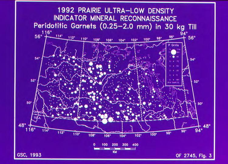
22 All Indicators (J. Armstrong, 2003)
 James Bay Lowland Stream")
23 (Kong et al., 1999) James Bay Lowland Stream sediments derived from till DE BEERS

24

25 Size Samples on the order of 10 litres Expected frequency ~ 1 indicator mineral per litre of sand May require 5 to 50 litres of sand % sand varies

26 Collection Road access, aircraft Exposures, shovel, excavator Large volume & weight Field concentration e.g. panning Field screening e.g. remove gravel


27


28


29 Boulders Striations Field observations
 >4 mm (5 mesh) Retain gravel for")
30 Processing Disaggregate Screen gravel >2 mm (10 mesh) >1 mm (20 mesh) >4 mm (5 mesh) Retain gravel for lithology


31

32

33

34

35

36


37 Density Pre-concentration Jig, table, pan, spiral, wheel Heavy liquid Size medium to very coarse sand Magnetism Reject non- paramagnetic
 Diluted MI (e.g. 3.2) Tetrabromoethane (TBE, 2.")
38 Heavy liquids Concentration Methylene iodide (MI, 3.3) Diluted MI (e.g. 3.2) Tetrabromoethane (TBE, 2.96) NaPolyW (variable) Superpanner DMS Magstream


39 Separator Hand magnet Ferromagnetics
40

41 Classification Processing of nonferromagnetics Reduce picking time Add information Sizing E.g mm; mm Magnetic susceptibility Magstream
42
43 Background Many aspects of processing are governed by regional heavy mineral background


44

45 Picking/panning Identification of possible & probable indicator minerals Recovery Morphology Spikes Re-picks


46

47 Gold grains Number Morphology Mass Composition

48


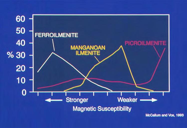
49

50

51


52

53 Sulphides Rare coated grains in aerated sediments Fresh sulphides in sediments obtained by drilling

54

55

56


57

58 Scheelite Lamping under short-wave ultraviolet

59 Base metal indicators e.g. resistates such as gahnite


60 Kimberlite indicator Cr-pyrope Mg-ilmenite Cr-spinel E-garnet Cr-diopside Olivine Diamond minerals


61 Morphology
62 Mineral chemistry Mount & polish grains Semi-quantitative analysis Quantitative major element analysis Mineral classification Trace element analysis


63

64

65

66

67

68

69

70

71

72

73
74 25 30 Pressure (kbar, N&T2000) Gph Dia mw/m Temperature ( C, N&T2000) Mineral Services
75 Interpretation & follow-up
76 Indicator mineral surveys Objective Media Spacing Size Collection Processing Pre- concentration Concentration Ferromagnetics Classification Picking Morphology Mineral chemistry Interpretation & follow-up

77

78

79

80 Minnesota indicator mineral survey

81 Minnesota indicator mineral survey
82

83

84 Minnesota indicator mineral survey
85 Minnesota indicator mineral survey

86


87

88
89

90
91


92
93


94
95

96
97

98
99

100
101
102
103

104
105
106
107
108
109
110
111
112
113
114
115
116
117
118
119
120
121
122
123
124
125
126
127
")
128 All Indicators (J. Armstrong, 2003)
129

130
131
132
133
134
135

136
137
138
139
140
141 Indicator Mineral Methods in Mineral Exploration Harvey Thorleifson Minnesota Geological Survey
Michael Michaud & Stuart Averill. Overburden Drilling Management Limited Ottawa, Ontario
 Introduced particles in indicator mineral processing: a) considerations in preparing test samples for QA/QC; and b) examples of anthropogenic contamination Michael Michaud & Stuart Averill Overburden Drilling
Till Geochemistry and Indicator Mineral Methods for Exploration in Glaciated Terrain
 Till Geochemistry and Indicator Mineral Methods for Exploration in Glaciated Terrain M. Beth McClenaghan Geological Survey of Canada Exploration 07 Workshop 2 Exploration Geochemistry: Basic Principles
SAMPLE WEIGHT The weights of material collected for indicator mineral studies will depend on the type of surficial sediment collected, the
 Processing methods for recovery of indicator minerals from sediment and bedrock M. Beth McClenaghan Geological Survey of Canada, 601 Booth Street, Ottawa, Ontario, K1A 0E8 (e-mail: bmcclena@nrcan.gc.ca)
Saskatchewan s Mineral Resources Lesson: Exploring for Minerals in Saskatchewan: Stream Sediment and Soil Sampling
 Saskatchewan s Mineral Resources Lesson: Exploring for Minerals in Saskatchewan: Stream Sediment and Soil Sampling Overview In this activity, students use information from geochemical surveys (stream sediment
Indicator Mineral Methods in Mineral Exploration
 Indicator Mineral Methods in Mineral Exploration Survey Design Chris Benn BHP Billiton Page: 1 Design of Indicator Mineral Surveys Survey design is the most important part of an indicator mineral survey.
Earth Sciences Report Alberta Kimberlite-Indicator Mineral Geochemical Compilation
 Earth Sciences Report 2001-20 Alberta Kimberlite-Indicator Mineral Geochemical Compilation Alberta Kimberlite-Indicator Mineral Geochemical Compilation D.R. Eccles 1, M. Dufresne 2, D. Copeland 2, W. Csanyi
MRD045 Can be downloaded at the following location: Please note
 MRD045 Can be downloaded at the following location: http://www.geologyontario.mndm.gov.on.ca/mndmaccess/mndm_dir.asp?type=pub&id=mrd045 Please note that all right, title and interest in this Electronic
Common Exploration Methods.
 Common Exploration Methods. The following list contains the most common methods which a company with a mineral prospecting licence in Northern Ireland might use to carry out a mineral prospecting programme.
TILL GEOCHEMICAL AND INDICATOR MINERAL RECONNAISSANCE OF MINNESOTA
 MINNESOTA GEOLOGICAL SURVEY Harvey Thorleifson, Director TILL GEOCHEMICAL AND INDICATOR MINERAL RECONNAISSANCE OF MINNESOTA L. Harvey Thorleifson, Kenneth L. Harris, Howard C. Hobbs, Carrie E. Jennings,
Don Elsenheimer, Ph.D Glenn Melchert Minnesota Dept. Natural Resources
 Regional Survey of Gold in Till, Bigfork Greenstone Belt, St. Louis & Itasca Counties, Minnesota: Follow-up Trenching in Areas with Anomalously High Gold Grain Counts Don Elsenheimer, Ph.D Glenn Melchert
Ontario Geological Survey Open File Report Regional Modern Alluvium Sampling Survey of the Cobalt -Elk Lake Area, Northeastern Ontario
 Ontario Geological Survey Open File Report 6119 Regional Modern Alluvium Sampling Survey of the Cobalt -Elk Lake Area, Northeastern Ontario 24 ONTARIO GEOLOGICAL SURVEY Open File Report 6119 Regional
Exploration 2007, Toronto Workshop 3: Indicator Mineral Methods in Mineral Exploration
 Exploration 2007, Toronto Workshop 3: Indicator Mineral Methods in Mineral Exploration Viable indicators in surficial sediments for two major base metal deposit types: Ni-Cu-PGE and porphyry Cu Presented
Metallic Mineral Exploration in Minnesota: Typical Exploration Activities. Division of Lands and Minerals Minnesota Department of Natural Resources
 Metallic Mineral Exploration in Minnesota: Typical Exploration Activities Division of Lands and Minerals Minnesota Department of Natural Resources Metallic minerals can only be mined economically where
GEOLOGY OF THE DO27 PIPE: A PYROCLASTIC KIMBERLITE IN THE LAC DE GRAS PROVINCE, NWT, CANADA
 GEOLOGY OF THE DO27 PIPE: A PYROCLASTIC KIMBERLITE IN THE LAC DE GRAS PROVINCE, NWT, CANADA Margaret Harder 1, Casey Hetman 2, Barbara Scott Smith 3, and Jennifer Pell 1 1 Peregrine Diamonds Ltd. 2 Mineral
Sedimentation & Stratigraphy. Lab 3: Heavy Mineral Analysis Using the Franz Magnetic Separator
 Sedimentation & Stratigraphy Name I. Introduction Lab 3: Heavy Mineral Analysis Using the Franz Magnetic Separator In Lab 2, we used sand size-distributions to determine if the sediments were derived from
Introduction to Prospecting. Session Four Ore Deposits
 Introduction to Prospecting Session Four Ore Deposits Ore Deposits What is ore? Common elements such as gold, copper, zinc and lead occur naturally in all rocks, however in very low quantities. Ore is
REPORTING OF DIAMOND EXPLORATION RESULTS, IDENTIFIED MINERAL RESOURCES AND ORE RESERVES
 a guideline for... REPORTING OF DIAMOND EXPLORATION RESULTS, IDENTIFIED MINERAL RESOURCES AND ORE RESERVES published by: NAPEGG The Association of Professional Engineers, Geologists and Geophysicists of
Unit E: Planet Earth. Topic 2: The Rock Cycle and Characteristics of Rocks
 Unit E: Planet Earth Topic 2: The Rock Cycle and Characteristics of Rocks 1 2.1 Three Classes of Rocks: Igneous, Sedimentary, and Metamorphic A. How Rocks Are Formed B. Types of Rock 1. All rocks can be
Ore deposits related to mafic igneous rocks Diamonds - GLY 361 Lecture 3
 Ore deposits related to mafic igneous rocks Diamonds - GLY 361 Lecture 3 A short history of diamonds Derived from the ancient Greek αδάμας (adámas): unbreakable Thought to have been first recognized and
COMBINATION OF MMI AND ENZYME LEACH METHODS IN EXPLORATION FOR GOLD IN AN AREA OF THE CANADIAN SHIELD COVERED WITH GLACIAL SEDIMENTS: A CASE STUDY
 COMBINATION OF MMI AND ENZYME LEACH METHODS IN EXPLORATION FOR GOLD IN AN AREA OF THE CANADIAN SHIELD COVERED WITH GLACIAL SEDIMENTS: A CASE STUDY Nadia Yavorskaya 450 Bonner Ave., Winnipeg, MB, Canada
Forward Looking Statements
 Forward Looking Statements Except for the statements of historical fact contained herein, certain information presented constitutes "forward-looking statements" within the meaning of the United States
In the past century, prospectors discovered
 FEATURE Instrumentation GDD Inc. s Beep Map Is prospecting dead? By Edwin Gaucher, Eng., Ph.D. and Pierre Gaucher, Eng., MBA In the past century, prospectors discovered many mines while examining shorelines
ASX Release 2 December 2010 LONRHO MINING LIMITED (ASX: LOM) QUARTERLY REPORT FOR PERIOD ENDED 30 NOVEMBER 2010 HIGHLIGHTS
 QUARTERLY REPORT FOR PERIOD ENDED 30 NOVEMBER 2010 HIGHLIGHTS") ASX Release 2 December 2010 LONRHO MINING LIMITED (ASX: LOM) HIGHLIGHTS Lulo Diamond Concession, Angola (LOM 39%) Impressive results encountered from the first alluvial gravels treated through the Dense
ASX Release 2 December 2010 LONRHO MINING LIMITED (ASX: LOM) HIGHLIGHTS Lulo Diamond Concession, Angola (LOM 39%) Impressive results encountered from the first alluvial gravels treated through the Dense
Tin Mineralisation. in the Mesoproterozoic Prospect Hill Region, Northern Flinders Ranges: Recent Drilling Results and Suggestions for Regional
 Tin Mineralisation in the Mesoproterozoic Prospect Hill Region, Northern Flinders Ranges: Recent Drilling Results and Suggestions for Regional Tin Exploration in South Australia UNCOVER CURNAMONA 2017
Early Exploration Plan Activity Information
 Early Exploration Plan Activity Information Activities That Require an Early Exploration Plan: Line cutting that is a width of 1.5 metres or less; Geophysical surveys on the ground requiring the use of
Petrographic Investigation of Two Float Samples from the Goldstake Property, Northern Ontario. Prepared for: Mr. Robert Dillman
 Petrographic Investigation of Two Float Samples from the Goldstake Property, Northern Ontario Prepared for: Mr. Robert Dillman by Jim Renaud Renaud Geological Consulting Ltd. 21272 Denfield Road London,
Hugo Dubé-Loubert, Virginie Daubois, Guillaume Allard (MERN) and Martin Roy (UQAM) PRO
 and Martin Roy (UQAM) PRO") BY QUATERNARY SURVEYS,, (MERN) and Martin Roy (UQAM) PRO 2015-04 Exploration targets identified by surveys in the southeastern part of the Province,, (MERN) and Martin Roy (UQAM) PRO 2015-04 Introduction
BY QUATERNARY SURVEYS,, (MERN) and Martin Roy (UQAM) PRO 2015-04 Exploration targets identified by surveys in the southeastern part of the Province,, (MERN) and Martin Roy (UQAM) PRO 2015-04 Introduction
B-1 BORE LOCATION PLAN. EXHIBIT Drawn By: 115G BROOKS VETERINARY CLINIC CITY BASE LANDING AND GOLIAD ROAD SAN ANTONIO, TEXAS.
 N B-1 SYMBOLS: Exploratory Boring Location Project Mngr: BORE LOCATION PLAN Project No. GK EXHIBIT Drawn By: 115G1063.02 GK Scale: Checked By: 1045 Central Parkway North, Suite 103 San Antonio, Texas 78232
BOREHOLE GEOPHYSICAL LOGGING IN UNCONSOLIDATED SEDIMENTS -AN AID TO 3-D 3 D MAPPING. J.A. Hunter Geological Survey of Canada
 BOREHOLE GEOPHYSICAL LOGGING IN UNCONSOLIDATED SEDIMENTS -AN AID TO 3-D 3 D MAPPING J.A. Hunter Geological Survey of Canada QUALITATIVE PARAMETERS - grain size - sediment type - porosity - density - pore-water
YUKON TERRITORIAL GOVERNMENT EXPLORATION INCENTIVES PROGRAM PROJECT
 YUKON TERRITORIAL GOVERNMENT EXPLORATION INCENTIVES PROGRAM PROJECT 05-012 PLACER EXPLORATION ON THOMPSON CREEK / PROCTOR LAKE PROJECT SAMPLING MAY 01,2005 - NOVEMBER 31,2005 PLACER PROSPECTING LEASES:
GS Manitoba Geological Survey
 GS2018-14 In Brief: Four till units were identified in drillcore KK1 based on composition data Shale and siltstone clast concentrations in till suggest that this bedrock unit is more extensive in this
For personal use only
 GOLD MOUNTAIN LIMITED ABN 79 115 845 942 SEPTEMBER 2015 QUARTERLY REPORT KEY POINTS. Completion of Ground Magnetics Geophysical Survey on Crown Ridge EL1968 aiming to define hard rock drilling targets.
MAD345 - Mining II INTRODUCTION. 10 October Hacettepe University. Introduction Prospecting Mining Dilution Resource and Reserve Estimation
 MAD345 - Mining II INTRODUCTION 10 October 2018 Course content MAD345 THEORY Date October, 10 October, 17 October, 24 October, 31 November, 7 November, 14 November, 21 Topic Introduction Prospecting, exploration
Ligand-Based Partial Extraction Of Soil Samples: An Innovative Approach To The Assessment Of Hydrocarbon Prospectivity
 Ligand-Based Partial Extraction Of Soil Samples: An Innovative Approach To The Assessment Of Hydrocarbon Prospectivity Mark Fedikow Ph.D. P.Eng. P.Geo. C.P.G. Mount Morgan Resources Ltd. Winnipeg, Manitoba
GAWLER IRON PROJECT PROGRESS UPDATE
 ASX Release and Media Announcement 18 February 2010 GAWLER IRON PROJECT PROGRESS UPDATE Iron Road Limited (Iron Road, ASX: IRD, IRDO) is pleased to announce that significant progress has been made at the
Report of Gridding and Magnetic Surveys. On the. Munro Property. Munro and Beatty Townships, Ontario. Larder Lake Mining Division
 Report of Gridding and Magnetic Surveys On the Munro Property Munro and Beatty Townships, Ontario Larder Lake Mining Division Claims: 39 4244 For Big Red Diamond Corporation October 3, 2 Timmins, Ontario
SEDIMENT DESCRIPTION
 SEDIMENT DESCRIPTION Coring Coring at Blundell s Flat SEDIMENT DESCRIPTION Core Splitting Cores should be split into two halves using materials and procedures that will minimize disturbance and contamination,
State of the science tools for. glacial sediments. Brandy M. Toner Department of Soil, Water, and Climate
 State of the science tools for measuring arsenic speciation in glacial sediments Brandy M. Toner Department of Soil, Water, and Climate University of Minnesota Collaborators U.S. Geological Survey Mlid
Condor Blanco Mines Limited (Code: CDB) Company Presentation Devil s Creek Tenement E70/4529
 Company Presentation Devil s Creek Tenement E70/4529") Condor Blanco Mines Limited (Code: CDB) Company Presentation Devil s Creek Tenement E70/4529 Disclaimer This document is not a disclosure document nor does it constitute the provision of financial product
Condor Blanco Mines Limited (Code: CDB) Company Presentation Devil s Creek Tenement E70/4529 Disclaimer This document is not a disclosure document nor does it constitute the provision of financial product
CAMBRIDGE NICKEL PROSPECT EXPLORATION UPDATE. XRF analysis of reconnaissance drill holes at Cambridge has been completed
 17 December 2012 CAMBRIDGE NICKEL PROSPECT EXPLORATION UPDATE HIGHLIGHTS XRF analysis of reconnaissance drill holes at Cambridge has been completed Initial geological logging and XRF analysis identifies
Till Geochemical and Indicator Mineral Methods in Mineral Exploration
 Exploration Geochemistry Paper 31 till, geochemical surveys, drift prospecting, mineral exploration, glaciated terrain, Finland, Fennoscandia, Canada, diamonds, indicator minerals, kimberlites, gold Explor97
Exploring Diamond Opportunities in Canada. North Arrow Minerals Corporate Update with a focus on the Qilalugaq Diamond Project
 TSXV: TSXV:NAR Exploring Diamond Opportunities in Canada North Arrow Minerals Corporate Update with a focus on the Qilalugaq Diamond Project CAUTIONARY STATEMENT Forward Looking Information This presentation
A Discovery Company. Exploring for Canadian Diamonds
 A Discovery Company Exploring for Canadian Diamonds January, 2015 Forward Looking Statement Certain statements contained in this presentation may contain forward-looking information within the meaning
New Kimberlite Pipe Discovery at Dunnedin s Kahuna Project
 DUNNEDIN VENTURES INC. TSX-V: DVI Suite 1020, 800 West Pender Street Vancouver, British Columbia, V6C 2V6 Tel: 604.646.8351 / Fax: 604.646.4526 New Kimberlite Pipe Discovery at Dunnedin s Kahuna Project
Geology 229 Engineering Geology. Lecture 6. Basic Rock Classification and Engineering Considerations (West, Chs. 2, 3, 4, 5)
") Geology 229 Engineering Geology Lecture 6 Basic Rock Classification and Engineering Considerations (West, Chs. 2, 3, 4, 5) Outline of this Lecture 1. Rock types and rock cycle 2. Geological and engineering
Geology 229 Engineering Geology Lecture 6 Basic Rock Classification and Engineering Considerations (West, Chs. 2, 3, 4, 5) Outline of this Lecture 1. Rock types and rock cycle 2. Geological and engineering
MINERAL SEPARATION AND PROVENANCE LAB EXERCISE
 MINERAL SEPARATION AND PROVENANCE LAB EXERCISE Mary Roden-Tice Center for Earth and Environmental Science State University of New York at Plattsburgh Plattsburgh, NY 12901 Mary.Roden-Tice@plattsburgh.edu
11/22/2010. Groundwater in Unconsolidated Deposits. Alluvial (fluvial) deposits. - consist of gravel, sand, silt and clay
 deposits. - consist of gravel, sand, silt and clay") Groundwater in Unconsolidated Deposits Alluvial (fluvial) deposits - consist of gravel, sand, silt and clay - laid down by physical processes in rivers and flood plains - major sources for water supplies
Groundwater in Unconsolidated Deposits Alluvial (fluvial) deposits - consist of gravel, sand, silt and clay - laid down by physical processes in rivers and flood plains - major sources for water supplies
Tikrit University College of Engineering Civil engineering Department
 Tikrit University SOIL CLASSIFICATION College of Engineering Civil engineering Department Soil Mechanics 3 rd Class Lecture notes Up Copyrights 2016 Classification of soil is the separation of soil into
Shorelines and Diesel
 Shorelines and Diesel Rock Platforms (bedrock): A common shoreline type with a rocky environment that is both exposed and submerged from tide cycles. Platforms are generally horizontal and collect sediments
DUNNEDIN VENTURES INC.
 . PST Kimberlite First Diamond Results November 2015 1 FORWARD LOOKING STATEMENT Except for historical information contained herein, this presentation may contain forward-looking statements including but
Bishopville Prong Study
 Bathymetric and Sediment Assessment in the Bishopville Prong of St. Martin River Darlene V. Wells, Richard A. Ortt, Jr., and Stephen Van Ryswick Funded by MCBP 2011-2012 Implementation Grant Objectives
5. Which surface soil type has the slowest permeability rate and is most likely to produce flooding? A) pebbles B) sand C) silt D) clay A) B) C) D)
 pebbles B) sand C) silt D) clay A) B) C) D)") 1. During a heavy rainstorm, soil samples A and B both became saturated with water. However, 10 minutes after the storm ended, the soils appeared as shown below. Which statement best explains the observed
1. During a heavy rainstorm, soil samples A and B both became saturated with water. However, 10 minutes after the storm ended, the soils appeared as shown below. Which statement best explains the observed
Construction Exits Vibration grids
 Construction Exits Vibration grids SEDIMENT CONTROL TECHNIQUE Type 1 System Sheet Flow Sandy Soils Type 2 System Concentrated Flow Clayey Soils [1] Type 3 System Supplementary Trap Dispersive Soils [1]
Sandy Point Beach, Cousins Island, Yarmouth, Maine
 Maine Geologic Facts and Localities April, 2008 Sandy Point Beach, Cousins Island, Yarmouth, Maine 43 o 46 25.46 N, 70 o 8 44.84 W Text by Tom Weddle, Department of Agriculture, Conservation & Forestry
TI-PA-HAA-KAA-NING (TPK) Gold Property
 Gold Property") NORTHERN SUPERIOR RESOURCES TI-PA-HAA-KAA-NING (TPK) Gold Property H1, 2018 TSXV:SUP/ OTCQB:NSUPF Safe Harbour Statement Cautionary Note Regarding Forward-Looking Statements: This Press Release contains
NORTHERN SUPERIOR RESOURCES TI-PA-HAA-KAA-NING (TPK) Gold Property H1, 2018 TSXV:SUP/ OTCQB:NSUPF Safe Harbour Statement Cautionary Note Regarding Forward-Looking Statements: This Press Release contains
FACTS FOR DIAMOND OCCURRENCE IN KIMBERLITES
 KIMBERLITES Kimberlite is an ultrabasic olivine-rich igneous rock called peridotite. Peridotites occur at great depths in the earth in a layer called the mantle (100-135 miles below the surface). At this
INTRODUCTION Prospectivity mapping Study area and methods
 Quaternary geological and till geochemical studies in verifying GIS-based prospectivity mapping in the Central Lapland Greenstone Belt, northern Finland Sarala Pertti, Nykänen Vesa, Sarapää Olli, Peltoniemi
Progress Report (Mali), November 2011 T. Jerzykiewicz (Geoclastica Consulting Ltd), W. Sliwinski (Geological Consultant)
, November 2011 T. Jerzykiewicz (Geoclastica Consulting Ltd), W. Sliwinski (Geological Consultant)") Progress Report (Mali), November 2011 T. Jerzykiewicz (Geoclastica Consulting Ltd), W. Sliwinski (Geological Consultant) November Field Work in Mali s Block #25 Introduction The main objective of the field
Progress Report (Mali), November 2011 T. Jerzykiewicz (Geoclastica Consulting Ltd), W. Sliwinski (Geological Consultant) November Field Work in Mali s Block #25 Introduction The main objective of the field
ROCK FORAGE CONSULTING SERVICES SITE VISIT REPORT
 i ROCK FORAGE CONSULTING SERVICES SITE VISIT REPORT SUMMARY REPORT OF SITE VISIT TO GOLDEN SAINT FIELD OPERATIONS IN SIERRA LEONE, 9 th FEBRUARY 4 th MARCH 2017 Report No. RFM_2017_011 20 May 2017 AUTHORS:
Hydro One (Sept 2014) Hydro One (Sept 2014) Hydro One (Sept 2014)
 Hydro One (Sept 2014) Hydro One (Sept 2014)") TABLE 1 WELL CONSTRUCTION DETAILS MOE WWR No Well ID Location Installation Date Status Easting Coordinates Northing Source Elevation Screened Interval Screened Material Borehole Well Stick-up Ground Top
TABLE 1 WELL CONSTRUCTION DETAILS MOE WWR No Well ID Location Installation Date Status Easting Coordinates Northing Source Elevation Screened Interval Screened Material Borehole Well Stick-up Ground Top
STUDY PERFORMANCE REPORT
 STUDY PERFORMANCE REPORT State: Michigan Project No.: F-80-R-8 Study No.: 230702 Title: Effects of sediment traps on Michigan river channels Period Covered: October 1, 2006 to September 30, 2007 Study
HOW. HOW vehicle mounted units portable units also available. HOW, WHEN & WHY to Geophysically Log in S.I.?
 HOW, WHEN & WHY to Geophysically Log in S.I.? by Kim Beesley HOW HOW vehicle mounted units portable units also available Access to borehole Depth of borehole sump / rat -hole? 1 HOW? - subject to borehole
DÉCOUVERTE Positioned for Discovery in James Bay, Quebec. Investor Presentation, January 2018 by Danae Voormeij, MSc, PGeo
 DÉCOUVERTE Positioned for Discovery in James Bay, Quebec Investor Presentation, January 2018 by Danae Voormeij, MSc, PGeo Location Maps and Infrastructure Location: Durango Resources 100% owned Découverte
GEOLOGICAL MAPPING OF SKARNS ON THE SHEEP AND EWE CLAIMS, TURNAGAIN RIVER, B.C. DURING THE 1979 SUMMER SEASON
 GEOLOGICAL MAPPING OF SKARNS ON THE SHEEP AND EWE CLAIMS, TURNAGAIN RIVER, B.C. DURING THE 1979 SUMMER SEASON CLAIMS: Sheep 1 to 4 Ewe 1, 3, 4 to 8 Lamb 12 Fraction Liard Mining Division, B.C. NTS 104
Earth Science 232 Petrography
 Earth Science 232 Petrography Course notes by Shaun Frape and Alec Blyth Winter 2002 1 Petrology - Introduction Some Definitions Petra Greek for rock Logos Greek for disclosure or explanation Petrology
Mineral Discoveries Using Big Data Analytics: Azimut s Exploration Edge
 Mineral Discoveries Using Big Data Analytics: Azimut s Exploration Edge Jean-Marc Lulin, PhD, P.Geo. Sprott Natural Resource Symposium July 2017 Azimut: Big Data Analytics in Exploration 1) Why use Big
Simplified exploration work report
 Simplified exploration work report Work Report of exploration and examination of outcrops of rock and boulders Report on stripping and excavating work of $ 5 000 or less.(section 81 of regulation) Report
ENCE 3610 Soil Mechanics. Site Exploration and Characterisation Field Exploration Methods
 ENCE 3610 Soil Mechanics Site Exploration and Characterisation Field Exploration Methods Geotechnical Involvement in Project Phases Planning Design Alternatives Preparation of Detailed Plans Final Design
ZONGE GEOSCIENCES, INC.
 ZONGE GEOSCIENCES, INC. GEOPHYSICAL INVESTIGATION REPORT 2D Seismic Reflection Survey Crump Geyser Geothermal Prospect Warner Valley, Oregon Prepared for: John Casteel District Geologist Nevada Geothermal
LUCAPA CONFIRMS DIAMOND POTENTIAL AT BROOKING PROJECT
 ASX Announcement 23 November 2016 LUCAPA CONFIRMS DIAMOND POTENTIAL AT BROOKING PROJECT HIGHLIGHTS Exploration by Lucapa has validated positive historical results at the Brooking Diamond Project in WA,
patersongroup Mineral Aggregate Assessment 3119 Carp Road Ottawa, Ontario Prepared For Mr. Greg LeBlanc March 7, 2014 Report: PH2223-REP.
 Geotechnical Engineering Environmental Engineering group Hydrogeology Geological Engineering Archaeological Studies Materials Testing 3119 Carp Road Prepared For Mr. Greg LeBlanc March 7, 2014 Paterson
ASX / MEDIA RELEASE 6 MAY MILE SILVER-LEAD-ZINC DISCOVERY; HIGH GRADE SILVER-GOLD IN ROCK CHIPS AT RUBY SILVER
 ASX / MEDIA RELEASE 6 MAY 2011 4-MILE SILVER-LEAD-ZINC DISCOVERY; HIGH GRADE SILVER-GOLD IN ROCK CHIPS AT RUBY SILVER Highlights: Silver-lead-zinc discovery at 4-Mile; mineralisation intersected in all
SIXTH SCHEDULE REPUBLIC OF SOUTH SUDAN MINISTRY OF PETROLEUM, MINING THE MINING (MINERAL TITLE) REGULATIONS 2015
 REGULATIONS 2015") SIXTH SCHEDULE REPUBLIC OF SOUTH SUDAN MINISTRY OF PETROLEUM, MINING THE MINING ACT, 2012 THE MINING (MINERAL TITLE) REGULATIONS 2015 Guidelines should be prepared by the Directorate of Mineral Development
SIXTH SCHEDULE REPUBLIC OF SOUTH SUDAN MINISTRY OF PETROLEUM, MINING THE MINING ACT, 2012 THE MINING (MINERAL TITLE) REGULATIONS 2015 Guidelines should be prepared by the Directorate of Mineral Development
Summary of Rover Metals Geologic Mapping Program at the Up Town Gold Project, Northwest Territories
 October 13, 2017 Summary of Rover Metals Geologic Mapping Program at the Up Town Gold Project, Northwest Territories Vancouver, British Columbia, Canada - Rover Metals Corp., Rover, is pleased to provide
Ground-Water Exploration in the Worthington Area of Nobles County: Summary of Seismic Data and Recent Test Drilling Results
 Ground-Water Exploration in the Worthington Area of Nobles County: Summary of Seismic Data and Recent Test Drilling Results Jim Berg and Todd Petersen Geophysicists, DNR Waters January 2000 Table of Contents
APPENDIX G GLOSSARY. Mn/DOT/WR-0200
 APPENDIX G GLOSSARY Mn/DOT/WR-0200 Alluvial - comprised of clay, silt, sand, gravel, and/or other detritus deposited by water. Usually refers to accretionary overbank, floodplain or levee deposits. Biomantling
Igneous Rocks. Sedimentary Rocks. Metamorphic Rocks
 Name: Date: Igneous Rocks Igneous rocks form from the solidification of magma either below (intrusive igneous rocks) or above (extrusive igneous rocks) the Earth s surface. For example, the igneous rock
Gold c 8 Rl!TI I8 8 I0 n0 '8 Off VANCOUVER, B.C. btandard I Property
 ,- PROSPECTING REPORT For the 1 Gold c 8 Rl!TI I8 8 I0 n0 '8 Off ig@ VANCOUVER, B.C. btandard I Property I SALMON GOVERNMENT AGENT ARM I Tenure Number 554772 Revelstoke Mining Division, B.C. BCGS GRID
A Convenient a Joint Venture Patterson Lake South
 Patterson Lake South (PLS) Property A Convenient a Joint Venture Patterson Lake South December 2012 TSX.V: AMW and FIS Garrett Ainsworth, PGeo, Alpha Minerals Inc. Saskatchewan Open House, Dec. 2012 Disclaimer
GEOLOGY OF THE VICTOR KIMBERLITE, ATTAWAPISKAT, NORTHERN ONTARIO, CANADA: CROSS-CUTTING AND NESTED CRATERS
 GEOLOGY OF THE VICTOR KIMBERLITE, ATTAWAPISKAT, NORTHERN ONTARIO, CANADA: CROSS-CUTTING AND NESTED CRATERS Kimberley Webb 1, Barbara Scott Smith 2, Joanne Paul 3 and Casey Hetman 1 1 De Beers Canada Kimberlite
Canada s Most Active Diamond Explorer
 TSXV: TSXV:NAR Canada s Most Active Diamond Explorer February 2018 CAUTIONARY STATEMENT Forward Looking Information This presentation contains projections and forward looking information that involve various
CONCENTRATION PATTERN OF HEAVY MINERALS ALONG THE KONARK-RAMACHANDI COASTAL STRETCH AND ITS RECOVERY PROCESS FOR INDUSTRIAL APPLICATIONS
 Journal of Mining and Metallurgy, 48 A (1) (2012) 51-61 J o u r n a l o f M i n i n g a n d M e t a l l u r g y CONCENTRATION PATTERN OF HEAVY MINERALS ALONG THE KONARK-RAMACHANDI COASTAL STRETCH AND ITS
Manual on Subsurface Investigations National Highway Institute Publication No. FHWA NHI Federal Highway Administration Washington, DC
 Manual on Subsurface Investigations National Highway Institute Publication No. FHWA NHI-01-031 Federal Highway Administration Washington, DC Geotechnical Site Characterization July 2001 by Paul W. Mayne,
Comparison of Soviet Classified Resources to JORC Code (2004) Source: Wardel Armstrong International
 Source: Wardel Armstrong International") Comparison of Soviet Classified Resources to JORC Code (2004) Source: Wardel Armstrong International Table of Contents Soviet Resources and Reserves... 1 Soviet System of Resource/Reserve Classification
Comparison of Soviet Classified Resources to JORC Code (2004) Source: Wardel Armstrong International Table of Contents Soviet Resources and Reserves... 1 Soviet System of Resource/Reserve Classification
Geophysical Exploration in Water Resources Assessment. John Mundell, P.E., L.P.G., P.G. Ryan Brumbaugh, L.P.G. Mundell & Associates, Inc.
 Geophysical Exploration in Water Resources Assessment John Mundell, P.E., L.P.G., P.G. Ryan Brumbaugh, L.P.G. Mundell & Associates, Inc. Presentation Objective Introduce the use of geophysical survey methods
The Geology of Sebago Lake State Park
 Maine Geologic Facts and Localities September, 2002 43 55 17.46 N, 70 34 13.07 W Text by Robert Johnston, Department of Agriculture, Conservation & Forestry 1 Map by Robert Johnston Introduction Sebago
Report of Induced Polarization Surveys and. Total Field Magnetic Surveys. Turtle Pond, Emmons Lake, Prig, North Glatz, Glatz, and Double E Grids
 Report of nduced Polarization Surveys and Total Field Magnetic Surveys On the Turtlepond Project Turtle Pond, Emmons Lake, Prig, North Glatz, Glatz, and Double E Grids Turtlepond Lake Area, Ontario Claim
Carbon Sequestration in Basalts: Laboratory Studies and Field Demonstration
 Carbon Sequestration in Basalts: Laboratory Studies and Field Demonstration H. T. Schaef B.P. McGrail Workshop on Geologic Capture and Sequestration of Carbon Stanford University November 28, 2017 Needles
Follow this and additional works at: Part of the Geology Commons
 Western Michigan University ScholarWorks at WMU Michigan Geological Repository for Research and Education Geosciences 2016 Geology of Michigan William B. Harrison III Michigan Geological Repository for
Early Exploration Permit Activity Information
 Early Exploration Permit Activity Information Activities That Require an Early Exploration Permit: Line cutting that is a width greater than 1.5 metres Mechanized stripping of a total surface area of greater
SAGE GOLD INC. MINERAL BENEFICIATION ON CANE GOLD ORE. RPC Reference No.: PET-J1557. Prepared for:
 SAGE GOLD INC. MINERAL BENEFICIATION ON CANE GOLD ORE Prepared for: Mr. Bill Love Sage Gold Inc. 365 Bay Street, Suite 500 Toronto, Ontario Canada, M5H 2V1 Prepared by: Ross Gilders Section Head, Process
Negro Creek Fort Steele Minina Division. CRAIG KENNEDY Prospector
 AUG and SKAY Claims Negro Creek Fort Steele Minina Division NTS 82 F8/E Latitude 49O28 N Lonqi tude 116 Ol W BY CRAIG KENNEDY Prospector September 5, 1996 TABLE OF CONTENTS Page 1.00 INTRODUCTION 1.10
CARIBOO - GRIZZLY ZINC PROJECT
 CARIBOO - GRIZZLY ZINC PROJECT The Grizzly Lake or Cariboo Zinc property straddles the gravel Weldwood 8400 logging road in the Grizzly Lake area about 55 kilometres northeast of Likely. Roads constructed
GEOLOGICAL SITE INVESTIGTION IN PONDICHERRY
 International Journal of Research and Reviews in Applied Sciences And Engineering (IJRRASE) Vol 8. No.1 2016 Pp.130--135 gopalax Journals, Singapore available at : www.ijcns.com ISSN: 2231-0061 GEOLOGICAL
Ronin Placer Ground-penetrating Radar Survey Report
 Ronin Placer Ground-penetrating Radar Survey Report Tenures: 837095, 837097 Mining Division: Greenwood NTS Location: 082E/03 Geographic Center Coordinates: UTM Zone 11, E 345340, N 5438730 Claims Owner:
Michigan s Geology and Groundwater
 Michigan s Geology and Groundwater Ralph J. Haefner Deputy Director U.S. Geological Survey Michigan-Ohio Water Science Center Lansing, Michigan Outline About the USGS Geology 101 Michigan s geology Bedrock
Perspectives on the Design of Step-Pool Stream Channel Segments. Mike Burke, Shawn Chartrand and Andy Collison
 Perspectives on the Design of Step-Pool Stream Channel Segments Mike Burke, Shawn Chartrand and Andy Collison Motivation: Share perspectives and observations on step-pool design that t have informed our
Correlations between spectral mineralogy and borehole rock properties in the Eromanga Basin. Ian Roach
 Correlations between spectral mineralogy and borehole rock properties in the Eromanga Basin Ian Roach Introduction The Southern Thomson Project Stratigraphic drilling & logging program Rock properties
For personal use only
 ASX ANNOUNCEMENT 2nd February 2012 PROMISING DRILLING RESULTS FROM KUINI PROSPECT IN ACEH ASX: PSP SHARE INFORMATION Issued Shares: 346.54m Unlisted Options: 20.95m BOARD OF DIRECTORS Chairman & MD: M.
Mineral Deposit Report Page 1 OF Geological Survey of Finland
 Mineral Deposit Report Page 1 OF 11 07.08.2017 Haarakumpu Occurence type: deposit Commodity Rank Total Total production Total resource Importance measure cobalt 1 7748 t 7748 t Medium sized deposit copper