DIRECTORY OF COAL MINES IN ILLINOIS 7.5-MINUTE QUADRANGLE SERIES PINCKNEYVILLE QUADRANGLE PERRY COUNTY
|
|
|
- Susan Jackson
- 5 years ago
- Views:
Transcription

1

2

3 DIRECTORY OF COAL MINES IN ILLINOIS 7.5-MINUTE QUADRANGLE SERIES PINCKNEYVILLE QUADRANGLE PERRY COUNTY Alan R. Myers & C. Chenoweth 2009 Institute of Natural Resource Sustainability William W. Shilts, Executive Director ILLINOIS STATE GEOLOGICAL SURVEY E. Donald McKay III, Interim Director Natural Resources Building 615 East Peabody Drive Champaign, Illinois Phone Fax
4 This material is based upon work supported by the Illinois Mine Subsidence Insurance Fund. Any opinions, findings, and conclusions or recommendations expressed in this publication are those of the authors and do not necessarily reflect the views of the Illinois Mine Subsidence Insurance Fund. Cover photo Track-mounted duckbill loading machine at a Peabody Coal Company mine, ca DISCLAIMER: The accuracy and completeness of mine maps and directories vary with the availability of reliable information. Maps and other information used to compile this mine map and directory were obtained from a variety of sources and the accuracy of some of the original information cannot be verified. Consequently, the Illinois State Geological Survey (ISGS) cannot guarantee the mine maps are free of errors and disclaims any responsibility for damages that may result from actions or decisions based on them. The ISGS updates the maps and directories periodically, and welcomes any new information or corrections. Please contact the Coal Section of the ISGS at the address shown on the title page of this directory, or telephone (217) The Board of Trustees of the University of Illinois. All rights reserved. For permission information, contact the Illinois State Geological Survey.
5 CONTENTS INTRODUCTION... 1 MINING IN THE PINCKNEYVILLE QUADRANGLE... 1 PART I EXPLANATION OF MAP AND MINE SUMMARY SHEET... 2 INTERPRETING THE MAP... 2 Mine Type and Method... 2 Source Maps... 3 Points and Labels... 3 INTERPRETING A MINE SUMMARY SHEET... 6 REFERENCES... 8 PART II DIRECTORY OF MINES IN THE PINCKNEYVILLE QUADRANGLE... 9 MINE SUMMARY SHEETS... 9 Mine Index 90 Pinckneyville Company, Pinckneyville No. 5 Mine... 9 Mine Index 177 Illinois Sixth Vein Coal Company, Schneider Mine Mine Index 297 Bessemer Washed Coal Company, White Walnut Mine Mine Index 623 Truax-Traer Coal Company, Pyramid Mine Mine Index 634 Service Coal Company, Service No. 6 Mine Mine Index 774 H. E. Presswood Coal Company, Presswood Mine Mine Index 864 Consolidation Coal Company, Burning Star No. 2 Mine Mine Index 873 Arch of Illinois, Inc., Captain Mine Mine Index 932 Consolidation Coal Company, Burning Star No. 4 Mine Mine Index 1012 Arch of Illinois, Inc., Horse Creek Mine Mine Index 1016 Arch of Illinois, Inc., Conant Underground Mine Mine Index 3115 White Brothers Coal Company, White Mine Mine Index 3118 Gem Coal Company, Gem Mine Mine Index 3120 Donk Brothers, Beaucoup Mine Mine Index 3121 Manufacturers Fuel Company, Jupiter No. 4 Mine Mine Index 3123 Big 5 Coal Company, Big 5 Mine Mine Index 3136 Pyramid Coal Corporation, Pyramid Slope Mine Mine Index 3175 Burke Coal Company, Burke Mine Mine Index 3176 Pyramid Coal Corporation, Coal Stripping Mine Mine Index 4413 L. & M. Coal Company, Tallo Mine Mine Index 7341 John H. Schulze, Schulze Mine Mine Index 7346 Biby Coal Company, Biby Mine... 30
6 OTHER MINES SHOWN ON PINCKNEYVILLE QUADRANGLE Mine Index 3130, Gorgen Mine Mine Index Mine Index Mine Index Mine Index Mine Index Mine Index Mine Index Mine Index MINES WHOSE LOCATIONS ARE NOT KNOWN, PINCKNEYVILLE QUADRANGLE INDEX OF MINES IN THE PINCKNEYVILLE QUADRANGLE... 33
7 INTRODUCTION Coal has been mined in 76 counties of Illinois. More than 7,400 coal mines have operated since commercial mining began in Illinois about 1810; fewer than 30 are currently active. To detail the extent and location of coal mining in Illinois, the Illinois State Geological Survey (ISGS) has compiled maps and directories of known coal mines. The ISGS offers maps at a scale of 1:100,000 and accompanying directories for each county in which coal mining is known to have occurred. Maps at a scale of 1:24,000 and accompanying directories, such as this, are available for selected quadrangles. Contact the ISGS for a list of these quadrangles. These larger scale maps show the approximate positions of mines in relation to surface features such as roads and water bodies, and indicate the mining method used and the accuracy of the mine boundaries. The maps are useful for locating mine boundaries relative to specific properties and for assessing the potential for subsidence in an area. Mine boundaries compiled from final mine surveys are generally shown within 200 feet of their true position. As a result of poor cartographic quality and inaccuracies in the original mine surveys, boundaries of some older mines may be mislocated on the map by 500 feet or more. Original mine maps should be consulted in situations that require precise delineation of mine boundaries or internal workings of mined areas. This directory serves as a key to the accompanying mine map and provides basic information on the coal mines in the quadrangle. The directory is composed of two parts. Part I explains the symbols and patterns used on the accompanying map and the summary data presented for each mine. Part II numerically lists the mines in the quadrangle and summarizes the geology and production history of each mine. Total production for the mine, not the portion in the quadrangle, is given. MINING IN THE PINCKNEYVILLE QUADRANGLE in this area began about 1 mile northwest of Pinckneyville in Beaucoup Mine (mine index 3120) operated until 1884, and the town platted nearby was named Beaucoup Mines, although that name does not appear on current maps. The Herrin Coal was the seam most often mined in Perry County, with a thickness ranging from 4.5 to 7 feet, and a depth commonly less than 100 feet. Because of that, the coal was readily accessible by surface or underground methods. The Pyramid Slope Mine (mine index 3136) and Gorgen Mine (mine index 3130) operated where the bedrock was less than 35 feet thick, a condition that can lead to roof difficulties in underground mines. However, most of these conditions were seen in the large surface mines in the southern portion of the quadrangle, where the difficulties rarely threatened the miners lives. 1
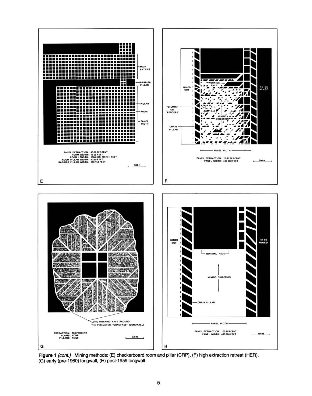
8 PART I EXPLANATION OF MAP AND MINE SUMMARY SHEET INTERPRETING THE MAP The map accompanying this directory shows the location of coal mines known to be present in the quadrangle. The map, corresponding to a U.S. Geological Survey (USGS) 7.5-minute quadrangle, covers an area bounded by lines of latitude and longitude 7.5-minutes apart. In Illinois, a quadrangle is approximately 6.5 miles east to west and 8.5 miles north to south, an area of about 56 square miles. The ISGS generally offers one map of mines per quadrangle. In some areas where extensive mining occurred in two or more overlapping seams, separate maps are compiled for mines in each seam to maintain readability of the map. Mine Type and Method The mine type is indicated on the map by pattern color: green represents surface mines; red and yellow represent underground mines. The red patterns are used for areas of underground mining that are documented by a primary or secondary source map. A yellow pattern is used for cases where no map of the mine workings is available, but a general area of mining can be inferred from property maps or production figures. The patterns indicate the main mining methods used in underground mines. The methods are (1) room and pillar and (2) high extraction. The method used gives some indication of the amount and pattern of coal extraction within each mined area, and has some influence on the timing and type of subsidence that can occur over a mine. The following discussion and illustrations of mining methods are based on Guither et al. (1984). In room-and-pillar mines, coal is removed from haulage-ways (entries) and selected areas called rooms. Pillars of unmined coal are left between the rooms to support the roof. Depending on the size of rooms and pillars, the amount of coal removed from the production areas will range from 40% to 70%. Room and Pillar - mining is divided into six categories: room-and-pillar basic (RPB, fig. 1A), an early method that did not follow a preset mining plan and therefore resulted in very irregular designs; modified room and pillar (MRP, fig. 1B); room-and-pillar panel (RPP, fig. 1C); blind room and pillar (BRP, fig. 1D); checkerboard room and pillar (CRP, fig. 1E); room and pillar (RP), a classification used when the specific type of room-and-pillar mining is unknown. Blind and checkerboard are the most common types of room-and-pillar mining used in Illinois today. The knowledge of room-and-pillar mining methods gives a trained engineer information on the nature of subsidence that may occur. A more extensive discussion of subsidence can be found in Bauer et al. (1993). High-extraction These mining methods are subdivided into high-extraction retreat (HER, Fig 1F) and longwall (LW, Fig 1G, 1H). In these methods, much of the coal is removed within well defined areas of the mine. Subsidence of the surface above these areas occurs within weeks. Once the subsidence activity ceases, the potential for further movement over these areas is low; however, subsidence may continue for several years after mining. High-extraction retreat mining is a form of room-and-pillar mining that extracts most of the coal. Rooms and pillars are developed in the panels, and the pillars are then systematically removed (fig. 1F). In early (pre-1960) longwall mines, mining advanced in multiple directions from a central shaft (fig. 1G). Large pillars of coal were left around the shaft, but all coal was removed beyond these pillars. Miners placed rock and wooden props and cribs in the mined-out areas to support the mine roof. The overlying rock gradually settled onto these supports, thus producing subsidence at the surface. In post-1959 longwall mines, roomand-pillar methods have been used to develop the main entries of the mine and panel areas. Modern longwall methods extract 100 percent of the coal in the panel areas (fig. 1H). 2
9 SOURCE MAPS Mine outlines depicted on the map are, whenever possible, based on maps made from original mine surveys. The process of compiling and digitizing the quadrangle map may produce errors of less than 200 feet in the location of mine boundaries. Larger errors of 500 feet or more are possible for mines that have incomplete or inaccurate source maps. Because of the extreme complexity of some mine maps, detailed features of mined areas have been omitted. The digitized mine boundary includes the exterior boundary of all rooms or entries that were at least 80 feet wide or protruded 500 feet from the main mining area. Unmined areas between mines are shown if they are at least 80 feet wide; unmined blocks of coal within mines are shown if they are at least 400 feet on each side. Original source maps should be consulted when precise information on mine boundaries or interior features is needed. The mine summary sheet lists the source maps used to determine each mine outline. The completeness of map sources is indicated on the map by a line symbol at the mine boundary. Source maps are organized in five categories. Final mine map The mine outline was digitized from an original map made from mine surveys conducted within a few months after production ceased. The date of the map and the last reported production are listed on the summary sheet. Not a final map The mine is currently active or the mine outline was made from a map based on mine surveys conducted more than few months before production ceased. This implies the actual mined-out area is probably larger than the outline on the map. The mine summary sheet indicated the dates of source maps and the last reported production, as well as the approximate tonnage mined between these two dates (if the mine is abandoned). The summary sheet also lists the approximate acreage mined since the date of the map and, in some cases, indicates the area where additional mining may have taken place. This latter information is determined by locating on the map the active faces relative to probable boundaries of the mine property. Undated map The source map was undated, so it may or may not be based on a final mine survey. When sufficient data are available, the probable acreage of the mined area is estimated from reported production, average seam thickness and a recovery rate comparable to other mines in the area. This information is listed in the summary sheet for the mine. Incomplete map The source map did not show the entire mine. The summary sheet indicates the missing part of the mine map and the acreage of the unmapped area, which is estimated from the amount of coal known to have been produced from the mine. Secondary source map The original mine map was not found so the outline shown was determined from secondary sources (e.g., outlines from small-scale regional maps published in other reports). The summary sheet describes the secondary sources. POINTS AND LABELS The locations of all known mine openings (shafts, slopes, and drifts) and surface mine tipples are plotted on the map. Tipples are areas where coal was cleaned, stockpiled, and loaded for shipping. Only openings or tipples are plotted for mines without source maps. If the precise locations of these features are unknown, a special symbol is used to indicate the approximate location of the mine. Each mine on the map is labeled with the names of the mine and operating company, ISGS mine index number, and years of operation (if known) if space permits. A seam designation is given on maps where more than one seam was mined. For a mine that operated under more than one name, only the most recent name is generally given. When a mine changed names or ownership shortly before closing, an earlier name is listed. All company and mine names are listed on the mine summary sheet in the directory, under the production history segment. 3

10
11
12 INTERPRETING A MINE SUMMARY SHEET The mine summary sheet is arranged numerically by mine index number. Index numbers are shown on the map and in the mine listing. The mine summary sheet provides the following information (if available). Company and mine name The last company or owner of the mine is used, unless no production was recorded for the last owner. In that case, the penultimate owner is listed. Mines often have no specific name; in these cases, the company name is also used as the mine name. Type Underground denotes a subsurface mine in which the coal was reached through a shaft, slope, or a drift entry. Surface denotes a surface, open pit or strip mine. Total mined-out acreage shown The total acreage of the mined area mapped, including any acreage mined on adjacent quadrangles, is calculated from the digitized outline of the mine. The acreage of large barrier pillars depicted on the map is excluded from the mined-out acreage. Small pillars not digitized are included in the acreage calculation. If the mine outline is not based on a final mine map, the acreage is followed by an estimate of additional acres that may have been mined. The estimate is determined from reported mine production, approximate thickness of the coal, and recovery rates calculated from nearby mines that used similar mining methods. SHAFT, SLOPE, DRIFT OR TIPPLE LOCATIONS Figure 2 Generalized stratigraphic section, showing approximate vertical relations of coals in Illinois. Shaft, slope, drift, or tipple locations Locations of all known former entry points to underground mines or the location of coal cleaning, tipple, and shipping equipment used by the mine s facility are listed. The location is described in terms of county, township and range (Twp- Rge), section, and location within the section by quarters. NE SW NW, for instance, would describe the location in the northeast quarter of the southwest quarter of the northwest quarter. When sections are irregular in size, the quarters remain the same size and are oriented (or registered ) from the southeast corner of the section. Approximate footage from the section lines (FEL = from east line, FNL = from north line, for example) is given when that information is known; this indicates a surveyed location and is not derived from maps. Entry points are also plotted on the map and coded for the type of entry or tipple. A mine opening may have had many purposes during the life of the mine. Old hoist shafts are often later used for air and escape shafts; this information is included in the directory when known. The tipple for underground mines was generally located near the main shaft or slope. At surface mines, coal was sometimes hauled to a central tipple several miles from the mine pit. Seam(s) mined The name of the coal seam(s) mined is listed, if known. If multiple seams were mined, they are all listed, although the mined-out area for each seam may be shown on separate maps. Figure 2 shows the stratigraphic section of the coal-bearing interval in Illinois, and the vertical relations among the coals. Depth The depth to the top of the seam in the vicinity of the shaft is listed, if known. The depth is determined from notes made by geologists who visited the mine during its operation or from drill hole data in ISGS files. Depth generally varies little over the extent of a mine; however, reported depths for an individual mine may vary. Depth for surface-mined coals varies, and is usually represented as a range. 6
13 Thickness The approximate thickness of the mined seam is shown, if known. Thickness also comes from notes of geologists who visited the mine during its operation or from borehole data in ISGS files. Minimum, maximum, and average thicknesses are given when this information is available. method The principal mining method used at the mine (figs. 1A-H) is listed. See the mining methods section at the beginning of this directory for a discussion of this parameter. Geologic problems reported Any known geologic problems, such as faults, water seepage, floor heaving, and unstable roof, encountered in the mine are reported. This information is from notes made by ISGS geologists who visited the mine, or from reports by mine inspectors published by the Illinois Department of Mines and Minerals, or from the source map(s). Geologic problems are not reported for active mines. history Tons of coal produced from the mine by each mine owner are totaled. When the source map used for the mine outline is not a final mine map, the tonnage produced since the date of the map is identified. For mines that extend into adjacent quadrangles, the tonnage reported includes areas mined in adjacent quadrangles. SOURCE OF DATA Source map This section lists information about the map(s) used to compile the mine outline and the locations of tipples and mine openings. In some cases more than one source map was used. For example, a map drawn before the mine closed may provide better information on original areas of the mine than a later map. When more than one map was used, the bibliography section explains what information was taken from each source. Date The date of the most recent mine survey listed on the source map is reported. Original scale The original scale of the source map is listed. Many maps are photo-reductions and are no longer at their original scale. The original scale gives some indication of the level of detail of the mine outline and the accuracy of the mine boundary relative to surface features. Generally, the larger the scale, the greater the accuracy and detail of the mine map. Mine outlines taken from source maps at scales smaller than 1:24,000 may be highly generalized and may well be inaccurately located with respect to surface features. Digitized scale The scale of the digitized map is reported. The scale may be different from that of the original source map. In many cases the digitized map was made from a photo-reduction of the original source map, or the source map was not in a condition suitable for digitizing and the mine boundaries were transferred to another base map. Map type Source maps are classified into five categories to indicate the probable completeness of the map. See discussion of source maps in the previous section. Annotated bibliography Sources that provide information about the mine are listed, with the data taken from each source. Some commonly used sources are described below. Full bibliographic references are given for all other sources. Unless otherwise noted, all sources are available for public inspection at the ISGS. Coal Reports Published since 1881, these reports contain tabular data on mine ownership, production, employment, and accidents. Some volumes include short descriptions made by mine inspectors of physical features and conditions in selected mines. Directory of Illinois Coal Mines This source is a compilation of basic data about Illinois coal mines, originally gathered by ISGS staff in the early 1950s. Sources used for this directory are undocumented, but they are primarily Illinois Department of Mines and Minerals annual reports, ISGS mine notes, and coal company officials. ENR Document 85/01, Guither, H. D., J. K. Hines, and R. A. Bauer, 1985 The Economic Effect of Underground Upon Land Used for Illinois Agriculture: Illinois Department of Energy and Natural Resources Document 85/01, 185 p. Microfilm map The U.S. Bureau of Mines maintains a microfilm archive of mine maps. A microfilm file for Illinois is available for public viewing at the ISGS. 7
14 Mine notes ISGS geologists have visited mines or contacted mine officials throughout the state since the early 1900s. Notes made during these visits range from brief descriptions of the mine location to long narratives (including sketches) of mining conditions and geology. Federal Land Bank of St. Louis, Preliminary Reports on Subsidence Investigations engineers working for the Federal Land Bank of St. Louis mapped areas of subsidence due to coal mining in the early 1930s. These reports often include county maps of mine properties with mined-out areas including shaft locations, as well as subsidence areas. REFERENCES Bauer, R. A., B. A. Trent, and P. B. Dumontelle, 1993, Mine Subsidence in Illinois: Facts for the Homeowner Considering Insurance, Illinois State Geological Survey, Environmental Geology Note 144, 16p. Guither, H. D., J. K. Hines, and R. A. Bauer, 1985, The Economic Effects of Underground Upon Land Used for Illinois Agriculture, Illinois Department of Energy and Natural Resources Document 85/01, 185p. McDonough & Co., publishers, 1883, Combined History of Randolph, Monroe and Perry Counties, Illinois, published by J. L. McDonough & Co., Philadelphia, Pennsylvania. Treworgy, C. G., C. A. Chenoweth, J. L. McBeth, and C. P. Korose, 1997, Availability of Coal Resources for in Illinois: August, Kewanee North, Mascoutah, Pinckneyville, and Roodhouse East Quadrangles, Adams, Brown, Greene, Henry, Perry, Schuyler, and St. Clair Counties, Illinois State Geological Survey, Open File Series, , 72p. 8
15 PART II DIRECTORY OF MINES IN THE PINCKNEYVILLE QUADRANGLE MINE SUMMARY SHEETS A summary sheet on the geology and production history of each mine in the Pinckneyville Quadrangle is provided. These summary sheets are arranged numerically by mine index number. Consult Part I for a complete explanation of the data listed in the summary sheet. Mine Index 90 Pinckneyville Company, Pinckneyville No. 5 Mine Type: Underground Total mined-out acreage shown: 598 Main shaft * Perry 5S 3W 23 SE NW NE Air shaft Perry 5S 3W 23 SE NW NE * The workings of Pinckneyville No. 5 were connected underground to the workings of the Service No. 6 Mine (mine index 634) and the boundary between the two mines is unclear. Herrin MRP Geologic Problems Reported: Slips and rolls contributed to bad roof conditions. Top coal was left to support the roof only near the shaft. The mine roof was about half black shale and half white top and gray shale. A microfilm source map (document ) showed areas of bad roof, particularly in the southern part of the mine and in 23-T5S-R3W. These areas were labeled bad top on the source map, but similar areas were also unmined in the northern part of the mine, without the label. Other poor geologic conditions may have existed. The seam contained considerable bone coal and shale layers. Pyrite was present in the shale layers as well as in lenses and nodules in the coal seam. Ritchey Coal Company Ritchey ,457,475 Southern Gem Coal Corporation Southern Gem No ,107 Brewerton Coal Company * Brewerton No ,750 Briar Hill Coal Company Brewerton No ,662 Pinckneyville Company Pinckneyville No ,377 3,741,371 * Also known as Interstate Coal Company, for at least some of the years when production was reported under Brewerton Coal Company. Last reported production: November 1951 Microfilm, document :2400 1:5131 Final Coal Reports -, ownership, years of operation. Mine notes (Perry County) - Mine type, shaft location, seam, depth, thickness, geologic problems. Microfilm map, document , reel 03138, frames 97 & 98 - Shaft locations, mine outline, mining method. Microfilm map, document , reel 03138, frames 133 & Geologic problems. 9
16 Mine Index 177 Illinois Sixth Vein Coal Company, Schneider Mine Type: Underground Total mined-out acreage shown: 13 indicates approximately 2 acres were mined after the map date. Main shaft Perry 5S 3W 13 SW NW SE Air shaft Perry 5S 3W 13 SW NW SE Herrin MRP Geologic Problems Reported: Slips and rolls were present in the mine. The white top roof was very treacherous, but was present only in patches throughout the mine. The main roof material was shale 1 to 24 inches thick, with 6 feet of limestone above the shale. Bedded impurities included pyrite and the shaley blue band. The floor was 6 feet of fire clay. J. Schneider & Buck Norberg Schneider & Norberg Schneider Coal Company Schneider ,752 Illinois Sixth Vein Coal Company Schneider ,841 Illinois Sixth Vein Coal Company Schneider ,011 * 106,138 * after map date Last reported production: June 1921 Microfilm, document :2400 1:4634 Not final Coal Reports -, ownership, years of operation. Mine notes (Perry County) - Shaft location, seam, depth, thickness, geologic problems. Microfilm map, document , reel 03138, frame Shaft locations, mine outline, mining method. 10
17 Mine Index 297 Bessemer Washed Coal Company, White Walnut Mine Type: Underground Total mined-out acreage shown: 380 as a general area of mining; the company map shows only 5 acres. indicates approximately 280 acres were mined. Main shaft Perry 5S 3W 25 SE NW NW Air shaft Perry 5S 3W 25 NE SW NW Herrin MRP Geologic Problems Reported: The source map showed the Pinckneyville Fault 300 feet west of the east line of 26- T5S-R3W, with 32 feet of displacement. White Walnut Coal Company White Walnut ,799 Bessemer Washed Coal Company White Walnut ,461 1,523,260 Last reported production: September 1911 Microfilm, document Undated 1:1200 1:2068 Undated Federal Land Bank Report : : Secondary source Coal Reports -, ownership, years of operation. Mine notes (Perry County) - Mine type, shaft location, seam, depth, thickness. Microfilm map, document , reel 03138, frame Shaft locations, mine outline, mining method, geologic problems. Federal Land Bank Report (Perry County) - Mine outline. 11
18 Mine Index 623 Truax-Traer Coal Company, Pyramid Mine Type: Surface Total mined-out acreage shown: 4,153 Tipple Perry 5S 3W 36 SW SE SE Herrin Surface Geologic Problems Reported: Much of the rock above the coal was limestone. The seam had clay bands and lenses. Facings of pyrite and calcite were present in vertical cracks. Some bands of stony pyrite were persistent over a considerable distance. Pyramid Coal Corporation * Pyramid ,538,438 Truax-Traer Coal Company Pyramid ,254,230 30,792,668 * Some pits may have been leased to and operated as Binkly Coal Company. Last reported production: September 1959 NAIP digital ortho-photo quadrangle :6000 1:6000 Secondary source Company, 4103.P42 i : :12000 Not final ** ** The mined area shown on the accompanying map is the approximate size expected for the reported production. This suggests that the mine outline is complete. Coal Reports -, ownership, years of operation, depth. Mine notes (Perry County) - Mine type, mine location, seam, depth, thickness. National Agriculture Imagery Program map, digital ortho-photo quadrangle map, Pinckneyville Quadrangle, Mine outline. Company map, ISGS map library, 4103.P42 i Mine outline, mining method. 12
19 Mine Index 634 Service Coal Company, Service No. 6 Mine Type: Underground Total mined-out acreage shown: 51 The boundary between Service No. 6 Mine and Pinckneyville No. 5 Mine can not be discerned on the source maps. indicates approximately 90 acres were mined. Main shaft * Perry 5S 3W 23 SE NW NW * No air shaft was shown on the source map. Ventilation was probably achieved via the underground connections with Pinckneyville No. 5 Mine (mine index 90). Herrin MRP Geologic Problems Reported: The source map shows a fault in NE NE 22-T5S-R3W. Southern Gem Coal & Coke Company Southern Gem No ,768 Abandoned & idle Southern Gem No ** None Beaucoup Coal Company * Beaucoup No *** 352,500 Service Coal Company Service No , ,958 ** The mine map indicated the 1931 mine extensions were from an Interstate Coal Company map. The mine may have operated between 1930 and 1932 and produced less than 1,000 tons per year. Such mines were not listed in the Coal Reports during that period. *** Idle 1950 Last reported production: April 1955 Microfilm, document :2400 1:3972 Final Coal Reports -, ownership, years of operation, depth, thickness. Mine notes (Perry County) - Mine type, shaft location, seam. Microfilm map, document , reel 03138, frame Shaft locations, mine outline, mining method, geologic problems. 13
20 Mine Index 774 H. E. Presswood Coal Company, Presswood Mine Type: Underground Total mined-out acreage shown: 31 Less than 1 acre was mined after the map date. Main shaft Perry 5S 3W 13 SE SE SW Air shaft Perry 5S 3W 13 SW SE SW Herrin RPB Geologic Problems Reported: The roof was generally a gray shale, often composed of 3 to 6 feet of white top, some of which came down with the coal. A claw of limestone cap rock descended to within 2 feet of the floor (300 feet southwest of the new hoist shaft). This area also had many coal balls in the black shale. In the western part of the mine, the limestone was 6 inches above the coal. In the eastern part, up to 4 feet of black shale was between the coal and limestone. The blue band was 7 inches above the floor, and was composed of up to 2 inches of clay and shale. Faust & Turner Faust & Turner Faust, Turner & Malone Faust, Turner & Malone Faust & Company Faust ,972 Faust, Turner & Burk Faust, Turner & Burk ,578 Turner & Faust Coal Company Turner & Faust ,795 Strait Coal Company Strait ,094 Sherman Haggard Haggard ,076 Montgomery Brothers & Langwith Montgomery & Langwith ,165 Montgomery Coal Company Montgomery ,551 Louden Coal Company Louden ,870 Anderson & Langworth Anderson & Langworth * 3,290 North Side Coal Company North Side ,200 Wilson & Bird Wilson & Bird ,400 S. G. Wilkerson, H. Bird & R. Rudloff Wilkerson, Bird & Rudloff ,600 Henson & Davison Brothers Henson & Davison ,700 Biby Coal Company Biby ,403 Bird & Tanner Bird & Tanner H. E. Presswood Coal Company Presswood ** 283,228 * Idle 1926 & 1927 ** after map date Last reported production: 1939 Microfilm, document :2400 1:5296 Not final Federal Land Bank Report : : Secondary source Coal Reports -, ownership, years of operation. Mine notes (Perry County) - Mine type, shaft location, seam, depth, thickness, geologic problems. Microfilm map, document , reel 03138, frame 62 - Shaft locations, mine outline, mining method. Federal Land Bank Report (Perry County) - Mine outline (western side). 14
21 Mine Index 864 Consolidation Coal Company, Burning Star No. 2 Mine Type: Surface Total mined-out acreage shown: 8,293 Tipple Perry 5S 2W 22 Auger Perry 5S 2W 21 Herrin Surface Geologic Problems Reported: The roof was generally Brereton Limestone or Anna Shale. Lenses or pods of Energy Shale were sometimes present over the coal, up to 10 feet wide and 1 foot thick. Calcite and pyrite were often seen on vertical fracture faces. Truax-Traer Coal Company Burning Star No ,866,695 Consolidation Coal Company Burning Star No ,075,819 55,942,514 Last reported production: 1995 Company, 4103.P42 i :4800 1:4800 Final Company, 4102 i :4800 1:4800 Not final Company, 6-253C : :62500 Not final ISGS map library, 4103.P42 i : :62500 Secondary source Coal Reports -, ownership, years of operation, depth, thickness. Mine notes (Perry County) - Mine type, mine location, seam, geologic problems. Company map, ISGS map library, 4103.P42 i Mine outline (auger mining, surface mining, in T5S-R2W). Company map, ISGS map library, 4102 i Mine outline (near Du Quoin). Company map, Coal Section files, 6-253C - Mine outline ( ). ISGS map library, 4103.P42 i5.1-65, compilation map by Coal Section - Mine outline. 15
22 Mine Index 873 Arch of Illinois, Inc., Captain Mine Type: Surface Total mined-out acreage shown: 10,241 Tipple Perry 6S 4W 15 E ½ SE SW Auger Perry 6S 4W 8 NE Pit Perry 6S 4W 20,21,28,29 Danville Surface Herrin Surface Springfield Surface Geologic Problems Reported: The Brereton Limestone and Anna Shale were irregular in thickness. When one was thin or absent, the other was thick. Usually, the Anna Shale was 1 to 5 feet thick. Energy Shale was sometimes present, in pods up to 30 feet across. In some places, the glacial till eroded all rock above the coal, and sometimes the Herrin Coal was eroded completely. Generally, the overburden above the Herrin Coal was 25 feet of glacial deposits and 25 feet of bedrock. Slickensided fault planes were evident in the Herrin Coal in one pit. A dike was observed in the Springfield Coal. The interval between the Herrin and Springfield Coals was as low as 22 feet in one pit. Pyrite nodules were found in the Anna Shale and in the underclay of the Herrin Coal. Southwestern Illinois Coal Corporation Captain ,243,440 Arch of Illinois, Inc. Captain ,460, ,704,019 Last reported production: 1998 Coal Section files, dxf files :6000 1:6000 Final Coal Reports -, ownership, years of operation, depth, thickness. Mine notes (Perry County) - Mine type, mine location, seam, geologic problems. Coal Section files, dxf format from company - Mine outline. IDNR website, Permit Viewer - Mine outline (verify pit identification). Company map, ISGS map library, 4103.P42 i5.1-71, sheets Verify pit identification. 16
23 Mine Index 932 Consolidation Coal Company, Burning Star No. 4 Mine Type: Surface Total mined-out acreage shown: 5,620 Pit or tipple Perry 6S 4W 3 NW Danville Surface Herrin Surface Springfield Surface Geologic Problems Reported: In some places, the Brereton Limestone rested directly on the coal, with no intervening Anna Shale. The Herrin and Springfield Coals both thinned along a closed anticlinal structure. Coal balls also were found above the Springfield Coal on the east flank of that structure. Concretions were also found in the Anna Shale above the Herrin Coal. Pods of Energy Shale were also found in erosional features on the Herrin Coal. Consolidation Coal Company Burning Star No ,370,819 56,370,819 Last reported production: 1997 Company, 4103.P42 i :4800 1:4800 Final * NAIP digital ortho-photo quadrangle :6000 1:6000 Secondary source * Final for the north pit, also known as the Jamestown Mine Coal Reports -, ownership, years of operation, seam, depth, thickness. Mine notes (Perry County) - Mine type, mine location, geologic problems. Microfilm map, document , reel 03136, frames 158, Mine outline, mining method. National Agriculture Imagery Program map, digital ortho-photo quadrangle map, Pinckneyville Quadrangle, Mine outline. 17
24 Mine Index 1012 Arch of Illinois, Inc., Horse Creek Mine Type: Surface Total mined-out acreage shown: 760 surface and 57 auger in Herrin Coal and 760 and 16 auger in Springfield Coal Tipple Perry 5S 4W 25 Auger Perry 5S 4W 24 Danville * Surface Herrin * Surface Springfield * Surface * The thickness ranged from a low of 6.17 feet where Herrin alone was mined to a total of 12.5 feet. The Springfield and Danville Coal thicknesses are approximated. Geologic Problems Reported: Arch of Illinois, Inc. Horse Creek ,892,269 9,892,269 Last reported production: 1994 Company, 4103.P42 i5.1-77, sheet :6000 1:6000 Final NAIP digital ortho-photo quadrangle :6000 1:6000 Secondary source Coal Reports -, ownership, years of operation, depth, thickness. Mine notes (Perry County) - Mine location, seam. Company map, ISGS map library, 41-3.P42 i5.1-77, sheet 1 - Mine outline, mining method. National Agriculture Imagery Program map, digital ortho-photo quadrangle map, Pinckneyville Quadrangle, Mine outline. 18
25 Mine Index 1016 Arch of Illinois, Inc., Conant Underground Mine Type: Underground Total mined-out acreage shown: 2,404 Main drift Perry 5S 3W 31 NW SE NW Air drift Perry 5S 3W 31 NW SE NW Herrin LW Geologic Problems Reported: Cutler Company Conant Surface ,123,556 Arch of Illinois, Inc. Conant Underground ,080,126 14,203,682 Last reported production: December 3, 1999 Company, 4103.P42 i :4800 1:4800 Final Company, 4103.P42 i :2400 1:2400 Not final Coal Reports -, ownership, years of operation, depth, thickness. Mine notes (Perry County) - Mine location, seam. Company map, ISGS map library, 4103.P42 i Drift locations, mine outline, mining method. Company map, ISGS map library, 4103.P42 i Mine outline, mining method. 19
26 Mine Index 3115 White Brothers Coal Company, White Mine Type: Surface mined. Total mined-out acreage shown: None; production indicates approximately 3 acres were Tipple or pit Perry 5S 3W 13 SE SW SE Herrin Surface Geologic Problems Reported: White Brothers Coal Company White ,566 28,566 Last reported production: 1959 Coal Section mine database Undated (text only) 1:24000 * Secondary source * The mine location was plotted on a 1:24000 USGS topographic map from the mine location description and digitized. Coal Reports -, ownership, years of operation, mine type. 20
27 Mine Index 3118 Gem Coal Company, Gem Mine Type: Underground Total mined-out acreage shown: 16 Main shaft Perry 5S 3W 13 SW NE SW Air shaft Perry 5S 3W 13 SW NE SW Herrin MRP Geologic Problems Reported: Langwith Coal Company Langwith ,119 City Coal Company City ,629 Bolinski Coal Company Bolinski ,298 City Coal Company City ,109 Millar, Giacoma & Rigdon Coal Company Millar, Giacoma & Rigdon ,094 Gem Coal Company Gem , ,227 Last reported production: April 1955 Microfilm, document :1200 1:1986 Final Coal Reports -, ownership, years of operation. Mine notes (Perry County) - Mine type, seam, depth, thickness. Microfilm map, document , reel 03138, frame Shaft locations, mine outline, mining method. 21
28 Mine Index 3120 Donk Brothers, Beaucoup Mine Type: Underground Total mined-out acreage shown: 65 Main shaft Perry 5S 3W 14 SW NW SW Air shaft Perry 5S 3W 14 SW NW SW Herrin MRP Geologic Problems Reported: Beaucoup Coal Company Beaucoup * Unknown * Donk Brothers Beaucoup ,101 74,101 * before 1882 is not known. According to Combined History of Randolph, Monroe and Perry Counties, Illinois, the town of Beaucoup Mines was laid out in 1873 by George W. Wall, president, and William K. Murphy, secretary, of Beaucoup Coal Company. The company was organized in 1870, and the shaft was drilled in The 1882 Coal Report indicated 25 acres were mined. Last reported production: 1884 Microfilm, document :2400 1:4634 Secondary source Coal Reports -, ownership, years of operation, mine type, seam, depth, thickness. Microfilm map, document , reel 03138, frames 133 & 134, map of Pinckneyville No. 5 Mine (mine index 90) - Shaft locations, mine outline, mining method. McDonough & Co. (publishers), 1883, Combined History of Randolph, Monroe and Perry Counties, Illinois, published by J. L. McDonough & Co., Philadelphia, Pennsylvania - Mine history. 22
29 Mine Index 3121 Manufacturers Fuel Company, Jupiter No. 4 Mine Type: Underground Total mined-out acreage shown: 25 The area shown on the accompanying map is smaller than expected for the reported production. Main shaft Perry 5S 3W 24 SE SE SW Air shaft Perry 5S 3W 24 SE SE SW Herrin RPB Geologic Problems Reported: The immediate roof was 6 to 30 inches of gray or black shale overlain by up to 12 feet of limestone. The roof was bad where the black shale thickened to 30 inches. A shale or clay band (up to 1/4 inch thick) was persistent in the upper half of the seam. The blue band was about 2 inches thick and 10 inches above the floor. A pyrite band was often seen above the blue band. The bottom 10 inches (below the blue band) was not mined. George W. Brown Brown ,999 Weaver Coal Company Weaver No ,253 Manufacturers Fuel Company Jupiter No , ,710 Last reported production: 1904 Microfilm, document :1200 1:2482 Not final Federal Land Bank Report : : Secondary source Coal Reports -, ownership, years of operation. Mine notes (Perry County) - Mine location, seam, depth, thickness, geologic problems. Microfilm map, document , reel 03138, frame Shaft locations, mine outline, mining method. Federal Land Bank Report (Perry County) - Mine outline (general area of mining). 23
30 Mine Index 3123 Big 5 Coal Company, Big 5 Mine Type: Underground Total mined-out acreage shown: 60 Main shaft Perry 5S 4W 25 SE SE SE Air shaft Perry 5S 4W 25 SE SE SE Herrin MRP Geologic Problems Reported: The roof was generally black shale, with lenticular bodies of 3 to 4 feet of white top. Sometimes the white top was included in a roll that caused slips in the black shale and white top. The coal had a fairly strong southward dip. Conant Coal Company Conant * 190,305 Big 5 Coal Company Big , ,061 * Idle 1946 & 1947 Last reported production: October 1960 Microfilm, document :1200 1:2069 Final ISGS map library, 4103.P42 i :4800 1:4800 Final Coal Reports -, ownership, years of operation. Mine notes (Perry County) - Mine type, shaft location, seam, depth, thickness, geologic problems. Microfilm map, document , reel 03138, frame 77 - Shaft locations, mine outline, mining method. Company map, ISGS map library, 4103.P42 i5.1-74, map of Conant Mine (mine index 1016) - Mine outline (northern part). 24
31 Mine Index 3136 Pyramid Coal Corporation, Pyramid Slope Mine Type: Underground Total mined-out acreage shown: 74 Main slope Perry 6S 3W 2 SW NE NW Air shaft Perry 6S 3W 2 SW NE NW Herrin MRP Geologic Problems Reported: Pyramid Coal Corporation Pyramid Slope , ,566 Last reported production: September 1944 Company, 4103.P42 i : :12000 Final Microfilm, document :2400 1:4138 Not final * * The mined area shown on the accompanying map is the approximate size expected for the reported production. This suggests that the mine outline is complete. Coal Reports -, ownership, years of operation, mine type, seam, depth, thickness. Company map, ISGS map library, 4103.P42 i Mine outline (northern & western extensions). Microfilm map, document , reel 03138, frame Slope & shaft locations, mine outline, mining method. 25
32 Mine Index 3175 Burke Coal Company, Burke Mine Type: Unknown Total mined-out acreage shown: None; production indicates less than 1 acre was mined. The mine is shown in a very general location within the section on the accompanying map. The mine may have been surface-mined by Pyramid Mine (mine index 623). Mine Perry 6S 3W 1 Herrin Geologic Problems Reported: Burke Coal Company Burke Last reported production: 1923 Mine notes Undated (text only) 1:24000 * Secondary source * The mine location was plotted on a 1:24000 USGS topographic map from the mine location description and digitized. Coal Reports -, ownership, years of operation. Mine notes (Perry County) - Mine location. 26
33 Mine Index 3176 Pyramid Coal Corporation, Coal Stripping Mine Type: Surface Total mined-out acreage shown: 188 Pit or tipple Perry 6S 3W 14 NW NE SE Herrin Surface Geologic Problems Reported: Coal Stripping Company Coal Stripping ,072,188 Pyramid Coal Corporation Coal Stripping ,047 1,364,235 Last reported production: December 1935 USGS topographic map, Ava : :24000 Secondary source USGS topographic map, Pinckneyville 1974, PR : :24000 Secondary source Coal Reports -, ownership, years of operation, seam, thickness, mining method. Mine notes (Perry County) - Mine location. USGS 7.5-minute topographic map, Ava Quadrangle, Mine outline. USGS 7.5-minute topographic map, Pinckneyville Quadrangle, 1974, photorevised Mine outline. WPA, T6S-R3W - Verification of mine location. 27
34 Mine Index 4413 L. & M. Coal Company, Tallo Mine Type: Underground Total mined-out acreage shown: None; production indicates less than 1 acre was mined. This mine is not shown on the accompanying map because of later surface mining by Pyramid Mine (mine index 623). Shaft Perry 5S 2W 25 NE SW SE Air shaft Perry 5S 2W 25 NE SW SE Herrin RPB Geologic Problems Reported: L. & M. Coal Company Tallo ,870 2,870 Last reported production: 1947 ISGS mined-out area map : :62500 Secondary source Microfilm, document :240 1:281 * Final * The map could not be registered to land surface features. Coal Reports -, ownership, years of operation. ISGS mined-out area map, Area 29 - Shaft locations. Microfilm, document , reel 03138, frame 49 - Mine name, mine type, mining method. 28
35 Mine Index 7341 John H. Schulze, Schulze Mine Type: Underground Total mined-out acreage shown: None; production and the Coal Report information indicates approximately 11 acres were mined. Main shaft Perry 5S 3W 24 SE SE NW Herrin RP Geologic Problems Reported: John H. Schulze Schulze pre * 13,346 13,346 * and years of operation before 1882 are unknown. The 1882 Coal Report indicates 8 acres were mined. Idle Last reported production: 1889 Federal Land Bank Report : : Secondary source Coal Reports -, ownership, years of operation, mine type, seam, depth, thickness, mining method. Federal Land Bank Report (Perry County) - Shaft location. Sanborn Map & Publishing, Pinckneyville, May 1886, frame 22 - Mine name. 29
36 Mine Index 7346 Biby Coal Company, Biby Mine Type: Underground were mined. Total mined-out acreage shown: None; production indicates approximately 5 acres Main drift Perry 5S 3W 24 NE SW SE Herrin Underground Geologic Problems Reported: Biby Coal Company Biby ,719 23,719 Last reported production: 1930 ISGS map library, 4107 C3-28, sheet 2 Undated 1:29,832 1:29,832 Secondary source Coal Reports -, ownership, years of operation. Mine notes (Perry County) - Mine name. ISGS field notes (Perry County) - Mine type, seam. ISGS map library, 4107 C3-28, sheet 2, map of plane table survey sites by W. B. Roe - Mine location. 30
37 OTHER MINES SHOWN ON PINCKNEYVILLE QUADRANGLE Mine Index 3130, Gorgen Mine NE NW NW 36-T5S-R4W, Herrin Coal source: Federal Land Bank Report Mine Index 6838 NW SW NE 13-T5S-R3W source: Federal Land Bank Report Mine Index 7336 NW SW SE 13-T5S-R3W soure: Federal Land Bank Report Mine Index 7337 SW SW SE 13-T5S-R3W source: Federal Land Bank Report Mine Index 7338 NW NW NE 24-T5S-R3W source: Federal Land Bank Report Mine Index 7339 SW NW NE 24-T5S-R3W source: Federal Land Bank Report Mine Index 7340 NW SW NE 24-T5S-R3W source: Federal Land Bank Report Mine Index 7345 SE NW SE 24-T5S-R3W source: Federal Land Bank Report Mine Index 7347 NW SE SE 24-T5S-R3W source: ISGS map library, 4107 C3-28, sheet 2, map of plane table surveying done by W. B. Roe MINES WHOSE LOCATIONS ARE NOT KNOWN, PINCKNEYVILLE QUADRANGLE The locations of the following mines are unknown, but the production tonnage, operating names, and nearest town were reported in the Annual Coal Reports. The operators listed below mined in or near the Pinckneyville Quadrangle. The information shown is similar to that presented on the summary sheets in the previous pages of this directory. The first item is the name the mine operated under as listed in the Coal Report, then the years the mine reported. If no physical data are available, the next item listed is the total tons produced by the mine. If physical data are available, the order of presentation is as follows: type of opening for the mine (drift, slope or shaft), depth of coal in feet, and thickness of coal in feet. The total tons mined by these unlocated mines is 3,453,208 (125,540 underground and 8,630 surface mined), which would represent approximately 25 to 35 acres, depending on the recovery factor, mining method, and numerous other factors. (Note: 1 square mile = 640 acres) PINCKNEYVILLE Carter & Barwell, Lake Mine, , shaft, Herrin, 42-74, 5.0 Smith (W. S. D.), Humock Mine, , shaft, Herrin, 45-70, Malone & Miller, , shaft, Herrin, 40, , RP 9,803 tons 8,689 tons 8,150 tons Wood Brothers, , shaft, Herrin, 16-80, , RP 10,003 tons Maasburg (Henry C.), ,308 tons Turner & Faust Coal Company, Maasburg Mine, ,624 tons Gruner & Jenner, tons Sycamore Coal Company, tons Luke & Jenkel, ,000 tons Henson (John) Coal Company, tons Henson & Henson, tons Lemon Coal Company, tons Redfern (A. S.), tons 22,710 tons Ritchey (S. S.), , shaft, Herrin, 35, , RP 570 tons Jener & Davis, ,836 tons Duckworth (H. W.), ,873 tons Cowens (W. P.), ,235 tons Roe Coal Company, ,914 tons Turner & Faust, Ritchey Mine, ,800 tons Roe & Company, tons 11,628 tons Anderson (John), , shaft, Herrin, 40-45, 6.0, RP Hale Coal Company, , shaft, Herrin, 53-60, , RP 13,757 tons 48,719 tons 31
DIRECTORY OF COAL MINES IN ILLINOIS 7.5-MINUTE QUADRANGLE SERIES SORENTO SOUTH QUADRANGLE BOND & MONTGOMERY COUNTIES
 DIRECTORY OF COAL MINES IN ILLINOIS 7.5-MINUTE QUADRANGLE SERIES SORENTO SOUTH QUADRANGLE BOND & MONTGOMERY COUNTIES Jennifer M. Obrad 2013 Prairie Research Institute William W. Shilts, Executive Director
DIRECTORY OF COAL MINES IN ILLINOIS 7.5-MINUTE QUADRANGLE SERIES MAZON QUADRANGLE GRUNDY COUNTY. Jennifer M. Obrad
 DIRECTORY OF COAL MINES IN ILLINOIS 7.5-MINUTE QUADRANGLE SERIES MAZON QUADRANGLE GRUNDY COUNTY Jennifer M. Obrad Department of Natural Resources ILLINOIS STATE GEOLOGICAL SURVEY 2006 DIRECTORY OF COAL
DIRECTORY OF COAL MINES IN ILLINOIS 7.5-MINUTE QUADRANGLE SERIES BROADWELL QUADRANGLE LOGAN COUNTY. Margaret H. Bargh
 DIRECTORY OF COAL MINES IN ILLINOIS 7.5-MINUTE QUADRANGLE SERIES BROADWELL QUADRANGLE LOGAN COUNTY Margaret H. Bargh Department of Natural Resources ILLINOIS STATE GEOLOGICAL SURVEY 1994 REVISED 2009 DIRECTORY
DIRECTORY OF COAL MINES IN ILLINOIS 7.5-MINUTE QUADRANGLE SERIES KINSMAN QUADRANGLE GRUNDY & LASALLE COUNTIES. Jennifer M. Obrad
 DIRECTORY OF COAL MINES IN ILLINOIS 7.5-MINUTE QUADRANGLE SERIES KINSMAN QUADRANGLE GRUNDY & LASALLE COUNTIES Jennifer M. Obrad Department of Natural Resources ILLINOIS STATE GEOLOGICAL SURVEY 2006 DIRECTORY
DIRECTORY OF COAL MINES IN ILLINOIS 7.5-MINUTE QUADRANGLE SERIES MT. PULASKI QUADRANGLE LOGAN COUNTY. G. K. Coats M. H. Bargh C. G.
 DIRECTORY OF COAL MINES IN ILLINOIS 7.5-MINUTE QUADRANGLE SERIES MT. PULASKI QUADRANGLE LOGAN COUNTY G. K. Coats M. H. Bargh C. G. Treworgy Department of Natural Resources ILLINOIS STATE GEOLOGICAL SURVEY
DIRECTORY OF COAL MINES IN ILLINOIS 7.5-MINUTE QUADRANGLE SERIES WOOD RIVER QUADRANGLE MADISON COUNTY Cheri Chenoweth & Melony E.
 DIRECTORY OF COAL MINES IN ILLINOIS 7.5-MINUTE QUADRANGLE SERIES WOOD RIVER QUADRANGLE MADISON COUNTY Cheri Chenoweth & Melony E. Barrett Department of Natural Resources ILLINOIS STATE GEOLOGICAL SURVEY
DIRECTORY OF COAL MINES IN ILLINOIS 7.5-MINUTE QUADRANGLE SERIES OLNEY QUADRANGLE RICHLAND COUNTY
 DIRECTORY OF COAL MINES IN ILLINOIS 7.5-MINUTE QUADRANGLE SERIES OLNEY QUADRANGLE RICHLAND COUNTY Alan R. Myers 2011 Prairie Research Institute William W. Shilts, Executive Director ILLINOIS STATE GEOLOGICAL
DIRECTORY OF COAL MINES IN ILLINOIS 7.5-MINUTE QUADRANGLE SERIES NOKOMIS QUADRANGLE MONTGOMERY & CHRISTIAN COUNTIES
 DIRECTORY OF COAL MINES IN ILLINOIS 7.5-MINUTE QUADRANGLE SERIES NOKOMIS QUADRANGLE MONTGOMERY & CHRISTIAN COUNTIES Jennifer M. Obrad 2011 Prairie Research Institute William W. Shilts, Executive Director
DIRECTORY OF COAL MINES IN ILLINOIS 7.5-MINUTE QUADRANGLE SERIES HILLSBORO QUADRANGLE MONTGOMERY COUNTY
 DIRECTORY OF COAL MINES IN ILLINOIS 7.5-MINUTE QUADRANGLE SERIES HILLSBORO QUADRANGLE MONTGOMERY COUNTY C. Chenoweth 2015 Prairie Research Institute Mark Ryan, Executive Director ILLINOIS STATE GEOLOGICAL
DIRECTORY OF COAL MINES IN ILLINOIS 7.5-MINUTE QUADRANGLE SERIES PRAIRIETOWN QUADRANGLE MADISON COUNTY. Cheri Chenoweth & Andrew Louchios
 DIRECTORY OF COAL MINES IN ILLINOIS 7.5-MINUTE QUADRANGLE SERIES PRAIRIETOWN QUADRANGLE MADISON COUNTY Cheri Chenoweth & Andrew Louchios Department of Natural Resources ILLINOIS STATE GEOLOGICAL SURVEY
DIRECTORY OF COAL MINES IN ILLINOIS 7.5-MINUTE QUADRANGLE SERIES NIANTIC QUADRANGLE MACON COUNTY. Cheri Chenoweth & Andrew Louchios
 DIRECTORY OF COAL MINES IN ILLINOIS 7.5-MINUTE QUADRANGLE SERIES NIANTIC QUADRANGLE MACON COUNTY Cheri Chenoweth & Andrew Louchios Department of Natural Resources ILLINOIS STATE GEOLOGICAL SURVEY 2004
DIRECTORY OF COAL MINES IN ILLINOIS 7.5-MINUTE QUADRANGLE SERIES MOUNT VERNON QUADRANGLE JEFFERSON COUNTY
 DIRECTORY OF COAL MINES IN ILLINOIS 7.5-MINUTE QUADRANGLE SERIES MOUNT VERNON QUADRANGLE JEFFERSON COUNTY Alan R. Myers 2009 Institute of Natural Resource Sustainability William W. Shilts, Executive Director
DIRECTORY OF COAL MINES IN ILLINOIS 7.5-MINUTE QUADRANGLE SERIES COLUMBIA QUADRANGLE MONROE & ST. CLAIR COUNTIES
 DIRECTORY OF COAL MINES IN ILLINOIS 7.5-MINUTE QUADRANGLE SERIES COLUMBIA QUADRANGLE MONROE & ST. CLAIR COUNTIES Alan R. Myers 2013 Prairie Research Institute William W. Shilts, Executive Director ILLINOIS
DIRECTORY OF COAL MINES IN ILLINOIS 7.5-MINUTE QUADRANGLE SERIES TONICA QUADRANGLE LA SALLE COUNTY. Jennifer M. Obrad & C.
 DIRECTORY OF COAL MINES IN ILLINOIS 7.5-MINUTE QUADRANGLE SERIES TONICA QUADRANGLE LA SALLE COUNTY Jennifer M. Obrad & C. Chenoweth Department of Natural Resources ILLINOIS STATE GEOLOGICAL SURVEY 2007
DIRECTORY OF COAL MINES IN ILLINOIS 7.5-MINUTE QUADRANGLE SERIES KEENSBURG QUADRANGLE WABASH COUNTY
 DIRECTORY OF COAL MINES IN ILLINOIS 7.5-MINUTE QUADRANGLE SERIES KEENSBURG QUADRANGLE WABASH COUNTY Alan R. Myers & C. Chenoweth 2012 Prairie Research Institute William W. Shilts, Executive Director ILLINOIS
DIRECTORY OF COAL MINES IN ILLINOIS 7.5-MINUTE QUADRANGLE SERIES FARMINGDALE QUADRANGLE SANGAMON COUNTY
 DIRECTORY OF COAL MINES IN ILLINOIS 7.5-MINUTE QUADRANGLE SERIES FARMINGDALE QUADRANGLE SANGAMON COUNTY C. Chenoweth 2016 Prairie Research Institute Mark Ryan, Executive Director ILLINOIS STATE GEOLOGICAL
DIRECTORY OF COAL MINES IN ILLINOIS 7.5-MINUTE QUADRANGLE SERIES COFFEEN QUADRANGLE MONTGOMERY & BOND COUNTIES
 DIRECTORY OF COAL MINES IN ILLINOIS 7.5-MINUTE QUADRANGLE SERIES COFFEEN QUADRANGLE MONTGOMERY & BOND COUNTIES Jennifer M. Obrad 2011 Prairie Research Institute William W. Shilts, Executive Director ILLINOIS
DIRECTORY OF COAL MINES IN ILLINOIS 7.5-MINUTE QUADRANGLE SERIES SPRING GARDEN QUADRANGLE JEFFERSON & FRANKLIN COUNTIES
 COAL MINES IN ILLINOIS SPRING GARDEN QUADRANGLE FRANKLIN & JEFFERSON COUNTIES, ILLINOIS This map accompanies the Coal Mines Directory for the SPRING GARDEN Quadrangle. Consult the directory for a complete
DIRECTORY OF COAL MINES IN ILLINOIS 7.5-MINUTE QUADRANGLE SERIES TAYLORVILLE QUADRANGLE CHRISTIAN COUNTY. Jennifer M. Obrad
 DIRECTORY OF COAL MINES IN ILLINOIS 7.5-MINUTE QUADRANGLE SERIES TAYLORVILLE QUADRANGLE CHRISTIAN COUNTY Jennifer M. Obrad Department of Natural Resources ILLINOIS STATE GEOLOGICAL SURVEY 2007 DIRECTORY
DIRECTORY OF COAL MINES IN ILLINOIS 7.5-MINUTE QUADRANGLE SERIES PAWNEE QUADRANGLE CHRISTIAN, SANGAMON & MONTGOMERY COUNTIES
 DIRECTORY OF COAL MINES IN ILLINOIS 7.5-MINUTE QUADRANGLE SERIES PAWNEE QUADRANGLE CHRISTIAN, SANGAMON & MONTGOMERY COUNTIES Alan R. Myers & C. Chenoweth Department of Natural Resources ILLINOIS STATE
DIRECTORY OF COAL MINES IN ILLINOIS 7.5-MINUTE QUADRANGLE SERIES COLFAX QUADRANGLE McLEAN & LIVINGSTON COUNTIES. Alan R. Myers
 DIRECTORY OF COAL MINES IN ILLINOIS 7.5-MINUTE QUADRANGLE SERIES COLFAX QUADRANGLE McLEAN & LIVINGSTON COUNTIES Alan R. Myers Department of Natural Resources ILLINOIS STATE GEOLOGICAL SURVEY 2006 REVISED
DIRECTORY OF COAL MINES IN ILLINOIS 7.5-MINUTE QUADRANGLE SERIES BRUSSELS QUADRANGLE & portions of KAMPVILLE QUADRANGLE, CALHOUN COUNTY
 DIRECTORY OF COAL MINES IN ILLINOIS 7.5-MINUTE QUADRANGLE SERIES BRUSSELS QUADRANGLE & portions of KAMPVILLE QUADRANGLE, CALHOUN COUNTY Alan R. Myers & C. Chenoweth 2010 Institute of Natural Resource Sustainability
DIRECTORY OF COAL MINES IN ILLINOIS 7.5-MINUTE QUADRANGLE SERIES NEW DOUGLAS QUADRANGLE MADISON & MACOUPIN COUNTIES Cheri Chenoweth & Melisa L.
 DIRECTORY OF COAL MINES IN ILLINOIS 7.5-MINUTE QUADRANGLE SERIES NEW DOUGLAS QUADRANGLE MADISON & MACOUPIN COUNTIES Cheri Chenoweth & Melisa L. Borino Department of Natural Resources ILLINOIS STATE GEOLOGICAL
DIRECTORY OF COAL MINES IN ILLINOIS 7.5-MINUTE QUADRANGLE SERIES PONTIAC NW QUADRANGLE LIVINGSTON COUNTY. Jennifer M. Obrad & C.
 DIRECTORY OF COAL MINES IN ILLINOIS 7.5-MINUTE QUADRANGLE SERIES PONTIAC NW QUADRANGLE LIVINGSTON COUNTY Jennifer M. Obrad & C. Chenoweth Department of Natural Resources ILLINOIS STATE GEOLOGICAL SURVEY
Coal Mines in Illinois WOODHULL QUADRANGLE HENRY & KNOX COUNTIES Colchester & Rock Island Coals
 THIS MAP ACCOMPANIES THE COAL MINES DIRECTORY FOR THE WOODHULL QUADRANGLE. CONSULT THE DIRECTORY FOR A COMPLETE EXPLANATION OF THE INFORMATION SHOWN ON THIS MAP. Coal Mines in Illinois WOODHULL QUADRANGLE
DIRECTORY OF COAL MINES IN ILLINOIS 7.5-MINUTE QUADRANGLE SERIES WORDEN QUADRANGLE MADISON & MACOUPIN COUNTIES Cheri Chenoweth & Melisa L.
 DIRECTORY OF COAL MINES IN ILLINOIS 7.5-MINUTE QUADRANGLE SERIES WORDEN QUADRANGLE MADISON & MACOUPIN COUNTIES Cheri Chenoweth & Melisa L. Borino Department of Natural Resources ILLINOIS STATE GEOLOGICAL
DIRECTORY OF COAL MINES IN ILLINOIS 7.5-MINUTE QUADRANGLE SERIES BLOOMINGTON WEST QUADRANGLE MCLEAN COUNTY. Cheri Chenoweth & Andrew Louchios
 DIRECTORY OF COAL MINES IN ILLINOIS 7.5-MINUTE QUADRANGLE SERIES BLOOMINGTON WEST QUADRANGLE MCLEAN COUNTY Cheri Chenoweth & Andrew Louchios Department of Natural Resources ILLINOIS STATE GEOLOGICAL SURVEY
Coal Mines in Illinois SANDFORD QUADRANGLE EDGAR COUNTY Danville Coal
 THIS MAP ACCOMPANIES THE COAL MINES DIRECTORY FOR THE QUADRANGLE. CONSULT THE DIRECTORY FOR A COMPLETE EXPLANATION OF THE INFORMATION SHOWN ON THIS MAP. Coal Mines in Illinois QUADRANGLE Danville Coal
DIRECTORY OF COAL MINES IN ILLINOIS 7.5-MINUTE QUADRANGLE SERIES SILVIS QUADRANGLE ROCK ISLAND COUNTY. Jennifer M. Obrad & C.
 DIRECTORY OF COAL MINES IN ILLINOIS 7.5-MINUTE QUADRANGLE SERIES SILVIS QUADRANGLE ROCK ISLAND COUNTY Jennifer M. Obrad & C. Chenoweth Institute of Natural Resources Sustainability ILLINOIS STATE GEOLOGICAL
DIRECTORY OF COAL MINES IN ILLINOIS 7.5-MINUTE QUADRANGLE SERIES DEPUE QUADRANGLE BUREAU & PUTNAM COUNTIES
 DIRECTORY OF COAL MINES IN ILLINOIS 7.5-MINUTE QUADRANGLE SERIES DEPUE QUADRANGLE BUREAU & PUTNAM COUNTIES Jennifer M. Obrad & C. Chenoweth 2009 Institute of Natural Resource Sustainability William W.
DIRECTORY OF COAL MINES IN ILLINOIS 7.5-MINUTE QUADRANGLE SERIES LEBANON QUADRANGLE ST. CLAIR COUNTY. Cheri Chenoweth & Melony E.
 DIRECTORY OF COAL MINES IN ILLINOIS 7.5-MINUTE QUADRANGLE SERIES LEBANON QUADRANGLE ST. CLAIR COUNTY Cheri Chenoweth & Melony E. Barrett Department of Natural Resources ILLINOIS STATE GEOLOGICAL SURVEY
DIRECTORY OF COAL MINES IN ILLINOIS 7.5-MINUTE QUADRANGLE SERIES THOMPSONVILLE QUADRANGLE FRANKLIN & WILLIAMSON COUNTIES. Alan R.
 DIRECTORY OF COAL MINES IN ILLINOIS 7.5-MINUTE QUADRANGLE SERIES THOMPSONVILLE QUADRANGLE FRANKLIN & WILLIAMSON COUNTIES Alan R. Myers Department of Natural Resources ILLINOIS STATE GEOLOGICAL SURVEY 2007
DIRECTORY OF COAL MINES IN ILLINOIS 7.5-MINUTE QUADRANGLE SERIES CHRISTOPHER QUADRANGLE FRANKLIN COUNTY. Alan R. Myers
 DIRECTORY OF COAL MINES IN ILLINOIS 7.5-MINUTE QUADRANGLE SERIES CHRISTOPHER QUADRANGLE FRANKLIN COUNTY Alan R. Myers Department of Natural Resources ILLINOIS STATE GEOLOGICAL SURVEY 2008 DIRECTORY OF
DIRECTORY OF COAL MINES IN ILLINOIS 7.5-MINUTE QUADRANGLE SERIES PYATTS QUADRANGLE PERRY COUNTY
 DIRECTORY OF COAL MINES IN ILLINOIS 7.5-MINUTE QUADRANGLE SERIES PYATTS QUADRANGLE PERRY COUNTY Jennifer M. Obrad & C. Chenoweth 2010 Institute of Natural Resource Sustainability William W. Shilts, Executive
DIRECTORY OF COAL MINES IN ILLINOIS 7.5-MINUTE QUADRANGLE SERIES ST. LIBORY QUADRANGLE WASHINGTON & ST. CLAIR COUNTIES
 DIRECTORY OF COAL MINES IN ILLINOIS 7.5-MINUTE QUADRANGLE SERIES ST. LIBORY QUADRANGLE WASHINGTON & ST. CLAIR COUNTIES Alan R. Myers & C. Chenoweth 2012 Prairie Research Institute William W. Shilts, Executive
DIRECTORY OF COAL MINES IN ILLINOIS 7.5-MINUTE QUADRANGLE SERIES DIVERNON QUADRANGLE SANGAMON, MACOUPIN & MONTGOMERY COUNTIES
 DIRECTORY OF COAL MINES IN ILLINOIS 7.5-MINUTE QUADRANGLE SERIES DIVERNON QUADRANGLE SANGAMON, MACOUPIN & MONTGOMERY COUNTIES Jennifer M. Obrad & C. Chenoweth Institute of Natural Resources Sustainability
DIRECTORY OF COAL MINES IN ILLINOIS 7.5-MINUTE QUADRANGLE SERIES GILLESPIE NORTH QUADRANGLE MACOUPIN COUNTY. Melisa L. Borino & Cheri Chenoweth
 DIRECTORY OF COAL MINES IN ILLINOIS 7.5-MINUTE QUADRANGLE SERIES GILLESPIE NORTH QUADRANGLE MACOUPIN COUNTY Melisa L. Borino & Cheri Chenoweth Department of Natural Resources ILLINOIS STATE GEOLOGICAL
DIRECTORY OF COAL MINES IN ILLINOIS 7.5-MINUTE QUADRANGLE SERIES ORAVILLE QUADRANGLE JACKSON COUNTY. Alan R. Myers
 COAL MINES IN ILLINOIS ORAVILLE QUADRANGLE JACKSON COUNTY, ILLINOIS This map accompanies the Coal Mines Directory for the ORAVILLE Quadrangle. Consult the directory for a complete explanation of the information
DIRECTORY OF COAL MINES IN ILLINOIS 7.5-MINUTE QUADRANGLE SERIES ELDORADO QUADRANGLE SALINE COUNTY. Jennifer M. Obrad and Cheri Chenoweth
 DIRECTORY OF COAL MINES IN ILLINOIS 7.5-MINUTE QUADRANGLE SERIES ELDORADO QUADRANGLE SALINE COUNTY Jennifer M. Obrad and Cheri Chenoweth Department of Natural Resources ILLINOIS STATE GEOLOGICAL SURVEY
COAL MINES IN ILLINOIS HARCO QUADRANGLE FRANKLIN, SALINE, & WILLIAMSON COUNTIES, ILLINOIS Womac & Danville Coals
 COAL MINES IN ILLINOIS HARCO QUADRANGLE FRANKLIN, SALINE, & WILLIAMSON COUNTIES, ILLINOIS Womac & Danville Coals This map accompanies the Coal Mines Directory for the HARCO Quadrangle and maps of mines
DIRECTORY OF COAL MINES IN ILLINOIS 7.5-MINUTE QUADRANGLE SERIES MOUNT OLIVE QUADRANGLE MACOUPIN COUNTY. Melisa L. Borino & Cheri Chenoweth
 DIRECTORY OF COAL MINES IN ILLINOIS 7.5-MINUTE QUADRANGLE SERIES MOUNT OLIVE QUADRANGLE MACOUPIN COUNTY Melisa L. Borino & Cheri Chenoweth Department of Natural Resources ILLINOIS STATE GEOLOGICAL SURVEY
DIRECTORY OF COAL MINES IN ILLINOIS 7.5-MINUTE QUADRANGLE SERIES SPRINGFIELD EAST & WEST QUADRANGLES SANGAMON COUNTY
 Coal Mines in Illinois SPRINGFIELD EAST/WEST QUADRANGLE SANGAMON COUNTY Springfield Seam For further information contact: Prairie Research Institute Illinois State Geological Survey University of Illinois
DIRECTORY OF COAL MINES IN ILLINOIS 7.5-MINUTE QUADRANGLE SERIES MARSEILLES QUADRANGLE LA SALLE COUNTY. Jennifer M. Obrad
 DIRECTORY OF COAL MINES IN ILLINOIS 7.5-MINUTE QUADRANGLE SERIES MARSEILLES QUADRANGLE LA SALLE COUNTY Jennifer M. Obrad Department of Natural Resources ILLINOIS STATE GEOLOGICAL SURVEY 2007 DIRECTORY
DIRECTORY OF COAL MINES IN ILLINOIS
 DIRECTORY OF COAL MINES IN ILLINOIS Champaign County This directory accompanies the Illinois Coal Mines map or maps for this County. August 2018 Prairie Research Institute Illinois State Geological Survey
DIRECTORY OF COAL MINES IN ILLINOIS 7.5-MINUTE QUADRANGLE SERIES WEST FRANKFORT QUADRANGLE FRANKLIN COUNTY. Cheri Chenoweth & Alan R.
 DIRECTORY OF COAL MINES IN ILLINOIS 7.5-MINUTE QUADRANGLE SERIES WEST FRANKFORT QUADRANGLE FRANKLIN COUNTY Cheri Chenoweth & Alan R. Myers Department of Natural Resources ILLINOIS STATE GEOLOGICAL SURVEY
DIRECTORY OF COAL MINES IN ILLINOIS 7.5-MINUTE QUADRANGLE SERIES WALSH QUADRANGLE RANDOLPH COUNTY
 DIRECTORY OF COAL MINES IN ILLINOIS 7.5-MINUTE QUADRANGLE SERIES WALSH QUADRANGLE RANDOLPH COUNTY Alan R. Myers & C. Chenoweth 2013 Prairie Research Institute William W. Shilts, Executive Director ILLINOIS
DIRECTORY OF COAL MINES IN ILLINOIS 7.5-MINUTE QUADRANGLE SERIES GARDNER QUADRANGLE GRUNDY COUNTY. Alan R. Myers & Jennifer M.
 DIRECTORY OF COAL MINES IN ILLINOIS 7.5-MINUTE QUADRANGLE SERIES GARDNER QUADRANGLE GRUNDY COUNTY Alan R. Myers & Jennifer M. Obrad Department of Natural Resources ILLINOIS STATE GEOLOGICAL SURVEY 2005
DIRECTORY OF COAL MINES IN ILLINOIS 7.5-MINUTE QUADRANGLE SERIES MARQUETTE HEIGHTS QUADRANGLE TAZEWELL COUNTY
 DIRECTORY OF COAL MINES IN ILLINOIS 7.5-MINUTE QUADRANGLE SERIES MARQUETTE HEIGHTS QUADRANGLE TAZEWELL COUNTY Jennifer M. Obrad & C. Chenoweth 2010 Institute of Natural Resource Sustainability William
DIRECTORY OF COAL MINES IN ILLINOIS 7.5-MINUTE QUADRANGLE SERIES GILLESPIE SOUTH QUADRANGLE MACOUPIN COUNTY. Cheri Chenoweth & Melisa L.
 DIRECTORY OF COAL MINES IN ILLINOIS 7.5-MINUTE QUADRANGLE SERIES GILLESPIE SOUTH QUADRANGLE MACOUPIN COUNTY Cheri Chenoweth & Melisa L. Borino Department of Natural Resources ILLINOIS STATE GEOLOGICAL
DIRECTORY OF COAL MINES IN ILLINOIS
 DIRECTORY OF COAL MINES IN ILLINOIS Hamilton County This directory accompanies the Illinois Coal Mines map or maps for this County. August 2017 Prairie Research Institute Illinois State Geological Survey
DIRECTORY OF COAL MINES IN ILLINOIS 7.5-MINUTE QUADRANGLE SERIES COLLINSVILLE QUADRANGLE MADISON & ST. CLAIR COUNTIES
 DIRECTORY OF COAL MINES IN ILLINOIS 7.5-MINUTE QUADRANGLE SERIES COLLINSVILLE QUADRANGLE MADISON & ST. CLAIR COUNTIES Cheri Chenoweth, Scott D. Elrick, Melony E. Barrett Department of Natural Resources
DIRECTORY OF COAL MINES IN ILLINOIS
 DIRECTORY OF COAL MINES IN ILLINOIS Marion County This directory accompanies the Illinois Coal Mines map or maps for this County. August 2018 Prairie Research Institute Illinois State Geological Survey
DIRECTORY OF COAL MINES IN ILLINOIS
 DIRECTORY OF COAL MINES IN ILLINOIS Pope County This directory accompanies the Illinois Coal Mines map or maps for this County. August 2018 Prairie Research Institute Illinois State Geological Survey 615
DIRECTORY OF COAL MINES IN ILLINOIS 7.5-MINUTE QUADRANGLE SERIES MILLSTADT QUADRANGLE ST. CLAIR COUNTY. Cheri Chenoweth & Andrew Louchios
 DIRECTORY OF COAL MINES IN ILLINOIS 7.5-MINUTE QUADRANGLE SERIES MILLSTADT QUADRANGLE ST. CLAIR COUNTY Cheri Chenoweth & Andrew Louchios Department of Natural Resources ILLINOIS STATE GEOLOGICAL SURVEY
DIRECTORY OF COAL MINES IN ILLINOIS 7.5-MINUTE QUADRANGLE SERIES PETERSBURG QUADRANGLE MENARD AND MASON COUNTIES. Margaret Bargh
 DIRECTORY OF COAL MINES IN ILLINOIS 7.5-MINUTE QUADRANGLE SERIES PETERSBURG QUADRANGLE MENARD AND MASON COUNTIES Margaret Bargh Department of Natural Resources ILLINOIS STATE GEOLOGICAL SURVEY 1994 REVISED
DIRECTORY OF COAL MINES IN ILLINOIS 7.5-MINUTE QUADRANGLE SERIES OAKWOOD QUADRANGLE VERMILION COUNTY. Melisa L. Borino and John J.
 DIRECTORY OF COAL MINES IN ILLINOIS 7.5-MINUTE QUADRANGLE SERIES OAKWOOD QUADRANGLE VERMILION COUNTY Melisa L. Borino and John J. Le Golvan Department of Natural Resources ILLINOIS STATE GEOLOGICAL SURVEY
DIRECTORY OF COAL MINES IN ILLINOIS 7.5-MINUTE QUADRANGLE SERIES GEORGETOWN QUADRANGLE VERMILION & EDGAR COUNTIES
 DIRECTORY OF COAL MINES IN ILLINOIS 7.5-MINUTE QUADRANGLE SERIES GEORGETOWN QUADRANGLE VERMILION & EDGAR COUNTIES Jennifer M. Obrad & C. Chenoweth 2010 Institute of Natural Resource Sustainability William
DIRECTORY OF COAL MINES IN ILLINOIS
 DIRECTORY OF COAL MINES IN ILLINOIS Brown County This directory accompanies the Illinois Coal Mines map or maps for this County. August 2018 Prairie Research Institute Illinois State Geological Survey
DIRECTORY OF COAL MINES IN ILLINOIS
 DIRECTORY OF COAL MINES IN ILLINOIS Edgar County This directory accompanies the Illinois Coal Mines map or maps for this County. August 2018 Prairie Research Institute Illinois State Geological Survey
DIRECTORY OF COAL MINES IN ILLINOIS 7.5-MINUTE QUADRANGLE SERIES STEELEVILLE QUADRANGLE RANDOLPH COUNTY
 COAL MINES IN ILLINOIS STEELEVILLE QUADRANGLE RANDOLPH COUNTY, ILLINOIS Herrin Coal This map accompanies the Coal Mines Directory for the Steeleville Quadrangle and map of mines in the Springfield & Colchester
DIRECTORY OF COAL MINES IN ILLINOIS 7.5-MINUTE QUADRANGLE SERIES ELKVILLE QUADRANGLE JACKSON, PERRY & FRANKLIN COUNTIES
 DIRECTORY OF COAL MINES IN ILLINOIS 7.5-MINUTE QUADRANGLE SERIES ELKVILLE QUADRANGLE JACKSON, PERRY & FRANKLIN COUNTIES Jennifer M. Obrad & C. Chenoweth 2009 Institute of Natural Resource Sustainability
DIRECTORY OF COAL MINES IN ILLINOIS 7.5-MINUTE QUADRANGLE SERIES TILDEN QUADRANGLE RANDOLPH, WASHINGTON & ST. CLAIR COUNTIES
 DIRECTORY OF COAL MINES IN ILLINOIS 7.5-MINUTE QUADRANGLE SERIES TILDEN QUADRANGLE RANDOLPH, WASHINGTON & ST. CLAIR COUNTIES Alan R. Myers & C. Chenoweth 2010 Institute of Natural Resource Sustainability
DIRECTORY OF COAL MINES IN ILLINOIS 7.5-MINUTE QUADRANGLE SERIES FREEBURG QUADRANGLE ST. CLAIR COUNTY
 DIRECTORY OF COAL MINES IN ILLINOIS 7.5-MINUTE QUADRANGLE SERIES FREEBURG QUADRANGLE ST. CLAIR COUNTY Cheri Chenoweth, Melony E. Barrett, Scott D. Elrick Department of Natural Resources ILLINOIS STATE
DIRECTORY OF COAL MINES IN ILLINOIS 7.5-MINUTE QUADRANGLE SERIES STREATOR NORTH QUADRANGLE LA SALLE COUNTY. C. Chenoweth & Alan R.
 THIS MAP ACCOMPANIES THE COAL MINES DIRECTORY FOR THE STREATOR NORTH QUADRANGLE. CONSULT THE DIRECTORY FOR A COMPLETE EXPLANATION OF THE INFORMATION SHOWN ON THIS MAP. Coal Mines in Illinois STREATOR NORTH
Coal Mines in Illinois NEW WINDSOR QUADRANGLE HENRY, KNOX, & MERCER COUNTIES
 THIS MAP ACCOMPANIES THE COAL MINES DIRECTORY FOR THE NEW WINDSOR QUADRANGLE. CONSULT THE DIRECTORY FOR A COMPLETE EXPLANATION OF THE INFORMATION SHOWN ON THIS MAP. Coal Mines in Illinois NEW WINDSOR QUADRANGLE
DIRECTORY OF COAL MINES IN ILLINOIS 7.5-MINUTE QUADRANGLE SERIES GREEN ROCK QUADRANGLE HENRY & ROCK ISLAND COUNTIES
 DIRECTORY OF COAL MINES IN ILLINOIS 7.5-MINUTE QUADRANGLE SERIES GREEN ROCK QUADRANGLE HENRY & ROCK ISLAND COUNTIES Jennifer M. Obrad & C. Chenoweth 2012 Prairie Research Institute William W. Shilts, Executive
DIRECTORY OF COAL MINES IN ILLINOIS 7.5-MINUTE QUADRANGLE SERIES SHAWNEETOWN QUADRANGLE GALLATIN COUNTY. Jennifer M. Obrad
 DIRECTORY OF COAL MINES IN ILLINOIS 7.5-MINUTE QUADRANGLE SERIES SHAWNEETOWN QUADRANGLE GALLATIN COUNTY Jennifer M. Obrad Department of Natural Resources ILLINOIS STATE GEOLOGICAL SURVEY 2006 DIRECTORY
DIRECTORY OF COAL MINES IN ILLINOIS
 DIRECTORY OF COAL MINES IN ILLINOIS Mercer County This directory accompanies the Illinois Coal Mines map or maps for this County. June 2018 Prairie Research Institute Illinois State Geological Survey 615
Brief History of Longwall Coal Mining in Illinois By Robert A. Bauer, Illinois State Geological Survey (7-2015)
") Brief History of Longwall Coal Mining in Illinois By Robert A. Bauer, Illinois State Geological Survey (7-2015) Introduction The first longwall coal mining started in the late 1600s in Great Britain and
Brief History of Longwall Coal Mining in Illinois By Robert A. Bauer, Illinois State Geological Survey (7-2015) Introduction The first longwall coal mining started in the late 1600s in Great Britain and
DIRECTORY OF COAL MINES IN ILLINOIS 7.5-MINUTE QUADRANGLE SERIES LONDON MILLS QUADRANGLE FULTON & KNOX COUNTIES
 DIRECTORY OF COAL MINES IN ILLINOIS 7.5-MINUTE QUADRANGLE SERIES LONDON MILLS QUADRANGLE FULTON & KNOX COUNTIES C. Chenoweth 2016 Prairie Research Institute Mark Ryan, Executive Director ILLINOIS STATE
DIRECTORY OF COAL MINES IN ILLINOIS 7.5-MINUTE QUADRANGLE SERIES OTTAWA QUADRANGLE LA SALLE COUNTY. Jennifer M. Obrad
 DIRECTORY OF COAL MINES IN ILLINOIS 7.5-MINUTE QUADRANGLE SERIES OTTAWA QUADRANGLE LA SALLE COUNTY Jennifer M. Obrad Department of Natural Resources ILLINOIS STATE GEOLOGICAL SURVEY 2007 DIRECTORY OF
SL GEOLOGY AND MINING. Coal bearing strata in the project area are referable primarily to the Allegheny Group of
 SL-145-1 GEOLOGY AND MINING Coal bearing strata in the project area are referable primarily to the Allegheny Group of Pennsylvania age. These rocks occur as dissected remnants overlying the ridge-forming
Coal Mines in Livingston County
 Coal Mines in Livingston County Accuracy of map Map of coal mines Directory of coal mines Use Acrobat bookmarks to navigate this document. DIRECTORY OF COAL MINES IN ILLINOIS Livingston County This directory
Availability of Coal Resources for Mining in Illinois
 OFS 1997-10 Availability of Coal Resources for Mining in Illinois Augusta, Kewanee North, Mascoutah, Pinckneyville, and Roodhouse East Quadrangles, Adams, Brown, Greene, Henry, Perry, Schuyler, and St.
J.H. Campbell Generating Facility Pond A - Location Restriction Certification Report
 J.H. Campbell Generating Facility Pond A - Location Restriction Certification Report Pursuant to: 40 CFR 257.60 40 CFR 257.61 40 CFR 257.62 40 CFR 257.63 40 CFR 257.64 Submitted to: Consumers Energy Company
KANSAS GEOLOGICAL SURVEY Open File Report LAND SUBSIDENCE KIOWA COUNTY, KANSAS. May 2, 2007
 KANSAS GEOLOGICAL SURVEY Open File Report 2007-22 LAND SUBSIDENCE KIOWA COUNTY, KANSAS Prepared by Michael T. Dealy L.G., Manager, Wichita Operations SITE LOCATION The site was approximately four miles
Glassy Rock Perlite Mine, Bristol Mountains, San Bernardino County, California
 Glassy Rock Perlite Mine, Bristol Mountains, San Bernardino County, California Gregg Wilkerson 2017 Acknowledgement and Disclaimer The information in this paper is taken largely from published sources.
ENGINEER S CERTIFICATION OF FAULT AREA DEMONSTRATION (40 CFR )
") PLATTE RIVER POWER AUTHORITY RAWHIDE ENERGY STATION BOTTOM ASH TRANSFER (BAT) IMPOUNDMENTS LARIMER COUNTY, CO ENGINEER S CERTIFICATION OF FAULT AREA DEMONSTRATION (40 CFR 257.62) FOR COAL COMBUSTION RESIDUALS
PLATTE RIVER POWER AUTHORITY RAWHIDE ENERGY STATION BOTTOM ASH TRANSFER (BAT) IMPOUNDMENTS LARIMER COUNTY, CO ENGINEER S CERTIFICATION OF FAULT AREA DEMONSTRATION (40 CFR 257.62) FOR COAL COMBUSTION RESIDUALS
WEIR INTERNATIONAL, INC. Mining, Geology and Energy Consultants
 WEIR INTERNATIONAL, INC. Mining, Geology and Energy Consultants Introduction to Coal Mining History of Coal in the United States Coal was one of man s earliest sources of heat and light Coal was first
Availability of Coal Resources for Mining in Illinois
 OFS 1998-1 Availability of Coal Resources for Mining in Illinois Albion South, Peoria West, Snyder-West Union, Springerton, and Tallula Quadrangles, Clark, Edwards, Hamilton, Menard, Peoria, Sangamon,
An Introduction to Field Explorations for Foundations
 An Introduction to Field Explorations for Foundations J. Paul Guyer, P.E., R.A. Paul Guyer is a registered mechanical engineer, civil engineer, fire protection engineer and architect with over 35 years
ENGINEERING EVALUATION OF THE STANLEY MINE ADVENTURE PARK AREA CLEAR CREEK COUNTY, COLORADO. Prepared for:
 braun Braun Consulting Engineers ENGINEERING EVALUATION OF THE STANLEY MINE ADVENTURE PARK AREA CLEAR CREEK COUNTY, COLORADO Prepared for: STANLEY MINES ADENTURE PARK 3375 W. POWERS CIRCLE LITTLETON, COLORADO
Availability of Coal Resources for Mining in Illinois
 OFS 1999-7 Availability of Coal Resources for Mining in Illinois Shawneetown Quadrangle, Gallatin County, Illinois and Union County, Kentucky Colin G. Treworgy and Daniel L. North Open File Series 1999-7
KRIS wsbssm. IBHiiilll
 KRIS wsbssm IBHiiilll Digitized by the Internet Archive in 2012 with funding from University of Illinois Urbana-Champaign http://archive.org/details/engineeringaspec34ekbl STATE OF ILLINOIS HENRY HORNER,
Curriculum Support Maps for the Study of Indiana Coal
 Curriculum Support Maps for the Study of Indiana Coal By Walt Gray Targeted Age: High School/Middle School Activity Structure: Individual Assignment or Group Project Indiana Standards and Objectives: E.S.
Current Functions (Enter categories from instructions) Materials (Enter categories from instructions)
 Materials (Enter categories from instructions)") Site Inventory Form State Inventory No. 92-00490 New Supplemental State Historical Society of Iowa Part of a district with known boundaries (enter inventory no.) 92-00349 (November 2005) Relationship:
Site Inventory Form State Inventory No. 92-00490 New Supplemental State Historical Society of Iowa Part of a district with known boundaries (enter inventory no.) 92-00349 (November 2005) Relationship:
Prospect Resources completes rehabilitation and mine construction at the Prestwood Gold Mine - moving into production mode
 Prospect Resources completes rehabilitation and mine construction at the Prestwood Gold Mine - moving into production mode Summary The main shaft at the Prestwood mine has been fully rehabilitated to 4
Resource Classification Systems by Dan Alexander
 Resource Classification Systems by Dan Alexander EIA US Coal Reserves: 1997 Update SME Working Party #79, 1992 USGS Geologic Survey Circular 891, 1983 USBM/USGS Circular 831, 1980 SEC Securities Act of
NOA ASSESSMENT HARRIS QUARRY MENDOCINO COUNTY, CALIFORNIA TABLE OF CONTENTS
 NOA ASSESSMENT HARRIS QUARRY MENDOCINO COUNTY, CALIFORNIA TABLE OF CONTENTS Introduction... 1 Scope of Services... 1 Project Location and Description... 1 Geologic Setting... 1 Regional Geology... 1 Site
Slope Stability Evaluation Ground Anchor Construction Area White Point Landslide San Pedro District Los Angeles, California.
 Slope Stability Evaluation Ground Anchor Construction Area White Point Landslide San Pedro District Los Angeles, California Submitted To: Mr. Gene Edwards City of Los Angeles Department of Public Works
Amboy Iron Mines, Bristol Mountains, San Bernardino County, California. Gregg Wilkerson 2017
 Amboy Iron Mines, Bristol Mountains, San Bernardino County, California Gregg Wilkerson 2017 Acknowledgement and Disclaimer The information in this paper is taken largely from published sources. I have
City of Six Project. Gold Mining Property in Downieville, CA. 60 Acres of Claims. Estimated Resource of over 8,800 ounces of Gold
 City of Six Project Gold Mining Property in Downieville, CA 60 Acres of Claims Estimated Resource of over 8,800 ounces of Gold Adjoining the famous Ruby Mine Property Located on a Rich Tertiary Channel
An Evaluation of Pavement Drainage Interstate 64, Rowan-Carter Counties
 Transportation Kentucky Transportation Center Research Report University of Kentucky Year 1984 An Evaluation of Pavement Drainage Interstate 64, Rowan-Carter Counties David L. Allen Herbert F. Southgate
Montour No. 1 (Bob Ciminel 2012)
") Montour No. 1 (Bob Ciminel 2012) Montour No.1 Mine was located at Southview, PA, west of Venice off of PA Route 50 and between McDonald Viaduct and Gilmore Junction on the Montour Railroad. Montour No.
Montour No. 1 (Bob Ciminel 2012) Montour No.1 Mine was located at Southview, PA, west of Venice off of PA Route 50 and between McDonald Viaduct and Gilmore Junction on the Montour Railroad. Montour No.
Pershing Gold Reports a 2.24 Ounce per Ton Gold Intercept Along With Other High-Grade Gold Intercepts at Relief Canyon
 February 4, 2015 Pershing Gold Reports a 2.24 Ounce per Ton Gold Intercept Along With Other High-Grade Gold Intercepts at Relief Canyon LAKEWOOD, Colo., February 4, 2015 (PR NEWSWIRE) Pershing Gold Corporation
Lab Topographic Maps. Name: Partner: Purpose. Background Information
 Lab Topographic Maps Name: Partner: Purpose The purpose of this lab is to familiarize you with graphic representations of the Earth s surface primarily maps. Simple line maps show the spatial relationship
SIXTH SCHEDULE REPUBLIC OF SOUTH SUDAN MINISTRY OF PETROLEUM, MINING THE MINING (MINERAL TITLE) REGULATIONS 2015
 REGULATIONS 2015") SIXTH SCHEDULE REPUBLIC OF SOUTH SUDAN MINISTRY OF PETROLEUM, MINING THE MINING ACT, 2012 THE MINING (MINERAL TITLE) REGULATIONS 2015 Guidelines should be prepared by the Directorate of Mineral Development
SIXTH SCHEDULE REPUBLIC OF SOUTH SUDAN MINISTRY OF PETROLEUM, MINING THE MINING ACT, 2012 THE MINING (MINERAL TITLE) REGULATIONS 2015 Guidelines should be prepared by the Directorate of Mineral Development
Incas Manganese Prospect, Bristol Mountains, San Bernardino County, California
 Incas Manganese Prospect, Bristol Mountains, San Bernardino County, California Gregg Wilkerson 2017 Acknowledgement and Disclaimer The information in this paper is taken largely from published sources.
5.11 MINERAL RESOURCES
 5.11 This section of the Draft PEIR evaluates the potential impacts to mineral resources in the Plan Area from implementation of the Clovis General Plan and Development Code Update (proposed project).
In this lab, we will study and analyze geologic maps from a few regions, including the Grand Canyon, western Wyoming, and coastal California.
 Name: Lab Section: work in groups, but each person turns in his/her own GEOSCIENCE 001 LAB UNDERSTANDING GEOLOGIC MAPS Geologic maps are colorful and even beautiful, but they also contain an amazing amount