Carravindoon, Rathlin Island Rathlin Island Research Project AE/04/97
|
|
|
- Lucinda Stafford
- 6 years ago
- Views:
Transcription


1 Centre for Archaeological Fieldwork School of Archaeology & Palaeoecology Queen s University Belfast & Centre for Maritime Archaeology School of Environmental Science University of Ulster Coleraine Data Structure Report No. 034 Carravindoon, Rathlin Island Rathlin Island Research Project AE/04/97
2 Carravindoon Rathlin Island Peter Moore and Rosemary McConkey AE/04/97 Grid Ref: D
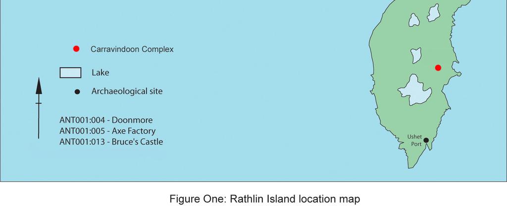
3 1. Summary 1.1. Background Archaeological excavations were undertaken within a complex of hut circles and field systems at Carravindoon as part of the Rathlin Island Research Project from the 24 th May to 18 th June 2004 (Figure One). The project was undertaken by the Centre for Archaeological Fieldwork (Queen s University Belfast) in partnership with the Centre for Maritime Archaeology (University of Ulster Coleraine) on behalf of the Environment and Heritage Service: Built Heritage The excavation at Carravindoon represented part of the second phase of work on the island, designed to augment the results of earlier fieldwork carried out by the Centre for Maritime Archaeology (UUC) over the course of two years. In this particular case the main aim was to retrieve dating evidence for the complex Excavation Three test trenches were opened, all lying within the landscape of curvilinear field boundaries, enclosures and circular huts which stretches across an area approximately 250m 2. Situated towards the southern extremity of the field system was a sub-triangular enclosure, 27m north - south by 25m east - west, bounded partly by low linear banks, and partly by the natural topography. Within this enclosure are four apparent hut sites, the largest of which measures 2.3m north-south by 2.9m east-west internally, defined by a bank 1.9m wide and 0.65m (maximum) high Trench One A trench 8m long (east-west) by 1m (north-south) was opened across the west bank of the largest feature within the enclosure. Apart from a few fragments of flint, one of which was worked, no archaeological features were identified Trench Two Trench Two was opened in the second of three potential hut circles, and was located approximately 150m north-west of Trench One. This was a circular hut site visible as a low bank with some stones protruding through the topsoil. It measured 7.8m externally, 3.0m internally in diameter, and 0.45m in internal height before excavation. A trench 5m long (east - west) by 1m (north - south) was opened across the west bank. This trench also included a small portion of an adjacent field boundary (1.3m wide and 0.3m high), 2
4 which terminated close to the hut wall. On removal of the topsoil the wall of the hut was exposed, revealing tumble on both sides Hut Interior Three main phases of activity were recorded in the interior of the hut. The earliest was represented by a cobbled surface, from which two sherds of coarse pottery and some flint fragments were recovered. The pottery has been assigned a Bronze Age date, with one sherd considered to be possibly part of a Neolithic Globular Bowl (Roche, pers comm.). A hearth was associated with these deposits and close to the wall. Finds associated with the hearth feature comprised flint fragments and two further sherds of coarse pottery Field Boundary The field boundary crossed the south-west corner of the trench diagonally and was formed by an irregular arrangement of natural field boulders. Charcoal and burnt orange earth was recorded in the soil between the stones Trench Three A 2 x 1m trench was opened south-west of Trench One to investigate one of the smaller hut sites within the Carravindoon Complex. The trench was orientated to maximize the potential of uncovering archaeological remains, with the northern half of the trench opened within the hut interior and over the structural wall, and the southern half located to investigate the hut exterior Hut Interior On the removal of topsoil a structural wall feature was uncovered. This was similar to the wall recorded within the upper strata of Trench Two. However, the wall within Trench Three had easily definable edges (particularly on the east side). The upper deposits within the hut interior did not produce any artefacts or features of archaeological significance. However, the base deposit was situated on top of a possible metalled surface and contained several struck flints the most significant of which was a thin blade that possibly dates to the late Mesolithic or Early Neolithic (McCarten pers comm.). 3
5 4
6 2. Background 2.1 General The following report presents the results of the archaeological excavation within the Carravindoon complex, Rathlin Island. The excavations were undertaken as part of the Rathlin Island Research Project from 24 th May to 18 th June 2004, by the Centre for Archaeological Fieldwork (Queens University, Belfast) in partnership with the Centre for Maritime Archaeology (University of Ulster Coleraine). The Rathlin Island Research Project was commissioned by Environment and Heritage Service: Built Heritage Background Two previous field seasons involving a coastal survey had been undertaken by the Centre for Maritime Archaeology (UUC), during which approximately 200 sites were mapped and documented around the shores of the island. The project aimed to examine the whole island from a maritime perspective, and as a consequence a number of sites were targeted for investigation. The excavation at Carravindoon represents a second phase of research, designed to augment existing knowledge of the maritime environment. Other sites investigated within this second phase of work were: Oweyberne Cave (AE/04/96: CAF DSR 026). Oweydoo Cave (AE/04/93: CAF DSR 033). Portcastle (AE/04/92: CAF DSR 032) The three test trenches opened within the Carravindoon Complex lie within a landscape of curvilinear field boundaries, enclosures and hut circles stretching across an area of land approximately 250m² (Plate One). Although a hut circle and two small enclosures (SMR No. ANT 001:018) had been noted during previous fieldwork, the recent survey identified the complex as much more extensive, apparently pre-dating the relic fields shown on the Ordnance Survey maps. The complex is sited on rough grazing land with intermittent rock outcrops and damp, boggy hollows. The land slopes gradually down towards the shore c.100m to the east, which consists of coarse shingle along the upper beach level, and rock towards High Water Mark. Three potential hut sites were chosen for small-scale investigation. Huts One and Three were located within a sub-triangular enclosure at the southern extremity of the field system, in which a total of four possible huts were identified. The enclosure, measuring 27m north south by 25m east west, was bounded by a low linear field bank of earth and stone on the north side, a natural ridge (apparently augmented by a low intermittent bank) on the south-east, and a natural rock outcrop at the south-west. Three of the possible huts lie along the south-western 5
7 side, at the base of the outcrop. Trench three was laid out across the middle hut. A fourth, slightly larger, hut (Trench One) was sited at the north-eastern end of the ridge Approximately 150m north-west of Trench One, and within the wider field system, is a circular hut, 7.8m in external, and 3.0m in internal diameter. Before excavation it stood to a maximum (external) height of 0.46m at the west, and 0.9m at the east, beyond which the ground continues to slope down towards the shore. The internal bank height was recorded as 0.45m. Trench Two was placed east - west across the western bank of this hut. The remnant of a curving field boundary c.1.3m in average width and 0.3m in height, initially appeared to abut the edge of the hut on the western side. It continues for 4.3m approximately west-south-west, before curving south-west, merging with a natural rocky ridge, at which point it becomes difficult to detect Other Sites in the Vicinity The coastal strip along this part of the island has been used extensively during the 18 th and 19 th centuries for the draining and burning of kelp, two rectangular kelp kilns (*MRA 3:45 and 3:47) were recorded at proximity to the field system, just above the beach. In addition, a small boat shelter (MRA 3:46) of uncertain date was identified a short distance (c.50m) to the south of the complex. Some later stone boundaries and field enclosures have been superimposed on the earlier field system A D-shaped enclosure, traditionally believed to be an ancient graveyard known as Kilvoruan (SMR No. ANT 001:017) is located approximately 300m to the north-west of the complex, and within the same townland Research Objectives The main aim of the excavation at Carravindoon was to attempt to recover secure dating evidence for the site, and, if possible, to retrieve any additional information regarding the nature of settlement. Originally it had been hoped to establish the relationship between the hut at Trench Two and the adjacent field boundary; however, this was not possible within the limitations of the investigation. It was also hoped to ascertain if the huts had been built over successive periods, or if they constituted a larger contemporary settlement. * MRA: Maritime Record Antrim - presently held by the Centre for Maritime Archaeology (UUC) 6
, and the Centre for Maritime Archaeology (University of Ulster at")
8 2.5. Archiving Copies of this report have been deposited with Environment and Heritage Service: Built Heritage. All site records and finds are temporarily archived within the School of Archaeology and Palaeoecology (Queen s University Belfast), and the Centre for Maritime Archaeology (University of Ulster at Coleraine) Credits and Acknowledgments The excavation was directed by Peter Moore and Rosemary McConkey. The excavation team consisted of Keith Adams, Brian Sloan, Clare McGranaghan, Eamon Donaghy and Naomi Carver Assistance during the course of the excavation and preparation of this report was kindly provided by: Dr Colm Donnelly and Ruth Logue (CAF), Dr Colin Breen, Tom McErlean and Wes Forsythe (CMA), Sinéad McCartan (UM), Dr Brian Williams (EHS: Built Heritage) and Helen Roche. Plate One: Aerial photograph with the enclosures and hut sites marked. (Surveyed and produced by James Patience and David Wilson, EHS: Built Heritage) 7
9 3. Excavation 3.1. Methodology The programme of work at Carravindoon involved 3 separate test trenches, all of which were located across potential hut structures The excavation of the archaeological strata was undertaken by hand using standard context recording methods. The principal site records consisted of context sheets, field notes and a drawn record. Individual features were photographed and planned, both prior to and following excavation. A series of overall plans (Scale 1:20) were prepared, with section drawings (Scales 1:10 and 1:20) made on completion of the excavation. For details of site photography see Appendix Three and for details of field illustrations see Appendix Four. In addition, separate registers were kept for small finds (Appendix Five) and samples (Appendix Six). It is recommended that the Harris Matrix for the trench is consulted when reading the account of the excavation (see Appendix Two). The unique site code used to identify the records generated during the excavation was CI Account of the excavations Trench One Trench One measured 1m north - south and 8m east - west across the western bank of a potential hut site. Immediately below the topsoil (C.101) was a mid-brown humic loam (C.102) containing many tightly-packed small to medium sized stones, with some larger boulders also located at this level. Fragments of natural flint and one worked piece showing retouch were the only finds recovered from this context. Towards the base of C.102 the mid-brown loam appeared darker in colour and contained fewer roots. Although otherwise similar to C.102, it was given a separate context number (C.103). Situated beneath C.103 was natural subsoil (C.104: Figure Two) containing many stones. No occupation level was detected, and the tightly-packed natural beach stones continued to a depth of c.2m, when excavation was stopped Trench Two Trench Two measured 5m north - south and 1m east - west, and was positioned to include the western bank of the hut-site and part of the adjacent field boundary (Plate Two). The excavation can be sequenced into three phases: Phase One appears to date to the later Middle Bronze Age. Phase Two represents deposits dating to the Later Bronze Age, and is associated with a hearth and two sherds of pottery. 8
10 Phase three is characterized by evidence of burning above Phase Two, and is of uncertain date Hut Interior On removal of topsoil (C.201) a layer of mid-dark brown silty loam (C.203) containing stones, charcoal, burnt orange flecks and some flint fragments was recorded. The surface of C.203 sloped towards the east, and a thin lens of light brown silty loam (C.207), partially overlay C.203 at the eastern side of the trench. This layer (C.207) contained some stones but no finds, and may represent soil which had filtered down from the upper level (some animal burrows were noted at the edges of the trench). Situated beneath C.203 was a layer of compacted, dark brown, silty loam (C.213) containing small stones, burnt earth and charcoal flecks. It was similar in colour and content to C.203 but was more compacted. A sub-angular hearth (C.212 and C.214) 0.47m in length, 0.20m (maximum) width and with a varying depth of 0.03 to 0.14m was situated within C.213. The hearth was clearly visible as bright orange burnt earth with charcoal (c.40%: Plate Three). Although some stones were situated around the edges of the hearth, especially at the north-eastern and south-western ends, they did not appear to represent a formal setting. A struck and possibly worked flint was recovered from between two of the stones beside the hearth (Small Find No. 2: Plate Four), and two sherds of pottery were also recovered from this context (Plate Five). Small Find No. 3 was a sherd of coarse pottery with large inclusions, recovered towards the eastern end of the trench. It was subsequently assigned a Later Middle Bronze Age date. Small Find No. 4 was a sherd of coarse pottery recovered from a slightly higher position than Small Find No. 3 towards the north-eastern corner of the trench. Based on the fabric, this sherd was considered to be from a globular bowl belonging to the Neolithic period (Roche, pers comm.). However, its position in the trench poses obvious problems with this interpretation. In addition some pieces of rough natural flint were collected from this layer Situated below C.213, was a layer of closely-spaced rounded stones (C.218). These stones were typically c.70mm in length and formed a reasonably level cobbled surface (Figure Three: Plate Six). The stones (many of which were beach stones) were compacted in mid-brown silty soil. Two sherds of pottery (Small Find Nos. 5 and 7: Plate Seven), together with a struck flint fragment (Small Find No. 6) were recovered from the surface of the cobbled floor. Small Find No. 5 and Small Find No. 7 have both been dated to the Later Middle Bronze Age (Roche, pers comm.). Situated beneath C.218 was a thin layer of compacted gravely loam (C.221) and more gravely layer (C.222). The trench within the hut interior was excavated to the natural bedrock (C.228). 9
11 3.2.5 Hut Wall Carravindoon, Rathlin Island (Licence No. AE/04/97) The substantial hut wall (C.202) was formed by medium and large-sized natural boulders, with fairly loose silty soil between them. A number of boulders to the east and west of the wall represented collapse. Tumbled stone was cleared in the process of excavation on both sides of the wall, but the stones comprising the central core of the wall were left in situ. No facing stones could be identified, and the wall appears to have been constructed by piling the stones and boulders to form a dry-stone rubble wall. The foundation course was most apparent in section on the interior side of the hut (Figure Four) Field Boundary Wall The low field wall (C.219) running across the south-western corner of the trench was formed by an irregular arrangement of natural field boulders (Plate Eight). Context 215, containing charcoal and burnt orange flecks, was found to run between and under the stones in the field wall Hut Exterior Directly below topsoil (C.201) a layer of fine orange-brown silty loam containing very occasional charcoal flecks and natural flint fragments was recorded (C.204). One struck flint (Small Find No. 8) was recovered from this layer, found between the stones on the outer side of the hut wall. Two lenses were recorded in C.204: C.205 and C.211, it is possible that these deposits represent the remains of truncated post-holes. Context 215, an orange-brown silty loam containing charcoal and burnt orange flecks lay below C. 204 the more frequent charcoal inclusions within C.215 comprised the main difference from C.204. Rough pieces of flint were recovered from throughout C.215. Two contexts (220 and 225) were recorded immediately beneath C.215 and above the natural bedrock. The only distinguishing feature between these was the notably higher stone content in C.220. Context 225 was located adjacent to the (exterior) hut wall, while the relatively stone free C.220 lay beside it further west. The stones in C.220 were generally small and loose, but some larger ones were firmly embedded. Situated beneath C.220 was a small cut feature 0.16m long, 0.08m wide and 0.01m in depth (C.227), filled with an orange-brown silty loam (C.226), this feature may represent the truncated remains of a post-hole. A small oval feature (C.223 and C.224), 0.16m long, 0.07m wide and 0.03m in depth was recorded within C.225, below the hut wall tumble. This may also represent the truncated remains of a post-hole or a footprint for an upright (Figure Five) Trench Three Trench Three measured 1 metre (approximately north south) and 2.2 metres (approximately east west), and was situated to the south-west of Trench One. 10
12 3.2.8 Hut Interior Despite the small size of the test trench, a series of archaeological deposits were recorded that provided evidence for prehistoric activity. Situated immediately above the subsoil layer (C.310), was a layer 0.05m in depth of small rounded and sub-rounded stones (C.309). It is possible that this deposit represents a metalled surface, similar to the cobbling recorded in Trench Two. Situated immediately above C.309 was a dark brown slightly sticky loam with charcoal inclusions 0.20m in depth (C.308). This deposit yielded all of the small finds six artefacts, all of which were flint associated with the excavation of Trench Three (Plate Nine). Small Find No. 4 was a long flint blade with a possible retouched edge, and Small Find No. 6 was a scraper which also had a retouched edge. The rest of the flints are probably debitage, however, it is possible that they date to the Early Neolithic (McCarten, pers comm). Context 305 was situated immediately above C.308 and was 0.16m in depth. Context 305 was also a dark brown loam with charcoal inclusions. However, this deposit was more friable, but there were no artefacts associated with its excavation. Situated within C.305 was a lens of orange clay (C.304) and charcoal (C.303). However, when excavated these deposits were millimeters in depth and were not visible in section. It is likely that they have an association with an episode of burning, but they are unlikely to represent an in situ hearth All of the lower deposits described above were contained within a roughly circular alignment of large stones forming the wall of the hut (C.302; Plate Ten; Figure Six). The largest of these stones was 0.92m (north south) and 0.38m (east west). This wall was situated immediately beneath the topsoil layer (C.301) which was approximately 0.46m in depth Hut Exterior A layer of stones - slump material associated with the main hut wall was situated beneath the topsoil layer (C.301) on the hut exterior (south end of the trench). This was situated above C.307, an archaeologically sterile deposit similar in nature to topsoil 0.42m in depth. Context 307 was situated immediately above subsoil (C.310). 11
13 Figure Two: West section of Trench One. 12
 Plate Two: Trench Two before excavation.")
14 Carravindoon, Rathlin Island (Licence No. AE/04/97) Plate Two: Trench Two before excavation. Plate Three: Hearth (C.212) within Trench Two. 13
 Plate Four: Small Find No.")
.")

15 Carravindoon, Rathlin Island (Licence No. AE/04/97) Plate Four: Small Find No. 2 - flint recovered from beside the hearth (Trench Two). Plate Five: Pot sherds recovered from beside the hearth (Trench Two). Left Possible Neolithic Globular Bowl. Right Pot sherd from the Later Middle Bronze Age. 14
.")
16 Figure Three: Plan of Trench Two showing the cobbled floor surface. Plate Six: Cobbled floor surface (C.218: Trench Two). 15


17 Plate Seven: Pot sherds recovered from the cobble surface (C. 218: Trench Two). Figure Four: Trench Two south section showing the hut wall (C.202). 16

18 Plate Eight: The field boundary wall. Figure Five: Plan showing the hut exterior and possible upright footprint. 17
.")
19 Plate Nine: Flints recovered from the hut interior (Trench Three). Figure Six: Trench Three east facing section. 18


20 Plate Ten: Hut wall (C.302) in Trench Three. 19
21 4. Discussion 4.1. Conclusion Trench One Traces of a circular bank, partially overlapping the enclosure ridge, were superficially apparent before excavation. However, apart from one struck flint, no evidence for occupation could be found. The few larger stones noted in the upper part of the trench were considered to possibly represent the last remnant of a wall structure, but on the basis of this test trench little can be contributed to the overall evaluation of the complex Trench Two The excavation of the hut in Trench Two revealed a sequence of occupation. However, the periods between successive phases may not have been long. Indeed, it is suggested by the dating of the pottery that a relatively short time may have elapsed between the occupation levels represented by C.213 and C Pottery An obvious problem arises from the proposed Neolithic date for the pottery sherd found in C.213. This context is evidently later than C.218, and yet the two sherds found in the latter belong to the later Middle Bronze Age. One possibility is that the anomaly reflects disturbance of the site, but the stratigraphy was otherwise clear-cut throughout the eastern portion of the trench, and, apart from some rabbit burrows noted in the upper levels, there was no evidence of disturbance. The sherd attributed to the Neolithic period is coarse, and its identification tentative. Given the circumstances of the find, it seems more plausible that it actually belongs to a later period Hut Interior Based on the pottery evaluation, the earliest occupation in the area inside the hut was during the Middle Bronze Age, as was the second phase. The fact that both these horizons occurred at a level below the apparent base of the hut wall would suggest that either the floor level in the hut was deliberately lowered - possibly to provide more shelter or insulation or that the two earlier phases of occupation pre-date the construction of the hut wall. This might explain the position of the hearth which was located close to the side of the hut, rather than the more usual central setting. The question then arises whether any of the possible post or stake-holes found outside the hut area might relate to one of these earlier phases. Certainly, C.205, 208, 210 and C.211 would seem to be at a relatively high level, either contemporary with or later than the use of the stone-built hut. The position of C.223/224 might be more feasibly argued. None of the potential stake- 20
22 holes could be seen to form a regular arc or consistent pattern, which might be more indicative of a hut or shelter Hut Exterior Some evidence for early activity was identifiable in the small shallow spread (C. 226 and C.227) containing flecks of charcoal, just above the natural bedrock to the west of the hut. This feature was too small to have been the remains of a fire, and its relationship, if any, to the sequence in the hut interior is unknown. Its date, function and significance remain uncertain. While admittedly the trench was limited in extent, it may be possible to obtain an estimate for the lowest original height of the hut wall using the drawing and photographic record of the tumble in the trench. The position of the potential stake-holes, i.e. on the outside of the hut wall and removed from it, rather than against the interior wall, would suggest that they were not used to support any form of superstructure connected with the hut. Such a detached external structure would seem very flimsy and vulnerable to the elements, although this would perhaps be less of a problem if occupation was limited to summer seasons Trench Three The deposits excavated in Trench Three suggest that this slightly smaller structure would also have functioned as a hut site. The upper levels within the hut interior were archaeologically unproductive. However, the small finds recovered from the lower levels suggest a possible Neolithic construction date. If this is the case, it is possible that the remains of the structure recorded in Trench Three pre-dates the hut site recorded in Trench Two. The layer of cobbling uncovered (C.309) would indicate that there was a sunken floor level. This construction technique could have provided additional shelter in what can still be a harsh island environment. There was no evidence for a hearth contemporary with the hut structure, although it is possible that the trench did not penetrate deep enough into the hut interior to record any such feature Hut Exterior The deposits recorded on the hut exterior (south end of the trench) were archaeologically sterile. Evidence for slump associated with the stone wall was recorded beneath the topsoil layer. However, there does not appear to have been any associated activity located around the hut perimeter Carravindoon Complex Looking at the complex as a whole, if the flints recovered from Trench Three are Neolithic in character, the enclosure containing the cluster of huts to the south of Trench Two would probably not have been occupied at the same time as the latter. This might be 21
23 more in keeping with small-scale sporadic occupation over a long period, rather than a larger contemporary settlement. It is tempting to suggest that occupation at Carravindoon was seasonal, perhaps involving summer grazing or intermittent farming. The small size of the huts would seem to argue for short-term, rather than permanent habitation. In the context of the whole island, however, it should be noted that there is evidence of longterm settlement during the Bronze Age elsewhere. This appears to date mainly to the Early Bronze Age, in the form of at least four possible round cairns and a cist cemetery. One of the round cairns that contained bones was located in Carravindoon townland. Other Bronze Age finds, including two Late Bronze Age gold ornaments from Ushet and Ballynagard, and some flat-rimmed pottery, also point to settlement on the island. Coarse pottery dating to the Bronze Age was recovered from Knockans (Shandragh) further to the north-west, among a range of material attesting to settlement there from the Neolithic period. Recent excavation in Oweyberne Cave also uncovered Bronze Age pottery fragments, together with possible Bronze Age occupation levels (CAF DSR 026). 22
24 5. Recommendations for Future Work 5.1 Introduction The results of the 2004 excavation within the Carravindoon Complex justify detailed and full publication. However, it is important that this is undertaken in conjunction with the findings of the preceding field surveys, together with the findings of the other excavations undertaken in 2004 as part of the Rathlin Island Research Project. Consequently, it is recommended that a programme of post-excavation analysis is undertaken In order to satisfactorily complete the post-fieldwork analysis and prepare publication, the following tasks have been identified, (an outline of the anticipated costs for the completion of this work can been seen in the Costed Assessment [CAF CA 031] that accompanies this document). 5.2 Programme of radiocarbon dating Given that there appears to have been little disturbance of the archaeological strata within Trench Two and Three, it would be worthwhile pursuing radiocarbon dates for several of the deposits. The hearth from Trench Two (C.212), together with charcoal samples obtained from the upper levels (C.203) would clarify the dates for the phases of occupation on the site. The charcoal from the lower deposit within Trench Three (C.308) would provide an ideal sample for dating the second hut structure that was excavated. It is therefore recommended that three radiocarbon dates are ascertained to give secure dates for the structures within the Carravindoon Complex. 5.3 Environmental analysis The sample taken from the hearth in Trench Two should be floated and analyzed in order to ascertain whether there is evidence for charred grain, seeds or other environmental remains that may augment the information obtained through the excavation programme. 23
25 Appendix One: Context Log Trench One Context Context 101 Context 102 Context 103 Context 104 Description Mid-brown humic loam (topsoil) Stony layer below topsoil Probably the same as context C.102, but slightly darker Dark brown soil containing stones - subsoil Trench Two Context Description Context 201 Upper soil layer below sods Context 202 Stones comprising hut wall Context 203 Mid dark brown silty loam. Context 204 Layer below C201 on the exterior (W side) of the hut wall. Orangebrown silty loam Context 205 Mid-brown feature in C.204. This is a cut filled by C.208. It is triangular with a rounded base possible stake-hole. 130mm long, 105mm wide and c.10mm deep Context 206 Mid-brown feature in C.204. Irregularly-shaped cut filled by C.209. Context 207 Mid-brown lens in hut interior Context 208 This is the fill from C.205 above. Mid light brown loam Context 209 The fill from C.206. Brown silty loam Context 210 Fill of a small dark oval feature - C.211 in C.204. Dark brown silty loam, small amounts of burnt orange flecks and charcoal. Context 211 The cut filled by C.210. Oval shaped cut with rounded base, 160mm by 135mm across, and c.85mm deep Context 212 Fill of Hearth (C.214) near the interior hut wall. Contains compacted burnt orange earth and charcoal in a solid sub-angular block. Context 213 Similar to C.203, but more compacted, in interior of hut. Charcoal, pottery & flint from this level. Context 214 Cut containing fill C.212 hearth in interior of hut. It is 47cm long, 20cm wide at NE and 13cm wide at SW. The depth is 6cm at NE and 3cm at SW. Hearth looks angular, but the cut is more sub-oval in plan. Context 215 Underneath C.204, and is similar in consistency, contains charcoal and burnt orange flecks. Context 216 This is the fill of C.217. Brown silty loam. Context 217 Cut of C.216. Roughly U-shaped, 50cm N-S by 35cm E-W. Context 218 Cobbled floor in hut interior, below C.213. Occasional charcoal flecks, coarse pottery and flint came from this level. Context 219 Low stone field wall, located at the W. end of the trench, extended down to the base of C.215. Context 220 Mid-dark brown fairly loose silty loam below C.215. Frequent small stones. Context 221 Thin layer of compacted gravelly soil between C.218 and C.222. Context 222 Layer of compacted gravelly soil below C.221 Context 223 Fill of cut C.224, an oval feature in C.225. Darker (possibly charcoal stained) soil. Context 224 Cut containing Fill C.223. It is shallow, oval, 16cm long, 7cm wide and 3cm deep. 24
26 Context Description Context 225 Mid-brown silty loam to W. of hut wall. At same level, but to E. of C.220 Context 226 Fill of C.227, below C.220. Shallow spread of orange-brown, silty loam with charcoal flecks Context 227 Cut containing fill C cm long, 8cm wide and 1cm deep. Context 228 Natural bedrock Trench Three Context Context 301 Context 302 Context 303 Context 304 Context 305 Context 306 Context 307 Context 308 Context 309 Context 310 Description Mid brown loam topsoil layer Large stones forming the core of the hut wall (also slumped towards the interior and exterior of the hut) Charcoal concentration associated with orange clay and located within C.305 Orange clay (burnt earth) associated with charcoal and located within C.305 Dark brown loam 0.20m in depth Deleted Archaeologically sterile deposit (similar to topsoil) located on the hut exterior Dark brown slightly sticky loam situated immediately above C.209. Contained all the artifacts recovered within Trench Three Closely packed stones probably forming a metalled floor surface Natural subsoil layer 25
27 Appendix Two: Harris Matrix (Trench One) 101 Topsoil Natural beach boulder Subsoil 26
28 Appendix Two: Harris Matrix (Trench Two) Hut wall Hearth Field boundary wall Cobbled floor surface Bedrock 27
29 Appendix Two: Harris Matrix (Trench Three) 301 Sterile deposit located to the hut exterior Hut Wall Metalled Surface 310 Subsoil 28
30 Appendix Three: Photographic Record Photograph No. Trench Description 01 One Trench position across the bank & hut site 02 One Hut site looking west 03 One Carravindoon enclosure from W. looking east 04 One Carravindoon enclosure from W. looking E. (N. bank visible on left) 05 One Sod-removal 06 One Topsoil removed looking at C.102 stony layer 07 One Looking seaward from E side of enclosure 08 One Surface of context C One As above 10 One As above 11 One Sondage in upper, east part of trench 12 One 1.3m deep after excavation 13 One Section showing possible base of hut wall 14 One As above 15 One Natural stones raised beach 16 One Natural stones raised beach 17 Two Hut site. Trench position before excavation 18 Two As above 19 Two As above 20 Two As above 21 Two As above 22 Two Context Two As above 24 Two Context 202 hut wall 25 Two As above 26 Two As above 27 Two As above 28 Two Stones in trench, and in the field wall 29 Two Field wall running towards hut 30 Two View from the west 31 Two Detail of field wall and edge of hut 32 Two Field wall 33 Two Detail of hut wall and collapse 34 Two Detail of hut wall & collapse interior (E.) 35 Two Edge of hut interior wall from E. 36 Two Floor of interior of hut 37 Two Floor of hut (context C203) lower level 38 Two As above 39 Two Exterior of hut (C.204) with 2 small possible stake-holes 40 Two As above 41 Two As above 42 Two Sub-rectangular hearth at/below the base of the hut wall (interior) 43 Two As above 44 Two As above 45 Two As above 46 Two Hearth just inside the hut wall 47 Two Small sub-circular hut built against a field bank 48 Two As above 49 Two Field wall - diagonally across the SW corner of trench 29
31 Photograph No. Trench Description 50 Two Field wall - diagonally across the SW corner of trench 51 Two As above 52 Two Hut wall from E. 53 Two Interior of the hut after the hearth (C.212) was removed 54 Two C.213 at the E end 55 Two Small find No. 3 from C Two E. end top of layer C.218 before some tumbled stone was removed 42 Two As above 57 Two As above 58 Two As above 59 Two C.217 & fill C.216 Section after half of the feature was taken out 60 Two As above 61 Two As above 62 Two As above 63 Two Small find No. 7 - Sherd of coarse pottery found among stones in C.218 (cobbled floor) 64 Two As above 65 Two As above 66 Two Cobbled floor C Two As above 68 Two Field wall (C.219) exposed & continuing to run N.W. 69 Two As above 70 Two C.219 after the top stones were removed 71 Two As above 72 Two As above 73 Two Interior of hut when C.218 (cobbled floor) had been removed 74 Two As above 75 Two C.220 under C Two As above 77 Two As above 78 Two E. end showing C Two As above from E. 80 Two As above 81 Two Section of the E. end of trench, S side, showing C.201, C.203, C.207, C.213, C.218, C.221, C Two As above 83 Two Top of section of the E. end 84 Two Section of hut wall from E. 85 Two As above 86 Two Section N-S showing the hut wall and the hearth 87 Two As above 88 Two Interior of hut wall 89 Two W. end of trench 90 Two C.226 and C Two C.226 and C.227 bedrock exposed around the feature 92 Two Middle section of trench from N showing hut wall 93 Two As above 94 Two W. end of trench after excavation of feature C.226 / C Two W. end of trench cleaned up with bedrock exposed 96 Two Section of trench (N. side) 97 Two Final section (N. side) 30
32 Photograph No. Trench Description 98 Two As above 100 Two Final section (S. side) 101 Two As above 102 Two As above 103 Two Final section W. end 104 Two Final section N. side 105 Two As above 106 Two Final section E. end 107 Two As above 108 Two Final section across trench N. S. 109 Two Final section (S. side) 110 Two Natural 111 Two Plan just W. of hut wall 112 Two As above 113 Two Base section W. of hut wall 114 Two Plan of W. end of trench 115 Three C.302 (after topsoil removal) 116 Three As above 117 Three As above 118 Three As above 119 Three C.305 interior of hut 120 Three As above 121 Three C.307 exterior of hut 122 Three As above 123 Three C.302 after stones have been cleaned 124 Three C.302 facing stones (E.) 125 Three As above 126 Three C.308 before excavation 127 Three C.308 after excavation 128 Three C.309 metalled surface 129 Three C.310 natural subsoil 31
33 Appendix Four: Field Drawing Register Trench One Trench Drawing Type Description 1 Plan Plan of Trench after excavation 1 Section Section of trench Trench Two Trench Drawing Type Description 2 Plan Plan of C.201 and C Plan Plan showing C.202, C.203, C.204 and C.207, with features C.205 and C.206 cleaned up 2 Plan Plan showing C.210/C.211 the small stake-hole on the W. side of the trench, outside the hut 2 Plan Plan showing the E. end of the trench, C.212/C.214, the hearth inside the hut, against the W. wall 2 Plan Plan showing the metalled floor (C.218) in the interior of the hut, and the rest of the trench outside the hut (C.202, C.216/C.217, C.215, C Plan Plan showing C Plan Plan showing C.220 and C.225 which lie at the same level; also the wall 2 Plan Plan showing C.226/C.227 feature patch of orange-brown soil with orange flecks & charcoal under C.220 and above bedrock 2 Section Profile taken N.-S. across the trench, showing the position of the hearth (C.212/C.214) in relation to the top of the trench 2 Section Profile E.-W. across the trench, showing the position of the hearth (C.212/C.214) in relation to the end of the trench 2 Section Profile of feature C.216/C.217 after the fill had been taken out 2 Section Profile S.-N. across C.218 cobbled floor 2 Section Profile E.-W. across C.218 cobbled floor 2 Section Profile S.-N. across C.218 cobbled floor after further cleaning up 2 Section Section of E. side of trench, showing stratigraphy from the top to natural at the base 2 Section Interior of hut wall drawn from E. looking W. across the wall. N.-S. section across the trench showing wall & hearth 2 Section North-facing Section showing hut wall (especially W. side) 2 Section South-facing Section showing western end of Trench Trench Three Trench Drawing Type Description 3 Plan C.308 (hut wall) also showing C.305 and C Section W. section showing C.301, C.302, C.307, C.308, C.309,C Plan Base of trench showing subsoil 32
34 Appendix Five: Finds Register Trench One Trench Context Small Find No. Description 1 C.102 N/A Flint fragments - mostly from the W. half (hut exterior) One rough piece from E. side 1 C.103 N/A Flint pieces, some very rough; possibly struck; one worked piece 1 C.103 N/A Small, worked flint with some retouch visible Trench Two Trench Context Small Find No. Description 2 C.201 N/A Mixed Flint throughout this layer 2 C.203 N/A Charcoal from darker soil near the interior hut wall. 2 C.203 N/A Flints from the area containing charcoal 2 C.204 Small Find # 1 Flint 2 C.213 Small Find # 2 Struck flint from C.213 between two stones beside the hearth, and at the hearth level 2 C.213 Small find # 3 Sherd of coarse, thick pottery with inclusions 2 C.213 N/A Flints 2 bags 2 C.213 N/A Charcoal 2 C.213 Small Find # 4 Sherd of coarse pottery from the side of the trench, at a slightly higher level than Small find # 3 2 C.215 N/A Charcoal (Sample # 10) from the area of the field wall (C.219) 2 C.216 N/A Piece of rough flint from the fill of feature C.217 under wall tumble (outside hut) 2 C.213/C.218 Small find # 5 Sherd of coarse, undecorated pottery with cordon, from between stones at the interface between C.213 and C.218, hut interior. 2 C.218 Small find # 6 Flint from among the stones on the surface of the cobbled floor 2 C.218 N/A Flints from the surface, and within C.218, hut interior. 2 C.218 Small find # 7 Sherd of coarse undecorated pottery from the surface of the cobbled floor, hut interior. 2 C.215 N/A Flints from throughout C C.204 Small find # 8 Flint found in C C.219 N/A Flints from the field wall C.219, at the level of C C.219 N/A Flints from the field wall (C.219) at the level of C C.219/C.215 N/A Flints from between the stones in the field wall (C.219) at level of C
35 Trench Three Trench Context Small Find No. Description Carravindoon, Rathlin Island (Licence No. AE/04/97) 3 C.308 Small Find # 1 Struck flint fragment 3 C.308 Small Find # 2 Possible flint scraper 3 C.308 Small Find # 3 Possible small flint blade 3 C.308 Small Find # 4 Long flint blade possible retouch 3 C.308 Small Find # 5 Worked flint fragment 3 C.308 Small Find # 6 Flint scraper - retouched 34
36 Appendix Six: Soil Sample Register Trench Two Sample No. Context No. Description 01 C.208 Mid-light brown loam 02 C.203 Charcoal derived from within C C.209 Brown silty loam fill of C C.203 Mid-dark brown silty loam 05 C.210 Dark brown silty loam 06 C.212 Burnt earth and charcoal derived from the hearth 07 C.216 Brown silty loam 08 C.218 Charcoal from the top of the cobbled layer 09 C.216 Brown silty loam 10 C.215 Charcoal and burnt earth from C.215 Trench Three Sample No. Context No. Description 01 C.304 Orange burnt earth 02 C.305 Dark brown loan (hut interior) 03 C.308 Dark brown slightly sticky loam (charcoal inclusions) 35
Oweydoo Cave, Rathlin Island Rathlin Island Research Project AE/04/93
 Centre for Archaeological Fieldwork School of Archaeology & Palaeoecology Queen s University Belfast & Centre for Maritime Archaeology School of Environmental Science University of Ulster Coleraine Data
Monitoring Report No. 022 GREENCASTLE BURIALS GREEN CASTLE COUNTY DOWN LICENCE NO. N/A PHILIP MACDONALD
 Monitoring Report No. 022 GREENCASTLE BURIALS GREEN CASTLE COUNTY DOWN LICENCE NO. N/A PHILIP MACDONALD Monitoring Report No. 022 Greencastle Burials (SMR No. Down 057:017) Greencastle Co. Down Philip
Evaluation/Monitoring Report No. 259
 SITE 100M EAST OF 16 LEARMORE ROAD CASTLEGORE CASTLEDERG COUNTY TYRONE LICENCE NO.: AE/13/36E NAOMI CARVER 1 Site Specific Information Site Name: 100m east of 16 Learmore Road, Castlederg, Co. Tyrone Townland:
Evaluation/Monitoring Report No. 152
 Evaluation/Monitoring Report No. 152 150m west of 7 Portmore Rd. Portmore Lower Ballinderry County Antrim LICENCE NO.: AE/07/241 David McIlreavy 1 Site Specific Information Site Name Townland County :
Former transport depot, Charlton Road, Charlton, Shepperton, Surrey
 Former transport depot, Charlton Road, Charlton, Shepperton, Surrey An Archaeological Evaluation for St James Homes Ltd by Steve Ford Thames Valley Archaeological Services Ltd Site Code CRC06/117 June
Bramley Grange, Horsham Road, Bramley, Surrey
 Bramley Grange, Horsham Road, Bramley, Surrey An Archaeological Evaluation for English Villages Housing Association by Stephen Hammond Thames Valley Archaeological Services Ltd Site Code BGB 03/95 October
Archaeology of East Oxford Project: Minchery Paddock 2012 Trench 1 Excavation Narrative report
 Archaeology of East Oxford Project: Minchery Paddock 2012 Trench 1 Excavation Narrative report Julian Stern and Olaf Bayer Introduction & Summary Trench 1 was the northern most of three trenches excavated
Land adjacent to 103 Pound Lane, Sonning, Berkshire
 Land adjacent to 103 Pound Lane, Sonning, Berkshire An Archaeological Evaluation for Hicks Development Ltd by James McNicoll-Norbury Thames Valley Archaeological Services Ltd Site Code PLS 09/50 June 2009
Archaeological Monitoring. at Johnstown, Enfield, Co. Meath.
 Licence No: 01E0367 Archaeological Monitoring at Johnstown, Enfield, Co. Meath. By Ruth Elliott Client High Degree Construction June 2001 LIST OF CONTENTS Contents Page 1. Introduction 4 2. Historical
With an Appendix by Brian Sloan, Centre for Archaeological Fieldwork, Queen s University, Belfast
 Supplement to Report No. 52 Henry Welsh Surface Artefact Collection Ballytaylor County Antrim With an Appendix by Brian Sloan, Centre for Archaeological Fieldwork, Queen s University, Belfast 2 Ulster
General Editor: Vince Russett
 YCCCART 2014/Y20 North Somerset HER 2015/11 Manual survey using an electronic, hydryostatic level (NIVCOMP) at Wemberham Roman Villa YATTON, CONGRESBURY, CLAVERHAM AND CLEEVE ARCHAEOLOGICAL RESEARCH TEAM
Archaeological Monitoring Report
 Archaeological Monitoring Report High Lodge, Santon Downham SMR Nos. STN 067, STN 068 A REPORT ON THE ARCHAEOLOGCAL MONTORNG, 2002 Andrew Tester Field Team Suffolk C.C. Archaeological Service November
APPENDIX B: REPORT ON GEOPHYSICAL SURVEY, JULY 1998
 APPENDIX B: REPORT ON GEOPHYSICAL SURVEY, JULY 1998 by Andy Payne Introduction A geophysical survey was carried out at Le Yaudet, Ploulec h, Brittany as part of the ongoing investigation into the archaeology
The Rising Sun, Guildford Road, Fetcham, Surrey
 The Rising Sun, Guildford Road, Fetcham, Surrey An Archaeological Evaluation for Bovis Homes Limited by Steve Ford Thames Valley Archaeological Services Ltd Site Code RGF04/80 March 2005 Summary Site name:
Figure 45. Plan of Pukaroro drawn from aerial photograph. K. Jones, drawn by C. Edkins, DOC.
 Figure 45. Plan of Pukaroro drawn from aerial photograph. K. Jones, drawn by C. Edkins, DOC. 101 length, and there are cross-rows forming semi-enclosures. House floors are also present at the southern
Assessment of biological remains from excavations at Newbridge Quarry, Pickering, North Yorkshire (site code: NBQ99)
") Reports from the Environmental Archaeology Unit, York 2000/27, 5 pp. Assessment of biological remains from excavations at Newbridge Quarry, Pickering, North Yorkshire (site code: NBQ99) by Allan Hall,
Reports from the Environmental Archaeology Unit, York 2000/27, 5 pp. Assessment of biological remains from excavations at Newbridge Quarry, Pickering, North Yorkshire (site code: NBQ99) by Allan Hall,
Former Cart Shed, Stroud Farm, Holyport, Maidenhead, Berkshire
 Former Cart Shed, Stroud Farm, Holyport, Maidenhead, Berkshire An Archaeological Watching Brief For Mr Simon Rinder by Stephen Hammond and Jennifer Lowe Thames Valley Archaeological Services Ltd Site Code
Former PLA Recreation Ground, The Drive, Ilford, London Borough of Redbridge
 Former PLA Recreation Ground, The Drive, Ilford, London Borough of Redbridge An Archaeological Evaluation for CgMs Ltd by Steve Ford Thames Valley Archaeological Services Ltd Site Code FPL06 May 2006 Summary
Land at Model Farm Cottages, Bath Road, Sonning, Berkshire
 Land at Model Farm Cottages, Bath Road, Sonning, Berkshire An Archaeological Evaluation for The Keen Partnership by Andy Taylor Thames Valley Archaeological Services Ltd Site Code BRS 04/55 June 2004 Summary
Summers Place, Stane Street, Billingshurst, West Sussex
 Summers Place, Stane Street, Billingshurst, West Sussex An Archaeological Evaluation for Berkeley Homes (Southern) Ltd by Simon Cass Thames Valley Archaeological Services Ltd Site Code SPB 07/33 March
Long Ashes Holiday Park Threshfield North Yorkshire
 on behalf of GVA Humberts Leisure for Lakeland Leisure Estates Ltd Long Ashes Holiday Park Threshfield North Yorkshire archaeological evaluation report 3027 December 2012 Contents 1. Summary 1 2. Project
S E R V I C E S S O U T H
 T H A M E S V A L L E Y ARCHAEOLOGICAL S E R V I C E S S O U T H The orthbrook Site, West Durrington, Worthing, West Sussex Area B Archaeological Evaluation by Sean Wallis Site Code: CW11/113 (TQ 1070
Acrefield Cottage, Winkfield Street, Maidens Green, Winkfield, Windsor, Berkshire
 Acrefield Cottage, Winkfield Street, Maidens Green, Winkfield, Windsor, Berkshire An Archaeological Watching Brief For Mr and Mrs Elia by Pamela Jenkins Thames Valley Archaeological Services Ltd Site Code
Archaeological Evaluation of Land off Hubbards Lane, Boughton Monchelsea, Kent
 Archaeological Evaluation of Land off Hubbards Lane, Boughton Monchelsea, Kent NGR: 576190 151300 Site Code: HUB/EV/16 (Planning Application: 16/500014/OUT/MA) SWAT Archaeology The Office, School Farm
Geophysical Survey. Ballymount Co. Dublin. Licence Ref. 02R029. By John Nicholls Margaret Gowen & Co. Ltd. For LRT
 Geophysical Survey Ballymount Co. Dublin Licence Ref. 02R029 By John Nicholls Margaret Gowen & Co. Ltd. For LRT 4 th April 2002 Illustrations List of Figures Figure 1 Site Location 1: 50000 Figure 2 Survey
Centre for Archaeological Fieldwork
 Centre for Archaeological Fieldwork School of Geography, Archaeology and Palaeoecology, QUB CAF Data Structure Report: No. 111 Excavations at Dunluce Castle, Co. Antrim Andrew Gault and Grace McAlister
Roman Farm, Nettleden, Hemel Hempstead, Hertfordshire
 Roman Farm, Nettleden, Hemel Hempstead, Hertfordshire An Archaeological Watching Brief for Mercantile Land Development Ltd by Siân Anthony Thames Valley Archaeological Services Ltd Site Code RFN01/82 October
ARCHAEOLOGICAL METHOD FEHMARN STYLE
 ARCHAEOLOGICAL METHOD FEHMARN STYLE Digital archaeology By: Nadja M. K. Mortensen, Prehistoric Archaeologist, Responsible for GIS Overview of the survey area Digital measuring and registration are an important
25 Whiteknights Road, Reading, Berkshire
 25 Whiteknights Road, Reading, Berkshire An Archaeological Evaluation for B & M Care by Sean Wallis Thames Valley Archaeological Services Ltd Site Code WRR07/74 July 2007 Summary Site name: 25 Whiteknights
Land at Larchwood Farm, Whitehorse Lane Finchampstead, Berkshire
 Land at Larchwood Farm, Whitehorse Lane Finchampstead, Berkshire An Archaeological Evaluation for Mr. John Westbrook by James McNicoll-Norbury Thames Valley Archaeological Services Ltd Site Code LFF08/103
181 London Road, Isleworth, London Borough of Hounslow
 181 London Road, Isleworth, London Borough of Hounslow An Archaeological Evaluation for Crest Nicholson Residential (South) Ltd by Jo Pine and Andy Taylor Thames Valley Archaeological Services Ltd Site
Whitelands College, West Hill, Putney, London Borough of Wandsworth
 Whitelands College, West Hill, Putney, London Borough of Wandsworth An Archaeological Evaluation for Crest Nicholson Residential (South) Ltd by Sian Anthony Thames Valley Archaeological Services Ltd Site
Excavations at Clocken Syke Farm, Dairy Lane,Dacre By Nidderdale Iron-age Archaeology community group 2015 and 2016
 Excavations at Clocken Syke Farm, Dairy Lane,Dacre By Nidderdale Iron-age Archaeology community group 2015 and 2016 1 Introduction The Nidderdale Iron-Age group and its forerunners have been investigating
Appletree Bay, Scilly Isles
 Appletree Bay, Scilly Isles Record ID 662 NMR Amongst shoreline boulders on the south side of the bay. Seven small peat beds visible as two main fragmentary groups (part of old land surface). Pitted and
APPENDIX L.3 ARCHAEOLOGICAL MONITORING REPORT (JOHN CRONIN & ASSOCIATES)
") Grousemount Wind Farm, Co. Kerry Environmental Impact Statement - Volume 2 of 3 August 2015 APPENDIX L.3 ARCHAEOLOGICAL MONITORING REPORT (JOHN CRONIN & ASSOCIATES) Appendix L: Cultural Heritage Barnastooka
Grousemount Wind Farm, Co. Kerry Environmental Impact Statement - Volume 2 of 3 August 2015 APPENDIX L.3 ARCHAEOLOGICAL MONITORING REPORT (JOHN CRONIN & ASSOCIATES) Appendix L: Cultural Heritage Barnastooka
Redgrave Pinsent Rowing Lake, Caversham Lakes, Henley Road, Caversham, Oxfordshire
 Redgrave Pinsent Rowing Lake, Caversham Lakes, Henley Road, Caversham, Oxfordshire An Archaeological Evaluation: Phase 2 for Mott McDonald Ltd by Sarah Coles and Sian Anthony Thames Valley Archaeological
Thames Valley University, Kings Road, Reading, Berkshire
 Thames Valley University, Kings Road, Reading, Berkshire An Archaeological Evaluation for Thames Valley University by Danielle Milbank and Steve Ford Thames Valley Archaeological Services Ltd Site Code
Archaeological Evaluation at Howt Green Farm, Sheppey Way, Bobbing, Kent
 Archaeological Evaluation at Howt Green Farm, Sheppey Way, Bobbing, Kent NGR: 589575 166122: Site Code: HGF-EV-14 (Planning Reference: SW/13/0501) Date of Report: 11/04/14 Amended 07/05/2014 SWAT Archaeology
Oxford Bus Company Depot, Cowley Road, Oxford
 Oxford Bus Company Depot, Cowley Road, Oxford An Archaeological Evaluation (Stage 2) for Berkeley Homes (Oxford and Chiltern) Ltd by Jo Pine Thames Valley Archaeological Services Ltd Site Code GAG 00/32
Archaeological Monitoring of Land at Seacrest, Cliff Drive, Warden, Isle of Sheppey, Kent
 Archaeological Monitoring of Land at Seacrest, Cliff Drive, Warden, Isle of Sheppey, Kent Site Code SEA/WB/15 Report for Kevin & Lesley O Brian Date of report 14/10/2015 SWAT ARCHAEOLOGY Swale and Thames
Collfryn Ring-ditch, Guilsfield, Powys
 CPAT Report No 1122 TRIAL EXCAVATION 2011 THE CLWYD-POWYS ARCHAEOLOGICAL TRUST CPAT Report No 1122 TRIAL EXCAVATION 2011 I Grant December 2011 Report for Cadw The Clwyd-Powys Archaeological Trust 41 Broad
Land off Luton Road, Farley Hill, Luton, Bedfordshire
 Land off Luton Road, Farley Hill, Luton, Bedfordshire An Archaeological Evaluation for 3Sixty Construction Ltd by Andrew Mundin Thames Valley Archaeological Services Ltd Site Code LRL 08/82 August 2008
Geophysical Survey Report No. 8 Killyglen Co. Antrim
 Geophysical Survey Report No. 8 Killyglen Co. Antrim Dr Steven Trick Geophysical Survey Report No. 8 Dr Steven Trick April 2006 1 Introduction 1.1 This report presents the results of a third geophysical
Charlmont Road, Tooting, London Borough of Wandsworth
 123-125 Charlmont Road, Tooting, London Borough of Wandsworth An Archaeological Evaluation For Eramo Developments Limited by Andrew Weale and Andrew Taylor Thames Valley Archaeological Services Ltd Site
Centre for Archaeological Fieldwork Evaluation Report No. 292
 Centre for Archaeological Fieldwork Evaluation Report No. 292 Dundrum Castle Car Park Co. Down AE/14/211E Philip Macdonald, Queen s University Belfast Site Specific Information Site Name: Dundrum Castle
Oxford Options Resource Centre, Horspath Driftway, Headington, Oxford
 Oxford Options Resource Centre, Horspath Driftway, Headington, Oxford An Archaeological Watching Brief For Oxfordshire County Council by Tim Dawson and Heather Hopkins Thames Valley Archaeological Services
Report on Geophysical Survey Na Vrsku, Sahy, Slovakia Coordinates: 48⁰,4,45 N 18⁰,56,23 E. April 2018
 Report on Geophysical Survey Na Vrsku, Sahy, Slovakia Coordinates: 48⁰,4,45 N 18⁰,56,23 E April 2018 Mark Graham BA(Hons), BSc, MA Grampus Heritage and Training Ltd, Ashgill, Threapland, Wigton, Cumbria,
GEOPHYSICAL SURVEY REPORT. Timolin, County Kildare. Date: 18/01/2016. Licence: 15R0133
 GEOPHYSICAL SURVEY REPORT Date: 18/01/2016 Licence: 15R0133 J. M. Leigh Surveys 124 Oaklawn West Leixlip County Kildare www.jmlsurveys.com 01 615 4647 Consultants. J. M. Leigh Surveys 124 Oaklawn West,
Centre for Archaeological Fieldwork School of Archaeology & Palaeoecology Queen s University Belfast
 Centre for Archaeological Fieldwork School of Archaeology & Palaeoecology Queen s University Belfast Geophysical Survey Report: No. 001 St Jarlath s Church 1 1. Summary 1.1 A combined geophysical and topographical
T H A M E S V A L L E Y S E R V I C E S. Land between 138 and 142 Southcote Lane, Reading, Berkshire. Archaeological Evaluation
 T H A M E S V A L L E Y ARCHAEOLOGICAL S E R V I C E S Land between 138 and 142 Southcote Lane, Reading, Berkshire Archaeological Evaluation by James McNicoll-Norbury Site Code: SLR09/121 (SU 6935 7215)
ARCHAEOLOGICAL S E R V I C E S. 6a Old Mill Way, Shirley, Southampton, Hampshire. Archaeological Evaluation. by Daniel Bray. Site Code: SOU 1640
 T H A M E S V A L L E Y ARCHAEOLOGICAL S E R V I C E S 6a Old Mill Way, Shirley, Southampton, Hampshire Archaeological Evaluation by Daniel Bray Site Code: SOU 1640 (SU 3934 1442) 6a Old Mill Way, Shirley,
AN ARCHAEOLOGICAL SURVEY FOR THE EASTHAM STATE PRISON FARM UNIT PROJECT IN HOUSTON COUNTY TEXAS
 AN ARCHAEOLOGICAL SURVEY FOR THE EASTHAM STATE PRISON FARM UNIT PROJECT IN HOUSTON COUNTY TEXAS Antiquities Permit 5693 By William E. Moore and Edward P. Baxter Brazos Valley Research Associates Contract
December 13, Kirk Shields Green Mountain Power 163 Acorn Lane Colchester, VT 05446
 December 13, 2017 Kirk Shields Green Mountain Power 163 Acorn Lane Colchester, VT 05446 RE: End of Field Letter for Archaeological Phase II Site Evaluation at Site VT-CH-1218 within the Proposed Milton
The Upper Paleolithic Longwangcan Site at Yichuan in Shaanxi
 The Upper Paleolithic Longwangcan Site at Yichuan in Shaanxi The Institute of Archaeology, Chinese Academy of Social Sciences Shaanxi Provincial Institute of Archaeology Key words: Longwangcan site; microliths;
CHAPTER 4. Blue Heron Site (47Je1001) 2003 Investigations. By Chrisie L. Hunter
 2003 Investigations. By Chrisie L. Hunter") CHAPTER 4 Blue Heron Site (47Je1001) 2003 Investigations By Chrisie L. Hunter Introduction The Blue Heron site (47Je1001) is on the property of the Crescent Bay Hunt Club, which is located in the NE 1/4
CHAPTER 4 Blue Heron Site (47Je1001) 2003 Investigations By Chrisie L. Hunter Introduction The Blue Heron site (47Je1001) is on the property of the Crescent Bay Hunt Club, which is located in the NE 1/4
EXCAVATION OF AN ENCLOSURE SITE AT ROSSNAREE, (BRÚ NA BÓINNE) CO. MEATH. 10E0242
 CO. MEATH. 10E0242") Preliminary Report Committee for Archaeology Royal Irish Academy EXCAVATION OF AN ENCLOSURE SITE AT ROSSNAREE, (BRÚ NA BÓINNE) CO. MEATH. 10E0242 Preliminary Report, Excavation 2011 Conor Brady Department
Preliminary Report Committee for Archaeology Royal Irish Academy EXCAVATION OF AN ENCLOSURE SITE AT ROSSNAREE, (BRÚ NA BÓINNE) CO. MEATH. 10E0242 Preliminary Report, Excavation 2011 Conor Brady Department
S E R V I C E S. The Vicarage, Victoria Square, Lee-on-the-Solent, Hampshire. Archaeological Watching Brief. by Ellen McManus-Fry. Site Code: VVL16/97
 T H A M E S V A L L E Y ARCHAEOLOGICAL S E R V I C E S The Vicarage, Victoria Square, Lee-on-the-Solent, Hampshire Archaeological Watching Brief by Ellen McManus-Fry Site Code: VVL16/97 (SU 5618 0093)
King s Knot, Stirling. Data Structure Report Radar Profile Survey
 King s Knot, Stirling Data Structure Report Radar Profile Survey August 2012 REPORT INFORMATION SHEET National Grid Reference NS 78896 93646 Address Parish Council NMRS King s Knot Park, Stirling Stirling
New Sunday School, St Mary s Church, White Waltham, Maidenhead, Berkshire
 New Sunday School, St Mary s Church, White Waltham, Maidenhead, Berkshire An Archaeological Evaluation for White Waltham and Shottesbrook Parochial Church Council by Simon Cass Thames Valley Archaeological
Appendix 2 - List of Units according to Grid Square
 Appendix 2 - List of Units according to Grid Square Includes units excavated in previous seasons but discussed in the report Explanation of s Disturbance Deposits dating to the period of disturbance at
Plate 51. Site 035. Collection of remains. Scale is in cm. Plate 50. Site 034. Collection of remains. Scale is in cm
 Plate 48. Site 033. View facing north west Plate 49. Site 034. View facing north Pottery Pottery Ostrich eggshell Plate 50. Site 034. Collection of remains. Scale is in cm Plate 51. Site 035. Collection
Archaeological Excavations at Bolton Hill Quarry, Pembrokeshire
 Archaeological Excavations at Bolton Hill Quarry, Pembrokeshire Excavations at Bolton Hill revealing in plan one of the numerous hearth-pits identified on the site ARS Ltd Report No 2010/50 August 2010
LAND ADJACENT TO COLESHALL FARM/ SHEPPEY WAY/SCHOOL LANE, IWADE, KENT
 LAND ADJACENT TO COLESHALL FARM/ SHEPPEY WAY/SCHOOL LANE, IWADE, KENT January 2012 Prepared for: Hillreed Homes Limited, Hillreed House, 60 College Road Maidstone, Kent ME15 6SJ SWAT Archaeology The Office,
ARCHAEOLOGICAL S E R V I C E S. 1 Beechmount Road, Southampton, Hampshire. Archaeological Watching Brief. by David Platt. Site Code: SOU1649
 T H A M E S V A L L E Y ARCHAEOLOGICAL S E R V I C E S 1 Beechmount Road, Southampton, Hampshire Archaeological Watching Brief by David Platt Site Code: SOU1649 (SU 4188 1616) 1 Beechmount Road, Southampton,
ARCHAEOLOGICAL S E R V I C E S. Kingsley Academy, Prince Regent Road, Hounslow, London Borough of Hounslow. Archaeological Evaluation
 T H A M E S V A L L E Y ARCHAEOLOGICAL S E R V I C E S Kingsley Academy, Prince Regent Road, Hounslow, London Borough of Hounslow Archaeological Evaluation by James McNicoll-Norbury Site Code: CCL15/173
Barbuda Historical Ecology Project Assessment for Qualitative Field Analysis of Phosphates on Barbuda
 Barbuda Historical Ecology Project 2009 Assessment for Qualitative Field Analysis of Phosphates on Barbuda Cory Look Anthropology Department Brooklyn College and CUNY Graduate Center CLook@gc.cuny.edu
Diddenham Court, Grazeley, Reading, Berkshire, Phase 2
 Diddenham Court, Grazeley, Reading, Berkshire, Phase 2 An Archaeological Watching Brief For Fenchurch Estates (Diddenham) Ltd by Steve Hammond and Simon Cass Thames Valley Archaeological Services Ltd Site
CHAPTER 3. Field work
 CHAPTER 3 Field work 3.1. Introduction It is clear from the typological range of stone tools found on Bloubos that the environmental setting on the farm facilitated occupation over many millennia. In particular
Pumping Station, Whytelaydes Lane, Cookham Rise, Berkshire
 Pumping Station, Whytelaydes Lane, Cookham Rise, Berkshire An Archaeological Evaluation for Gullett and Sons Ltd by Simon Cass Thames Valley Archaeological Services Ltd Site Code WLC 07/156 November 2007
Gransmoor Quarry, Gransmoor, East Riding of Yorkshire
 Gransmoor Quarry, Gransmoor, East Riding of Yorkshire An Archaeological Evaluation for W. Clifford Watts Ltd. by Andrew Weale Thames Valley Archaeological Services Ltd Site Code GQY07/32 March 2007 Summary
This Unit is suitable for candidates with no previous archaeological experience but who have an interest in history and/or archaeology.
 National Unit specification: general information Unit code: H29B 12 Superclass: DC Publication date: August 2012 Source: Scottish Qualifications Authority Version: 01 Summary This Unit introduces candidates
5 The Geophysical Survey
 5 The Geophysical Survey As a preliminary to the evaluation work at Castle Hill a geophysical survey was undertaken by Bath and Camerton Archaeological Society aided by members of the AFG on the 4 th and
Foxburrow Farm Solar Array, Brightwell BGL 050
 Foxburrow Farm Solar Array, Brightwell BGL 050 Archaeological Evaluation Report SCCAS Report No. 2014/001 Client: UK Sustainable Energy Ltd. Author: Simon Cass March 2014 Suffolk County Council Archaeological
Dunknock Hillfort Excavations Data Structure Report. by Chris Dalglish, Olivia Lelong, Gavin MacGregor & Dave Sneddon
 Dunknock Hillfort Excavations 2009 Data Structure Report by Chris Dalglish, Olivia Lelong, Gavin MacGregor & Dave Sneddon Photo Crown Copyright RCAHMS -1- Table of Contents Summary 3 Introduction 3 Location
Participants: Arjen Heijnis, Maria Mertiri (Aarhus University), Silke Eisenschmidt (Museum Sønderjylland).
, Silke Eisenschmidt (Museum Sønderjylland).") Excavation report (sb. 104 Broager sogn) Author: Arjen Location: WGS84 6.171.967 538.417 Landowner: Andelsselskabet Smøl vold (chairman Jørn Christensen) Date: 13-9-2015 Participants: Arjen, Maria Mertiri
Excavation report (sb. 104 Broager sogn) Author: Arjen Location: WGS84 6.171.967 538.417 Landowner: Andelsselskabet Smøl vold (chairman Jørn Christensen) Date: 13-9-2015 Participants: Arjen, Maria Mertiri
Archaeological Reconnaissance Survey of. Boundary, North Kona, Island of Hawai i (TMK:7 2 04:05)
") T. S. Dye & Colleagues, Archaeologists, Inc. 735 Bishop St., Suite 315, Honolulu, Hawai i 96813 Archaeological Reconnaissance Survey of Proposed Project Area on Kūki o 1st-Kūki o 2nd Boundary, North Kona,
T. S. Dye & Colleagues, Archaeologists, Inc. 735 Bishop St., Suite 315, Honolulu, Hawai i 96813 Archaeological Reconnaissance Survey of Proposed Project Area on Kūki o 1st-Kūki o 2nd Boundary, North Kona,
Culham Court, Aston, Remenham, Berkshire
 Culham Court, Aston, Remenham, Berkshire An Archaeological Evaluation for Woody Clark Limited by Sean Wallis Thames Valley Archaeological Services Ltd Site Code CCA 07/117 October 2007 Summary Site name:
LONG PRESTON DEEPS, RIBBLESDALE, NORTH YORKSHIRE
 LONG PRESTON DEEPS, RIBBLESDALE, NORTH YORKSHIRE Archaeological Watching Brief Oxford Archaeology North October 2011 ENVIRONMENT AGENCY Issue No: 2011 12/1231 OA North Job No: L10410 NGR: SD 8110 6090
Wangford Quarry, Proposed Southern Extension, Wangford with Henham, Suffolk
 ARCHAEOLOGICAL EVALUATION REPORT SCCAS REPORT No. 2011/002 Wangford Quarry, Proposed Southern Extension, Wangford with Henham, Suffolk WNF 029 Jezz Meredith June 2011 www.suffolkcc.gov.uk/environment/archaeology
Swaledale and Arkengarthdale Archaeology Group
 Swaledale and Arkengarthdale Archaeology Group Bellerby Moor GPS Earthwork Survey Report prepared by: Tim Laurie and Stephen Eastmead. Swaledale and Arkengarthdale Archaeology Group. January 27/01/2012.
Ground Penetrating Radar Survey of a Portion of East End Cemetery, Cadiz, Kentucky
 Ground Penetrating Radar Survey of a Portion of East End Cemetery, Cadiz, Kentucky January 2011 Report prepared by Anthony L. Ortmann, Ph.D. Assistant Professor Department of Geosciences Murray State University
Centre for Archaeological Fieldwork School of Geography, Archaeology and Palaeoecology Queen s University Belfast
 Centre for Archaeological Fieldwork School of Geography, Archaeology and Palaeoecology Queen s University Belfast Data Structure Report No. 075 Excavations at a Scheduled Enclosure site, (ANT 047:068)
Archaeological Evaluation and Assessment of Land at Roselands, Sedlescombe, East Sussex
 Archaeological Evaluation and Assessment of Land at Roselands, Sedlescombe, East Sussex NGR: TQ 78013 18096 Site Code: ROSE/EV/16 (Planning Application: RR/2015/2248/P) SWAT Archaeology The Office, School
Geophysical Survey of Wisconsin Burial Site BRO-0033 Wixom Cemetery, Rock County, Wisconsin
 Lawrence University Lux Archaeological Reports Anthropology Department 6-2015 Geophysical Survey of Wisconsin Burial Site BRO-0033 Wixom Cemetery, Rock County, Wisconsin Peter N. Peregrine Lawrence University
Stratigraphy: Establishing a Sequence from Excavated Archaeological Evidence
 Stratigraphy: Establishing a Sequence from Excavated Archaeological Evidence THE PRINCIPLES OF STRATIGRAPHY In order to explain how and why cultural and social forms change through time, archaeologists
BUTE MAP 6: GARROCH HEAD to STRAVANNAN BAY
 BUTE MAP 6: GARROCH HEAD to STRAVANNAN BAY Hinterland Geology and Coastal Geomorphology: Old Red Sandstone and lavas form the principal base deposits and are overlain by marine deposits towards Port Dornoch.
Report on the Geophysical survey undertaken at Kouphovouno between 28 th June and 2 nd July.
 Report on the Geophysical survey undertaken at Kouphovouno between 28 th June and 2 nd July. Introduction: A team comprising of two undergraduate students (Anna Moles & James Taylor) and two postgraduates
Built Heritage & Archaeology Crown copyright. All rights reserved. Historic Scotland Licence No [2007] a
![Built Heritage & Archaeology Crown copyright. All rights reserved. Historic Scotland Licence No [2007] a](/thumbs/92/110316004.jpg "Built Heritage & Archaeology Crown copyright. All rights reserved. Historic Scotland Licence No [2007] a") : Tràigh an Tobair Fhuair to Meall Lamalum This map section stretches along s west coast from Tràigh an Tobair Fhuair to Meall Lamalum. The entire coastline comprises a rock platform, with the exception
: Tràigh an Tobair Fhuair to Meall Lamalum This map section stretches along s west coast from Tràigh an Tobair Fhuair to Meall Lamalum. The entire coastline comprises a rock platform, with the exception
Land at Arden Heath Farm. Stratford-upon-Avon. Warwickshire. Archaeological Evaluation Report. October 2013
 Land at Arden Heath Farm Stratford-upon-Avon Warwickshire Archaeological Evaluation Report October 2013 Client: Gallagher Estates Issue No: 1 OA Job No: 5747 NGR: SP 223 546 Archaeological Evaluation Report
Map 12: Ayrshire Coast: Doonfoot Beach to Dunure Map Content Descriptions
 Map 12: Ayrshire Coast: Doonfoot Beach to Dunure Map Content Descriptions 1. Built Heritage and Archaeology A total of twenty three sites were located in the area covered by Map 12. Of these seventeen
Geophysical Surveys at Moncrieffe Hill Fort, Perthshire
 Geophysical Surveys at Moncrieffe Hill Fort, Perthshire P.Morris Site Type FORT Canmore ID 28058 Site Number NO11NW 7 NGR NO 1313 1988 Council PERTH AND KINROSS Parish DUNBARNEY Geophysical Surveys at
Starting at Rock Bottom
 Starting at Rock Bottom At rock bottom of the Brushy Creek site s geological column lies the first clue to human habitation: A smelting and heattreating furnace, and mold, carved into Bed Ked: Figure 15
Relative Dating Introduction: Types of Relative Dating:
 Relative Dating Introduction: In the early stage of prehistoric studies, dating of any event or site was obtained tentatively. A particular event or specimen is dated in relation to other event or some
Glossary of Common Terms. Guide 2. BAJR Practical Guide Series held by authors
 Glossary of Common Terms Guide 2 BAJR Practical Guide Series 2008 held by authors Glossary of common archaeological terms : compiled 28/04/2004 absolute dating: Absolute dating is based upon a specific
Shotover View, Craufurd Road, Oxford
 Shotover View, Craufurd Road, Oxford An Archaeological Evaluation for Oxfordshire County Council by James Lewis Thames Valley Archaeological Services Ltd Site Code: CRO07/169 July 2008 Summary Site name:
Ground Penetrating Radar Survey Report: Follow-up Ground Truth Study
 Ground Penetrating Radar Survey Report: Follow-up Ground Truth Study 2005 Tell es-safi/gath Archaeological Project Figure 1: Tell es-safi GPR ground-truth study. Data Acquired August 4, 2005 Report compiled
HISTORY OF CONSTRUCTION FOR EXISTING CCR SURFACE IMPOUNDMENT PLANT GASTON ASH POND 40 CFR (c)(1)(i) (xii)
(1)(i) (xii)") HISTORY OF CONSTRUCTION FOR EXISTING CCR SURFACE IMPOUNDMENT PLANT GASTON ASH POND 40 CFR 257.73(c)(1)(i) (xii) (i) Site Name and Ownership Information: Site Name: E.C. Gaston Steam Plant Site Location:
HISTORY OF CONSTRUCTION FOR EXISTING CCR SURFACE IMPOUNDMENT PLANT GASTON ASH POND 40 CFR 257.73(c)(1)(i) (xii) (i) Site Name and Ownership Information: Site Name: E.C. Gaston Steam Plant Site Location:
Excavations at New Laund Farm, Whitewell, Lancashire, 2014 Draft Interim Report
 Excavations at New Laund Farm, Whitewell, Lancashire, 2014 Draft Interim Report Kayla Carter and Rick Peterson Archaeology School of Forensic and Investigative Sciences University of Central Lancashire
REPORT ON THE SURVEY AND EXCAVATION AT GULUWURU ISLAND: LOOKING FOR S6670 STOKER II PERCIVAL CAMERON. Marc Oxenham, BSc, BA (Hons), PhD, FSA
, PhD, FSA") 1 REPORT ON THE SURVEY AND EXCAVATION AT GULUWURU ISLAND: LOOKING FOR S6670 STOKER II PERCIVAL CAMERON Marc Oxenham, BSc, BA (Hons), PhD, FSA My name is Marc Oxenham. I am a bioarchaeologist. My professional
1 REPORT ON THE SURVEY AND EXCAVATION AT GULUWURU ISLAND: LOOKING FOR S6670 STOKER II PERCIVAL CAMERON Marc Oxenham, BSc, BA (Hons), PhD, FSA My name is Marc Oxenham. I am a bioarchaeologist. My professional
The Soils and Land Capability for Agriculture. Land North of Aberdeen, Aberdeenshire
 The Soils and Land Capability for Agriculture Of Land North of Aberdeen, Aberdeenshire Report prepared for Peter Radmall Associates May 2012 Reading Agricultural Consultants Ltd Beechwood Court, Long Toll,