6. Overturned Rim Sequence
|
|
|
- Hector Wright
- 5 years ago
- Views:
Transcription
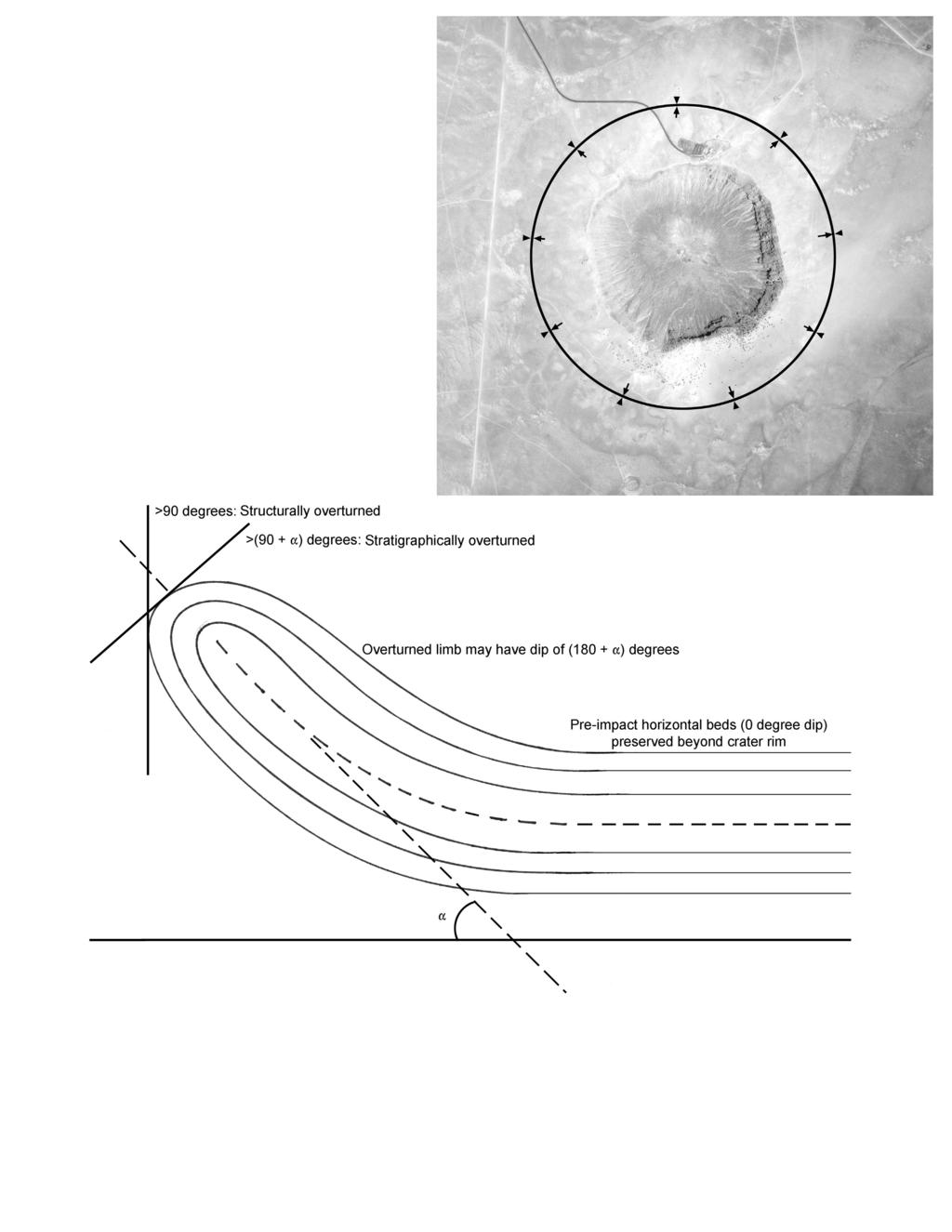
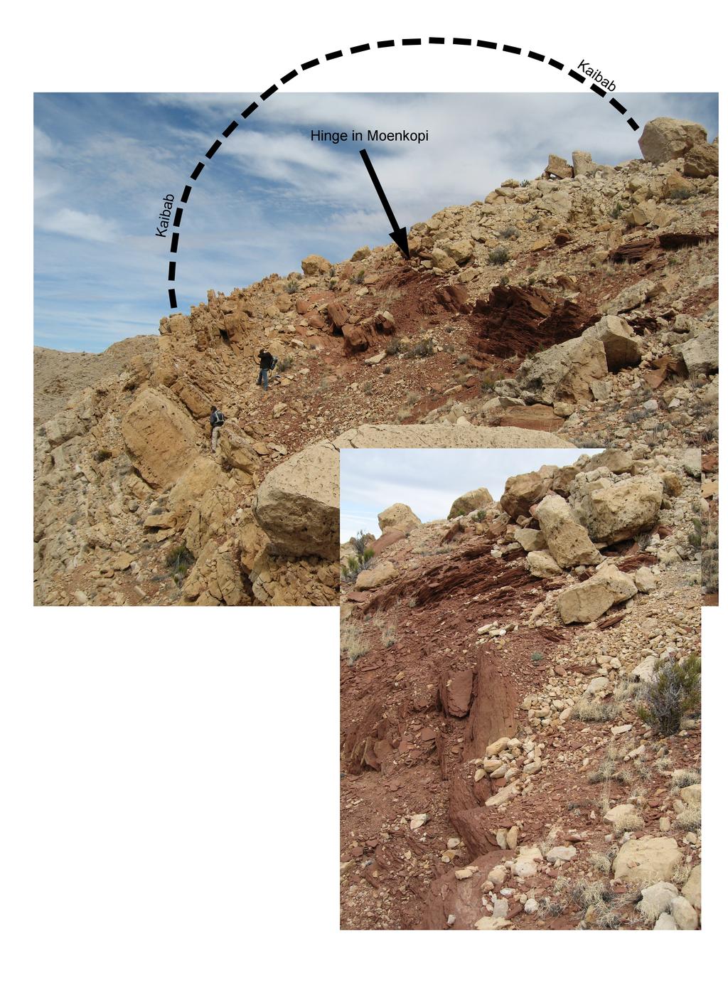
1 6. Overturned Rim Sequence Shock pressures overwhelm the material strength of rock in the immediate vicinity of an impact event. Thus, rock under the influence of shock does not behave in the immovable, brittle fashion that we normally assign to it. The excavation flow (Fig. 3.7 and 3.8) that generated the crater produced a nearly instantaneous folding of the bedrock in the rim of the crater, which is partly responsible for the height of the rim above the surrounding plain. Structural overturning of the strata was noted by Barringer (1910) in the northwest corner of the crater:... the strata exposed in the walls of the crater gradually increase from 5 degrees up to vertical and in one place they are slightly overturned. In that same paper, he also characterizes the stratigraphic consequences, writing that a deeper sandstone is on top of shallower sandstone, which is on top of even shallower limestone. Shoemaker (1960) pointed out that similar overturned sequences are produced in the rims of nuclear explosion craters (e.g., the crater produced by the ~1 kt Ess or Teapot Ess explosion in 1955). An overturned rim sequence is now recognized as one of the hallmarks of an impact crater. Traditionally, students are introduced to this overturning in a study of the Moenkopi in the northeast rim of the crater, where cross-bedded laminae within the siltstone can be used to identify the overturned sequence. Additional details of those outcrops are provided in the trail guide for the east crater rim (Chapter 14). The overturned sequence can, however, be seen around the entire crater. For example, on the south rim of the crater, one finds the Wupatki and Moqui members of the Moenkopi repeated and overturned (Fig. 6.1). Before examining another example of the overturned sequence, it is perhaps useful to first examine a schematic diagram that illustrates the structural and stratigraphic context of the overturned rim sequence. In structural terms, the overturned rim is a syncline with a circumferential axial trace or compound syncline, because there are actually two folds involved. The first is associated with the uplift and outward tilting of the beds in the crater walls (as described in the last chapter) and the second is with the complete overturning of those strata. With regard to the latter, there are actually two types of overturning evident in the crater rim (Fig. 6.2). Structural overturning occurs when the dips of the beds pass a vertical plane (and, thus, have dips exceeding 90 ). Stratigraphic overturning occurs when the dips of the beds are rotated 90 beyond the outward dip of the lower limb of the fold. Thus, if the outward dip of the rim strata are, say, 35, stratigraphic overturning occurs when the beds exceed dips of 125 ( ). Indeed, some strata will dip 215 ( ) on the overturned upper limb of that fold, relative to their pre-impact orientation. Several locations exist on the east side of the crater where erosion reveals the fold hinge in the Kaibab and Moenkopi units. An example of a fold hinge in Moenkopi is shown in Fig The axial plane is within the fissile Moqui Member of the Moenkopi. In overturned sequences where the hinge is not exposed, it is often difficult to identify the axial plane because of the fissile nature of the Moqui. One often has to rely on the geopetal characteristics of the Wupatki Member to demonstrate the overturned stratigraphic context. This and other fold hinges are included in the trail guide for the east crater rim. The Moenkopi is not everywhere exposed along the upper crater walls, because it is buried within the overturned Kaibab and Coconino. Access to the Moenkopi is facilitated by rim erosion, as illustrated in a series of time-steps in Fig As erosion cuts back into the crater walls, it removes fold hinges in the deeper layers (e.g., Kaibab) and reveals overturned sequences in the shallower layers (i.e., Moenkopi). Folds in both the Kaibab and Moenkopi are evident along the east crater rim. As discussed further in the next chapter, the amount of erosion is still being debated, but Shoemaker (1974) argued that 40 ft (12 m) occurred on the outer flank of the northeast corner of the crater, which suggests a cut back of the inner David A. Kring (2007) LPI Contribution No
2 crater wall probably also occurred in that area. The Moenkopi exposed in upper crater walls will not everywhere be the same thickness. This partly reflects pre-impact topographical relief that existed on the Moenkopi, because it was the eroding surface unit on the landscape. It also is partly the result of structural thinning that occurred during the overturning process, which is manifest in a series of small faults in the overturned rim sequence. The views in Fig. 6.4 are idealized. Hummocky ejecta and crater rays will modify the distribution, which will be discussed further in the next chapter. The amount of erosion that occurs is also variable. Consequently, as one circumnavigates the crater rim, one might be walking on Coconino (as in top panel of Fig. 6.4) or on Kaibab (as in bottom panel of Fig. 6.4). The amount of overturned debris on the rim crest varies accordingly. Roddy (1978) estimated the original rim was covered with ~20 ± 5 m of debris, which is a structurally-thinned remnant of an excavated stratigraphic thickness of at least 88 m (corresponding to Kaibab and Moenkopi, which dominate the exposed rim sequence) and also much less than a total excavated stratigraphic thickness of 300 to 310 m (corresponding to Coconino, Toroweap, Kaibab, and Moenkopi). Currently, 0 to ~20 m of ejected debris survives on the current rim crest, depending on location around the crater. A greater fraction of the uplifted rim is the result of the uplifted strata beneath the overturned debris sequence, which is responsible for ~47 m of the uplift (Roddy, 1978). David A. Kring (2007) LPI Contribution No

3
4
5

6
5. Crater Rim Uplift and Crater Wall Collapse
 5. Crater Rim Uplift and Crater Wall Collapse The basic processes involved in crater rim uplift are understood, but there is a lot of evidence at the crater that has not been fully explored and may eventually
6. Crater Rim Uplift and Crater Wall Collapse
 6. Crater Rim Uplift and Crater Wall Collapse The basic processes involved in crater rim uplift are understood, but there is a lot of evidence at the crater that has not been fully explored and may eventually
Stress and Strain. Stress is a force per unit area. Strain is a change in size or shape in response to stress
 Geologic Structures Geologic structures are dynamically-produced patterns or arrangements of rock or sediment that result from, and give information about, forces within the Earth Produced as rocks change
Chapter 15 Structures
 Chapter 15 Structures Plummer/McGeary/Carlson (c) The McGraw-Hill Companies, Inc. TECTONIC FORCES AT WORK Stress & Strain Stress Strain Compressive stress Shortening strain Tensional stress stretching
1. Introduction. David A. Kring (2007) LPI Contribution No
 LPI Contribution No") 1. Introduction Science does not always move forward in a straight line and rarely at a constant cadence. Studies of Barringer Meteorite Crater (a k a Meteor Crater) is a classic example. Although an immense
1. Introduction Science does not always move forward in a straight line and rarely at a constant cadence. Studies of Barringer Meteorite Crater (a k a Meteor Crater) is a classic example. Although an immense
1. Introduction. David A. Kring (2017) LPI Contribution No
 LPI Contribution No") 1. Introduction Science does not always move forward in a straight line and rarely at a constant cadence. The study of Barringer Meteorite Crater (a k a Meteor Crater) is a classic example. Although an
1. Introduction Science does not always move forward in a straight line and rarely at a constant cadence. The study of Barringer Meteorite Crater (a k a Meteor Crater) is a classic example. Although an
EAS 233 Geologic Structures and Maps Winter Miscellaneous practice map exercises. 1. Fault and separation:
 Miscellaneous practice map exercises 1. Fault and separation: With respect to Map 1, what are (a) the orientation of the fault, and (b) the orientation of bedding in the units cut by the fault. (c) Mark
Answers: Internal Processes and Structures (Isostasy)
") Answers: Internal Processes and Structures (Isostasy) 1. Analyse the adjustment of the crust to changes in loads associated with volcanism, mountain building, erosion, and glaciation by using the concept
Answers: Internal Processes and Structures (Isostasy) 1. Analyse the adjustment of the crust to changes in loads associated with volcanism, mountain building, erosion, and glaciation by using the concept
A. Refer to Appendix F in back of lab manual for list of commonly used geologic map symbols
 Structural Geology Lab 2: Outcrop Patterns and Structure Contours I. Geologic Map Symbols A. Refer to Appendix F in back of lab manual for list of commonly used geologic map symbols 1. Emphasis: a. strike
!'f \, w. Alan Stewart Colorado Exploration Company, Golden STRUCTURE OF THE FOOTHILLS AREA WEST OF DENVER, COLORADO. Introduction
 STRUCTURE OF THE FOOTHLLS AREA WEST OF DENVER, COLORADO w. Alan Stewart Colorado Exploration Company, Golden ntroduction i ; The dominant structural features west of Denver and along the mountain front
Structural Geology and Geology Maps Lab
 Structural Geology and Geology Maps Lab Mesa College Geology 101 Lab Ray Rector: Instructor Structural Geology Lab Pre-Lab Resources Pre-Lab Internet Links 1) Fundamentals of Structural Geology 2) Visualizing
GEOLOGIC MAPS PART II
 EARTH AND ENVIRONMENT THROUGH TIME LABORATORY - EES 1005 LABORATORY FIVE GEOLOGIC MAPS PART II Introduction Geologic maps of orogenic belts are much more complex than maps of the stable interior. Just
GCE Geology. Mark Scheme for June Unit F791: Global Tectonics. Advanced Subsidiary GCE. Oxford Cambridge and RSA Examinations
 GCE Geology Unit F79: Global Tectonics Advanced Subsidiary GCE Mark Scheme for June 206 Oxford Cambridge and RSA Examinations OCR (Oxford Cambridge and RSA) is a leading UK awarding body, providing a wide
Geologic Structures. Changes in the shape and/or orientation of rocks in response to applied stress
 Geologic Structures Changes in the shape and/or orientation of rocks in response to applied stress Figure 15.19 Can be as big as a breadbox Or much bigger than a breadbox Three basic types Fractures >>>
The NEA Impact that Created Meteor Crater, Arizona
 The NEA Impact that Created Meteor Crater, Arizona David A. Kring USRA - Lunar and Planetary Institute Houston, TX First Proven Impact Crater Daniel M. Barringer Iron meteorites at crater Meteorite abundances
Study the architecture and processes responsible for deformation of Earth s crust. Folding and Faulting
 Crustal Deformation AKA Structural geology (adapted from Brunkel, 2012) Study the architecture and processes responsible for deformation of Earth s crust. Folding and Faulting How Rocks Deform: 4 Controls
Lecture 6 Folds, Faults and Deformation Dr. Shwan Omar
 Fold: A fold is a bend or wrinkle of rock layers or foliation; folds form as a sequence of ductile deformation. Folding is the processes by which crustal forces deform an area of crust so that layers of
Name. GEOL.5220 Structural Geology Faults, Folds, Outcrop Patterns and Geologic Maps. I. Properties of Earth Materials
 I. Properties of Earth Materials GEOL.5220 Structural Geology Faults, Folds, Outcrop Patterns and Geologic Maps Name When rocks are subjected to differential stress the resulting build-up in strain can
CRUSTAL DEFORMATION. Chapter 10
 CRUSTAL DEFORMATION and dgeologic Structures t Chapter 10 Deformation Df Deformation involves: Stress the amount of force applied to a given area. Types of Stress: Confining Stress stress applied equally
What Causes Rock to Deform?
 Crustal Deformation Earth, Chapter 10 Chapter 10 Crustal Deformation What Causes Rock to Deform? Deformation is a general term that refers to all changes in the shape or position of a rock body in response
How mountains are made. We will talk about valleys (erosion and weathering later)
") How mountains are made We will talk about valleys (erosion and weathering later) http://www.ilike2learn.com/ilike2learn/mountainmaps/mountainranges.html Continent-continent plate convergence Less dense,
How mountains are made We will talk about valleys (erosion and weathering later) http://www.ilike2learn.com/ilike2learn/mountainmaps/mountainranges.html Continent-continent plate convergence Less dense,
Lecture 9 faults, folds and mountain building
 Lecture 9 faults, folds and mountain building Rock deformation Deformation = all changes in size, shape, orientation, or position of a rock mass Structural geology is the study of rock deformation Deformation
Structural Geology Lab. The Objectives are to gain experience
 Geology 2 Structural Geology Lab The Objectives are to gain experience 1. Drawing cross sections from information given on geologic maps. 2. Recognizing folds and naming their parts on stereoscopic air
Faults, folds and mountain building
 Faults, folds and mountain building Mountain belts Deformation Orogens (Oro = Greek all changes for mountain, in size, shape, genesis orientation, = Greek for or formation) position of a rock mass Structural
Lab 6: Plate tectonics, structural geology and geologic maps
 Geology 103 Name(s): Lab 6: Plate tectonics, structural geology and geologic maps Objective: To show the effects of plate tectonics on a large-scale set of rocks and to reconstruct the geological history
Lab 7: STRUCTURAL GEOLOGY FOLDS AND FAULTS
 Lab 7: STRUCTURAL GEOLOGY FOLDS AND FAULTS This set of labs will focus on the structures that result from deformation in earth s crust, namely folds and faults. By the end of these labs you should be able
Siva Bharatha Murthy. T Page 4.31
 Importance of Geological Structures: The physical properties of rocks, mineral and other materials of civil engineering, like textures, grain size are very important for a civil engineer. Similarly the
1.8 Ga metamorphic rocks of Mingus Mountain. (Note: All digital images by Prof. C. Merguerian.)
") Geology 143A: Field Course to Northern Arizona Led By: Dr. Charles Merguerian, Chairman, Geology Department Spring 2010 Spring Break (March 27-Apr 3, 2010) Through an integrated lecture and field course,
Geology 143A: Field Course to Northern Arizona Led By: Dr. Charles Merguerian, Chairman, Geology Department Spring 2010 Spring Break (March 27-Apr 3, 2010) Through an integrated lecture and field course,
Landforms and Rock Structure
 Landforms and Rock Structure Rock Structure as a Landform Control Landforms of Horizontal Strata and Coastal Plains Landforms of Warped Rock Layers Landforms Developed on Other Land-Mass Types Landforms
Crustal Deformation. (Building Earth s Surface, Part 1) Science 330 Summer Mapping geologic structures
 Science 330 Summer Mapping geologic structures") Crustal Deformation (Building Earth s Surface, Part 1) Science 330 Summer 2005 Mapping geologic structures When conducting a study of a region, a geologist identifies and describes the dominant rock structures
Crustal Deformation (Building Earth s Surface, Part 1) Science 330 Summer 2005 Mapping geologic structures When conducting a study of a region, a geologist identifies and describes the dominant rock structures
Section 7. Reading the Geologic History of Your Community. What Do You See? Think About It. Investigate. Learning Outcomes
 Chapter 3 Minerals, Rocks, and Structures Section 7 Reading the Geologic History of Your Community What Do You See? Learning Outcomes In this section, you will Goals Text Learning Outcomes In this section,
Continental Landscapes
 Continental Landscapes Landscape influenced by tectonics, climate & differential weathering Most landforms developed within the last 2 million years System moves toward an equilibrium Continental Landscapes
Geomorphology Final Exam Study Guide
 Geomorphology Final Exam Study Guide Geologic Structures STRUCTURAL GEOLOGY concerned with shapes, arrangement, interrelationships of bedrock units & endogenic (within) forces that cause them. Tectonic
Structural Geology, GEOL 330 Fold mapping lab: Even folds get parasites Spring, 2012
 Structural Geology, GEOL 330 Name: Fold mapping lab: Even folds get parasites Spring, 2012 This exercise is meant to mimic a field experience in which you, the student, will measure beddingcleavage relationships
Part I. PRELAB SECTION To be completed before labs starts:
 Student Name: Physical Geology 101 Laboratory #13 Structural Geology II Drawing and Analyzing Folds and Faults Grade: Introduction & Purpose: Structural geology is the study of how geologic rock units
How to Build a Mountain and other Geologic Structures. But first, questions
 How to Build a Mountain and other Geologic Structures But first, questions Questions your students might ask How were Montana s mountains formed? How old are the mountains? What are the different ways
Lecture Outline Friday March 2 thru Wednesday March 7, 2018
 Lecture Outline Friday March 2 thru Wednesday March 7, 2018 Questions? Lecture Exam Friday March 9, 2018 Same time, Same room Bring Pencils and WSU ID 50 question Multiple Choice, Computer Graded Interlude
Crags, Cracks, and Crumples: Crustal Deformation and Mountain Building
 Crags, Cracks, and Crumples: Crustal Deformation and Mountain Building Updated by: Rick Oches, Professor of Geology & Environmental Sciences Bentley University Waltham, Massachusetts Based on slides prepared
Geologic Time Grand Canyon National Park
 Chapter 8: Geologic Time & the Grand Canyon Geologic Time Grand Canyon National Park Colorado Plateau nearly-horizontal rocks lifted feet above sea level River drains Mtns Who was John Wesley Powell? Label
UNIT 10 MOUNTAIN BUILDING AND EVOLUTION OF CONTINENTS
 UNIT 10 MOUNTAIN BUILDING AND EVOLUTION OF CONTINENTS ROCK DEFORMATION Tectonic forces exert different types of stress on rocks in different geologic environments. STRESS The first, called confining stress
A CROSS-SECTION the internal shape of folds. This is what you would see in a roadcut or a canyon wall. It is a view from the side.
 FOLDS Basic Fold Geometry A CROSS-SECTION the internal shape of folds. This is what you would see in a roadcut or a canyon wall. It is a view from the side. Closer to Earth s surface Deeper in Earth HINGE
How to Build a Mountain and other Geologic Structures. But first a short review
 How to Build a Mountain and other Geologic Structures But first a short review Where do we see deep earthquakes? What is happening there? What can happen at a plate boundary? 1. Plates can move apart
Black Point & Bihler Point
 Black Point & Bihler Point Conglomerate Photo: looking north toward end of Black Point (south of post 1) All of the rocks in this photo are conglomerate. Both Black Point and Bihler Point are formed from
Geology of Landscapes Chapter 6 (Building Earth s Surface Faulting and Folding)
") Geology of Landscapes Chapter 6 (Building Earth s Surface Faulting and Folding) Process of _ that the earth s Stress and Strain Any solid material responds to a force in a way that depends on: pressure
Geology of Landscapes Chapter 6 (Building Earth s Surface Faulting and Folding) Process of _ that the earth s Stress and Strain Any solid material responds to a force in a way that depends on: pressure
Strike-Slip Faults. ! Fault motion is parallel to the strike of the fault.
 Strike-Slip Faults! Fault motion is parallel to the strike of the fault.! Usually vertical, no hanging-wall/footwall blocks.! Classified by the relative sense of motion. " Right lateral opposite block
Structural Geology Lab. The Objectives are to gain experience
 Geology 2 Structural Geology Lab The Objectives are to gain experience 1. Drawing cross sections from information given on geologic maps. 2. Recognizing folds and naming their parts on stereoscopic air
Lecture # 6. Geological Structures
 1 Lecture # 6 Geological Structures ( Folds, Faults and Joints) Instructor: Dr. Attaullah Shah Department of Civil Engineering Swedish College of Engineering and Technology-Wah Cantt. 2 The wavy undulations
EPS 50 Lab 6: Maps Topography, geologic structures and relative age determinations
 Name: EPS 50 Lab 6: Maps Topography, geologic structures and relative age determinations Introduction: Maps are some of the most interesting and informative printed documents available. We are familiar
Geologic and Rock Cycles, Fossils and Unconformities
 Geologic and Rock Cycles, Fossils and Unconformities The Geologic Cycle 3 key events: deposition, uplift, erosion Sedimentation of beds A-D beneath the sea Uplift above sea level and exposure of D to erosion
Earth Science 11: Geologic Time Unit
 Earth Science 11: Geologic Time Unit Text: Chapters 8 Lab: Exercise 6 Name Earth Science 11: Geologic Time Page 1 Geology 12: Geologic Time 8.1: The Geologic Time Scale Today, we know that Earth is approximately
State the principle of uniformitarianism. Explain how the law of superposition can be used to determine the relative age of rocks.
 Objectives State the principle of uniformitarianism. Explain how the law of superposition can be used to determine the relative age of rocks. Compare three types of unconformities. Apply the law of crosscutting
Crustal Deformation Earth - Chapter Pearson Education, Inc.
 Crustal Deformation Earth - Chapter 10 Structural Geology Structural geologists study the architecture and processes responsible for deformation of Earth s crust. A working knowledge of rock structures
Safety goggles must be worn whenever the slingshot is in use!
 Name Impact Cratering Lab Class Purpose To learn about the mechanics of impact cratering, the concept of kinetic energy, and to recognize the landforms associated with impact cratering. Materials This
GCE AS/A level 1211/01 GEOLOGY GL1 Foundation Unit
 Surname Centre Number Candidate Number Other Names 2 GCE AS/A level 1211/01 GEOLOGY GL1 Foundation Unit S15-1211-01 A.M. MONDAY, 11 May 2015 1 hour For s use Question Maximum Mark 1. 15 2. 14 Mark Awarded
PROCEEDINGS, INDONESIAN PETROLEUM ASSOCIATION Thirty-Ninth Annual Convention and Exhibition, May 2015
 IPA15-SG-089 PROCEEDINGS, INDONESIAN PETROLEUM ASSOCIATION Thirty-Ninth Annual Convention and Exhibition, May 2015 STRUCTURAL INTERPRETATION OF TECTONICALLY ASSOCIATED NORMAL AND REVERSE FAULTS OF BUKIT
Interpreting the Hotchkiss structure: A possible meteorite impact feature in northwestern Alberta
 : A possible meteorite impact feature in northwestern Alberta Michael J. Mazur and Robert R. Stewart ABSTRACT The Hotchkiss structure in NW Alberta is an enigmatic feature whose appearance on seismic data
Geology Stratigraphic Correlations (Lab #4, Winter 2010)
") Name: Answers Reg. lab day: Tu W Th Geology 1023 Stratigraphic Correlations (Lab #4, Winter 2010) Introduction Stratigraphic correlation is the process of comparing rocks at one locality with related rocks
Name: Answers Reg. lab day: Tu W Th Geology 1023 Stratigraphic Correlations (Lab #4, Winter 2010) Introduction Stratigraphic correlation is the process of comparing rocks at one locality with related rocks
Chapter 4: Geologic Time
 Chapter 4: Geologic Time The history of the Earth is written in its rocks Rocks record events and life-forms that are long gone. The rock record is far from complete the history of the Earth becomes more
N30 E-45 SE S25 E-10 SW N85 W-80 NE
 Geologic aps and tructures Name Geology 100 Harbor section Read h. 7 before you begin. The objectives of this lab are for you to learn the basic geologic structures in 3- and to develop some facility in
Chapter 10: Deformation and Mountain Building. Fig. 10.1
 Chapter 10: Deformation and Mountain Building Fig. 10.1 OBJECTIVES Describe the processes of rock deformation and compare and contrast ductile and brittle behavior in rocks. Explain how strike and dip
In this lab, we will study and analyze geologic maps from a few regions, including the Grand Canyon, western Wyoming, and coastal California.
 Name: Lab Section: work in groups, but each person turns in his/her own GEOSCIENCE 001 LAB UNDERSTANDING GEOLOGIC MAPS Geologic maps are colorful and even beautiful, but they also contain an amazing amount
Dip-Sequence Analysis
 Chapter 9 Dip-Sequence Analysis 9.1 Introduction The three-dimensional geometry of a structure can be determined from the bedding attitudes measured in a single well bore or on a traverse through a structure.
PUBLICATIONS. Journal of Geophysical Research: Planets
 PUBLICATIONS Journal of Geophysical Research: Planets RESEARCH ARTICLE Key Points: Outcrops on lunar crater walls are uplifted target rocks Uplifted target makes up ~80% of crater rim topography Ejecta
Geohistory Review. Things you need to know:
 Geohistory Review Things you need to know: a) The earth and the solar system are 4.5 billion years old (4.5 X 10 9 ) b) Law of original horizontality: Sedimentary rock layers are always deposited as horizontal
LAB 1: ORIENTATION OF LINES AND PLANES
 LAB 1: ORIENTATION OF LINES AND PLANES Read the introductory section, chapter 1, pages 1-3, of the manual by Rowland et al (2007) and make sure you understand the concepts of bearing, strike, dip, trend,
Staple this part to part one of lab 6 and turn in. Lab 6, part two: Structural geology (analysis)
") Geology 101 Staple this part to part one of lab 6 and turn in Lab 6, part two: Structural geology (analysis) Recall that the objective of this lab is to describe the geologic structures of Cougar Mountain
Geology 101 Staple this part to part one of lab 6 and turn in Lab 6, part two: Structural geology (analysis) Recall that the objective of this lab is to describe the geologic structures of Cougar Mountain
Tectonics is a study of the major structural features of the Earth s crust or a broad structure of a region. Tecto- means building
 TECTONICS AND TECTONIC STRUCTURES Tectonics is a study of the major structural features of the Earth s crust or a broad structure of a region. Tecto- means building The plate theory Different stages are
GEOL 02: Historical Geology Lab 14: Topographic Maps. Name: Date:
 GEOL 02: Historical Geology Lab 14: Topographic Maps Name: Date: A topographic map is a two dimensional (flat) representation (model) of a three dimensional land surface (landscape). It shows landforms
Section 5. Rock Units and Your Community. What Do You See? Think About It. Investigate. Learning Outcomes
 Chapter 3 Minerals, Rocks, and Structures Section 5 Rock Units and Your Community What Do You See? Learning Outcomes In this section, you will Recognize that rocks are arranged in Earth s crust as well-defined
5. Shock Metamorphism and Impact Melting
 5. Shock Metamorphism and Impact Melting Shock-metamorphic products have become one of the diagnostic tools of impact cratering studies. They have become the main criteria used to identify structures of
Lecture Outlines PowerPoint. Chapter 10 Earth Science, 12e Tarbuck/Lutgens
 Lecture Outlines PowerPoint Chapter 10 Earth Science, 12e Tarbuck/Lutgens 2009 Pearson Prentice Hall This work is protected by United States copyright laws and is provided solely for the use of instructors
GY 112L Earth History
 GY 112L Earth History Lab 2 Vertical Successions and Sequences of Events GY 112L Instructors: Douglas Haywick, James Connors, Mary Anne Connors Department of Earth Sciences, University of South Alabama
Theme 7. Metamorphic rocks. Distinguishing rock types
 Theme 7. Metamorphic rocks. Distinguishing rock types 7.1. Metamorphic rocks formation 7.2. Classification of metamorphic rocks 7.3. Distinguishing rock types 7.1. Metamorphic rocks formation 7.1. Metamorphic
 Creation Science Exposed Stratigraphy and the Young Earth Global Flood Model Part Three By Greg Neyman Answers In Creation First Published 26 Jan 2003 Answers In Creation Website Revised and Expanded February
Photogeologic Mapping of the Moon Instructor Notes
 Exercises Two and Fifteen are suggested as introductory exercises. Exercise Sixteen 3.0 hours Photogeologic Mapping of the Moon Instructor Notes Suggested Correlation of Topics Geologic time, geometric
1. How many unconformities exist in each column? Note that it is not the same number, necessarily, for each column!
 Geology 103 Name(s): Lab 5: Sequence stratigraphy Introduction: In the previous lab, you were able to illustrate Walther s Law by showing how transgressive rock sequences mirrored the offshore facies sequence.
Part 1: Observations for the Edwards Formation
 Name: Spring 2018 Professor name: Class Time: The Virtual Field trip is to be completed by your self. You should not work with a partner. This is not group work. Nor should you search for answers on the
ASPECTS OF THE GEOLOGY OF UPPERMOST JURASSIC STRATA AT PORT WAIKATO. by J.A. Kenny, T.C. Leonard, G.P. O'Leary and S.S. Palmer INTRODUCTION
 TANE 23, 1977 ASPECTS OF THE GEOLOGY OF UPPERMOST JURASSIC STRATA AT PORT WAIKATO by J.A. Kenny, T.C. Leonard, G.P. O'Leary and S.S. Palmer Department of Geology, University of Auckland, Private Bag, Auckland
ALPHA GOLD PROJECT 1
 ALPHA GOLD PROJECT 1 Alpha Gold Project Over 1,000 acre property targeting the intersection of the 50 Moz Cortez Gold Trend and the regional scale Pine Valley Garden Valley anticline Anticlinal Crest preserved
Page 1. Name:
 Name: Questions 1 through 3 refer to the following: The diagrams below represent two rock outcrops found several miles apart in New York State. Individual rock layers are lettered, and fossils and rock
ENGINEER S CERTIFICATION OF FAULT AREA DEMONSTRATION (40 CFR )
") PLATTE RIVER POWER AUTHORITY RAWHIDE ENERGY STATION BOTTOM ASH TRANSFER (BAT) IMPOUNDMENTS LARIMER COUNTY, CO ENGINEER S CERTIFICATION OF FAULT AREA DEMONSTRATION (40 CFR 257.62) FOR COAL COMBUSTION RESIDUALS
PLATTE RIVER POWER AUTHORITY RAWHIDE ENERGY STATION BOTTOM ASH TRANSFER (BAT) IMPOUNDMENTS LARIMER COUNTY, CO ENGINEER S CERTIFICATION OF FAULT AREA DEMONSTRATION (40 CFR 257.62) FOR COAL COMBUSTION RESIDUALS
US82 ROCKFALL MITIGATION PROJECT May, BY Mohammed Ghweir Engineering Geologist Geotechnical Design Section New Mexico DOT
 US82 ROCKFALL MITIGATION PROJECT May, 2009 BY Mohammed Ghweir Engineering Geologist Geotechnical Design Section New Mexico DOT SACRAMENTO MTS Rock Fall Signs Back Ground US82 Connects the Town of Alamogordo,
Field Guide to the Flynn Creek Impact Structure
 Field Guide to the Flynn Creek Impact Structure 3D geologic map of the Flynn Creek impact structure. View to the east-northeast. Jonathan C. Evenick University of Tennessee Department of Earth and Planetary
UNDERSTANDING GEOLOGIC M APS
 Name: Lab Section: work in groups, but each person turns in his/her own GEOSCIENCE 001 L AB UNDERSTANDING GEOLOGIC M APS Geologic maps are colorful and even beautiful, but they also contain an amazing
GLY 155 Introduction to Physical Geology, W. Altermann. Press & Siever, compressive forces. Compressive forces cause folding and faulting.
 Press & Siever, 1995 compressive forces Compressive forces cause folding and faulting. faults 1 Uplift is followed by erosion, which creates new horizontal surface. lava flows Volcanic eruptions cover
Section 3 Deforming Earth s Crust
 Section 3 Deforming Earth s Crust Key Concept Tectonic plate motions deform Earth s crust. Deformation causes rock layers to bend and break and causes mountains to form. What You Will Learn Stress is placed
FOLD CLASSIFICATIONS
 GG303 Lecture 28 9/4/01 1 FOLD CLASSIFICATIONS I Main Topics A Fold nomenclature B Ramsay's classification schemes C Interference of folds D Superposition of folds II Fold nomenclature and classification
Questions for the Edwards formation
 Name: Professor name: Class Time: The Virtual Field trip is to be completed by your self. You should not work with a partner. This is not group work. Nor should you search for answers on the internet.
Structural Deformation and Karst in the Devonian Waterways Formation: Examples from Outcrops along the Athabasca River*
 Structural Deformation and Karst in the Devonian Waterways Formation: Examples from Outcrops along the Athabasca River* Chris L. Schneider 1 and Matthias Grobe 2 Search and Discovery Article #51073 (2015)
/ h / -) S D /O I. <$il - imptecjiyid-rej) hs>c/c. J. Wallace Gwynn Assisted By -Bilt-Oalness. MINERS unuivrin TTTinnnnur n nir innr OCCURRENCES
 S D /O I. <$il - imptecjiyid-rej) hs>c/c. J. Wallace Gwynn Assisted By -Bilt-Oalness. MINERS unuivrin TTTinnnnur n nir innr OCCURRENCES") / h / -) S D /O I f CAPITOL REEF c/c MINERS unuivrin TTTinnnnur n nir innr OCCURRENCES By J. Wallace Gwynn Assisted By -Bilt-Oalness 1967 CAPITOL REEF-MINERS MOUNTAIN BITUMINOUS
/ h / -) S D /O I f CAPITOL REEF c/c MINERS unuivrin TTTinnnnur n nir innr OCCURRENCES By J. Wallace Gwynn Assisted By -Bilt-Oalness 1967 CAPITOL REEF-MINERS MOUNTAIN BITUMINOUS
Relative Age-dating -- Discovery of Important Stratigraphic Principles Y
 R Steinberg DMC/4-08 EARTH HISTORY 1404 Example 1: Y S P Q Four different rock units (layers of different rock types), labeled Y, S, P, and Q, are seen in a road cut, as shown schematically above: 1) Are
The Little Colorado River
 The Little Colorado River The Little Colorado River Junction of the Little Colorado River and the Colorado Grand Falls of the Little Colorado River The relief/topo map at the right shows the junction of
Blocks Module Content Guide
 Blocks Module Content Guide This guide covers the basics of the content within the Interactive 3D Geologic Blocks Module. The content guide is intended to assist you, the teacher, in creating effective
Structural Geology and Tectonics EPS116
 Structural Geology and Tectonics Field Trip and Lab Exercise #7: The San Gregorio fault zone near Half Moon Bay (Pillar Point, Moss Beach and Montara Beach) What to do before the field trip: You will need
Timing of Geologic Events. Geologic Time Terms. Laws / Principles of Stratigraphy
 Geologic Time Terms Hadean Archean Proterozoic Phanerozoic Paleozoic Mesozoic Cenozoic(Tertiary) Cambrian Unconformity Angular unconformity Half-life Alpha particle Beta particle Gamma ray Neutron UT How
EOSC 110 Reading Week Activity, February Visible Geology: Building structural geology skills by exploring 3D models online
 EOSC 110 Reading Week Activity, February 2015. Visible Geology: Building structural geology skills by exploring 3D models online Geological maps show where rocks of different ages occur on the Earth s
NAME HOMEWORK ASSIGNMENT #3 MATERIAL COVERS CHAPTERS 8, 9, 10, 11
 NAME HOMEWORK ASSIGNMENT #3 MATERIAL OVERS HAPTERS 8, 9, 10, 11 Assignment is due the beginning of the class period on November 23, 2004. Answers for each chapter will be discussed in class, as Exam #3
You must take the exam in the lecture section for which you are registered. Any exceptions must be cleared with the instructor in advance.
 Geo 101, Fall 2000 Review Questions for Final Exam GEOLOGIC TIME AND FOLDING AND FAULTING THE FINAL EXAM FOR MWF CLASS WILL BE TUESDAY 1400 THE FINAL EXAM FOR TR CLASS WILL BE FRIDAY 930 These questions
Geology 101 Lab Worksheet: Geologic Structures
 Name: Geology 101 Lab Worksheet: Geologic Structures Refer to the Geologic Structures Lab for the information you need to complete this worksheet (http://commons.wvc.edu/rdawes/g101ocl/labs/structurelab.html).
Beneath the Oil Sands: Stratigraphy and Structural Features of the Devonian of Northeast Alberta, Canada*
 Beneath the Oil Sands: Stratigraphy and Structural Features of the Devonian of Northeast Alberta, Canada* Chris L. Schneider 1, Shilong Mei 1, Matthias Grobe 1, and Kristine Haug 1 Search and Discovery