Managing Recognized Hazards: Land Use Planning and Zoning, Strategies and Public Education/Notification
|
|
|
- Ferdinand Miles
- 5 years ago
- Views:
Transcription
1 Managing Recognized Hazards: Land Use Planning and Zoning, Strategies and Public Education/Notification Mark Molinari, PG, LEG AECOM Seattle, Washington
2 Introduction Overview of zoning, ordinances, codes and permit requirements related to development on and near landslides and slopes Researched and reviewed websites for selected counties and cities in areas known to have significant landslide hazards Focused on western U.S. (WA, OR, CA, UT, CO) Present selected examples to show variation of complexity and detail (or lack thereof) Discuss and present examples of land use management strategies for landslide hazards Discuss and present an example of useful information on landslides aimed at the public
3 Land Use and Development Most land use zoning and development controlled by city or county requirements Building on or near slopes is addressed by a variety of codes (building, municipal, etc.), ordinances, zoning, plans, policies, permit application requirements etc. Some are detailed and/or prescriptive, others very general Some city/county websites are difficult to navigate or find slope related requirements Few have general information or links to sites that more general information that could be beneficial to the public (e.g. U.S. or State Geological Survey)
4 Golden, CO IBC 2012 Building Code w/ additional requirements for slopes >33% Municipal Code also include additional requirements where slopes are in excess of 15% on the site Hillside standards Subdivisions: designed to minimize the disruption or reshaping of existing topographic land forms Hillside standards - Site Development (e) The top of a cut slope shall be made not nearer to a property lot line than ten feet (10'); unless a professional engineer licensed in the State of Colorado certifies that the cut will not substantially impact the lateral support of the adjacent property. (f) The toe of a fill slope greater than four (4) feet in height shall be made not nearer to property lot line than ten feet (10') or three feet (3') of setback for each one foot (1') of fill, whichever is greater.

5 Colorado Springs, CO Hillside Overlay Zone District with specific requirements Code includes a section titled Geologic Hazard Study and Mitigation Requires a Geologic Hazard Study Listed hazards include: unstable or potentially unstable slopes, landslide areas or potential landslide areas, rockfall, debris flows and debris fans Study to be conducted by a professional geologist or licensed PE (geotechnical) Detailed guidelines, criteria, policies and requirements for preparation, submittal and review are in the City Engineering's Engineering Criteria Manual/Subdivision Policy Manual
6 Landslide Management Strategies Examples Avoidance LA County examples Zoning City of Rancho Palos Verdes, CA Landslide Moratorium and Geological Hazards Areas - City of Rancho Palos Verdes and La Conchita, CA Geologic Hazards Abatement Districts CA Geologic Hazards Zones Santa Clara County, CA Setbacks Salt Lake City and North Salt Lake City, UT; Bainbridge Island, WA; Ventura County Coastal Zone, CA

7 Zoning Rancho Palos Verdes
8 Landslide Moratorium and Geological Hazard Areas Rancho Palos Verdes, CA = an approximately 1,200-acre Landslide Moratorium Area (LMA) where there is a prohibition on the filing, processing, approval or issuance of building, grading or other permits. La Conchita, CA = new or increased area of a habitable structure within the Geological Hazard Area requires the owner to sign a waiver acknowledging: (1) that the property owner is aware that the parcel is situated in a designated Geological Hazard Area and (2) that it is their responsibility to obtain independent expert information regarding the potential risk and making a judgment thereafter regarding whether to proceed with the permit process. If proceeding, the owner must obtain a geotechnical investigation and report for review by the County, which can deny the permit request if it cannot be demonstrated that the hazard can be mitigated
9 Geologic Hazards Abatement Districts (GHADS) - California Public Resources Code Division 17. Geologic Hazard Abatement Districts, Sections Provides for the formation of local assessment districts for the purpose of prevention, mitigation, abatement, or control of geologic hazards 30+ to date Geologic hazard" defined as "an actual or threatened landslide, land subsidence, soil erosion, earthquake, or any other natural or unnatural movement of land or earth. Proposed by one of two means: (1) a petition signed by owners of at least 10 percent of the real property in the district (2) by resolution of a local legislative body Requires plan of control by Certified Engineering Geologist Plan describes in detail a geologic hazard, its location and the area affected thereby, and a plan for the prevention, mitigation, abatement, or control thereof Annual fees paid to establish a fund or payoff bonds if issued
10 Geologic Hazards Abatement Districts (GHADS) - California Land within a district need not be contiguous and may cross political boundaries Land within proposed GHAD must be benefited by it Formation of a district is required to ensure the health, safety, and welfare of the residents Advantages of Forming a GHAD Can be for public or private property or a combination of both Focus on prevention Rapid response and repair capabilities Alternative to costly, time-consuming litigation Covers absence of insurance coverage for earth movement Broader range of available remedial measures Locally autonomous exempt from local permitting requirements Increase public safety
11 Santa Clara County Geologic Hazards Zones Ordinance establishes authority to develop official Santa Clara County geologic hazard zones and maps GHZs produced by combining information from a variety of published and unpublished sources regarding the location and extent of possible faults, landslides, compressible soils, dike failure flooding, and liquefaction. Owner/applicant must submit a geologic report prepared and signed by a Certified Engineering Geologist County Geologist for review by the County Geologist prior to project approval ARTICLE 5. WRITTEN STATEMENT OF DISCLOSURE Sec. C Seller disclosure to the buyer. The seller of real property located partially or wholly within a County geologic hazard zone shall disclose in a written statement to the buyer that the property is located within such zone(s). State laws also require the disclosure of certain geologic hazards to potential buyers.

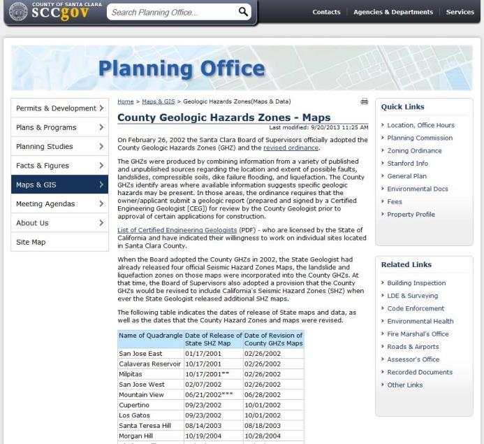
12 Santa Clara County Geologic Hazards Zones Maps

13 Santa Clara County - Index Map

14 Santa Clara County Example Map Sheet

15 Setbacks - North Salt Lake City, UT Adopts IBC 2013 without change Setbacks specified as function of slope height Separate requirement for slopes >1:1 Alternate setbacks and clearances are permitted, subject to the approval of the building official. The building official shall be permitted to require a geotechnical investigation
16 Setback North Salt Lake City
17 Setbacks Salt Lake City, UT : LAND DEVELOPMENT REQUIREMENTS (BUILDING SITES) C. Soil Engineering Report Or Engineering Geology Required: 1. Soil Engineering Report: The soil engineering report required shall include data regarding the nature, distribution, and strength of existing soils, conclusions and recommendations for grading procedures, design criteria for corrective measures when necessary, and opinions and recommendations addressing the adequacy of the site under the proposed grading plan to support the proposed development. 2. Engineering Geology Report: The engineering geology report required shall include an adequate description of the geology of the site, conclusions and recommendations regarding the effect of geologic conditions on the proposed development, and opinions and recommendations addressing the adequacy of the site under the proposed grading plan to support the proposed development. This requirement may be waived by written recommendation of the building official if it is deemed unwarranted.
18 Setbacks Salt Lake City, UT H a b1 Less than 5' 0 1 5' to 30' H/2 H/5 Over 30' 15 6 a = Setback distance at toe in feet b = Setback at top in feet H = Height from toe to top of cut/fill slope PA = Permit Area (Lot Area Excluding Any Undevelopable Area) H a b1 Less 0 1 than 5' 5' to 30' H/2 H/5 Over 30' 15 6
19 Setbacks - Salt Lake City 3. Undevelopable Slopes: Any natural slopes identified on a slope classification map of thirty percent (30%) or greater shall be designated undevelopable area. In no event shall streets traverse such slopes. 4. e. Exceptions: (to cut and fill slopes) (1) No slopes shall cut steeper than the bedding plane, fracture, fault, or joint in any formation where the cut slope will lie on the dip of the strike line of the bedding plane, fracture, fault, or joint. (2) No slopes shall be cut in an existing landslide, mudflow, or other form of naturally unstable slope except as recommended by a qualified geological engineer. (3) Where the formation is exposed above the top of the cut which will permit the entry of water along bedding planes, this area shall be sealed with a compacted soil blanket having a minimum thickness of two feet (2'). The soil for this blanket shall be relatively impervious and shall be approved by the soils engineer or engineering geologist. I. Setbacks: The setback and other restrictions specified in this section are minimum and may be increased by the building official or by the recommendation of a civil engineer, soils engineer, or engineering geologist, if necessary for safety and stability
20 Setbacks Bainbridge Island, WA City of Bainbridge Island, Geologically hazardous areas. B. Purpose. The intent of this section is to prevent the potential for personal injury or loss of life or property due to flooding, erosion, landslides, seismic events, or soil subsidence. Development must not increase slope instability, and must avoid on-site and off-site impacts, as well as potential risk to structures. Preserving the existing vegetation may be an important part of minimizing those risks. C. Classification. Geologically hazardous areas shall be classified based upon landslide history and the presence of unstable soils, steepness of slopes, erosion potential, and seismic hazards. Areas in this category are a potential threat to public health, safety, and welfare when construction is allowed. While some potential risk due to construction can be reduced through structural engineering design, construction in these areas should be avoided when the potential risk cannot be reduced to a level comparable to the risk if the site were initially stable prior to construction. Classification and rating shall be based upon the risk to the environment and to development in geologically hazardous areas.
21 Setbacks Bainbridge Island, WA D. Minimum Submittal Requirements. 1. All Geologically Hazardous Areas and Buffers. a. Indemnification. An indemnification or hold harmless agreement shall be required for all projects in geologically hazardous areas and buffers except erosion hazard areas and tsunami hazard areas. The form of the agreement shall be approved by the city and executed prior to the commencement of construction or site alteration. 2. Development Design and Location. The following requirements shall apply to any land or vegetation modification or construction within a landslide hazard area and/or its buffer as described herein: a. Buffer Requirement. A buffer equal to the height of the slope or 50 feet, whichever is greater, shall be established from all edges of a landslide hazard area except where no other reasonable alternative exists, reduction may be allowed as follows:
22 Public Outreach City of Seattle City of Seattle and Santa Clara County have websites with additional general information on landslides and geologic hazards for the public City of Seattle Good Example of Public Meeting Technical Information Aimed at General Public Do s and Dont s of Slope Development/Maintenance Following Slides Courtesy of Bill Laprade of Shannon & Wilson

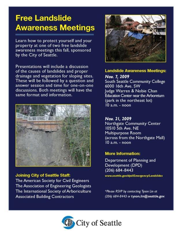
23 Public Notice
24 City of Seattle Public Landslide Meetings INTRODUCTION LANDSLIDES IN SEATTLE The Geology, Types Of Landslides VEGETATION ON SLOPES CITY LANDSLIDE MITIGATION PROGRAM CITY LANDSLIDE POLICY AND ENVIRONMENTALLY CRITICAL AREAS REGULATIONS (ECA) MANAGEMENT TOOLS FOR HOMEOWNERS QUESTIONS AND ANSWERS ONE-ON-ONE Questions And Answers With City & Private Sector Experts
25 City of Seattle Public Landslide Meetings INTRODUCTION Alan Justad, Community Relations Department of Planning and Development (DPD) LANDSLIDES IN SEATTLE THE GEOLOGY, TYPES OF LANDSLIDES Bill Laprade, Engineering Geologist and VP Shannon & Wilson VEGETATION ON SLOPES Mark Mead, Urban Forester Seattle Parks and Recreation CITY LANDSLIDE MITIGATION PROGRAM Bill Benzer, Senior Geotechnical Engineer Keith Ward, Senior Geotechnical Engineer Seattle Public Utilities CITY LANDSLIDE POLICY AND ENVIRONMENTALLY CRITICAL AREAS REGULATIONS (ECA) Alan Justad, DPD MANAGEMENT TOOLS FOR HOMEOWNERS Bill Laprade, Shannon & Wilson QUESTIONS AND ANSWERS ONE-ON-ONE QUESTIONS AND ANSWERS WITH CITY & PRIVATE SECTOR EXPERTS

26 City Experts Seattle Public Utilities Seattle Parks and Recreation Seattle Department of Transportation Seattle Department of Planning and Development
27 Outside Experts American Society of Civil Engineers (Geotechnical Group) Association of Environmental & Engineering Geologists ABC Construction International Society of Arboriculture
28 Development Regulations for Landslide-Prone Property in Seattle Environmental Critical Areas Ordinance Stormwater, Grading and Drainage Ordinance Professional Assessment Permit/Inspections
29 Environmentally Critical Areas: Geologic Hazard Areas in Seattle Known landslide areas Potential landslide areas (over 15% slope with certain soils) Steep slopes (40% or greater average slope) Liquefaction-prone

30 Don t List Don t put fill on steep slope. Don t concentrate water on slope if you don t have anything better. Don t denude vegetation on slope without revegetation plan. Don t put fill on slopes, especially top. Don t cut into toe of slope. Don t remove tree stumps. Don t place yard debris on slopes. Don t walk away from it. Don t install permanent irrigation system in LPAs.
31 Do List Maintain drainage. Perform periodic inspections of property (before and during storms). Check weep holes on walls. Do be alert during and following storms. If you have an irrigation system, shut it off and check it out seasonally. Keep fill and yard waste off slopes. Leave stumps in the ground.

32 California Susceptibility Map and Loss Simulation - CDMG State Landslide Deep-seated Landslide inventory map as a basis Use rock strengths based on rock type and combine with slope steepness Generate landslide susceptibility map using HAZUS methodology Use estimates of direct private property loss and Caltrans infrastructure loss data from several historical storms Estimate loss ratios Simulate losses from future storm scenario using ARkStorm Source: Wills et al, 2014 ASCE Natural Hazards Review
33
CHAPTER GEOLOGICALLY HAZARDOUS AREAS Applicability Regulations.
 CHAPTER 19.07 GEOLOGICALLY HAZARDOUS AREAS 19.07.010 Applicability. Geologically hazardous areas may pose a threat to the health and safety of citizens when incompatible development is sited in areas of
COMMUNITY DEVELOPMENT DEPARTMENT POLICY & PROCEDURE
 COMMUNITY DEVELOPMENT DEPARTMENT POLICY & PROCEDURE Policy No: DSP-OO3 Release Date: January 1, 2014 Effective Date: January 1, 2014 Revision Date: March 1, 2018 TITLE: The City Policy for Site Specific
SLOPE STABILITY EVALUATION AND ACCEPTANCE STANDARDS
 INFORMATION BULLETIN / PUBLIC - BUILDING CODE REFERENCE NO.: LABC 7006.3, 7014.1 Effective: 01-01-2017 DOCUMENT NO.: P/BC 2017-049 Revised: 12-21-2016 Previously Issued As: P/BC 2014-049 SLOPE STABILITY
SLOPE STABILITY EVALUATION AND ACCEPTANCE STANDARDS
 INFORMATION BULLETIN / PUBLIC - BUILDING CODE REFERENCE NO.: LAMC 98.0508 Effective: 1-26-84 DOCUMENT NO. P/BC 2002-049 Revised: 11-1-02 Previously Issued As: RGA #1-84 SLOPE STABILITY EVALUATION AND ACCEPTANCE
9. GEOLOGY, SOILS, AND MINERALS
 June 28, 2018 Page 9-1 9. GEOLOGY, SOILS, AND MINERALS This EIR chapter describes the existing geological, soil, and mineral conditions in the planning area. The chapter includes the regulatory framework
GOAL 7 AREAS SUBJECT TO NATURAL DISASTERS AND HAZARDS. To protect life and property from natural disasters and hazards.
 GOAL 7 AREAS SUBJECT TO NATURAL DISASTERS AND HAZARDS A. GOALS: To protect life and property from natural disasters and hazards. B. POLICIES: 1. Floodplains shall be maintained as natural drainage-ways.
COMMUNITY DEVELOPMENT DEPARTMENT POLICY & PROCEDURE
 COMMUNITY DEVELOPMENT DEPARTMENT POLICY & PROCEDURE Policy No: DSP-OO3 Release Date: January 1, 2014 Effective Date: January 1, 2014 Revision Date: March 1, 2018 TITLE: The City Policy for Site Specific
COMMUNITY DEVELOPMENT DEPARTMENT POLICY & PROCEDURE
 COMMUNITY DEVELOPMENT DEPARTMENT POLICY & PROCEDURE Policy No: DSP-OO3 Release Date: January 1, 2014 Effective Date: January 1, 2014 Revision Date: July 1, 2018 TITLE: The City Policy for Site-Specific
 265 Dalewood Way alteration permit #2016/02/17/9761 June 30, 2016 Appeal #16-109 Deck at Rear due to conflict with Slope Protection Act A. Executive Summary: We are in receipt of the Notification of Structural
County of Santa Cruz
 County of Santa Cruz BOARD OF SUPERVISORS 701 OCEAN STREET, SUITE 500, SANTA CRUZ, CA 95060-4069 (831) 454-2200 FAX: (831) 454-3262 TDD: (831) 454-2123 JANET K. BEAUT2 ELLEN PlRlE NEAL COONERTY TONY CAMPOS
LANDUSE APPLICATIONS OF EARTHQUAKE HAZARD MAPS CALIFORNIA EXPERIENCE
 LANDUSE APPLICATIONS OF EARTHQUAKE HAZARD MAPS CALIFORNIA EXPERIENCE Thomas C. Vlasic Vice President Spangle Associates Portola Valley, California INTRODUCTION The focus of this report is primarily on
Guidelines for Site-Specific Seismic Hazard Reports for Essential and Hazardous Facilities and Major and Special-Occupancy Structures in Oregon
 Guidelines for Site-Specific Seismic Hazard Reports for Essential and Hazardous Facilities and Major and Special-Occupancy Structures in Oregon By the Oregon Board of Geologist Examiners and the Oregon
4.5 GEOLOGY AND SOILS
 4.5 GEOLOGY AND SOILS This section addresses the project site geology and soils and analyzes potential changes that would result from development of the Wye Specific Plan project. 4.5.1 Environmental Setting
Pierce County Department of Planning and Land Services Development Engineering Section
 Page 1 of 7 Pierce County Department of Planning and Land Services Development Engineering Section PROJECT NAME: DATE: APPLICATION NO.: PCDE NO.: LANDSLIDE HAZARD AREA (LHA) GEOLOGICAL ASSESSMENT REPORT
MEMORANDUM. REVISED Options for Landslide Regulations: Setbacks and Slope Height
 Snohomish County Council Office MS #609 3000 Rockefeller Avenue Everett, WA 98201 (425) 388-3494 MEMORANDUM DATE: May 2, 2014 TO: FROM: RE: Councilmembers Will Hall, Council Staff REVISED Options for Landslide
Downtown Anchorage Seismic Risk Assessment & Land Use Regulations to Mitigate Seismic Risk
 Prepared for: The Municipality of Anchorage Planning Department and the Geotechnical Advisory Commission Downtown Anchorage Seismic Risk Assessment & Land Use Regulations to Mitigate Seismic Risk Prepared
Geologic Hazards and Whatcom County Code. Andy Wiser, L.E.G , ext 50274
 Geologic Hazards and Whatcom County Code Andy Wiser, L.E.G. awiser@whatcomcounty.us 360.676.6907, ext 50274 Chapter 16.16, Article 3 Geologically Hazardous Areas 16.16.300 Purpose: 1. Minimize Risk: Minimize
ENGINEERING EVALUATION OF THE STANLEY MINE ADVENTURE PARK AREA CLEAR CREEK COUNTY, COLORADO. Prepared for:
 braun Braun Consulting Engineers ENGINEERING EVALUATION OF THE STANLEY MINE ADVENTURE PARK AREA CLEAR CREEK COUNTY, COLORADO Prepared for: STANLEY MINES ADENTURE PARK 3375 W. POWERS CIRCLE LITTLETON, COLORADO
4.5 GEOLOGY AND SOILS
 4.5.1 Setting 4.5 GEOLOGY AND SOILS a. Regional Geology. The is located in the south central Santa Cruz Mountains in the heart of the Central Coast ranges of California. This is a seismically active region
Roadmap to Stability
 Landslide Policy Committee for Aizawl City February 2014 Technical Support by: Aizawl is in earthquake hazard zone V and highly prone to natural, man-made and earthquake induced landslides. In order to
Implementation of the Alquist-Priolo Earthquake Fault Zoning Act in Los Angeles County
 Implementation of the Alquist-Priolo Earthquake Fault Zoning Act in Los Angeles County Charles Nestle County of Los Angeles Dept. of Public Works Surface Fault Rupture Workshop May 10, 2013 What Work is
Interpretive Map Series 24
 Oregon Department of Geology and Mineral Industries Interpretive Map Series 24 Geologic Hazards, and Hazard Maps, and Future Damage Estimates for Six Counties in the Mid/Southern Willamette Valley Including
APPLICATIONS OF EARTHQUAKE HAZARD MAPS TO LAND-USE AND EMERGENCY PLANNING EXAMPLES FROM THE PORTLAND AREA
 APPLICATIONS OF EARTHQUAKE HAZARD MAPS TO LAND-USE AND EMERGENCY PLANNING EXAMPLES FROM THE PORTLAND AREA O. Gerald Uba Metro, Portland, Oregon OVERVIEW The extent to which we understand "below ground"
Seismic Geotechnical Hazard Zonation Of Geological Factors
 1 st Workshop of M.E.E.T.I.N.G Project Seismic Geotechnical Hazard Zonation Of Geological Factors Maja Oštri, dipl.ing.geol Dubrovnik, March 3rd-4th 2008 SUBJECT OF THE INVESTIGATION? Geological Factors
9/13/2011 CHAPTER 9 AND SUBSIDENCE. Case History: La Conchita Landslide. Introduction
 CHAPTER 9 SLOPE PROCESSES, LANDSLIDES, AND SUBSIDENCE Case History: La Conchita Landslide La Conchita: small coastal community 80 km (50 mi) northwest of Los Angeles Landslide occurred on January 10, 2005
Report to the Seventy-first Legislative Assembly on the Implementation of 1999 Senate Bill 12 Relating to Public Safety and Rapidly Moving Landslides
 Report to the Seventy-first Legislative Assembly on the Implementation of 1999 Senate Bill 12 Relating to Public Safety and Rapidly Moving Landslides December 28, 2000 Department of Geology and Mineral
SANTA BARBARA COUNTY ZONING ADMINISTRATOR Coastal Zone Staff Report
 SANTA BARBARA COUNTY ZONING ADMINISTRATOR Coastal Zone Staff Report Deputy Director: Alice McCurdy Staff Report Date: October 31, 2014 Division: Development Review Case No.: 10CDH-00000-00027 Supervising
IV. ENVIRONMENTAL IMPACT ANALYSIS E. GEOLOGY/SOILS
 IV. ENVIRONMENTAL IMPACT ANALYSIS E. GEOLOGY/SOILS The following discussion is based upon information contained in the Hollywood Redevelopment Plan Amendment EIR and a letter prepared by Geotechnologies,
City of Manitou Springs
 March 2018 City of Manitou Springs Implementing Land Use tools to reduce and mitigate natural hazard risk Context & History Past Present Historic homes Older infrastructure Hillside development Creekside
Chapter 7 Mudflow Analysis
 Chapter 7 Mudflow Analysis 7.0 Introduction This chapter provides information on the potential and magnitude of mud floods and mudflows that may develop in Aspen due to rainfall events, snowmelt, or rain
IV. ENVIRONMENTAL IMPACT ANALYSIS G. GEOLOGY AND SOILS
 IV. ENVIRONMENTAL IMPACT ANALYSIS G. GEOLOGY AND SOILS The following section is a summary of the geotechnical report conducted for the proposed project. The Report of Geotechnical Investigation Proposed
TODAY - March 20, 2000
 information subject to this section and Sections 40(1) and 40(2) of DAO 92-29, shall be done only in cases allowed under Section 40(3) SECTION 9. FINES AND PENALTIES. Any person, natural or juridical,
Need of Proper Development in Hilly Urban Areas to Avoid
 Need of Proper Development in Hilly Urban Areas to Avoid Landslide Hazard Dr. Arvind Phukan, P.E. Cosultant/Former Professor of Civil Engineering University of Alaska, Anchorage, USA RI District Governor
Template for Sediment and Erosion Control Plan General Instructions. Section Instructions
 Template for Sediment and Erosion Control Plan General Instructions Introduction: Soil erosion and sediment deposition from farmlands can contribute to degraded surface water quality. Sediment delivery
Landslide Mitigation (BYUI)
") Landslide Mitigation (BYUI) The general principle behind landslide mitigation is stabilization. Slopes that are too steep are shallowed or strengthened. Loose rocks can be bolted or cemented into place.
Landslide Mitigation (BYUI) The general principle behind landslide mitigation is stabilization. Slopes that are too steep are shallowed or strengthened. Loose rocks can be bolted or cemented into place.
Woodford County Erosion Prevention Plan and Permit. Application #
 Woodford County Erosion Prevention Plan and Permit Application # Date Instructions: Applicant will complete Parts A and B, and attach a proposed site diagram. This diagram must be completed in accordance
Chapter 7 Mudflow Analysis
 Chapter 7 Mudflow Analysis 7.0 Introduction This chapter provides information on the potential and magnitude of mud floods and mudflows that may develop in Aspen due to rainfall events, snowmelt, or rain
GEOLOGY AND SOILS. This chapter summarizes geologic and geotechnical aspects of the site as they relate to the Project.
 9 GEOLOGY AND SOILS INTRODUCTION This chapter summarizes geologic and geotechnical aspects of the site as they relate to the Project. This chapter utilizes information from the following reports prepared
3.8 Geology/Soils. Environmental Setting. Topography. Geology and Soils
 3.8 Geology/Soils This section examines whether implementation of the 2004 Land Use Mobility Elements, Zoning Code Revisions, and Central District Specific Plan the will expose people or structures to
They include earthquakes, volcanic eruptions, floods, landslides, and other processes and occurrences. They are included in the broader concept of.
 They include earthquakes, volcanic eruptions, floods, landslides, and other processes and occurrences. They are included in the broader concept of. In general, natural processes are labeled hazardous only
Chronic Coastal Natural Hazards Model Overlay Zone
 DLCD SECTION 309 COASTAL NATURAL HAZARDS STRATEGY Oceanfront Construction Setbacks Project: Chronic Coastal Natural Hazards Model Overlay Zone Section 0-0.010 PURPOSE The purpose of this ordinance is to:!
Roy Pyle March 24, 2017 Chief Facilities Planner Contra Costa Community College District 500 North Court Street Martinez, CA 94533
 State of California Natural Resources Agency Edmund G. Brown Jr., Governor Department of Conservation John G. Parrish, Ph.D., State Geologist California Geological Survey 801 K Street MS 12-31 Sacramento,
Geology, Soils, and Seismicity
 Section 3.8 Geology, Soils, and Seismicity Introduction This section generally evaluates the effects of the alternatives analyzed in this Supplemental DEIS with regard to geology, soils and seismicity.
Multi-Jurisdictional Hazard Mitigation Plan. Table C.10 The Richter Scale. Descriptor Richter Magnitude Earthquake Effects
 Geologic Hazards Earthquake Earthquakes are very rare in Pennsylvania and have caused little damage, with no reported injuries or causalities. Earthquakes that do occur in Pennsylvania happen deep within
IV. ENVIRONMENTAL IMPACT ANALYSIS E. GEOLOGY AND SOILS
 IV. ENVIRONMENTAL IMPACT ANALYSIS E. GEOLOGY AND SOILS The following section is a summary of the geotechnical report conducted for the Proposed Project. The Geotechnical Engineering Investigation (the
IV. ENVIRONMENTAL IMPACT ANALYSIS E. GEOLOGY/SEISMIC HAZARDS
 IV. ENVIRONMENTAL IMPACT ANALYSIS E. GEOLOGY/SEISMIC HAZARDS 1. ENVIRONMENTAL SETTING The following analysis of geology and seismic hazards for the Middle School Project is based on the Report of Geotechnical
Oregon APA Legal Issues Workshop December 7, Tricia Sears, DLCD With information from Bill Burns, DOGAMI
 Oregon APA Legal Issues Workshop December 7, 2018 Tricia Sears, DLCD With information from Bill Burns, DOGAMI How this Topic Arrived WE FREQUENTLY HEAR CONCERNS ABOUT LIABILITY AND TAKINGS. Current federal
ENGINEER S CERTIFICATION OF FAULT AREA DEMONSTRATION (40 CFR )
") PLATTE RIVER POWER AUTHORITY RAWHIDE ENERGY STATION BOTTOM ASH TRANSFER (BAT) IMPOUNDMENTS LARIMER COUNTY, CO ENGINEER S CERTIFICATION OF FAULT AREA DEMONSTRATION (40 CFR 257.62) FOR COAL COMBUSTION RESIDUALS
PLATTE RIVER POWER AUTHORITY RAWHIDE ENERGY STATION BOTTOM ASH TRANSFER (BAT) IMPOUNDMENTS LARIMER COUNTY, CO ENGINEER S CERTIFICATION OF FAULT AREA DEMONSTRATION (40 CFR 257.62) FOR COAL COMBUSTION RESIDUALS
Page G Crow Wing County Multi-Hazard Mitigation Plan, 2017
 Table G - 10. s Identified by the () (From Crow Wing County Master Chart) 1 5 All- Hazards All- Hazards Work to ensure that all Crow Wing County residents are aware of and sign-up for the County s Emergency
COASTAL HAZARDS. Alan Lulloff, Water Management Engineer Wisconsin Department of Natural Resources. Local Contact: John Spangberg (715)
") COASTAL HAZARDS Alan Lulloff, Water Management Engineer Wisconsin Department of Natural Resources Local Contact: John Spangberg (715)685-2923 The Northwest Ordinance of 1787 and the river Mississippi and
COASTAL HAZARDS Alan Lulloff, Water Management Engineer Wisconsin Department of Natural Resources Local Contact: John Spangberg (715)685-2923 The Northwest Ordinance of 1787 and the river Mississippi and
4.5 GEOLOGY, SOILS AND SEISMICITY
 4.5 This section summarizes information on geology, soils and seismic hazards, and mineral resources in the Truckee area, as well as potential area-wide geologic hazards and regional seismic characteristics
DEPARTMENT OF GEOLOGY AND MINERAL INDUSTRIES WAYS & MEANS SUBCOMMITTEE ON NATURAL RESOURCES MARCH 2, 2017
 DEPARTMENT OF GEOLOGY AND MINERAL INDUSTRIES WAYS & MEANS SUBCOMMITTEE ON NATURAL RESOURCES MARCH 2, 2017 1 ABOUT DOGAMI AGENCY MISSION, VISION & GOALS 2 Lidar image of a stream network along the Umpqua
GUIDELINES FOR FILMING IN TOMBALL, TEXAS
 GUIDELINES FOR FILMING IN TOMBALL, TEXAS I. PURPOSE The following guidelines are intended to protect the personal and property rights of our Tomball, Texas residents and businesses. The City Manager reserves
Brea Olinda Unified School District
 Brea Olinda Unified School District Updated May 2, 2011 Olinda School Frequently Asked Questions 1. Will the new school will be breaking ground this Fall? YES! BOUSD held the Groundbreaking Ceremony on
3E. Geology and Soils
 INTRODUCTION The purpose of this chapter is to evaluate the proposed project s impacts on local geological features and whether it would expose people or structures to adverse geological impacts. Potential
GEOL 314 Engineering Geology
 GEOL 314 Engineering Geology Dr. Robert Mitchell ES234 Winter 2013 650-3591 robert.mitchell@wwu.edu http://kula.geol.wwu.edu/rjmitch/ Office Hours: MWF 2-3:00 pm or by arrangement Text: Geotechnical Engineering
5.11 Geology and Soils
 5.11 Geology and Soils 5.11 GEOLOGY AND SOILS This section evaluates the geologic and seismic conditions within the City of Azusa and evaluates the potential for geologic hazard impacts associated with
Baldwin County, Alabama
 2015 Baldwin County, Alabama Multi-Hazard Mitigation Plan I. Comprehensive Plan A multi-jurisdiction plan City of Bay Minette City of Daphne Town of Elberta City of Fairhope City of Foley City of Gulf
9/23/2013. Introduction CHAPTER 7 SLOPE PROCESSES, LANDSLIDES, AND SUBSIDENCE. Case History: La Conchita Landslide
 Introduction CHAPTER 7 SLOPE PROCESSES, LANDSLIDES, AND SUBSIDENCE Landslide and other ground failures posting substantial damage and loss of life In U.S., average 25 50 deaths; damage more than $3.5 billion
PHIMF Project - Limited Geotechnical Investigation - Feasibility-Level Report RESPONSE TO INITIAL REVIEW LETTER
 Connie Christian, P.E. County Sanitation Districts of Los Angeles County 1955 Workman Mill Road Whittier, California 90601 Project No. BAS 04-02E January 29, 2008 Subject: PHIMF Project - Limited Geotechnical
SLOPE PROCESSES, LANDSLIDES, AND SUBSIDENCE
 CHAPTER 9 SLOPE PROCESSES, LANDSLIDES, AND SUBSIDENCE La Conchita slide January 10, 2005 Triggered by heavy rainfall, reactivation along an older landslide surface (35,000 years ago, 6000 years ago, and
IV. ENVIRONMENTAL IMPACT ANALYSIS G. GEOLOGY AND SOILS
 IV. ENVIRONMENTAL IMPACT ANALYSIS G. GEOLOGY AND SOILS INTRODUCTION The information and analysis in this section is based primarily on the following report, which is included in Appendix IV.G of this EIR:
BUILDING AND SAFETY FEE SCHEDULE (Effective July1, 2013)
") BUILDING AND SAFETY DIVISION TELEPHONE (949) 724-6300 BUILDING AND SAFETY FEE SCHEDULE (Effective July1, 2013) Payment: When a plan is required by the Administrative Authority to be submitted, a plan check
BUILDING AND SAFETY DIVISION TELEPHONE (949) 724-6300 BUILDING AND SAFETY FEE SCHEDULE (Effective July1, 2013) Payment: When a plan is required by the Administrative Authority to be submitted, a plan check
Landslide & Coastal Erosion Risk Reduction at Oregon s Water/Wastewater Networks
 Landslide & Coastal Erosion Risk Reduction at Oregon s Water/Wastewater Networks Laura Gabel, RG (with Bill Burns, RG & Jonathan Allan, Ph. D) Oregon Department of Geology and Mineral Industries (541)
4.9 GEOLOGY AND SOILS
 4.9 GEOLOGY AND SOILS 4.9.1 EXISTING CONDITIONS TOPOGRAPHY AND RELIEF Zone 40 is located in the central portion of Sacramento County. The topography of the county is represented by three physiographic
2. Initial Summary of Preliminary Expert Opinion of Converse and Psomas Reports
 UNITED WALNUT TAXPAYERS PRELIMINARY REVIEW OF NEGATIVE GEOTECHNICAL AND GEOLOGICAL ASPECTS OF CONSTRUCTING EARTHFILL PAD FOR A SOLAR FARM ON THE WEST PARCEL - DRAFT 1. Introduction A licensed Engineering
Mass Wasting. Revisit: Erosion, Transportation, and Deposition
 Mass Wasting Revisit: Erosion, Transportation, and Deposition While landslides are a normal part of erosion and surface processes, they can be very destructive to life and property! - Mass wasting: downslope
EXHIBIT H LOT 317 GRADING AND SITE PLAN
 EXHIBIT H LOT 317 GRADING AND SITE PLAN EXHIBIT I LOT 317 ELEVATIONS ridge height 4915'-6" GENERAL & KEYED NOTES ridge height 4905'-9" 3 7 4 A5.1 1 5 ridge height 4910'-6" 2 ridge height 4906'-3" 1 Provide
Converse Consultants Geotechnical Engineering, Environmental & Groundwater Science, Inspection & Testing Services
 Converse Consultants Geotechnical Engineering, Environmental & Groundwater Science, Inspection & Testing Services Ms. Rebecca Mitchell Mt. San Antonio College Facilities Planning & Management 1100 North
Appendix K.2: Sediment Management Excerpt from South Orange County Hydromodification Management Plan
 Appendix K.2: Sediment Management Excerpt from South Orange County Hydromodification Management Plan 4 Sediment Supply Management Requirements Permit Order R9-2013-0001 as amended by Order No. R9-2015-0001Section
4.5 Geology and Soils
 4.5 Geology and Soils This section evaluates potential geology and soils impacts that could affect or result from the future development consistent with the Encinitas Housing Element Update (HEU). Information
Lyttelton Port Company Limited Submitter 915 / FS Statement of evidence of Neil James Charters
 Before the Independent Hearings Panel at Christchurch under: in the matter of: and: the Resource Management Act 1991 and the Canterbury Earthquake (Christchurch Replacement District Plan) Order 2014 submissions
DRAFT. PRELIMINARY LANDSLIDE MODELING for KRAMER AVENUE LANDSLIDE SITKA, ALASKA. Prepared for: Andrew Friske 210 Kramer Ave. Sitka, Alaska 99835
 PRELIMINARY LANDSLIDE MODELING for KRAMER AVENUE LANDSLIDE SITKA, ALASKA Prepared for: Andrew Friske 210 Kramer Ave. Sitka, Alaska 99835 Prepared by: Northern Geotechnical Engineering, Inc. d.b.a. Terra
Protecting the Storm Damage Prevention and Flood Control Interests of Coastal Resource Areas
 Protecting the Storm Damage Prevention and Flood Control Interests of Coastal Resource Areas Presented by: Massachusetts Department of Environmental Protection & Massachusetts Office of Coastal Zone Management
REQUEST FOR PROPOSALS CLOSING DATE:
 Request for Proposals 110 Westlake Drive City of West Lake Hills 110 Westlake Drive REQUEST FOR PROPOSALS CLOSING DATE: Tuesday, October 23, 2018 City of West Lake Hills Request for Proposals 1 I. INTRODUCTION
Slope Stability Evaluation Ground Anchor Construction Area White Point Landslide San Pedro District Los Angeles, California.
 Slope Stability Evaluation Ground Anchor Construction Area White Point Landslide San Pedro District Los Angeles, California Submitted To: Mr. Gene Edwards City of Los Angeles Department of Public Works
Programmatic Approaches to Assessing and Mitigating Risk to Pipelines from Natural Forces
 Programmatic Approaches to Assessing and Mitigating Risk to Pipelines from Natural Forces 23 rd International Petroleum Environmental Conference New Orleans, Louisiana November 8-10, 2016 Introduction
3l NATURAL HAZARDS AND UNSTABLE GROUND
 Page 1 of Section 3l 3l NATURAL HAZARDS AND UNSTABLE GROUND 3l.1 Introduction A natural hazard is the result of natural processes that form, shape and change the environment and interact or potentially
Timeframe. Crow Wing County, Baxter, Brainerd, Breezy Point, Crosby, Crosslake, Cuyuna, Deerwood, Emily, Fifty
 Table G - 13. s Identified for by the () (From Crow Wing County Master Chart) 1 5 9 All- Hazards All- Hazards Winter Work to ensure that all Crow Wing County residents are aware of and sign-up for the
Date: April 2, 2014 Project No.: Prepared For: Mr. Adam Kates CLASSIC COMMUNITIES 1068 E. Meadow Circle Palo Alto, California 94303
 City of Newark - 36120 Ruschin Drive Project Draft Initial Study/Mitigated Negative Declaration Appendix C: Geologic Information FirstCarbon Solutions H:\Client (PN-JN)\4554\45540001\ISMND\45540001 36120
AUTHORIZE THE TOWN MANAGER TO EXECUTE AN AGREEMENT GEOLOGY AND GEOTECHNICAL ENGINEERING CONSULTANT
 pwn MEETING DATE: 06/18/ 12 1 t COUNCIL AGENDA REPORT ITEM NO: i DATE: JUNE 7, 2012 TO: FROM: MAYOR AND TOWN COUNCIL GREG LARSON, TOWN MANAGER W" SUBJECT: PPW JOB NO. Al2-003 - GEOLOGY AND GEOTECHNICAL
HOUSE BILL No June 19, 2007, Introduced by Reps. Warren, Ward, Gillard, Wojno and Bauer and referred to the Committee on Regulatory Reform.
 HOUSE BILL No. 4947 HOUSE BILL No. 4947 June 19, 2007, Introduced by Reps. Warren, Ward, Gillard, Wojno and Bauer and referred to the Committee on Regulatory Reform. A bill to amend 1980 PA 299, entitled
4.5 GEOLOGY AND SOILS
 4.5 GEOLOGY AND SOILS This section discusses the proposed project s potential impacts relating to geologic hazards. This section is partially based on the Preliminary Soil Engineering and Geologic Hazards
FOR PROJECTS INITIATED AFTER NOVEMBER 1, 2008 ITEM 716 EMBANKMENT EARTH OUTLET SEDIMENT TRAP
 AFTER NOVEMBER 1, 2008 ITEM 716 EMBANKMENT EARTH OUTLET SEDIMENT TRAP 716.1 Description. This work shall consist of furnishing, installing, maintaining, and removing temporary erosion protection and sediment
IV. ENVIRONMENTAL IMPACT ANALYSIS E. GEOLOGY AND SOILS
 IV. ENVIRONMENTAL IMPACT ANALYSIS E. GEOLOGY AND SOILS The following analysis is based on the Geotechnical Investigation Report, Proposed Mid-Rise Multi- Family Residential Development Project Wetherly
Template for Sediment and Erosion Control Plan General Instructions
 Template for Sediment and Erosion Control Plan General Instructions Introduction: Soil erosion and sediment deposition from farmlands can contribute to degraded surface water quality. Sediment delivery
Impact : Changes to Existing Topography (Less than Significant)
") 4.2 Land Resources 4.2.1 Alternative A Proposed Action Impact 4.2.1-1: Changes to Existing Topography (Less than Significant) Development of the project site would involve grading and other earthwork as
4.2 Land Resources 4.2.1 Alternative A Proposed Action Impact 4.2.1-1: Changes to Existing Topography (Less than Significant) Development of the project site would involve grading and other earthwork as
Application #: TEXT
 TOWN OF FORT MYERS BEACH 2008 PROPOSED COMPREHENSIVE PLAN AMENDMENTS Application #: 2008-13-TEXT Description: Modify the Coastal Management and Future Land Use Elements to reflect the state s new definition
SECTION DESCRIPTION PAGE I. BUDGET INTRODUCTION... 1 II. FISCAL YEAR 2017 BUDGET ANALYSIS... 2 III. FINAL OPERATING BUDGET... 3
 2018 SECTION DESCRIPTION PAGE I. BUDGET INTRODUCTION... 1 II. FISCAL YEAR 2017 BUDGET ANALYSIS... 2 III. FINAL OPERATING BUDGET... 3 IV. GENERAL FUND 001 DESCRIPTIONS... 4 Background Information The Four
Response on Interactive comment by Anonymous Referee #1
 Response on Interactive comment by Anonymous Referee #1 Sajid Ali First, we would like to thank you for evaluation and highlighting the deficiencies in the manuscript. It is indeed valuable addition and
SCHUSTER SLOPE LANDSCAPE MANAGEMENT PLAN. January 15, 2015
 SCHUSTER SLOPE LANDSCAPE MANAGEMENT PLAN January 15, 2015 1 WHY DO WE NEED A LANDSCAPE MANAGEMENT PLAN? 2 PROCESS FOR DEVELOPING THE SCHUSTER SLOPE LANDSCAPE MANAGEMENT PLAN 3 NORTH DOWNTOWN SUB AREA PLAN
MESOZOIC BASINS. North Carolina Geological Survey
 MESOZOIC BASINS North Carolina Geological Survey The 1823 organic act which created the North Carolina Geological Survey (NCGS) tasked us to examine, describe and map the geology, geologic hazards, and
Association of Environmental & Engineering Geologists (AEG) To join AEG: Student membership is Free! Ask about our scholarships.
 To join AEG: Student membership is Free! Ask about our scholarships.") Association of Environmental & Engineering Geologists (AEG) To join AEG: www.aegweb.org/join Student membership is Free! Ask about our scholarships. What is the Association of Environmental & Engineering
Association of Environmental & Engineering Geologists (AEG) To join AEG: www.aegweb.org/join Student membership is Free! Ask about our scholarships. What is the Association of Environmental & Engineering
5.5 Geology, Soils and Seismicity
 5.5 Geology, Soils and Seismicity 5.5.1 Introduction Information and recommendations presented in this section were taken from the original East Lake Specific Plan Environmental Impact Report (EIR) [State
APPLICATION TO AMEND THE FUTURE LAND USE MAP (FLUM) SMALL SCALE
 SMALL SCALE") DEPARTMENT OF DEVELOPMENT & PLANNING 825 Ohio Avenue - Lynn Haven, FL 32444 (850) 265-2961 - (850) 265-3478 APPLICATION TO AMEND THE FUTURE LAND USE MAP (FLUM) SMALL SCALE Deadline to submit is 30 days
DEPARTMENT OF DEVELOPMENT & PLANNING 825 Ohio Avenue - Lynn Haven, FL 32444 (850) 265-2961 - (850) 265-3478 APPLICATION TO AMEND THE FUTURE LAND USE MAP (FLUM) SMALL SCALE Deadline to submit is 30 days
Shasta Valley Groundwater Basin Boundary Modification
 Shasta Valley Groundwater Basin Boundary Modification Sustainable Groundwater Management Act (SGMA) September 2014 Governor Brown signs legislation requiring groundwater resources be managed by local agencies
Appendix E Guidance for Shallow Flooding Analyses and Mapping
 Appendix E Guidance for Shallow Flooding Analyses and Mapping E.1 Introduction Different types of shallow flooding commonly occur throughout the United States. Types of flows that result in shallow flooding
3/8/17. #20 - Landslides: Mitigation and Case Histories. Questions for Thought. Questions for Thought
 #20 - Landslides: Mitigation and Case Histories Web Exercise #3 (Volcanoes) Due Wednesday There is a 2-point penalty for every day the assignment is late. Exam 1 Scores Scores and exam key are posted Vaiont
Engineer's Report. Main Street Business Area. Festoon Lighting and Sidewalk Cleaning Assessment District (Fiscal Year )
") Engineer's Report for the Main Street Business Area Festoon Lighting and Sidewalk Cleaning Assessment District (Fiscal Year 2008-09) Prepared under the provisions of the Benefit Assessment Act of 1982
Engineer's Report for the Main Street Business Area Festoon Lighting and Sidewalk Cleaning Assessment District (Fiscal Year 2008-09) Prepared under the provisions of the Benefit Assessment Act of 1982
4.5 GEOLOGY AND SEISMICITY
 4.5 GEOLOGY AND SEISMICITY INTRODUCTION This section identifies the potential for geologic and seismic hazards to occur on or near the proposed project site. Issues of concern include suitability of soil