Improving spatial predictability of petroleum resources within the Central Tertiary Basin,
|
|
|
- Arnold Hardy
- 5 years ago
- Views:
Transcription
1 1 2 3 Improving spatial predictability of petroleum resources within the Central Tertiary Basin, Spitsbergen: A geochemical and petrographic study of coals from the eastern and western coalfields Jacob O. Uguna a, *, Andrew D. Carr c, Chris Marshall b, David J. Large b, Will Meredith a, Malte Jochmann d,f, Colin E. Snape a, Christopher H. Vane e, Maria A. Jensen f and Snorre Olaussen f a The University of Nottingham, Department of Chemical and Environmental Engineering, Innovation Park, Energy Technologies Building, Jubilee Campus, Nottingham, NG8 1BB, UK b The University of Nottingham, Department of Chemical and Environmental Engineering, University Park, Nottingham, NG7 2RD, UK c Advanced Geochemical Systems Ltd, 1 Towles Fields, Burton on the Wolds, Loughborough, LE12 5TD, UK d Store Norske Spitsbergen Kulkompani AS, P.O. Box 613, N-9171 Longyearbyen, Norway e Centre for Environmental Geochemistry, British Geological Survey, Keyworth, Nottingham, NG12 5GG, UK f The University Centre in Svalbard, P.O. Box 156, N-9171 Longyearbyen, Norway *Corresponding author: jacob.uguna@nottingham.ac.uk; jay.uguna@gmail.com Abstract Central Tertiary Basin (CTB) coals from a variety of palaeogeographic conditions within the Longyear and Verkhnij seams, were sampled to assess the relationship between the petroleum present, the remaining generation potential and coal geochemistry in order to improve the spatial predictability of petroleum resources within the basin. Vitrinite reflectance (VR) values from the CTB coals have been shown to be suppressed (Marshall et al., 2015a). This study attempts to quantify and correct for this suppression effect by applying the Lo (1993) method (LoVR), which uses Hydrogen Index (HI) values to modify VR data, and the coal Rank(Sr) scale of Suggate (2000, 2002), a technique not affected by suppression. In addition, the oil generation and expulsion thresholds for the CTB coals were investigated. J.O. Uguna et al 1
2 A pseudo-van Krevelen diagram shows that the majority of the coals plot on the Type II kerogen line, while the remainder plot between the Types II and III kerogen lines, with HI between mg HC/g TOC; however, maceral analysis shows that Type III kerogen predominates. This is attributed to the presence of abundant fluorescing (oil-prone) vitrinites. The LoVR, Tmax and Rank(Sr) parameters all show that maturity increases from basin margins towards basin centre (i.e. from Bassen to Lunckefjellet, to Breinosa and Colesdalen) and indicate that all the coals are within the oil generation window. The marginal samples at Bassen are within the early mature stage of the oil window (i.e. ~0.7% RO); meaning the threshold for oil generation in the basin could not be clearly defined. However, the observed maturation trend somewhat parallels the maturation pathway of the New Zealand Coal Band (NZ Coal Band) and the envelope of the Sykes and Snowdon (2002) NZ coal data-set; therefore, it is considered that the oil generation threshold for the CTB coals is likely at Rank(Sr) ~9 10, Tmax ~ C in line with the observed rise in Bitumen Index (BI). Some of the Lunckefjellet coals and all the Breinosa and Colesdalen coals have either reached or progressed beyond the threshold for oil expulsion as indicated by the peak in HI at Rank(Sr) ~11 12, LoVR ~ % RO, Tmax ~ C. The peak in BI at Rank(Sr) ~ suggests that some of the Lunckefjellet and Breinosa coals, and all the Colesdalen coals have reached the effective oil window. Total sulphur (ST) contents range between % indicating non-marine to strong marine influence upon precursor peats, with ST contents of the Longyear seam appearing to record instances of coastal retreat associated with base level rise. Marine deposition seems to significantly control the distribution of oil-prone coals within seams and across the CTB. The levels of marine influence (as indicated by ST content) show clear positive relationships between BI and HI within the Bassen samples because they have not started expelling oil. Conversely, the levels of marine influence show clear negative relationships with BI and HI within the Colesdalen samples because they have commenced oil expulsion, and probably reached the effective oil window. The more marine influenced coals appear to have commenced petroleum generation relatively earlier, which is a plausible explanation why the coals from the Lunckefjellet locality appear to be at different stages within the oil window Keywords J.O. Uguna et al 2
3 62 63 Oil-Prone Coal; Perhydrous Vitrinite; Maturity; VR; LoVR; Tmax; Rank(Sr); Suppression; Generation; Expulsion; Todalen Member; Spitsbergen Introduction The Central Tertiary Basin (CTB) Spitsbergen, Svalbard, contains large reserves of perhydrous (oil-prone) coals, with oil potential attributed to perhydrous vitrinites formed as a consequence of peat deposition under marine influence (Orheim et al., 2007; Marshall et al., 2015a, b). The greatest oil potential in these coals has been hypothesised to be favoured by environmental conditions within the precursor peat including: relatively high marine influence upon the peatlands which resulted in increased sulphur content ( 0.5 %), high bacterial degradation (>100 μg/g TOC hopanes), stable hydrology and fen (rheotrophic) depositional conditions (Marshall et al. 2015a). However, this interpretation is based on samples from only 3 localities in the eastern coalfield, and thus covers only a limited range of palaeogeographic settings, an important factor on the level of marine influence upon the mires in which the CTB peats/coals formed (Marshall et al., 2015a). One of the aims of this study is to re-evaluate the interpretations of Marshall et al. (2015a) using a wider range of samples from multiple seams across 7 localities including the eastern and western coalfields. By doing this, we will re-assess the main control(s) on the petroleum potential of the coals taking into account a wider range of parameters, and so provide a practical guide that could be used in identifying areas of greatest remaining oil potential in the basin. Source rock maturity can be determined using either vitrinite reflectance (VR), Tmax, biomarkers etc., although for coals, VR is the most widely used. Reason being that it is the only single parameter that can be measured in coal over a wide range of thermal maturities; i.e. from early maturity (lignite) to post-maturity (low volatile bituminous), and shows relative uniform physio-chemical changes which result in an almost linear increase with increasing thermal stress (Teichmüller and Teichmüller, 1979; Mukhopadhyay, 1994). However, there is a specific problem with perhydrous vitrinites in that they frequently show lower reflectance than the orthohydrous vitrinites, and are often referred to as having suppressed reflectance. The presence, recognition and properties of suppressed VR have been widely discussed (Hutton and Cook, 1980; Taylor and Liu, 1987; Teichmüller, 1989; Raymond and Murchison, 1991; Taylor, 1991; Hao and Chen, 1992; Wilkins et al., 1992; Powell and Boreham, 1994; Petersen and Rosenberg, 1998; Petersen and Vosgerau, 1999; Carr, 2000; Petersen et al., 2009). Marshall et al. (2015b) investigated the unusual VR variations within the CTB coals and concluded that the VR J.O. Uguna et al 3
4 values are suppressed; these workers observed a general decrease in VR towards the top of the Longyear seam, and roughly estimated the true, non-suppressed VR by adopting the measured VR of the least supressed sample (from the lower parts of the seam) per location sampled. This paper will use two different approaches towards estimating the true maturities of the CTB coals; namely: 1) the Lo (1993) method, which incorporates the HI and measured VR data, and 2) the coal Rank(Sr) scale of Suggate (2000, 2002) which utilises cross plots of calorific value (CV) and volatile matter (VM). Despite VR being suppressed towards the seam roof, a coal seam can be considered to be isometamorphic. Meaning that the least suppressed values from the lower parts of the seam as reported by Marshall et al. (2015b) are correctly considered as indicators of thermal maturity; however, this study will examine this in detail. Also, the relationship between the data from various maturity parameters will be examined and discussed. If the LoVR values show consistency with other maturity parameters, then the Lo (1993) method may be applied to correct for VR suppression in the absence of the more accurate Suggate (2000, 2002) Rank(Sr) scale or FAMM (fluorescence alteration of multiple macerals) measurement from which the unsuppressed VR can be estimated (Wilkins et al., 1992; 1998; Petersen et al., 2009). In addition to the suppression of VR, Tmax can also be suppressed in perhydrous coals and source rocks. In a study of New Zealand Eocene coals, Newman et al. (1997) observed that Tmax was lower in perhydrous coals than in the other coals (orthohydrous) with the same burial and thermal histories. Similarly, the Tmax values of Canadian Cretaceous high HI coals have been noted to be anomalously low (Snowdon, 1995). Sykes and Snowdon (2002) also observed Tmax suppression in Late Cretaceous - Cenozoic coals from New Zealand. Therefore, this study will also assess Tmax suppression within the CTB coals. Furthermore, this study aims to examine and discuss the thresholds for oil generation and expulsion in the CTB with reference to the maturation pathway(s) defined by published coal data-sets from around the world Geological setting The Svalbard archipelago, located between latitude 74 and 81 north, and between longitude 10 and 35 east, is the exposed part of the Barents Sea platform; it is situated on the NW corner of the Eurasian continental plate, with rocks ranging from the Archean to Quaternary in age (Harland et al., 1997). The opening of the North Atlantic Ocean caused dextral movement between Svalbard and eastern Greenland, with oblique compression (transpression) leading to the development of the West J.O. Uguna et al 4
5 Spitsbergen Fold and Thrust Belt (Eldholm et al., 1987; Bergh et al., 1997; Leever et al., 2011). The transpressional event was probably short lived, being linked to a shift in the spreading direction of the Labrador Sea prior to the earliest Eocene seafloor spreading (Gaina et al., 2009), and there is a suggestion that compression peaked in Early Eocene (Tegner et al., 2011). The CTB and the linked West Spitsbergen Fold and Thrust Belt form a km wide NNW-SSE striking zone in western and central Spitsbergen, with the wedge-top CTB located in a broad NNW-SSE trending syncline. This structure has a steeper limb to the west and a gently rising limb towards the east (Bergh et al., 1997; Braathen et al., 1999). The basin formed firstly as a broad platform linked to North-East Greenland (Piepjohn et al., 2013) and gradually evolved to a foreland basin, which developed in response to the West Spitsbergen Fold and Thrust Belt (Bruhn and Steel, 2003). The Paleocene - Eocene CTB fill overlies Lower Cretaceous strata and contains the majority of the economic coal bearing units, which belong to the earliest phase of the basin fill deposited in a paralic setting (e.g. Nagy, 2005) within a humid temperate climate (Marshall et al., 2015a). In the CTB, mining is concentrated within the Todalen Mb. of the Firkanten Fm. (Orheim et al., 2007), which is generally dated as early Paleocene (e.g. Livshits, 1974; Harland et al., 1997; Nagy, 2005). Five main coal seams are commonly cited within the Todalen Mb. which are: Svea, Todalen, Longyear, Svarteper and Askeladden seams (Fig. 1). However, in the western parts of the CTB, only three coal seams are present (Nidzny, Verkhnij and Sputnik seams e.g. Marshall, 2013) and there is no report on their oil potential. This study focuses on the Longyear and Verkhnij coals Samples and methods Samples 47 coal samples from the Longyear seam in Bassen, Lunckefjellet and Breinosa (eastern coalfield of the CTB), and the Verkhnij seam in Colesdalen (western coalfield of the CTB) have been used for this study (Fig. 2; Table 1). All 47 samples were previously studied by Marshall et al. (2015b). The samples include outcrops (Bassen) and drill cores (Lunckefjellet, Breinosa and Colesdalen) provided by Store Norske Spitsbergen Kulkompani AS (Store Norske AS). Sampling was done at ~0.04 to 0.30 m intervals (excluding ash layers); given the mismatch between the samples sizes received and the samples sizes required for the different analytical techniques, the rifling, cone and quartering J.O. Uguna et al 5
6 method was adopted to generate the different sub-samples required for the different analytical methods used in this study Methods VR, Rock-Eval HI, OI and Tmax data are from Marshall et al. (2015b), while the Rock-Eval data (S1, S2, TOC, BI and PI) are published supplementary material to Marshall et al., 2015b. New data comprises: CV, VM, maceral analysis, ash yield, total sulphur (ST), Soxhlet yield, LoVR and Rank(Sr). All data from Mine 7 are from Marshall et al. (2015a). VR measurement was undertaken using methods contained in ISO :2009 and described in Marshall et al. (2015b). Maceral analysis was in accordance with ISO :2009 using a LEICA DM4500P microscope fitted with oil immersion objectives. A LED 450 nm, with automatic constant colour intensity control, was used for fluorescence. Maceral analysis (500 points counted) data collection was done using the Hilgers Fossil Man system connected to the microscope. The identification and classification of macerals is according to ICCP (1998), Taylor et al. (1998) and Pickel et al. (2017). Rank(Sr) was estimated from the CV and VM data provided by Store Norske AS, with the values being converted to dry, mineral-matter and sulphur-free (dmmsf) basis according to the following equations of Suggate (2000, 2002): CV(Btu/lb)dmmf = 100(Btu/lb - 40ST)/(100 - fdmmsf); VMdmmsf = 100(VM - 0.1A - ST)/(100 - fdmmsf); the adjustment factor, fdmmsf = (1.1Ash) + ST. Only the samples with ash yield <20 % were selected for Rank(Sr) estimation according to the recommendations by Sykes and Snowdon (2002), and Suggate (2002) as the mineral-matter free basis adjustment is more precise in coals with low ash. Rock-Eval 6 analysis used was described in Marshall et al. (2015b). The applied Rock-Eval parameters are: S1 = the quantity of already generated hydrocarbons, S2 = the amount of hydrocarbons produced from the cracking of heavy hydrocarbons and from the thermal breakdown of kerogen, Tmax = the temperature at which S2 reaches maximum, BI = Bitumen Index (S1*100)/TOC, HI = Hydrogen Index (S2*100)/TOC, OI = Oxygen Index [(CO+CO2)*100]/TOC, PI = Production Index [S1/(S1+S2)], TOC = Total Organic Carbon [pyrolysed carbon (PC) + residual carbon (RC)], and was measured using Rock-Eval pyrolysis. To determine the quantity of free bitumen plus already generated oil present in the coals, 2 g of milled coal (<100 µm) was Soxhlet extracted using DCM/methanol mixture (93:7 vol/vol) for a period J.O. Uguna et al 6
7 of 3 to 8 days until a clear solvent mixture was achieved within the thimble chamber of the Soxhlet. Accuracy and data reliability was checked by repeating 6 samples. Total sulphur (ST) and iron (Fe) contents were determined using inductively coupled plasma - atomic emission spectrometry (ICP-AES). Milled samples were initially oven dried overnight at 60 C, followed by total digestion of between g samples successively in: (I) 30 ml nitric acid 69 % w/v, (II) mixture of 8 ml hydrochloric acid 36 % w/v, and 2 ml hydrofluoric acid 40 % w/v, and (III) 15 ml boric acid 4 % w/v. Acid digestion was done using a CEM MARS5 sealed vessel microwave digestion system (Laban and Atkins, 1999). Following acid digestion, elemental measurement was done using an ICP-AES Perkin-Elmer Optima 3300DV emission spectrometer. Accuracy and data reliability was checked by duplicating 1 sample, alongside SARM18 coal reference material in every batch of 12 samples. Hydrogen content was determined using a Thermo-Electron Flash EA 1112 Elemental Analyser. The furnace was heated to 900 C, and sample introduced alongside oxygen to aid combustion. Helium carried the combustion products at 140 ml/min through to a reducing stage before passing into a Gas Chromatography column for separation. Samples were analysed in duplicates alongside blanks. Ash yield was determined by firstly drying milled samples at 60 C, followed by the combustion of 1.0 ± 0.1 g in a Carbolite muffle furnace (heating to 825 ºC in 2 hours, and then hold for 3 hours). To check precision, samples were loaded into the furnace in duplicates alongside 2 coal reference materials (SARM18 and SARM19). Blanks were used to check for errors due to flying ashes (i.e. ashes crossing over between crucibles during combustion). Errors on duplicates were monitored throughout to ensure they are: (a) less than 0.1 % for ash content 15 wt %, and (b) less than 0.2 % for ash content 15 wt % Results Maturity and petrographic composition VR values range between , , and % RO in Bassen, Lunckefjellet, Breinosa and Colesdalen respectively (Table 2). It has been noted that the VR of the CTB coals is suppressed due to the enrichment of vitrinites with bitumen and/or hydrogen. This is exemplified by the Lunckefjellet coals appearing to show similar/greater VR values than the Breinosa coals despite J.O. Uguna et al 7
8 Lunckefjellet being up-dip of Breinosa (Marshall et al., 2015b). An alternative method of Lo (1993), which uses HI to modify the VR values was applied (Fig. 3). It is acknowledged that the Lo (1993) method may not be very precise as it is based on VR and HI trends during pyrolysis, with some assumptions regarding the effect that HI has on VR. If the HI is 300, then there is no change made to vitrinite reflectance, as the model assumes that no suppression has occurred. Also, there are uncertainties arising from manually estimating the true VR from the Lo (1993) model graph. Although it is recommended to use the original HI (HIO) (i.e. the HI at an immature stage) when applying the Lo (1993) model, the likely Tmax suppression in these coals means the HIO estimations from existing mathematical relationships (e.g. Banerjee et al., 1998) are unrealistic. However, it was thought that using the HI is not a major issue after comparing results with published studies. The LoVR (suppression corrected) values for the samples range between , , and % RO in Bassen, Lunckefjellet, Breinosa and Colesdalen respectively, with mean maturities of 0.69, 0.78, 0.80 and 0.88% RO at these four locations respectively (Fig. 3, Table 2). In comparison, the mean measured VR values (i.e. data with suppression effect) for these four locations are 0.61, 0.64, 0.64 and 0.76% RO respectively. Another method of avoiding the problem of VR suppression (e.g. wrongly predicting the maturity of petroleum generation) is by using the coal Rank(Sr) scale of Suggate (2000, 2002) which utilises cross plots of either CV and VM, or atomic H/C and O/C. The Rank(Sr) data for 28 Lunckefjellet, Breinosa and Colesdalen coals were estimated (Fig. 4; Table 2) using CV and VM data (Table 3). Values range between Rank(Sr) in Lunckefjellet, in Breinosa and in Colesdalen, with values averaging 10.3, 13.2 and 13.4 respectively at these localities. Tmax values range between , , and C (with average values of 430, 434, 443 and 443 C) in Bassen, Lunckefjellet, Breinosa and Colesdalen respectively (Table 3). Unlike the VR data, the LoVR, Rank(Sr) and Tmax data indicate that maturity appears to increase from Bassen through Lunckefjellet to Breinosa and Colesdalen. Maceral analysis indicates that the investigated coals have high vitrinite content, with collotelinite and collodetrinite dominating (Table 2). Coals from the Longyear seam in Bassen, Lunckefjellet and Breinosa have slightly higher vitrinite contents ( , and vol % mmf respectively) than coals from the Verkhnij seam in Colesdalen ( vol % mmf). However, coals from the Verkhnij seam in Colesdalen have higher inertinite contents ( vol % mmf) than coals from the Longyear seam in Bassen, Lunckefjellet and Breinosa ( , 1.2 J.O. Uguna et al 8
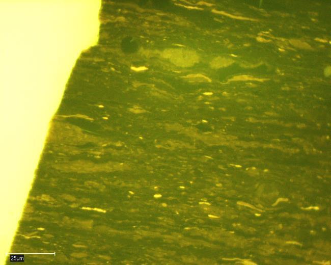
9 and vol % mmf respectively). Liptinite contents are consistently <8.0 vol % mmf in all samples. Microscopic examination under UV light shows the coals contain abundant fluorescing vitrinites with varying degrees of fluorescence, and the liptinites show the strongest fluorescence as expected (Figs. 5a and 5b). The vitrinites in the Breinosa and Colesdalen coals, show stronger fluorescence than those in the Bassen and Lunckefjellet coals. Micrinite, thought to be a relic of oil generation (Taylor et al., 1998) is observed within the coals (fine-grained, white speckles interspersed on some of the vitrinite particles; Fig. 5a-2). Brightly fluorescing oil expulsions from cracks in collodetrinites and collotelinites were observed (Figs. 5a-3 and 5b-3). The interspersed nature of micrinite on vitrinite, and oil expulsion from cracks in vitrinite are consistent with the observations by Orheim et al. (2007). Pyrite framboids (diameter ~2-35 μm) also occur in these coals (Figs. 5b-1 and 5b-2), which indicates oxygen-poor depositional conditions (Wilkin and Barnes, 1997; Wignall et al., 2005), associated with relatively high marine influence on the mires in which the peats (coals) formed Chemical data HI values for the Bassen, Lunckefjellet, Breinosa and Colesdalen samples are: , , and mg HC/g TOC respectively (Table 2). Hydrogen (H) was measured only in the Bassen samples (H between % daf; Table 3). The majority (12 out of the 14) of the Bassen coals are orthohydrous (H between % daf) while the remaining two are subhydrous (H < 4.9 % daf) (Diessel, 1992; Wilkins and George, 2002) with lowest HI values (151 and 153 mg HC/g TOC). There is a strong correlation (R 2 = 0.80) between H and HI for the Bassen samples, which is consistent with previous studies (e.g. Espitalié et al., 1977; Petersen, 2006). Assuming that the good correlation between HI and H holds for the Lunckefjellet, Breinosa and Colesdalen coals, then the HI values may be used as an approximate indicator of whether coals are subhydrous, orthohydrous or perhydrous. In the Longyear seam in Mine 7 (Breinosa), Marshall et al. (2015a) measured H contents ranging between % daf, and reported that the majority of the seam may be termed perhydrous (H > 5.7 % daf), with only the basal 20 cm being orthohydrous (H between % daf). In this study, the HI values at other localities are generally greater than at Bassen, and considering the HI measured in the Longyear coals by Marshall et al. (2015a) ( mg HC/g TOC) are similar to values seen in many of the coals under study, we have therefore assumed that the samples under study are a mixture of orthohydrous and perhydrous coals. J.O. Uguna et al 9
10 Soxhlet extracts (Table 3) range between , , and mg/g in Bassen, Lunckefjellet, Breinosa and Colesdalen respectively. The variable but generally high TOC contents ( %) as expected from coals, and the S2 contents ( mg/g) (Table 3) indicate that some of the coals may be oil-prone. The S1 range between mg/g, and the coals from Breinosa and Colesdalen generally have higher values (mean S1 = 14.5 and 15.2 mg/g respectively) than those from Bassen and Lunckefjellet (mean S1 = 6.8 and 10.7 mg/g respectively) (Table 3). The variations in the S1 and S2 values are in part the result of the variable inorganic matter contents as reflected in the ash yield (between 0.9 and 33.3 wt %; Table 3). Total sulphur (ST) contents range between % in all samples investigated with a general trend of increase from Bassen through Lunckefjellet to Breinosa and Colesdalen Discussion Kerogen typing and petroleum potential On a van Krevelen equivalent diagram using OI vs HI (Fig. 6), the Breinosa coals, the Colesdalen coals and most of the Lunckefjellet coals plot on the Type II kerogen line, while a few Lunckefjellet coals, and all the Bassen coals appear to plot between the Type II and III kerogen lines; this is inconsistent with maceral analysis which shows that the coals are dominated by Type III kerogen. The trend in Fig. 6 therefore reflects the petrographic and fluorescence observations described in previous sections and shown in Figs. 5a and 5b. The majority of the coals are within the maximum range of HI values expected for Cenozoic coals ( mg HC/g TOC) (Petersen, 2006), with some coals showing higher values (> mg HC/g TOC). The coals with high HI values are likely enriched in paraffinic hydrocarbons (e.g. Killops et al., 1998; Petersen, 2005), possibly due to the presence of long-chain aliphatics in the structure of Cenozoic coals in general (e.g. Petersen and Nytoft, 2006; Petersen et al., 2009) or as a result of bacterial decomposition of organic material and consequently liberating aliphatics from lignin within the precursor peat (Marshall et al., 2015a). The high HI values observed appear directly associated with the presence of hydrogen-enriched vitrinites present in the coals, rather than liptinites whose contents are low in these coals (<8 vol %). It is however noted that the presence of sub-microscopic liptinites in some fluorescing vitrinites (Fig. 5a-2., 5b-1 and 5b-4) J.O. Uguna et al 10
11 may be possibly contributing to high HI and overall VR suppression (Hutton and Cook, 1980; George et al., 1994; Hao and Chen, 1992; Petersen and Rosenberg, 1998; Petersen, 2006). Multiple minor S2 peaks with slightly differing Tmax values have been observed in the Rock-Eval 6 pyrograms in this study (Fig. 7). Multiple S2 peaks in immature samples are considered to represent drilling contaminants (Peters, 1986), but given the maturity and use of brine as the drilling medium in this study, drilling mud contamination is not a likely cause. According to Peters (1986), the heavy ends of oil typically appear as S2 rather than S1, resulting in anomalously low Tmax values and in extreme cases, a bimodal S2 peak. Although the Tmax values are high in this study, the observed multiple S2 peaks are possibly related to the release of heavy, liquid hydrocarbons (C25 - C40) volatilized at temperatures higher than normal for S1 (i.e. the S1' of Delvaux et al., 1990) Maturity assessment The maturity range of the coals under study (LoVR % RO, Rank(Sr) ; excluding the Bassen coals, Tmax C) indicates that the coals are within the oil window. The Bassen coals are at the early mature stage (mean values: LoVR = 0.69%RO, Tmax = 430 C), the Lunckefjellet coals are at least at the onset of the middle oil window [mean values: LoVR = 0.78%RO, Tmax = 434 C, Rank(Sr) = 10.3], while the Breinosa and Colesdalen samples are well into the middle oil window [mean values: LoVR = 0.80%RO, Tmax = 443 C, Rank(Sr) = 13.2, and LoVR = 0.88%RO, Tmax = 443 C, Rank(Sr) = 13.4 respectively]. The VR vs Tmax, and LoVR vs Tmax plots show no and borderline weak/moderate correlations (R 2 = 0.28 and 0.51 respectively; Figs. 8a and 8b). The lack of good correlation shown in the VR vs Tmax graph (Fig. 8a) contrasts with the significantly higher correlation shown in the LoVR vs Tmax graph (Fig. 8b). Although there are errors associated with the measurement of both the LoVR and Tmax parameters, the improvement shown in the LoVR vs Tmax graph may reflect the removal of the suppression effect from the VR values, but suppression might still be affecting some of the Tmax values (Newman et al., 1992; Snowdon, 1995; Sykes and Snowdon, 2002). The lack of good correlation of VR vs Tmax and LoVR vs Tmax (Figs. 8a and 8b) contrasts with the good (R 2 not quantified) non-linear correlation between VR and Tmax for the reflectance range <0.5 to 3.0% RO described by Teichmüller and Durand (1983), and by Petersen (2006) who observed a good linear correlation (R 2 = 0.87, n = 487) between these parameters. The large data-set obtained from different countries around the world used in the Petersen (2006) study appears to contain both orthohydrous and perhydrous coals (HI ~0 - J.O. Uguna et al 11
12 mg HC/g TOC), with maturities ranging between <0.5 and >4.0% RO, and the good linear correlation obtained clearly contrasts with the non-linear relationship of Teichmüller and Durand (1983) for a similar range of maturities as those used by Petersen (2006). Teichmüller and Durand (1983) noted that their VR vs Tmax plot was composed of three successive zones, indicating a succession of different modes in coal pyrolysis. Between 0.5% RO (Tmax ~ 425 C) and 1.5% RO (Tmax ~ 475 C), correlation between VR and Tmax is approximately linear, whereas below and above these values, Tmax increases faster than VR. The maturities of coals in this study occur within the linear domain of Teichmüller and Durand (1983), yet in both studies there are some scattering of values in this linear zone. Plots of Rank(Sr) vs Tmax, and Rank(Sr) vs LoVR show weak correlations (R 2 = 0.46 and 0.31 respectively; Figs 8c and 8d). Sykes and Snowdon (2002) approximated the relationship between Rank(Sr), Tmax and VR mainly because Tmax and VR show non-linear increase with temperature prior to catagenesis. Suggate (2002) showed a clear general relationship between Rank(Sr) and VR, with the former being more accurate over the range from peat to the end of the oil window. Because the maturity of the coals in this study occur within the oil window and the linear domain of Teichmüller and Durand (1983), the scattering of values and the poor correlations between LoVR, Tmax and Rank(Sr) is mainly attributed to: 1) measurement inaccuracies, 2) fundamental differences between VR, Tmax and Rank(Sr) even though these parameters are clearly maturity/rank dependent. Tmax is a measure of the maximum rate of release of hydrocarbons from the whole coal during pyrolysis, VR is obtained from only the vitrinite group macerals, while Rank(Sr) is based on VM and CV, which will be affected if the coals have been oxidised prior to sampling or in storage. Tmax suppression is also a factor, albeit to a lesser degree. The range of ash yields (between wt %) mean that mineral matter might be possibly changing the Tmax value due to catalytic reactions between the mineral matter and the macerals (Espitalié, 1986). The mineralogy of the ash yield of the Svalbard coals under study was not analysed, but variable mineralogies produced by the changing depositional conditions particularly within the Longyear seam, as discussed by Marshall et al. (2015a), may be a limiting factor in both the LoVR Tmax and Rank(Sr) Tmax relationships. However, if there is mineral matter effect, there should be a relationship between Tmax and ash yield (or between Tmax and TOC), which is not the case. Therefore, mineral matter does not play a significant role. There is the effect that multiple S2 peaks have on the Tmax which could also be affecting the LoVR Tmax and Rank(Sr) Tmax correlations The relationships between petroleum present, remaining generation potential and maturity J.O. Uguna et al 12
13 Petersen (2006) described oil generation from humic coals as a complex, three-phase process involving: (i) onset of petroleum generation, (ii) petroleum build-up in the coal, and (iii) initial oil expulsion, followed by efficient oil expulsion (corresponding to the effective oil window). The HI of immature samples is an indication of the hydrocarbon phase that a source rock may generate as it is buried. The HImax concept which is defined by the HImax line at VR ~ % RO, Tmax ~ C (Petersen, 2006), or Rank(Sr) ~11 12, Tmax ~ (Sykes and Snowdon, 2002), is the increase in HI at the start of petroleum generation up to a maximum (i.e. stages i and ii of petroleum generation) prior to the onset of oil expulsion. In a LoVR vs HI diagram (Fig. 9a), while the Bassen coals plot to the left of the HImax line (stage i of petroleum generation), some of the Lunckefjellet coals plot on the HImax line (stage ii of petroleum generation). However, the majority of the Lunckefjellet coals, and all the Breinosa and Colesdalen coals plot to the right of the HImax line (stage iii of petroleum generation) in Fig. 9a. On the Rank(Sr) vs HI and Tmax vs HI diagrams (Fig. 9b and 9c respectively), the coals show similarities with the LoVR vs HI diagram as all the Bassen coals and some Lunckefjellet coals are within the stage i generation, some of the Lunckefjellet coals are within stage ii generation, while the remaining coals (i.e. some Lunckefjellet and all the Breinosa and Colesdalen coals) are within stage iii generation. Notably, the HI of the CTB coals do not appear to peak at similar maturity as the world-wide coal dataset of Petersen (2006), with the HImax shifting to higher maturity ( % RO) (Fig. 9a). Conversely, the HImax of the Svalbard coals is a close fit to that of the NZ Coal Band and the envelope of the Sykes and Snowdon (2002) NZ coal data-set, at Rank(Sr) (Fig 9b) and Tmax C (Fig. 9c). On the maturity vs BI plot, the onset of oil generation is indicated by a marked increase in BI, while the peak in BI indicates a change from increasing to decreasing hydrocarbon saturation of the coal pore structure and probably marks the onset of primary gas generation and the efficient expulsion of oil (i.e. the effective oil window) (e.g. Sykes and Snowdon, 2002; Petersen, 2006). On the LoVR vs BI diagram (Fig. 10a), only two Colesdalen coals appear to have reached the efficient oil expulsion stage. The Tmax vs BI diagram (Fig. 10b) shows only one Breinosa coal appear to have reached efficient oil expulsion stage. Conversely, the Rank(Sr) vs BI diagram (Fig. 10c) shows 12 (out of 28) coals (i.e. from Lunckefjellet, Breinosa and Colesdalen) appear to have reached the efficient oil expulsion stage as indicated by the peak in BI at Rank(Sr) ~ This is consistent with observed oil expulsion from some of the coals and in published studies (e.g. Orheim et al., 2007), and thus suggests that there may be a discrepancy in the LoVR - BI and Tmax - BI plots, most likely due to suppression effect. Indeed, the coal rank variation in this study is small compared to the NZ Coal Band, and the data-sets of Sykes J.O. Uguna et al 13
14 and Snowdon (2002) and Petersen (2006), making them more suitable to identify changes in the HI or BI vs maturity trend. However, HI seems to increase from Bassen to Lunckefjellet, and then decrease to Breinosa, with further decrease to Colesdalen, while BI increases from Bassen to Lunckefjellet to Breinosa and Colesdalen which is generally consistent with the maturity trend across these localities. Production index (PI) is <0.10 in all samples (Table 3), which would be expected if the coals were immature (Peters, 1986) but the coals are all within the oil window with some showing evidence of oil generation (micrinite) and oil expulsion. Low PI is consistent with numerous studies showing that coals generally have low S1 and PI values (e.g. Littke et al., 1990; Petersen et al., 2002; Sykes et al., 2014). The presence of mineral matter in pyrolysed coals can influence S1 and S2 values. It has been shown that when mineral matrix (e.g. calcite, illite) is mixed with different kerogens (Types I and III), the S2 yield can be reduced (e.g. Espitalié et al., 1980; Peters, 1986). The S2 reduction is due to the adsorption of heavy pyrolysate components onto clay minerals, which then act as catalysts in the thermal conversion of some compounds to non-volatile char and light materials (S1). Type III kerogen is most prone to this problem because it generates less pyrolysate per gram of OM than Type I or Type II (Peters, 1986). Such a process would mean that there should be an inverse relationship between S1 and S2. However, there is no inverse relationship possibly because: 1) the coals have high TOC contents and have generated much more petroleum than can possibly be adsorbed onto clays and other minerals, and 2) some of the generated petroleum no longer contributed to the S1 as a result of expulsion. Thus, the mineral matter effect may not be significant, although it cannot be ignored especially with the observed variable ash yields. Low PI values could also be due to lack of expulsion Marine influence and the distribution of oil-prone coals within seams across the CTB Sulphur (S) content in peat is closely related to its depositional environment. Generally, peats accumulating in a freshwater environment will have lower S contents than peats accumulating under marine influence mainly due to the availability of marine sulphates (e.g. Chou, 2012). In a study of marine influence on coaly source rocks of the Eocene Mangahewa Fm. in the Taranaki Basin, Sykes et al. (2014) stated that total sulphur (ST) values >0.5 % indicate some degree of marine influence. ST values of % and >1.5 % were considered slightly and strongly marine influenced respectively. Hence, coal ST content should reflect the amount of marine input into the mires in which the peat/coals formed. The Bassen samples show ST contents between % (Table 3), and therefore can be considered slightly marine influenced as per the classification of Sykes et al. (2014). Across J.O. Uguna et al 14
15 Lunckefjellet, ST contents range between % indicating a transect of non-marine to strong marine influence. Most of the Breinosa and Colesdalen samples experienced strong marine influence with ST contents between , and % respectively. Iron (Fe) seems to have a major control on the S chemistry of the Longyear peatlands (Marshall et al., 2015a). Considering atomic weight, the ratio of Fe to S in pyrite is 0.87; thus Fe/S values in excess of 0.87 are required to convert all available S to pyrite. Fe was only measured for 36 (out of the 47) coals under study with the Fe/S ratio (Table 3) averaging 0.77, which is significantly lower than required (0.87) for total conversion to pyrite. In marine influenced locations like Colesdalen, the bulk Fe/S ratio is much lower (0.50). The overall Fe/S data indicates that the amount of available organic S in these coals is higher in more marine influenced coals than in more inland coals. This is consistent with the study of Marshall et al. (2015a) which shows that within the Longyear seam in Mine 7 (Breinosa), there is a shift from Fe-rich (below 80 cm) to S-rich (above 80 cm) sections, which favours oil potential above 80 cm at this location. ST content has been found to control the oil potential of coals (e.g. Sykes et al., 2014; Marshal et al., 2015a and references within). Considering only the Lunckefjellet samples in the Rank(Sr) vs BI diagram (Fig. 10c) for example, the high sulphur coals are generally furthest into the oil window and plot in close proximity to each other. Some high sulphur coals appear to have reached the effective oil window, while the low sulphur coal and all the medium sulphur coals have not. The relationship between marine influence and oil generation and expulsion is further investigated by comparing scatter plots of ST vs BI and ST vs HI between the least mature (Bassen) and most mature (Colesdalen) samples under study (Fig. 11). At Bassen, the ST vs BI and ST vs HI plots show clear positive relationships; conversely, there are negative relationships at Colesdalen. The positive relationships observed at Bassen probably reflects lack of expulsion and low maturity, whilst the negative relationships observed at Colesdalen arises because the coals have commenced expulsion. The more marine influenced samples appear to start generation before the less marine influenced ones, which is consistent with the published effects of sulphur on maturation and petroleum generation in geological basins (Baskin and Peters, 1992; Lewan, 1998). Whilst this observation (i.e. relatively earlier expulsion from the more marine influenced coals) is perhaps due to more favourable conditions for perhydrous coal formation, an outlying high sulphur coal from Lunckefjellet is still at the onset of oil generation (Fig. 10c). This issue may be related to the use of total sulphur (and not organic sulphur) in this study as very high marine influence will J.O. Uguna et al 15
16 generally result in greater ash yield as shown later in this section and in literature (e.g. George et al., 1994). The level of marine influence on the Longyear seam in Mine 7 (Breinosa) has been linked with rising sea levels which resulted in greater oil potential in the upper seam, i.e. from ~80 cm to seam top (Marshall et al., 2015a). Within the Longyear seam at Bassen, ST decreases from ~1.0 % at seam base, to a minimum of ~0.5 % at around 109 cm above seam base, and then increases to ~1.5 % at seam top (Fig. 12a); this trend reflects decreasing sea level from seam base, followed by increasing sea level to the top of seam, which is consistent with the Marshall et al. (2015a) study. At Lunckefjellet BH locality, relative increase in sea level from 90 cm towards the top of the Longyear seam was also observed (Fig. 12b), although there is an ST peak at 80 cm. At Breinosa BH locality, the ST profile from base to top of the Longyear seam (Fig. 12c) also clearly reflects decreasing increasing sea levels. Within the Verkhnij seam in Colesdalen BH locality, a decreasing - increasing sea level trend is not so obvious (Fig. 12d) as in the three localities previously discussed, but the ST contents of the lower part of the seam (mean value from seam base to 57.5 cm = 1.6 % ST) is also lower than in the upper part (mean value from cm to seam top = 2.9 % ST), i.e. excluding the outlier (ST peak at 80.5 cm = 15.9 %). The ST peak in BH (Fig. 12d) possibly resulted from seawater inundation, likely assisted by local topography. The foregoing interestingly shows that sulphur in coal may record instances of coastal retreat associated with base level rise, which is consistent with the study of marine influenced Greta Seam in the Sydney Basin (George et al., 1994). The absence of the decrease increase in sea levels trend in BH is possibly due to greater marine influence associated with closer proximity to the palaeocoastline. This, in addition to the lower vitrinite and higher inertinite contents of the Verkhnij seam compared to the Longyear seam, could also indicate that these two seams are not time equivalent. In practice, the schematic N-S transect across Adventdalen, i.e. from Bassen to Mine 7 to BH (Fig. 13) shows that oil potential on an economic basis (mg/g coal) is dependent upon the balancing of sufficient marine influence to produce and preserve oil-prone materials (as described in Marshall et al., 2015a; Uguna, 2016) with the need for low mineral matter deposition to prevent the dilution of the weakly oil-prone organic carbon within the coals. Towards the coast, high water tables (which favour vitrinite over inertinite formation; e.g. Taylor et al., 1998) are consistent, with greatest sulphur contents and alkalinity; however, the threat of seawater inundation is also greatest in these areas. Inundation results in increasing mineral matter content and limits seam thickness, which J.O. Uguna et al 16
17 consequently limits oil potential. At the basin margins, marine influence is relatively limited, reducing the ability to produce and preserve oil-prone source materials within the coals. Therefore, an intermediate position within the paralic system appears to have the greatest potential for the production of oil-prone coals Conclusions Hydrocarbons present and the remaining generation potential of Spitsbergen coals from Bassen, Lunckefjellet, Breinosa (Longyear seam) and Colesdalen (Verkhnij seam) have been studied by analyses including: maturity, oil potential versus marine influence upon the mires in which the coals formed, and the threshold for oil generation and expulsion. Results show that: On a van Krevelen equivalent diagram, the majority of coals plot on the Type II kerogen line, while others plot between the Types II and III kerogen lines, with HI values between mg HC/g TOC; yet the maceral analysis shows that Type III kerogen predominates. This HI range arises from the presence of fluorescing (oil-prone) vitrinites in the coals, and thus shows that the classical kerogen interpretation lines are not applicable to Cenozoic coals. The PI values are low (<0.10) in all samples, and thus appear to contradict oil generation and expulsion, possibly because: 1) some of the generated petroleum no longer contributed to the S1 as a result of expulsion, and 2) lack of expulsion if part of the generated hydrocarbons is trapped in the coal matrix and not released during thermal vaporisation, but are released during the S2 phase when the kerogen breaks down The VR of the coals are suppressed. Suppression was removed by using the modification based on the HI values of the coals (Lo, 1993); this shows that all samples are within the oil generation window, with mean LoVR values of 0.68, 0.78, 0.80 and 0.88% RO in Bassen, Lunckefjellet, Breinosa and Colesdalen respectively. The Rank(Sr) scale of Suggate (200, 2002) shows mean values of 10.3, 13.2 and 13.4 in Lunckefjellet, Breinosa and Colesdalen respectively. Both the LoVR and Rank(Sr) values are consistent with the Tmax values which average 430, 434, 443 and 443 C at these locations respectively. The correlations between VR, LoVR, Tmax and Rank(Sr) are poor due to: 1) suppression effect on VR, with lesser suppression effect on Tmax and LoVR and 2) analytical issues. 521 J.O. Uguna et al 17
18 The least mature samples in the CTB data-set are close to the early mature stage of the oil window (i.e. ~0.7% RO), and thus the threshold for oil generation could not be clearly defined. However, as the maturation trend of the CTB coals closely follows that of the NZ Coal Band and the NZ coal dataset of Sykes and Snowdon (2002), the oil generation threshold for these coals is likely at Rank(Sr) ~8 9, Tmax ~ C as indicated by the rise in BI. Some of the Lunckefjellet coals and all the Breinosa and Colesdalen coals have either reached or progressed beyond the threshold of oil expulsion as indicated by the peak in HI at Rank(Sr) ~11 12, LoVR ~ % RO, Tmax ~ C, while the remainder Lunckefjellet coals and all the Bassen coals are at relatively earlier stages of the oil window. Some of the Lunckefjellet and Breinosa coals, and all the Colesdalen coals appear to have reached the effective oil window as indicated by the peak in BI at Rank(Sr) ~ The observed closeness between the maturation pathways of the CTB coals and the NZ coals emphasises the similarities between the two oil generating systems Oil potential resulted from marine sulphate deposition upon the mires in which the peats/coals formed, and subsequent marine sulphur incorporation during diagenesis. The sulphur contents range between % in the coals, and thus indicate non-marine to strong marine influence. The level of marine influence show clear positive relationships between BI and HI within the Bassen samples likely because they are early mature and have not started expelling oil. Conversely, the level of marine influence shows clear negative relationships with BI and HI within the Colesdalen samples because they have commenced expulsion and probably reached the effective oil window. The more marine influenced coals appear to start petroleum generation relatively earlier compared to the less marine influenced ones. Highest hydrocarbon yields are expected in an intermediate position on the coastal plain where marine sulphur is sufficient to preserve oil-prone components, but mineral matter contents are low enough not to dilute TOC. Results indicate that S in coal may record instances of coastal retreat associated with base level rise, which has implications for the stratigraphic interpretations of coals Acknowledgements Sincere appreciation and thanks to Store Norske AS for the financial sponsorship, the provision of samples and support during field work in Svalbard. The University of Nottingham and The University Centre In Svalbard are gratefully acknowledged for the lead author s studentship opportunities. The J.O. Uguna et al 18
19 lead author is particularly grateful for been awarded the University of Nottingham s Dean of Engineering Research Scholarship for International Excellence. Special thanks to the Centre for Environmental Geochemistry, British Geological Survey, Nottingham, for Rock-Eval 6 pyrolysis References Banerjee, A., Sinha, A.K., Jain, A.K., Thomas, N.J., Misra, K.N., Chandra, K., A mathematical representation of Rock-Eval hydrogen index vs Tmax profiles. Organic Geochemistry 28 (1/2), Baskin, D.K., Peters, K.E., Early Generation Characteristics of a Sulphur-Rich Monterey Kerogen. AAPG Bulletin 76 (1), Bergh, S.G., Braathen, A., Andresen, A., Interaction of basement-involved and thin-skinned tectonism in the Tertiary fold-thrust belt of central Spitsbergen, Svalbard. AAPG Bulletin 81(4), Braathen, A., Bælum, K., Christiansen, H.H., Dahl, T., Eiken, O., Elvebakk, H., Hansen, F., Hanssen, T.H., Jochmann, M., Johansen, T.A., Johnsen, H., Larsen, L., Lie, T., Mertes, J., Mørk, A., Mørk, M. B., Nemec, W., Olaussen, S., Oye, V., Rød, K., Titlestad, G.O., Tveranger, J., Vagle, K., The Longyearbyen CO2 Lab of Svalbard, Norway - initial assessment of the geological conditions for CO2 sequestration. Norwegian Journal of Geology 92, Brown, H.R., Cook, A.C., Taylor, G.H., Variations in the properties of vitrinite in isometamorphic coal. Fuel 43, Bruhn, R., Steel, R., High-resolution sequence stratigraphy of a clastic foredeep succession (Paleocene, Spitsbergen): An example of peripheral-bulge-controlled depositional architecture. Journal of Sedimentary Research 73 (5), Carr, A.D., Suppression and retardation of vitrinite reflectance, part 1. Formation and significance for hydrocarbon generation. Journal of Petroleum Geology 23, J.O. Uguna et al 19
20 Chou, C-L., Sulfur in coals: A review of geochemistry and origins. International Journal of Coal Geology 100, Delvaux, D., Martin, H., Leplat, P., Paulet, J., Comparative Rock-Eval pyrolysis as an improved tool for sedimentary organic matter analysis. Organic Geochemistry 16, Eldholm, O., Thiede, J., Taylor, E., Evolution of the Norwegian continental margin: background and objectives. In Eldholm, O., Thiede, J., Taylor, E., et al., Proc. ODP, Init. Repts., 104: College Station, TX (Ocean Drilling Program), Espitalié, J., Use of Tmax as a maturation index for different types of organic matter. Comparison with vitrinite reflectance. In: Burrus, J. (Ed.), Thermal modelling in sedimentary basins. Paris: Editions Technip Espitalié, J., Laporte, J.L., Madec, M., Marquis, F., Leplat, P., Paulet, J., Boutefeu, A., Methode rapide de caracterisation des roches meres, de leur potential petrolier et de leur degre d'evolution. Rev. Inst. Fr. Per. 32, Espitalié, J., Madec, M., Tissot, B., Role of mineral matrix in kerogen pyrolysis: influence on petroleum generation and migration. AAPG Bulletin 4, Gaina, C., Gernigon, L., Ball, P., Palaeocene-Recent plate boundaries in the NE Atlantic and the formation of the Jan Mayen microcontinent. Journal of the Geological Society 166, George, S.C., Smith, J.W., Jardine, D.R., Vitrinite reflectance suppression in coal due to marine transgression: Case study of the organic geochemistry of the Greta Seam, Sydney Basin. Australian Petroleum Exploration Association Journal 34, Hao, F., Chen, J., The cause and mechanism of vitrinite reflectance anomalies. Journal of Petroleum Geology 15, J.O. Uguna et al 20
21 Harland, W.B., Anderson, L.M., Manasrah, D., Butterfield, N.J., Challinor, A., Doubleday, P.A., Dowdeswell, E.K., Dowdeswell, J.A., Geddes, I., Kelly, S.R.A., Lesk, E.L., Spencer, A.M. Stephens, C.F., The Geology of Svalbard. Geological Society Memoir 17, Helland-Hansen, W., Sedimentation in a Paleogene foreland basin, Spitsbergen. AAPG Bulletin 74, Hutton, A.C., Cook, A.C., Influence of alginite on reflectance of vitrinite from Joadja, NSW, and some other coals and oil shales containing alginite. Fuel 59, International Organisation for Standardisation (ISO) (2009) Methods for the petrographic analysis of coals - Part 3: Method of determining maceral group composition - ISO :2009, ISO, Geneva International Organisation for Standardisation (ISO) (2009) Methods for the petrographic analysis of coals - Part 5: Method of determining microscopically the reflectance of vitrinite - ISO :2009, ISO, Geneva Jarvie, D.M., Claxton, B.L., Henk, F.B., Breyer, J.T., Oil and shale gas from the Barnett Shale, Ft. Worth Basin, Texas (Abstracts). AAPG Bulletin 85, 100 pp Killops, S.D., Gunnel, R.H., Suggate, R.P., Sykes, R., Peters, K.E., Walters, C., Woolhouse, A.D., Weston, R.J., Boudou, J.P., Predicting generation and expulsion of paraffinic oil from vitrinite rich coals. Organic Geochemistry 29 (1-3), Laban, K.L., Atkins, B.P., The determination of minor and trace element associations in coal using a sequential microwave digestion procedure. International Journal of Coal Geology 4 (41), Leever, K.A., Gabrielsen, R.H., Faleide, J.I., Braathen, A., A transpressional origin for the West Spitsbergen fold-and-thrust belt: Insight from analog modeling. Tectonics 30 (2), TC2014, DOI: /2010TC J.O. Uguna et al 21
22 646 Lewan, M.D., Sulphur-radical control on petroleum formation rates. Nature 391, Littke, R., Leythaeuser, D., Radke, M., Schaefer, R.G., Petroleum generation and migration in coal seams of the Carboniferous Ruhr Basin, northwest Germany. In: Durand, B., Behar, F. (Eds.), Advances in organic geochemistry 1989, part I, organic geochemistry in petroleum exploration. Organic Geochemistry 16, Livshits, Y.Y., Paleogene deposits and the platform structure of Svalbard. Skrifter-Norsk Polarinstitutt 159, 50 pp Lo, H.B., Correction criteria for the suppression of vitrinite reflectance in hydrogen-rich kerogens: preliminary guidelines. Organic Geochemistry 20 (6), Marshall, C.J., Palaeogeographic development and economic potential of the coal-bearing Palaeocene Todalen Member, Spitsbergen. Ph.D. Thesis, University of Nottingham, United Kingdom Marshall, C., Large, D.J., Meredith, W., Snape, C.E., Uguna, C., Spiro, B.F., Orheim, A., Jochmann, M., Mokogwu, I., Wang, Y., Friis, B., 2015a. Geochemistry and petrology of Palaeocene coals from Spitsbergen - Part 1: oil potential and depositional environment. International Journal of Coal Geology 143, Marshall, C., Uguna, J., Large, D.J., Meredith, W., Jochmann, M., Friis, B., Vane C., Spiro, B.F., Snape, C.E., Orheim, A., 2015b. Geochemistry and petrology of Palaeocene coals from Spitzbergen - Part 2: maturity variations and implications for local and regional burial models. International Journal of Coal Geology 143, Mukhopadhyay, P.K., Vitrinite reflectance as maturity parameter: petrographic and molecular characterization and its applications to basin modelling. In: Mukhopadhyay, P.K., Dow, W.G. (Eds.), Vitrinite reflectance as a maturity parameter: applications and limitations: American Chemical Society Symposium Series 570, J.O. Uguna et al 22
23 Müller, R.D., Spielhagen, R.F., Evolution of the Central Tertiary Basin of Spitsbergen: towards a synthesis of sediment and plate tectonic history. Palaeogeography, Palaeoclimatology, Palaeoecology 80 (2), Nagy, J., Delta-influenced foraminiferal facies and sequence stratigraphy of Paleocene deposits in Spitsbergen. Palaeogeography Palaeoclimatology Palaeoecology 222, Newman, J., Price, L.C., Johnston, J.H., Hydrocarbon source potential and maturation in Eocene New Zealand vitrinite-rich coals: insights from traditional coal analyses, and Rock-Eval and biomarker studies. Journal of Petroleum Geology 20, Orheim, A., Bieg, G., Brekke, T., Horseide, V., Stenvold, J., Petrography and geochemical affinities of Spitsbergen Paleocene coals, Norway. International Journal of Coal Geology 70, Peters, K.E., Guidelines for evaluating petroleum source rock using programmed pyrolysis. AAPG Bulletin 70 (3), Petersen, H.I., A re-consideration of the oil window for humic coal and kerogen type III source rocks. Journal of Petroleum Geology 25, Petersen, H.I., Oil generation from coal source rocks: the influence of depositional conditions and stratigraphic age. Geological Survey of Denmark and Greenland, Bulletin 7, Petersen, H.I., The petroleum generation potential and effective oil window of humic coals related to coal composition and age. International Journal of Coal Geology 67 (4), Petersen, H.I., Andsbjerg, J., Bojesen-Koefoed, J.A., Nytoft, H.P., Coal-generated oil: source rock evaluation and petroleum geochemistry of the Lulita Oilfield, Danish North Sea. Journal of Petroleum Geology 23, J.O. Uguna et al 23
24 Petersen, H.I., Bojesen-Koefoed, J.A., Nytoft, H.P., Source rock evaluation of Middle Jurassic coals, northeast Greenland, by artificial maturation: aspects of petroleum generation from coal. AAPG Bulletin 86, Petersen, H.I., Nytoft, H.P., Oil generation capacity of coals as a function of coal age and aliphatic structure. Organic Geochemistry 37, Petersen, H.I., Rosenberg, P., Reflectance retardation (suppression) and associated rock properties related to Middle Jurassic coals, Danish North Sea hydrogen-enriched vitrinite. Journal of Petroleum Geology 21, Petersen, H.I., Sherwood, N., Mathiesen, A., Fyhn, M.B.W., Dau, N.T., Russell, N., Bojesen-Koefoed, J.A., Nielsen, L.H., Application of integrated vitrinite reflectance and FAMM analyses to solve problems in thermal maturity assessment of the northeastern Malay Basin, offshore SW Vietnam: implications for petroleum prospectivity evaluation. Marine and Petroleum Geology 26, Petersen, H.I., Vosgerau, H., Composition and organic maturity of Middle Jurassic coals, North- East Greenland: evidence for liptinite-induced suppression of huminite reflectance. International Journal of Coal Geology 41, Petersen, T.G., Thomsen, T.B., Olaussen, S., Stemmerik, L., Provenance shifts in an evolving Eurekan foreland basin; the Tertiary Central Basin, Spitsbergen. Journal Geological Society London 173, Piepjohn, K., von Gosen, W., Läufer, A., McClelland W.C., Estrada, S., Ellesmerian and Eurekan fault tectonics at the northern margin of Ellesmere Island (Canadian High Arctic) Z. Dt. Ges. Geowiss. German Journal of Geoscience 164, Pickel, W., Kus, J., Flores, D., Kalaitzidis, S., Christanis, K., Cardott, B.J., Misz-Kennan, M., Rodrigues, S., Hentschel, A., Hamor-Vido, M., Crosdale, P., Wagner, N., ICCP, Classification of liptinite ICCP System International Journal of Coal Geology 169, J.O. Uguna et al 24
25 Powell, T.G., Boreham, C.J., Terrestrially sourced oils: where do they exist and what are our limits of knowledge? - A geochemical perspective. In: Scott, A.C., Fleet, A.J. (Eds.), coal and coal- bearing strata as oil-prone source rocks? Geological Society Special Publication 77, Raymond, A.C., Murchison, D.G., Influence of exinitic macerals on the reflectance of vitrinite in Carboniferous sediments of the Midland Valley of Scotland. Fuel 70, Snowdon, L.R., Rock-Eval Tmax suppression: documentation and amelioration. AAPG Bulletin 79, Suggate, R.P., The Rank(Sr) scale: its basis and its applicability as a maturity index for all coals. New Zealand Journal of Geology and Geophysics 43, Suggate, R.P., Application of Rank(Sr), a maturity index based on chemical analyses of coals. Marine and Petroleum Geology 19, Sykes, R., Snowdon, L.R., Guidelines for assessing the petroleum potential of coaly source rocks using Rock-Eval pyrolysis. Organic Geochemistry 33, Sykes, R., Volk, H., George, S.C., Ahmed, M., Higgs, K.E., Johansen, P.E., Snowdon, L.R., Marine influence helps preserve the oil potential of coaly source rocks: Eocene Mangahewa Formation, Taranaki Basin, New Zealand. Organic Geochemistry 66, Taylor, G.H., Reflections on reflectance. Advances in the Study of the Sydney Basin. 25 th Newcastle Symposium Proceedings, Taylor, G.H., Liu, S.Y., TEM and coal structure. In: Moulin, J.A., Nater, K.A., Chermin, H.A.G. (Eds.), Proceedings, International Conference on Coal Science, Maastricht, J.O. Uguna et al 25
26 Taylor, G.H., Teichmüller, M., Davis, A., Diessel, C.F.K., Littke, R., Robert, P., Organic Petrology. Berlin: Gebrüder Borntraeger Teichmüller, M., Teichmüller, R., Diagenesis of coal (coalification). In: Larson, G., Chilingar, G.V. (Eds.), Diagenesis in sediments and sedimentary rocks. Amsterdam: Elsevier Tegner, C., Storey, M., Holm, P.M., Thorarinsson, S.B., Zhao, X., Lo, C.H., Knudsen, M.F., Magmatism and Eurekan deformation in the High Arctic Large Igneous Province: 40Ar 39Ar age of Kap Washington Group volcanics, North Greenland. Earth and Planetary Science Letters 303(3-4), Teichmüller, M., The genesis of coal from the viewpoint of coal petrology. International Journal of Coal Geology 12, Teichmüller M., Durand B., Fluorescence microscopical rank studies on liptinites and vitrinite in peat and coals, and comparison with the results of the Rock-Eval pyrolysis. International Journal of Coal Geology 2, Uguna, J., Maturity, source rock and retorting potential of the perhydrous coals in the Central Tertiary Basin, Spitsbergen. Ph.D. Thesis, University of Nottingham, United Kingdom Wignall, P.B., Newton, R., Brookfield, M.E., Pyrite framboid evidence for oxygen-poor deposition during the Permian-Triassic crisis in Kashmir. Palaeogeography Palaeoclimatology Palaeoecology 216, Wilkin, R.T., Barnes, H.L., Formation processes of framboidal pyrite. Geochim. Cosmochim. Acta 61, Wilkins, R.W.T., Buckingham, C.P., Sherwood, N., Russell, N.J., Faiz, M., Kurusingal, J., The current status of the FAMM thermal maturity technique for petroleum exploration in Australia, APPEA Journal 38, J.O. Uguna et al 26
27 Wilkins, R.W.T., Wilmshurst, J.R., Russel, N.J., Hladky, G., Ellacott, M.V., Buckingham, C., Fluorescence alteration and the suppression of vitrinite reflectance. Organic Geochemistry 18 (5), Table captions Table 1. Coal samples, seams and locations (all samples are part of Marshall et al. 2015b) Table 2. Maceral composition, VR, LoVR and Rank(Sr) data. Tel = Telinite, Clt = Collotelinite, Cld = Collodetrinite, Vtd = Vitrodetrinite, Cpg = Corpogelinite, F = Fusinite, Sf = Semifusinite, Fg Funginite, Mac = Macrinite, Mic = Micrinite, In = Inertodetrinite, Sp = Sporinite, Cut = Cutinite, Res = Resinite, Bit = Bituminite, Sb = Suberinite, Lpd = Liptodetrinite. STDEV range for VR and LoVR = and % RO respectively based on 100 RO measurements per sample Table 3. Chemical data: Rock-Eval pyrolysis, hydrogen (H), Soxhlet yield, total sulphur (ST), iron (Fe), Fe/S ratio, coal ash, volatile matter (VM) and calorific value (CV). HI in mg HC/g TOC. OI in mg (CO+CO2)/g TOC. BI (Bitumen Index) = (S1*100)/TOC in mg HC/g TOC. H in wt % daf Figure captions (Printed version of figures in black-and-white) Fig. 1. The van Mijenfjorden Group representing the sedimentary infill of the CTB, Spitsbergen (Adapted from Marshal et al., 2015b). Note: multiple coal seams (S = Svea, T = Todalen, L = Longyear, Vs. = Svarteper, A = Askeladden) occurring within the basal Todalen Mb. Fig. 2. Map of the northern Central Tertiary Basin in Spitsbergen showing sampling localities and sample types (modified from Fig. 3. Model for correcting VR suppression (modified from Fig. 1 of Lo, 1993). Note: the estimated true VR (RT) in Bassen, Lunckefjellet, Breinosa and Colesdalen are 0.68, 0.78, 0.80 and 0.88% RO J.O. Uguna et al 27
28 respectively. STDEV of Lo (1993) corrected VR are 0.02, 0.04, 0.05 and 0.05% RO respectively in all four areas Fig. 4. Determination of the Rank(Sr) of the CTB coals using CV and VM (after Suggate, 2002) Fig. 5a. Photomicrographs showing the oil-prone nature of investigated coals. 1) Fluorescing vitrinites and liptinites in sample Ba1 from Bassen. 2) Fluorescing vitrinite groundmass with abundant micrinite (fine granular white macerals interspersed on vitrinite), abundant liptodetrinite (Lpd) and bituminite Bit in sample L12 from Lunckefjellet. 3) Oil expulsion from crack on a collotelinite in sample L13 from Lunckefjellet. 4) Fluorescing vitrinites in sample Br2 from Breinosa. C = collotelinite, Co = corpogelinite, Cd = collodetrinite, R = resinite, Sp = Sporinite, Cu = cutinite, F = fusinite, Sf = semifusinite, In = inertodetrinite, Fg = funginite. Black/white photo = normal light. Coloured photo = UV light Fig. 5b. Photomicrographs showing the oil-prone nature of investigated coals. 1) Cutinite (Cu), resinite (R), sporinite (Sp) and liptodetrinite (Lpd) in a perhydrous collodetrinite (Cd) groundmass in sample Br4 from Breinosa. 2) Suberinite (Sb) cell walls are typically in-filled with fluorescing corpogelinites (Co) in sample Br4 from Breinosa. 3) Oil expulsion from crack on perhydrous collodetrinite in sample Br4 from Breinosa. 4) Detrovitrinite showing stronger fluorescence than collotelinite in sample C2 from Colesdalen. Note: pyrite (P) framboids (diameter ~2-35 µm) in (1) and (2) are indicative of oxygenpoor deposition associated with relatively high marine influence. R = resinite, Sf = semifusinite. Black/white photo = normal light. Coloured photo = UV light Fig. 6. van Krevelen equivalent diagram of the CTB coals. The coals plot on the Type II kerogen line and between the Types II and III kerogen lines despite being predominately composed of vitrinites Fig. 7. Rock-Eval 6 pyrogram (drawn to scale) showing multiple minor S2 peaks in sample Br4 from Breinosa BH locality. The multiple S2 peaks are possibly associated with the release of heavy, liquid hydrocarbons volatilized at temperatures higher than normal for S Fig. 8a. VR vs Tmax plot for the CTB coals. 858 J.O. Uguna et al 28
29 859 Fig. 8b. LoVR vs Tmax plot for the CTB coals Fig. 8c. Rank(Sr) vs Tmax plot for the CTB coals Fig. 8d. Rank(Sr) vs LoVR plot for the CTB coals Fig. 9a. LoVR vs HI plot for the CTB coals (after Petersen, 2006). Samples plotting to the left of and on the HImax line are in stages i and ii petroleum generation respectively, while those plotting to the right of the HImax line are in stage iii petroleum generation. Note: the HImax line of the CTB coals shifts towards higher maturity compared to the world-wide coal data-set (shaded area) of Petersen (2006) Fig. 9b. Rank(Sr) vs HI plot for the CTB coals (after Sykes and Snowdon, 2002). Note: the trend of the CTB coals parallels that of the NZ Coal Band (shaded area) Fig. 9c. Tmax vs HI plot for the CTB coals (after Sykes and Snowdon, 2002). Note: the trend of the CTB coals closely follows that of the NZ Coal Band (shaded area) Fig. 10a. LoVR vs BI plot for the CTB coals under study (after Petersen, 2006). Note: the shaded area is the world-wide coal data-set of Petersen (2006) Fig. 10b. Tmax vs BI plot for the CTB coals (after Sykes and Snowdon, 2002). Note: the trend of the CTB coals parallels that of the NZ Coal Band (shaded area) Fig. 10c. Rank(Sr) vs BI plot for the CTB coals (after Sykes and Snowdon, 2002). Note: the trend of the CTB coals closely follows that of the NZ Coal Band (shaded area). Fig. 11. Comparing the ST vs BI and ST vs HI plots of the Bassen and Colesdalen coals to show the influence of sulphur in petroleum generation. Note: the positive correlation observed for Bassen is probably because oil expulsion has not started, while the negative relationship at Colesdalen is because the coals are already expelling oil. 888 J.O. Uguna et al 29
30 Fig. 12. Sulphur profiles within seams and across sampled localities in the CTB. Note: the sizes of the plots are proportional and reflect the relative seam thicknesses and ST contents Fig. 13. A schematic N-S transect across an idealised Adventdalen section (i.e. from Bassen to Mine 7 to BH4-2009) showing the relationship between oil potential and marine influence. Note: Mine 7 data are from Marshall et al. 2015a; Uguna, J.O. Uguna et al 30
31 895 Table 1 Sample ID Area Location and sample type Seam Drill depth (m) Median sample position above seam base (m) Core/sample length (m) 896 Ba1 Bassen Outcrop section Longyear Ba2 Bassen Outcrop section Longyear Ba3 Bassen Outcrop section Longyear Ba4 Bassen Outcrop section Longyear Ba5 Bassen Outcrop section Longyear Ba6 Bassen Outcrop section Longyear Ba7 Bassen Outcrop section Longyear Ba8 Bassen Outcrop section Longyear Ba9 Bassen Outcrop section Longyear Ba10 Bassen Outcrop section Longyear Ba11 Bassen Outcrop section Longyear Ba12 Bassen Outcrop section Longyear Ba13 Bassen Outcrop section Longyear Ba14 Bassen Outcrop section Longyear L1 Lunckefjellet BH Longyear L2 Lunckefjellet BH Longyear L3 Lunckefjellet BH Longyear L4 Lunckefjellet BH Longyear L5 Lunckefjellet BH Longyear L6 Lunckefjellet BH Longyear L7 Lunckefjellet BH Longyear L8 Lunckefjellet BH Longyear L9 Lunckefjellet BH Longyear L10 Lunckefjellet BH Longyear L11 Lunckefjellet BH Longyear L12 Lunckefjellet BH Longyear L13 Lunckefjellet BH Longyear L14 Lunckefjellet BH Longyear L15 Lunckefjellet BH Longyear L16 Lunckefjellet BH Longyear L17 Lunckefjellet BH Longyear L18 Lunckefjellet BH Longyear L19 Lunckefjellet BH Longyear L20 Lunckefjellet BH6A-2007 Longyear L21 Lunckefjellet BH6A-2007 Longyear Br1 Breinosa BH Longyear Br2 Breinosa BH Longyear Br3 Breinosa BH Longyear Br4 Breinosa BH Longyear Br5 Breinosa BH Longyear C1 Colesdalen BH Verkhnij C2 Colesdalen BH Verkhnij C3 Colesdalen BH Verkhnij C4 Colesdalen BH Verkhnij C5 Colesdalen BH Verkhnij C6 Colesdalen BH Verkhnij C7 Colesdalen BH Verkhnij J.O. Uguna et al 31
32 897 Table Sample ID Maceral composition (vol % mmf) Maturity parameters Tel Clt Cld Vtd Cpg F Sf Fg Mac Mic In Sp Cut Res Bit Sb Lpd VR LoVR Rank(Sr) Ba Ba Ba Ba Ba Ba Ba Ba Ba Ba Ba Ba Ba Ba L L L L L L L L L L L L L L L L L L L L L Br Br Br Br Br C C C C C C C J.O. Uguna et al 32
33 899 Table 3 Sample ID S1 (mg/g) S2 (mg/g) T max ( C) TOC (%) HI OI PI BI H Soxhlet yield (mg/g) ST (%) Fe (%) Fe/S Ash (%) VM (%) CV (Btu/lb) Ba Ba Ba Ba Ba Ba Ba Ba Ba Ba Ba Ba Ba Ba L L L L L L L L L L L L L L L L L L L L L Br Br Br Br Br C C C C C C C J.O. Uguna et al 33


34 900 Fig. 1 Quaternary Erosion Hollendardalen Fm Kolthoffberget Mb 901 Cretaceous (Aptian/Albian) J.O. Uguna et al 34

35 902 Fig. 2 N Isfjorden Longyearbyen Bassen Adventdalen Nordenskioldfjellet Breinosa Mine 7 BH Colesdalen Synndalen BH Lunckefjellet BH6A-2007 BH BH BH Svea Nord Mine Reindalen Sveagruva 903 Key Borehole samples Outcrop samples Operating mines 4 km Van Mijenfjorden J.O. Uguna et al 35
36 Measured Vitrinite Reflectance - VR (%R o ) 904 Fig Bassen LoVR = 0.68% R o Lunckefjellet LoVR = 0.78% R o Breinosa LoVR = 0.80% R o Colesdalen LoVR = 0.88% R o Line of HI 100 Line of HI = 300 Line of HI = 600 Line of HI = True Vitrinite Reflectance - LoVR(%R o ) 906 J.O. Uguna et al 36
37 Volatile Matter (%, dmmsf) 907 Fig Lunckefjellet n = Breinosa Colesdalen NZ Coal Band Calorific Value (Btu/lb, dmmsf) J.O. Uguna et al 37


38 909 Fig. 5a Cu R Cd Cd C Co R Co Sp Fg 25µm 25µm Cu Bit Sp Lpd 25µm 1 25µm 2 Sf F F Sf In Collotelinite R 25µm 25µm R Co µm 3 25µm 4 J.O. Uguna et al 38


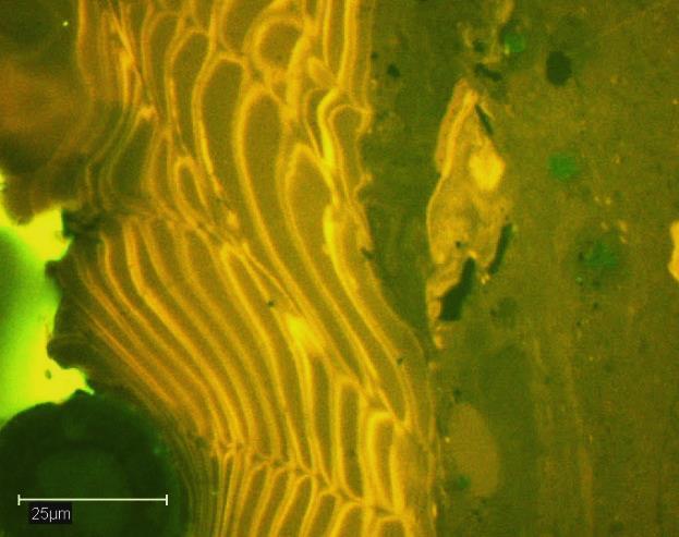
39 911 Fig. 5b Sp Co Cd Co Co P 25µm R P Cu Cd Cu P 25µm F Sb Co P Cd 25µm 1 25µm 2 Collotelinite Detrovitrinite R Semifusinite 10µm 25µm µm 3 25µm 4 J.O. Uguna et al 39
Source Rocks. I Source rocks. II Discussion of geochemical parameters. III Global distribution of source rocks
 Source Rocks I Source rocks II Discussion of geochemical parameters III Global distribution of source rocks Source rock A petroleum source rock is generally recognized as a fine grained sedimentary
Accepted Manuscript. Clement N. Uguna, Andrew D. Carr, Colin E. Snape, Will Meredith, Iain C. Scotchman, Andrew Murray, Christopher H.
 Accepted Manuscript Impact of high water pressure on oil generation and maturation in Kimmeridge Clay and Monterey source rocks: Implications for petroleum retention and gas generation in shale gas systems
Maturity Issues within Palaeocene Coal, Spitsbergen: Implications for local and regional burial and uplift models
 1 2 Maturity Issues within Palaeocene Coal, Spitsbergen: Implications for local and regional burial and uplift models 3 4 5 Chris Marshall a*, Jacob Uguna a, David J. Large a, Will Meredith a, Malte Jochmann
Rock Eval, Total Organic Carbon of the 29 rock samples from Mali. Unfiled Report April
 Rock Eval, Total Organic Carbon of the 29 rock samples from Mali Unfiled Report April 26 2011 Dear Sir, We have analyzed your 29 rock samples from Mali. The rock samples were pyrolyzed using our Rock-Eval
Geochemical Appraisal using Vitrinite Reflectance and Rock-Eval Data, of Shishtu and Sardar Formations Central Iran
 Geochemical Appraisal using Vitrinite Reflectance and Rock-Eval Data, of Shishtu and Sardar Formations Central Iran Jahangard. A. A, Alizadeh. B, Hosseini. S. H. Department of Geology, Faculty of Earth
Kinetic modelling of kerogen cracking during oil shale process : influence of organic matter source F. Behar and P. Allix
 Kinetic modelling of kerogen cracking during oil shale process : influence of organic matter source F. Behar and P. Allix 1 General outline! I Introduction! II Kerogen characterization Definition of the
Evaluation of geological characteristics of the New Albany Shale as a potential liquids-from- shale play in the Illinois Basin
 2014 Eastern Unconventional Oil and Gas Symposium - November 5-7, 2014 in Lexington, Kentucky, USA http://www.euogs.org Evaluation of geological characteristics of the New Albany Shale as a potential liquids-fromshale
A new approach to interpreting relationship between Rock-Eval S2 and TOC data for source rock evaluation based on regression analyses
 Geopersia 5 (), 25, PP. -6 A new approach to interpreting relationship between Rock-Eval S2 and TOC data for source rock evaluation based on regression analyses Ali Shekarifard School of Chemical Engineering,
Improved Calibration of the Absolute Thermal Maturity of Coal-Sourced Oils and Gas Condensates Using PLS Regression. R. Sykes 1 and K.-G.
 Improved Calibration of the Absolute Thermal Maturity of Coal-Sourced Oils and Gas Condensates Using PLS Regression R. Sykes 1 and K.-G. Zink 1 Search and Discovery Article#10480 (2013)** Posted January
Oil & Gas. From exploration to distribution. Week 1 V05 Origin of hydrocarbon resources part 1. Jean-Pierre Deflandre
 Oil & Gas From exploration to distribution Week 1 V05 Origin of hydrocarbon resources part 1 Jean-Pierre Deflandre W1V5 Origin of hydrocarbon resources1 p. 1 Introduction to hydrocarbon resources You will
Tertiary Oil-Prone Coals and Carbonaceous Shales Identified as the Potential Source Rock of the Caracara Sur Oil Field in the Llanos Basin, Colombia*
 Click to view presentation slides (3 mb). Tertiary Oil-Prone Coals and Carbonaceous Shales Identified as the Potential Source Rock of the Caracara Sur Oil Field in the Llanos Basin, Colombia* M.F. García-Mayoral
Mokogwu, Ikechukwu (2011) Generation and migration of oil from perhydrous Longyear coal. MSc(Res) thesis, University of Nottingham.
 Generation and migration of oil from perhydrous Longyear coal. MSc(Res) thesis, University of Nottingham.") Mokogwu, Ikechukwu (2011) Generation and migration of oil from perhydrous Longyear coal. MSc(Res) thesis, University of Nottingham. Access from the University of Nottingham repository: http://eprints.nottingham.ac.uk/12382/3/generation_and_migration_of_oil_from_perhydrous
Mokogwu, Ikechukwu (2011) Generation and migration of oil from perhydrous Longyear coal. MSc(Res) thesis, University of Nottingham. Access from the University of Nottingham repository: http://eprints.nottingham.ac.uk/12382/3/generation_and_migration_of_oil_from_perhydrous
21. GEOCHEMICAL ANALYSIS OF SAMPLES FROM SITES 397 AND 398
 21. GEOCHEMICAL ANALYSIS OF SAMPLES FROM SITES 397 AND 398 Daniel B. Pearson, The Superior Company, Houston, Texas and Wallace G. Dow, Getty Company, Houston, Texas 1 INTRODUCTION Economic interest in
Petroleum Systems (Part One) Source, Generation, and Migration
 Source, Generation, and Migration") Petroleum Systems (Part One) Source, Generation, and Migration GEOL 4233 Class January 2008 Petroleum Systems Elements Source Rock Migration Route Reservoir Rock Seal Rock Trap Processes Generation Migration
Petroleum Systems (Part One) Source, Generation, and Migration GEOL 4233 Class January 2008 Petroleum Systems Elements Source Rock Migration Route Reservoir Rock Seal Rock Trap Processes Generation Migration
Evaluation of Neocomian Shale source rock In Komombo Basin, Upper Egypt
 Evaluation of Neocomian Shale source rock In Komombo Basin, Upper Egypt Abdelhady, A. 1, Darwish, M. 2, El Araby, A. 3 and Hassouba, A. 4 1 DEA Egypt, Cairo, Egypt 2 Geology Department, Faculty of Science,
SHALE GAS/ OIL: OPPORTUNITIES CMPDI S ENDEAVOURS
 SHALE GAS/ OIL: OPPORTUNITIES & CMPDI S ENDEAVOURS KEY POINTS 1. India s Energy Scenario 2. Development of Non-conventional energy resources. 3. Shale Gas : Generation and Storage 4. Shale Gas: CMPDI s
A comparison between statistical analysis and grey model analysis on assessed parameters of petroleum potential from organic materials
 Journal of Energy and Natural Resources 2015; 4(1): 5-26 Published online January 29, 2015 (http://www.sciencepublishinggroup.com/j/jenr) doi: 10.11648/j.jenr.20150401.12 ISSN: 2330-7366 (Print); ISSN:
Oil Shale Project in Thailand
 Oil Shale Project in Thailand Progress of Oil Shale Exploration in Thailand (Phase 2) The cooperation of Thai agencies between Department of Mineral Fuels (DMF) and Electricity Generating Authority of
Thickness, Compositional and Textural Variability, and Genesis of El-Lajjun Oil Shale, Central Jordan
 Thickness, Compositional and Textural Variability, and Genesis of El-Lajjun Oil Shale, Central Jordan H Alnawafleh 1, D Large 2 & B Spiro 3 1 Department of Mining Engineering, Al-Hussein Bin Talal University,
Drill Cuttings Analysis: How to Determine the Geology of a Formation and Reservoir
 Drill Cuttings Analysis: How to Determine the Geology of a Formation and Reservoir Chuck Stringer ASA Manager Southern Region 2015 TECH MKT_2014-BD-REG-1673 1 The one item that has lacked serious consideration
István Dunkl Sedimentology, University of Göttingen
 Beckenanalyse 2: Analytic tools for basin analysis: thermometers and geochronometers [M.Geo.136b] Part 2a: How to measure the paleo-tempearture? (by organic methods) University of Göttingen István Dunkl
Chapter 4 Implications of paleoceanography and paleoclimate
 Age ka / Chapter 4 Implications of paleoceanography and paleoclimate 4.1 Paleoclimate expression 4.2 Implications of paleocirculation and tectonics 4.3 Paleoenvironmental reconstruction MD05-2901 (Liu
OIL SHALE OCCURRENCES IN UPPER ASSAM BASIN, INDIA : AN OVERVIEW
 OIL SHALE OCCURRENCES IN UPPER ASSAM BASIN, INDIA : AN OVERVIEW V.K.Sibal Srinivasan V.Raju Directorate General of Hydrocarbons New Delhi SEDIMENTARY BASIN MAP OF INDIA 2 HYDROCARBON RESOURCE BASE Sedimentary
Rock-Eval/TOC data for selected samples from twelve wells in the Jeanne d Arc Basin, offshore Eastern
 GEOLOGICAL SURVEY OF CANADA OPEN FILE 7648 Rock-Eval/TOC data for selected samples from twelve wells in the Jeanne d Arc Basin, offshore Eastern M.G. Fowler, M. Obermajer, K.R. Stewart 2014 GEOLOGICAL
Introduction to Petroleum Geochemistry and its Significance in Hydrocarbon Exploration. and. How to Get Your Scholarships Abroad?
 Introduction to Petroleum Geochemistry and its Significance in Hydrocarbon Exploration and How to Get Your Scholarships Abroad? Oleh: RAGIL PRATIWI GEOSERVICES UNDIP SHARING SESSION Semarang, 20 th June
Organic Matter Variations within the Upper and Lower Bakken Shales of Saskatchewan, with Implications for Origin and Hydrocarbon Generation
 Organic Matter Variations within the Upper and Lower Bakken Shales of Saskatchewan, with Implications for Origin and Hydrocarbon Generation Titi Aderoju, Department of Geology, The University of Regina,
Short Course. Petroleum Geochemistry & Basin Evaluation. Available to EGI Corporate Associate Members. Overview. Objectives.
 Short Course Instructor: David Thul, M.Sc. Manager of Petroleum Geochemistry Petroleum Geochemistry & Basin Evaluation Available to EGI Corporate Associate Members Course Structure Lectures, presentation
In situ trace element analysis of macerals and minerals in coals using laser ablation ICP-MS.
 In situ trace element analysis of macerals and minerals in coals using laser ablation ICP-MS. D.A. Spears 1,*, A.G. Borrego 2, A. Cox 1 and R.M. Martinez-Tarazona 2 1 Centre for Analytical Sciences, Department
22. PETROLEUM-GENERATING POTENTIAL OF SEDIMENTS FROM LEG 44, DEEP SEA DRILLING PROJECT
 . PETROLEUM-GENERATING POTENTIAL OF SEDIMENTS FROM LEG, DEEP SEA DRILLING PROJECT J.W. Kendrick, A. Hood, and J.R. Castano, Shell Development Company, Houston, Texas ABSTRACT The abundance, type, and thermal
Petroleum System Modelling applied to the evaluation of HC in Place in Unconventional Gas Shale prospects
 Petroleum System Modelling applied to the evaluation of HC in Place in Unconventional Gas Shale prospects Domenico Grigo 28 April, 2011 www.eni.it applied to Gas Shale Prospect characterisation Why? In
Risk Analysis Methods
 Economic Risk and Decision Analysis for Oil and Gas Industry CE81.9008 School of Engineering and Technology Asian Institute of Technology January Semester Presented by Dr. Thitisak Boonpramote Department
Isothermal and Nonisothermal Kinetic Analyses of Mahogany Oil Shale with TGA
 Isothermal and Nonisothermal Kinetic Analyses of Mahogany Oil Shale with TGA Pankaj Tiwari, Kyeongseok Oh and Milind Deo Chemical Engineering Dept, University of Utah 1 Table of contents Introduction Background
PROSPECT EVALUATION OF UNCONVENTIONAL PLAYS IN RUSSIA EPUG 2014
 PROSPECT EVALUATION OF UNCONVENTIONAL PLAYS IN RUSSIA EPUG 2014 Main definitions AGENDA Shale/shale play definition - Organic matter content - Thermal maturity Potential for unconventionals development
Petroleum Potential of the Application Area L12-4
 Petroleum Potential of the Application Area L12-4 The Application Area (L12-4) is underlain by the western Officer Basin, beneath the Gunbarrel Basin. The general basin architecture is outlined in Figure
Algeo et al. Changes in ocean denitrification during Late Carboniferous glacial-interglacial cycles NGS
 Algeo et al. Changes in ocean denitrification during Late Carboniferous glacial-interglacial cycles NGS-27-11-379 Supplementary Methods Crossplots of total organic carbon (TOC) versus total nitrogen (TN)
GEOCHEMICAL CARACTERIZATION OF MOROCCAN TARFAYA OIL SHALE
 GEOCHEMICAL CARACTERIZATION OF MOROCCAN TARFAYA OIL SHALE A. chakor alami chakor@onhym.com 1 MOROCCAN OIL SHALE DEPOSITS 2 GEOGRAPHICAL SITUATION Report N 91022 3 GEOLOGICAL ASPECTS OF TARFAYA OIL SHALE
Tim Carr - West Virginia University
 GEOGRAPHIC EXTENT OF PETROLEUM SYSTEM A Trap Trap Trap A STRATIGRAPHIC EXTENT OF PETROLEUM SYSTEM Petroleum accumulation Top of oil window Bottom of oil window Overburden Seal Reservoir Source Underburden
Mike Solt, a WVU GEOL alumnus just sent a message, which might be of interest to those of you looking for an internship this summer:
 Mike Solt, a WVU GEOL alumnus just sent a message, which might be of interest to those of you looking for an internship this summer: My company, Langan Engineering, is offering a summer internship in Philadelphia.
An Integrated Petrophysical Approach for Shale Gas Reservoirs
 An Integrated Petrophysical Approach for Shale Gas Reservoirs Richard Arnold & Matt Bratovich Baker Hughes Reservoir Development Services 1 2014 B A K E R H U G H E S I N C O R P O R A TED. A LL R I G
REGOLITH GEOCHEMISTRY OF THE NORTH KIMBERLEY, WESTERN AUSTRALIA: A STRONG PROXY FOR BEDROCK
 REGOLITH GEOCHEMISTRY OF THE NORTH KIMBERLEY, WESTERN AUSTRALIA: A STRONG PROXY FOR BEDROCK Paul A. Morris 1 1 Geological Survey of Western Australia, 100 Plain Street, East Perth 6004, Western Australia;
South Texas* Paul C. Hackley 1, Kristin Dennen 1, Rachel Gesserman 1, and Jennie L. Ridgley 2
 AV Preliminary Investigation of the Thermal Maturity of Pearsall Formation Shales in the Maverick Basin, South Texas* Paul C. Hackley 1, Kristin Dennen 1, Rachel Gesserman 1, and Jennie L. Ridgley 2 Search
New Mexico Bureau of Mines and Mineral Resources Open File Report No. OF-205
 New Mexico Bureau of Mines and Mineral Resources Open File Report No. OF-205 ORGANIC GEOCHEMICkL ANALYSIS, PURE NO. 1 FEDERAL H WELL, DONA ANA COUNTY, NEW MEXICO by Stephen R. Jacobson, James S. Rankin
Maturity Modeling of Gomin and South Gomin fields Southern Pattani Basin, Gulf of Thailand
 Maturity Modeling of Gomin and South Gomin fields Southern Pattani Basin, Gulf of Thailand Patinya Jaithan Petroleum Geoscience Program, Department of Geology, Faculty of Science, Chulalongkorn University,
AAPG HEDBERG RESEARCH CONFERENCE
 AAPG HEDBERG RESEARCH CONFERENCE Reservoir Scale Deformation - Characterization and Prediction June 22-28, 1997, Bryce, Utah Stratigraphic Controls on Fracture Distribution in the Austin Chalk: An Example
INDEXES IN EVALUATING THE GRADE OF BOGDA MOUNTAIN OIL SHALE IN CHINA
 Oil Shale, 2010, Vol. 27, No. 2, pp. 179 189 ISSN 0208-189X doi: 10.3176/oil.2010.2.07 2010 Estonian Academy Publishers INDEXES IN EVALUATING THE GRADE OF BOGDA MOUNTAIN OIL SHALE IN CHINA SHU TAO (a)*,
A Standardized Approach to Optical Thermal Maturity Assessment with Application to the Beaufort-Mackenzie Basin, Arctic Canada
 A Standardized Approach to Optical Thermal Maturity Assessment with Application to the Beaufort-Mackenzie Basin, Arctic Canada D.R. Issler*, Geological Survey of Canada, 3303-33 rd St. NW, Calgary, AB
PREDICTION OF ACID MINE DRAINAGE POTENTIAL FROM COAL MINES
 PREDICTION OF ACID MINE DRAINAGE POTENTIAL FROM COAL MINES Arthur W. Rose, Professor of Geochemistry Eugene G. Williams, Professor of Geology Richard R. Parizek, Professor of Hydrogeology Acid mine drainage
Dr. Kenneth B. Taylor, P.G.
 North Carolina Forestry Association 2013 Annual Meeting October 3, 2013 Shale Gas 101: Natural Gas Exploration / Development: A North Carolina Perspective presented by Dr. Kenneth B. Taylor, P.G. State
Measurement of the organic saturation and organic porosity in. shale
 Measurement of the organic saturation and organic porosity in shale Qian Sang a,b, Shaojie Zhang a, Yajun Li a, Mingzhe Dong a,b Steven Bryant b a College of Petroleum Engineering, China University of
Pseudo-Source Rock Characterization
 IOSR Journal of Applied Chemistry (IOSR-JAC) e-issn: 2278-5736.Volume 8, Issue 1 Ver. I. (Jan. 2015), PP 46-50 www.iosrjournals.org Pseudo-Source Rock Characterization 1 Swapan Kumar Bhattacharya, 2 Juwita
Facies Distribution and Impact on Petroleum Migration in the Canterbury Basin, New Zealand
 Facies Distribution and Impact on Petroleum Migration in the Canterbury Basin, New Zealand Tusar R. Sahoo 1, Karsten F. Kroeger 1, Glenn Thrasher 1, Stuart Munday 2, Hugh Mingard 3, Nick Cozens 2 and Matthew
Maturity assessment of Middle Cambrian organic-rich rocks in the southern Georgina Basin using geochemical and petrographic comparisons
 Maturity assessment of Middle Cambrian organic-rich rocks in the southern Georgina Basin using geochemical and petrographic comparisons Chris Boreham 1, Jane Newman 2 and Dianne Edwards 1 1 Onshore Energy
SPECIALIST GEOLOGY SERVICES
 SPECIALIST GEOLOGY SERVICES rpsgroup.com/energy RPS ENERGY an independent global energy consultancy RPS Energy is part of RPS Group which has been listed on the main London Stock Exchange since 1995. It
Hydrogen Index as a Maturity Proxy - Some Pitfalls and How to Overcome Them*
 Hydrogen Index as a Maturity Proxy - Some Pitfalls and How to Overcome Them* Mark H. Tobey 1 and Catherine E. Campbell 2 Search and Discovery Article #41964 (2016)** Posted December 12, 2016 *Adapted from
OGIP Evaluation of Shale Gas and CBM with Basin Modeling and Gas Isotopes Interpretation*
 OGIP Evaluation of Shale Gas and CBM with Basin Modeling and Gas Isotopes Interpretation* Daniel Xia 1,2 and Yongchun Tang 1 Search and Discovery Article #40842 (2011) Posted November 30, 2011 *Adapted
26. ORGANIC GEOCHEMISTRY OF SOME LOWER CRETACEOUS SHALES FROM DEEP SEA DRILLING PROJECT SITE 416, EASTERN NORTH ATLANTIC
 26. ORGANIC GEOCHEMISTRY OF SOME LOWER CRETACEOUS SHALES FROM DEEP SEA DRILLING PROJECT SITE 416, EASTERN NORTH ATLANTIC G. Deroo, J. P. Herbin, J. Roucaché, and B. Tissot, Institut Français du Pétrole,
Petroleum geology framework, West Coast offshore region
 Petroleum geology framework, West Coast offshore region James W. Haggart* Geological Survey of Canada, Vancouver, BC jhaggart@nrcan.gc.ca James R. Dietrich Geological Survey of Canada, Calgary, AB and
Petrography of Ardley Coals, Alberta Implications for Coalbed Methane Potential
 5 EUB/AGS Special Report 55 Petrography of Ardley Coals, Alberta Implications for Coalbed Methane Potential W. Kalkreuth 1 and C.W. Langenberg 1 Universidade Federal do Rio Grande do Sul (Brazil) December
Basic Digestion Principles
 Basic Digestion Principles 1 From Samples to Solutions Direct Analytical Method Solid Sample Problems: Mech. Sample Preparation (Grinding, Sieving, Weighing, Pressing, Polishing,...) Solid Sample Autosampler
MODULE PREREQUISITES FOR HYDROCARBON ACCUMULATION
 MODULE 1 1.0 PREREQUISITES FOR HYDROCARBON ACCUMULATION The accumulation of hydrocarbons and formation of oil or gas deposit involve certain prerequisites. These are the following: 1. Source Rock 2. Reservoir
SOURCE - ROCK POTENTIAL OF THE LOWER CRETACEOUS SEDIMENTS IN SD 1X WELL, OFFSHORE TANO BASIN, SOUTH WESTERN GHANA
 Article Open Access SOURCE - ROCK POTENTIAL OF THE LOWER CRETACEOUS SEDIMENTS IN SD 1X WELL, OFFSHORE TANO BASIN, SOUTH WESTERN GHANA P. Garry 1, a, D. Atta-Peters 2, b*, C. Achaegakwo 2, c 1 Job House
Wongai Project Presentation
 Wongai Project Presentation 16 September, 2014 Geos Mining Limited Andrew Todd, Coal Resource Specialist (JORC competent) 7 years: 8 years: coal resource geologist - New Zealand and Indonesia; coal quality
Contrast in Self-Heating Rate Behaviour for Coals of Similar Rank
 University of Wollongong Research Online Coal Operators' Conference Faculty of Engineering and Information Sciences 2015 Contrast in Self-Heating Rate Behaviour for Coals of Similar Rank Basil Beamish
High Resolution Organic Facies of the Bakken Formation, Williston Basin, Saskatchewan, Canada
 High Resolution Organic Facies of the Bakken Formation, Williston Basin, Saskatchewan, Canada Bree M. Wrolson, University of Regina, Regina, Saskatchewan, Canada rees200b@uregina.ca and Stephen L. Bend,
By Paul M. (Mitch) Harris 1 and Barry J. Katz 2. Search and Discovery Article #40305 (2008) Posted September 4, Abstract
 Harris 1 and Barry J. Katz 2. Search and Discovery Article #40305 (2008) Posted September 4, Abstract") PS Carbonate Mud and Carbonate Source Rocks* By Paul M. (Mitch) Harris 1 and Barry J. Katz 2 Search and Discovery Article #435 (28) Posted September 4, 28 *Adapted from poster presentation at AAPG Annual
PS Carbonate Mud and Carbonate Source Rocks* By Paul M. (Mitch) Harris 1 and Barry J. Katz 2 Search and Discovery Article #435 (28) Posted September 4, 28 *Adapted from poster presentation at AAPG Annual
Chapter Three: Coalbed Gas in the Cherokee Basin
 Chapter Three: Coalbed Gas in the Cherokee Basin The first test in Kansas to assess coalbed gas potential in southeastern Kansas was from several wells drilled during the late 1980 s in Wilson and Montgomery
Contrasts in methane sorption properties between New Zealand and Australian coals
 University of Wollongong Research Online Coal Operators' Conference Faculty of Engineering and Information Sciences 1998 Contrasts in methane sorption properties between New Zealand and Australian coals
Source rock evaluation and hydrocarbon potential in the Tano basin, South Western Ghana, West Africa
 International Journal of Oil, Gas and Coal Engineering 2014; 2(5): 66-77 Published online November 10, 2014 (http://www.sciencepublishinggroup.com/j/ogce) doi: 10.11648/j.ogce.20140205.11 Source rock evaluation
Core Technology for Evaluating the Bakken
 Core Technology for Evaluating the Bakken Fundamentals for Reservoir Quality Assessment and Completion Analysis John Kieschnick and Roberto Suarez-Rivera TerraTek 1 Topics Covered Core Technology Changes
Recap and Integrated Rock Mechanics and Natural Fracture Study in the Bakken Formation, Williston Basin
 Recap and Integrated Rock Mechanics and Natural Fracture Study in the Bakken Formation, Williston Basin EERC, 2011 Cosima Theloy PhD Candidate Department of Geology and Geological Engineering Colorado
Apportioning of Fuel and Thermal NO x
 DEVELOPMENT OF STABLE NITROGEN ISOTOPE RATIO MEASUREMENTS OBJECTIVES The main aim of the project was to develop a nitrogen-stable isotope measurement technique for NO x and to ascertain whether it can
M. Elgmati, H. Zhang, M. Zobaa, B. Bai, and F. Oboh-Ikuenobe. June 15 th, 2011
 M. Elgmati, H. Zhang, M. Zobaa, B. Bai, and F. Oboh-Ikuenobe June 15 th, 2011 Purposes Palynofacies Analysis Kerogen Type Thermal Maturation Estimated Key Geochemical Parameters Total Organic Carbon 3D
Depositional History and Petroleum Potential of Ombilin Basin, West Sumatra - Indonesia, Based on Surface Geological Data*
 Depositional History and Petroleum Potential of Ombilin Basin, West Sumatra - Indonesia, Based on Surface Geological Data* Yahdi Zaim 1, Litto Habrianta 2, Chalid I. Abdullah 1, Aswan 1, Yan Rizal 1, Nurcahyo
Using new facies architecture models and geochemical data constraints to reconstruct Kupe and Kapuni field charge dynamics
 Using new facies architecture models and geochemical data constraints to reconstruct Kupe and Kapuni field charge dynamics Karsten Kroeger, Richard Sykes, Malcolm Arnot, Miko Fohrmann, Matt Hill Studying
MUHAMMAD S TAMANNAI, DOUGLAS WINSTONE, IAN DEIGHTON & PETER CONN, TGS Nopec Geological Products and Services, London, United Kingdom
 Geological and Geophysical Evaluation of Offshore Morondava Frontier Basin based on Satellite Gravity, Well and regional 2D Seismic Data Interpretation MUHAMMAD S TAMANNAI, DOUGLAS WINSTONE, IAN DEIGHTON
Tim Carr - West Virginia University
 Tim Carr - West Virginia University Exploration s Ultimate Goal is to Answer Four Questions: Where to Drill? What to Expect? How Certain? How Profitable? Location & Depth HC Volumes Chance of Success
Canol Formation Oil Shale, Exhumation Charge, and Regional Geology of the Central Mackenzie, NWT
 Photo: Canol Fm near Arctic Red River Canol Formation Oil Shale, Exhumation Charge, and Regional Geology of the Central Mackenzie, NWT Hadlari T. Geological Survey of GSC 2018 Introduction Research made
DOYA ANA COUNTY, NEW MEXICO
 New Mexico Bureau of Mines and Mineral Resources Open File Report No. OF 201 HYDROCARBON SOURCE-ROCK EVALUATION STUDY, SINCLAIR NO. 1 DOGA ANA FEDERAL 18 WELL DOYA ANA COUNTY, NEW MEXICO by Douglas A.
Migration Lag - What is it and how it affects Charge Risk and Fluid Properties*
 Migration Lag - What is it and how it affects Charge Risk and Fluid Properties* Zhiyong He 1 Search and Discovery Article #42014 (2017)** Posted February 20, 2017 *Adapted from oral presentation given
Self-Heating Behaviour of Heat-Affected Coal
 University of Wollongong Research Online Coal Operators' Conference Faculty of Engineering and Information Sciences 2016 Self-Heating Behaviour of Heat-Affected Coal Basil Beamish CB3 Mine Services Pty
Hydrocarbon Geochemistry and Pore Characterization of Bakken Formation and Implication to Oil Migration and Oil Saturation*
 Hydrocarbon Geochemistry and Pore Characterization of Bakken Formation and Implication to Oil Migration and Oil Saturation* Tongwei Zhang 1, Xun Sun 1, and Stephen C. Ruppel 1 Search and Discovery Article
Correspondence to: Fosado. Fuendecampo. Arro SBZ11 A13 AF30 SBZ11 A1 SBZ11 AF44. Pocino SBZ12. SBZ12 &13, CP13a.
 GSA Data Repository 2017228 Supplementary Material Detecting climatic and tectonic signals with carbon isotopes in deep-marine strata, Eocene Ainsa basin, Spanish Pyrenees Sébastien Castelltort, Louis
WEATHERING-CONTROLLED FRACTIONATION OF ORE AND PATHFINDER ELEMENTS AT COBAR, NSW
 296 WEATHERING-CONTROLLED FRACTIONATION OF ORE AND PATHFINDER ELEMENTS AT COBAR, NSW Kenneth G. McQueen 1,2 & Dougal C. Munro 1 1 CRC LEME, Department of Geology, Australian National University, ACT, 0200
Ny bassengmodellering for Barentshavet Ute Mann SINTEF Petroleumsforskning
 Ny bassengmodellering for Barentshavet Ute Mann SINTEF Petroleumsforskning www.og21.no Barents Sea - Challenges 7 different play types Carboniferous Tertiary Uplift and erosion Tilting, reactivation of
GSA DATA REPOSITORY Grasby et al. Supplemental Methods
 GSA DATA REPOSITORY 2013043 Grasby et al. Supplemental Methods The previously reported Buchanan Lake section (Grasby and Beauchamp, 2009; Grasby et al., 2011; Sanei et al., 2012), was sampled from 20 to
Geology 12 FINAL EXAM PREP. Possible Written Response Exam Questions
 Geology 12 FINAL EXAM PREP Possible Written Response Exam Questions Use this study guide to prepare for the written response portion of the final exam. Name FINAL EXAM - POSSIBLE WRITTEN RESPONSE QUESTIONS
Bahamian Dolomites. Occurrences in the Bahamas 2/25/2009. Platform Dolomites. Cretaceous Dolomite. San Salvador Little Bahama Bank.
 Bahamian Dolomites A Short Course VU March, 2009 Peter Swart University of Miami Occurrences in the Bahamas Platform Dolomites San Salvador Little Bahama Bank Bahamas Drilling Project Unda Clino Cretaceous
Chapter 3 Sedimentation of clay minerals
 Chapter 3 Sedimentation of clay minerals 3.1 Clay sedimentation on land 3.2 From land to sea 3.3 Clay sedimentation in the sea 1 3.1 Clay sedimentation on land Deserts Glaciers Rivers Lacustrine 2 University
Tetsuya Fujii. Bachelor of Geology, Shinshu University, Japan Master of Geophysics, the University of Tokyo, Japan
 USING 2D AND 3D BASIN MODELLING AND SEISMIC SEEPAGE INDICATORS TO INVESTIGATE CONTROLS ON HYDROCARBON MIGRATION AND ACCUMULATION IN THE VULCAN SUB-BASIN, TIMOR SEA, NORTH-WESTERN AUSTRALIA By Tetsuya Fujii
Organic Richness J. W. KENDRICK, A. HOOD, J. R. CASTANO. VITRINITE REFLECTANCE (CASTANO, IN HOOD and CASTANO, 1974)
") . PETROLEUM-GENERTING POTENTIL OF SEDIMENTS FROM LEG 0, DEEP SE DRILLING PROJECT J. W. Kendrick,. Hood, and J. R. Castano, Shell Development Company, Bellaire Research Center, Houston, Texas INTRODUCTION
. PETROLEUM-GENERTING POTENTIL OF SEDIMENTS FROM LEG 0, DEEP SE DRILLING PROJECT J. W. Kendrick,. Hood, and J. R. Castano, Shell Development Company, Bellaire Research Center, Houston, Texas INTRODUCTION
Sedimentología Ayudantía Lectura 1 Carbonate minerals
 Carbonate minerals The most common minerals in this group are the calcium carbonates, calcite and aragonite, while dolomite (a magnesium calcium carbonate) and siderite (iron carbonate) are also frequently
Rock Physics of Shales and Source Rocks. Gary Mavko Professor of Geophysics Director, Stanford Rock Physics Project
 Rock Physics of Shales and Source Rocks Gary Mavko Professor of Geophysics Director, Stanford Rock Physics Project 1 First Question: What is Shale? Shale -- a rock composed of mud-sized particles, such
Key Elements of the Petroleum Systems of the Rockall and Slyne-Erris Basins
 Key Elements of the Petroleum Systems of the Rockall and Slyne-Erris Basins Bandon Corrib Dooish Atlantic Ireland Conference, Dublin, 1 st - 2 nd November 2016 Rockall and Slyne-Erris Basins Only 11 exploration
Pore Morphometrics and Thermal Evolution of Organic-Matter Microporosity, Colorado Group, Western Canada Sedimentary Basin
 Pore Morphometrics and Thermal Evolution of Organic-Matter Microporosity, Colorado Group, Western Canada Sedimentary Basin Peng Jiang*, Department of Earth Sciences, Western University, London, Ontario
Quaternary clays alluvial sands of the Shepparton Formation overlie the basement rocks.
 NAGAMBIE GOLDFIELD Regional Geological Setting The Nagambie Project is located within the Melbourne Structural Zone of Victoria. The lithologies range in age from the Upper Silurian Broadford Formation
Kilometre-Scale Uplift of the Early Cretaceous Rift Section, Camamu Basin, Offshore North-East Brazil*
 Kilometre-Scale Uplift of the Early Cretaceous Rift Section, Camamu Basin, Offshore North-East Brazil* Iain Scotchman 1 and Dario Chiossi 2 Search and Discovery Article #50183 (2009) Posted May 20, 2009
Kinetics of the Opal-A to Opal-CT Phase Transition in Low- and High-TOC Siliceous Shale Source Rocks*
 Kinetics of the Opal-A to Opal-CT Phase Transition in Low- and High-TOC Siliceous Shale Source Rocks* Danica Dralus 1, Michael D. Lewan 2, and Kenneth Peters 3 Search and Discovery Article #41708 (2015)**
Ministry of Oil and Minerals Petroleum Exploration & Production Authority BLOCK 80 (WADI SARR)
") Ministry of Oil and Minerals Petroleum Exploration & Production Authority BLOCK 80 (WADI SARR) The Wadi Sarr Block (80) occupies an area of 1961 km 2 on the Sayun- Masilah Basin in the central Yemen. Block
Ministry of Oil and Minerals Petroleum Exploration & Production Authority BLOCK 80 (WADI SARR) The Wadi Sarr Block (80) occupies an area of 1961 km 2 on the Sayun- Masilah Basin in the central Yemen. Block
JMRS11 Jan Mayen Ridge Sampling Survey 2011
 JMRS11 Jan Mayen Ridge Sampling Survey 2011 JMRS11 Report Presentation VBPR/TGS, February 2012 Confidentiality Screen dumps and the underlying data in this document are confidential and proprietary to
CROWSNEST COALFIELD. Mapping along Morrissey Ridge was rnmpleted and the key area of Morrissey Creek was examined in
 COAL INVESTIGATIONS CROWSNEST COALFIELD By David E. Pearson and D. A. Grieve INTRODUCTION Systematic 1:7000 scale mapping of Crowsnest Coalfield was concluded during the 1978 field season when the 100