APPENDIX C GEOTECHNICAL EXPLORATION REPORT AND RESPONSE TO CGS REVIEW COMMENTS
|
|
|
- Aron Dennis
- 5 years ago
- Views:
Transcription
1 APPENDIX C GEOTECHNICAL EXPLORATION REPORT AND RESPONSE TO CGS REVIEW COMMENTS SAN FRANCISO UNIFIED SCHOOL DISTRICT CLAIRE LILIENTHAL (SCOTT CAMPUS) 3-8 SCHOOL NEW CLASSROOM AND GYMNASIUM BUILDING AND 2018 INTERIM HOUSING RELOCATABLES 3630 DIVISADERO STREET SAN FRANCISCO, CALIFORNIA SFUSD PROJECT NO Prepared For: San Francisco Unified School District 135 Van Ness Avenue San Francisco, CA Prepared By: ENGEO Incorporated 101 California Street, Suite 875 San Francisco, CA Report: July 19, 2017 (Latest Revision) CGS Response: July 20, 2017 ENGEO Project No
2 GEOTECHNICAL ENVIRONMENTAL WATER RESOURCES CONSTRUCTION SERVICES Project No July 20, 2017 Mr. Ferdinand Vergeire San Francisco Unified School District 135 Van Ness Avenue, 2nd Floor San Francisco, CA Subject: Claire Lilienthal Elementary School 3630 Divisadero Street San Francisco, California RESPONSE TO REVIEW COMMENTS References: 1. California Department of Conservation, California Geological Survey; Engineering Geology and Seismology Review for Claire Lilienthal School New Classroom Building & Gymnasium, 3630 Divisadero Street, San Francisco, California; CGS Application No. 01-CGS2752; May 19, Dear Mr. Vergeire: 2. ENGEO; Geotechnical Exploration, Claire Lilienthal Elementary School, 3630 Divisadero Street, San Francisco, California; Project No ; November 29, At your request and with your authorization, we prepared this letter with our response to engineering geology and seismology review comments provided by the California Geological Survey (CGS) for the Claire Lilienthal Elementary School, in San Francisco, California. The review comments (in italics) were provided by the CGS on May 19, 2017, Reference 1. RESPONSE TO COMMENTS Item 2 (Reference 1) Plot Plan with Exploration Data with Building Footprint: Additional information is requested. The Site Plan provided as Figure 2 in the report does not indicate the locations or footprints of the proposed new gymnasium and classroom building on the project site. The consultants are requested to provide an updated Site Plan that denotes the locations and footprints of the proposed new buildings for reference to the locations of the subsurface explorations and existing features on the site. The building locations and footprints should also be presented on the geologic cross sections (refer to Item 7). ENGEO Response to Item 2 We have revised Figure 2 to include an overlay of the building footprint as it relates to the explorations as shown in Attachment A. 101 California Street, Suite 875 San Francisco, CA (415) Fax (888)
3 San Francisco Unified School District Claire Lilienthal Elementary School July 20, 2017 RESPONSE TO REVIEW COMMENTS Page 2 Item 5 (Reference 1) Geologic Map of Site: Additional information is requested. The consultants have not provided a detailed (large-scale geologic map of the site as described in Note 48. The consultants are requested to provide a large-scale geologic map of the site to present the mapped geologic units at a scale that provides for a review of the geology of the site with respect to the proposed improvement and to provide context for the characterization and potential variability of the subsurface geologic and geotechnical conditions at the site (refer also to Items 6 and 7, and Selected References at the end of this review checklist). ENGEO Response to Item 5 Figure 4 depicts a 2000-scale geologic map showing geologic contacts relevant to both the site as well as the nearby features. This has previously been an acceptable map scale for projects reviewed by CGS. Item 6 (Reference 1) Subsurface Geology: Additional information is requested. The consultants report the site is underlain by fill materials to an approximate depth of 12 feet below ground surface (bgs). The fill is reported to be undocumented, placed during historic bay infilling, and to consist of loose to medium dense sands and silty sands occasionally interbedded with clays. The consultants report the fill materials are underlain by medium dense to dense poorly graded sand to approximately 25 feet bgs, which is underlain by soft Young Bay Mud to approximately 40 feet bgs, and underlain by dense to very dense silty sand interbedded with very stiff to hard clays to the maximum depth explored of about 81 feet bgs. Depth to groundwater was interpreted to be at about 9 to 10 feet bgs based on pore pressure dissipation testing conducted during the CPT exploration. While CGS generally agrees with the simplified subsurface engineering geologic profile of the site reported by the consultants, it is noted there is likely more variation in composition, consistency, and depth/thickness of deposits across the site than was report by the consultants, and this variation in the subsurface conditions may affect the design and performance of the project. The consultants are requested to review the available publications listed under Selected References at the (sic) end of this review checklist in conjunction with the subsurface information gathered from the current study and consider if the exploration have encountered differing fill materials across the site. Based on the additional review, the consultants should update and revise their subsurface engineering geologic characterization of the site and assess the potential impact of differing conditions upon the design of the project, as appropriate. The consultants are also requested to provide a complete copy of the cited 1973 Dames and Moore report to CGS for review. ENGEO Response to Item 6 We concur with the reviewer s evaluation that the fill at the project site can be highly variable. Bonilla (1990) describes some of the methods with which the Marina fill was created. For preparation of the 1912 Exposition, dredged sand was hydraulically placed. When mud was inadvertently dredged and pumped in place, the dredge was relocated to obtain more sand. This sand was then mixed in with the recently placed mud to either dilute or displaced it. It is estimated the sand to mud proportion is approximately 70% to 30%. This means of construction
4 San Francisco Unified School District Claire Lilienthal Elementary School July 20, 2017 RESPONSE TO REVIEW COMMENTS Page 3 suggests the Marina District is immediately underlain by a combination of sand and sand mixed with fine-grained material with likely pockets or lenses of fine-grained material. This is consistent with the findings in our explorations and the depictions in our cross sections. The recommendations we provide consider the above condition, such that variability in the consistency of the fill would not prompt revisions to our recommendations. Furthermore, our recent explorations of the site suggest strong similarities of the engineering properties of the fill material, as interpreted by the CPT data, regardless of their particular soil classification (e.g. sandy vs silty sand vs clayey sand). The cited 1973 Dames and Moore boring logs are a part of the ENGEO GIS subsurface database. The associated geotechnical report is not available for submission at this time. Item 7 (Reference 1) Geologic Cross Sections: Additional information is requested. The consultants provided two geologic cross sections for the site that show the locations and depths of the borings and CPTs advanced for the project along with generalized subsurface stratigraphy. However, the cross sections do not indicate the locations and limits of the proposed buildings, and key details of the subsurface profile at the site such as the existing and design groundwater surface elevations and the estimated contact between fill materials and underlying native soils are not shown. Also, as noted previously (refer to Items 5 and 6), CGS has reviewed several available publications that suggest the subsurface geology and profile at the site may be more variable than indicated by the cross sections provided by the consultants. The consultants are requested to provide revised detailed geologic cross sections that present the locations and limits of the proposed buildings, the existing and design groundwater levels, and additional details of the subsurface geology including the inferred fill/native soil contact and any significant variations in these materials. ENGEO Response to Item 7 We have revised our cross sections to reflect the requested additions as shown in Attachment B. Item 10 (Reference 1) Geotechnical Testing of Representative Samples: Additional information is requested. The consultants performed and report the results of a limited scope of field and laboratory materials testing. However, CGS notes no laboratory tests were reported to have been performed as part of the current project for determination of plasticity characteristics (Atterberg Limits), shear strength, or consolidation/compressibility of clay soils at the site. The consultants are requested to review the limited scope of laboratory testing performed for the current project and address the following items: Consider additional sampling and Atterberg Limits testing to determine plasticity of nearsurface clay soils (refer also to Item 29) and/or deeper soft clay soils (refer also to Items 20 and 31). The consultants should provide additional justification for provision of conclusions and recommendations related to expansive soils and/or cyclic softening/strength loss of low plasticity silty clays or soft clay soils in lieu of additional laboratory testing.
5 San Francisco Unified School District Claire Lilienthal Elementary School July 20, 2017 RESPONSE TO REVIEW COMMENTS Page 4 Consider additional laboratory testing of soft clay (Bay Mud) soils obtained in Shelby tubes to provide additional information and basis for estimation of shear strength and/or cyclic softening/deformation properties of these soils that are key input parameters for analyses and conclusions made by consultants with respect to foundation recommendations (refer also to Item 11) and seismic settlement (refer also to Items 20 and 31I). The consultants should provide additional justification for provision of conclusions and recommendations relative to cyclic softening/deformation in lieu of additional laboratory testing. If additional laboratory testing results are available from the 1973 Dames and Moore study of the site referenced by the consultants, CGS requests the information be provided for review. ENGEO Response to Item 10 Near-surface lean clay soils noted in 1-B1 were encountered below the range of influence for the proposed improvements such as shallow foundations and site flatwork. However, near-surface CPT interpretations suggest thin layers of clay and silt-like material. As the reviewer notes in Item 10, our grading recommendations mitigate against the potential for near-surface expansive soils. As part of our down drag analysis, we assumed all soil above the bearing strata (YBM and sand and clay fill) acted downward on the pile. Additional characterization of the plasticity of the clay within the fill layer would not influence our analyses or design recommendations. The YBM unit is well-known and documented as a highly plastic, typically normally or lightly consolidated, low strength clay. As published by Sitar and Salgado (1994), we used a Su/P = 0.24 to analyze static shear strength. Given this data, the top of YBM shear strength would be approximately 300 psf and 450 psf for bottom, averaging 377 psf over the thickness of YBM. We conservatively applied a uniform 400 psf shear strength to the YBM to account for down drag forces on the pile. Item 11 (Reference 1) Geological Consideration of Grading Plans and Foundation Plans: Additional information is requested. The consultants have considered the potential for consolidation and settlement of the soft, highly compressible Young Bay Mud soils beneath the site as a result of placing new fill proposed as part of the project. The consultants report settlement of up to 6 inches may result from addition of 4 feet of new compacted earth fill. Consequently, the consultants recommend use of lightweight fill materials to mitigate long-term settlement, which appear reasonable based on the information provided. Given the liquefaction and static consolidation settlement potential at the site, the consultants provide recommendations for supporting the proposed new buildings on deep pile foundations (either auger-cast piles or proprietary drilled displacement piles) that will derive vertical capacity from skin friction within the stiff soil layers below the liquefiable sand and the Young Bay Mud present at the site. These general recommendations and deep foundation types appear to be reasonable for the project and site conditions. CGS notes the recommended vertical capacities are provided as ultimate values only and the consultants report they may be used for preliminary planning purposes and the pile capacities, factors of safety, diameter, and embedment depth of piles will be finalized by the foundation system
6 San Francisco Unified School District Claire Lilienthal Elementary School July 20, 2017 RESPONSE TO REVIEW COMMENTS Page 5 design/build contractor. The updated/final design of the selected deep foundation system should be submitted to DSA and CGS for review prior to construction and should include discussion of all analysis methodology and copy of calculations including input soil parameters. The final design should address and adhere to all applicable requirements of 2016 CBC Section 1810A and also include detailed recommendations for load testing, pile integrity testing, and construction practices, including observation and inspection (QA/QC). The consultants have considered and reported estimated downdrag loads due to liquefaction and/or consolidation of Young Bay Mud and have provided recommended soil properties for use in lateral loading analysis; these recommendations generally appear reasonable for preliminary design given the information provided. However, CGS notes the recommendations for lateral capacities of deep foundations do not appear to account for additional loading due to potential lateral spreading at the site (refer also to Item 21). The consultants also include a recommended undrained cohesion value for the Young Bay Mud (soft clay) soils at the site without any supporting information. The consultants are requested to consider the potential effect of lateral spreading upon the deep foundation design and recommendations and to provide updated/revised recommendations if warranted. The consultants are also requested to provide information to support the recommended value of undrained cohesion for the Young Bay Mud (soft clay) soils, noting the comment in Item 10 regarding the lack of any laboratory testing to assess shear strength of the soils. ENGEO Response to Item 11 As stated in our response for Item 10, the YBM unit is a well-known and documented highly plastic, usually normally consolidated, low strength clay. As published by Sitar and Salgado (1994), we used a Su/P = 0.24 to analyze static shear strength. Given this assumption, the top of YBM shear strength would be approximately 300 psf and 450 psf for bottom, averaging 377 psf over the thickness of YBM. We conservatively applied a uniform 400 psf shear strength to the YBM to account for downdrag forces on the pile. As shown in the strength analyses of Sitar and Salgado (1994), YBM can exhibit initial strength increases upon rapid loading such as during a strong motion earthquake event. While subsequent cycling of loading does eventually degrade the strength of the material to lower than static strength, the average of the upper and lower bound strengths roughly coincide with static strength. The YBM strength provided for the lateral pile analyses was derived based on the above methods for static strength by Sitar and Salgado. Additionally, for purposes of the lateral pile load analyses, we attribute little to no strength to the liquefiable sand overlying the YBM. We believe this is a conservative approach to analyzing lateral pile load capacity. Page F148 of the Loma Prieta EQ Report (1992) (aka: Behavior of the Seawalls and Shoreline During the Earthquake, (Taylor et al.)) states that the Marina Boulevard Seawall directly north of the site showed no evidence of significant horizontal movement. Furthermore, cracking noted by Harris and Egan (1992) conforms to the basin shape of the Marina and the historic shoreline (shown below) is perpendicular to the seawall to the north of the site, and is generally paired with buckling concrete. As such, this cracking is likely attributable to ground lurching due to basin effects as opposed to lateral spreading. Lastly, the proposed building footprint is outside the area of noted distress.
7 San Francisco Unified School District Claire Lilienthal Elementary School July 20, 2017 RESPONSE TO REVIEW COMMENTS Page 6 Construction plans and specifications of the planned deep foundations will be developed and submitted to DSA. A copy of the plans and specifications will be forwarded to CGS at that time. The submission will include a review of the input soil parameters for the pile design and specifications for pile load testing and construction QA/QC. The design building contractor will submit supporting calculations under separate cover. Upon project completion, a final report for the testing and observation services will be prepared for the project owner. The report will include quality control testing in accordance with project plans and specifications. A copy of the final testing and observation report will be forwarded to CGS. Item 12 (Reference 1) Evaluation of Historic Seismicity: Additional information is requested. The consultants have not provided any summary or description of how historical earthquakes have affected the site. CGS notes there are many references available that document past performance at and in the vicinity of the site (the Marina District) during major earthquakes in 1906 and The consultants are requested to review these sources and provide a summary of the past effects upon the site such that the past performance and behavior of soils at the site during earthquakes is considered in design of the current project. ENGEO Response to Item 12 We have included an historic seismic data review section in our report. Any changes to specific design recommendations based on this review are noted under the appropriate comment response. The follow section has been added. Item 13 (Reference 1) 2.1 HISTORIC SEISMICITY The historic seismicity of the Marina District, where the project site is situated, has been documented in a variety of publications. Recent publications which include studies addressing post Loma Prieta earthquake evaluations, note that the Marina District exhibited a variety of seismically induced ground disturbances such as sand boils, ground lurching, lateral spreading, and sea wall deformations. Specific to the project site, Harris and Egan (1992) make note of north-south trending cracks propagating through portions of the project site. The authors note that the cracks correspond with the approximate location of the contact of the historic shoreline prior to the land being reclaimed. Documentation of surface expressions of liquefied material, or sand boils, adjacent the site to the east are shown in Figure 7, from the Seismic Hazard Zone Report for the City and County of San Francisco, California (2000). Classify the Geologic Subgrade (Site Class): Additional information is requested. The consultants recommend a Site Class E (Soft clay soil profile) in the tabulation of 2016 CBC Seismic Design Parameters provided in the report. The selection of Site Class E appears reasonable, but CGS notes the consultants do not provide any explanation for selection
8 San Francisco Unified School District Claire Lilienthal Elementary School July 20, 2017 RESPONSE TO REVIEW COMMENTS Page 7 of Site Class E. Also, CGS notes the consultants have concluded liquefaction is likely to occur in the MCE earthquake which may require Site Class F. The consultants are requested to refer to ASCE 7-10, Chapter 20, and determine if the Exception to Site Class F applies in accordance with Section of ASCE 7-10 and to update or revise the Site Class selection for the project, if appropriate, along with providing explanation and supporting information for selection of the appropriate Site Class for the project. ENGEO Response to Item 13 According to ASCE 7-10, Chapter 20, Section , the Exception to Site Class F applies. The project structural engineer, Lionakis, found that the fundamental period of vibration of the classroom building is less than 0.5 second and a site class is permitted to be determined in accordance with Section Subsequently, a site class is assigned in accordance with the definitions provided in Table , and based on our evaluation of the soil profile, the site is classified as Site Class E. Item 20 (Reference 1) Seismic Settlement Calculations: Additional information is requested. The consultants evaluated the susceptibility of the on-site fill and native material to liquefaction under seismic loading using a PGA of 0.58g and earthquake magnitude of 8.1, which appear to be reasonable for the site. The consultants evaluated the liquefaction resistance and related settlement of the soils based on the CPT data using the CLiq software program (v ) in accordance with procedures developed by Robertson & Wride (1998). The consultants report the total liquefaction and dynamic densification induced settlement calculated for the site is up to 3 inches and provide the output from the analysis of the four CPTs in an appendix to the report. However, from the information provided, CGS is unable to verify the liquefaction settlements have been calculated for all layers where the computed factor of safety (FS) against liquefaction is less than 1.3, in accordance with Note 48 and SP117A. The consultants are requested to verify the settlement calculations are performed for all soil layers with FS of less than 1.3 (or revise the analysis, if required) and to provide a copy of all input parameters and detailed analysis output for CGS review. The consultants are also requested to review the CPT-based analysis of liquefaction and seismic settlement and consider the potential for seismically induced settlement from both liquefaction of sandy soils and potential cyclic softening of the Young Bay Mud and soft clay soils at the site (refer also to Item 31I). ENGEO Response to Item 20 The reviewer is correct in noting our CLiq analyses considered only potential settlements from sand-like material, as represented by I c values less than 2.6 when shown on a normalized soil behavior type (SBT n) plot. Fine-grained soil prone to liquefaction and potential settlement, as defined by Robertson (2009), has an I c range of 2.6 to 3.0. Beyond an I c of 3.0, fine-grained soil may exhibit cyclic softening and subsequent strength loss. However, due to high plasticity and low permeability, such soils do not allow for the increase and subsequent dissipation of pore water pressure that would be needed to manifest as a volumetric reduction of the soil, or surface settlement.
9 San Francisco Unified School District Claire Lilienthal Elementary School July 20, 2017 RESPONSE TO REVIEW COMMENTS Page 8 In general, the CPT explorations encountered either sand-like material with an I c less than 2.6 or clay-like materials with an I c greater then 3.0. Minor amounts of fine-grained material with an I c range of 2.6 to 3.0 were encountered. We analyzed these layers using Robertson (2009) and in general, they were not prone to liquefaction. We have reevaluated our liquefaction analyses to incorporate the settlement of soil layers having a factor of safety against liquefaction triggering less than 1.3. Our analyses results in Appendix F have been updated to reflect the change. After subtracting for the erroneous presumed settlements of the YBM, our predicted maximum total settlement remains less than 3 inches. We provide our liquefaction analyses in Attachment C. Item 21 (Reference 1) Other Liquefaction Effects: Additional information is requested. The consultants report formation of ground cracks due to lurching of the ground at the site is unlikely given the geologic profile of the site. The consultants also considered the potential for lateral spreading at the site based on the empirical method of Zhang, et al (2004). The consultants anticipate lateral spreading to be insignificant at the project site based on the relatively flat topography of the site area, the distance to the nearest free face, and the condition of the nearest free face being structurally retained (the existing seawall at the Marina Yacht Club harbor). However, CGS notes ground cracks possibly related to lateral spreading and/or ground lurching were documented in the playground of the subject school site after the 1989 Loma Prieta earthquake by Bennett (1990), Harris and Egan (1992), and Tinsley, et al (1998). According to these sources, a series of north-south and east-west cracks were observed in the Winfield Scott schoolyard and exhibited horizontal movement of up to 8 inches. The location and trend of the cracks generally coincide with the cited authors estimated location of the underlying contact between the youngest hydraulic fill to the east and the older fill materials and dune sands to the west. The consultants are requested to review these sources, particularly Figures 4 and 5 and the associated discussion of Geotechnical Aspects in Harris and Egan (1992), and reassess the potential for development of ground cracking and lateral spreading at and near the site that may impact the proposed project. The consultants should consider alternative methods of analysis for estimating potential lateral spreading and amend or revise design recommendations to include mitigation for lateral spreading, if appropriate. The consultants should also review the recommendations provided for deep foundations and consider additional analysis for resistance to loads imparted to deep foundations by lateral spreading (refer also to Item 11). ENGEO Response to Item 21 Page F148 of the Loma Prieta EQ Report (1992) (aka: Behavior of the Seawalls and Shoreline During the Earthquake, (Taylor et al.)) states that the Marina Boulevard Seawall directly north of site showed no evidence of significant horizontal movement. Furthermore, cracking noted by Harris and Egan (1992) conforms to the basin shape of the Marina and the historic shoreline (shown below), is perpendicular to the seawall to the north of the site, and is generally paired with buckling concrete. As such, this cracking is likely attributable to ground lurching due to
10 San Francisco Unified School District Claire Lilienthal Elementary School July 20, 2017 RESPONSE TO REVIEW COMMENTS Page 9 basin effects as opposed to lateral spreading. Lastly, the proposed building footprint is outside the area of noted distress. Harris and Egan (1992) Approximate proposed building footprint Item 22 (Reference 1) Mitigation Options for Liquefaction: Not addressed by consultants, and therefore not reviewed. However, additional information should be provided if potential lateral spreading is determined to require mitigation (refer to Item 21). ENGEO Response to Item 22 As noted in Response to Item 21, we have evaluated the potential for lateral spreading at the site and have determined there is a low probability of the proposed improvements being impacted.
11 San Francisco Unified School District Claire Lilienthal Elementary School July 20, 2017 RESPONSE TO REVIEW COMMENTS Page 10 Item 29 (Reference 1) Expansive Soils: Additional information is requested. The consultants report they did not encounter any near-surface expansive soils during their exploration and they do not believe expansive soils pose a risk to the proposed project. However, CGS notes brown and orange sandy clay that may possess expansive properties was encountered immediately beneath the surface concrete slab/flatwork in one of the 1973 Dames & Moore borings cited in the current report and that soils generally classified as clay were encountered immediately below the surface in several of the CPT explorations advanced for the current study. While the consultants do provide appropriate recommendations for site grading to mitigate against potential distress due to expansive soils, CGS does not agree with the consultants statement that no expansive soils were encountered and therefore do not pose a risk to the project. The consultants are requested to review the explorations performed at the site and consider if additional exploration, sampling, and laboratory testing of near-surface soils should be performed to support the conclusion with respect to risk of expansive soils, or revise the conclusion, as appropriate. ENGEO Response to Item 29 We have revised our assessment of the potential for expansive materials at the near surface to include the following language: 6.4 EXPANSIVE SOILS Expansive soils shrink and swell with fluctuation in moisture content, which may result in heaving, cracking and related distress to structures and site improvements, if not properly mitigated. The recommendations provided for the proposed improvements take into account expansive soil mitigation. Item 31 (Reference 1) Conditional Geologic Assessment: Selected geologic hazards addressed by the consultants are listed below: C. Flooding: Additional information is requested. The consultants report flood maps provided by FEMA (2015) indicate that the Claire Lilienthal Elementary School site is not within a designated area of potential flood inundation. However, CGS notes no currently effective flood hazard map published by FEMA includes the area of the site. The CGS reviewer did locate a Preliminary Flood Insurance Rate Map (FIRM, Map Number A, Panel 112) indicating the site is located in an area of minimal flood hazard (Zone X), but this map is not yet effective. The consultants are requested to clarify what flood hazard map source is being reported and to correct the References section of the consultants report that cites a 2009 FEMA FIRM for Solano County. I. Clays and cyclic softening: Additional information is requested. The consultants have not addressed the potential for cyclic softening and corresponding strength
12 San Francisco Unified School District Claire Lilienthal Elementary School July 20, 2017 RESPONSE TO REVIEW COMMENTS Page 11 loss/deformation of low plasticity silty clays or soft clay soils (Bay Mud) that underlie the site. According to Idriss and Boulanger (2008), soft, normally consolidated or lightly overconsolidated clays will generally have higher natural water content, higher liquidity index (LI) values, and higher sensitivities and will therefore be most prone to strength loss during earthquakes. CGS notes some intervals of the soft clay (Bay Mud) deposits encountered in CPT explorations 1-CPT2 and 1-CPT3 are classified as sensitive fine grained soils, and previous study of the Bay Mud at the site by Sitar and Salgado (1994) indicates the young Bay Mud may be subject to loss of strength during cyclic loading and associated ground deformation. Also, while the consultants note the CLiq program used for the CPT-based analysis of liquefaction at the site employs methodology to assess the liquefaction of sandy materials as well as cyclic softening of clay, the provided CLiq output indicates only liquefaction settlement of sands was considered. The consultants should evaluate the potential for cyclic softening and corresponding strength loss/deformation of the silty clays and soft clay soils (young Bay Mud) underlying the site using current and appropriate published methods of analysis, including performing additional laboratory testing if necessary (refer also to Item 10). The evaluation should include calculation of potential vertical settlements resulting from cyclic softening (refer also to Item 20), and the consultants should provide the calculations for review by CGS along with updated conclusions with respect to the hazard and revised geotechnical recommendations, as appropriate. ENGEO Response to Item 31 C. We have revised our report and reference section to reflect the preliminary status of the FEMA evaluation. I. See responses to Items 11 and 20 that address strength loss and cyclic softening. Item 32 (Reference 1) Geology, Seismology, and Geotechnical References: Additional information is requested. The list of references provided by the consultants includes several reports and maps for locations in Fairfield and Solano County that are not applicable to the subject project site located in San Francisco, and the referenced source for the Regional Geologic Map (Figure 4 of the consultants report) is incorrect. The consultants are requested to update or revise the list of references provided in the report, as appropriate, including correcting the cited geologic map used as the base for Figure 4 in the report (refer also to Item 4). ENGEO Response to Item 32 We have revised our reference list accordingly.
13 San Francisco Unified School District Claire Lilienthal Elementary School July 20, 2017 RESPONSE TO REVIEW COMMENTS Page 12 It is our opinion that we have addressed all the CGS review comments, and we anticipate final acceptance of the geotechnical report for the project. We appreciate the opportunity to work with your office on San Francisco Unified School District projects. If your office or CGS has any comments regarding our responses or the findings in the referenced geotechnical exploration report, please do not hesitate to contact us. Sincerely, ENGEO Incorporated Todd Bradford, PE Brian Flaherty, CEG Stefanos Papadopulos, GE tb/bf/sp/jf Attachments: A. Revised Site Plan B. Revised Geologic Cross-Sections C. Revised Liquefaction Analyses
14 SELECTED REFERENCES Harris, S. and Egan, J., (1992) Effects of Ground Conditions on the Damage to Four-Story Corner Apartment Buildings, US Geological Survey Professional Paper 1551-F. Robertson, P.K, (2009) Interpretation of Cone Penetration Tests A Unified Approach, NRC Research Press. Sitar, N. and Salgado, R. (1993), Behavior of Young Bay Mud From the Marina District of San Francisco Under Static and Cyclic Simple Shear, University of California, Berkeley, US Geological Survey Professional Paper 1551-A. Taylor, H.T, Cameron, S, Vahdani, S, and Yap, H, (1992) Behavior of the Seawalls and Shoreline During the Earthquake, Marina District, San Francisco, California, US Geological Survey Professional Paper 1551-F July 20, 2017
15 B' BORING 4 PROPOSED BUILDING FOOTPRINT 1-CPT2 BORING 5 1-CPT4 A' A 1-CPT1 1-CPT3 1-B1 B EXPLANATION 0 FEET 0 METERS B 1-B1 BORING 5 1-CPT4 B' BORING (ENGEO, CURRENT STUDY) BORING (DAMES AND MOORE, 1973) CONE PENETRATION TEST (ENGEO, CURRENT STUDY) CROSS SECTION LOCATION SITE PLAN CLAIRE LILIENTHAL ELEMENTARY SCHOOL SAN FRANCISCO, CALIFORNIA AS SHOWN 2
16 LIMIT OF BUILDING FOOTPRINT 0 A 1-B1 1-CPT1 GROUND SURFACE 1-CPT3 1-CPT4 DESIGN GROUDWATER DEPTH CURRENT GROUNDWATER DEPTH A' 0 CLAY CLAY FILL, SAND/SILTY SAND -20 SAND/SILTY SAND YOUNG BAY MUD -40 GEOLOGIC CONTACT (TYPICAL) -60 SILTY SAND/CLAYEY SAND SECTION A-A' 1"=20' -100 LIMIT OF BUILDING FOOTPRINT B 1-B1 1-CPT1 BORING 5 GROUND SURFACE 1-CPT2 BORING 4 DESIGNED GROUNDWATER DEPTH CURRENT GROUNDWATER DEPTH B' CLAY FILL, SAND/SILTY SAND SAND/SILTY SAND YOUNG BAY MUD GEOLOGIC CONTACT (TYPICAL) SILTY SAND/CLAYEY SAND SECTION B-B' 1"=20' EXPLANATION 20 1-B1 BORING (ENGEO, CURRENT STUDY) BORING 5 BORING (DAMES AND MOORE, 1973) CPT4 CONE PENETRATION TEST (ENGEO, CURRENT STUDY) CROSS SECTIONS A-A' AND B-B' CLAIRE LILIENTHAL ELEMENTARY SCHOOL SAN FRANCISCO, CALIFORNIA AS SHOWN 3
: G.W.T. (earthq.): Average results interval: Ic cut-off value: Unit weight calculation: Location : San Francisco, California 5.00 ft 5.00 ft 3 2.")

17 LIQUEFACTION ANALYSIS REPORT Project title : Claire Lilienthal Elementary School CPT file : 1-CPT1 Input parameters and analysis data Robertson (2009) Robertson (2009) Based on Ic value G.W.T. (in-situ): G.W.T. (earthq.): Average results interval: Ic cut-off value: Unit weight calculation: Location : San Francisco, California 5.00 ft 5.00 ft Based on SBT No Yes Yes Clay like behavior applied: All soils Limit depth applied: No Limit depth: MSF method: Method based Summary of liquefaction potential CLiq v CPT Liquefaction Assessment Software - Report created on: 5/23/2017, 3:37:57 PM Project file: G:\Active Projects\_12000 to 13999\13311\Exploration\1-CPT1 thru 1-CPT4 liquefaction no cyclic softening GWT 5 ft FS=1.3.clq 1
: Average results interval: Ic cut-off value: Unit weight calculation: Use fill: Fill height: 5.00 ft 3 2.60 Based on SBT No SBTn legend 1.")
18 This software is licensed to: ENGEO Incorporated CPT basic interpretation plots (normalized) CPT name: 1-CPT1 Input parameters and analysis data Robertson (2009) Robertson (2009) Based on Ic value ft Depth to water table (erthq.): Average results interval: Ic cut-off value: Unit weight calculation: Use fill: Fill height: 5.00 ft Based on SBT No SBTn legend 1. Sensitive fine grained 2. Organic material 3. Clay to silty clay 4. Clayey silt to silty 5. l Silty sand to sandy silt 6. Clean sand to silty sand 7. Gravely sand to sand 8. Very stiff sand to l d 9. Very stiff fine grained CLiq v CPT Liquefaction Assessment Software - Report created on: 5/23/2017, 3:37:57 PM 2 Project file: G:\Active Projects\_12000 to 13999\13311\Exploration\1-CPT1 thru 1-CPT4 liquefaction no cyclic softening GWT 5 ft FS=1.3.clq Yes Yes All soils No
: Average results interval: Ic cut-off value: Unit weight calculation: Use fill: Fill height: 5.00 ft 3 2.60 Based on SB")
19 This software is licensed to: ENGEO Incorporated Liquefaction analysis overall plots CPT name: 1-CPT1 Input parameters and analysis data Robertson (2009) Robertson (2009) Based on Ic value ft Depth to water table (erthq.): Average results interval: Ic cut-off value: Unit weight calculation: Use fill: Fill height: 5.00 ft Based on SBT No F.S. color scheme LPI color scheme Almost certain it will not liquefy CLiq v CPT Liquefaction Assessment Software - Report created on: 5/23/2017, 3:37:57 PM 3 Project file: G:\Active Projects\_12000 to 13999\13311\Exploration\1-CPT1 thru 1-CPT4 liquefaction no cyclic softening GWT 5 ft FS=1.3.clq Yes Yes All soils No Almost certain it will liquefy Very likely to liquefy Liquefaction and no liq. are equally likely Unlike to liquefy Very high risk High risk Low risk
20 LIQUEFACTION ANALYSIS REPORT Project title : Claire Lilienthal Elementary School CPT file : 1-CPT2 Input parameters and analysis data Robertson (2009) Robertson (2009) Based on Ic value G.W.T. (in-situ): G.W.T. (earthq.): Average results interval: Ic cut-off value: Unit weight calculation: Location : San Francisco, California 5.00 ft 5.00 ft Based on SBT No Yes Yes Clay like behavior applied: All soils Limit depth applied: No Limit depth: MSF method: Method based Summary of liquefaction potential CLiq v CPT Liquefaction Assessment Software - Report created on: 5/23/2017, 3:37:58 PM Project file: G:\Active Projects\_12000 to 13999\13311\Exploration\1-CPT1 thru 1-CPT4 liquefaction no cyclic softening GWT 5 ft FS=1.3.clq 4
: Average results interval: Ic cut-off value: Unit weight calculation: Use fill: Fill height: 5.00 ft 3 2.60 Based on SBT No SBTn legend 1.")
21 This software is licensed to: ENGEO Incorporated CPT basic interpretation plots (normalized) CPT name: 1-CPT2 Input parameters and analysis data Robertson (2009) Robertson (2009) Based on Ic value ft Depth to water table (erthq.): Average results interval: Ic cut-off value: Unit weight calculation: Use fill: Fill height: 5.00 ft Based on SBT No SBTn legend 1. Sensitive fine grained 2. Organic material 3. Clay to silty clay 4. Clayey silt to silty 5. l Silty sand to sandy silt 6. Clean sand to silty sand 7. Gravely sand to sand 8. Very stiff sand to l d 9. Very stiff fine grained CLiq v CPT Liquefaction Assessment Software - Report created on: 5/23/2017, 3:37:58 PM 5 Project file: G:\Active Projects\_12000 to 13999\13311\Exploration\1-CPT1 thru 1-CPT4 liquefaction no cyclic softening GWT 5 ft FS=1.3.clq Yes Yes All soils No
: Average results interval: Ic cut-off value: Unit weight calculation: Use fill: Fill height: 5.00 ft 3 2.60 Based on SB")
22 This software is licensed to: ENGEO Incorporated Liquefaction analysis overall plots CPT name: 1-CPT2 Input parameters and analysis data Robertson (2009) Robertson (2009) Based on Ic value ft Depth to water table (erthq.): Average results interval: Ic cut-off value: Unit weight calculation: Use fill: Fill height: 5.00 ft Based on SBT No F.S. color scheme LPI color scheme Almost certain it will not liquefy CLiq v CPT Liquefaction Assessment Software - Report created on: 5/23/2017, 3:37:58 PM 6 Project file: G:\Active Projects\_12000 to 13999\13311\Exploration\1-CPT1 thru 1-CPT4 liquefaction no cyclic softening GWT 5 ft FS=1.3.clq Yes Yes All soils No Almost certain it will liquefy Very likely to liquefy Liquefaction and no liq. are equally likely Unlike to liquefy Very high risk High risk Low risk
23 LIQUEFACTION ANALYSIS REPORT Project title : Claire Lilienthal Elementary School CPT file : 1-CPT3 Input parameters and analysis data Robertson (2009) Robertson (2009) Based on Ic value G.W.T. (in-situ): G.W.T. (earthq.): Average results interval: Ic cut-off value: Unit weight calculation: Location : San Francisco, California 5.00 ft 5.00 ft Based on SBT No Yes Yes Clay like behavior applied: All soils Limit depth applied: No Limit depth: MSF method: Method based Summary of liquefaction potential CLiq v CPT Liquefaction Assessment Software - Report created on: 5/23/2017, 3:37:58 PM Project file: G:\Active Projects\_12000 to 13999\13311\Exploration\1-CPT1 thru 1-CPT4 liquefaction no cyclic softening GWT 5 ft FS=1.3.clq 7
: Average results interval: Ic cut-off value: Unit weight calculation: Use fill: Fill height: 5.00 ft 3 2.60 Based on SBT No SBTn legend 1.")
24 This software is licensed to: ENGEO Incorporated CPT basic interpretation plots (normalized) CPT name: 1-CPT3 Input parameters and analysis data Robertson (2009) Robertson (2009) Based on Ic value ft Depth to water table (erthq.): Average results interval: Ic cut-off value: Unit weight calculation: Use fill: Fill height: 5.00 ft Based on SBT No SBTn legend 1. Sensitive fine grained 2. Organic material 3. Clay to silty clay 4. Clayey silt to silty 5. l Silty sand to sandy silt 6. Clean sand to silty sand 7. Gravely sand to sand 8. Very stiff sand to l d 9. Very stiff fine grained CLiq v CPT Liquefaction Assessment Software - Report created on: 5/23/2017, 3:37:58 PM 8 Project file: G:\Active Projects\_12000 to 13999\13311\Exploration\1-CPT1 thru 1-CPT4 liquefaction no cyclic softening GWT 5 ft FS=1.3.clq Yes Yes All soils No
: Average results interval: Ic cut-off value: Unit weight calculation: Use fill: Fill height: 5.00 ft 3 2.60 Based on SB")
25 This software is licensed to: ENGEO Incorporated Liquefaction analysis overall plots CPT name: 1-CPT3 Input parameters and analysis data Robertson (2009) Robertson (2009) Based on Ic value ft Depth to water table (erthq.): Average results interval: Ic cut-off value: Unit weight calculation: Use fill: Fill height: 5.00 ft Based on SBT No F.S. color scheme LPI color scheme Almost certain it will not liquefy CLiq v CPT Liquefaction Assessment Software - Report created on: 5/23/2017, 3:37:58 PM 9 Project file: G:\Active Projects\_12000 to 13999\13311\Exploration\1-CPT1 thru 1-CPT4 liquefaction no cyclic softening GWT 5 ft FS=1.3.clq Yes Yes All soils No Almost certain it will liquefy Very likely to liquefy Liquefaction and no liq. are equally likely Unlike to liquefy Very high risk High risk Low risk
26 LIQUEFACTION ANALYSIS REPORT Project title : Claire Lilienthal Elementary School CPT file : 1-CPT4 Input parameters and analysis data Robertson (2009) Robertson (2009) Based on Ic value G.W.T. (in-situ): G.W.T. (earthq.): Average results interval: Ic cut-off value: Unit weight calculation: Location : San Francisco, California 5.00 ft 5.00 ft Based on SBT No Yes Yes Clay like behavior applied: All soils Limit depth applied: No Limit depth: MSF method: Method based Summary of liquefaction potential CLiq v CPT Liquefaction Assessment Software - Report created on: 5/23/2017, 3:37:59 PM Project file: G:\Active Projects\_12000 to 13999\13311\Exploration\1-CPT1 thru 1-CPT4 liquefaction no cyclic softening GWT 5 ft FS=1.3.clq 10
: Average results interval: Ic cut-off value: Unit weight calculation: Use fill: Fill height: 5.00 ft 3 2.60 Based on SBT No SBTn legend 1.")
27 This software is licensed to: ENGEO Incorporated CPT basic interpretation plots (normalized) CPT name: 1-CPT4 Input parameters and analysis data Robertson (2009) Robertson (2009) Based on Ic value ft Depth to water table (erthq.): Average results interval: Ic cut-off value: Unit weight calculation: Use fill: Fill height: 5.00 ft Based on SBT No SBTn legend 1. Sensitive fine grained 2. Organic material 3. Clay to silty clay 4. Clayey silt to silty 5. l Silty sand to sandy silt 6. Clean sand to silty sand 7. Gravely sand to sand 8. Very stiff sand to l d 9. Very stiff fine grained CLiq v CPT Liquefaction Assessment Software - Report created on: 5/23/2017, 3:37:59 PM 11 Project file: G:\Active Projects\_12000 to 13999\13311\Exploration\1-CPT1 thru 1-CPT4 liquefaction no cyclic softening GWT 5 ft FS=1.3.clq Yes Yes All soils No
: Average results interval: Ic cut-off value: Unit weight calculation: Use fill: Fill height: 5.00 ft 3 2.60 Based on SB")
28 This software is licensed to: ENGEO Incorporated Liquefaction analysis overall plots CPT name: 1-CPT4 Input parameters and analysis data Robertson (2009) Robertson (2009) Based on Ic value ft Depth to water table (erthq.): Average results interval: Ic cut-off value: Unit weight calculation: Use fill: Fill height: 5.00 ft Based on SBT No F.S. color scheme LPI color scheme Almost certain it will not liquefy CLiq v CPT Liquefaction Assessment Software - Report created on: 5/23/2017, 3:37:59 PM 12 Project file: G:\Active Projects\_12000 to 13999\13311\Exploration\1-CPT1 thru 1-CPT4 liquefaction no cyclic softening GWT 5 ft FS=1.3.clq Yes Yes All soils No Almost certain it will liquefy Very likely to liquefy Liquefaction and no liq. are equally likely Unlike to liquefy Very high risk High risk Low risk

29 GEOTECHNICAL EXPLORATION PROPOSED SITE DEVELOPMENT CLAIRE LILIENTHAL ELEMENTARY SCHOOL 3630 DIVISADERO STREET SAN FRANCISCO, CALIFORNIA Submitted to: Mr. Ferdinand Vergeire San Francisco Unified School District 135 Van Ness Avenue, 2nd Floor San Francisco, CA Prepared by: ENGEO Incorporated November 16, 2016 Latest Revision July 19, 2017 Copyright 2017 by ENGEO Incorporated. This document may not be reproduced in whole or in part by any means whatsoever, nor may it be quoted or excerpted without the express written consent of ENGEO Incorporated. Project No:
30 GEOTECHNICAL ENVIRONMENTAL WATER RESOURCES CONSTRUCTION SERVICES November 16, 2016 Latest Revision July 19, 2017 Project No Mr. Ferdinand Vergeire San Francisco Unified School District 135 Van Ness Avenue, 2nd Floor San Francisco, CA Subject: Proposed Site Development Claire Lilienthal Elementary School 3630 Divisadero Street San Francisco, California Dear Mr. Vergeire: GEOTECHNICAL EXPLORATION With your authorization, we have prepared this geotechnical exploration report for the planned structures and site improvements at the Claire Lilienthal Elementary School at 3630 Divisadero Street in San Francisco, California. We understand that the planned site development includes demolition and removal of some of the existing portable structures, construction of a gymnasium, and construction of a two-story structure for additional classrooms. It is our professional opinion from a geotechnical engineering and geologic standpoint that the proposed project site is suitable for the proposed development, provided the recommendations in this report are followed. This report contains our exploration data, conclusions, and recommendations for the implementation of the proposed site development. The primary geotechnical concern for the planned development is the presence of both liquefiable and soft, compressible soils. We are pleased to be of service to you on this project and look forward to consulting further with you and your design team. If you have any questions or comments regarding this report, please call and we will be glad to discuss them with you. Sincerely, ENGEO Incorporated Todd Bradford, PE Stefanos Papadopulos, GE Brian Flaherty, CEG tb/sp/bf/bvv 101 California Street, Suite 875 San Francisco, CA (415) Fax (888)
31 San Francisco Unified School District Claire Lilienthal Elementary School Proposed Site Development Geotechnical Exploration Letter of Transmittal TABLE OF CONTENTS 1.0 INTRODUCTION PURPOSE AND SCOPE PROJECT LOCATION PROPOSED IMPROVEMENTS SITE BACKGROUND HISTORIC SEISMICITY GEOLOGY AND SEISMICITY REGIONAL GEOLOGY LOCAL GEOLOGY FAULTING AND SEISMICITY PREVIOUS GEOTECHNICAL STUDY GEOTECHNICAL EXPLORATION SOIL BORINGS CONE PENETRATION TESTS SUBSURFACE STRATIGRAPHY GROUNDWATER CONDITIONS LABORATORY TESTING DISCUSSION AND CONCLUSIONS SEISMIC AND GEOLOGIC HAZARDS Ground Rupture Ground Shaking Ground Lurching Liquefaction and Dynamic Densification Lateral Spreading Earthquake-Induced Landsliding Tsunamis or Seiches ARTIFICIAL FILL YOUNG BAY MUD EXPANSIVE SOILS CORROSIVE SOILS FLOODING RECOMMENDATIONS SITE PREPARATION SUBGRADE PREPARATION FILL MATERIALS...11 i of ii November 16, 2016 Revised July 19, 2017
32 San Francisco Unified School District Claire Lilienthal Elementary School Proposed Site Development Geotechnical Exploration TABLE OF CONTENTS (Continued) 7.4 LIGHTWEIGHT FILL FILL COMPACTION Monitoring and Testing FOUNDATIONS PILE FOUNDATION Vertical Capacities Lateral Capacities Passive Resistance Against Pile Caps and Grade Beams Pile Load Tests EXTERIOR SLAB-ON-GRADE RETAINING WALLS AND MINOR STRUCUTRES SITE DRAINAGE REQUIREMENTS FOR LANDSCAPING IRRIGATION UTILITIES PAVEMENT DESIGN LIMITATIONS AND UNIFORMITY OF CONDITIONS SELECTED REFERENCES FIGURES APPENDIX A Exploration Logs APPENDIX B Cone Penetration Testing APPENDIX C ENGEO Laboratory Test Data APPENDIX D CERCO Laboratory Data APPENDIX E Previous Explorations APPENDIX F Liquefaction Analysis ii of ii November 16, 2016 Revised July 19, 2017
33 San Francisco Unified School District Claire Lilienthal Elementary School Proposed Site Development Geotechnical Exploration 1.0 INTRODUCTION 1.1 PURPOSE AND SCOPE The purpose of this geotechnical report is to provide geotechnical recommendations for foundation design and construction of the proposed structures and site improvements at the Claire Lilienthal Elementary School in San Francisco, California. The scope of our services included: Review of available literature, geologic maps, and previous reports pertinent to the site. A subsurface field exploration and laboratory testing. Analysis and compilation of data. Preparation of this report with our findings and recommendations. This report was prepared for the exclusive use of the San Francisco Unified School District and its design team consultants. In the event that any changes are made in the character, design or layout of the project, the conclusions and recommendations contained in this report should be reviewed by ENGEO to determine whether modifications to the report are necessary. This document may not be reproduced in whole or in part by any means whatsoever, nor may it be quoted or excerpted without our express written consent of ENGEO. 1.2 PROJECT LOCATION As shown in Figure 1, the Claire Lilienthal Elementary School (Coordinates: latitude, longitude) is located at 3630 Divisadero Street in San Francisco, California. The site is located on the northern tip of the San Francisco peninsula approximately 0.3 miles south of the San Francisco Bay. As shown in Figure 2, the site is bordered by Beach Street to the north, Divisadero Street to the west, North Point Street to the south, and residential properties to the east. The school currently consists of a two-story classroom building along the western perimeter, a total of 8 modular classrooms along the southern, eastern and northern perimeters, and a paved play yard area surrounded by the structures. 1.3 PROPOSED IMPROVEMENTS The planned site improvements include demolition and removal of several of the modular classrooms in the southeast portion of the site; construction of a gymnasium; construction of a two-story classroom building; and other minor site improvements including ADA compliant ramps, hardscape, landscape, fences, etc. Furthermore, we understand that an approximately 2- to 3-foot-high paved earth embankment is proposed on the northern side of the new structures. 2.0 SITE BACKGROUND The project site is located in an area of historic bay infilling beginning in approximately the 1850s and concluding in the 1930s. Based on a review of available historic photographs from and Google Earth, the area to receive the proposed improvements was vacant and undeveloped from around 1938 to sometime between 1993 and 2000 when the existing portable structures were installed. Page 1 November 16, 2016 Revised July 19, 2017
34 San Francisco Unified School District Claire Lilienthal Elementary School Proposed Site Development Geotechnical Exploration 2.1 HISTORIC SEISMICITY The historic seismicity of the Marina District, where the project site is situated, has been documented in multiple publications. Recent publications which included post Loma Prieta earthquake evaluations, note that the Marina District exhibited a variety of seismically-induced ground disturbances such as sand boils, ground lurching, lateral spreading, and sea wall deformations. Specific to the project site, Harris and Egan (1992) make note of north-south trending cracks propagating through portions of the project site. The authors note that the cracks approximately correspond with the location of the earlier historic shoreline prior to being the land being reclaimed. The Seismic Hazard Zone Report for the City and County of San Francisco, California (2000) documents surface expressions of liquefied material, or sand boils, directly east of the site as shown in Figure GEOLOGY AND SEISMICITY 3.1 REGIONAL GEOLOGY The site is located on the San Francisco Peninsula, near the western side of the California Coast Ranges geomorphic province. The Coast Ranges are a complex series of linear mountain ranges that lie more-or-less parallel to the coast and to the San Andreas Fault System. The Coast Ranges are composed primarily of Jurassic and Cretaceous-age rocks that accumulated on the sea floor and were later scraped off when the ocean plate on which they originated was subducted beneath North America. These older rocks include a tectonic mix of sandstone, chert, altered basalt referred to as greenstone, and serpentinite that are collectively referred to as the Franciscan Complex. While Franciscan bedrock is exposed in the hills and cliffs of San Francisco, the flanks of the hills are blanketed with thin to thick layers of colluvium and alluvium. Valleys are filled with water-laid stream deposits. 3.2 LOCAL GEOLOGY As shown in Figure 4, the geology in the area of the school site has been mapped on a regional scale by Bonilla (1958). The geologic unit mapped underlying the site is shown as artificial fill (Qaf). The artificial fill is described as predominately dune sand, but includes clay, silt, rockwaste from excavations, manmade debris, and organic waste. Modern beach deposits (Qb) are mapped to the west of the site. These modern beach deposits are described as predominately well-sorted medium to coarse gray sand with some coarse gravel. It is probable that these modern beach sands underlie the artificial fill located at the site. 3.3 FAULTING AND SEISMICITY The site is not mapped within a currently designated Alquist-Priolo Earthquake Fault Zone. No active faults are known to pass through the school site, based on the most recent compilation of Quaternary-active faults prepared by the United States Geological Survey (USGS). Page 2 November 16, 2016 Revised July 19, 2017
35 San Francisco Unified School District Claire Lilienthal Elementary School Proposed Site Development Geotechnical Exploration Numerous small earthquakes occur every year in the San Francisco Bay Region, and larger earthquakes have been recorded and can be expected to occur in the future. Figure 5 shows the approximate locations of mapped active faults and significant historic earthquakes recorded within the San Francisco Bay Region. The major active faults in the area include the San Andreas fault, San Gregorio fault, and Hayward-Rodgers Creek fault, which are approximately 6.7, 7.3, and 11.3 miles away from the site, respectively. An active fault is defined by the State Mining and Geology Board as one that has had surface displacement within Holocene time (about the last 11,000 years) (Hart, 1997). The following table lists several of the nearby mapped active faults, their proximity to the site, and their estimated maximum moment magnitude as provided by the USGS 2008 National Seismic Hazard Maps. TABLE Summary of Nearby Active Faults Approximate Distance Maximum Moment Fault Name from Site Magnitude (miles) Northern San Andreas San Gregorio Hayward Mount Diablo Thrust Calaveras Green Valley The Uniform California Earthquake Rupture Forecast (UCERF3, 2015) evaluated the 30-year probability of a Moment Magnitude 6.7 or greater earthquake occurring on the known active fault systems in the Bay Area. The UCERF3 generated an overall probability of 72 percent for the San Francisco Region as a whole, a probability of 14 percent for the Hayward Fault, 7 percent for the Calaveras fault, and 6 percent for the Northern San Andreas. 4.0 PREVIOUS GEOTECHNICAL STUDY A Geologic and Soil Engineering Study was performed by Dames and Moore at the site, dated January 22, As shown on Figure 2, the study included drilling two borings at the site extending to depths up to approximately 43 feet below the ground surface (bgs). The borings encountered 3 inches of asphalt and concrete, sand and clay fill material to approximately 10 feet bgs, medium dense to dense sands to approximately 24 feet bgs, very soft to soft silty clay (Young Bay Mud) to approximately 35 feet bgs, and dense silty sands to the bottom of the boring at 43 bgs. The depth to groundwater, if encountered, was not recorded. The conclusions and recommendations in this report supersede the recommendations contained in the previous 1973 geotechnical study as these relate to the current planned site development. Page 3 November 16, 2016 Revised July 19, 2017
36 San Francisco Unified School District Claire Lilienthal Elementary School Proposed Site Development Geotechnical Exploration 5.0 GEOTECHNICAL EXPLORATION Our field exploration included drilling one exploratory boring and advancing four Cone Penetration Test (CPT) soundings at various locations on the site. We performed our field exploration on September 10, SOIL BORINGS We observed the drilling of the exploratory borehole at the location shown on the Site Plan, Figure 2. An ENGEO engineer supervised the drilling and logged the subsurface conditions. We retained a truck-mounted drill rig to advance the boring using the 4-inch diameter mud rotary method. The boring was advanced to an approximate depth of 81 feet below existing grade. We permitted and backfilled the boring in accordance with the requirements of San Francisco Department of Health. The blow counts shown on the boring log were obtained by dropping a 140-pound hammer through a 30-inch free fall. The 2.5-inch O.D. split-spoon sampler was driven 18 inches and the number of blows was recorded for each 6 inches of penetration. In addition, 2.5-inch I.D. samples were obtained using a Modified California Sampler driven into the soil with the 140-pound hammer previously described. Three-inch O.D. samples were obtained in the Young Bay Mud using a hydraulically pressed Shelby Tube sampler. Unless otherwise indicated, the blows per foot recorded on the boring log represent the accumulated number of blows required to drive the last 1 foot of penetration; the blow counts have not been converted using any correction factors. We used the field log to develop the report log in Appendix A. The exploratory bore log depicts the subsurface conditions at the exploration location on the date of the field work; however, subsurface conditions may vary with time. 5.2 CONE PENETRATION TESTS We retained a CPT rig to push the cone penetrometer to a maximum depth of about 66 feet. The CPT has a 20-ton compression-type cone with a 15-square-centimeter (cm 2 ) base area, an apex angle of 60 degrees, and a friction sleeve with a surface area of 225 cm 2. The cone, connected with a series of rods, is pushed into the ground at a constant rate. Cone readings are taken at approximately 10-cm intervals with a penetration rate of 2 cm per second in accordance with ASTM D Measurements include the tip resistance to penetration of the cone (Qc), the resistance of the surface sleeve (Fs), and pore pressure (U) (Robertson and Campanella, 1988). The CPT logs are presented in Appendix B. 5.3 SUBSURFACE STRATIGRAPHY The asphalt pavement section at the boring location was approximately 12 inches thick. In general, fill was encounteredto an approximate depth of 12 feet below the ground surface (bgs). The fill consisted of loose to medium dense sand and silty sand occasionally interbedded with clay. The fill is undocumented and was likely placed during the historic bay infilling. This fill was underlain by medium dense to dense poorly graded sand to approximately 25 feet bgs, which was further underlain by soft Bay sediments, locally known as Young Bay Mud, to an approximate depth of Page 4 November 16, 2016 Revised July 19, 2017
37 San Francisco Unified School District Claire Lilienthal Elementary School Proposed Site Development Geotechnical Exploration 40 feet bgs. Underlying the Young Bay Mud was dense to very dense silty sand interbedded with very stiff to hard clay (Figure 3). 5.4 GROUNDWATER CONDITIONS Pore pressure testing was conducted during the CPT exploration. We summarize our data interpretations in the table below: TABLE Pore Pressure Dissipation Test Interpretations Approximate Depth to Exploration Location Groundwater (feet) 1-CPT CPT2 9 1-CPT CPT4 10 The depth to groundwater was not recorded during the subsurface exploration due to the use of the mud rotary drilling method. The historically highest groundwater level map contained in the Seismic Hazard Zone Report for the City and County of San Francisco (Department of Conservation, 2000) (Figure 7) shows groundwater at approximately 5 feet below the ground surface at the site. Consequently, the design groundwater depth is assumed to be 5 feet below the ground surface. Fluctuations in the level of groundwater may occur due to variations in rainfall, irrigation practice, and other factors not evident at the time measurements were made. 5.5 LABORATORY TESTING Samples recovered during the exploratory borehole drilling were tested to determine the following soil characteristics: TABLE Test Designation Location of Results Moisture Content ASTM D-2216 Appendix A Particle Size Distribution ASTM D-6913 Appendix B The laboratory test results are included on the borelog (Appendix A). Individual test results are presented in Appendix B. Page 5 November 16, 2016 Revised July 19, 2017
38 San Francisco Unified School District Claire Lilienthal Elementary School Proposed Site Development Geotechnical Exploration 6.0 DISCUSSION AND CONCLUSIONS 6.1 SEISMIC AND GEOLOGIC HAZARDS Potential seismic hazards resulting from a nearby moderate to major earthquake can be classified as primary and secondary. The primary effect is ground rupture, which is called surface faulting. The common secondary seismic hazards include ground shaking, ground lurching, soil liquefaction, lateral spreading, cyclic softening, landslides, tsunamis or seiches, and subsidence or uplift Ground Rupture The site is not located within a currently designated Alquist-Priolo Earthquake Fault Zone and no known surface expression of active faults is believed to exist within the site. Fault rupture through the site, therefore, is not anticipated Ground Shaking An earthquake of moderate to high magnitude generated within the San Francisco Bay Region could cause considerable ground shaking at the site. To mitigate the ground-shaking effects, all structures should be designed using sound engineering judgment and the latest California Building Code (CBC) requirements as a minimum, taking into consideration that the proposed school buildings are considered special occupancy structures. Based on our general knowledge of the subsurface conditions in the vicinity of the site and local seismic sources, the site may be characterized for design based on the following 2016 California Building Code (CBC), seismic design parameters. Note that the final 2016 CBC is not yet available; however, based on our review of draft versions, the procedure to determine the seismic design criteria will remain unchanged from the 2013 CBC. We should revisit this assessment when the 2016 CBC is published. Site Class TABLE CBC Seismic Design Parameters Latitude: , Longitude: Parameter Value Mapped MCE R Spectral Response Acceleration at Short Periods, S S (g) Mapped MCE R Spectral Response Acceleration at 1-second Period, S 1 (g) Site Coefficient, F A Site Coefficient, F V MCE R Spectral Response Acceleration at Short Periods, S MS (g) MCE R Spectral Response Acceleration at 1-second Period, S M1 (g) Design Spectral Response Acceleration at Short Periods, S DS (g) Design Spectral Response Acceleration at 1-second Period, S D1 (g) Mapped MCE Geometric Mean Peak Ground Acceleration (g) E Page 6 November 16, 2016 Revised July 19, 2017
39 San Francisco Unified School District Claire Lilienthal Elementary School Proposed Site Development Geotechnical Exploration Parameter Site Coefficient, F PGA 0.9 Value MCE Geometric Mean Peak Ground Acceleration, PGA M (g) Long period transition-period, T L Ground Lurching 12 sec Ground lurching is a result of the rolling motion imparted to the ground surface during energy released by an earthquake. Such rolling motion can cause ground cracks to form. The potential for the formation of these cracks is considered greater at contacts between deep alluvium and bedrock or between soft/loose and stiff/dense strata. Based on historic seismicity, such an occurrence is possible at the Claire Lilienthal Elementary School Site Liquefaction and Dynamic Densification As shown in Figure 6, the site is mapped within a liquefaction hazard zone by the California Geological Survey (CGS). The map indicates the site is within an area where historic liquefaction has occurred or the local geologic, geotechnical, and groundwater conditions indicate a potential for liquefaction. Soil liquefaction results from loss of strength during cyclic loading, such as imposed by earthquakes. Soils most susceptible to liquefaction are clean, loose, saturated, uniformly graded, fine-grained sands. Dynamic densification affects unsaturated soil that would, if saturated, be considered potentially liquefiable. Both phenomena can cause soil bearing failure resulting in building foundation settlement and substantial damage. The majority of the sands encountered in the exploratory boring and CPTs were generally very loose to medium dense and contained minimal fine-grained material. Without ground improvement, these materials may be susceptible to liquefaction and associated effects such as sand boils, fissuring and settlement, resulting in the differential settlement of buildings and improvements (including underground utilities) that achieve bearing on/in these materials. We evaluated the susceptibility of the on-site fill and native material to liquefaction under seismic loading. Our analyses of the subsurface data collected from CPTs were performed using a PGA of 0.58 and a Mw 8.1 earthquake based on the current Building Code and the moment magnitude associated with an earthquake on the San Andreas Fault. We evaluated liquefaction resistance and related settlement based on the CPT data. The analysis was performed in accordance with procedures developed by Robertson & Wride (1998) using the computer software Cliq. The software employs methodology discussed by Youd et al, (2001) Moss et. al. (2006), and Robertson (2009) to assess the liquefaction of sandy materials as well as cyclic softening of clay. The software uses methodology by Zhang (2004) to estimate post-liquefaction displacement. Page 7 November 16, 2016 Revised July 19, 2017
40 San Francisco Unified School District Claire Lilienthal Elementary School Proposed Site Development Geotechnical Exploration The total liquefaction and dynamic densification induced settlement calculated for the site is up to 3 inches. We estimate differential settlement induced by liquefaction and dynamic densification to be up to 1.5 inches over a span of 30 feet Lateral Spreading Lateral spreading is a failure within a nearly horizontal soil zone (possibly due to liquefaction) that causes the overlying soil mass to move toward a free face or down a gentle slope. Generally, the effects of lateral spreading are most significant at the free face or the crest of a slope and diminish with distance from the slope. Claire Lilienthal Elementary School is located on a relatively flat area and 850 feet (L) from the nearest free face of approximately 10 feet (H) located at the shoreline. Empirical evaluations of lateral spreading by Zhang et. al (2004) limit their estimation procedures to sites with an L/H ratio of less than 40 as the case histories do not support estimations beyond this range. Furthermore, the procedures outlined by Zhang do not incorporate case studies where the free-face is structurally retained, as is the case at the shoreline north of the site. Furthermore, Taylor et al. (1992) states that the Marina Boulevard Seawall directly north of site showed no evidence of significant horizontal movement. Additionally, cracking noted by Harris and Egan (1992) conforms to the basin shape of the Marina and the historic shoreline, and is perpendicular to the seawall to the north of the site. As such, this cracking is likely attributable to ground lurching due to basin effects as opposed to lateral spreading. Therefore, we anticipate lateral spreading to be insignificant at the project site Earthquake-Induced Landsliding As shown in Figure 5, no landslides have been mapped within or immediately adjacent to the site; therefore, the potential for earthquake-induced landsliding to occur is considered low Tsunamis or Seiches Tsunamis are large ocean waves, generated by displacements of vertical faulting beneath the ocean floor, which can reach great heights when they encounter shorelines. As shown in Figure 8, the site is located within a tsunami inundation area as identified by CGS. Therefore, there is a potential risk of tsunami inundation at the site. Seiches result when earthquake ground motion causes an enclosed or restricted body of water, such as a lake, bay, reservoir or river to oscillate and generate large waves. The site is located approximately 850 feet from the San Francisco Bay, therefore, there is a potential risk of a seiche impacting the site. 6.2 ARTIFICIAL FILL As stated in the subsurface section of this report, the exploratory boring and CPTs encountered up to 12 feet of sandy fill at the site. Most of the fill was likely placed during historic Bay fill operations between the late 1800s and the 1930s. Page 8 November 16, 2016 Revised July 19, 2017
41 San Francisco Unified School District Claire Lilienthal Elementary School Proposed Site Development Geotechnical Exploration 6.3 YOUNG BAY MUD The site is underlain by an approximately 15 feet thick layer of highly compressible Young Bay Mud, from approximately 25 feet bgs to 40 feet bgs. Based on our review of historical aerial photographs and geotechnical documents, the existing fills were placed by the 1930s and structures were installed/constructed by about the year We anticipate that a large percentage of potential settlement due to loads from the existing fills and structures has already occurred. The Bay Mud deposits will undergo additional consolidation settlement from the weight of new fill. Table provides approximate total settlement that may occur under the weight of various heights of fill. TABLE Approximate Settlement Due to Fill Placement Fill Height (feet) Total Settlement (inches) ½ - 3½ 3 3½ ½ - 6 We provide recommendations to mitigate such settlements in Section EXPANSIVE SOILS Expansive soils shrink and swell with fluctuation in moisture content, which may result in heaving, cracking and related distress to structures and site improvements, if not properly mitigated. The recommendations provided for the proposed improvements take into account expansive soil mitigation. 6.5 CORROSIVE SOILS A near-surface soil sample was collected during our study and transported under proper chain-ofcustody to CERCO Analytical, Inc. for laboratory testing. The sample was tested for redox potential, ph, resistivity, soluble sulfate, and chloride ion concentrations. These tests provide an indication of the corrosion potential of the soil environment on buried concrete structures and metal pipes. The results are summarized below with a detailed description of the laboratory results contained in the report prepared by CERCO Analytical, Inc. (Appendix C). TABLE Soil Corrosivity Test Results Sample Number Redox Resistivity* Soluble Sulfate* Chloride Ion* ph and Depth Potential (mv) (OHM-CM) (mg/kg) (mg/kg) 1-B , N.D. * Results reported on a wet weight basis N.D. Non Detect Page 9 November 16, 2016 Revised July 19, 2017
42 San Francisco Unified School District Claire Lilienthal Elementary School Proposed Site Development Geotechnical Exploration The resistivity measurements indicate the material is moderately corrosive, and as such, all buried iron, steel, cast iron, ductile iron, galvanized steel, and dielectric coated steel or iron should be properly protected against corrosion, depending on the critical nature of the structure. A corrosion consultant should provide specific design recommendations on corrosion protection for important buried metallic lines. The sulfate test results by CERCO show the sulfate ion concentration as none detected to 15 mg/kg of water-soluble sulfate (SO4). The CBC references the American Concrete Institute Manual, ACI 318 (Chapter 4) for concrete requirements. ACI tables provide the following sulfate exposure categories and classes and concrete requirements in contact with soil based upon the exposure risk. TABLE Sulfate Exposure Categories and Classes Sulfate Exposure Water- Soluble Sulfate in Soil Exposure Class Category S % by Weight Not Applicable S0 SO 4 < 0.10 Moderate S SO 4 < 0.20 Severe S SO Very Severe S3 SO 4 > 2.00 Exposure Class Max w/cm TABLE Requirements for Concrete by Exposure Class Min f c (psi) Cement Type ASTM C150 ASTM C595 S No Type No Type restriction restriction S II IP(MS), IS(<70), (MS) S V IP(HS), IS(<70), S V + pozzolan or slag (HS) IP(HS) + pozzolan or slag or IS(<70) (HS) + pozzolan or slag ASTM C1157 No Type restriction MS HS HS + pozzolan or slag Calcium Chloride Admixture No restriction No restriction Not permitted Not permitted Notes: For seawater exposure, other types of portland cements with tricalcium aluminate (C 3 A) contents up to 10 percent are permitted if the w/cm does not exceed Other available types of cement such as Type III or Type I are permitted in Exposure Classes S1 or S2 if the C 3 A contents are less than 8 or 5 percent, respectively. The amount of the specific source of the pozzolan or slag to be used shall not be less than the amount that has been determined by service record to improve sulfate resistance when used in concrete containing Type V cement. Alternatively, the amount of the specific source of the pozzolan or slag to be used shall not be less than the amount tested in accordance with ASTM C1012 and meeting the criteria in ACI In accordance with the criteria presented above, the test results are classified in the S0 sulfate exposure class. The minimum concrete strength for this exposure class is specified by the CBC in the table above. As minimum requirements, we recommend that Type II cement be used in Page 10 November 16, 2016 Revised July 19, 2017
43 San Francisco Unified School District Claire Lilienthal Elementary School Proposed Site Development Geotechnical Exploration foundation concrete for structures at the project site and concrete should incorporate a maximum water cement ratio of 0.5 and a minimum compressive strength of 3,000 psi. It should be noted, however, that the structural engineering design requirements for concrete might result in more stringent concrete specifications. Testing was not completed for all depths of potential embedment. Once more specifics of the proposed improvements are known, we can provide additional testing and/or guidance regarding the exposure risk for sulfates. 6.6 FLOODING Preliminary flood maps provided by FEMA (2015) indicate that the Claire Lilienthal Elementary School site is not within a designated area of potential flood inundation. The project Civil Engineer should review pertinent information relating to possible flood levels for the subject site based on final pad elevations and provide appropriate design measures for development of the project, if necessary. 7.0 RECOMMENDATIONS 7.1 SITE PREPARATION In areas to receive improvements including concrete slabs and building foundation elements, site preparation should include removal of all existing slabs, pavements, and underground utilities. Slabs should be removed to expose subgrade soil. Voids resulting from demolition activities should be properly backfilled with engineered fill, or lightweight fill as described later in this section. Care should be taken with adjacent existing utility trenches. All excavations from demolition and stripping below design grades should be cleaned to a firm undisturbed soil surface as determined by the Geotechnical Engineer or their qualified representative in the field at the time of site preparation. This surface should then be scarified, moisture conditioned, and compacted prior to placement of new fill. All excavations should be backfilled with compacted engineered fill or if appropriate, lightweight fill. The requirements for the placement of backfill materials are the same as for engineered fill. 7.2 SUBGRADE PREPARATION Following demolition and excavation of unsuitable soils, all areas to receive fill and/or slab-ongrade footings should be scarified to a depth of 6 inches, moisture conditioned and compacted to the fill compaction requirements, presented below. The finished subgrade should be firm and nonyielding under the weight of compaction equipment. 7.3 FILL MATERIALS On-site soils containing less than 3 percent organics and free of debris are suitable for use as engineered fill. The Geotechnical Engineer should be informed if any importation of soil is contemplated. A sample of the proposed import material should be submitted to the project Geotechnical Engineer for evaluation prior to delivery to the site. Page 11 November 16, 2016 Revised July 19, 2017
44 San Francisco Unified School District Claire Lilienthal Elementary School Proposed Site Development Geotechnical Exploration 7.4 LIGHTWEIGHT FILL To mitigate long-term settlement of the Young Bay Mud beneath the site from the placement of new fill and the increased loading conditions, we recommend using lightweight fill as a load compensation mechanism. Based on our understanding of the proposed structural improvements, lightweight aggregate, cellular concrete lightweight fill material, and geofoam are suitable for use at the site. In general, lightweight aggregate has a unit weight ranging between 50 to 70 pcf. Cellular concrete with 50 psi 28-day compressive strength has a unit weight of 27 pcf. Geofoam for use under structural slabs has a unit weight of 5 pcf. As the proposed improvement design is refined and the proposed loads become available, we should be consulted to provide appropriate lightweight fill thickness values. For example, in an area where loads are increasing by 100 psf removing 2 feet of existing fill and replacing that fill with 2 feet of cellular concrete would result in a net zero load. Similarly, removing 15 inches of fill and replacing that fill with geofoam would result in a net zero load. 7.5 FILL COMPACTION All fill should be properly moisture conditioned prior to compaction. The lift thickness of compacted soil should not exceed 8 inches or the depth of penetration of the compaction equipment used, whichever is less. The following compaction recommendations should be used for the placement and compaction of engineered fills: 1. Moderately to highly expansive soil and bedrock material (P.I greater than 12) should be moisture conditioned to at least 3 percentage points above the optimum moisture content and compacted to a minimum relative compaction of 90 percent. 2. Non- to low-expansive soil and bedrock materials (P.I. less than or equal to 12) should be moisture conditioned to above optimum moisture content and compacted to a relative compaction of not less than 90 percent. 3. The subgrade of footings, structural slabs, and pavements should be moisture conditioned to above optimum moisture content and compacted to a relative compaction of not less than 95 percent. Relative compaction refers to in-place dry density of the fill material expressed as a percentage of the maximum dry density as determined by the latest version of ASTM D Optimum moisture is the moisture content corresponding to the maximum dry density. Page 12 November 16, 2016 Revised July 19, 2017
45 San Francisco Unified School District Claire Lilienthal Elementary School Proposed Site Development Geotechnical Exploration Monitoring and Testing It is important that all site preparations for grading be done under the observation of a Geotechnical Engineer or his/her qualified field representative. The project Geotechnical Engineer or his/her field representative should be allowed to observe all graded area preparation, including demolition and stripping. We also recommend the Geotechnical Engineer or his/her qualified representative be present full time during all phases of the mass grading operations to observe the grading procedures and test that the soil compaction is completed in accordance with the recommendations provided in this report. The final grading plans should be submitted to the Geotechnical Engineer for review prior to beginning the grading operations. 8.0 FOUNDATIONS The major consideration in foundation design for this project is the total and differential settlement due to the presence of potentially liquefiable sand under seismic conditions and the compressible Young Bay Mud under static conditions underlying the site. 8.1 PILE FOUNDATION We understand that due to the proximity to the adjacent residential neighborhood, limiting construction vibration during construction is desired for the project. Therefore, the proposed building and interior slab may be supported on a pile foundation system of auger-cast piles or a proprietary system of piles such as Fundex or Tubex piles. The latter two options produce minimal drilling spoils and are ideal where the volume of soil off-haul associated with auger-cast piles is cost prohibitive. The piles will derive their vertical capacity from skin friction within the stiff soil layers below the potentially liquefiable sand and the Young Bay Mud. Pile lengths are highly dependent on the structural loads and the depth to the supporting alluvium soil. We provide vertical and lateral capacities for 18-inch and 24-inch auger-cast piles in the following sections. Design recommendations for other pile types can be provided upon request Vertical Capacities The results of our pile foundation analysis are summarized in Table and may be used for preliminary planning purposes. Pile capacities, factors of safety, diameter, and embedment depth will be finalized by the foundation system design/build contractor and will be based on the building s structural engineering requirements. TABLE Ultimate Vertical Downward Capacity, Uplift Capacity and Downdrag Force Pile Type Embedment Depth Below ground surface Ultimate Vertical Pile Capacity* (tons) Uplift Capacity** (tons) Downdrag Force (tons) 64 feet Page 13 November 16, 2016 Revised July 19, 2017
46 San Francisco Unified School District Claire Lilienthal Elementary School Proposed Site Development Geotechnical Exploration Pile Type 18-inch augercast pile 24-inch augercast pile Embedment Depth Below ground surface Ultimate Vertical Pile Capacity* (tons) Uplift Capacity** (tons) Downdrag Force (tons) 75 feet feet feet *Downdrag forces and loss of capacity due to liquefaction is considered **Weight of the pile is not considered The above vertical capacities consider skin friction only and are ultimate values. Intermediate vertical capacity values may be derived by linearly interpolating between the given depths. The design factors of safety should be determined by the Structural Engineer based on the loading conditions. The reported ultimate vertical capacities above consider a seismic loading condition where a downdrag force is applied to the upper portion of the pile due to loading from the potentially liquefiable materials as well as static downdrag imposed by the Young Bay Mud. The structural engineer should confirm that the total structural load plus downdrag force will not exceed the structural capacity of the selected pile and that appropriate factors of safety are applied to the ultimate capacity values. To reduce pile group effects, space piles at least 3 diameters apart, center to center. Foundation plans are not available at this time. On a preliminary basis, we estimate that postconstruction pile foundation settlements will be less than 1 inch. Differential settlement between adjacent columns will be dependent on the final design of these foundation elements, although we anticipate that differential settlement will be less than about ½ inch between columns. Once column spacing, loads and pile group configurations are determined, we should be retained to review the design and update our settlement estimates Torqued Displacement Piles Torqued displacement piles such as Tubex piles have been used for several projects within the San Francisco Bay Area where rubble-laden fills are present and vibration sensitive structures are located in close proximity. Torqued displacement piles can be used to support the proposed structures. Torqued displacement piles are prefabricated piles with a drill tip that screw into the subsurface soil and generate vertical capacities by displacing soil laterally. The pile advancement method is generally vibration free, generates significantly less noise than traditional pile driving activities and produce little spoils. Torqued displacement piles are constructed through a design-build contract. Locally, Foundation Pile Driving Contractors install Tubex and Fundex piles. Because the piles are designed and installed under a design-build contract, the contractor typically provides recommendations regarding spacing, costs, vertical and lateral capacities and estimated settlement. ENGEO will consult with the design-build contractor during the design of the torqued displacement piles and will develop a pile test program to verify the design pile capacities. Page 14 November 16, 2016 Revised July 19, 2017
47 San Francisco Unified School District Claire Lilienthal Elementary School Proposed Site Development Geotechnical Exploration Lateral Capacities Lateral load resistance for pile-supported structures is developed through pile bending/soil interaction. The magnitude of the lateral load resistance is dependent upon several factors, including axial load on the pile, pile stiffness, pile embedment length, conditions of fixity at the pile cap, the physical properties of surrounding soil, and the magnitude of allowable lateral deflections. Based upon the subsurface conditions encountered during the field exploration, L-Pile soil input criteria for lateral pile capacity and load-deflection computation were compiled as shown in Table Depth Below Surface Generalized Soil Type L-Pile Soil Type TABLE Lateral Pile Analysis Parameters Eff. Unit Weight (pci) Friction Angle (deg.) Undrained Cohesion c (psi) Strain Factor, E50 Modulus of Soil Reaction K(pci) 0 to -5 SP SAND to -25 SM -25 to to - 75 CH SM LIQUEFIED SAND SOFT CLAY SILTY SAND Research has shown that the lateral capacity of a group of piles is generally less than that of a single pile for pile spacing less than 6 to 8 pile diameters. We recommend the multipliers provided in Table be considered in the LPILE/GROUP analysis. These multipliers are based on AASHTO LRFD BDS where D is pile diameter. TABLE Preliminary Design P-Multiplier Values By Row Position Design P-Multiplier Pile Spacing (Center-to-Center) 3D 5D 7D 8D Lead Row Second Row Third and Higher Rows Passive Resistance Against Pile Caps and Grade Beams Passive resistance of soil against pile caps and grade beams constructed in engineered fill may be used for lateral resistance. We recommend an allowable passive pressure of 300 pounds per cubic foot (pcf), starting 18 inches below the adjacent finished grade. Page 15 November 16, 2016 Revised July 19, 2017
48 San Francisco Unified School District Claire Lilienthal Elementary School Proposed Site Development Geotechnical Exploration Pile Load Tests Performance of a pile load test prior to production pile installation will aid in optimizing pile foundation design and likely reduce foundation costs by reducing pile lengths. We provide the following recommendations for pile load testing at this site. The load test should be performed in accordance with ASTM D1143 (Reapproved 1994) Standard Test Method for Piles Under Static Axial Compressive Load, Standard Loading Procedure. The Standard Loading Procedure requires loading up to 200 percent of the design load. Because testing a pile to failure can provide the best information for determining actual capacities, we recommend that additional loading be performed if the pile does not fail under 200 percent of the design load. In this case, we recommend that Section 5.1 of ASTM D1143 be conducted, Loading in Excess of Standard Test Load, and the maximum load be increased to 300 percent of design load. An optional uplift capacity load test may be performed in accordance with ASTM D Standard Test Method for Individual Piles Under Static Axial Tensile Load. The contractor is responsible for the design, operation, and safety of the load test system. This includes supplying and installing all of the necessary components, including the dial gauges and reference beams. As the project Geotechnical Engineer, ENGEO should be retained to review the load test program prior to mobilization of pile test equipment to the site. We should also be retained to monitor and evaluate the entire pile load test, including test pile installation. Load test piles should not be used as production piles. It may be feasible to use the indicator piles for the load test reaction piles. Following our analysis of the load testing, we will consult with you and the structural engineer to establish the minimum pile lengths necessary to achieve the desired pile capacities. 8.2 EXTERIOR SLAB-ON-GRADE This section provides guidelines for secondary slabs and exterior concrete flatwork, such as walkways, patios, and steps. Construct secondary slabs-on-grade structurally independent of the foundation system to allow slab movement to occur with a minimum of foundation distress. Slabs intended for use in minor structures such as trash enclosures should be designed using an allowable bearing capacity of 1200 psf. For exterior slabs, care must be exercised in attaining a nearsaturation condition of the subgrade soil before concrete placement. To reduce the effects of expansive soil on interior slabs, we recommend the following: 1. Provide a minimum concrete thickness of 4 inches, over a minimum of 4-inch-thick layer of clean crushed rock or gravel. 2. Reinforce slabs with No. 3 rebar on 16-inch centers, each way, placed within the middle third of the slab. 3. Pre-saturate the upper 12 inches of slab subgrade soils as described above. Page 16 November 16, 2016 Revised July 19, 2017
49 San Francisco Unified School District Claire Lilienthal Elementary School Proposed Site Development Geotechnical Exploration The Structural Engineer should provide final design thickness and additional reinforcement, if necessary, for the intended structural loads. As a minimum requirement, reinforce slabs-on-grade to control cracking. Provide frequent control joints to reduce the cracking. In our experience, welded wire mesh is not sufficient to control slab cracking. Provide a thickened edge extending at least 6 inches into compacted soil to minimize water infiltration. Place a 4-inch-thick layer of clean crushed rock or gravel, which conforms to the requirement listed in the Supplemental Recommendations under all secondary concrete slabs. Slope slabs away from the buildings at a slope of at least 2 percent to prevent water from flowing toward the building. 8.3 RETAINING WALLS AND MINOR STRUCUTRES Unrestrained drained site retaining walls constructed on level ground may be designed for active lateral fluid pressures determined as follows: TABLE Retaining Wall Design Criteria Backfill Slope Condition (horizontal:vertical) Active Pressure (pound per cubic foot (pcf)) Level 50 4:1 55 3:1 60 2:1 70 Passive pressures acting on foundations and keyways may be assumed as 300 pounds per cubic foot (pcf) provided that the area in front of the retaining wall is level for a distance of at least 10 feet or three times the depth of foundation and keyway, whichever is greater. The upper 1 foot of soil should be excluded from passive pressure computations unless it is confined by pavement or a concrete slab. The friction factor for sliding resistance may be assumed as We recommend that retaining wall and minor structure footings be a minimum of 18 inches deep and designed using an allowable bearing pressure of 2,000 pounds per square foot in firm native materials or fill. Appropriate safety factors against overturning and sliding should be incorporated into the design calculations. The Geotechnical Engineer should be consulted on design values where surcharge loads, such as from automobiles, are expected or where a downhill slope exists below a proposed wall. All retaining walls should be provided with drainage facilities to prevent the build-up of hydrostatic pressures behind the walls. Wall drainage may be provided using a 4-inch-diameter perforated pipe embedded in Class 2 permeable material, or free-draining gravel with both pipe and gravel encapsulated by synthetic filter fabric. The width of the drain blanket should be at least 12 inches. The drain blanket should extend to about one foot below the finished grades. As an alternative, prefabricated synthetic wall drain panels can be used. The upper one foot of wall backfill should consist of onsite clayey soils. Collector perforated pipes should be directed to an outlet approved by the Civil Engineer. Page 17 November 16, 2016 Revised July 19, 2017
50 San Francisco Unified School District Claire Lilienthal Elementary School Proposed Site Development Geotechnical Exploration All backfill should be placed in accordance with recommendations provided above for engineered fill. Light equipment should be used during backfill compaction to minimize possible overstressing of the walls. Settlement of the retaining structure may be addressed by applying the load compensation mitigation recommendations provided in Section SITE DRAINAGE The building pads must be positively graded at all times to provide for rapid removal of surface water runoff from the foundation system and to prevent ponding of water under floors or seepage toward the foundation system at any time during or after construction. Ponding of stormwater must not be permitted on the building pads during prolonged periods of inclement weather. As a minimum requirement, finished grades should have slopes of at least 3 to 5 percent within 7 feet from the exterior walls at right angles to them to allow surface water to drain positively away from the structures. For paved areas, the slope gradient can be reduced to 2 percent. All surface water should be collected and discharge into a storm drain system. Landscape mounds must not interfere with this requirement. All roof stormwater should be collected and directed toward downspouts. Stormwater from roof downspouts should be directed to a solid pipe that discharges to the street, to an approved outlet, or onto an impervious surface, such as the concrete apron or pavement area that will drain at a 2 percent slope gradient. 8.5 REQUIREMENTS FOR LANDSCAPING IRRIGATION Vegetation should not be planted immediately adjacent to structures. If planting adjacent to the buildings is desired, we recommend using plants that require very little water with drip irrigation systems. Sprinkler systems should not be installed where they may cause ponding or saturation of foundation soils within 5 feet of the walls under the structures. Ponding or saturation of foundation soils may cause soil swell, consequent loss of strength, and movements of the foundation slab. Irrigation of landscaped areas should be strictly limited to that necessary to sustain vegetation. The landscape architect and prospective owners should be informed of the surface drainage requirements included in his report. If at any time, the drainage or irrigation requirements cannot be followed, it is very important that the foundation soils be protected from adverse wetting conditions caused by poor drainage. This can be accomplished by installing perimeter subdrains. 8.6 UTILITIES It is recommended that utility backfilling be done under the observation of a Geotechnical Engineer. Pipe zone backfill (i.e. material beneath and immediately surrounding the pipe) may consist of a well-graded import or native material less than ¾ inch in maximum dimension compacted in accordance with recommendations provided above for engineered fill. Trench zone Page 18 November 16, 2016 Revised July 19, 2017
51 San Francisco Unified School District Claire Lilienthal Elementary School Proposed Site Development Geotechnical Exploration backfill (i.e. material placed between the pipe zone backfill and ground surface) may consist of native soil compacted in accordance with recommendations for engineered fill. Where import material is used for pipe zone backfill, we recommend it consist of fine- to mediumgrained sand or a well-graded mixture of sand and gravel and that this material not be used within 2 feet of the finished grades. In general, uniformly graded gravel should not be used for pipe or trench zone backfill due to the potential for migration of: (1) soil into the relatively large void spaces present in this type of material, and (2) water along trenches backfilled with this type of material. All utility trenches entering buildings and paved areas must be provided with an impervious seal consisting of native materials or concrete where the trenches pass under the building perimeter or curb lines. This impervious plug should extend at least 3 feet to both sides of the crossing. This is to prevent surface-water percolation into the sands under the foundations and pavements where such water would remain trapped in a perched condition. Care should be exercised where utility trenches are located beside foundation areas. Utility trenches constructed parallel to foundations should be located entirely above a plane extending down from the lower edge of the footing at an angle of 45 degrees. Utility companies and Landscape Architects should be made aware of this information. Compaction of trench backfill by jetting should not be allowed at this site. If there appears to be a conflict between County/City or other agency requirements and the recommendations contained in this report, this should be brought to the Owner s attention for the resolution to submitting bids. 8.7 PAVEMENT DESIGN An R-value of 5 was estimated for the near surface soils. Using estimated traffic indices for various pavement loading requirements, we developed the following recommended pavement sections using Procedure 608 of the Caltrans Highway Design Manual (including the asphalt factor of safety), presented in Table below. TABLE Recommended Asphalt Concrete Pavement Sections Section Traffic Index Asphalt Concrete (inches) Class 2 Aggregate Base (inches) 3.5 2½ 6 4 2½ ½ ½ 13 The Civil Engineer should determine the appropriate traffic indices based on the anticipated vehicular loads and frequencies. Page 19 November 16, 2016 Revised July 19, 2017
52 San Francisco Unified School District Claire Lilienthal Elementary School Proposed Site Development Geotechnical Exploration Pavement materials and construction should comply with the specifications and requirements of the Standard Specifications by the State of California Division of Highways, and the following minimum requirements. All pavement subgrades should be scarified to a minimum depth of 12 inches below finished subgrade elevation. Subgrade soils should be in a stable, non-pumping condition at the time aggregate baserock materials are placed and compacted. Adequate provisions must be made such that the subgrade soils and aggregate baserock materials are not allowed to become saturated. Aggregate baserock materials should meet current Caltrans specifications for Class 2 aggregate baserock, and should be compacted to at least 95 percent of maximum dry density. Asphalt paving materials should meet current Caltrans specifications for hot mix asphalt. All concrete curbs separating pavement and irrigated landscaped areas should extend into the subgrade and below the bottom of adjacent aggregate baserock materials. 9.0 LIMITATIONS AND UNIFORMITY OF CONDITIONS This geotechnical study is issued with the understanding that it is the responsibility of the owner to transmit the information and recommendations of this report to others involved with the project including but not limited to contractors, buyers, architects, engineers, and designers for the project so that the necessary steps can be taken by the contractors and subcontractors to carry out recommendations in the field. The conclusions and recommendations contained in this report are solely professional opinions. The professional staff of ENGEO Incorporated strives to perform its services in a proper and professional manner with reasonable care and competence but is not infallible. There are risks of earth movement and property damage inherent in the design and construction of facilities and utilities. We are unable to eliminate all risks or provide insurance; therefore, we are unable to guarantee or warrant the results of our service. This study is based upon field and other conditions discovered at the time of preparation of ENGEO s document of service. This document must not be subject to unauthorized reuse; that is, reuse without written authorization of ENGEO. Such authorization is essential because it requires ENGEO to evaluate the documents applicability given new circumstances, not the least of which passage of time. Actual field or other conditions will necessitate clarifications, adjustments, modifications or other changes to ENGEO s documents of service. Therefore, ENGEO must be engaged to prepare the necessary clarifications, adjustments, modifications or other changes before construction activities commence or further activity proceeds. If ENGEO s scope of services does not include a design-level geotechnical exploration, onsite construction observation, or if other persons or entities are retained to provide such services, ENGEO cannot be held responsible for any or all claims, including, but not limited to claims arising from or resulting from the performance of such services by other persons or entities, and any or all claims arising from or resulting from clarifications, adjustments, modifications, discrepancies or other changes necessary to reflect changed field or other conditions. Page 20 November 16, 2016 Revised July 19, 2017
53 San Francisco Unified School District Claire Lilienthal Elementary School Proposed Site Development Geotechnical Exploration SELECTED REFERENCES ATI., 2003, Geotechnical Investigation, Claire Lilienthal Elementary School, 301 E. Alaska Avenue, Fairfield, California; Project No. F2812. Bray J.D., Sancio R.B., (2006), Assessment of the Liquefaction Susceptibility of Fine Grained Soils, Journal of Geotechnical and Geoenvironmental Engineering, Pages 1165 to 1177 ASCE. Bonilla, M.G. (1990), Natural and Artificial Deposits in the Marina District, US Geologic Survey, Open File Report Bryant W.A., Hart E.W., (2007), Fault-Rupture Hazard Zones in California, Department of Conservation California Geological Survey. California Geologic Survey (2000), Seismic Hazard Zone Report for the City and County of San Francisco (#043), California, Department of Conservation: Division of Mines and Geology. Cetin et al., 2004, Standard Penetration Test-Based Probabilistic and Deterministic Assessment of Seismic Soil Liquefaction Potential, ASCE Journal of Geotechnical and Geoenvironmental Engineering, Vol. 130, No. 12. Federal Emergency Management Agency (FEMA), (2015), Preliminary Flood Insurance Map, City and County of San Francisco California, Panel 112 of 304 Community Panel Number A, November 12, Finn, W. D. L., 1996, Evaluation of Liquefaction Potential for Different Earthquake Magnitudes and Site Conditions, A Symposium on Recent Developments in Seismic Liquefaction Assessment, April 12. Harris, S. and Egan, J., (1992) Effects of Ground Conditions on the Damage to Four-Story Corner Apartment Buildings, US Geological Survey Professional Paper 1551-F. Hart, E. W., 1997, Fault-Rupture Hazard Zones in California, California Division of Mines and Geology, Special Publication 42. Idriss I.I. and Boulanger R.W.; Soil Liquefaction During Earthquakes., 2008, Earthquake Engineering Research Institute. Robertson, P.K, (2009) Interpretation of Cone Penetration Tests A Unified Approach, NRC Research Press. Page 1 November 16, 2016 Revised July 19, 2017
54 San Francisco Unified School District Claire Lilienthal Elementary School Proposed Site Development Geotechnical Exploration SELECTED REFERENCES (Continued) Schlocker, J., (1974) Geology of the San Francisco North Quadrangle, California, US Geologic Survey Professional Paper 782. SEAOC, 1996, Recommended Lateral Force Requirements and Tentative Commentary. Seed et al., 2003, Recent Advances in Soil Liquefaction Engineering: A Unified and Consistent Framework, Earthquake Engineering Research Center, College of Engineering, University of California, Berkeley, Report No. EERC Sitar, N. and Salgado, R. (1993), Behavior of Young Bay Mud From the Marina District of San Francisco Under Static and Cyclic Simple Shear, University of California, Berkeley, US Geological Survey Professional Paper 1551-A. Taylor, H.T, Cameron, S, Vahdani, S, and Yap, H, (1992) Behavior of the Seawalls and Shoreline During the Earthquake, Marina District, San Francisco, California, US Geological Survey Professional Paper 1551-F. WGEP 2003, Earthquake Probabilities in the San Francisco Bay Region: A, Open-File Report Working Group on California Earthquake Probabilities; Uniform California Earthquake Rupture Forecast, Zhang, G., Robertson. P.K., Brachman, R., 2002, Estimating Liquefaction Induced Ground Settlements from the CPT, Canadian Geotechnical Journal, 39: pp Zhang, G., Robertson. P.K., Brachman, R., 2004, Estimating Liquefaction Induced Lateral Displacements using the SPT and CPT, ASCE, Journal of Geotechnical & Geoenvironmental Engineering, Vol. 130, No. 8, Youd, T. L. and S. N. Hoose, 1978, Historic Ground Failures in Northern California Triggered by Earthquakes, U.S. Geological Survey, Professional Paper 993. Youd, T. L. and I. M. Idriss, 1997, Proceedings of the NCEER Workshop on Evaluation of Liquefaction Resistance of Soils, Technical Report NCEER Page 1 November 16, 2016 Revised July 19, 2017
55 FIGURES Figure 1 - Vicinity Map Figure 2 - Site Plan Figure 3 Subsurface Cross-sections Figure 4 - Regional Geologic Map Figure 5 - Regional Faulting and Seismicity Map Figure 6 Seismic Hazard Zone Map Figure 7 Historic High Groundwater Figure 8 Tsunami Inundation Map F I G U R E S

56 0 FEET 0 METERS VICINITY MAP CLAIRE LILIENTHAL ELEMENTARY SCHOOL SAN FRANCISCO, CALIFORNIA AS SHOWN 1
 CONE PENETRATION TEST (ENGEO, CURRENT STUDY) CROSS SECTION LOCATION SITE PLAN CLAIRE LILIENTHAL ELEMENTARY SCHOOL SAN FRANCISCO, CALIFORNIA 13311.000.")
57 B' BORING 4 PROPOSED BUILDING FOOTPRINT 1-CPT2 BORING 5 1-CPT4 A' A 1-CPT1 1-CPT3 1-B1 B EXPLANATION 0 FEET 0 METERS B 1-B1 BORING 5 1-CPT4 B' BORING (ENGEO, CURRENT STUDY) BORING (DAMES AND MOORE, 1973) CONE PENETRATION TEST (ENGEO, CURRENT STUDY) CROSS SECTION LOCATION SITE PLAN CLAIRE LILIENTHAL ELEMENTARY SCHOOL SAN FRANCISCO, CALIFORNIA AS SHOWN 2
58 LIMIT OF BUILDING FOOTPRINT 0 A 1-B1 1-CPT1 GROUND SURFACE 1-CPT3 1-CPT4 DESIGN GROUDWATER DEPTH CURRENT GROUNDWATER DEPTH A' 0 CLAY CLAY FILL, SAND/SILTY SAND -20 SAND/SILTY SAND YOUNG BAY MUD -40 GEOLOGIC CONTACT (TYPICAL) -60 SILTY SAND/CLAYEY SAND SECTION A-A' 1"=20' -100 LIMIT OF BUILDING FOOTPRINT B 1-B1 1-CPT1 BORING 5 GROUND SURFACE 1-CPT2 BORING 4 DESIGNED GROUNDWATER DEPTH CURRENT GROUNDWATER DEPTH B' CLAY FILL, SAND/SILTY SAND SAND/SILTY SAND YOUNG BAY MUD GEOLOGIC CONTACT (TYPICAL) SILTY SAND/CLAYEY SAND SECTION B-B' 1"=20' EXPLANATION 20 1-B1 BORING (ENGEO, CURRENT STUDY) BORING 5 BORING (DAMES AND MOORE, 1973) CPT4 CONE PENETRATION TEST (ENGEO, CURRENT STUDY) CROSS SECTIONS A-A' AND B-B' CLAIRE LILIENTHAL ELEMENTARY SCHOOL SAN FRANCISCO, CALIFORNIA AS SHOWN 3

59 EXPLANATION 0 FEET 0 METERS Qaf Qb Qsr Qd Qc Qu Ks GEOLOGIC CONTACT-DASHED WHERE GRADATIONAL OR APPROXIMATELY LOCATED ARTIFICIAL FILL MODERN BEACH DEPOSITS SLOPE DEBRIS DUNE SAND COLMA FORMATION SURFICIALDEPOSITS BEDROCK REGIONAL GEOLOGIC MAP CLAIRE LILIENTHAL ELEMENTARY SCHOOL SAN FRANCISCO, CALIFORNIA AS SHOWN 4


60 CORDELIA VERGELES SAN ANDREAS ZAYANTE ORTIGALITA SAN ANDREAS BERROCAL SARGENT MONTE VISTA SHANNON SAN JOSE CALAVERAS SAN GREGORIO SILVER CREEK GREENVILLE CARNEGIE CORAL HOLLOW SAN JOAQUIN HAYWARD MIDWAY G R E A T V A L L E Y F A U L T ANTIOCH CONCORD POINT REYES Marin GREEN VALLEY SAN ANDREAS VACA WEST NAPA TOLAY RODGERS CREEK BENNETT VALLEY ALEXANDER-REDWOOD HILL HUNTING CREEK - BERRYESSA MAACAMA GEYSER PEAK L E Y F A U L T UNNIGAH HILLS COLLAYOMI Lake Sonoma Napa Yolo Sacramento Solano San Joaquin SITE Contra Costa San Francisco San Mateo Alameda Santa Cruz Santa Clara ORT Stanislaus Mariposa Merced BEAR MOUNTAINS MELONES Tuolumne BEAR MOUNTAINS El Dorado Alpine Amador Calaveras REGIONAL FAULTING AND SEISMICITY CLAIRE LILIENTHAL ELEMENTARY SCHOOL SAN FRANCISCO, CALIFORNIA RA FRONTAL AINS 0 MILES 15 0 KILOMETERS 30 EXPLANATION MAGNITUDE 7+ MAGNITUDE 6-7 MAGNITUDE 5-6 HISTORIC FAULT HOLOCENE FAULT QUATERNARY FAULT HISTORIC BLIND THRUST FAUL ZONE AS SHOWN 5
 WOULD BE REQUIRED 0 0 FEET EARTHQUAKE-INDUCED LANDSLIDES 2000 METERS 1000 AREAS WHERE PREVIOUS")
 WOULD BE REQUIRED SEISMIC HAZARD ZONES MAP CLAIRE LILIENTHAL ELEMENTARY SCHOOL SAN FRANCISCO, CALIFORNIA 13311.000.")
61 EXPLANATION LIQUEFACTION AREAS WHERE HISTORIC OCCURRENCE OF LIQUEFACTION, OR LOCAL GEOLOGICAL, GEOTECHNICAL AND GROUNDWATER CONDITIONS INDICATE A POTENTIAL FOR PERMANENT GROUND DISPLACEMENTS SUCH THAT MITIGATION AS DEFINED IN PUBLIC RESOURCES CODE SECTION 2693(c) WOULD BE REQUIRED 0 0 FEET EARTHQUAKE-INDUCED LANDSLIDES 2000 METERS 1000 AREAS WHERE PREVIOUS OCCURRENCE OF LANDSLIDE MOVEMENT, OR LOCAL TOPOGRAPHIC, GEOLOGICAL, GEOTECHNICAL AND SUBSURFACE WATER CONDITIONS INDICATE A POTENTIAL FOR PERMANENT GROUND DISPLACEMENTS SUCH THAT MITIGATION AS DEFINED IN PUBLIC RESOURCES CODE SECTION 2693(c) WOULD BE REQUIRED SEISMIC HAZARD ZONES MAP CLAIRE LILIENTHAL ELEMENTARY SCHOOL SAN FRANCISCO, CALIFORNIA AS SHOWN 6


62 EXPLANATION 0 FEET 0 METERS SEISMIC HAZARD ZONE REPORT CLAIRE LILIENTHAL ELEMENTARY SCHOOL SAN FRANCISCO, CALIFORNIA AS SHOWN 7


63 EXPLANATION 0 FEET 0 METERS TSUNAMI INUNDATION MAP CLAIRE LILIENTHAL ELEMENTARY SCHOOL SAN FRANCISCO, CALIFORNIA AS SHOWN 8
64 APPENDIX A Key to Boring Logs Exploration Logs A P P E N D I X A

65 MAJOR TYPES KEY TO BORING LOGS DESCRIPTION COARSE-GRAINED SOILS MORE THAN HALF OF MAT'L LARGER THAN #200 SIEVE FINE-GRAINED SOILS MORE THAN HALF OF MAT'L SMALLER THAN #200 SIEVE GRAVELS MORE THAN HALF COARSE FRACTION IS LARGER THAN NO. 4 SIEVE SIZE SANDS MORE THAN HALF COARSE FRACTION IS SMALLER THAN NO. 4 SIEVE SIZE CLEAN GRAVELS WITH LESS THAN 5% FINES GRAVELS WITH OVER 12 % FINES SILTS AND CLAYS LIQUID LIMIT 50 % OR LESS SILTS AND CLAYS LIQUID LIMIT GREATER THAN 50 % HIGHLY ORGANIC SOILS CLEAN SANDS WITH LESS THAN 5% FINES SANDS WITH OVER 12 % FINES GP - Poorly graded gravels or gravel-sand mixtures GM - Silty gravels, gravel-sand and silt mixtures GC - Clayey gravels, gravel-sand and clay mixtures SW - Well graded sands, or gravelly sand mixtures SP - Poorly graded sands or gravelly sand mixtures SM - Silty sand, sand-silt mixtures SC - Clayey sand, sand-clay mixtures ML - Inorganic silt with low to medium plasticity CL - Inorganic clay with low to medium plasticity CH - Fat clay with high plasticity OH - Highly plastic organic silts and clays PT - Peat and other highly organic soils For fine-grained soils with 15 to 29% retained on the #200 sieve, the words "with sand" or "with gravel" (whichever is predominant) are added to the group name. For fine-grained soil with >30% retained on the #200 sieve, the words "sandy" or "gravelly" (whichever is predominant) are added to the group name. RELATIVE DENSITY GRAIN SIZES U.S. STANDARD SERIES SIEVE SIZE CLEAR SQUARE SIEVE OPENINGS /4 " 3" 12" SILTS SAND GRAVEL AND COBBLES BOULDERS CLAYS FINE MEDIUM COARSE FINE COARSE SANDS AND GRAVELS VERY LOOSE LOOSE MEDIUM DENSE DENSE VERY DENSE BLOWS/FOOT (S.P.T.) OVER 50 GW - Well graded gravels or gravel-sand mixtures OL - Low plasticity organic silts and clays MH - Elastic silt with high plasticity CONSISTENCY SILTS AND CLAYS STRENGTH* VERY SOFT SOFT MEDIUM STIFF STIFF VERY STIFF HARD 0-1/4 1/4-1/2 1/ OVER 4 SAMPLER SYMBOLS Modified California (3" O.D.) sampler California (2.5" O.D.) sampler S.P.T. - Split spoon sampler Shelby Tube Dames and Moore Piston Continuous Core Bag Samples Grab Samples NR No Recovery MOISTURE CONDITION DRY Dusty, dry to touch MOIST Damp but no visible water WET Visible freewater LINE TYPES Solid - Layer Break Dashed - Gradational or approximate layer break GROUND-WATER SYMBOLS Groundwater level during drilling Stabilized groundwater level (S.P.T.) Number of blows of 140 lb. hammer falling 30" to drive a 2-inch O.D. (1-3/8 inch I.D.) sampler * Unconfined compressive strength in tons/sq. ft., asterisk on log means determined by pocket penetrometer
66 LOG OF BORING 1-B1 Geotechnical Exploration Claire Lilienthal Elementary School San Francisco, California Depth in Feet Elevation in Feet 10 Sample Type Asphaltic Concrete [AC] DESCRIPTION DATE DRILLED: 9/10/2016 HOLE DEPTH: Approx. 81 ft. HOLE DIAMETER: 4.0 in. SURF ELEV (): Approx. 14 ft. POORLY GRADED SAND (SP), dark yellowish brown, medium dense Log Symbol Water Level Blow Count/Foot 16 LOGGED / REVIEWED BY: N. Serra / DRILLING CONTRACTOR: V&W Drilling DRILLING METHOD: Mud Rotary HAMMER TYPE: 140 lb. Auto Trip Atterberg Limits Liquid Limit Plastic Limit Plasticity Index Fines Content (% passing #200 sieve) Moisture Content (% dry weight) Dry Unit Weight (pcf) Shear Strength (psf) *field approximation Unconfined Strength (tsf) *field approximation Strength Test Type 5 SANDY LEAN CLAY (CL), dark gray, medium stiff, moist 10 POORLY GRADED SAND (SP), dark gray, medium dense SHEAR AND UNCONF STRENGTH W/ ELEV 1-B1.GPJ ENGEO INC.GDT 9/12/ grades dense, medium grain size, trace gravel grades medium dense, trace shells, no gravel SILTY SAND (SM), dark gray, loose, trace shells 34 26
67 LOG OF BORING 1-B1 Geotechnical Exploration Claire Lilienthal Elementary School San Francisco, California Depth in Feet Elevation in Feet Sample Type DESCRIPTION SILTY SAND (SM), dark gray, loose, trace shells DATE DRILLED: 9/10/2016 HOLE DEPTH: Approx. 81 ft. HOLE DIAMETER: 4.0 in. SURF ELEV (): Approx. 14 ft. FAT CLAY (CH), dark bluish gray, very soft, wet [YBM] Log Symbol Water Level Blow Count/Foot 7 LOGGED / REVIEWED BY: N. Serra / DRILLING CONTRACTOR: V&W Drilling DRILLING METHOD: Mud Rotary HAMMER TYPE: 140 lb. Auto Trip Atterberg Limits Liquid Limit Plastic Limit Plasticity Index Fines Content (% passing #200 sieve) Moisture Content (% dry weight) Dry Unit Weight (pcf) Shear Strength (psf) *field approximation Unconfined Strength (tsf) *field approximation Strength Test Type trace sand, trace shells 35 5 to 10% fine grained sand 300* 0.25* PP+TV -25 grades stiffer 40 SHEAR AND UNCONF STRENGTH W/ ELEV 1-B1.GPJ ENGEO INC.GDT 9/12/ SILTY SAND (SM), reddish brown, very dense, 15 to 25% fines, some oxidation SANDY LEAN CLAY reddish brown, hard, oxidation 71
68 LOG OF BORING 1-B1 Geotechnical Exploration Claire Lilienthal Elementary School San Francisco, California Depth in Feet Elevation in Feet Sample Type DESCRIPTION SANDY LEAN CLAY reddish brown, hard, oxidation SILTY SAND (SM), reddish brown, dense to very dense, contains clay DATE DRILLED: 9/10/2016 HOLE DEPTH: Approx. 81 ft. HOLE DIAMETER: 4.0 in. SURF ELEV (): Approx. 14 ft. Log Symbol Water Level Blow Count/Foot 77 LOGGED / REVIEWED BY: N. Serra / DRILLING CONTRACTOR: V&W Drilling DRILLING METHOD: Mud Rotary HAMMER TYPE: 140 lb. Auto Trip Atterberg Limits Liquid Limit Plastic Limit Plasticity Index Fines Content (% passing #200 sieve) Moisture Content (% dry weight) Dry Unit Weight (pcf) Shear Strength (psf) *field approximation Unconfined Strength (tsf) *field approximation Strength Test Type 5+* PP grades very dense SHEAR AND UNCONF STRENGTH W/ ELEV 1-B1.GPJ ENGEO INC.GDT 9/12/
69 LOG OF BORING 1-B1 Geotechnical Exploration Claire Lilienthal Elementary School San Francisco, California Depth in Feet Elevation in Feet Sample Type DESCRIPTION DATE DRILLED: 9/10/2016 HOLE DEPTH: Approx. 81 ft. HOLE DIAMETER: 4.0 in. SURF ELEV (): Approx. 14 ft. SILTY SAND (SM), reddish brown, dense to very dense, contains clay SANDY LEAN CLAY (CL), bluish gray, stiff to very stiff Log Symbol Water Level Blow Count/Foot LOGGED / REVIEWED BY: N. Serra / DRILLING CONTRACTOR: V&W Drilling DRILLING METHOD: Mud Rotary HAMMER TYPE: 140 lb. Auto Trip Atterberg Limits Liquid Limit Plastic Limit Plasticity Index Fines Content (% passing #200 sieve) Moisture Content (% dry weight) Dry Unit Weight (pcf) Shear Strength (psf) *field approximation Unconfined Strength (tsf) *field approximation Strength Test Type SILTY SAND (SM), bluish gray, very dense, contains clay Boring terminated at a depth of 81 feet below ground surface. Groundwater was not measured due to drilling method. 50/6" SHEAR AND UNCONF STRENGTH W/ ELEV 1-B1.GPJ ENGEO INC.GDT 9/12/16
70 APPENDIX B ENGEO Laboratory Test Data A P P E N D I X B

71 Particle Size Distribution Report in. 3 in. 2 in. 1½ in. 1 in. ¾ in. ½ in. 3/8 in. #4 #10 #20 #30 #40 #60 #100 #140 # PERCENT FINER GRAIN SIZE - mm. % Gravel % Sand % Fines % +75mm Coarse Fine Coarse Medium Fine Silt Clay SIEVE PERCENT SPEC.* PASS? SIZE FINER PERCENT (X=NO) #4 #10 #20 #40 #60 #100 #140 # Soil Description See exploration logs Atterberg Limits PL= LL= PI= Coefficients D 90 = D 85 = D 60 = D 50 = D 30 = D 15 = D 10 = C u = C c = Classification USCS= AASHTO= Remarks ASTM D6913 * (no specification provided) Sample Number: 55 Depth: 55.0 feet Date: 9/22/16 Client: Project: San Francisco Unified School District Claire Lilienthal Elementary School Project No: Tested By: M. Quasem Checked By: G. Criste
72 APPENDIX C CERCO Laboratory Test Data A P P E N D I X C
73
74
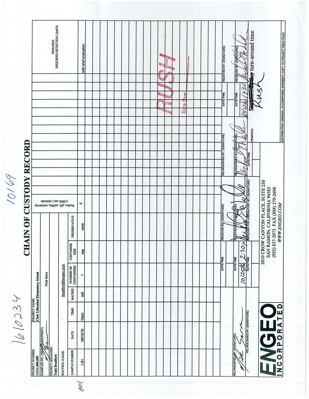
75
76 APPENDIX D Cone Penetration Testing A P P E N D I X D
77 Engeo Inc Project Claire Lilienthal School Operator JH-KK Filename SDF(058).cpt Job Number Cone Number DDG1333 GPS Hole Number 1CPT-01 Date and Time 9/10/2016 8:43:27 AM Maximum Depth ft EST GW Depth During Test ft Net Area Ratio.8 DEPTH (ft) 0 CPT DATA TIP FRICTION Fs/Qt SPT N 0 TSF TSF 18 0 % SOIL BEHAVIOR TYPE sensitive fine grained 4 - silty clay to clay 7 - silty sand to sandy silt 10 - gravelly sand to sand 2 - organic material 5 - clayey silt to silty clay 8 - sand to silty sand 11 - very stiff fine grained (*) 3 - clay 6 - sandy silt to clayey silt 9 - sand 12 - sand to clayey sand (*) Cone Size 10cm squared *Soil Behavior behavior Referance type and SPT based on data from UBC-1983
78 Engeo Inc Project Claire Lilienthal School Operator JH-KK Filename SDF(059).cpt Job Number Cone Number DDG1333 GPS Hole Number 1CPT-02 Date and Time 9/10/ :13:21 AM Maximum Depth ft EST GW Depth During Test 9.20 ft Net Area Ratio.8 DEPTH (ft) 0 CPT DATA TIP FRICTION Fs/Qt SPT N 0 TSF TSF 18 0 % SOIL BEHAVIOR TYPE sensitive fine grained 4 - silty clay to clay 7 - silty sand to sandy silt 10 - gravelly sand to sand 2 - organic material 5 - clayey silt to silty clay 8 - sand to silty sand 11 - very stiff fine grained (*) 3 - clay 6 - sandy silt to clayey silt 9 - sand 12 - sand to clayey sand (*) Cone Size 10cm squared *Soil Behavior behavior Referance type and SPT based on data from UBC-1983
79 Engeo Inc Project Claire Lilienthal School Operator JH-KK Filename SDF(060).cpt Job Number Cone Number DDG1333 GPS Hole Number 1CPT-03 Date and Time 9/10/ :14:16 PM Maximum Depth ft EST GW Depth During Test ft Net Area Ratio.8 DEPTH (ft) 0 CPT DATA TIP FRICTION Fs/Qt SPT N 0 TSF TSF 18 0 % SOIL BEHAVIOR TYPE sensitive fine grained 4 - silty clay to clay 7 - silty sand to sandy silt 10 - gravelly sand to sand 2 - organic material 5 - clayey silt to silty clay 8 - sand to silty sand 11 - very stiff fine grained (*) 3 - clay 6 - sandy silt to clayey silt 9 - sand 12 - sand to clayey sand (*) Cone Size 10cm squared *Soil Behavior behavior Referance type and SPT based on data from UBC-1983
80 Engeo Inc Project Claire Lilienthal School Operator JH-KK Filename SDF(061).cpt Job Number Cone Number DDG1333 GPS Hole Number 1CPT-04 Date and Time 9/10/2016 1:33:55 PM Maximum Depth ft EST GW Depth During Test 9.20 ft Net Area Ratio.8 DEPTH (ft) 0 CPT DATA TIP FRICTION Fs/Qt SPT N 0 TSF TSF 18 0 % SOIL BEHAVIOR TYPE sensitive fine grained 4 - silty clay to clay 7 - silty sand to sandy silt 10 - gravelly sand to sand 2 - organic material 5 - clayey silt to silty clay 8 - sand to silty sand 11 - very stiff fine grained (*) 3 - clay 6 - sandy silt to clayey silt 9 - sand 12 - sand to clayey sand (*) Cone Size 10cm squared *Soil Behavior behavior Referance type and SPT based on data from UBC-1983
81 APPENDIX E Previous Explorations A P P E N D I X E
82
83
84 APPENDIX F Liquefaction Analysis A P P E N D I X F
85 LIQUEFACTION ANALYSIS REPORT Project title : Claire Lilienthal Elementary School Location : San Francisco, California CPT file : 1-CPT1 Input parameters and analysis data Robertson (2009) Robertson (2009) Based on Ic value G.W.T. (in-situ): G.W.T. (earthq.): Average results interval: Ic cut-off value: Unit weight calculation: 5.00 ft 5.00 ft Based on SBT No Yes Yes Clay like behavior applied: Limit depth applied: Limit depth: MSF method: All soils No Method based Summary of liquefaction potential CLiq v CPT Liquefaction Assessment Software - Report created on: 5/23/2017, 3:37:57 PM Project file: G:\Active Projects\_12000 to 13999\13311\Exploration\1-CPT1 thru 1-CPT4 liquefaction no cyclic softening GWT 5 ft FS=1.3.clq 1
86 This software is licensed to: ENGEO Incorporated CPT name: 1-CPT1 CPT basic interpretation plots (normalized) Input parameters and analysis data Robertson (2009) Robertson (2009) Based on Ic value ft Depth to water table (erthq.): Average results interval: Ic cut-off value: Unit weight calculation: Use fill: Fill height: 5.00 ft Based on SBT No Yes Yes All soils No CLiq v CPT Liquefaction Assessment Software - Report created on: 5/23/2017, 3:37:57 PM Project file: G:\Active Projects\_12000 to 13999\13311\Exploration\1-CPT1 thru 1-CPT4 liquefaction no cyclic softening GWT 5 ft FS=1.3.clq SBTn legend 1. Sensitive fine grained 2. Organic material 4. Clayey silt to silty clay 5. Silty sand to sandy silt 3. Clay to silty clay 6. Clean sand to silty sand 7. Gravely sand to sand 8. Very stiff sand to clayey sand 9. Very stiff fine grained 2
87 This software is licensed to: ENGEO Incorporated CPT name: 1-CPT1 Liquefaction analysis overall plots F.S. color scheme Input parameters and analysis data Robertson (2009) Robertson (2009) Based on Ic value ft Depth to water table (erthq.): Average results interval: Ic cut-off value: Unit weight calculation: Use fill: Fill height: 5.00 ft Based on SBT No Yes Yes All soils No CLiq v CPT Liquefaction Assessment Software - Report created on: 5/23/2017, 3:37:57 PM Project file: G:\Active Projects\_12000 to 13999\13311\Exploration\1-CPT1 thru 1-CPT4 liquefaction no cyclic softening GWT 5 ft FS=1.3.clq LPI color scheme Almost certain it will liquefy Very high risk Very likely to liquefy High risk Liquefaction and no liq. are equally likely Low risk Unlike to liquefy Almost certain it will not liquefy 3
88 LIQUEFACTION ANALYSIS REPORT Project title : Claire Lilienthal Elementary School Location : San Francisco, California CPT file : 1-CPT2 Input parameters and analysis data Robertson (2009) Robertson (2009) Based on Ic value G.W.T. (in-situ): G.W.T. (earthq.): Average results interval: Ic cut-off value: Unit weight calculation: 5.00 ft 5.00 ft Based on SBT No Yes Yes Clay like behavior applied: Limit depth applied: Limit depth: MSF method: All soils No Method based Summary of liquefaction potential CLiq v CPT Liquefaction Assessment Software - Report created on: 5/23/2017, 3:37:58 PM Project file: G:\Active Projects\_12000 to 13999\13311\Exploration\1-CPT1 thru 1-CPT4 liquefaction no cyclic softening GWT 5 ft FS=1.3.clq 4
89 This software is licensed to: ENGEO Incorporated CPT name: 1-CPT2 CPT basic interpretation plots (normalized) Input parameters and analysis data Robertson (2009) Robertson (2009) Based on Ic value ft Depth to water table (erthq.): Average results interval: Ic cut-off value: Unit weight calculation: Use fill: Fill height: 5.00 ft Based on SBT No Yes Yes All soils No CLiq v CPT Liquefaction Assessment Software - Report created on: 5/23/2017, 3:37:58 PM Project file: G:\Active Projects\_12000 to 13999\13311\Exploration\1-CPT1 thru 1-CPT4 liquefaction no cyclic softening GWT 5 ft FS=1.3.clq SBTn legend 1. Sensitive fine grained 2. Organic material 4. Clayey silt to silty clay 5. Silty sand to sandy silt 3. Clay to silty clay 6. Clean sand to silty sand 7. Gravely sand to sand 8. Very stiff sand to clayey sand 9. Very stiff fine grained 5
90 This software is licensed to: ENGEO Incorporated Liquefaction analysis overall plots CPT name: 1-CPT2 Input parameters and analysis data Robertson (2009) Robertson (2009) Based on Ic value ft Depth to water table (erthq.): Average results interval: Ic cut-off value: Unit weight calculation: Use fill: Fill height: 5.00 ft Based on SBT No F.S. color scheme LPI color scheme Almost certain it will not liquefy CLiq v CPT Liquefaction Assessment Software - Report created on: 5/23/2017, 3:37:58 PM 6 Project file: G:\Active Projects\_12000 to 13999\13311\Exploration\1-CPT1 thru 1-CPT4 liquefaction no cyclic softening GWT 5 ft FS=1.3.clq Yes Yes All soils No Almost certain it will liquefy Very likely to liquefy Liquefaction and no liq. are equally likely Unlike to liquefy Very high risk High risk Low risk
91 LIQUEFACTION ANALYSIS REPORT Project title : Claire Lilienthal Elementary School Location : San Francisco, California CPT file : 1-CPT3 Input parameters and analysis data Robertson (2009) Robertson (2009) Based on Ic value G.W.T. (in-situ): G.W.T. (earthq.): Average results interval: Ic cut-off value: Unit weight calculation: 5.00 ft 5.00 ft Based on SBT No Yes Yes Clay like behavior applied: Limit depth applied: Limit depth: MSF method: All soils No Method based Summary of liquefaction potential CLiq v CPT Liquefaction Assessment Software - Report created on: 5/23/2017, 3:37:58 PM Project file: G:\Active Projects\_12000 to 13999\13311\Exploration\1-CPT1 thru 1-CPT4 liquefaction no cyclic softening GWT 5 ft FS=1.3.clq 7
92 This software is licensed to: ENGEO Incorporated CPT name: 1-CPT3 CPT basic interpretation plots (normalized) Input parameters and analysis data Robertson (2009) Robertson (2009) Based on Ic value ft Depth to water table (erthq.): Average results interval: Ic cut-off value: Unit weight calculation: Use fill: Fill height: 5.00 ft Based on SBT No Yes Yes All soils No CLiq v CPT Liquefaction Assessment Software - Report created on: 5/23/2017, 3:37:58 PM Project file: G:\Active Projects\_12000 to 13999\13311\Exploration\1-CPT1 thru 1-CPT4 liquefaction no cyclic softening GWT 5 ft FS=1.3.clq SBTn legend 1. Sensitive fine grained 2. Organic material 4. Clayey silt to silty clay 5. Silty sand to sandy silt 3. Clay to silty clay 6. Clean sand to silty sand 7. Gravely sand to sand 8. Very stiff sand to clayey sand 9. Very stiff fine grained 8
93 This software is licensed to: ENGEO Incorporated CPT name: 1-CPT3 Liquefaction analysis overall plots F.S. color scheme Input parameters and analysis data Robertson (2009) Robertson (2009) Based on Ic value ft Depth to water table (erthq.): Average results interval: Ic cut-off value: Unit weight calculation: Use fill: Fill height: 5.00 ft Based on SBT No Yes Yes All soils No CLiq v CPT Liquefaction Assessment Software - Report created on: 5/23/2017, 3:37:58 PM Project file: G:\Active Projects\_12000 to 13999\13311\Exploration\1-CPT1 thru 1-CPT4 liquefaction no cyclic softening GWT 5 ft FS=1.3.clq LPI color scheme Almost certain it will liquefy Very high risk Very likely to liquefy High risk Liquefaction and no liq. are equally likely Low risk Unlike to liquefy Almost certain it will not liquefy 9
 Robertson (2009) Based on Ic value 8.10 0.58. G.W.T. (in-situ): G.")


94 LIQUEFACTION ANALYSIS REPORT Project title : Claire Lilienthal Elementary School Location : San Francisco, California CPT file : 1-CPT4 Input parameters and analysis data Robertson (2009) Robertson (2009) Based on Ic value G.W.T. (in-situ): G.W.T. (earthq.): Average results interval: Ic cut-off value: Unit weight calculation: 5.00 ft 5.00 ft Based on SBT No Yes Yes Clay like behavior applied: Limit depth applied: Limit depth: MSF method: All soils No Method based Summary of liquefaction potential CLiq v CPT Liquefaction Assessment Software - Report created on: 5/23/2017, 3:37:59 PM Project file: G:\Active Projects\_12000 to 13999\13311\Exploration\1-CPT1 thru 1-CPT4 liquefaction no cyclic softening GWT 5 ft FS=1.3.clq 10
95 This software is licensed to: ENGEO Incorporated CPT basic interpretation plots (normalized) CPT name: 1-CPT4 Input parameters and analysis data Robertson (2009) Robertson (2009) Based on Ic value ft Depth to water table (erthq.): Average results interval: Ic cut-off value: Unit weight calculation: Use fill: Fill height: 5.00 ft Based on SBT No SBTn legend 1. Sensitive fine grained 2. Organic material 3. Clay to silty clay 4. Clayey silt to silty clay 5. Silty sand to sandy silt 6. Clean sand to silty sand 7. Gravely sand to sand 8. Very stiff sand to clayey sand 9. Very stiff fine grained CLiq v CPT Liquefaction Assessment Software - Report created on: 5/23/2017, 3:37:59 PM 11 Project file: G:\Active Projects\_12000 to 13999\13311\Exploration\1-CPT1 thru 1-CPT4 liquefaction no cyclic softening GWT 5 ft FS=1.3.clq Yes Yes All soils No
: Average results interval: Ic cut-off value: Unit weight calculation: Use fill: Fill height: 5.00 ft 3 2.60 Based on SB")
96 This software is licensed to: ENGEO Incorporated Liquefaction analysis overall plots CPT name: 1-CPT4 Input parameters and analysis data Robertson (2009) Robertson (2009) Based on Ic value ft Depth to water table (erthq.): Average results interval: Ic cut-off value: Unit weight calculation: Use fill: Fill height: 5.00 ft Based on SBT No F.S. color scheme LPI color scheme Almost certain it will not liquefy CLiq v CPT Liquefaction Assessment Software - Report created on: 5/23/2017, 3:37:59 PM 12 Project file: G:\Active Projects\_12000 to 13999\13311\Exploration\1-CPT1 thru 1-CPT4 liquefaction no cyclic softening GWT 5 ft FS=1.3.clq Yes Yes All soils No Almost certain it will liquefy Very likely to liquefy Liquefaction and no liq. are equally likely Unlike to liquefy Very high risk High risk Low risk
Date: April 2, 2014 Project No.: Prepared For: Mr. Adam Kates CLASSIC COMMUNITIES 1068 E. Meadow Circle Palo Alto, California 94303
 City of Newark - 36120 Ruschin Drive Project Draft Initial Study/Mitigated Negative Declaration Appendix C: Geologic Information FirstCarbon Solutions H:\Client (PN-JN)\4554\45540001\ISMND\45540001 36120
(THIS IS ONLY A SAMPLE REPORT OR APPENDIX OFFERED TO THE USERS OF THE COMPUTER PROGRAM
 C A U T I O N!! (THIS IS ONLY A SAMPLE REPORT OR APPENDIX OFFERED TO THE USERS OF THE COMPUTER PROGRAM EQLique&Settle2. THE AUTHOR IS HEREBY RELEASED OF ANY LIABILITY FOR ANY INCORRECT USE OF THIS SAMPLE
Mitigation of Liquefaction Potential Using Rammed Aggregate Piers
 ASCE 2011 557 Mitigation of Liquefaction Potential Using Rammed Aggregate Piers R.W. Rudolph, M. ASCE, G.E. 1, B. Serna, M. ASCE, P.E. 2, and T. Farrell, M. ASCE, G.E. 3 1 Principal Consultant, ENGEO,
Evaluation of soil liquefaction using the CPT Part 1
 Evaluation of soil liquefaction using the CPT Part 1 Dr. Peter K. Robertson Webinar #7 2013 CPT Guide 5 th Edition Download FREE copy from: Robertson & Cabal (Robertson) 5 th Edition 2012 www.greggdrilling.com
Should you have any questions regarding this clarification, please contact the undersigned at or (925)
") October 8, 2015 Revised October 13, 2015 Contra Costa Community College District 500 Court Street Martinez, CA 94553 Attention: Ron Johnson Subject: Clarification of Grading Requirements Diablo Valley
October 8, 2015 Revised October 13, 2015 Contra Costa Community College District 500 Court Street Martinez, CA 94553 Attention: Ron Johnson Subject: Clarification of Grading Requirements Diablo Valley
Roy Pyle March 24, 2017 Chief Facilities Planner Contra Costa Community College District 500 North Court Street Martinez, CA 94533
 State of California Natural Resources Agency Edmund G. Brown Jr., Governor Department of Conservation John G. Parrish, Ph.D., State Geologist California Geological Survey 801 K Street MS 12-31 Sacramento,
IV. ENVIRONMENTAL IMPACT ANALYSIS G. GEOLOGY AND SOILS
 IV. ENVIRONMENTAL IMPACT ANALYSIS G. GEOLOGY AND SOILS The following section is a summary of the geotechnical report conducted for the proposed project. The Report of Geotechnical Investigation Proposed
Liquefaction induced ground damage in the Canterbury earthquakes: predictions vs. reality
 Bowen, H. J. & Jacka, M. E. () Proc. th NZGS Geotechnical Symposium. Ed. CY Chin, Queenstown Liquefaction induced ground damage in the Canterbury earthquakes: predictions vs. reality H J Bowen & M E Jacka
Impact : Changes to Existing Topography (Less than Significant)
") 4.2 Land Resources 4.2.1 Alternative A Proposed Action Impact 4.2.1-1: Changes to Existing Topography (Less than Significant) Development of the project site would involve grading and other earthwork as
4.2 Land Resources 4.2.1 Alternative A Proposed Action Impact 4.2.1-1: Changes to Existing Topography (Less than Significant) Development of the project site would involve grading and other earthwork as
DATA REPORT GEOTECHNICAL INVESTIGATION GALVESTON CRUISE TERMINAL 2 GALVESTON, TEXAS
 DATA REPORT GEOTECHNICAL INVESTIGATION GALVESTON CRUISE TERMINAL 2 GALVESTON, TEXAS SUBMITTED TO PORT OF GALVESTON 123 ROSENBERG AVENUE, 8TH FLOOR GALVESTON, TEXAS 77553 BY HVJ ASSOCIATES, INC. HOUSTON,
Use of CPT in Geotechnical Earthquake Engineering
 Use of CPT in Geotechnical Earthquake Engineering Prof. Scott M. Olson, PhD, PE Use of Cone Penetration Test for Foundation Analysis and Design 2006 Annual Meeting Transportation Research Board Geotechnical
Performance and Post Earthquake Assessment of CFA Pile Ground Improvement 22 February 2011 Christchurch, New Zealand Earthquake
 Performance and Post Earthquake Assessment of CFA Pile Ground Improvement 22 February 2011 Christchurch, New Zealand Earthquake K. M. Murahidy, S. W Sutherland & M. E. Jacka Tonkin & Taylor Ltd, Christchurch,
Pierce County Department of Planning and Land Services Development Engineering Section
 Page 1 of 7 Pierce County Department of Planning and Land Services Development Engineering Section PROJECT NAME: DATE: APPLICATION NO.: PCDE NO.: LANDSLIDE HAZARD AREA (LHA) GEOLOGICAL ASSESSMENT REPORT
 R-1 Conveyor Relocation Project Legend 0 500 1000 1500 ft. This map is a user generated static output from an Internet mapping site and is for general reference only. Data layers that appear on this map
September 7, 2017 (Revised November 1, 2017)
") September 7, 2017 (Revised November 1, 2017) Project No. 10113.002 Environmental Advisors 2400 East Katella Avenue, Suite 800 Anaheim, California 92806 Attention: Subject: Mr. Greg McCafferty Response
September 7, 2017 (Revised November 1, 2017) Project No. 10113.002 Environmental Advisors 2400 East Katella Avenue, Suite 800 Anaheim, California 92806 Attention: Subject: Mr. Greg McCafferty Response
Evaluation of soil liquefaction using the CPT Part 2
 Evaluation of soil liquefaction using the CPT Part 2 P.K. Robertson 2013 Definitions of Liquefaction Cyclic (seismic) Liquefaction Zero effective stress (during cyclic loading) Flow (static) Liquefaction
GEOLOGY AND SOILS. This chapter summarizes geologic and geotechnical aspects of the site as they relate to the Project.
 9 GEOLOGY AND SOILS INTRODUCTION This chapter summarizes geologic and geotechnical aspects of the site as they relate to the Project. This chapter utilizes information from the following reports prepared
Converse Consultants Geotechnical Engineering, Environmental & Groundwater Science, Inspection & Testing Services
 Converse Consultants Geotechnical Engineering, Environmental & Groundwater Science, Inspection & Testing Services Ms. Rebecca Mitchell Mt. San Antonio College Facilities Planning & Management 1100 North
Important Concepts. Earthquake hazards can be categorized as:
 Lecture 1 Page 1 Important Concepts Monday, August 17, 2009 1:05 PM Earthquake Engineering is a branch of Civil Engineering that requires expertise in geology, seismology, civil engineering and risk assessment.
CPT Applications - Liquefaction 2
 CPT Applications - Liquefaction 2 Peter K. Robertson CPT in Geotechnical Practice Santiago, Chile July, 2014 Definitions of Liquefaction Cyclic (seismic) Liquefaction Zero effective stress (during cyclic
SOME OBSERVATIONS RELATED TO LIQUEFACTION SUSCEPTIBILITY OF SILTY SOILS
 SOME OBSERVATIONS RELATED TO LIQUEFACTION SUSCEPTIBILITY OF SILTY SOILS Upul ATUKORALA 1, Dharma WIJEWICKREME 2 And Norman MCCAMMON 3 SUMMARY The liquefaction susceptibility of silty soils has not received
IV. ENVIRONMENTAL IMPACT ANALYSIS E. GEOLOGY AND SOILS
 IV. ENVIRONMENTAL IMPACT ANALYSIS E. GEOLOGY AND SOILS The following section is a summary of the geotechnical report conducted for the Proposed Project. The Geotechnical Engineering Investigation (the
FRIENDS OF THE EEL RIVER
 FRIENDS OF THE EEL RIVER Working for the recovery of our Wild & Scenic River, its fisheries and communities. Frank Blackett, Regional Engineer Office of Energy Projects Division of Dam Safety and Inspections
Cone Penetration Testing in Geotechnical Practice
 Cone Penetration Testing in Geotechnical Practice Table Of Contents: LIST OF CONTENTS v (4) PREFACE ix (2) ACKNOWLEDGEMENTS xi (1) SYMBOL LIST xii (4) CONVERSION FACTORS xvi (6) GLOSSARY xxii 1. INTRODUCTION
Case History of Observed Liquefaction-Induced Settlement Versus Predicted Settlement
 Case History of Observed Liquefaction-Induced Settlement Versus Predicted Settlement M. Lew and L. Tran AMEC Environment & Infrastructure, Inc., Los Angeles, CA USA SUMMARY: A comparison of the predicted
LSN a new methodology for characterising the effects of liquefaction in terms of relative land damage severity
 van Ballegooy, S., Lacrosse, V., Jacka, M. & Malan, P. (2013) Proc. 19 th NZGS Geotechnical Symposium. Ed. CY Chin, Queenstown LSN a new methodology for characterising the effects of liquefaction in terms
14 Geotechnical Hazards
 Volume 2: Assessment of Environmental Effects 296 14 Geotechnical Hazards Overview This Chapter provides an assessment of the underlying geotechnical conditions to identify: any potential liquefaction
SLOPE STABILITY EVALUATION AND ACCEPTANCE STANDARDS
 INFORMATION BULLETIN / PUBLIC - BUILDING CODE REFERENCE NO.: LABC 7006.3, 7014.1 Effective: 01-01-2017 DOCUMENT NO.: P/BC 2017-049 Revised: 12-21-2016 Previously Issued As: P/BC 2014-049 SLOPE STABILITY
Chapter 12 Subsurface Exploration
 Page 12 1 Chapter 12 Subsurface Exploration 1. The process of identifying the layers of deposits that underlie a proposed structure and their physical characteristics is generally referred to as (a) subsurface
GEOLOGY, SOILS, AND SEISMICITY
 4.9 GEOLOGY, SOILS, AND SEISMICITY 4.9.1 Introduction Information about the geological conditions and seismic hazards in the study area was summarized in the FEIR, and was based on the Geotechnical Exploration
CPT: Geopractica Contracting (Pty) Ltd Total depth: m, Date:
 Ltd Total depth: m, Date:") The plot below presents the cross correlation coeficient between the raw qc and fs values (as measured on the field). X axes presents the lag distance (one lag is the distance between two sucessive CPT
The plot below presents the cross correlation coeficient between the raw qc and fs values (as measured on the field). X axes presents the lag distance (one lag is the distance between two sucessive CPT
Liquefaction and Foundations
 Liquefaction and Foundations Amit Prashant Indian Institute of Technology Gandhinagar Short Course on Seismic Design of Reinforced Concrete Buildings 26 30 November, 2012 What is Liquefaction? Liquefaction
December 5, Junction Gateway, LLC 7551 W. Sunset Boulevard #203 Los Angeles, CA Mr. James Frost P: Dear Mr.
 December 5, 2014 Junction Gateway, LLC 7551 W. Sunset Boulevard #203 90046 Attn: Re: Mr. James Frost P: 323.883.1800 Geotechnical Update Letter Sunset & Effie Mixed Use Development 4301 to 4311 Sunset
Comparison between predicted liquefaction induced settlement and ground damage observed from the Canterbury earthquake sequence
 Power, P.M. & Jacka, M. (2013) the Canterbury earthquake sequence Proc. 19 th NZGS Geotechnical Symposium. Ed. CY Chin, Queenstown Comparison between predicted liquefaction induced settlement and ground
EARTHQUAKE-INDUCED SETTLEMENTS IN SATURATED SANDY SOILS
 VOL., NO., AUGUST 7 ISSN 119- -7 Asian Research Publishing Network (ARPN). All rights reserved. EARTHQUAKE-INDUCED SETTLEMENTS IN SATURATED SANDY SOILS C. Y. Lee Department of Civil Engineering, College
SITE INVESTIGATION 1
 SITE INVESTIGATION 1 Definition The process of determining the layers of natural soil deposits that will underlie a proposed structure and their physical properties is generally referred to as site investigation.
Assessing effects of Liquefaction. Peter K. Robertson 2016
 Assessing effects of Liquefaction Peter K. Robertson 2016 1964 1995 2010 Flow (static) Liquefaction After Olson & Stark, 2003 Case histories flow liquefaction Common soil features: Very young age Non-plastic
Evaluation of Geotechnical Hazards
 Evaluation of Geotechnical Hazards by Geoffrey R. Martin Appendix B: Evaluation of Geotechnical Hazards Describes Evaluation Procedures Soil Liquefaction Soil Settlement Surface Fault Rupture Flooding
Soil Behaviour Type from the CPT: an update
 Soil Behaviour Type from the CPT: an update P.K. Robertson Gregg Drilling & Testing Inc., Signal Hill, California, USA ABSTRACT: One of the most common applications of CPT results is to evaluate soil type
patersongroup Consulting Engineers April 20, 2010 File: PG1887-LET.01R Novatech Engineering Consultants Suite 200, 240 Michael Cowpland Drive
 patersongroup April 20, 2010 File: PG1887-LET.01R Novatech Engineering Consultants Suite 200, 240 Michael Cowpland Drive Ottawa, Ontario K2M 1P6 Attention: Mr. Adam Thompson Consulting Engineers 28 Concourse
Module 6 LIQUEFACTION (Lectures 27 to 32)
") Module 6 LIQUEFACTION (Lectures 27 to 32) Lecture 31 Topics 6.6 EFFECTS OF LIQUEFACTION 6.6.1 Alteration of Ground Motion 6.6.2 Development of Sand Boils 6.6.3 Settlement 6.6.4 Settlement of Dry Sands
Module 6 LIQUEFACTION (Lectures 27 to 32) Lecture 31 Topics 6.6 EFFECTS OF LIQUEFACTION 6.6.1 Alteration of Ground Motion 6.6.2 Development of Sand Boils 6.6.3 Settlement 6.6.4 Settlement of Dry Sands
IV. ENVIRONMENTAL IMPACT ANALYSIS E. GEOLOGY/SOILS
 IV. ENVIRONMENTAL IMPACT ANALYSIS E. GEOLOGY/SOILS Except where otherwise noted, the following Section is based on the Preliminary Geotechnical Investigation, Proposed Medical Office Buildings and Mixed-Use
IAEA SAFETY STANDARDS Geotechnical Aspects of Site Evaluation and Foundations in NPPs, NS-G-3.6
 IAEA SAFETY STANDARDS Geotechnical Aspects of Site Evaluation and Foundations in NPPs, NS-G-3.6 Regional Workshop on Volcanic, Seismic, and Tsunami Hazard Assessment Related to NPP Siting Activities and
The LSN Calculation and Interpolation Process
 Appendix I : The LSN Calculation and Interpolation Process I1. Introduction Cone Penetration Tests (CPTs) can be used in the assessment of the liquefaction vulnerability. The CPTs available from the Canterbury
COMMUNITY DEVELOPMENT DEPARTMENT POLICY & PROCEDURE
 COMMUNITY DEVELOPMENT DEPARTMENT POLICY & PROCEDURE Policy No: DSP-OO3 Release Date: January 1, 2014 Effective Date: January 1, 2014 Revision Date: March 1, 2018 TITLE: The City Policy for Site Specific
DRILLED DISPLACMENT PILE PERFORMANCE IN COASTAL PLAIN AND RESIDUAL SOILS
 DRILLED DISPLACMENT PILE PERFORMANCE IN COASTAL PLAIN AND RESIDUAL SOILS Presented by: W. Morgan NeSmith, P.E. Berkel & Company Contractors Inc. 770.941.5100 mnesmith@berkelapg.com SC Engineering Conference
Guidelines for Site-Specific Seismic Hazard Reports for Essential and Hazardous Facilities and Major and Special-Occupancy Structures in Oregon
 Guidelines for Site-Specific Seismic Hazard Reports for Essential and Hazardous Facilities and Major and Special-Occupancy Structures in Oregon By the Oregon Board of Geologist Examiners and the Oregon
GUIDANCE D. Part D: Guidelines for the geotechnical investigation and assessment of subdivisions in the Canterbury region.
 GUIDANCE D CONTENTS Part D: Guidelines for the geotechnical investigation and assessment of subdivisions in the Canterbury region Minimum requirements for geotechnical assessment for land development (
SLOPE STABILITY EVALUATION AND ACCEPTANCE STANDARDS
 INFORMATION BULLETIN / PUBLIC - BUILDING CODE REFERENCE NO.: LAMC 98.0508 Effective: 1-26-84 DOCUMENT NO. P/BC 2002-049 Revised: 11-1-02 Previously Issued As: RGA #1-84 SLOPE STABILITY EVALUATION AND ACCEPTANCE
Limited Geotechnical Engineering Evaluation Classroom Additions Albany County Campus Laramie, Wyoming
 Limited Geotechnical Engineering Evaluation Classroom Additions Albany County Campus 2300 Missile Drive, Cheyenne, Wyoming 82001 Phone 307-635-0222 www.stratageotech.com Limited Geotechnical Engineering
GEOTECHNICAL EXPLORATION REPORT ROPOSED COMMERCIAL/RETAIL DEVELOPMENT 7967, & 8015 BEVERLY BOULEVARD
 ADDENDUM TO GEOTECHNICAL EXPLORATION REPORT PROPOSED COMMERCIAL/RETAIL DEVELOPMENT 7967, 8001-8011 & 8015 BEVERLY BOULEVARD CITY OF LOS ANGELES, CALIFORNIA Prepared for: OPT Beverly, LLC 6400 South Fiddlers
Numerical analysis of effect of mitigation measures on seismic performance of a liquefiable tailings dam foundation
 Numerical analysis of effect of mitigation measures on seismic performance of a liquefiable tailings dam foundation Yong-Beom Lee, Jorge Castillo Ausenco, USA Aurelian C. Trandafir Fugro GeoConsulting
ATTACHMENT A PRELIMINARY GEOTECHNICAL SUMMARY
 ATTACHMENT A PRELIMINARY GEOTECHNICAL SUMMARY Kevin M. Martin, P.E. KMM Geotechnical Consultants, LLC 7 Marshall Road Hampstead, NH 0384 603-489-6 (p)/ 603-489-8 (f)/78-78-4084(m) kevinmartinpe@aol.com
B-1 BORE LOCATION PLAN. EXHIBIT Drawn By: 115G BROOKS VETERINARY CLINIC CITY BASE LANDING AND GOLIAD ROAD SAN ANTONIO, TEXAS.
 N B-1 SYMBOLS: Exploratory Boring Location Project Mngr: BORE LOCATION PLAN Project No. GK EXHIBIT Drawn By: 115G1063.02 GK Scale: Checked By: 1045 Central Parkway North, Suite 103 San Antonio, Texas 78232
Performance based earthquake design using the CPT
 Performance based earthquake design using the CPT P.K. Robertson Gregg Drilling & Testing Inc., Signal Hill, California, USA Performance-Based Design in Earthquake Geotechnical Engineering Kokusho, Tsukamoto
APPENDIX F CORRELATION EQUATIONS. F 1 In-Situ Tests
 APPENDIX F 1 APPENDIX F CORRELATION EQUATIONS F 1 In-Situ Tests 1. SPT (1) Sand (Hatanaka and Uchida, 1996), = effective vertical stress = effective friction angle = atmosphere pressure (Shmertmann, 1975)
Preliminary Geotechnical Evaluation Gooseberry Point Pedestrian Improvements Whatcom County, Washington SITE AND PROJECT DESCRIPTION
 File No. 12-100 Geotechnical & Earthquake Engineering Consultants Mr. Kevin Brown, P.E. Gray & Osborne, Inc. 3710 168 th Street NE, Suite B210 Arlington, Washington 98223 Subject: Draft Report Preliminary
June 9, R. D. Cook, P.Eng. Soils Engineer Special Services Western Region PUBLIC WORKS CANADA WESTERN REGION REPORT ON
 PUBLIC WORKS CANADA WESTERN REGION REPORT ON GEOTECHNICAL INVESTIGATION PROPOSED MARTIN RIVER BRIDGE MILE 306.7 MACKENZIE HIGHWAY Submitted by : R. D. Cook, P.Eng. Soils Engineer Special Services Western
 Photo 1 - Southerly view across 2700 parking lot toward existing building. Multi-residential building borders western side of property in upper right of view. Photo 2 - Southerly view across 2750 parking
Evaluating Soil Liquefaction and Post-earthquake deformations using the CPT
 Evaluating Soil Liquefaction and Post-earthquake deformations using the CPT P.K. Robertson University of Alberta, Dept. of Civil and Environmental Engineering, Edmonton, Canada Keywords: Soil liquefaction,
Case Study - Undisturbed Sampling, Cyclic Testing and Numerical Modelling of a Low Plasticity Silt
 6 th International Conference on Earthquake Geotechnical Engineering 1-4 November 2015 Christchurch, New Zealand Case Study - Undisturbed Sampling, Cyclic Testing and Numerical Modelling of a Low Plasticity
Setting MOUNTAIN HOUSE NEIGHBORHOODS I AND J INITIAL STUDY 5. ENVIRONMENTAL CHECKLIST 6. GEOLOGY AND SOILS. Issue
 Issue Less Than Significant or No Impact Potential Significant Impact Adequately Addressed in MEIR MEIR Required Additional Review: No Significant Impact Less Than Significant Impact Due to Mitigation
3.0 SUMMARY OF POTENTIAL GEOTECHNICAL IMPACTS AND MITIGATION MEASURES
 3.0 SUMMARY OF POTENTIAL GEOTECHNICAL IMPACTS AND MITIGATION MEASURES This section summarizes the principal geotechnical conditions that occur in the project area. The potential impact that each condition
Geotechnical issues in seismic assessments: When do I need a geotechnical specialist?
 Geotechnical issues in seismic assessments: When do I need a geotechnical specialist? B.H. Rama & S.J. Palmer Tonkin & Taylor Ltd (T+T), Wellington, New Zealand. 2016 NZSEE Conference ABSTRACT: The Canterbury
3.4 Typical Soil Profiles
 SEI.UoC.0002.11 Figure 4. Streams in central Christchurch as mapped in March 1850, superposed on aerial photography captured on 24 February 2011. Streams digitised from the Black Map of Christchurch (March
Civil Engineering, Surveying and Environmental Consulting WASP0059.ltr.JLS.Mich Ave Bridge Geotech.docx
 2365 Haggerty Road South * Canton, Michigan 48188 P: 734-397-3100 * F: 734-397-3131 * www.manniksmithgroup.com August 29, 2012 Mr. Richard Kent Washtenaw County Parks and Recreation Commission 2330 Platt
J. Paul Guyer, P.E., R.A.
 J. Paul Guyer, P.E., R.A. Paul Guyer is a registered mechanical engineer, civil engineer, fire protection engineer and architect with over 35 years experience in the design of buildings and related infrastructure.
Geotechnical Engineering Study, Conifer Senior High School Football Field Improvements, Conifer, Colorado
 2390 South Lipan Street Denver, CO 80223 phone: (303) 742-9700 fax: (303) 742-9666 email: kadenver@kumarusa.com www.kumarusa.com Office Locations: Denver (HQ), Colorado Springs, Fort Collins, and Frisco,
(C) Global Journal of Engineering Science and Research Management
 Global Journal of Engineering Science and Research Management") GEOTECHNCIAL ASSESSMENT OF PART OF PORT HARCOURT, NIGER DELTA FOR STRUCTURAL ANALYSIS Warmate Tamunonengiyeofori Geostrat International Services Limited, www.geostratinternational.com. *Correspondence
GEOTECHNCIAL ASSESSMENT OF PART OF PORT HARCOURT, NIGER DELTA FOR STRUCTURAL ANALYSIS Warmate Tamunonengiyeofori Geostrat International Services Limited, www.geostratinternational.com. *Correspondence
Rosemerryn Subdivision, Lincoln Stages 10 to 18 Geotechnical Investigation Report Fulton Hogan Land Development Limited
 This information Memorandum, title or other supplementary property information (the Information ) has been prepared by Whalan and Partners Limited, trading as Bayleys ( Bayleys ) as agent for the Vendor.
 PRELIMINARY GEOTECHNICAL EXPLORATION Additional MeadWestvaco Ridgeville Property 331 acres Dorchester County, South Carolina S&ME Project No. 1131-09-259A Prepared For: BP Barber & Associates Post Office
Class Principles of Foundation Engineering CEE430/530
 Class Principles of Foundation Engineering CEE430/530 1-1 General Information Lecturer: Scott A. Barnhill, P.E. Lecture Time: Thursday, 7:10 pm to 9:50 pm Classroom: Kaufmann, Room 224 Office Hour: I have
Investigation of Liquefaction Behaviour for Cohesive Soils
 Proceedings of the 3 rd World Congress on Civil, Structural, and Environmental Engineering (CSEE 18) Budapest, Hungary April 8-10, 2018 Paper No. ICGRE 134 DOI: 10.11159/icgre18.134 Investigation of Liquefaction
GEOTECHNICAL SEISMIC HAZARDS
 Chapter 13 GEOTECHNICAL SEISMIC HAZARDS FINAL SCDOT GEOTECHNICAL DESIGN MANUAL June 2010 Table of Contents Section Page 13.1 Introduction... 13-1 13.2 Geotechnical Seismic Hazard Failure Modes... 13-2
CEMEX Eliot Quarry. Lake A Evaluation Report. Alameda County, California
 May 7, 2015 May 7, 2015 Project No. GT13-16 Prepared for: CEMEX 5180 Golden Foothills, Parkway El Dorado Hills, California 95762 7400 Shoreline Drive, Ste. 6 Stockton, California 95219 Tel: 209-472-1822
Pile Drag Load and Downdrag in a Liquefaction Event
 San Francisco 196 Fellenius, B.H. and Siegel, T.C, 7 Pile design consideration in a liquefaction event. ASCE Journal of Geotechnical and Environmental Engineering, 132(9) 1412-1416. Pile Drag Load and
DRAFT. Proposed 303 Baldwin Avenue Retail, Office, and Residential Building Prelim
 Type of Services Project Name Location Client Geotechnical Preliminary Investigation Proposed 303 Baldwin Avenue Retail, Office, and Residential Building Prelim 303 Baldwin Avenue San Mateo, California
Field Exploration. March 31, J-U-B ENGINEERS, Inc. 115 Northstar Avenue Twin Falls, Idaho Attn: Mr. Tracy Ahrens, P. E. E:
 March 31, 201 11 Northstar Avenue 83301 Attn: Mr. Tracy Ahrens, P. E. E: taa@jub.com Re: Geotechnical Data Report Preliminary Phase 1 Field Exploration Revision No. 1 Proposed Rapid Infiltration Basin
ENGINEER S CERTIFICATION OF FAULT AREA DEMONSTRATION (40 CFR )
") PLATTE RIVER POWER AUTHORITY RAWHIDE ENERGY STATION BOTTOM ASH TRANSFER (BAT) IMPOUNDMENTS LARIMER COUNTY, CO ENGINEER S CERTIFICATION OF FAULT AREA DEMONSTRATION (40 CFR 257.62) FOR COAL COMBUSTION RESIDUALS
PLATTE RIVER POWER AUTHORITY RAWHIDE ENERGY STATION BOTTOM ASH TRANSFER (BAT) IMPOUNDMENTS LARIMER COUNTY, CO ENGINEER S CERTIFICATION OF FAULT AREA DEMONSTRATION (40 CFR 257.62) FOR COAL COMBUSTION RESIDUALS
ENCE 3610 Soil Mechanics. Site Exploration and Characterisation Field Exploration Methods
 ENCE 3610 Soil Mechanics Site Exploration and Characterisation Field Exploration Methods Geotechnical Involvement in Project Phases Planning Design Alternatives Preparation of Detailed Plans Final Design
Minnesota Department of Transportation Geotechnical Section Cone Penetration Test Index Sheet 1.0 (CPT 1.0)
") This Cone Penetration Test (CPT) Sounding follows ASTM D 778 and was made by ordinary and conventional methods and with care deemed adequate for the Department's design purposes. Since this sounding was
This Cone Penetration Test (CPT) Sounding follows ASTM D 778 and was made by ordinary and conventional methods and with care deemed adequate for the Department's design purposes. Since this sounding was
SUMMARY OF SOIL CONDITIONS CITYWIDE SIDEWALK IMPROVEMENT PROJECT JIMMY DURANTE BOULEVARD, VIA DE LA VALLE, AND CAMINO DEL MAR DEL MAR, CALIFORNIA
 SUMMARY OF SOIL CONDITIONS CITYWIDE SIDEWALK IMPROVEMENT PROJECT JIMMY DURANTE BOULEVARD, VIA DE LA VALLE, AND CAMINO DEL MAR DEL MAR, CALIFORNIA PREPARED FOR NASLAND ENGINEERING SAN DIEGO, CALIFORNIA
Liquefaction potential of Rotorua soils
 Pearse-Danker, E. (2013) Liquefaction potential of Rotorua soils Proc. 19 th NZGS Geotechnical Symposium. Ed. CY Chin, Queenstown Liquefaction potential of Rotorua soils E Pearse-Danker Coffey Geotechnics
KDOT Geotechnical Manual Edition. Table of Contents
 KDOT Geotechnical Manual 2007 Edition The KDOT Geotechnical Manual is available two volumes. Both volumes are very large electronic (pdf) files which may take several minutes to download. The table of
Minnesota Department of Transportation Geotechnical Section Cone Penetration Test Index Sheet 1.0 (CPT 1.0)
") This Cone Penetration Test (CPT) Sounding follows ASTM D 5778 and was made by ordinary and conventional methods and with care deemed adequate for the Department's design purposes. Since this sounding was
This Cone Penetration Test (CPT) Sounding follows ASTM D 5778 and was made by ordinary and conventional methods and with care deemed adequate for the Department's design purposes. Since this sounding was
IV. ENVIRONMENTAL IMPACT ANALYSIS E. GEOLOGY AND SOILS
 IV. ENVIRONMENTAL IMPACT ANALYSIS E. GEOLOGY AND SOILS The following analysis is based on the Geotechnical Investigation Report, Proposed Mid-Rise Multi- Family Residential Development Project Wetherly
Slope Stability Evaluation Ground Anchor Construction Area White Point Landslide San Pedro District Los Angeles, California.
 Slope Stability Evaluation Ground Anchor Construction Area White Point Landslide San Pedro District Los Angeles, California Submitted To: Mr. Gene Edwards City of Los Angeles Department of Public Works
LIQUEFACTION OF EARTH EMBANKMENT DAMS TWO CASE HISTORIES: (1) LIQUEFACTION OF THE EMBANKMENT SOILS, AND (2) LIQUEFACTION OF THE FOUNDATIONS SOILS
 LIQUEFACTION OF THE EMBANKMENT SOILS, AND (2) LIQUEFACTION OF THE FOUNDATIONS SOILS") LIQUEFACTION OF EARTH EMBANKMENT DAMS TWO CASE HISTORIES: (1) LIQUEFACTION OF THE EMBANKMENT SOILS, AND (2) LIQUEFACTION OF THE FOUNDATIONS SOILS Antonio Fernandez, Ph.D. 1 ABSTRACT Paul C. Rizzo Associates,
LIQUEFACTION OF EARTH EMBANKMENT DAMS TWO CASE HISTORIES: (1) LIQUEFACTION OF THE EMBANKMENT SOILS, AND (2) LIQUEFACTION OF THE FOUNDATIONS SOILS Antonio Fernandez, Ph.D. 1 ABSTRACT Paul C. Rizzo Associates,
Christchurch CBD: Lessons Learnt and Strategies for Foundation Remediation 22 February 2011 Christchurch, New Zealand, Earthquake
 Christchurch CBD: Lessons Learnt and Strategies for Foundation Remediation 22 February 2011 Christchurch, New Zealand, Earthquake K.M. Murahidy & A.F. Sleight Tonkin & Taylor Ltd, Christchurch, New Zealand
Hawke s Bay Liquefaction Hazard Report - Frequently Asked Questions
 Hawke s Bay Liquefaction Hazard Report - Frequently Asked Questions What is liquefaction? Liquefaction occurs when an earthquake shakes up water-logged sediments. As a result, the soil behaves like a liquid
IN SITU TESTING TECHNOLOGY FOR FOUNDATION & EARTHQUAKE ENGINEERING. Wesley Spang, Ph.D., P.E. AGRA Earth & Environmental, Inc.
 IN SITU TESTING TECHNOLOGY FOR FOUNDATION & EARTHQUAKE ENGINEERING Wesley Spang, Ph.D., P.E. AGRA Earth & Environmental, Inc. Portland, Oregon In situ testing of soil, which essentially consists of evaluating
Hydraulic uplift forces on basements subject to liquefaction
 Hydraulic uplift forces on basements subject to liquefaction N.S. Luxford Babbage Consultants Ltd 2014 NZSEE Conference ABSTRACT: As a result of the 22 February 2011 earthquake in Christchurch a building
Foundations on Deep Alluvial Soils
 Canterbury Earthquakes Royal Commission Hearings 25 October 2011, Christchurch GEO.CUB.0001.1-35.1 Foundations on Deep Alluvial Soils Misko Cubrinovski, Ian McCahon, Civil and Natural Resources Engineering,
Liquefaction assessments of tailings facilities in low-seismic areas
 Page 1 Liquefaction assessments of tailings facilities in low-seismic areas Holly Rourke SRK Consulting, Perth, WA, Australia Caroline Holmes SRK Consulting, Perth, WA, Australia This paper was first presented
ABSTRACT. Use and Application of Piezocone Penetration Testing in Presumpscot Formation
 ABSTRACT Use and Application of Piezocone Penetration Testing in Presumpscot Formation Presumpscot Formation is commonly referred to as glacial marine clay found along the coastline of eastern New England.
IV. ENVIRONMENTAL IMPACT ANALYSIS E. GEOLOGY/SOILS
 IV. ENVIRONMENTAL IMPACT ANALYSIS E. GEOLOGY/SOILS The following discussion is based upon information contained in the Hollywood Redevelopment Plan Amendment EIR and a letter prepared by Geotechnologies,
IV. ENVIRONMENTAL IMPACT ANALYSIS E. GEOLOGY AND SOILS
 IV. ENVIRONMENTAL IMPACT ANALYSIS E. GEOLOGY AND SOILS INTRODUCTION This section evaluates potential impacts related to geology, including seismicity, and soils associated with development of the proposed
Table of Contents Chapter 1 Introduction to Geotechnical Engineering 1.1 Geotechnical Engineering 1.2 The Unique Nature of Soil and Rock Materials
 Table of Contents Chapter 1 Introduction to Geotechnical Engineering 1.1 Geotechnical Engineering 1.2 The Unique Nature of Soil and Rock Materials 1.3 Scope of This Book 1.4 Historical Development of Geotechnical
Chapter (11) Pile Foundations
 Pile Foundations") Chapter (11) Introduction Piles are structural members that are made of steel, concrete, or timber. They are used to build pile foundations (classified as deep foundations) which cost more than shallow
Chapter (11) Introduction Piles are structural members that are made of steel, concrete, or timber. They are used to build pile foundations (classified as deep foundations) which cost more than shallow
Cyclic Triaxial Testing of Water-Pluviated Fly Ash Specimens
 2013 World of Coal Ash (WOCA) Conference - April 22-25, 2013 in Lexington, KY http://www.flyash.info/ Cyclic Triaxial Testing of Water-Pluviated Fly Ash Specimens Jeffrey S. Dingrando 1, Michael E. Kalinski