A Resistivity Survey Of Combe Hill Causewayed Enclosure Near Willingdon, East Sussex, July-August 2003 Report By David Staveley August 2003
|
|
|
- Christine Sanders
- 5 years ago
- Views:
Transcription
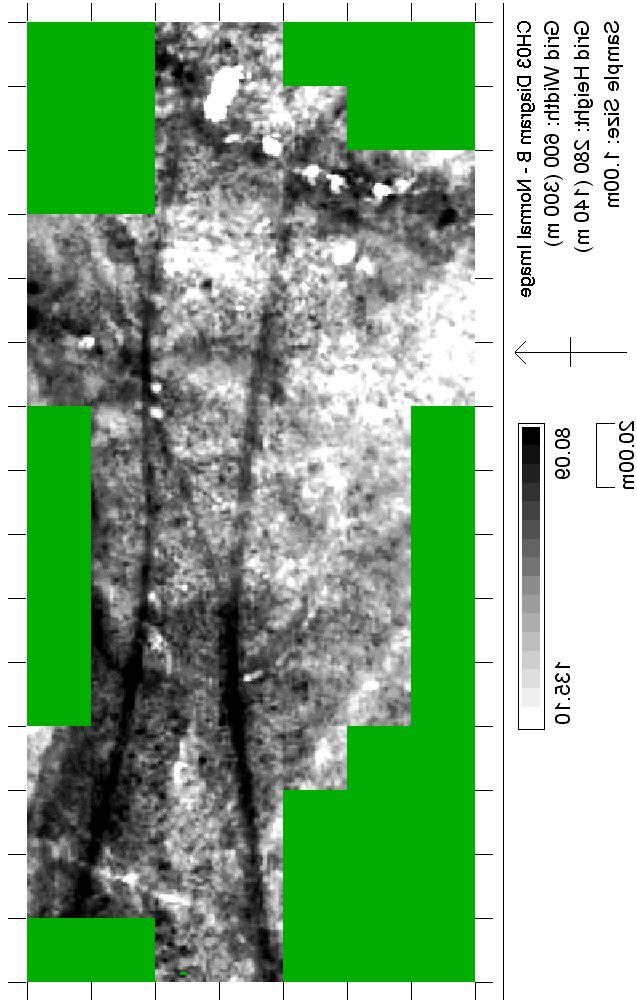
1 A Resistivity Survey Of Combe Hill Causewayed Enclosure Near Willingdon, East Sussex, July-August 2003 Report By David Staveley August 2003 Introduction From 28 th July to 8 th August 2003, the Brighton & Hove Archaeological society conducted a Resistivity survey on 71 grids of 20 by 20 metres on the site of the Neolithic Causewayed Enclosure and two adjacent barrows on Combe Hill, near Willingdon, East Sussex. The purpose of the survey was to identify features hinted at by the Royal Commission earthwork survey of the enclosure (Oswald & Field 1995). The features sought were the outer enclosure circuit and also two tails attached to the two bronze-age barrows flanking the enclosure on the hill. Any other features found internal to the enclosure were to be considered a bonus. The location of the enclosure is on the top of a chalk ridge on the northern edge of the South Downs. The topsoil is very thin, just a few centimetres thick judging by the depth the fixed probes penetrated, and the site is used for pasture. Coupled with the extremely dry weather we had before and during the survey, this left the site in far too dry a condition for a decent set of results to be gained. The conditions affected the site to the extent that some of the ditches of the enclosure actually gave a higher reading than their surroundings, a process described by Anthony Clark (1996 p.49). Nevertheless, some results were obtained, though they are ephemeral. A magnetometry survey may help resolve certain possible interesting features shown by this Resistivity survey. Method Diagram A shows the layout of the grids in relation to the RCHME earthwork survey results. The grids were laid out using tapes and the baseline reaches from roughly the centre of the bowl barrow to the west of the enclosure through roughly the centre of the disc barrow to the east of the enclosure. A TR Systems Resistivity Meter was used in its standard configuration with readings being taken every square meter. The resulting data was processed using Snuffler, with two plots produced. Both plots had the edges of the grids matched up and were de-spiked. Thereafter, the first plot (Diagram B) was interpolated, whilst the second plot (Diagram C) was flattened using a High Pass Filter before being interpolated. Results & Interpretation The results as interpreted from the two plots (Diagrams B & C) are shown on Diagram D. The following interpretive text refers to features shown on this diagram. Geology Despite the dry conditions on site, the geological background was quite noisy, though fortunately free from the pockets of Clay With Flints that plague surveys on this type of geology. Some geological features relating to the slope of the hill can be seen on
2 the northern edge of the survey results, whilst the readings for the general background seemed to be higher resistance in the west than the east. Modern Of the modern features visible, the two trackways that currently pass through the site are easily visible, crossing the site from east to west. Also visible is a low resistance linear feature similar to the other two trackways but not as clearly defined. It runs from the northwest, climbing the hill heading ESE, crossing the northern trackway roughly at the point that trackway crosses the inner enclosure and stopping when it reaches the southern trackway. The nature of the feature as seen on the survey coupled with its termination at another modern feature point to it being another trackway, now no longer visible but once in use at the same time as the southern trackway. Bronze-Age Of the Bronze-Age features, the outlines of the two barrows are just visible, but their tails appear much more strongly, though both of them different in character. The tail that leads SSE from the western bowl barrow seems to be formed of a series of high resistance blobs, contained within an area of lower resistance with a few blobs of lower resistance also within this area. The whole seems to curve slightly to the south with two thin low resistance linear features making an appearance halfway down the tail. Whilst the high resistance blobs show quite a strong deviation from the background, they were not noted apart from being part of the tail structure as a whole. What does make its presence felt on the ground are two small mounds just east of the tail, around where the two linear features start, that shows on the RCHME survey and also on the Resistivity survey as blobs similar to those seen in the tail. It should be noted here that some sandstone could be seen in the top of one of these mounds. The tail on the eastern disc barrow appears on the RCHME survey to be composed of two separate features and this appears to be the case on the Resistivity survey results. Unlike the RCHME survey however, these seem to pass through the barrow rather than stopping at it, though they don t continue for much distance past it. These two separate tails are quite different in character to the tail on the western bowl barrow. They are high resistance and linear rather than curved, much thinner and more continuous rather than blobby. The stronger feature appears to be the tail which heads NNW from the barrow. The second tail heads NW and where it hits some high resistance geology at the edge of the survey area, it shows up as low resistance in comparison. A third even more ephemeral tail may possibly be seen also heading northwest from the barrow, but this is not marked on the interpretation diagram. A fourth linear feature, stronger than the others radiating from the disc barrow can be seen to the southwest of the barrow. It is not aligned on the barrow, seeming to stop at the southern trackway, though the geology in the area south of the barrow is noisy and makes things difficult to see. The tails on both barrows are assumed to be bronze-age because of their association with the barrows, though this is of course far from being a certainty. The linear feature on the south-east side is also assumed to be bronze-age due to its similarity to
3 the other linear feature associated with the barrow, but this is even more tenuous. The purpose of all the features other than the barrows can only be guessed at, so here are my guesses, such as they are. The enclosure itself seems to be almost bounded in by the combination of these features and the natural escarpment to the north. A hill that has been enclosed in a similar manner is Bow Hill in West Sussex, though this is Iron- Age. A more suitable comparison can be made with Long-Burgh near Alfriston. There, the long barrow along with an oval barrow and round barrows are isolated on a spur of the downs by a cross-dyke or linear earthwork. It may be that these linear features were designed to mark the land as somehow special and apart from everyday existence. Perhaps they were designed to mark a boundary that should not be crossed. The association of the barrows with these features raises two other possibilities. Firstly, that the ancestors buried there were put there along with the linear features to help enclose and protect against an area that was somehow considered contaminated. Secondly, that the burial of your ancestors at such a spot is meant to cement your claim on the area, and its associated history. Whilst some of these ideas may seem reasonable for the relatively simple linear earthworks on the eastern and southern sides of the enclosure, the western tail is more confused. For the blobbyness of the western tail, I have the following two possible explanations apart from the simple linear boundary theory. Firstly, the area to the west was cultivated in prehistory and the blobs are clearance cairns dumped at the edge of the field. There are field systems further down the hill to the west, but whether they went further up than is now visible is unknown. My second guess is that flints were quarried and/or worked in the area, which would also explain the low resistance blobs associated with the high resistance ones. Neolithic The results for the Neolithic features are both disappointing and fascinating in equal measure. The inner enclosure is visible, though not clear enough to pick out the causeways. Unfortunately, the outer enclosure is only visible to the west, where the earthworks can be seen, with a hint of its continuation to the south where it has been flattened. A better response may have been gained when the site is not so dry. It is in the visible enclosure ditches that you can see the extreme effect of the dry weather, where at some points the readings are higher than the surrounding area. The area comprising the ditch and bank is thicker than shown in the diagram, but unfortunately the results are not clear enough to properly define its limits. It is within the inner enclosure that we unexpectedly find features of interest. Firstly, two features composed of what seem at first glance to be large posts must be described. Firstly, on the south side of the inner enclosure is a semicircular arrangement of nine low readings. This palisade, which seems the most likely cause, almost completely covers the southern entrance to the enclosure. If it is indeed a palisade, the posts must have been very thick to show up so well on the plot. The second palisade consists of what seems to be a linear arrangement of eight posts heading NW-SE and close by the eastern entrance to the inner enclosure. It doesn t seem to stretch right to the entrance, and indeed no postholes were found within the entrance by Seton-Williams (Drewett 1994 p.10). That both of these palisades are associated with entrances into the enclosure is interesting, perhaps they were used to somehow control the use of these entrances. A Neolithic posthole structure can be
4 seen to be associated with a causeway at Whitehawk, but it is of a different form to those at Combe Hill and it is associated with a small causeway rather than a larger entrance (Curwen 1934 p.105). The semicircular enclosure on the southern side of the enclosure is similar in form to a mortuary enclosure, such as those found under long barrows (Thomas 1991 p.132), but it is rather out of context. Moving onto more ephemeral objects within the inner enclosure is the possibility of yet another enclosure circuit. It is marked on the map as a thin ellipse, but the plot shows something much thicker. It is roughly 43 metres East-West and 35 metres North-South. It is composed of a rather fuzzy collection of slightly higher readings, strongest on its western edge, but it does seem to be concentric both in proportion and distance to the main inner enclosure within which is sits. Another possible feature sits just within this possible new enclosure on its Southwestern side, just north of the modern path. This is a small low resistance ring roughly 9 metres across, with a low resistance spot in its centre. Acknowledgements I would like to thank the members of the Brighton & Hove Archaeological Society for all their hard work in the face of such gruelling weather, challenging undergrowth and curious farm animals. They are (in order of appearance) : John Funnell, Donna Angel, Deon Whittakar, Bill Santer, Karol Eager, Dot McBrien, Penny Edgar, Leo Jago, Andrew Musselwhite, Fiona Whittakar, Joan MacGregor and Share Price. I would also like to thank English Heritage, English Nature, Dave Pearce at Eastbourne Borough Council, the tenant farmer, Richard Brown and Sarah-Jane Webb for proof reading. References Clark, A., Seeing Beneath The Soil, Routledge 1996 (Revised) Curwen, E.C., Excavations in Whitehawk Neolithic Camp, Brighton, , Antiq. Journ. 14 (2) 1934 Drewett, P., V. Seton Williams Excavations At Combe Hill, Sussex Archaeological Collections Vol Oswald, A. & Field, D., A Causewayed Enclosure On Combe Hill, Eastbourne, East Sussex, RCHME 1995 Thomas, J., Understanding The Neolithic, Routledge 1991
5
6

7

8
Report on Geophysical Survey Na Vrsku, Sahy, Slovakia Coordinates: 48⁰,4,45 N 18⁰,56,23 E. April 2018
 Report on Geophysical Survey Na Vrsku, Sahy, Slovakia Coordinates: 48⁰,4,45 N 18⁰,56,23 E April 2018 Mark Graham BA(Hons), BSc, MA Grampus Heritage and Training Ltd, Ashgill, Threapland, Wigton, Cumbria,
APPENDIX B: REPORT ON GEOPHYSICAL SURVEY, JULY 1998
 APPENDIX B: REPORT ON GEOPHYSICAL SURVEY, JULY 1998 by Andy Payne Introduction A geophysical survey was carried out at Le Yaudet, Ploulec h, Brittany as part of the ongoing investigation into the archaeology
General Editor: Vince Russett
 YCCCART 2014/Y20 North Somerset HER 2015/11 Manual survey using an electronic, hydryostatic level (NIVCOMP) at Wemberham Roman Villa YATTON, CONGRESBURY, CLAVERHAM AND CLEEVE ARCHAEOLOGICAL RESEARCH TEAM
Northamptonshire Archaeology
 Northamptonshire Archaeology Archaeological Geophysical Survey At Sulgrave Castle Green, Sulgrave, Northamptonshire August 2007 Adrian Butler November 2007 Report 07/192 Northamptonshire Archaeology 2
A Geophysical Survey at Storey s Meadow West Meon, Hampshire
 A Geophysical Survey at Storey s Meadow West Meon, Hampshire February 28 th March 1 st 2014 Liss Archaeological Group Ref: SM-14 Carried out by Liss Archaeological Group on behalf of - The Friends of Corhampton
Swaledale and Arkengarthdale Archaeology Group
 Swaledale and Arkengarthdale Archaeology Group Bellerby Moor GPS Earthwork Survey Report prepared by: Tim Laurie and Stephen Eastmead. Swaledale and Arkengarthdale Archaeology Group. January 27/01/2012.
Excavations at Clocken Syke Farm, Dairy Lane,Dacre By Nidderdale Iron-age Archaeology community group 2015 and 2016
 Excavations at Clocken Syke Farm, Dairy Lane,Dacre By Nidderdale Iron-age Archaeology community group 2015 and 2016 1 Introduction The Nidderdale Iron-Age group and its forerunners have been investigating
Detailed Magnetometer Survey at Whitehawk Camp, Brighton, East Sussex NGR: (TQ ) Scheduled Ancient Monument:
 Scheduled Ancient Monument:") Detailed Magnetometer Survey at Whitehawk Camp, Brighton, East Sussex NGR: 532938 104787 (TQ 32938 04787) Scheduled Ancient Monument: 1010929 ASE Project No: P106 ASE Report No. 2014165 By John Cook BSc
Detailed Magnetometer Survey at Whitehawk Camp, Brighton, East Sussex NGR: 532938 104787 (TQ 32938 04787) Scheduled Ancient Monument: 1010929 ASE Project No: P106 ASE Report No. 2014165 By John Cook BSc
Geophysical Survey. Ballymount Co. Dublin. Licence Ref. 02R029. By John Nicholls Margaret Gowen & Co. Ltd. For LRT
 Geophysical Survey Ballymount Co. Dublin Licence Ref. 02R029 By John Nicholls Margaret Gowen & Co. Ltd. For LRT 4 th April 2002 Illustrations List of Figures Figure 1 Site Location 1: 50000 Figure 2 Survey
Land at Model Farm Cottages, Bath Road, Sonning, Berkshire
 Land at Model Farm Cottages, Bath Road, Sonning, Berkshire An Archaeological Evaluation for The Keen Partnership by Andy Taylor Thames Valley Archaeological Services Ltd Site Code BRS 04/55 June 2004 Summary
Report on the Geophysical survey undertaken at Kouphovouno between 28 th June and 2 nd July.
 Report on the Geophysical survey undertaken at Kouphovouno between 28 th June and 2 nd July. Introduction: A team comprising of two undergraduate students (Anna Moles & James Taylor) and two postgraduates
Geophysical Survey Report
 Geophysical Survey Report Wickham Bushes, Bracknell, Berkshire for Thames Valley Archaeological Services December 2004 J1957 K T Donaldson Document Title: Client: Stratascan Job No: Techniques: Geophysical
King s Knot, Stirling. Data Structure Report Radar Profile Survey
 King s Knot, Stirling Data Structure Report Radar Profile Survey August 2012 REPORT INFORMATION SHEET National Grid Reference NS 78896 93646 Address Parish Council NMRS King s Knot Park, Stirling Stirling
Archaeological Evaluation of Land off Hubbards Lane, Boughton Monchelsea, Kent
 Archaeological Evaluation of Land off Hubbards Lane, Boughton Monchelsea, Kent NGR: 576190 151300 Site Code: HUB/EV/16 (Planning Application: 16/500014/OUT/MA) SWAT Archaeology The Office, School Farm
MAPPING BEDROCK: Verifying Depth to Bedrock in Calumet County using Seismic Refraction
 MAPPING BEDROCK: Verifying Depth to Bedrock in Calumet County using Seismic Refraction Revised December 13, 2011 Dave Hart Wisconsin Geological and Natural History Survey INTRODUCTION Seismic refraction
Geophysical surveying of the Knights Hospitallers Preceptory site at Hogshaw in Buckinghamshire
 Geophysical surveying of the Knights Hospitallers Preceptory site at Hogshaw in Buckinghamshire English Heritage Monument number 1405586 Case number SL00097304 PROGRESS REPORT AND RESULTS SO FAR Peter
CHERHILL. New Village Hall Site JANUARY REPORT No
 CHERHILL New Village Hall Site JANUARY 2016 REPORT No. 1017.205 talits@btinternet.com 01793 731974 Summary TALITS Archaeological Services was commissioned by Project Manager, Simon Tomlinson, to undertake
Ground Penetrating Radar Survey Report:
 Ground Penetrating Radar Survey Report: Caiphas Burial Tomb Project Israel Data Acquired May 29, 2008 Report compiled June 4, 2008 Survey and Report Published by Mnemotrix Israel, Ltd. Chief GPR Surveyor,
A Survey of St Michael and All Angels Churchyard Hamstall Ridware
 Project No 6 A Survey of St Michael and All Angels Churchyard by M R Holland Annie Saunders MA March 2003 Table of Contents Introduction Methods Acknowledgements Appendix A Geophysics 3 3 5 6 Table of
A geophysical and topographic survey report
 A geophysical and topographic survey report carried out at Weaverthorpe, North Yorkshire on behalf of the Friends of St Andrews Church, Weaverthorpe between June and October, 2011 Landscape Research Centre
Former transport depot, Charlton Road, Charlton, Shepperton, Surrey
 Former transport depot, Charlton Road, Charlton, Shepperton, Surrey An Archaeological Evaluation for St James Homes Ltd by Steve Ford Thames Valley Archaeological Services Ltd Site Code CRC06/117 June
Geophysical Survey Report No. 8 Killyglen Co. Antrim
 Geophysical Survey Report No. 8 Killyglen Co. Antrim Dr Steven Trick Geophysical Survey Report No. 8 Dr Steven Trick April 2006 1 Introduction 1.1 This report presents the results of a third geophysical
Geophysical Survey Report
 Report Lost Mansion of Nydfwch, Penllergare, Swansea for January 2008 J2449 John Cook BSc. (Hons) Document Title: Client: Stratascan Job No: Techniques: Report Lost Mansion of Nydfwch, Penllergare, Swansea
Collfryn Ring-ditch, Guilsfield, Powys
 CPAT Report No 1122 TRIAL EXCAVATION 2011 THE CLWYD-POWYS ARCHAEOLOGICAL TRUST CPAT Report No 1122 TRIAL EXCAVATION 2011 I Grant December 2011 Report for Cadw The Clwyd-Powys Archaeological Trust 41 Broad
Geophysical Surveys at Moncrieffe Hill Fort, Perthshire
 Geophysical Surveys at Moncrieffe Hill Fort, Perthshire P.Morris Site Type FORT Canmore ID 28058 Site Number NO11NW 7 NGR NO 1313 1988 Council PERTH AND KINROSS Parish DUNBARNEY Geophysical Surveys at
EROSIONAL FEATURES. reflect
 reflect Have you ever looked at the land around you and wondered what processes shaped what you see? Perhaps you see mountains, valleys, rivers, or canyons. Do you know how long these geologic features
Archaeological Evaluation at Monkcastle Project KHAP102
 Archaeological Evaluation at Monkcastle Project KHAP102 Ralph Shuttleworth BSc Phd FSAScot September 2014 1 Contents Quality Assurance 2 Acknowledgements 2 List of Figures 3 Introduction 4 General Description
Activity: A Satellite Puzzle
 Activity: A Satellite Puzzle Introduction Satellites provide unique views of Earth. The imagery acquired by these space platforms reveal weather systems and broad-scale circulation patterns that can be
Roman Farm, Nettleden, Hemel Hempstead, Hertfordshire
 Roman Farm, Nettleden, Hemel Hempstead, Hertfordshire An Archaeological Watching Brief for Mercantile Land Development Ltd by Siân Anthony Thames Valley Archaeological Services Ltd Site Code RFN01/82 October
This Unit is suitable for candidates with no previous archaeological experience but who have an interest in history and/or archaeology.
 National Unit specification: general information Unit code: H29B 12 Superclass: DC Publication date: August 2012 Source: Scottish Qualifications Authority Version: 01 Summary This Unit introduces candidates
GEOPHYSICAL SURVEY REPORT. Timolin, County Kildare. Date: 18/01/2016. Licence: 15R0133
 GEOPHYSICAL SURVEY REPORT Date: 18/01/2016 Licence: 15R0133 J. M. Leigh Surveys 124 Oaklawn West Leixlip County Kildare www.jmlsurveys.com 01 615 4647 Consultants. J. M. Leigh Surveys 124 Oaklawn West,
Archaeological Evaluation and Assessment of Land at Roselands, Sedlescombe, East Sussex
 Archaeological Evaluation and Assessment of Land at Roselands, Sedlescombe, East Sussex NGR: TQ 78013 18096 Site Code: ROSE/EV/16 (Planning Application: RR/2015/2248/P) SWAT Archaeology The Office, School
Erosional Features. What processes shaped this landscape?
 Have you ever looked at the land around you and wondered what processes shaped what you see? Perhaps you see mountains, valleys, rivers, or canyons. Do you know how long these geologic features have been
HADRIANS WALL NEWCASTLE UNIVERSITY
 HADRIANS WALL NEWCASTLE UNIVERSITY WEEK 3 FRONTIER COMMUNITIES: LIFE IN THE NORTHERN FRONTIER LATE 1ST-EARLY 3RD CENTURY EXPLORING MAGNETOMETRY Archaeologists use a number of methods and types of information
Ground Penetrating Radar Survey Report: Follow-up Ground Truth Study
 Ground Penetrating Radar Survey Report: Follow-up Ground Truth Study 2005 Tell es-safi/gath Archaeological Project Figure 1: Tell es-safi GPR ground-truth study. Data Acquired August 4, 2005 Report compiled
T H A M E S V A L L E Y S E R V I C E S. Land between 138 and 142 Southcote Lane, Reading, Berkshire. Archaeological Evaluation
 T H A M E S V A L L E Y ARCHAEOLOGICAL S E R V I C E S Land between 138 and 142 Southcote Lane, Reading, Berkshire Archaeological Evaluation by James McNicoll-Norbury Site Code: SLR09/121 (SU 6935 7215)
Pen Selwood Geophysical Survey
 Pen Selwood Geophysical Survey 2015-2017 Prepared for: The South Somerset Archaeological Research Group and the Pen Selwood History Society Prepared by: Geoff Parcell 9 February 2018 Report Number: /GS/1015!
GeoArch. Report 2016/13. Geophysical survey in the graveyard of the Church of Ss David Lewis & Francis Xavier, Usk
 GeoArch Report 2016/13 Geophysical survey in the graveyard of the Church of Ss David Lewis & Francis Xavier, Usk Dr Tim Young 16 th May 2016 Geophysical survey in the graveyard of the church of Ss David
Evaluation/Monitoring Report No. 259
 SITE 100M EAST OF 16 LEARMORE ROAD CASTLEGORE CASTLEDERG COUNTY TYRONE LICENCE NO.: AE/13/36E NAOMI CARVER 1 Site Specific Information Site Name: 100m east of 16 Learmore Road, Castlederg, Co. Tyrone Townland:
Land adjacent to 103 Pound Lane, Sonning, Berkshire
 Land adjacent to 103 Pound Lane, Sonning, Berkshire An Archaeological Evaluation for Hicks Development Ltd by James McNicoll-Norbury Thames Valley Archaeological Services Ltd Site Code PLS 09/50 June 2009
Whitelands College, West Hill, Putney, London Borough of Wandsworth
 Whitelands College, West Hill, Putney, London Borough of Wandsworth An Archaeological Evaluation for Crest Nicholson Residential (South) Ltd by Sian Anthony Thames Valley Archaeological Services Ltd Site
Geophysical Survey Report No. 13. Cornashee Co. Fermanagh. Season 2: Magnetometry survey. Dr Steven Trick
 Geophysical Survey Report No. 13 Cornashee Co. Fermanagh Season 2: Magnetometry survey Dr Steven Trick Cornashee, Co. Fermanagh Season 2: Magnetometry survey Geophysical Survey Report No. 13 Dr Steven
SS5 The Neolithic and early Bronze Age archaeology of the Raunds area investigated by geophysical survey
 SS5 The Neolithic and early Bronze Age archaeology of the Raunds area investigated by geophysical survey Andrew Payne SS5.1 Introduction Extensive tracts of the Raunds area were the subject of geophysical
Archaeology of East Oxford Project: Minchery Paddock 2012 Trench 1 Excavation Narrative report
 Archaeology of East Oxford Project: Minchery Paddock 2012 Trench 1 Excavation Narrative report Julian Stern and Olaf Bayer Introduction & Summary Trench 1 was the northern most of three trenches excavated
Northamptonshire Archaeology
 Northamptonshire Archaeology Geophysical Surveys at Barn Close and Harpit Harpole, Northamptonshire January 2006 December 2007 Adrian Butler April 2008 Report 08/70 Northamptonshire Archaeology 2 Bolton
S E R V I C E S S O U T H
 T H A M E S V A L L E Y ARCHAEOLOGICAL S E R V I C E S S O U T H The orthbrook Site, West Durrington, Worthing, West Sussex Area B Archaeological Evaluation by Sean Wallis Site Code: CW11/113 (TQ 1070
A Geophysical Survey of a Roman Tile Kiln. Dell Quay, Chichester, West Sussex
 A Geophysical Survey of a Roman Tile Kiln Dell Quay, Chichester, West Sussex Neville Haskins Chichester District Archaeology Society April 2007 Summary A fluxgate gradiometer survey was carried out in
Land off Luton Road, Farley Hill, Luton, Bedfordshire
 Land off Luton Road, Farley Hill, Luton, Bedfordshire An Archaeological Evaluation for 3Sixty Construction Ltd by Andrew Mundin Thames Valley Archaeological Services Ltd Site Code LRL 08/82 August 2008
Acrefield Cottage, Winkfield Street, Maidens Green, Winkfield, Windsor, Berkshire
 Acrefield Cottage, Winkfield Street, Maidens Green, Winkfield, Windsor, Berkshire An Archaeological Watching Brief For Mr and Mrs Elia by Pamela Jenkins Thames Valley Archaeological Services Ltd Site Code
SOTMAS Geophysical Survey of Norbury Moated Manor house
 SOTMAS Geophysical Survey of Norbury Moated Manor house Illustration from Dr. Plot by Burghers of Norbury Manor as it was in 1686. The gargoyle recovered from the moat. Introduction Ralph de Botiller succeeded
Explore the Site! Mound A. Mound F. Mound B
 Mound F Explore the Site! Mound B Ridges Mound A Plaza Mound C Researchers have been studying Poverty Point for over a century. In that time, they have found clues about life in the past in some unexpected
Todmorden Wind Farm Geotechnical Site Investigations, Calderdale, West Yorkshire
 Todmorden Wind Farm Geotechnical Site Investigations, Calderdale, West Yorkshire Archaeological Watching Brief Report Oxford Archaeology North March 2013 I and H Brown Issue No: 2012-13/1370 OA North Job
Physics (B): Physics in Context
: Physics in Context") Centre Number Surname Candidate Number For Examinerʼs Use Other Names Candidate Signature Examinerʼs Initials General Certificate of Education Advanced Level Examination June 2011 Question 1 2 Mark Physics
Centre Number Surname Candidate Number For Examinerʼs Use Other Names Candidate Signature Examinerʼs Initials General Certificate of Education Advanced Level Examination June 2011 Question 1 2 Mark Physics
SECTION 7: COMPARING THE HLC WITH OTHER SPATIAL DATASETS
 Cranborne Chase and West Wiltshire Downs AONB Historic Landscape Characterisation Project SECTION 7: COMPARING THE HLC WITH OTHER SPATIAL DATASETS Full Report July 2008 409 of 431 CONTENTS 7.1 Introduction...
Ground Penetrating Radar Survey of a Portion of East End Cemetery, Cadiz, Kentucky
 Ground Penetrating Radar Survey of a Portion of East End Cemetery, Cadiz, Kentucky January 2011 Report prepared by Anthony L. Ortmann, Ph.D. Assistant Professor Department of Geosciences Murray State University
Geophysical Survey Report
 Report Fin Cop Hill Fort for Archaeological Research Services May 2009 Job No. J2591 Richard Smalley BA (Hons) AIFA Document Title: Client: Stratascan Job No: Techniques: Report Fin Cop Hill Fort Archaeological
Geophysical Survey of Wisconsin Burial Site BRO-0033 Wixom Cemetery, Rock County, Wisconsin
 Lawrence University Lux Archaeological Reports Anthropology Department 6-2015 Geophysical Survey of Wisconsin Burial Site BRO-0033 Wixom Cemetery, Rock County, Wisconsin Peter N. Peregrine Lawrence University
Case No: SL Monument No: CU292, List Entry Location: NY 0038, 3002 OASIS:
 Discovering Derventio Community Archaeology Project Geophysical Survey of Burrow Walls and Calva Hill, Workington, Cumbria Grampus Heritage and Training Ltd Case No: SL00121846 Monument No: CU292, List
Figure 45. Plan of Pukaroro drawn from aerial photograph. K. Jones, drawn by C. Edkins, DOC.
 Figure 45. Plan of Pukaroro drawn from aerial photograph. K. Jones, drawn by C. Edkins, DOC. 101 length, and there are cross-rows forming semi-enclosures. House floors are also present at the southern
Assessment of biological remains from excavations at Newbridge Quarry, Pickering, North Yorkshire (site code: NBQ99)
") Reports from the Environmental Archaeology Unit, York 2000/27, 5 pp. Assessment of biological remains from excavations at Newbridge Quarry, Pickering, North Yorkshire (site code: NBQ99) by Allan Hall,
Reports from the Environmental Archaeology Unit, York 2000/27, 5 pp. Assessment of biological remains from excavations at Newbridge Quarry, Pickering, North Yorkshire (site code: NBQ99) by Allan Hall,
Geophysical survey at Stoke Mandeville deserted village site
 Geophysical survey at Stoke Mandeville deserted village site Buckinghamshire Archaeological Society GEOPHYSICAL SURVEY REPORT / March 2014 SURVEY: Members of the BAS Active Archaeology Group led by Gary
A303 Stonehenge Highways England Consultation the response from Honouring the Ancient Dead
 A303 Stonehenge Highways England Consultation the response from Honouring the Ancient Dead Highways England (HE) plans along the A303, A358 and A30 to create a world-class Expressway to link the south
Weathering, Erosion and Deposition
 Weathering, Erosion and Deposition Shaping the Earth s Surface Weathering the process of breaking down rocks into smaller fragments Erosion the transport of rock fragments from one location to another
Introducti on. Land Survey. Geomagnetic Survey. Geomagnetic Results and Interpretati ons - Conclusions and Recommendations C
 m M 42A86SW8281 63.42 PRICE 010 C O H T E H l 42A86SW828I 63.42 PRICE 010C Introducti on Land Survey Geomagnetic Survey Geomagnetic Results and Interpretati ons - Conclusions and Recommendations - - -
The field is crossed by the Essex Water Company s pipeline, the ground was deep ploughed either side with a decompactor.
 EHER 9178 and EHER 9181 LOCATION: WORMINGFORD, ESSEX Field (known as Metlands) to the south of the River Stour, east of Staunch Farm and west of Wormingford Mere and Lodge Hills, centred on NGR TL924328
Bramley Grange, Horsham Road, Bramley, Surrey
 Bramley Grange, Horsham Road, Bramley, Surrey An Archaeological Evaluation for English Villages Housing Association by Stephen Hammond Thames Valley Archaeological Services Ltd Site Code BGB 03/95 October
Archaeological Surveys Ltd. East Kennett Manor Farm East Kennett Wiltshire. Mr & Mrs J Cameron MAGNETOMETER AND EARTH RESISTANCE SURVEY REPORT.
 Archaeological Surveys Ltd East Kennett Manor Farm East Kennett Wiltshire MAGNETOMETER AND EARTH RESISTANCE SURVEY REPORT for Mr & Mrs J Cameron Kerry Donaldson and David Sabin May 2014 Ref. no. 536 ARCHAEOLOGICAL
Culham Court, Aston, Remenham, Berkshire
 Culham Court, Aston, Remenham, Berkshire An Archaeological Evaluation for Woody Clark Limited by Sean Wallis Thames Valley Archaeological Services Ltd Site Code CCA 07/117 October 2007 Summary Site name:
Map 12: Ayrshire Coast: Doonfoot Beach to Dunure Map Content Descriptions
 Map 12: Ayrshire Coast: Doonfoot Beach to Dunure Map Content Descriptions 1. Built Heritage and Archaeology A total of twenty three sites were located in the area covered by Map 12. Of these seventeen
REVISION: MAPWORK 18 SEPTEMBER 2014
 REVISION: MAPWORK 18 SEPTEMBER 2014 Lesson Description In this lesson we revise: Various mapwork calculations Summary Relative Position Bearing is the angular (angle) distance between two points True Bearing
Redgrave Pinsent Rowing Lake, Caversham Lakes, Henley Road, Caversham, Oxfordshire
 Redgrave Pinsent Rowing Lake, Caversham Lakes, Henley Road, Caversham, Oxfordshire An Archaeological Evaluation: Phase 2 for Mott McDonald Ltd by Sarah Coles and Sian Anthony Thames Valley Archaeological
Excavation of a circular ditch and bank enclosure at Ingmoor Moss, Raisbeck (NY658077) Funded by
 Funded by") Excavation of a circular ditch and bank enclosure at Ingmoor Moss, Raisbeck (NY658077) Funded by 1 Contents Page SUMMARY 5 1.1 Circumstances of Project 5 1.2 Characteristics of the circular features identified
Excavation of a circular ditch and bank enclosure at Ingmoor Moss, Raisbeck (NY658077) Funded by 1 Contents Page SUMMARY 5 1.1 Circumstances of Project 5 1.2 Characteristics of the circular features identified
Prehistoric routes through the Chilterns our ancestors knew their geology!
 Prehistoric routes through the Chilterns our ancestors knew their geology! The oldest routes, without doubt, are the river valleys. River valleys were the most likely pathways during the Palaeolithic period
25 Whiteknights Road, Reading, Berkshire
 25 Whiteknights Road, Reading, Berkshire An Archaeological Evaluation for B & M Care by Sean Wallis Thames Valley Archaeological Services Ltd Site Code WRR07/74 July 2007 Summary Site name: 25 Whiteknights
A Late Iron Age and Romano-British settlement at Black Plantation, Richmond, North Yorkshire
 ISSN 1478-7008 A Late Iron Age and Romano-British settlement at Black Plantation, Richmond, North Yorkshire Mitchell Pollington and Marcus Jecock Archaeological Investigation Report Series AI/5/2005 A
HISTORY OF CONSTRUCTION FOR EXISTING CCR SURFACE IMPOUNDMENT PLANT GASTON ASH POND 40 CFR (c)(1)(i) (xii)
(1)(i) (xii)") HISTORY OF CONSTRUCTION FOR EXISTING CCR SURFACE IMPOUNDMENT PLANT GASTON ASH POND 40 CFR 257.73(c)(1)(i) (xii) (i) Site Name and Ownership Information: Site Name: E.C. Gaston Steam Plant Site Location:
HISTORY OF CONSTRUCTION FOR EXISTING CCR SURFACE IMPOUNDMENT PLANT GASTON ASH POND 40 CFR 257.73(c)(1)(i) (xii) (i) Site Name and Ownership Information: Site Name: E.C. Gaston Steam Plant Site Location:
Magnetics: Fundamentals and Parameter Extraction
 : Fundamentals and Parameter Extraction Stephen Billings Magnetic module outline fundamentals Sensor systems Data examples and demo Parameter extraction Concepts Real-world examples Classification Using
1 What is Science? Worksheets CHAPTER CHAPTER OUTLINE
 www.ck12.org Chapter 1. What is Science? Worksheets CSS AP Physics 1 2015-16 Summer Assignment Part 1 of 3 CHAPTER 1 What is Science? Worksheets CHAPTER OUTLINE 1.1 Scientific Inquiry 1.2 Fundamental Units
Archaeological Monitoring of Land at Seacrest, Cliff Drive, Warden, Isle of Sheppey, Kent
 Archaeological Monitoring of Land at Seacrest, Cliff Drive, Warden, Isle of Sheppey, Kent Site Code SEA/WB/15 Report for Kevin & Lesley O Brian Date of report 14/10/2015 SWAT ARCHAEOLOGY Swale and Thames
GEOPHYSICAL SURVEY, HARPLEY LONG BARROW
 GEOPHYSICAL SURVEY, HARPLEY LONG BARROW GPR, Magnetic and Resistivity Survey The slight earthwork remains of the Long Barrow at Harpley, with minor road cutting through northern flank, viewed from the
Former PLA Recreation Ground, The Drive, Ilford, London Borough of Redbridge
 Former PLA Recreation Ground, The Drive, Ilford, London Borough of Redbridge An Archaeological Evaluation for CgMs Ltd by Steve Ford Thames Valley Archaeological Services Ltd Site Code FPL06 May 2006 Summary
Comparative Analysis of Hurricane Vulnerability in New Orleans and Baton Rouge. Dr. Marc Levitan LSU Hurricane Center. April 2003
 Comparative Analysis of Hurricane Vulnerability in New Orleans and Baton Rouge Dr. Marc Levitan LSU Hurricane Center April 2003 In order to compare hurricane vulnerability of facilities located in different
Comparison between predicted liquefaction induced settlement and ground damage observed from the Canterbury earthquake sequence
 Power, P.M. & Jacka, M. (2013) the Canterbury earthquake sequence Proc. 19 th NZGS Geotechnical Symposium. Ed. CY Chin, Queenstown Comparison between predicted liquefaction induced settlement and ground
Survey of Garreg-hir 15 May ) Introduction 2) Equipment used and Conditions for Survey 3) The Survey 3.1) Character of Hill
 Introduction 2) Equipment used and Conditions for Survey 3) The Survey 3.1) Character of Hill") Survey of Garreg-hir 15 May 2011 The Team: John Barnard, Graham Jackson and Myrddyn Phillips 1) Introduction Garreg-hir (Section 31A, OS 1:50000 Map 136, Grid Ref. SN998977) is listed as a marginal Marilyn
Survey of Garreg-hir 15 May 2011 The Team: John Barnard, Graham Jackson and Myrddyn Phillips 1) Introduction Garreg-hir (Section 31A, OS 1:50000 Map 136, Grid Ref. SN998977) is listed as a marginal Marilyn
EXCAVATION OF AN ENCLOSURE SITE AT ROSSNAREE, (BRÚ NA BÓINNE) CO. MEATH. 10E0242
 CO. MEATH. 10E0242") Preliminary Report Committee for Archaeology Royal Irish Academy EXCAVATION OF AN ENCLOSURE SITE AT ROSSNAREE, (BRÚ NA BÓINNE) CO. MEATH. 10E0242 Preliminary Report, Excavation 2011 Conor Brady Department
Preliminary Report Committee for Archaeology Royal Irish Academy EXCAVATION OF AN ENCLOSURE SITE AT ROSSNAREE, (BRÚ NA BÓINNE) CO. MEATH. 10E0242 Preliminary Report, Excavation 2011 Conor Brady Department
Evaluation/Monitoring Report No. 152
 Evaluation/Monitoring Report No. 152 150m west of 7 Portmore Rd. Portmore Lower Ballinderry County Antrim LICENCE NO.: AE/07/241 David McIlreavy 1 Site Specific Information Site Name Townland County :
Long Ashes Holiday Park Threshfield North Yorkshire
 on behalf of GVA Humberts Leisure for Lakeland Leisure Estates Ltd Long Ashes Holiday Park Threshfield North Yorkshire archaeological evaluation report 3027 December 2012 Contents 1. Summary 1 2. Project
Cambridge International Examinations Cambridge International General Certificate of Secondary Education
 Cambridge International Examinations Cambridge International General Certificate of Secondary Education *1391603277* GEOGRAPHY 0460/23 Paper 2 May/June 2015 Candidates answer on the Question Paper. Additional
BUTE MAP 6: GARROCH HEAD to STRAVANNAN BAY
 BUTE MAP 6: GARROCH HEAD to STRAVANNAN BAY Hinterland Geology and Coastal Geomorphology: Old Red Sandstone and lavas form the principal base deposits and are overlain by marine deposits towards Port Dornoch.
STONEHENGE MONUMENT FIELD AND BARROWS, WILTSHIRE REPORT ON GEOPHYSICAL SURVEYS, SEPTEMBER 2010, APRIL AND JULY 2011
 Research Report Series 34-2012 STONEHENGE MONUMENT FIELD AND BARROWS, WILTSHIRE REPORT ON GEOPHYSICAL SURVEYS, SEPTEMBER 2010, APRIL AND JULY 2011 Neil Linford, Paul Linford and Andrew Payne NGR: SU 122
The Lochbrow Landscape Project
 The Lochbrow Landscape Project 2010-2011 Helen Goodchild, Kirsty Millican, and Dorothy Graves McEwan Summary/Abstract Geophysical and topographic surveys were undertaken in short seasons in November 2010
Trawsfynydd, Gwynedd
 949 Tomen y Mur: Trawsfynydd, Gwynedd Archaeological Survey and Record GAT Project No. 2190 Report No. 949 May, 2011 Ymddiriedolaeth Archaeolegol Gwynedd Gwynedd Archaeological Trust Craig Beuno, Ffordd
The Rising Sun, Guildford Road, Fetcham, Surrey
 The Rising Sun, Guildford Road, Fetcham, Surrey An Archaeological Evaluation for Bovis Homes Limited by Steve Ford Thames Valley Archaeological Services Ltd Site Code RGF04/80 March 2005 Summary Site name:
MAPS AND COORDINATES...
 Table of Contents 1 INTRODUCTION... 2 2 MAPS AND COORDINATES... 3 3 ADVISORY ASSISTANCE FROM COMMISSION MEMBERS... 3 4 PROVISIONS OF ARTICLE 76 INVOKED... 3 5 OUTSTANDING MARITIME DELIMITATIONS... 4 6
Compass Basics. Quick Map Basics Review For Compass Use
 Compass Basics Quick Map Basics Review For Compass Use A topographic map tells you where things are and how to get to them, whether you're hiking, biking, hunting, fishing, or just interested in the world
THE ARFORDIR COASTAL HERITAGE SITE RECORDING FORM
 THE ARFORDIR COASTAL HERITAGE SITE RECORDING FORM Information to assist with filling in the form Why do we need to use the form? Archaeology is not only about finding things, but about telling others about
Citizens Photo Monitoring Report. Prepared by Sakhalin Environment Watch & Pacific Environment. Sakhalin II Pipeline Route October & December 2007
 Citizens Photo Monitoring Report Prepared by Sakhalin Environment Watch & Pacific Environment Sakhalin II Pipeline Route October & December 2007 October 23, 2007: KP 493.6-493.9. General view from the
Using Map and Compass Together
 Using Map and Compass Together In situations where you foresee a potential evacuation on foot, where there are no roads, and no indication as to the direction of travel (i.e., road signs), it is recommended
Excavations at Hindwell, Radnorshire,
 CPAT Report No 1089 Excavations at Hindwell, Radnorshire, 2010-11 THE CLWYD-POWYS ARCHAEOLOGICAL TRUST CPAT Report No 1089 Excavations at Hindwell, Radnorshire, 2010-11 N W Jones March 2011 Report for
LAND ADJACENT TO COLESHALL FARM/ SHEPPEY WAY/SCHOOL LANE, IWADE, KENT
 LAND ADJACENT TO COLESHALL FARM/ SHEPPEY WAY/SCHOOL LANE, IWADE, KENT January 2012 Prepared for: Hillreed Homes Limited, Hillreed House, 60 College Road Maidstone, Kent ME15 6SJ SWAT Archaeology The Office,