Developing a network of tourism operations involved in conservation monitoring and wildlife research
|
|
|
- Tobias Sullivan
- 5 years ago
- Views:
Transcription
1 Developing a network of tourism operations involved in conservation monitoring and wildlife research Ronda Green and Peter Wood Wildlife Tourism Australia Workshop 2013
2 There is a vision of a network of Australian wildlife tourism operators, ecolodges, ecotourists, and others all contributing to effective scientific study, conservation, and management
3 Aim of this presentation Describe the opportunity of such a network Sew the seeds of the network with the workshop attendees Describe WTA s current progress towards this network Ask for feedback from attendees about ideas, opportunities, limitations, etc.
4 Why? Tourism operators frequently venture into regions of natural habitat and see wildlife (marine, terrestrial or freshwater) involved in all kinds of behaviour and often in a variety of locations. There is therefore much scope for them to be involved in conservation-related research via tourism. This includes; simple records of presence/absence which can be added to a general database of distribution and show patterns of change from season to season, year to year or ultimately decade to decade, through to more complex records of animal behaviour and ecological interactions.
5 Present situation and opportunity A number of tour operators are already involved in various levels of research, but often only vaguely aware of each others existence, if at all. Therefore, this workshop is seeking ways to develop a cooperative network of operators interested in; adding to our discovery of wildlife behaviour and ecology or information more deliberately directed towards what is needed for conservation management (e.g. migrations, population changes or feeding behaviour of rare and threatened species) The usefulness of wildlife tourism operators to the scientific research community Added attractiveness to and satisfaction for tourists
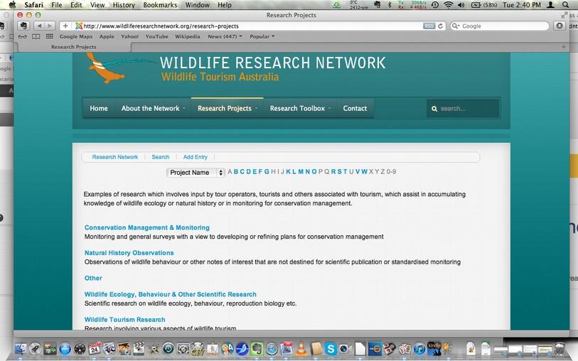
6 Last year, it was decided that a network of operators involved in research could benefi t from connecting with one another To discuss ideas, collaborate, complement one another's work, or avoid duplication. Subsequently, WTA has started a new website with the assistance of our new webmaster Robyn Stark,
7 This website includes details of wildlife research throughout Australia which involves; Tourism, either by operators with scientifi c background conducting research themselves, or operators, eco-lodges and wildlife parks respectively Offering free or discounted transport, accommodation or access to academic researchers. Involves tourists as volunteers in the science or as close observers to the science Links to books, identifi cation keys and useful equipment, as well as background information on 'citizen science,' 'voluntourism' and other related topics, and will soon introduce interactive forums.
8

9

10
11 Workshop session on developing this network 3.30 to 4.15 today
12 Can tour operators and tourists provide real value to scientific research and conservation monitoring? What are best case examples of this? What can tour operators, wildlife parks and eco-accommodation usefully offer to wildlife researchers? Is there be a danger of exploitation by researchers (including postgraduate students) and how do we safeguard against this? What kinds of guidelines should we develop for operators to ensure the science is good enough to gain the support of academics?
13 What are some of the tasks that could be usefully done by people with no scientific background or knowledge of local wildlife? Are there some higher-level tasks that more experienced volunteers could assist with? What kinds of safeguards should we have in place to check for accuracy of data collected? What kind of acknowledgment should be given to volunteer assistants? What information systems are needed to capture, store, and share this information?
14 Using GIS to help with wildlife tourism and biodiversity conservation This session is a discussion about the usefulness of Geographic Information Systems (GIS) for wildlife tourism managers. A GIS is a system designed to capture, store, manipulate, analyse, manage, and present all types of geographical data for informing decision making Understand the GIS process, and know what kinds of information is best contributed and utilised, and the limits to its effectiveness. Priorities for wildlife tourism related GIS will be identified, and effective options for addressing those priorities will be developed. Questions to be addressed include; What are the main conflicts between tourism and biodiversity conservation? What do we need to find out in order to make informed decisions as to where to allow various kinds of activities and structures? How can GIS assist this information-gathering? How much 'ground-truthing' is needed for different purposes? How can GIS most effectively be used for deciding which particular areas should be preserved as national parks or other conservation areas and which are more suited to active forms of recreation or accommodation?
WELCOME & INTRODUCTION
 MPA Management Capacity Building Training Module 1: WELCOME & INTRODUCTION Participants Distinguished Guests Welcome Site Overviews of MPAs represented Overview of Training Program What are Today s Objectives?
K-12 Partnership Lesson Plan
 K-12 Partnership Lesson Plan Overview Objectives Why fly south? How climate change alters the phenology of plants and animals The timing of recurring life cycle events for plants and animals, like flowering
Linking Tourism & Conservation
 Linking Tourism & Conservation Pasvik, October 14, 2014 Peter Prokosch 1 The Green Belt is an Important Part of the Global Protected Area Network 2 The CBD Aichi 2020 target 11 By 2020, at least 17 per
Community participation in sustainable tourism - A case study of two indigenous communities
 Po-Hsin Lai Department of Park, Recreation, and Tourism Sciences Texas A&M University Community participation in sustainable tourism - A case study of two indigenous communities Community participation
8 th Arctic Regional Hydrographic Commission Meeting September 2018, Longyearbyen, Svalbard Norway
 8 th Arctic Regional Hydrographic Commission Meeting 11-13 September 2018, Longyearbyen, Svalbard Norway Status Report of the Arctic Regional Marine Spatial Data Infrastructures Working Group (ARMSDIWG)
ACRONYMS AREAS COUNTRIES MARINE TERMS
 Natura 2000 ACRONYMS AREAS COUNTRIES MARINE TERMS DEFINITION A European network of protected sites under the European Habitats and Birds Directives, aiming to protect the most valuable and threatened European
TOWARDS CLIMATE-RESILIENT COASTAL MANAGEMENT: OPPORTUNITIES FOR IMPROVED ICZM IN BELIZE
 TOWARDS CLIMATE-RESILIENT COASTAL MANAGEMENT: OPPORTUNITIES FOR IMPROVED ICZM IN BELIZE CHANTALLE SAMUELS Coastal Zone Management Authority and Institute The Caribbean Community Climate Change Centre VULNERABILITY
Natura 2000 and spatial planning. Executive summary
 Natura 2000 and spatial planning Executive summary DISCLAIMER The information and views set out in this study are those of the author(s) and do not necessarily reflect the official opinion of the Commission.
Teacher s Resource Pack
 Teacher s Resource Pack Stage 4 & Stage 5 Geography Book your excursion today! Call (02) 8251 7801 Welcome to SEA LIFE Sydney Aquarium s Geography Student Resources Teacher Notes A trip to SEA LIFE Sydney
Your web browser (Safari 7) is out of date. For more security, comfort and. the best experience on this site: Update your browser Ignore
 is out of date. For more security, comfort and. the best experience on this site: Update your browser Ignore") Your web browser (Safari 7) is out of date. For more security, comfort and Activityengage the best experience on this site: Update your browser Ignore Introduction to GIS What is a geographic information
Your web browser (Safari 7) is out of date. For more security, comfort and Activityengage the best experience on this site: Update your browser Ignore Introduction to GIS What is a geographic information
1. Pass GE1101E Geographical Journeys: Exploring World Environments. This will be counted towards the Faculty Core or UE requirements.
 H Geography At the Department of Geography, students are encouraged to develop a deeper and more critical understanding of both physical and human environments. Students will acquire knowledge, skills
Outline National legislative & policy context Regional history with ESSIM ESSIM Evaluation Phase Government Integration via RCCOM Regional ICOM Framew
 What MSP Implementation could change in the Maritimes Region Tim Hall, Regional Manager Oceans and Coastal Management Division Ecosystem Management Branch Fisheries and Oceans Canada Maritimes Region BIO
Framework on reducing diffuse pollution from agriculture perspectives from catchment managers
 Framework on reducing diffuse pollution from agriculture perspectives from catchment managers Photo: River Eden catchment, Sim Reaney, Durham University Introduction This framework has arisen from a series
Cairngorms National Park Strategy and Action Plan for Sustainable Tourism Summary. Published by Cairngorms National Park Authority
 Cairngorms National Park Strategy and Action Plan for Sustainable Tourism 2011-2016 Summary Published by Cairngorms National Park Authority Cairngorms National Park Strategy and Action Plan for Sustainable
A Journey Back in Time
 A Trip Through Geologic Time TEACHER NOTES Lab zonetm A Journey Back in Time The following steps will walk you through the. Use the hints and detailed directions as you guide your students through planning,
THE GOVERNOR OF SVALBARD
 Human- Polar Bear conflict reduction workshop 2013 By Espen Stokke, Senior Adviser Nature Management THE GOVERNOR OF SVALBARD Topics Svalbard Environmental Protection Act - New rules on protection in the
* Population Dynamics
 * Population Dynamics Populations are dynamic constantly changing Some are seriously declining and threatened with extinction Others are experiencing growth Therefore biologists are constantly studying
GREEN GROWTH TOOLBOX. Nature-Friendly Planning. Jeff Marcus North Carolina Wildlife Resources Commission
 GREEN GROWTH TOOLBOX Nature-Friendly Planning Jeff Marcus North Carolina Wildlife Resources Commission Growth in North Carolina NC is the 5 th fastest growing state 3 million people will move to NC over
IUCN Red List Process. Cormack Gates Keith Aune
 IUCN Red List Process Cormack Gates Keith Aune The IUCN Red List Categories and Criteria have several specific aims to provide a system that can be applied consistently by different people; to improve
Greenland: Balancing the need for development and environmental protection. Arctic Frontiers 2016 Industry and Environment
 Greenland: Balancing the need for development and environmental protection Arctic Frontiers 2016 Industry and Environment Speech by Minister for Finance, Mineral Resources and Foreign Affairs Mr. Vittus
Citizen Science and Arctic Observing: Using the Internet and Simple Technologies to Improve Understanding of Arctic Ecosystem Change
 Citizen Science and Arctic Observing: Using the Internet and Simple Technologies to Improve Understanding of Arctic Ecosystem Change Maribeth S. Murray 1, Phillip A. Loring 2, Howard Ferren 3 and Rebekka
Haida Gwaii Queen Charlotte Islands
 Haida Gwaii Queen Charlotte Islands H E R I T A G E T O U R I S M STRATE GY January 2003 Haida Gwaii/Queen Charlotte Islands Heritage Tourism Strategy Working Group The Haida Gwaii/Queen Charlotte Islands
Cross-border Maritime Spatial Plan for the Black sea - Romania and Bulgaria project
 Cross-border Maritime Spatial Plan for the Black sea - Romania and Bulgaria project in Romania and Bulgaria Plan Presentation A first step in the management of the marine areas of Romania and Bulgaria
Terms of Reference for the Comparative Environmental Review (CER) of. Options for the Mactaquac Project, Mactaquac, New Brunswick
 of. Options for the Mactaquac Project, Mactaquac, New Brunswick") Terms of Reference for the Comparative Environmental Review (CER) of Options for the Mactaquac Project, Mactaquac, New Brunswick Preamble The New Brunswick Power Corporation ( NB Power ) operates the Mactaquac
Terms of Reference for the Comparative Environmental Review (CER) of Options for the Mactaquac Project, Mactaquac, New Brunswick Preamble The New Brunswick Power Corporation ( NB Power ) operates the Mactaquac
Aboriginal communities strengthen governance with location-based tools in the 21st century
 Aboriginal communities strengthen governance with location-based tools in the 21st century Today, Aboriginal communities are taking advantage of the geomatics technologies that underpin popular online
Chapter 1: Introduction to Safety and Ethics
 Core Curriculum Standards Met by Each Chapter On the Right Trail meets Utah s Social Studies Core Curriculum Standards for grades 3-7. Each chapter has specific standard objectives, which are met by the
What Can Citizen Scientists Tell Us about Drought?
 What Can Citizen Scientists Tell Us about Drought? Amanda Brennan, Kirstin Dow, Benjamin Haywood, Kirsten Lackstrom American Meteorological Society Annual Meeting January 13, 2016 New Orleans, LA Today
HELSINKI COMMISSION Baltic Marine Environment Protection Commission
 HELSINKI COMMISSION Baltic Marine Environment Protection Commission HELCOM RECOMMENDATION 24/10 Adopted 25 June 2003, having regard to Article 20, Paragraph 1 b) of the 1992 Helsinki Convention IMPLEMENTATION
PACIFIC ISLANDS REGIONAL OCEAN POLICY. A healthy Ocean that sustains the livelihoods and aspirations of Pacific Island communities.
 PACIFIC ISLANDS REGIONAL OCEAN POLICY VISION A healthy Ocean that sustains the livelihoods and aspirations of Pacific Island communities. THIS IS OUR OCEAN 1. The care of the ocean is the responsibility
CHAPTER 22 GEOGRAPHIC INFORMATION SYSTEMS
 CHAPTER 22 GEOGRAPHIC INFORMATION SYSTEMS PURPOSE: This chapter establishes the administration and use of to improve the quality and accessibility of Department s spatial information and support graphical
PYP of the IB: Program of Inquiry. An inquiry into: An inquiry into How we express ourselves. An inquiry into How the world works
 PYP of the IB: Program of Inquiry School: Center for Inquiry at School #2 2010-2011 : Age the nature of orientation in and time; personal the the ways in the natural the the rights K Safe and Healthy Central
Policy framework The Netherlands and the Polar Regions, Summary and priorities
 Policy framework The Netherlands and the Polar Regions, 2011-2015 Summary and priorities The policy outlined in this Policy Framework for the Polar Regions (2011-2015) is part of the government s orientation
Copernicus Relays. Roles and responsibilities of the Copernicus Relays. user uptake
 Copernicus Relays user uptake Roles and responsibilities of the Copernicus Relays The European Commission has launched two Networks, the Copernicus Relays and the Copernicus Academy, to contribute to spreading
The Future of Tourism in Antarctica: Challenges for Sustainability
 The Future of Tourism in Antarctica: Challenges for Sustainability Machiel Lamers Thesis summary In the last decade, Antarctic tourism has grown rapidly both in terms of volume and diversity. This growth
3D Laser Scanning for Digital Preservation and Dissemination of Cultural Heritage
 3D Laser Scanning for Digital Preservation and Dissemination of Cultural Heritage Main scanned objects - Four Temples of Different Religions in Sofia Eng. Zlatan Zlatanov, Eng. Milush Blagoev, Irina Nikoevska
Ministry of Health and Long-Term Care Geographic Information System (GIS) Strategy An Overview of the Strategy Implementation Plan November 2009
 Strategy An Overview of the Strategy Implementation Plan November 2009") Ministry of Health and Long-Term Care Geographic Information System (GIS) Strategy An Overview of the Strategy Implementation Plan November 2009 John Hill, Health Analytics Branch Health System Information
Ministry of Health and Long-Term Care Geographic Information System (GIS) Strategy An Overview of the Strategy Implementation Plan November 2009 John Hill, Health Analytics Branch Health System Information
Resolution XIII.23. Wetlands in the Arctic and sub-arctic
 13th Meeting of the Conference of the Contracting Parties to the Ramsar Convention on Wetlands Wetlands for a Sustainable Urban Future Dubai, United Arab Emirates, 21-29 October 2018 Resolution XIII.23
Economic Benefit Study on Value of Spatial Information Australian Experience
 Economic Benefit Study on Value of Spatial Information Australian Experience Dr Zaffar Sadiq Mohamed-Ghouse Director, International Relations Cooperative Research Centre for Spatial Information zsadiq@crcsi.com.au
SPLAN-Natura Towards an integrated spatial planning approach for Natura th January, 2017 Brussels. Commissioned by DG Environment
 SPLAN-Natura 2000 Towards an integrated spatial planning approach for Natura 2000 Commissioned by DG Environment 17 th January, 2017 Brussels V. Simeonova (Ph.D.) Drivers towards integrating Biodiversity
Walworth Primary School
 Walworth Primary School Date: April 2016 Revision Due: April 2017 Ref: L.Smith Geography Policy 1 Geography Policy Introduction A high quality geography education should inspire in pupils a curiosity and
Cycles, Systems and Changing Places 5 days
 AS Level Geography AQA Cycles, Systems and Changing Places 5 days Complete the fieldwork requirements for AS level students within physical and human environments. Fieldwork in these locations provides
Hydrologic Analysis for Ecosystem Restoration
 Hydrologic Analysis for Ecosystem Restoration Davis, California Objectives: To provide participants with: 1) an understanding of the issues in restoration studies; 2) an overview of Corps policies and
An Introduction to Day Two. Linking Conservation and Transportation Planning Lakewood, Colorado August 15-16, 16, 2006
 An Introduction to Day Two Linking Conservation and Transportation Planning Lakewood, Colorado August 15-16, 16, 2006 1 Agenda Day One Transportation Planning Heritage Program State Wildlife Action Plan
Measuring the Economic Impact of Tourism on Cities. Professor Bruce Prideaux James Cook University Australia
 Measuring the Economic Impact of Tourism on Cities Professor Bruce Prideaux James Cook University Australia Outline of Presentation Aim and scope Methodology Current range of indicators The way forward
Natural Resource Management. Northern Tasmania. Strategy. Appendix 2
 Natural Resource Management Strategy Northern Tasmania 2015 2020 Appendix 2 Appendix 2 Appendix 2. Carbon Planting Spatial Prioritisation In support of this Strategy s development and implementation, work
CLLD Cooperation OFFER
 Title of the proposed project (English) CLLD Cooperation OFFER PARKS PROTECTION III - Management, Protection and Economic Development in Protected Areas Type of project (select as many as you want) Cooperation
Content Area: Social Studies Standard: 1. History Prepared Graduates: Develop an understanding of how people view, construct, and interpret history
 Standard: 1. History Develop an understanding of how people view, construct, and interpret history 1. Organize and sequence events to understand the concepts of chronology and cause and effect in the history
ICSM delivering benefits through collaboration
 ICSM delivering benefits through collaboration Russell Priebbenow Chair and Queensland Member Australia and New Zealand s Intergovernmental Committee on Surveying and Mapping Overview Who is ICSM & why
Coastal Guide ICZM Information System
 Coastal Guide ICZM Information System 1. Key data Project title: Implementing alternative strategies in Irish beach and dune management: involvement in sustainable coastal development Country: Ireland
Maritime Spatial Planning Framework Directive Supported by INSPIRE
 Maritime Spatial Planning Framework Directive Supported by INSPIRE Andrej Abramić, Vanda Nunes de Lima, Paul Smits, Emanuele Bigagli, Chris Schubert European Commission Joint Research Centre Institute
THE SEVILLE STRATEGY ON BIOSPHERE RESERVES
 THE SEVILLE STRATEGY ON BIOSPHERE RESERVES 1 VISION FOR BIOSPHERE RESERVES IN THE 21 ST CENTURY The international Seville Conference on Biosphere Reserves, organised by UNESCO, adopted a two-pronged approach,
Oak Ridge Environmental Information System (OREIS): Formalizing the Shapes of Things on the Oak Ridge Reservation 15393
: Formalizing the Shapes of Things on the Oak Ridge Reservation 15393") Oak Ridge Environmental Information System (OREIS): Formalizing the Shapes of Things on the Oak Ridge Reservation 15393 Patricia J. Halsey, Lacey Wicks (OREM Summer Intern) U.S. Department of Energy Peter
Oak Ridge Environmental Information System (OREIS): Formalizing the Shapes of Things on the Oak Ridge Reservation 15393 Patricia J. Halsey, Lacey Wicks (OREM Summer Intern) U.S. Department of Energy Peter
Restoring Rivers in Cumbria Online Story Map of a case study on the River Lyvennet
 Restoring Rivers in Cumbria Online Story Map of a case study on the River Lyvennet Summary This Story Map presents a river restoration case study for the River Eden Catchment, Cumbria. Students can learn
Supporting movement patterns research with qualitative sociological methods gps tracks and focus group interviews. M. Rzeszewski, J.
 Supporting movement patterns research with qualitative sociological methods gps tracks and focus group interviews M. Rzeszewski, J. Kotus Adam Mickiewicz University, ul. Dziegielowa 27, 61-680 Poznan,
The Thresholds working Group.
 A Report for the CEESP on the Key Biodiversity Areas (KBA) Delineation Workshop organized by the IUCN during 10-15 March 2013, Front Royal, Virginia, USA. The joint task force of the World Commission of
ISLAND RESCUE A PLAN FOR THE CONSERVATION AND SUSTAINABLE USE OF AUSTRALIA S ISLANDS DEREK BALL
 ISLAND RESCUE A PLAN FOR THE CONSERVATION AND SUSTAINABLE USE OF AUSTRALIA S ISLANDS DEREK BALL CONTEXT TIMES CHANGE OUR TRAJECTORY OUR TRAJECTORY Declines overwhelmingly dominate species trends 606 (72%)
Dr Ozlem Adiyaman Earth Sciences and Geo-hazards Risk Reduction Section Division of Ecological and Earth Sciences ( ) NATURAL SCIENCES
 NATURAL SCIENCES") Earth Sciences and Geo-hazards Risk Reduction Section Earth observation with COPERNICUS to : protect, monitor, document, present and share our common heritage, our cultural and natural UNESCO World Heritage
Earth Sciences and Geo-hazards Risk Reduction Section Earth observation with COPERNICUS to : protect, monitor, document, present and share our common heritage, our cultural and natural UNESCO World Heritage
ENV208/ENV508 Applied GIS. Week 1: What is GIS?
 ENV208/ENV508 Applied GIS Week 1: What is GIS? 1 WHAT IS GIS? A GIS integrates hardware, software, and data for capturing, managing, analyzing, and displaying all forms of geographically referenced information.
Expanding Canada s Rail Network to Meet the Challenges of the Future
 Expanding Canada s Rail Network to Meet the Challenges of the Future Lesson Overview Rail may become a more popular mode of transportation in the future due to increased population, higher energy costs,
Project no 12/72 - Final Rapport
 flssncialinn ui Armin Exneditiun Bruise flueralurs l B u @ Project no 12/72 - Final Rapport Boot, clothing and equipment decontamination program Background In 2010 AECO applied and received money from
Dublin City Schools Social Studies Graded Course of Study Grade 5 K-12 Social Studies Vision
 K-12 Social Studies Vision The Dublin City Schools K-12 Social Studies Education will provide many learning opportunities that will help students to: develop thinking as educated citizens who seek to understand
WHERE THE MONEY COME FROM? ECONNECT project is financed with ,00 by
 THE STARTING POINT WHERE THE MONEY COME FROM? ECONNECT project is financed with 3.198.240,00 by WHO? The partnership is composed by 16 partners: AUSTRIA -University of Veterinary Medicine of Vienna Research
Sustainable tourism in for Sustaibale Danang
 Sustainable tourism in for Sustaibale Danang A case study of Balearic Ecotax in Spain toward Sustainable tourism Miki Yoshizumi Associate Professor College of Gastronomy Management Ritsumeikan University
Contents Research Objects, Tasks and Historical Development of Tourism Earth-science Role of Tourism Earth-science in Tourism Development
 Contents 1 Research Objects, Tasks and Historical Development of Tourism Earth-science.... 1 1.1 Research Objects of Tourism Earth-science.... 1 1.1.1 Definition of Tourism Earth-science... 1 1.1.2 Definition
Visitor Flows Model for Queensland a new approach
 Visitor Flows Model for Queensland a new approach Jason. van Paassen 1, Mark. Olsen 2 1 Parsons Brinckerhoff Australia Pty Ltd, Brisbane, QLD, Australia 2 Tourism Queensland, Brisbane, QLD, Australia 1
Council Workshop on Neighbourhoods Thursday, October 4 th, :00 to 4:00 p.m. Burlington Performing Arts Centre
 Council Workshop on Neighbourhoods Thursday, October 4 th, 2012 1:00 to 4:00 p.m. Burlington Performing Arts Centre Agenda Introductions Warm-Up Exercise Presentation Exercise Neighbourhood Planning Break
Florida Friendly Landscapes?
 Florida Friendly Landscapes? Backyards as Habitats Ecology Concepts Ecosystem interacting network of living and non-living components Community association of different species living and interacting in
IN Indiana Indiana Academic Standards
 IN Indiana Indiana Academic Standards Indiana Academic Standards for Grade 3 History Students describe how significant people, events and developments have shaped their own community and region; compare
Alleghany County Schools Curriculum Guide GRADE/COURSE: World Geography
 GRADE/COURSE: World 2013-14 GRADING PERIOD: 1 st Six Weeks Time Frame Unit/SOLs SOL # Strand Resource Assessment 8 days* The student will use maps, globes, satellite images, photographs, or diagrams to
MPA_Inventory_GIS_Database
 MPA_Inventory_GIS_Database Metadata also available as Frequently-anticipated questions: What does this data set describe? 1. How should this data set be cited? 2. What geographic area does the data set
University of North Carolina at Chapel Hill (UNC) & Universidad San Francisco de Quito (USFQ) A joint initiative & partnership
 & Universidad San Francisco de Quito (USFQ) A joint initiative & partnership") University of North Carolina at Chapel Hill (UNC) & Universidad San Francisco de Quito (USFQ) A joint initiative & partnership Carlos F. Mena, USFQ & Stephen J. Walsh, UNC Directors Carlos A. Valle, USFQ
University of North Carolina at Chapel Hill (UNC) & Universidad San Francisco de Quito (USFQ) A joint initiative & partnership Carlos F. Mena, USFQ & Stephen J. Walsh, UNC Directors Carlos A. Valle, USFQ
Multiple services provided by protected-areas in times of crises and implication for socio-ecological systems resilience
 Multiple services provided by protected-areas in times of crises and implication for socio-ecological systems resilience Insights from Hwange SES in Zimbabwe by Chloé Guerbois, Carli Bunding-Venter & Hervé
Fig 1. Steps in the EcoValue Project
 Assessing the Social and Economic Value of Ecosystem Services in the Northern Forest Region: A Geographic Information System (GIS) Approach to Landscape Valuation Principal Investigator(s): Dr. Matthew
Geographical knowledge and understanding scope and sequence: Foundation to Year 10
 Geographical knowledge and understanding scope and sequence: Foundation to Year 10 Foundation Year 1 Year 2 Year 3 Year 4 Year 5 Year 6 Year level focus People live in places Places have distinctive features
Climate Change: How it impacts Canadians and what we can do to slow it down.
 Climate Change: How it impacts Canadians and what we can do to slow it down. Lesson Overview This lesson takes stock of how climate change has already affected Canadians in geographic, economic, and cultural
Spatial Data Infrastructure Concepts and Components. Douglas Nebert U.S. Federal Geographic Data Committee Secretariat
 Spatial Data Infrastructure Concepts and Components Douglas Nebert U.S. Federal Geographic Data Committee Secretariat August 2009 What is a Spatial Data Infrastructure (SDI)? The SDI provides a basis for
Executive Summary and Recommendations
 ANNEX I: EXECUTIVE SUMMARY AND RECOMMENDATIONS OF THE 12RMSD TWELFTH REGIONAL MEETING OF THE METEOROLOGICAL SERVICE DIRECTORS 30 -JUNE to 6 -JULY 2007 Rarotonga, Cook Islands Executive Summary and Recommendations
An Ontology-based Framework for Modeling Movement on a Smart Campus
 An Ontology-based Framework for Modeling Movement on a Smart Campus Junchuan Fan 1, Kathleen Stewart 1 1 Department of Geographical and Sustainability Sciences, University of Iowa, Iowa City, IA, 52242,
GIS Visualization: A Library s Pursuit Towards Creative and Innovative Research
 GIS Visualization: A Library s Pursuit Towards Creative and Innovative Research Justin B. Sorensen J. Willard Marriott Library University of Utah justin.sorensen@utah.edu Abstract As emerging technologies
Matrix ranking: a means to discussion
 Matrix ranking: a means to discussion Stephany Kersten Introduction Matrix ranking was discussed by Simon Maxwell and Claude Bart in PLA Notes 22 (199) in terms of its numerical outcomes. However, they
World Geography. WG.1.1 Explain Earth s grid system and be able to locate places using degrees of latitude and longitude.
 Standard 1: The World in Spatial Terms Students will use maps, globes, atlases, and grid-referenced technologies, such as remote sensing, Geographic Information Systems (GIS), and Global Positioning Systems
Spatially Enabled Society
 International Seminar on Land Administration Trends and Issues in Asia and the Pacific Region Spatially Enabled Society Abbas Rajabifard Vice Chair PCGIAP-WG3 Vice-President (President Elect), GSDI Association
PROGRESS REPORT ON APPROACH PAPER THE IMPLEMENTATION OF THE GEF KNOWLEDGE MANAGEMENT. GEF/C.49/Inf.04 September 23, 2015
 49 th GEF Council Meeting October 20 22, 2015 Washington, D.C. GEF/C.49/Inf.04 September 23, 2015 PROGRESS REPORT ON THE IMPLEMENTATION OF THE GEF KNOWLEDGE MANAGEMENT APPROACH PAPER TABLE OF CONTENTS
School of Geography and Geosciences. Head of School Degree Programmes. Programme Requirements. Modules. Geography and Geosciences 5000 Level Modules
 School of Geography and Geosciences Head of School Degree Programmes Graduate Diploma: Dr W E Stephens Health Geography Research Environmental History and Policy (see School of History) M.Res.: M.Litt.:
Inquiry-based Curriculum Enhancement
 ICE Inquiry-based Curriculum Enhancement Lesson Plan: Species Interactions General Description This activity is designed to reinforce an understanding of basic concepts in ecology as well as the use of
Spatial Decision-Support for National Marine Conservation Areas in the Southern Strait of Georgia and Gwaii Haanas
 Spatial Decision-Support for National Marine Conservation Areas in the Southern Strait of Georgia and Gwaii Haanas Lindsay McBlane Krista Royle Greg MacMillan Photo: Mark Hiebert Western and Northern Service
State and National Standard Correlations NGS, NCGIA, ESRI, MCHE
 GEOGRAPHIC INFORMATION SYSTEMS (GIS) COURSE DESCRIPTION SS000044 (1 st or 2 nd Sem.) GEOGRAPHIC INFORMATION SYSTEMS (11, 12) ½ Unit Prerequisite: None This course is an introduction to Geographic Information
NSW Education Standards Authority. Geography Geography Life Skills Stage 6 Draft Directions for Syllabus Development
 NSW Education Standards Authority Geography Geography Life Skills Stage 6 Draft Directions for Syllabus Development for Consultation 23 July 2018 2 September 2018 2018 NSW Education Standards Authority
Through their research, geographers gather a great deal of data about Canada.
 Ecozones What is an Ecozone? Through their research, geographers gather a great deal of data about Canada. To make sense of this information, they often organize and group areas with similar features.
Designing Networks of Marine Protected Areas in DFO s Three Atlantic Bioregions
 Designing Networks of Marine Protected Areas in DFO s Three Atlantic Bioregions Presentation for Indigenous Protected Areas Workshop Max Westhead, DFO and Adrian Gerhartz-Abraham, Dalhousie March 29, 2017
Geo-Enabling Mountain Bike Trail Maintenance:
 Title Slide Geo-Enabling Mountain Bike Trail Maintenance: Enhanced Stewardship of the Fountainhead Mountain Bike Trail through GIS Technology Ruthann Ligon Follow the Trail Fountainhead Mountain Bike
Nebraska Core Academic Content Standards Science Grade: 2 - Adopted: 2010
 Main Criteria: Nebraska Core Academic Content Standards Secondary Criteria: Subjects: Science, Social Studies Grade: 2 Correlation Options: Show Correlated Nebraska Core Academic Content Standards Science
Conserving freshwater ecosystem values in Tasmania, Australia: identification and application of freshwater conservation management priority areas
 Conserving freshwater ecosystem values in Tasmania, Australia: identification and application of freshwater conservation management priority areas Danielle Hardie 1 and Peter Davies 2 1 Department of Primary
Measure of Design Thinking-based Regional Innovation: Focusing on Gamcheon Culture Village
 , pp.125-129 http://dx.doi.org/10.14257/astl.2017.143.26 Measure of Design Thinking-based Regional Innovation: Focusing on Gamcheon Culture Village Na-Rang Kim 1, Soon-Goo Hong 1*, Sang-Jin Lee 2 1 Dong-A
United States Department of the Interior NATIONAL PARK SERVICE Northeast Region
 United States Department of the Interior NATIONAL PARK SERVICE Northeast Region June 17, 2017 REQUEST FOR STATEMENTS OF INTEREST and QUALIFICATIONS Project Title: ASSESSMENT OF NATURAL RESOURCE CONDITION
Curriculum Links AS and A level Field Studies
 Equipment Includes Human Geography Coastal Management Students examine the conflicts that arise from coastal erosion and the options for coastal management. They investigate different types of coastal
NORTH VANCOUVER ISLAND MARINE PLAN: OVERVIEW 2015
 NORTH VANCOUVER ISLAND MARINE PLAN: OVERVIEW 2015 North Vancouver Island Marine Plan Overview Refers to: Marine Planning Partnership Initiative. 2015. North Vancouver Island Marine Plan. Copyright 2015
Key elements An open-ended questionnaire can be used (see Quinn 2001).
.") Tool Name: Risk Indexing What is it? Risk indexing is a systematic approach to identify, classify, and order sources of risk and to examine differences in risk perception. What can it be used assessing
Tool Name: Risk Indexing What is it? Risk indexing is a systematic approach to identify, classify, and order sources of risk and to examine differences in risk perception. What can it be used assessing
The Establishment of a Database on Current Research in UNESCO Biosphere Reserves: Limitations and Opportunities
 The Establishment of a Database on Current Research in UNESCO Biosphere Reserves: Limitations and Opportunities Pamela Shaw a* Martin F. Price b Taylor Alexander a Rushi Gadoya a Graham Sakaki a Lauren