VALUE OF GEOSPATIAL TECHNOLOGY IN BOOSTING OMAN S ECONOMY
|
|
|
- Silvia Simmons
- 5 years ago
- Views:
Transcription


1 VALUE OF GEOSPATIAL TECHNOLOGY IN BOOSTING OMAN S ECONOMY RESEARCH REPORT KEY FINDINGS Kuhelee Chandel Senior Research Analyst Geospatial Media and communications
2 OUTLINE Oman Today & Tomorrow, Transformative Scenarios Future Trends of Geospatial Technology Applications in Oman Recommendation for the Future
3 OMAN TODAY & TOMORROW, TRANSFORMATIVE SCENARIOS

4 Incremental Value of Stakeholders in Geospatial Value Addition to the Economy
5 INTRODUCTION To evaluate the present and to define the way forward, the research study assesses Oman s geospatial ecosystem in the following four parameters: Geospatial Data Infrastructure and Policy Framework Institutional Capacity Industry Fabric User Adoption Level
6 GEOSPATIAL DATA INFRASTRUCTURE & POLICY FRAMEWORK + STRENGTHS More openness from government data providers Procuring data takes 6 months Spatial data has been transferred into digital format Quality levels of geospatial data are well-defined National Continuously Operational Reference Station Network (OMANCORSNET) established - WEAKNESS Organizations contributing to ONSDI do not adhere to common standards and technical specifications Process of accessing data is manually driven Lack of public-private engagement
7 + STRENGTHS INSTITUTIONAL CAPACITY Inclusive geospatial programs in schools and university curriculums More opportunities of geospatial training for teachers Educational universities like Sultan Qaboos University are involved in national geospatial projects like coastal erosion projects, water quality, etc. Induction programs that lead to employment by NSA - WEAKNESS Students don t want to be geospatialists but engineers Value addition of geospatial education not recognized Job ready students from universities is a challenge
8 INDUSTRY FABRIC + STRENGTHS Collaboration with foreign geospatial industry players Presence of geospatial consultants who understand the culturally different industry of Oman Service Oriented geospatial industry Geospatial use active in workflows - WEAKNESS Not a well-established geospatial industry ecosystem Mostly outsource their products (data/content) and services from foreign countries Economic slow-down has resulted in negligible fund allocation for geospatial projects Lack of public-private partnerships Adoption of new geospatial technology is slow and user community is still dependant on traditional methods and data

9 USER ADOPTION LEVEL The real-value of technology is assessed on how and to what level it is being implemented by the end user. Significant users of Geospatial Technology and Information in Oman


10 Work based on Geospatial Technology/Information
11 Services offered by Geo-Division of Users

12 Beneficiaries of the Benefits arising from use of Geospatial Technology
13 Types of Geospatial Technology/Information Used

14 Popular Data Sources for Geospatial Information


15 Satisfaction Level w.r.t Return On Investment (ROI)
16 Challenges faced by users with respect to Standards
17 USER ADOPTION LEVEL + STRENGTHS ONSDI is gaining traction as the data source for spatial data NSA remains as the most important data source for most users Return on Investment is the major benefit derived from use of geospatial technology Geospatial technology is being integrated into everyday workflow management - WEAKNESS Lack of unified data standards Lack of supportive policies Dependency on traditional methods Lack of complete and interoperable data

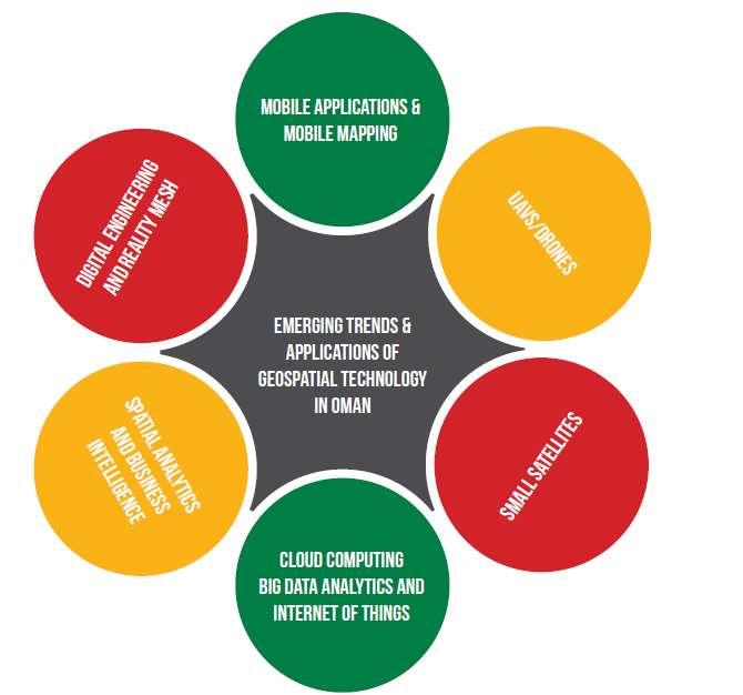
18 FUTURE TRENDS OF GEOSPATIAL TECHNOLOGY APPLICATIONS IN OMAN
19
20 RECOMMENDATION FOR THE FUTURE

21 Desired Salient Features of a National Geospatial Policy
22 THANK YOU
Oman NSDI Business Values and Future Directions. Hassan Alawi Alghazali Acting Director General National Spatial Data Infrastructure
 Oman NSDI Business Values and Future Directions Hassan Alawi Alghazali Acting Director General National Spatial Data Infrastructure Presentation Outline Geospatial Maturity Current Challenges NCSI s Role
Oman NSDI Supporting Economic Development. Saud Al-Nofli Director of Spatial Data Directorate General of NSDI, NCSI
 Oman NSDI Supporting Economic Development 2017 Saud Al-Nofli Director of Spatial Data Directorate General of NSDI, NCSI "It s critical to make correct decisions the first time to optimize the Investments
Implementing the Sustainable Development Goals: The Role of Geospatial Technology and Innovation
 Fifth High Level Forum on UN Global Geospatial Information Management Implementing the Sustainable Development Goals: The Role of Geospatial Technology and Innovation 28-30 November 2017 Sheraton Maria
Joanne N. Halls, PhD Dept. of Geography & Geology David Kirk Information Technology Services
 Joanne N. Halls, PhD Dept. of Geography & Geology David Kirk Information Technology Services Geographic Information Systems manage and analyze data to solve spatial problems. Real World Abstraction Analysis
THE ROLE OF GEOSPATIAL AT THE WORLD BANK
 THE ROLE OF GEOSPATIAL AT THE WORLD BANK INSPIRE Conference Barcelona, Spain September 26, 2016 Kathrine Kelm Senior Land Administration Specialist Global Land and Geospatial Unit The World Bank Group
Ministry of Health and Long-Term Care Geographic Information System (GIS) Strategy An Overview of the Strategy Implementation Plan November 2009
 Strategy An Overview of the Strategy Implementation Plan November 2009") Ministry of Health and Long-Term Care Geographic Information System (GIS) Strategy An Overview of the Strategy Implementation Plan November 2009 John Hill, Health Analytics Branch Health System Information
Ministry of Health and Long-Term Care Geographic Information System (GIS) Strategy An Overview of the Strategy Implementation Plan November 2009 John Hill, Health Analytics Branch Health System Information
2018/1 The integration of statistical and geospatial information. The Regional Committee of UN-GGIM: Americas:
 The following are the conclusions and recommendations of the Regional Committee of the United Nations on Global Geospatial Information Management for the Americas, during its Fifth Session, Thursday 8
UN-GGIM: Strengthening Geospatial Capability
 Fifth Plenary Meeting of UN-GGIM: Europe Brussels, 6-7 June 2018 UN-GGIM: Strengthening Geospatial Capability Walking the talk to leave no one behind Greg Scott, UN-GGIM Secretariat Environmental Statistics
Land Use in the context of sustainable, smart and inclusive growth
 Land Use in the context of sustainable, smart and inclusive growth François Salgé Ministry of sustainable development France facilitator EUROGI vice president AFIGéO board member 1 Introduction e-content+
BRIDGING THE GEOSPATIAL DIGITAL DIVIDE: WORLD BANK-UNGGIM PARTNERSHIP
 BRIDGING THE GEOSPATIAL DIGITAL DIVIDE: WORLD BANK-UNGGIM PARTNERSHIP 5 TH HIGH LEVEL FORUM ON UNITED NATIONS GLOBAL GEOSPATIAL INFORMATION MANAGEMENT Mexico City, Mexico 28-30 November 2017 Kathrine Kelm
Challenges and Potentials of Place Based Information Management in Nepal"
 Nineteenth United Nations Regional Cartographic Conference for Asia and the Pacific, Bangkok, Thailand, 29 October 1 November 2012 Challenges and Potentials of Place Based Information Management in Nepal"
Statement of Mr. Sandagdorj Erdenebileg, Chief, Policy Development, Coordination, Monitoring and Reporting Service, UN-OHRLLS.
 Statement of Mr. Sandagdorj Erdenebileg, Chief, Policy Development, Coordination, Monitoring and Reporting Service, UN-OHRLLS at the Botswana National Workshop on the Vienna Programme of Action 27 th October
Open spatial data infrastructure
 Open spatial data infrastructure a backbone for digital government Thorben Hansen Geomatikkdagene 2018 Stavanger 13.-15. mars Spatial Data Infrastructure definition the technology, policies, standards,
The World Bank Local and Regional Competitiveness Project (P154263)
") Public Disclosure Authorized EUROPE AND CENTRAL ASIA Macedonia, former Yugoslav Republic of Finance, Competitiveness and Innovation Global Practice Recipient Executed Activities Investment Project Financing
Public Disclosure Authorized EUROPE AND CENTRAL ASIA Macedonia, former Yugoslav Republic of Finance, Competitiveness and Innovation Global Practice Recipient Executed Activities Investment Project Financing
Economic and Social Council
 United Nations Economic and Social Council Distr.: General 2 July 2012 E/C.20/2012/10/Add.1 Original: English Committee of Experts on Global Geospatial Information Management Second session New York, 13-15
Building a national spatial data infrastructure. Thorben Hansen, Head of Division Danish Agency for Data Supply and Efficiency
 Building a national spatial data infrastructure Thorben Hansen, Head of Division Danish Agency for Data Supply and Efficiency About Spatial Data Infrastructure Spatial data come from many sources and is
Aboriginal communities strengthen governance with location-based tools in the 21st century
 Aboriginal communities strengthen governance with location-based tools in the 21st century Today, Aboriginal communities are taking advantage of the geomatics technologies that underpin popular online
Faatasi Malologa (PGSC Chair) Director Department of Lands & Survey, Tuvalu
 Director Department of Lands & Survey, Tuvalu") Seventh Session of the United Nations Committee of Experts on Global Geospatial Information Management (UN-GGIM) - 31 July -4 August 2017 Faatasi Malologa (PGSC Chair) Director Department of Lands & Survey,
Seventh Session of the United Nations Committee of Experts on Global Geospatial Information Management (UN-GGIM) - 31 July -4 August 2017 Faatasi Malologa (PGSC Chair) Director Department of Lands & Survey,
By Daniel C. Edelson, PhD
 Your web browser (Safari 7) is out of date. For more security, comfort and the best experience on this site: Update your browser Ignore GEO - L ITERACY Preparation for Far-Reaching Decisions For the complete
Spatially Enabled Society
 International Seminar on Land Administration Trends and Issues in Asia and the Pacific Region Spatially Enabled Society Abbas Rajabifard Vice Chair PCGIAP-WG3 Vice-President (President Elect), GSDI Association
Arctic ecosystem services: TEEB Arctic Scoping study. Alexander Shestakov WWF Global Arctic Programme 3 December Arctic Biodiversity Congress
 Arctic ecosystem services: TEEB Arctic Scoping study Alexander Shestakov WWF Global Arctic Programme 3 December 20143 Arctic Biodiversity Congress Content 1. Project design 2. Approach 3. Challenges and
PROMOTING NATURE CONSERVATION AND SUSTAINABLE AGRICULTURAL DEVELOPMENT IN THE RURAL AREAS OF HONG KONG
 1 PROMOTING NATURE CONSERVATION AND SUSTAINABLE AGRICULTURAL DEVELOPMENT IN THE RURAL AREAS OF HONG KONG Director of Agriculture, Fisheries and Conservation Dr. LEUNG Siu-fai A STONE S THROW AWAY FROM
Non-Governmental Organizations for Spatial Data Infrastructure. Environmental Democracy Case
 Non-Governmental Organizations for Spatial Data Infrastructure Environmental Democracy Case L.Jovičić, S.Vrečar, V.Cetl, K.Ristovski GSDI Small Grant Program Award 2011-2012 Non-Governmental Organisations
Implementation of the ESPON 2020 cooperation program. 16 January 2017 Anneloes van Noordt
 Implementation of the ESPON 2020 cooperation program 16 January 2017 Anneloes van Noordt Outline! ESPON Cooperation Program! Specific Objectives! Applied Research! Targeted Analysis! Database & Tools!
What s the problem? A Modern Odyssey in Search of Relevance. The search for relevance. Some current drivers for new services. Some Major Applications
 A Modern Odyssey in Search of Relevance FIG Working Week, Athens, 24 May 2004 Paul Kelly ANZLIC Executive Director The search for relevance 1. New expectations for spatial services 2. Are we ready to meet
An online data and consulting resource of THE UNIVERSITY OF TOLEDO THE JACK FORD URBAN AFFAIRS CENTER
 An online data and consulting resource of THE JACK FORD URBAN AFFAIRS CENTER THE CENTER FOR GEOGRAPHIC INFORMATION SCIENCE AND APPLIED GEOGRAPHICS DEPARTMENT OF GEOGRAPHY AND PLANNING THE UNIVERSITY OF
WELCOME & INTRODUCTION
 MPA Management Capacity Building Training Module 1: WELCOME & INTRODUCTION Participants Distinguished Guests Welcome Site Overviews of MPAs represented Overview of Training Program What are Today s Objectives?
NSDI as a tool for Secure land tenure
 NSDI as a tool for Secure land tenure General Overview To look at the progress in SDI development and its application in policy formulation and impact on land tenure. INTEGRATION OF INFORMATION POLICIES
TOWARDS STRATEGIC SPATIAL PLANNING IN JAMAICA: THE NATIONAL SPATIAL PLAN
 TOWARDS STRATEGIC SPATIAL PLANNING IN JAMAICA: THE NATIONAL SPATIAL PLAN JIEP 5th Biennial Conference on the Environment: Balancing National Development and Environmental Protection June 6, 2011 Jamaica
The World Bank Local and Regional Competitiveness Project (P154263)
") Public Disclosure Authorized EUROPE AND CENTRAL ASIA Macedonia, former Yugoslav Republic of Trade & Competitiveness Global Practice Recipient Executed Activities Investment Project Financing FY 2016 Seq
Public Disclosure Authorized EUROPE AND CENTRAL ASIA Macedonia, former Yugoslav Republic of Trade & Competitiveness Global Practice Recipient Executed Activities Investment Project Financing FY 2016 Seq
Concept note. High-Level Seminar: Accelerating Sustainable Energy for All in Landlocked Developing Countries through Innovative Partnerships
 Concept note High-Level Seminar: Accelerating Sustainable Energy for All in Landlocked Developing Countries through Innovative Partnerships Date: 24 and 25 October 2016 Venue: Conference Room C3, Vienna
INSPIRE Basics. Vlado Cetl European Commission Joint Research Centre. https://ec.europa.eu/jrc/
 INSPIRE Basics Vlado Cetl European Commission Joint Research Centre https://ec.europa.eu/jrc/ Serving society Stimulating innovation Supporting legislation Outline SDI? Why European SDI? INSPIRE Policy
Outline National legislative & policy context Regional history with ESSIM ESSIM Evaluation Phase Government Integration via RCCOM Regional ICOM Framew
 What MSP Implementation could change in the Maritimes Region Tim Hall, Regional Manager Oceans and Coastal Management Division Ecosystem Management Branch Fisheries and Oceans Canada Maritimes Region BIO
GIS Education Activities in Detroit Public Schools Preparing Students for Careers in the Geospatial Industry A Multi-Agency Collaboration
 GIS Education Activities in Detroit Public Schools Preparing Students for Careers in the Geospatial Industry A Multi-Agency Collaboration Marsha A. Lewis, Social Studies Curriculum Specialist, Detroit
Bhutan: FCPF Readiness Grant FCPFR - FOREST CARBON PARTNERSHIP FACILITY
 Assignment: TF019030 Bhutan: FCPF Readiness Grant FCPFR - FOREST CARBON PARTNERSHIP FACILITY Task Team Leader: 00000290015 Approving Manager: 00000082671 - Dora Nsuwa Cudjoe - Kseniya Lvovsky Summary Information
PART A Project summary
 PART A Project summary A.1 Project identification Project title Project acronym Name of the lead partner organisation in English Specific objective Demonstrattion AF DAF Partner 1.1. Improving innovation
Briefing. H.E. Mr. Gyan Chandra Acharya
 Briefing by H.E. Mr. Gyan Chandra Acharya Under-Secretary-General and High Representative for the Least Developed Countries, Landlocked Developing Countries and Small Island Developing States Briefing
Pacific Geospatial and Surveying Council (PGSC) Geospatial and GNSS CORS Infrastructure Forum. Kuala Lumpur October
 Geospatial and GNSS CORS Infrastructure Forum. Kuala Lumpur October") Pacific Geospatial and Surveying Council (PGSC) Geospatial and GNSS CORS Infrastructure Forum. Kuala Lumpur 16-17 October Beginning and Progress Members PGSC Charter PGSC Strategy 2017-2027 Meetings Geodetic
Pacific Geospatial and Surveying Council (PGSC) Geospatial and GNSS CORS Infrastructure Forum. Kuala Lumpur 16-17 October Beginning and Progress Members PGSC Charter PGSC Strategy 2017-2027 Meetings Geodetic
Key Indicators for Territorial Cohesion & Spatial Planning Stakeholder Workshop - Project Update. 13 th December 2012 San Sebastián, Basque Country
 Key Indicators for Territorial Cohesion & Spatial Planning Stakeholder Workshop - Project Update 13 th December 2012 San Sebastián, Basque Country Key Aims Explore the use of territorial data in developing
Public Disclosure Copy
 Public Disclosure Authorized AFRICA Malawi Transport & Digital Development Global Practice IBRD/IDA Investment Project Financing FY 2017 Seq No: 2 ARCHIVED on 23-May-2018 ISR32537 Implementing Agencies:
CONFERENCE STATEMENT
 Final draft CONFERENCE STATEMENT We, the elected representatives of Canada, Denmark/Greenland, the European Parliament, Finland, Iceland, Norway, Russia, Sweden and the United States of America; In collaboration
Economic Benefit Study on Value of Spatial Information Australian Experience
 Economic Benefit Study on Value of Spatial Information Australian Experience Dr Zaffar Sadiq Mohamed-Ghouse Director, International Relations Cooperative Research Centre for Spatial Information zsadiq@crcsi.com.au
Outline. Tourism A Viable Option for Abandoned Mines?
 Tourism A Viable Option for Abandoned Mines? Pete Whitbread-Abrutat Post-Mining Alliance, Eden Project Outline Post-Mining Alliance Mining and tourism Aspects of mining and tourism Case studies Success
Integration for Informed Decision Making
 Geospatial and Statistics Policy Intervention: Integration for Informed Decision Making Greg Scott Global Geospatial Information Management United Nations Statistics Division Department of Economic and
Agenda Item B /20 Strategic Budget Development Phase I Preliminary Recommendations
 Agenda Item B-24 2019/20 Strategic Budget Development Phase I Preliminary Recommendations Board of Education February 13, 2019 2 Outline Preliminary Recommendations and Discussions School Staffing School
Spatial Data Availability Energizes Florida s Citizens
 NASCIO 2016 Recognition Awards Nomination Spatial Data Availability Energizes Florida s Citizens State of Florida Agency for State Technology & Department of Environmental Protection Category: ICT Innovations
PUBLIC HEALTH ASSOCIATION OF AUSTRALIA Strategic Plan
 PUBLIC HEALTH ASSOCIATION OF AUSTRALIA Strategic Plan March 2017 20 Napier Close Deakin ACT Australia 2600 PO Box 319 Curtin ACT Australia 2605 Table of Contents Introduction... 2 Vision for a healthy
Copernicus Academy. Roles and responsibilities of the Copernicus Academy. user uptake. Focus Data uptake, capacity building and skills development
 Copernicus Academy user uptake Roles and responsibilities of the Copernicus Academy The European Commission has launched two Networks, the Copernicus Relays and the Copernicus Academy, to contribute on
Spatial Big Data. Amol G. Deshmukh Geomatics Specialist
 6% Spatial Big Data Amol G. Deshmukh Geomatics Specialist % Everyone talks about it, nobody really knows how to use it, everyone thinks everyone else is using it, so everyone claims they are using it...
The Integrated Ge spatial Information Framework to the strengthening of NSDI, Mongolia
 Young Geospatial Professionals Summit 21 NOV 2018 The Integrated Ge spatial Information Framework to the strengthening of NSDI, Mongolia BAYARMAA ENKHTUR Geospatial information and technology department
JOB DESCRIPTION. Research Associate - Urban Economy and Employment
 JOB DESCRIPTION Research Associate - Urban Economy and Employment 2 Research Associate Urban Economy and Employment About Us The Indian Institute for Human Settlements (IIHS) is a national education institution
KUNMING FORUM ON UNITED NATIONS GLOBAL GEOSPATIAL INFORMATION MANAGEMENT CITIES OF THE FUTURE: SMART, RESILIENT
 KUNMING FORUM ON UNITED NATIONS GLOBAL GEOSPATIAL INFORMATION MANAGEMENT CITIES OF THE FUTURE: SMART, RESILIENT and SUSTAINABLE Yunnan Zhenzhuang Guest House, Kunming, China 10 12 May 2017 BACKGROUND CONCEPT
The future of SDIs. Ian Masser
 The future of SDIs Ian Masser Presentation Considers two questions relating to the future development of SDIs throughout the world Where have we got to now? Where should we go from here? Identifies four
Putting the U.S. Geospatial Services Industry On the Map
 Putting the U.S. Geospatial Services Industry On the Map December 2012 Definition of geospatial services and the focus of this economic study Geospatial services Geospatial services industry Allow consumers,
West-Estonian Archipelago Biosphere Reserve and Lima Action Plan
 West-Estonian Archipelago Biosphere Reserve and Lima Action Plan Lia Rosenberg, BR co ordinaator Toomas Kokovkin, MAB Focal Point ESTONIA 15.03.2016 LIMA Location on the globe and Europe The West-Estonian
Entrepreneurship on islands and other peripheral regions. Specific Contract No 6511 implementing Framework contract No CDR/DE/16/2015/
 Entrepreneurship on islands and other peripheral regions Specific Contract No 6511 implementing Framework contract No CDR/DE/16/2015/ Aims of this study: To analyse the particular challenges and obstacles
SCORE. INSPIRE-ing VOLUNTEERED GEOGRAPHIC INFORMATION: CASES FROM SOUTH EAST EUROPE. mashing up community and spatial technology
 mashing up community and spatial technology INSPIRE-ing VOLUNTEERED GEOGRAPHIC INFORMATION: CASES FROM SOUTH EAST EUROPE Spatial Consulting and Research Group integrating geospatial and organizational
Spatial Data Infrastructure in the Pacific
 Spatial Data Infrastructure in the Pacific. Sachindra Singh Senior Geospatial Systems Architect ICT for Development, Geoscience Division Pacific Community (SPC) OrganisationalBackground SPC - The Pacific
16540/14 EE/cm 1 DG E 1A
 Council of the European Union Brussels, 5 December 2014 (OR. en) 16540/14 ENV 965 CULT 139 NOTE From: To: Subject: General Secretariat of the Council Delegations Charter of Rome on Natural and Cultural
Bahrain Meteorological Services Structure For The Future. Shukry Jaffar Senior Meteorologist
 Bahrain Meteorological Services Structure For The Future Shukry Jaffar Senior Meteorologist Organization and Structure NMS would comprise of the following sections: (a) Forecasts and warnings. (b) Observations
UNESCO World Heritage Centre - Arab States Unit
 UNESCO World Heritage Centre - Arab States Unit Post-Conflict Reconstruction in the Middle East Context and in the Old City of Aleppo in Particular UNESCO Headquarter, 18-19 June 2015 ACTION PLAN resulting
Alluvium Consulting Australia Senior integrated water management specialist Position Description March 2018
 Alluvium Consulting Australia Senior integrated water management specialist Position Description March 2018 Overview of Alluvium We are an employee-owned consulting firm founded in 2006 to provide advice
MAKING LOCATION MATTER
 MAKING LOCATION MATTER Action to activate location data for people-centred policy CANBERRA ROUNDTABLE 18 OCTOBER 2017 DISCUSSION NOTES v6.0 Discussion overview and priority actions About the Roundtable
RSC Analytical Division Strategy
 RSC Analytical Division Strategy 2013-2017 The Analytical Division aims to promote and support analytical chemistry at all levels from public outreach and school education to the most innovative and cutting
Experience and perspectives of using EU funds and other funding for the implementation of district renovation projects
 Experience and perspectives of using EU funds and other funding for the implementation of district renovation projects Ministry of the Interior of Lithuania Regional policy department Administration, coordination,
Governance and Urban Nexus: Closing the gaps
 Governance and Urban Nexus: Closing the gaps Donovan Storey Chief, Sustainable Urban Development, Environment & Development Division National Dialogue on Urban Nexus in Thailand Bangkok, UNCC, 19 March
BACKGROUND INFORMATION DOCUMENT
 Strategic Environmental Assessment of the SKA Phase 1 in South Africa BACKGROUND INFORMATION DOCUMENT www.skaphase1.csir.co.za SKAPhase1@csir.co.za Introduction The MeerKAT and SKA projects are part of
Presentation by Thangavel Palanivel Senior Strategic Advisor and Chief Economist UNDP Regional Bureau for Asia-Pacific
 Presentation by Thangavel Palanivel Senior Strategic Advisor and Chief Economist UNDP Regional Bureau for Asia-Pacific The High-Level Euro-Asia Regional Meeting on Improving Cooperation on Transit, Trade
ESPON 2020 Cooperation Programme. Anneloes van Noordt MC-member Belgium
 ESPON 2020 Cooperation Programme Anneloes van Noordt MC-member Belgium Anneloes.vannoordt@vlaanderen.be Outline ESPON 2020 Cooperation Programme Applied Research Targeted Analysis Database & Tools Outreach
Institutional Arrangements In Geoinformation Management: Influence of Legal and Policy Issues
 Institutional Arrangements In Geoinformation Management: Influence of Legal and Policy Issues UNRCCA August 19, 2013 Kevin D. Pomfret Centre for Spatial Law and Policy 2 Geospatial Technology Is Now Pervasive
Urbanization and Sustainable Development of Cities: A Ready Engine to Promote Economic Growth and Cooperation
 Urbanization and Sustainable Development of Cities: A Ready Engine to Promote Economic Growth and Cooperation Wan Portia Hamzah Institute of Strategic and International Studies (ISIS) Malaysia 10 September
COUNCIL OF THE EUROPEAN UNION. Brussels, 2 May /14 CULT 68
 COUNCIL OF THE EUROPEAN UNION Brussels, 2 May 2014 9129/14 CULT 68 NOTE from: General Secretariat of the Council to: Permanent Representatives Committee (Part 1) / Council No. prev. doc.: 8892/14 CULT
The AMGI project: A Brief Overview
 The AMGI project: A Brief Overview World Bank Group (Energy & Extractives Global Practice) GEEDR Francisco Igualada (figualada@worldbank.org) Presented by Ash Johnson, Geosoft Inc. The AMGI Project: Vision
Statutory framework of the world network of biosphere reserves UNESCO General Conference 1996
 Statutory framework of the world network of biosphere reserves UNESCO General Conference 1996 Keywords: conservation, protected areas, biosphere reserves, policies, strategies. For the Mountain Forum's
Vienna Programme of Action (VPoA) for Landlocked Developing Countries for the Decade Africa Region Midterm review
 for Landlocked Developing Countries for the Decade Africa Region Midterm review") VPoA MTR, Africa Vienna Programme of Action (VPoA) for Landlocked Developing Countries for the Decade 2014-2024 Africa Region Midterm review Francis Ikome, Chief Regional Integration, Regional Integration/Trade
VPoA MTR, Africa Vienna Programme of Action (VPoA) for Landlocked Developing Countries for the Decade 2014-2024 Africa Region Midterm review Francis Ikome, Chief Regional Integration, Regional Integration/Trade
Geospatial Decision Support Tools for Planning of Marine Protected Areas in California
 Geospatial Decision Support Tools for Planning of Marine Protected Areas in California WILL MCCLINTOCK (UNIVERSITY OF CALIFORNIA SANTA BARBARA), MATT MERRIFIELD (THE NATURE CONSERVANCY), SOPHIE DE BEUKELAER
16-19 January, 2018, HICC, Hyderabad, India. One Global Platform- Four Key Events!
 16-19 January, 2018, HICC, Hyderabad, India One Global Platform- Four Key Events! GE 4SDGs ADDRESSING AGENDA 2030 WORLD 18-19 January, 2018 18 January, 2018 S U M M I T 16 January, 2018 19 January, 2018
Advancing Geoscientific Capability. Geological Survey of Finland
 Advancing Geoscientific Capability Geological Survey of Finland GTK in brief The Geological Survey of Finland (GTK) is one of the largest European centres of excellence in assessment, research and the
Background Document: Report of the Regional Committee of United Nations Global Geospatial Information Management for Asia and the Pacific
 Background Document: Report of the Regional Committee of United Nations Global Geospatial Information Management for Asia and the Pacific 1. Summary 1. This report highlights the activities carried out
Geospatial Information Management in the Americas: Lessons for the Post-2015 development agenda
 Geospatial Information Management in the Americas: Lessons for the Post-2015 development agenda Rolando Ocampo President, UN-GGIM: Americas October 2014 The integration of statistical and geographical
SUPPORTS SUSTAINABLE GROWTH
 DDSS BBUUN NDDLLEE G E O S P AT I A L G O V E R N A N C E P A C K A G E SUPPORTS SUSTAINABLE GROWTH www.digitalglobe.com BRISBANE, AUSTRALIA WORLDVIEW-3 30 CM International Civil Government Programs US
Management of Geological Information for Mining Sector Development and Investment Attraction Examples from Uganda and Tanzania
 Mineral Wealth Conference 2016 Kampala / Uganda Management of Geological Information for Mining Sector Development and Investment Attraction Examples from Uganda and Tanzania Andreas Barth 1, Andreas Knobloch
Statement. H.E Dr. Richard Nduhuura Permanent Representative of the Republic of Uganda to the United Nations New York
 Page1 UGANDA Permanent Mission of Uganda To the United Nations New York Tel : (212) 949 0110 Fax : (212) 687-4517 Statement By H.E Dr. Richard Nduhuura Permanent Representative of the Republic of Uganda
- West Africa. Abuja, Nigeria May Fredericton Canada Heeswijk The Netherlands Washington DC United States Adelaide Australia
 A Case Study in Land and Sea Data Interoperability Patricia GASPAR(Netherlands), Andrew HOGGARTH(Canade), Gordon JOHNSTON(UK), Charles de JONG(Netherlands) - West Africa Abuja, Nigeria - 6-10 May 2013
Haida Gwaii Queen Charlotte Islands
 Haida Gwaii Queen Charlotte Islands H E R I T A G E T O U R I S M STRATE GY January 2003 Haida Gwaii/Queen Charlotte Islands Heritage Tourism Strategy Working Group The Haida Gwaii/Queen Charlotte Islands
FIG Asia Pacific Capacity Development Network
 FIG Asia Pacific Capacity Development Network Report to the 41th General Assembly FIG Congress 2018, Istanbul - Turkey Rob Sarib Chair FIG Asia Pacific Capacity Development Network (AP CDN) Story of the
The purpose of this report is to recommend a Geographic Information System (GIS) Strategy for the Town of Richmond Hill.
 Strategy for the Town of Richmond Hill.") Staff Report for Committee of the Whole Meeting Department: Division: Subject: Office of the Chief Administrative Officer Strategic Initiatives SRCAO.18.12 GIS Strategy Purpose: The purpose of this report
Staff Report for Committee of the Whole Meeting Department: Division: Subject: Office of the Chief Administrative Officer Strategic Initiatives SRCAO.18.12 GIS Strategy Purpose: The purpose of this report
METEOROLOGICAL SERVICE DELIVERY Mozambique Model
 METEOROLOGICAL SERVICE DELIVERY Mozambique Model MOZAMBIQUE INSTITUTE OF METEOROLOGY (INAM) João Atanasio Manhique National Deputy Director atanasio_m@inam.gov.mz http://www.inam.gov.mz Workshop: Achieving
SEEA Experimental Ecosystem Accounting Testing and research agenda Alessandra Alfieri UN Statistics Division
 SEEA Experimental Ecosystem Accounting Testing and research agenda Alessandra Alfieri UN Statistics Division Background Development of SEEA Experimental Ecosystem Accounting as a synthesis of developments
SUPPORTING A THRIVING UK LIFE SCIENCES ECOSYSTEM
 SUPPORTING A THRIVING UK LIFE SCIENCES ECOSYSTEM ABOUT THE AMERICAN PHARMACEUTICAL GROUP THE AMERICAN PHARMACEUTICAL GROUP REPRESENTS THE TEN LARGEST US RESEARCH- BASED BIO-PHARMACEUTICAL COMPANIES WITH
Thoughts toward autonomous land development. Introduction
 Thoughts toward autonomous land development Spatial Transformation of Regular grid Irrigation Frameworks Bangkok and Cairo A Work in Progress Information based on student workshop June 2009 and earlier
Economic and Social Council
 United Nation E/C.20/2012/4/Add.1 Economic and Social Council Distr.: General 2 July 2012 Original: English Committee of Experts on Global Geospatial Information Management Second session New York, 13-15
The World Bank. Key Dates. Project Development Objectives. Components. Overall Ratings. Public Disclosure Authorized
 Public Disclosure Authorized Public Disclosure Copy AFRICA South Sudan Urban Development Global Practice IBRD/IDA Specific Investment Loan FY 2013 Seq No: 4 ARCHIVED on 11-Feb-2015 ISR18127 Implementing
TOWARDS CLIMATE-RESILIENT COASTAL MANAGEMENT: OPPORTUNITIES FOR IMPROVED ICZM IN BELIZE
 TOWARDS CLIMATE-RESILIENT COASTAL MANAGEMENT: OPPORTUNITIES FOR IMPROVED ICZM IN BELIZE CHANTALLE SAMUELS Coastal Zone Management Authority and Institute The Caribbean Community Climate Change Centre VULNERABILITY
The importance of international university and project cooperation in science
 The importance of international university and project cooperation in science The Role of Science in Arctic Social and Business Development Arctic Frontiers Science January 25, 2017 Dr. Marina Kalinina
Coastal Erosion & Climate Change: PRIDE 2005 Towards an Alaska Wind/Wave Climatology
 Coastal Erosion & Climate Change: PRIDE 2005 Towards an Alaska Wind/Wave Climatology 2 nd PRIDE Workshop August 9-10, 2005 David Atkinson, Int l Arctic Research Center, Univ. Of Alaska-Fairbanks James
GIS and Community Health. GIS and Community Health. Institutional Context and Interests in GIS Development. GIS and Community Health
 GIS and Community Health GIS and Community Health Some critiques of GIS emphasize the potentially harmful social consequences of the diffusion of GIS technology, including reinforcing the power of state
Global Environment Facility - Integrating Watershed & Coastal Areas Management (GEF-IWCAM): Andros Demonstration Site
: Andros Demonstration Site") Global Environment Facility - Integrating Watershed & Coastal Areas Management (GEF-IWCAM): Andros Demonstration Site Coastal Aquifer Management in Small Island Developing States of the Caribbean: Challenges
Global Environment Facility - Integrating Watershed & Coastal Areas Management (GEF-IWCAM): Andros Demonstration Site Coastal Aquifer Management in Small Island Developing States of the Caribbean: Challenges
EUROPEAN INVESTMENT BANK
 EUROPEAN INVESTMENT BANK RISC Consortium and the UNU-CRIS Summer School/ Students Research Symposium, 3 rd July 2012, Luxembourg Regional Projects good practice? Kamil Dörfler 1 Outline General background
The Saudi Experience
 The Saudi Experience The need for NSDI A national GIS Concept Study 1992 NSDI Basic Components Formation of the National Committee Obstacles Conclusion Sharing and utilizing the Geospatial data Cost effective