A SPATIAL THEORY OF PUBLIC SPACE
|
|
|
- Kelly Gregory
- 5 years ago
- Views:
Transcription

1 CASE STUDY ANALYSIS OF THE NEW YORK PUBLIC LIBRARY Artist s Rendering on 1915 Postcard WILLIAM MANGOLD DECEMBER 2006
2 INTRODUCTION OF CONCEPTS AND TERMS: THEORY: Among the various aspects of public space, one of the foremost is that of architectural space. All architectural space falls on a single continuum of accessibility determined by physical and social boundaries. Thus, space can be understood and represented in terms of loosely bounded layers that are mediated by thresholds. These layers and thresholds distinguish and regulate the degree to which a space can be considered private or public.
3 BOUNDARIES National scale boundaries regulating access to the NYPL: Physical geography, U.S. borders (Legal and Physical), Transportation


4 BOUNDARIES THRESHOLDS National scale boundaries regulating access to the NYPL: Physical geography, U.S. borders (Legal and Physical), Transportation
5 BOUNDARIES Local scale boundaries regulating access to the NYPL: Physical geography, Transportation, Monetary (Toll)


6 BOUNDARIES THRESHOLDS Local scale boundaries regulating access to the NYPL: Physical geography, Transportation, Monetary (Toll)
7 INNUMERABLE PHYSICAL AND SOCIAL BOUNDARIES: In many ways, the boundaries and thresholds exist ad infinitum before anyone even gets within the vicinity of the New York Public Library. In order to reach the NY Public Library, people must: CLIMB STAIRS OWN SHOES READ MAPS
8 INNUMERABLE PHYSICAL AND SOCIAL BOUNDARIES: In many ways, the boundaries and thresholds exist ad infinitum before anyone even gets within the vicinity of the New York Public Library. In order to reach the NY Public Library, people must: CLIMB STAIRS OWN SHOES READ MAPS And most of these thresholds require some type of financial transaction to guarantee access
9 WITH THESE IDEAS IN MIND, MY INTENTION NOW IS TO: 1) Look closely at the boundaries and thresholds around the New York Public Library to understand the layering of public space. 2) Communicate how architects, in general, tend to think about public space at the scale of a building or urban block. 3) Suggest that when public space is understood spatially, it can be measured on a single public-private continuum.
 Behavior mapping using counting and observation of activity.")
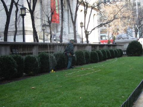
10 RESEARCH METHODS: 1) Architectural field survey of the New York Public Library. 2) Behavior mapping using counting and observation of activity.

11 ARCHITECTURAL FIELD SURVEY A SPATIAL THEORY OF PUBLIC SPACE

12 BEHAVIORAL MAPPING - AGGREGATE OF 6 20-MINUTE OBSERVATION PERIODS A SPATIAL THEORY OF PUBLIC SPACE
13 THEORY DEVELOPMENT: By combining architectural analysis with behavior mapping, it is possible to define the layers of space around the library as well as the boundaries and thresholds regulating the space.

14 NYPL AS VIEWED FROM 40TH STREET AND FIFTH AVENUE A SPATIAL THEORY OF PUBLIC SPACE
15 ISOMETRIC VIEW OF NEW YORK PUBLIC LIBRARY A SPATIAL THEORY OF PUBLIC SPACE

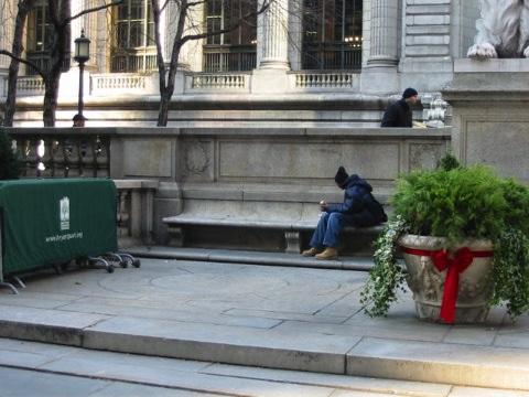
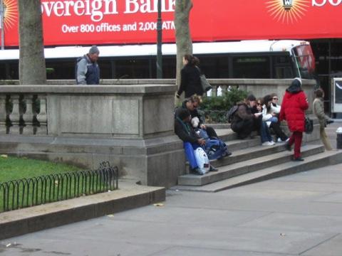
16 LAYER 0: PUBLIC SIDEWALK A SPATIAL THEORY OF PUBLIC SPACE

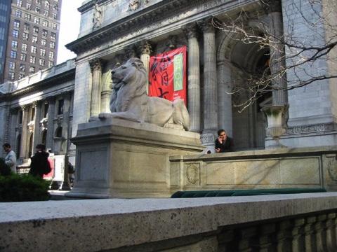
17 LAYER 1: ENTERING THE LIBRARY PRECINCT A SPATIAL THEORY OF PUBLIC SPACE

18 LAYER 2: THE LIBRARY TERRACE A SPATIAL THEORY OF PUBLIC SPACE

19 LAYER 3: THE ENTRY STAIRS A SPATIAL THEORY OF PUBLIC SPACE

20 RELATIONSHIP BETWEEN LAYERS OF PUBLIC SPACE A SPATIAL THEORY OF PUBLIC SPACE
21 THRESHOLDS BETWEEN LAYERS OF PUBLIC SPACE A SPATIAL THEORY OF PUBLIC SPACE
22 The design of the New York Public Library by John Carrere and Thomas Hastings was guided by the idea that the architectural progression of the spaces should follow a logical, hierarchical sequence from the most easily accessible and public spaces, to the most removed, scholarly retreats Today most visitors begin a tour of the Library by proceeding through a series of ever more enclosed spaces: from the exterior steps, past the lions, through the sheltering portico, and into the gracious space of Astor Hall. NYPL: A Beaux-Arts Landmark (2003)
23
 Use thresholds to create smooth transitions between layers of space.")
24 SOME DESIGN SUGGESTIONS FROM THIS RESEARCH: 1) Create spatial boundaries to differentiate areas of use. 2) Use thresholds to create smooth transitions between layers of space. 3) Provide architectural features that allow opportunities to rest, change pace, or take a seat in spaces designed for public use.
Lecture 19: Common property resources
 Lecture 19: Common property resources Economics 336 Economics 336 (Toronto) Lecture 19: Common property resources 1 / 19 Introduction Common property resource: A resource for which no agent has full property
Between Art and Nature
 Between Art and Nature NEXT HELSINKI Next Helsinki invites a review of the proposed Guggenheim Museum and its South Harbour site in the context of enhancing the orientation for tourists in the city within
All images are artist conceptual renderings for illustrative purposes only.
 A M P L I F Y M I D T O W N S F I F T H I N F O C U S 2 A N E W P E R S P E C T I V E T H E M A G N I F Y I N G C O R N E R 3 All images are artist conceptual renderings for illustrative purposes only.
North Carolina Essential Standards Kindergarten Social Studies
 North Carolina s Kindergarten Social Studies Kindergarten through second grade students are introduced to an integrative approach of Social Studies by exploring aspects of self, others, families and communities
Many Ways to Name a Place
 Your web browser (Safari 7) is out of date. For more security, comfort and Activityapply the best experience on this site: Update your browser Ignore Many Ways to Name a Place What are the names for the
KETCHUM ARTS COMMISSION INTERACTIVE ART CALL FOR ARTISTS Request for Qualifications
 KETCHUM ARTS COMMISSION INTERACTIVE ART CALL FOR ARTISTS Request for Qualifications I N T R O D U C T I O N The City of Ketchum, Idaho, invites professional artists, architects or designers to apply for
Urban semi-enclosed spaces as climate moderators
 September 2004 Page 1 of 5 Urban semi-enclosed spaces as climate moderators ia Sinou 1 and Koen Steemers 2 The tin Centre for Architectural and Urban Studies, University of Cambridge, 6 Chaucer Road, CB2
Grade 5 Lesson 3. Lesson Plan Page 2. Page 6. Student Activity Handout 1 Map Practice. Student Activity Handout 2 Marlins Park Maps.
 Grade 5 Lesson 3 Item Page Lesson Plan Page 2 Student Activity Handout 1 Map Practice Page 6 Student Activity Handout 2 Marlins Park Maps Page 10 DETERMINING METHODS VISION-SETTING Marlins Think Tank:
ELEMENTS OF GROUP THEORY FOR PHYSICISTS BY A. W JOSHI DOWNLOAD EBOOK : ELEMENTS OF GROUP THEORY FOR PHYSICISTS BY A. W JOSHI PDF
 Read Online and Download Ebook ELEMENTS OF GROUP THEORY FOR PHYSICISTS BY A. W JOSHI DOWNLOAD EBOOK : ELEMENTS OF GROUP THEORY FOR PHYSICISTS BY A. W Click link bellow and free register to download ebook:
Problems In Large Cities
 Chapter 11 Problems In Large Cities Create a list of at least 10 problems that exist in large cities. Consider problems that you have read about in this and other chapters and/or experienced yourself.
About places and/or important events Landmarks Maps How the land is, hills or flat or mountain range Connected to maps World Different countries
 What do you think you know about geography? About places and/or important events Landmarks Maps How the land is, hills or flat or mountain range Connected to maps World Different countries What do you
the mis a ligned Yan Xin Huang Faculty Advisors: Andrew Atwood, Renee Chow Master of Architecture Thesis University of California, Berkeley
 the mis a ligned Yan Xin Huang Master of Architecture Thesis 2015-2016 University of California, Berkeley Faculty Advisors: Andrew Atwood, Renee Chow This thesis explores misalignment as a design strategy
A Map Through Time Virtual Historic Cities
 A Map Through Time Virtual Historic Cities NEW WAYS OF EXPLORING DIGITAL COLLECTIONS FLORIDA INTERNATIONAL UNIVERSITY JAMIE ROGERS Coral Gables Virtual Historic City & Unearthing St. Augustine s Colonial
POLYTECHNIC OF TORINO FACULTY OF ARCHITECTURE Degree in Architecture Honors theses
 POLYTECHNIC OF TORINO FACULTY OF ARCHITECTURE Degree in Architecture Honors theses Cartographie and project by Alfonso Carino e Fabrizio Gianotti Tutor: Giancarlo Motta Co-tutor: Antonia Pizzigoni e Riccardo
A STRUCTURAL ANALYSIS OF THE STREETS NETWORK TO URBAN FABRIC CHARACTERIZATION
 CO-165 A STRUCTURAL ANALYSIS OF THE STREETS NETWORK TO URBAN FABRIC CHARACTERIZATION HAMAINA R., LEDUC T., MOREAU G. Centre d'études et recherches méthodologiques d'architecture, NANTES, FRANCE ABSTRACT
What on Earth is Geography? Using the Five Themes of Geography to Study the Continent of Asia.
 What on Earth is Geography? Using the Five Themes of Geography to Study the Continent of Asia. Name Date Essential questions: 1. How can we study the geography of our Earth? a. What are the five themes
Chapter 1 Introduction
 1 Chapter 1 Introduction Figure 1.1: Westlake Plaza A warm sunny day on a downtown street and plaza, pedestrians pass on the sidewalks, people sit on benches and steps, enjoying a cup of coffee, shoppers
Intimate Infrastructures
 Intimate Infrastructures A social and spatial strategy for high-density design at a human scale By Natasha Reid Intimate Infrastructures Intimate Infrastructures A social and spatial strategy for high-density
MID OCEAN DRIVE. 1.4 acre oceanfront property in Bridgehampton, capable of yielding a 10,000SF+/- home, oceaanside pool, and tennis.
 MID OCEAN DRIVE BRIDGEHAMPTON N E W Y O R K 1.4 acre oceanfront property in Bridgehampton, capable of yielding a 10,000SF+/- home, oceaanside pool, and tennis. R E A L E S T A T E MID OCEAN DRIVE, BRIDGEHAMPTON,
where vibrancy and value INTERSECT
 W O R K A T T H E C E N T E R O F I T A L L C H A R L O T T E, N C where vibrancy and value INTERSECT BB&T is at the very heart of Uptown Charlotte, NC, part of a vibrant cityscape that abounds with business
CORRIDORS OF FREEDOM Access Management (Ability) Herman Pienaar: Director City Transformation and Spatial Planning
 Herman Pienaar: Director City Transformation and Spatial Planning") CORRIDORS OF FREEDOM Access Management (Ability) 2016 Herman Pienaar: Director City Transformation and Spatial Planning PLANNING DEVELOPMENT PROCESS RATHER THAN A PLAN CAPITAL INVESTMENT DEVELOPMENT FACILITATION
CORRIDORS OF FREEDOM Access Management (Ability) 2016 Herman Pienaar: Director City Transformation and Spatial Planning PLANNING DEVELOPMENT PROCESS RATHER THAN A PLAN CAPITAL INVESTMENT DEVELOPMENT FACILITATION
UNIT 14 REGIONAL LEVEL PLANNING
 UNIT 14 REGIONAL LEVEL PLANNING Structure 14.0 Objectives 14.1 Introduction 14.2 Tourism Regions and Planning 14.3 Establishment of Tourism Regions 14.4 Regional Organisational and Planning Structure 14.5
REPUBLIC OF ZAMBIA STATEMENT THE HONOURABLE LUCKY MULUSA, M.P., MINISTER OF NATIONAL DEVELOPMENT PLANNING,
 REPUBLIC OF ZAMBIA Permanent Mi$sion of Zambia to the United Nations, 237 East 52nd Street, New York, NY 10022 Tex: (212) 888-5770 Fax: (212) 888-5213 E-mail: zambia@un.int Please check against delivery
Cultural Routes of the Council of Europe - Glossary
 Cultural Routes of the Council of Europe - Glossary Below is a collection of terms linked to Cultural Routes of the Council of Europe. The glossary is taken from the book Cultural Routes management: from
YouGov Survey Results
 YouGov Survey Results Sample Size: 2090 GB Adults Fieldwork: 10th - 11th October 2010 Voting intention Gender Age Social grade Region The following questions are about horoscopes and star signs... Which
50 Varsity NOV 2012 ISSUE 125 CEMETERY STORIES
 50 Varsity NOV 2012 ISSUE 125 CEMETERY STORIES Photo Feature by Stephanie Cheng & Viola Yeh NOV 2012 ISSUE 125 Varsity 51 52 Varsity NOV 2012 ISSUE 125 I think the value of graves is the fact that so much
Western Treatment Plant (WTP)
") Western Treatment Plant (WTP) Venue and Safety Information Please complete the following important actions in preparation for your tour: Read and pass on the below information to all WTP tour participants.
Western Treatment Plant (WTP) Venue and Safety Information Please complete the following important actions in preparation for your tour: Read and pass on the below information to all WTP tour participants.
Grade 6 Social Studies
 Unit Title: Africa : Movement Location Place Human Region : Subject/Course: 6 th Grade Social Studies Essential Questions: peoples, cultures and ideas of the world? How is a location identified using map
SOCIAL SCIENCES. WORLD GEOGRAPHY LH Grade(s): 9 Pre-Req: N/A
: 9 Pre-Req: N/A") SOCIAL SCIENCES WORLD GEOGRAPHY 21033000 Grade(s): 9 The World Cultural Geography course consists of the following content area strands: American History, World History, Geography, Humanities, Civics and
SOCIAL SCIENCES WORLD GEOGRAPHY 21033000 Grade(s): 9 The World Cultural Geography course consists of the following content area strands: American History, World History, Geography, Humanities, Civics and
SITE REPORT #4 COVER IMAGE: The Picture below is a Black & White map of Farragut Houses and its neighbors found during our NYPL visit.
 Learning Places Spring 2017 SITE REPORT #4 COVER IMAGE: The Picture below is a Black & White map of Farragut Houses and its neighbors found during our NYPL visit. Thein Moe 03.30.2017 INTRODUCTION Our
CONSTRUCTION OF DIGITAL CITY IN PHYSICAL CITY
 CONSTRUCTION OF DIGITAL CITY IN PHYSICAL CITY Cyberspatial Cognition Approach to the project of HsinChu digital city in Taiwan YU-LI CHANG, YUAN-ZONE LEE AND YU-TUNG LIU Graduate Institute of Architecture,
Joanne N. Halls, PhD Dept. of Geography & Geology David Kirk Information Technology Services
 Joanne N. Halls, PhD Dept. of Geography & Geology David Kirk Information Technology Services Geographic Information Systems manage and analyze data to solve spatial problems. Real World Abstraction Analysis
Current Functions (Enter categories from instructions) Materials (Enter categories from instructions)
 Materials (Enter categories from instructions)") Site Inventory Form State Inventory No. 92-00490 New Supplemental State Historical Society of Iowa Part of a district with known boundaries (enter inventory no.) 92-00349 (November 2005) Relationship:
Site Inventory Form State Inventory No. 92-00490 New Supplemental State Historical Society of Iowa Part of a district with known boundaries (enter inventory no.) 92-00349 (November 2005) Relationship:
Social Studies Grade 2 - Building a Society
 Social Studies Grade 2 - Building a Society Description The second grade curriculum provides students with a broad view of the political units around them, specifically their town, state, and country.
Urban Geography. Unit 7 - Settlement and Urbanization
 Urban Geography Unit 7 - Settlement and Urbanization Unit 7 is a logical extension of the population theme. In their analysis of the distribution of people on the earth s surface, students became aware
Dublin City Schools Social Studies Graded Course of Study Grade 5 K-12 Social Studies Vision
 K-12 Social Studies Vision The Dublin City Schools K-12 Social Studies Education will provide many learning opportunities that will help students to: develop thinking as educated citizens who seek to understand
Integrated Postsecondary Education Data System
 University of Nebraska Omaha DigitalCommons@UNO IPEDS Completions Integrated Postsecondary Education Data System 203 Completions 203-4 UNO Office of Institutional Effectiveness University of Nebraska at
Graduation Reflection Charging walls: The weaving city. Quan Phitakraxanti
 Graduation Reflection Charging walls: The weaving city Quan Phitakraxanti 4301412 Msc4 Analysis and Intervention in the Afropolis Chair of Methods and analysis Tutors: Prof. Dr. Tom Avermaete, Ir. Jorge
Assessment Design. AGTA Conference Rotorua NZ January 2015
 Assessment Design AGTA Conference Rotorua NZ January 2015 The StAR team Standards, Assessment and Reporting How do we know? Assessment Urban settlement 1. List 3 advantages of living in your local town
D e s i g n. Design is the conscious and intuitive effort to impose meaningful order. - Victor Papanek
 D e s i g n [d ZIN] 1 To conceive, invent, contrive 2 To form a plan for 3 To draw a sketch 4 To have as a goal or purpose, to intend 5 A visual composition, pattern 6 A reasoned purpose, intention Design
Arizona Recreation Map By Benchmark Maps READ ONLINE
 Arizona Recreation Map By Benchmark Maps READ ONLINE Families can come and see what the Sierra Montana Recreation Center has to offer. The center has a game room with Xbox 360s on high definition TV's,
Developing urban ecosystem accounts for Great Britain. Emily Connors Head of Natural Capital Accounting Office for National Statistics (UK)
") Developing urban ecosystem accounts for Great Britain Emily Connors Head of Natural Capital Accounting Office for National Statistics (UK) UN 2014 UN 2014 ONS 2017 UK motivation 54% 82% 5,900 Of the world
Developing urban ecosystem accounts for Great Britain Emily Connors Head of Natural Capital Accounting Office for National Statistics (UK) UN 2014 UN 2014 ONS 2017 UK motivation 54% 82% 5,900 Of the world
Harvey Dunn Weather on the Plains. Provided by the South Dakota Art Museum Brookings, South Dakota
 Harvey Dunn Weather on the Plains Provided by the South Dakota Art Museum Brookings, South Dakota South Dakota Artists Curriculum Unit Unit of Study: Harvey Dunn, painter Title of Lesson Plan: Weather
Urban Foundations. Early American Cities. Early American Cities. Early American Cities. Cities in America to 1945
 Urban Foundations Cities in America to 1945 Early American Cities The design of early American cities was highly influenced by European traditions The roots of many of these traditions can in turn be traced
T H E R E Q U I R E M E N T S F O R T H E D E G R E E O F M A S T E R O F A R T S
 R E L A T I O N S H I P B E T W E E N M A T H E M A T I C S A N X I E T Y A N D A C H I E V E M E N T I N M A T H E M A T I C S : A M E T A - A N A L Y S I S by G A B R I E L E. T A Y L O R B. E d., U
The Community Maps Project Craig Roland! The University of Florida! January 2002!
 Preliminary map by a 4th grader Community Map by Four Art Buddies The Community Maps Project Craig Roland! The University of Florida! January 2002! The Community Maps Project represents a collaborative
TRAITS to put you on the map
 TRAITS to put you on the map Know what s where See the big picture Connect the dots Get it right Use where to say WOW Look around Spread the word Make it yours Finding your way Location is associated with
HW: Scatter Plots. 1. The scatter plot below shows the average traffic volume and average vehicle speed on a certain freeway for 50 days in 1999.
 Name: Date: 1. The scatter plot below shows the average traffic volume and average vehicle speed on a certain freeway for 50 days in 1999. 2. Ms. Ochoa recorded the age and shoe size of each student in
GOVERNMENT GIS BUILDING BASED ON THE THEORY OF INFORMATION ARCHITECTURE
 GOVERNMENT GIS BUILDING BASED ON THE THEORY OF INFORMATION ARCHITECTURE Abstract SHI Lihong 1 LI Haiyong 1,2 LIU Jiping 1 LI Bin 1 1 Chinese Academy Surveying and Mapping, Beijing, China, 100039 2 Liaoning
Declaration Population and culture
 Declaration Population and culture The ministers of the parties to the Alpine Convention regard the socio-economic and socio-cultural aspects mentioned in Article 2, Paragraph 2, Item a., as being central
APPENDIX D QUESTIONS/ACTIVITIES FOR TEACHERS AND STUDENTS
 APPENDIX D QUESTIONS/ACTIVITIES FOR TEACHERS AND STUDENTS The questions below are intended for teachers as they educate K-12 Geography students using the Japanese American relocation centers as their focal
Specified Issue. Pic3. Spring 2015
 Pic3 12 Pic1 11 Pic6 Pic2 10 Pic5 performance since structured streets and important buildings surround it. According to the distance index, the tissue is not too dense, while high-rise buildings are observed.
ARGUS.net IS THREE SOLUTIONS IN ONE
 OVERVIEW H i g h l y c o n f i g u r a b l e s o f t w a r e a c c o m m o d a t e s a w i d e r a n g e o f c o l l e c t i o n s T h r e e s o l u t i o n s c o v e r P o r t a l s, C o l l e c t i o
Mining Group Gold By Thomas A. Kayser
 Mining Group Gold By Thomas A. Kayser If you are searching for a ebook Mining Group Gold by Thomas A. Kayser in pdf form, then you've come to the correct website. We present the full variant of this ebook
CITY OF PASADENA CIVIC CENTER + PLAYHOUSE DISTRICT PARKING STRUCTURE FEASIBILITY STUDY
 + PLAYHOUSE DISTRICT PARKING STRUCTURE FEASIBILITY STUDY 4 S E P T E M B E R 2 2 C:\Documents and Settings\dsanchez.PASADENA\My Documents\P7.pasgar_CENTRAL_dsanchez.rvt Telephone (T) 87.49 3' - " Electrical
NATHAN HALE HIGH SCHOOL PARKING AND TRAFFIC ANALYSIS. Table of Contents
 Parking and Traffic Analysis Seattle, WA Prepared for: URS Corporation 1501 4th Avenue, Suite 1400 Seattle, WA 98101-1616 Prepared by: Mirai Transportation Planning & Engineering 11410 NE 122nd Way, Suite
Geography: Place & Liveability
 Geography: Place & Liveability Learning Area(s) Geography Year(s) 6, 7 Description AC Geography : Year 6 A diverse and connected world takes a global view of geography and focuses particularly on the concepts
SNOW AND ICE REMOVAL PROCEDURES
 SNOW AND ICE REMOVAL PROCEDURES Policy: Expeditious removal of ice and snow from vehicle and pedestrian access ways is essential for the safe operation of the University as referenced in the University
Auckland Transport. Auckland Council. Statement of Evidence of Simon John Ferneyhough
 Under the Resource Management Act 1991 In the matter of Notices of Requirement to enable the construction, operation and maintenance of the City Rail Link Between Auckland Transport Requiring Authority
AP Human Geography Syllabus
 AP Human Geography Syllabus Textbook The Cultural Landscape: An Introduction to Human Geography. Rubenstein, James M. 10 th Edition. Upper Saddle River, N.J.: Prentice Hall 2010 Course Objectives This
Early College High School PreAP World Geography Summer Reading Assignment
 Early College High School PreAP World Geography Summer Reading Assignment In preparation for your studies in World Geography you will be familiarizing yourself with the 5 Themes of Geography. This assignment
Architectural Thesis. Designs. Texts J' H B. S. * 9 . «.->.-*., x * UKJVERSITY OF ILL. iir.kjlhv
 Architectural Thesis Designs Texts J H B. S. 1901 9 4. «.->.-., UKJVERSITY OF ILL. iir.kjlhv x 4 4-4" :#: 4 f # +. ft f f ^ # # # 4 CLASS. \ RT2_ Accession No Of 4 (taming an!) abor. W + LIBRARY Of THE
Teacher Activity Packet: Observation Guide
 Teacher Activity Packet: Observation Guide Encourage your students to participate in a world-wide citizen science campaign to observe and record the magnitude of visible stars as a means of measuring light
Making space for a more foundational construction sector in Brussels
 Making space for a more foundational construction sector in Brussels Sarah De Boeck, David Bassens & Michael Ryckewaert Social innovation in the Foundational Economy Cardiff, 5 th of September 2018 1.
Grade. Why are maps useful? What do maps tell us?
 ACTIVITY 2.1 Follow That DART Bus! DETAILS TYPE Whole-group TIME 20 minutes plus 20 minutes homework (40 minutes total) PRINTED MATERIALS Handouts (Reading A Map, Follow that DART Bus! map and Follow that
Bev Knight
 S O U T H O C E A N B O U L E V A R D Artist s Conception Perched high atop private dunes, this grande Beach House Extraordinaire exudes casual elegance in every detail with captivating ocean views! 4205
MID OCEAN DRIVE. 1.4 acre oceanfront property in Bridgehampton BRIDGEHAMPTON MID OCEAN DRIVE, BRIDGEHAMPTON, NY 1
 MID OCEAN DRIVE BRIDGEHAMPTON N E W Y O R K 1.4 acre oceanfront property in Bridgehampton R E A L E S T A T E MID OCEAN DRIVE, BRIDGEHAMPTON, NY 1 MID OCEAN DRIVE PRESENTS A RARE OPPORTUNITY TO LIVE IN
GIS Data, Technology, and Models. to Integrate Information and Improve Transportation Decision-Making. within the Eco-Logical* Framework for Oregon
 GIS Data, Technology, and Models to Integrate Information and Improve Transportation Decision-Making within the Eco-Logical* Framework for Oregon GIS-T 2009, Oklahoma City, OK April 8, 2009, Session 5..2.2
The spatial network Streets and public spaces are the where people move, interact and transact
 The spatial network Streets and public spaces are the where people move, interact and transact The spatial network Cities are big spatial networks that create more of these opportunities Five key discoveries
Line of symmetry Total area enclosed is 1
 The Normal distribution The Normal distribution is a continuous theoretical probability distribution and, probably, the most important distribution in Statistics. Its name is justified by the fact that
255 UNION BLVD. ST. LOUIS, MO FULLY BUILT OUT RESTAURANT AND PUB SPACE FOR LEASE IN THE HIGHLY SOUGHT AFTER CENTRAL WEST END TRADE AREA OF ST. LOUIS.
 255 UNION BLVD. ST. LOUIS, MO FULLY BUILT OUT RESTAURANT AND PUB SPACE FOR LEASE IN THE HIGHLY SOUGHT AFTER CENTRAL WEST END TRADE AREA OF ST. LOUIS. MARKET OVERVIEW POPULATION 1 MI 3 MI 5 MI 16,135 157,095
National Register of Historic Places Registration Form
 United States Department of the Interior National Park Service National Register of Historic Places Registration Form This form is for use in nominating or requesting determinations for individual properties
DBSA Knowledge Week Yusuf Patel South African Planning Institute
 Sustainable Human Settlements - Institutional Issues DBSA Knowledge Week Yusuf Patel South African Planning Institute 20 October 2010 Spatial Planning for Long Term Apartheid engineered spatial economy
USER PARTICIPATION IN HOUSING REGENERATION PROJECTS
 USER PARTICIPATION IN HOUSING REGENERATION PROJECTS Dr. Hatice Sadıkoğlu Bahçeşehir University, Faculty of Architecture and Design Prof. Dr. Ahsen Özsoy Istanbul Technical University, Faculty of Architecture
UN-GGIM: Strengthening Geospatial Capability
 Fifth Plenary Meeting of UN-GGIM: Europe Brussels, 6-7 June 2018 UN-GGIM: Strengthening Geospatial Capability Walking the talk to leave no one behind Greg Scott, UN-GGIM Secretariat Environmental Statistics
You can't get there from here: Mapping access to Canada's teacher education programs
 You can't get there from here: Mapping access to Canada's teacher education programs Cameron William Smith, Peter Peller Werklund School of Education, University of Calgary Context/Process Initial, exploratory
SAFETY SURFACES & RUBBER MOLDED PRODUCTS
 RUBBER MOLDED PRODUCTS SAFETY SURFACES & RUBBER MOLDED PRODUCTS OVERVIEW V i s t a L i n e y o u r u r b a n s c e n e r e i m a g i n e d, r e n e w e d, a n d n a t u r a l i z e d! S o f t l i n e S
Grade 7 Social Studies
 Standard 1: History Students will examine the major movements, events, and figures that contributed to the development of nations in modern Africa, Asia, and the Southwest Pacific from acient civilizations
National Geographic Map - Switzerland, Austria And Northern Italy By National Geographic Society
 National Geographic Map - Switzerland, Austria And Northern Italy By National Geographic Society If looking for a book National Geographic Map - Switzerland, Austria and Northern Italy by National Geographic
The maps in this resource can be freely modified and reproduced in the classroom only.
 Teacher's Notes In this activity, students work collaboratively to explore sections of old and new maps. By closely examining these documents, students learn to see maps as more than just tools for locating
Haveouts Guided Notes Pen/pencil CAV Card DFAD
 Haveouts Guided Notes Pen/pencil CAV Card DFAD Do First: Answer in your DFAD Answer the questions are in your Guided Notes, be sure to record your answers in your DFAD. You have 5 mins. Haveouts Guided
Lecture 9: Geocoding & Network Analysis
 Massachusetts Institute of Technology - Department of Urban Studies and Planning 11.520: A Workshop on Geographic Information Systems 11.188: Urban Planning and Social Science Laboratory Lecture 9: Geocoding
Nature s Art Village
 Nature s Art Village Educational Field Trip Programs Guide To: College, Career & Civic Life C3 Framework For Social Studies State Standards Grades 3 through 5 All That Glitters Children journey back in
Professor Christoph B. Graber, PhD Spring Semester Master s Module Exam Legal Sociology , Uhr
 Professor Christoph B. Graber, PhD Spring Semester 2015 Duration: 120 minutes Master s Module Exam Legal Sociology 25.06.2015, 13.00 15.00 Uhr Notes on the multiple choice questions We strongly recommend
Course Outcome Summary
 Course Information: Description: Instruction Level: Total Credits: Prerequisites: Textbooks: Human Geography The starting point of this class will include basic building block skills, such as how to read
An integrated luxury hub spread over 9 acres (approximately 3.2 million sq.ft), MMR 52nd Avenue is located in the heart of Central Noida just two
, MMR 52nd Avenue is located in the heart of Central Noida just two") An integrated luxury hub spread over acres (approximately. million sq.ft), MMR nd Avenue is located in the heart of Central Noida just two minutes away from the City Centre. It has always been known as
An integrated luxury hub spread over acres (approximately. million sq.ft), MMR nd Avenue is located in the heart of Central Noida just two minutes away from the City Centre. It has always been known as
THE DOCTRINES AND DISCIPLINE OF THE AZUSA STREET APOSTOLIC FAITH MISSION OF LOS ANGELES (THE COMPLETE AZUSA STREET LIBRARY) BY WILLIAM JO
 BY WILLIAM JO") Read Online and Download Ebook THE DOCTRINES AND DISCIPLINE OF THE AZUSA STREET APOSTOLIC FAITH MISSION OF LOS ANGELES (THE COMPLETE AZUSA STREET LIBRARY) BY WILLIAM JO DOWNLOAD EBOOK : THE DOCTRINES AND
Read Online and Download Ebook THE DOCTRINES AND DISCIPLINE OF THE AZUSA STREET APOSTOLIC FAITH MISSION OF LOS ANGELES (THE COMPLETE AZUSA STREET LIBRARY) BY WILLIAM JO DOWNLOAD EBOOK : THE DOCTRINES AND
Community Involvement in Research Monitoring Pollinator Populations using Public Participation in Scientific Research
 Overview Community Involvement in Research Monitoring Pollinator Populations using Public Participation in Scientific Research Public Participation in Scientific Research (PPSR) is a concept adopted by
Bogota, Colombia November 22-30, 2015 Cristo Rey Jesuit High School
 Bogota, Colombia November 22-30, 2015 Cristo Rey Jesuit High School Pathways to Children created for Cristo Rey students LIFE-CHANGING TRAVEL AND VOLUNTEER OPPORTUNITIES While they were in Bogota, Colombia
Place Syntax Tool (PST)
") Place Syntax Tool (PST) Alexander Ståhle To cite this report: Alexander Ståhle (2012) Place Syntax Tool (PST), in Angela Hull, Cecília Silva and Luca Bertolini (Eds.) Accessibility Instruments for Planning
Place Syntax Tool (PST) Alexander Ståhle To cite this report: Alexander Ståhle (2012) Place Syntax Tool (PST), in Angela Hull, Cecília Silva and Luca Bertolini (Eds.) Accessibility Instruments for Planning
A S P A C E F O R Y E S T E R D A Y, T O D A Y & T O M O R R O W
 A S P A C E F O R Y E S T E R D A Y, T O D A Y & T O M O R R O W L E T ' S B U I L D H I S T O R Y T H E C E N T R E L E T ' S B U I L D T H E ( N E W ) C E N T R E F O R G E N D E R & S E X U A L D I
NEW YORK DEPARTMENT OF SANITATION. Spatial Analysis of Complaints
 NEW YORK DEPARTMENT OF SANITATION Spatial Analysis of Complaints Spatial Information Design Lab Columbia University Graduate School of Architecture, Planning and Preservation November 2007 Title New York
Lesson Plan by: Stephanie Miller
 Lesson: Pythagorean Theorem and Distance Formula Length: 45 minutes Grade: Geometry Academic Standards: MA.G.1.1 2000 Find the lengths and midpoints of line segments in one- or two-dimensional coordinate
WS/FCS Unit Planning Organizer
 WS/FCS Unit Planning Organizer Subject(s) Social Studies Conceptual Lenses Grade/Course 3rd Place Unit of Study Five Themes of Geography Location Unit Title Pacing Geo Explorers 20-22 days Human environment
Strategic Framework Executive Summary JANUARY 2018
 Strategic Framework Executive Summary JANUARY 2018 LETTER FROM OUR BOARD For the people of Los Angeles and the world beyond, the Natural History Family of Museums explores connections between nature, culture,
Lesson 2 DRAWING A SIMPLE MAP WALT: Draw a simple map. Lesson 3 DRAWING A MAP TO SCALE. scale map.
 Year 3 GEOGRAPHY Mapping Lesson 1 WHAT MAPS SHOW US WALT: Describe the purpose of a map. Lesson 2 DRAWING A SIMPLE MAP WALT: Draw a simple map. Lesson 3 DRAWING A MAP TO SCALE WALT: Draw a simple scale
SENIOR HOUSING REDEVELOPMENT PROJECT
 THE HISTORIC WILEY H. BATES HIGH SCHOOL Project Team: SENIOR HOUSING REDEVELOPMENT PROJECT Community Preservation and Development Corporation Northern Real Estate, L.L.C. Wiencek + Associates Architects
Haslemere Design Statement
 For Beacon Hill, Critchmere, Grayswood, Haslemere, Hindhead and Shottermill Ensuring new development takes account of local character Contents Overview 3 1. Introduction 4 2. What makes Haslemere Special
The city as a system
 AP SYSTEMS PLANNER 16 (2013) Anastássios Perdicoúlis Assistant Professor, ECT, UTAD (http://www.tasso.utad.pt) Affiliate Researcher, CITTA, FEUP (http://www.fe.up.pt/~tasso) Abstract Contrary to popular
TERCET: A European regulation on statistical units and territorial typologies
 TERCET: A European regulation on statistical units and territorial typologies NUAC Meeting 10 May 2016 Eurostat Unit E4 Regulation (EC) No 1059/2003: - Establishes a classification of territorial units