Decoupling living standards and resources. Ella Susanne Lawton MSc LLB Centre for Sustainable Practice
|
|
|
- Evelyn Booker
- 5 years ago
- Views:
Transcription


1 Decoupling living standards and resources Ella Susanne Lawton MSc LLB Centre for Sustainable Practice

2 The New Zealand Footprint Project 3 years, FRST Victoria University of Wellington Auckland Council Otago Polytechnic Provide knowledge on how to improve the efficiency of resource use in order to guide policies and practices for robust future settlement development. Ecological Footprint, Urban Form, Lifestyles - time, money, values

3 Total and average NZ 2007 footprint by category
4 New Zealand fair earth share 1.21 New Zealand hectares On average a New Zealander requires 2.1 planets to support their way of life This is an underestimate! More than one planet would be required just for food


5 One Hectare The grass in the centre of a standard athletic track is a little over one hectare in extent The maximum playing area of an international-sized rugby union field is about one hectare Kiwi quarter acre section = x10

6 New Zealand Average Ecological Footprint 2007

7 New Zealand Average Ecological Footprint 2007
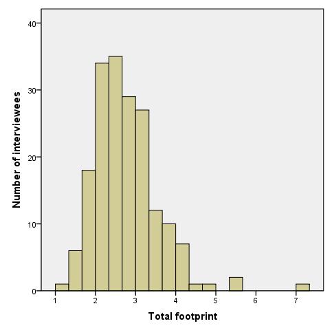

8 Distribution of Footprint interviews
9 Wellbeing Satisfaction with life increased with household income level. However, the largest increase in life satisfaction occurred between the two lowest household income groups ( $30,000 or less and $30,001 $70,000 ), with progressively smaller increases in life satisfaction at higher income groups. In addition to lower life satisfaction, people in lower income households were more likely to report feeling unsafe walking alone in their neighbourhood at night and to say they had fair or poor health than people in higher income households. - New Zealand General Social Survey: 2010

10 8 Tribes Analysis

11 Footprint and Income
12 Footprint and income Total footprint weak correlation Including pets Holiday footprint strong correlation Flying
.")
13 Time Lawton, E. (in press). Footprint and Income. Living within a fair share footprint. R. Vale and B. Vale. London, Thames and Hudson. Statistics New Zealand. (2011). Time Use Survey: 2009/10.

14 1. Statistics New Zealand. (2007). Household Economic Survey: Year ended 30 June Statistics New Zealand. (2011). Time Use Survey: 2009/10.

15 Kapiti Coast Greenest Streets Competition The community depends on the natural environment for its wellbeing, so an increasingly degraded environment threatens the very foundations of wellbeing. These natural limits to community wellbeing can, at least partly, be forestalled if the community adopts more environmentally sustainable practices that place less burden on the natural environment. (LTP , p.157)
16 Te Roto Road, Otaki, 2010/11 Carless Days Each resident committed to one carless day a week Saved 13,022kg or 13 metric tonnes of carbon over the course of the competition At an average fuel price of $2/L, this equated to a combined saving of $11,333 Saved a footprint of 1.25 hectares $9,000 per hectare
17 Increasing wellbeing whilst reducing footprint Closer together is about enriching our lives and doing better by the environment at the same time. We share more, talk more, grow more and as a consequence have to travel and spend less. This leads to a diminishing carbon footprint. So we treasure the stronger friendships we have, the food we grow and share and that we receive in return. Kakariki Street, 2010/11
18 2010/2011 Footprint in Earths Street October 2010 June 2011 % improvement Avion Terrace % Rainbow Court % Te Roto Road % Kakariki Street % 2011/2012 Footprint in Earths Street October 2011 June 2012 % improvement Alexander Rd % Wellington Rd % Grange Park Ave % The New Zealand average footprint was 3.7 Earths for 2010/11 & 2011/12

19 Most effective way to reduce your footprint
20 Summary Food is pivotal to the overall footprint so we need to put more emphasis here It is possible to offset household income with access to land and/or strong collective community However this takes reprioritising how people spend their time and money Income does not seem to be a good indicator of footprint so we need to dig deeper
Shaping Your Neighbourhood
 Shaping Your Neighbourhood Building a Core Sustainable Neighbourhood Action Plan Nov. 25 & 26, 2006 Welcome! Peter Russell Planner, Holland Barrs Planning Group Inc. Role in this project: Work with the
Long Term Plan What is planned for Murchison?
 Long Term Plan 2018-2028 What is planned for Murchison? 1.0 Introduction The following information provides an overview of significant projects Council has planned for the Murchison settlement in the Long
convenience truth 4 concepts and their SYNTHESIS a convenience truth 5.0
 5.0 Concept 1 Interconnected Places: Use the framework of our arterials to both connect and distinguish urban places Vancouver s existing urban structure, based on the original streetcar city pattern,
RURAL SETTLEMENT PATTERNS AND ACCESS TO DEVELOPMENT LAND: DEVELOPING THE EVIDENCE BASE
 School of Planning, Architecture and Civil Engineering RURAL SETTLEMENT PATTERNS AND ACCESS TO DEVELOPMENT LAND: DEVELOPING THE EVIDENCE BASE Prepared for Friends of the Earth Northern Ireland 18 th April
Intimate Infrastructures
 Intimate Infrastructures A social and spatial strategy for high-density design at a human scale By Natasha Reid Intimate Infrastructures Intimate Infrastructures A social and spatial strategy for high-density
Spatial Web Technology for Urban Green Society (A Case of Tsukuba City)
") The 5th Japan-Korea-China Joint Conference on Geography (Green Society in East Asia: A Geographical Contribution) Spatial Web Technology for Urban Green Society (A Case of Tsukuba City) Ko Ko Lwin and
The 5th Japan-Korea-China Joint Conference on Geography (Green Society in East Asia: A Geographical Contribution) Spatial Web Technology for Urban Green Society (A Case of Tsukuba City) Ko Ko Lwin and
Neighbourhood Planning in Haringey. Myddleton Road Strategic Group 7 th November 2013
 Neighbourhood Planning in Haringey Myddleton Road Strategic Group 7 th November 2013 What is Neighbourhood Planning? Neighbourhood Planning, introduced through the Localism Act 2011, offers an opportunity
Measuring Perceived Accessibility to Urban Green Space: An Integration of GIS and Participatory Map
 Measuring Perceived Accessibility to Urban Green Space: An Integration of GIS and Participatory Map Fariba Sotoudehnia, Lex Comber 1,2 Department of Geography, University of Leicester, UK ABSTRACT Urban
Coastal Hazard and Climate-Change Risk Exposure in New Zealand: Comparing Regions and Urban Areas
 Presented at the FIG Working Week 2016, May 2-6, 2016 in Christchurch, New Zealand Coastal Hazard and Climate-Change Risk Exposure in New Zealand: Comparing Regions and Urban Areas Rob Bell, Ryan Paulik
Understanding consumption in Melbourne s multicultural society
 Understanding consumption in Melbourne s multicultural society ECOCITY WORLD SUMMIT 12-14 JULY 2017 Dr. Christina YP Ting Prof. Peter Newton Asso. Prof. Wendy Stone Centre for Urban Transitions Swinburne
Challenges of Urbanisation & Globalisation
 Challenges of Urbanisation & Globalisation Prepared by: Khairul Hisyam Kamarudin, PhD Feb 2016 Based on original lecture note by: Wan Nurul Mardiah Wan Mohd Rani, PhD URBANIZATION What is Urbanization?
Healthy Cities. Lecture 4 Planning and Regeneration, Sustainable and Healthy. Opening Address
 Healthy Cities Lecture 4 Planning and Regeneration, Sustainable and Healthy Opening Address Suzanne Wylie Director of Health and Environmental Services, Belfast City Council Belfast The Past The Present
Energy Use in Homes. A series of reports on domestic energy use in England. Energy Efficiency
 Energy Use in Homes A series of reports on domestic energy use in England Energy Efficiency Energy Use in Homes A series of reports on domestic energy use in England This is one of a series of three reports
GOVERNMENT MAPPING WORKSHOP RECOVER Edmonton s Urban Wellness Plan Mapping Workshop December 4, 2017
 GOVERNMENT MAPPING WORKSHOP 12.4.17 RECOVER Edmonton s Urban Wellness Plan Mapping Workshop December 4, 2017 In July of 2017, City Council directed administration to develop RECOVER, Edmonton s Urban Wellness
Vincent Goodstadt. Head of European Affairs METREX European Network
 Vincent Goodstadt Head of European Affairs METREX European Network METREX (Network of 50 European Metropolitan Regions and Areas ) Exchanging Knowledge (e.g. Benchmarking) Climate Change CO2/80/50 Expertise
Most people used to live like this
 Urbanization Most people used to live like this Increasingly people live like this. For the first time in history, there are now more urban residents than rural residents. Land Cover & Land Use Land cover
Environmental Analysis, Chapter 4 Consequences, and Mitigation
 Environmental Analysis, Chapter 4 4.17 Environmental Justice This section summarizes the potential impacts described in Chapter 3, Transportation Impacts and Mitigation, and other sections of Chapter 4,
Transport Planning in Large Scale Housing Developments. David Knight
 Transport Planning in Large Scale Housing Developments David Knight Large Scale Housing Developments No longer creating great urban spaces in the UK (Hall 2014) Transport Planning Transport planning processes
Tackling urban sprawl: towards a compact model of cities? David Ludlow University of the West of England (UWE) 19 June 2014
 19 June 2014") Tackling urban sprawl: towards a compact model of cities? David Ludlow University of the West of England (UWE) 19 June 2014 Impacts on Natural & Protected Areas why sprawl matters? Sprawl creates environmental,
Tackling urban sprawl: towards a compact model of cities? David Ludlow University of the West of England (UWE) 19 June 2014 Impacts on Natural & Protected Areas why sprawl matters? Sprawl creates environmental,
ASIA GEOSPATIAL FORUM 2011 Eco-Friendly Walk Score Calculator Choosing a Place to Live with GIS
 ASIA GEOSPATIAL FORUM 2011 Eco-Friendly Walk Score Calculator Choosing a Place to Live with GIS Ko Ko Lwin and Yuji Murayama Division of Spatial Information Science Graduate School of Life and Environmental
Together towards a Sustainable Urban Agenda
 Together towards a Sustainable Urban Agenda The City We (Youth) Want Preliminary findings from youth consultations Areas Issue Papers Policy Units 1.Social Cohesion and Equity - Livable Cities 2.Urban
North Carolina Essential Standards Kindergarten Social Studies
 North Carolina s Kindergarten Social Studies Kindergarten through second grade students are introduced to an integrative approach of Social Studies by exploring aspects of self, others, families and communities
Marking Scheme Field Work. 6 International Geography Olympiad. Brisbane
 Marking Scheme Field Work th 6 International Geography Olympiad Brisbane June 2006 Question - Map - 7 Marks Mark out of 4 and divide by 2 at the end. (Sample map was provided to markers.) Shading according
September Creating liveable cities in Australia A scorecard and priority recommendations for Melbourne
 September 2018 Creating liveable cities in Australia A scorecard and priority recommendations for Melbourne What makes a liveable city? The term liveability is widely used in Australia and across the world,
Food Mapping for Community Food Activity. A Briefing Paper from the Scottish Community Diet Project Round Table Discussion.
 Food Mapping for Community Food Activity A Briefing Paper from the Scottish Community Diet Project Round Table Discussion 27 May 2004 Food mapping has been defined as the process of finding out where people
Leveraging Urban Mobility Strategies to Improve Accessibility and Productivity of Cities
 Leveraging Urban Mobility Strategies to Improve Accessibility and Productivity of Cities Aiga Stokenberga World Bank GPSC African Regional Workshop May 15, 2018 Roadmap 1. Africa s urbanization and its
Local Area Key Issues Paper No. 13: Southern Hinterland townships growth opportunities
 Draft Sunshine Coast Planning Scheme Review of Submissions Local Area Key Issues Paper No. 13: Southern Hinterland townships growth opportunities Key Issue: Growth opportunities for Southern Hinterland
Relationships between land use, socioeconomic factors, and travel patterns in Britain
 Environment and Planning B: Planning and Design 2001, volume 28, pages 499 ^ 528 DOI:10.1068/b2677 Relationships between land use, socioeconomic factors, and travel patterns in Britain Dominic Stead The
Typical information required from the data collection can be grouped into four categories, enumerated as below.
 Chapter 6 Data Collection 6.1 Overview The four-stage modeling, an important tool for forecasting future demand and performance of a transportation system, was developed for evaluating large-scale infrastructure
Climate Change Adaptation and New Migrants
 Climate Change Adaptation and New Migrants ACCARNSI CONFERENCE 2016, Early Career Researcher, 12 th National Forum and Workshop 26-28 September 2016 Christina YP Ting Swinburne University of Technology
Abstract. 1 Introduction
 Urban density and car and bus use in Edinburgh Paul Dandy Department of Civil & Transportation Engineering, Napier University, EH10 5DT, United Kingdom EMail: p.dandy@napier.ac.uk Abstract Laissez-faire
HSC Geography. Year 2013 Mark Pages 10 Published Jul 4, Urban Dynamics. By James (97.9 ATAR)
") HSC Geography Year 2013 Mark 92.00 Pages 10 Published Jul 4, 2017 Urban Dynamics By James (97.9 ATAR) Powered by TCPDF (www.tcpdf.org) Your notes author, James. James achieved an ATAR of 97.9 in 2013 while
HSC Geography Year 2013 Mark 92.00 Pages 10 Published Jul 4, 2017 Urban Dynamics By James (97.9 ATAR) Powered by TCPDF (www.tcpdf.org) Your notes author, James. James achieved an ATAR of 97.9 in 2013 while
Data Collection. Lecture Notes in Transportation Systems Engineering. Prof. Tom V. Mathew. 1 Overview 1
 Data Collection Lecture Notes in Transportation Systems Engineering Prof. Tom V. Mathew Contents 1 Overview 1 2 Survey design 2 2.1 Information needed................................. 2 2.2 Study area.....................................
MODULE 1 INTRODUCING THE TOWNSHIP RENEWAL CHALLENGE
 MODULE 1 INTRODUCING THE TOWNSHIP RENEWAL CHALLENGE FOCUS OF THE MODULE Township renewal challenges and developmental outcomes covered in this module: Historical origins of townships and the inherited
Indicators of sustainable development: framework and methodologies CSD Indicators of sustainable development 1996
 Indicators of sustainable development: framework and methodologies CSD Indicators of sustainable development 1996 Keywords: mountain areas, mountain development, natural resources management, sustainable
The Governance of Land Use
 The planning system The Governance of Land Use United Kingdom Levels of government and their responsibilities The United Kingdom is a unitary state with three devolved governments in Northern Ireland,
Haslemere Design Statement
 For Beacon Hill, Critchmere, Grayswood, Haslemere, Hindhead and Shottermill Ensuring new development takes account of local character Contents Overview 3 1. Introduction 4 2. What makes Haslemere Special
Economic Development and Transport in New Zealand. Thomas Simonson 4/7/2016
 Economic Development and Transport in New Zealand Thomas Simonson 4/7/2016 Definitions > Economics is about people and communities, and the skills, equipment and resources they acquire to pursue their
National Spatial Development Perspective (NSDP) Policy Coordination and Advisory Service
 Policy Coordination and Advisory Service") National Spatial Development Perspective (NSDP) Policy Coordination and Advisory Service 1 BACKGROUND The advances made in the First Decade by far supersede the weaknesses. Yet, if all indicators were
National Spatial Development Perspective (NSDP) Policy Coordination and Advisory Service 1 BACKGROUND The advances made in the First Decade by far supersede the weaknesses. Yet, if all indicators were
TREASURE COAST REGIONAL PLANNING COUNCIL M E M O R A N D U M. To: Council Members AGENDA ITEM 4B10
 TREASURE COAST REGIONAL PLANNING COUNCIL M E M O R A N D U M To: Council Members AGENDA ITEM 4B10 From: Date: Subject: Staff December 14, 2018 Council Meeting Local Government Comprehensive Plan Review
submission to plan melbourne
 submission to plan melbourne prepared by hansen partnership pty ltd december 2013 submission to plan melbourne hansen partnership pty ltd contents 1 introduction... 2 2 key issues facing melbourne...
Urban form, resource intensity & renewable energy potential of cities
 Urban form, resource intensity & renewable energy potential of cities Juan J. SARRALDE 1 ; David QUINN 2 ; Daniel WIESMANN 3 1 Department of Architecture, University of Cambridge, 1-5 Scroope Terrace,
MOR CO Analysis of future residential and mobility costs for private households in Munich Region
 MOR CO Analysis of future residential and mobility costs for private households in Munich Region The amount of the household budget spent on mobility is rising dramatically. While residential costs can
Energy Use in Homes 2004
 Energy Use in Homes 2004 A series of reports on domestic energy use in England Space and Water Heating Energy Use in Homes 2004 A series of reports on domestic energy use in England This is one of a series
Energy Use in Homes 2007
 Energy Use in Homes 2007 A series of reports on domestic energy use in England Space and Water Heating Energy Use in Homes 2007 A series of reports on domestic energy use in England This is one of a series
CERTIFIED RESOLUTION. introduction: and dated May 29, 2017, as attached, as appropriate
 15322 Buena Vista Avenue, White Rock BC, Canada V4B 1Y6 www.whiterockcity.ca City of White Rock P: 604.541.22121 F: 604.541.9348 /2tC% City Clerk s Office IT E ROC K June 13,2017 Stephanie Lam, Deputy
Integrating Remote Sensing and GIS for Ecological Capacity Assessment: The Case of Regional Planning in Melbourne, Australia
 145 Integrating Remote Sensing and GIS for Ecological Capacity Assessment: The Case of Regional Planning in Melbourne, Australia Siqing CHEN The University of Melbourne, Melbourne/Australia chens@unimelb.edu.au
ROUNDTABLE ON SOCIAL IMPACTS OF TIME AND SPACE-BASED ROAD PRICING Luis Martinez (with Olga Petrik, Francisco Furtado and Jari Kaupilla)
") ROUNDTABLE ON SOCIAL IMPACTS OF TIME AND SPACE-BASED ROAD PRICING Luis Martinez (with Olga Petrik, Francisco Furtado and Jari Kaupilla) AUCKLAND, NOVEMBER, 2017 Objective and approach (I) Create a detailed
ROUNDTABLE ON SOCIAL IMPACTS OF TIME AND SPACE-BASED ROAD PRICING Luis Martinez (with Olga Petrik, Francisco Furtado and Jari Kaupilla) AUCKLAND, NOVEMBER, 2017 Objective and approach (I) Create a detailed
MATHEMATICS AND STATISTICS 1.5
 MATHEMATICS AND STATISTICS 1.5 Apply measurement in solving problems Internally assessed credits Units of measurement When measuring quantities such as length, mass, etc., appropriate measurement units
Measuring connectivity in London
 Measuring connectivity in London OECD, Paris 30 th October 2017 Simon Cooper TfL City Planning 1 Overview TfL Connectivity measures in TfL PTALs Travel time mapping Catchment analysis WebCAT Current and
Robust Multidimensional Poverty Comparisons
 Robust Multidimensional Poverty Comparisons by Jean-Yves Duclos Department of Economics and CIRPÉE, Université Laval, Canada, David Sahn Food and Nutrition Policy Program, Cornell University and Stephen
Forecasts from the Strategy Planning Model
 Forecasts from the Strategy Planning Model Appendix A A12.1 As reported in Chapter 4, we used the Greater Manchester Strategy Planning Model (SPM) to test our long-term transport strategy. A12.2 The origins
Spatial profile of three South African cities
 Spatial Outcomes Workshop South African Reserve Bank Conference Centre Pretoria September 29-30, 2009 Spatial profile of three South African cities by Alain Bertaud September 29 Email: duatreb@msn.com
The CRP stresses a number of factors that point to both our changing demographics and our future opportunities with recommendations for:
 Plan Overview The CRP represents the first broad planning initiative covering Lake, Porter and LaPorte counties. Unlike previous plans released by NIRPC, which focused primarily on transportation, the
Individual Self-help Housing Reconstruction with Relocation: Transformation of Built Environment after the Great East Japan Earthquake
 Individual Self-help Housing Reconstruction with Relocation: Transformation of Built Environment after the Great East Japan Earthquake Tamiyo Kondo, Kobe University tamiyok@people.kobe-u.ac.jp Yuka Karatani,
Policy Note 6. Measuring Unemployment by Location and Transport: StepSA s Access Envelope Technologies
 6 Measuring Unemployment by Location and Transport: StepSA s Access Envelope Technologies Introduction Increasing emphasis is coming onto spatial planning as government in South Africa moves to address
Travel behavior of low-income residents: Studying two contrasting locations in the city of Chennai, India
 Travel behavior of low-income residents: Studying two contrasting locations in the city of Chennai, India Sumeeta Srinivasan Peter Rogers TRB Annual Meet, Washington D.C. January 2003 Environmental Systems,
Urbanization and Sustainable Development of Cities: A Ready Engine to Promote Economic Growth and Cooperation
 Urbanization and Sustainable Development of Cities: A Ready Engine to Promote Economic Growth and Cooperation Wan Portia Hamzah Institute of Strategic and International Studies (ISIS) Malaysia 10 September
A route map to calibrate spatial interaction models from GPS movement data
 A route map to calibrate spatial interaction models from GPS movement data K. Sila-Nowicka 1, A.S. Fotheringham 2 1 Urban Big Data Centre School of Political and Social Sciences University of Glasgow Lilybank
RURAL COMPLEXITY, REGIONAL DIVERSITY. SOME OBSERVATIONS FROM VICTORIA S REGIONAL MATTERS ATLAS 2005
 Australasian Journal of Regional Studies, Vol. 12, No. 3, 2006 343 RURAL COMPLEXITY, REGIONAL DIVERSITY. SOME OBSERVATIONS FROM VICTORIA S REGIONAL MATTERS ATLAS 2005 Fiona McKenzie 1 Team Leader, Regional
Thilo Becker
 Friedrich List Faculty of Transport and Traffic Science, Chair of Transport Ecology CAN THE CONCEPT OF ENVIRONMENTAL JUSTICE IN TRANSPORT BE TRANSFERRED TO CITIES OF THE SOUTH? A CASE STUDY OF NAIROBI
PACIFIC ISLANDS REGIONAL OCEAN POLICY. A healthy Ocean that sustains the livelihoods and aspirations of Pacific Island communities.
 PACIFIC ISLANDS REGIONAL OCEAN POLICY VISION A healthy Ocean that sustains the livelihoods and aspirations of Pacific Island communities. THIS IS OUR OCEAN 1. The care of the ocean is the responsibility
Effects of a non-motorized transport infrastructure development in the Bucharest metropolitan area
 The Sustainable City IV: Urban Regeneration and Sustainability 589 Effects of a non-motorized transport infrastructure development in the Bucharest metropolitan area M. Popa, S. Raicu, D. Costescu & F.
Monitoring the Quality of Urban Life
 Monitoring the Quality of Urban Life Eduardo Lora Based on work with Bernard van Praag, Andrew Powell and Pablo Sanguinetti Research Department Inter-American Development Bank October, 2009 Monitoring
Disaster Prevention and Management in Asia: The Context of Human Security and Its Relevance to Infrastructure Planning and Management
 Disaster Prevention and Management in Asia: The Context of Human Security and Its Relevance to Infrastructure Planning and Management Rajib Shaw http://www.iedm.ges.kyoto-u.ac.jp/ Contents Background and
Riocan Centre Study Area Frontenac Mall Study Area Kingston Centre Study Area
 OVERVIEW the biggest challenge of the next century (Dunham Jones, 2011). New books are continually adding methods and case studies to a growing body of literature focused on tackling this massive task.
COURSE OUTLINE COURSE OUTLINE ATAR GEOGRAPHY YEAR
 COURSE OUTLINE COURSE OUTLINE ATAR GEOGRAPHY YEAR 12 2017 JOHN PAUL COLLEGE UNIT 3 Global Environmental Change Content Learning, readings and homework Week/ Dates TOPIC 1 Nature, extent, causes and consequences
Aviation in a dual role: Mitigation
 Aviation in a dual role: Contributing both to Climate Change and its Mitigation Presentation to The ICAO Workshop on Aviation and Carbon Markets by Gilles Fournier WMO AMDAR Panel 1 THE FACTS OF CLIMATE
November 29, World Urban Forum 6. Prosperity of Cities: Balancing Ecology, Economy and Equity. Concept Note
 November 29, 2010 World Urban Forum 6 Prosperity of Cities: Balancing Ecology, Economy and Equity Concept Note 1 CONTENT Thematic Continuity Conceptualizing the Theme The 6 Domains of Prosperity The WUF
APPLIED FIELDWORK ENQUIRY SAMPLE ASSESSMENT MATERIALS
 GCSE GEOGRAPHY B Sample Assessment Materials 85 GCSE GEOGRAPHY B COMPONENT 3 APPLIED FIELDWORK ENQUIRY SAMPLE ASSESSMENT MATERIALS 1 hour 30 minutes For examiner s use only SPaG Part A 18 0 Part B 18 0
NEW YORK AND CONNECTICUT SUSTAINABLE COMMUNITIES. Fair Housing & Equity Assessment & Regional Planning Enhancement
 NEW YORK AND CONNECTICUT SUSTAINABLE COMMUNITIES Fair Housing & Equity Assessment & Regional Planning Enhancement November 19, 2013 White Plains Public Library Federal grant to improve regional planning
WORLD COUNCIL ON CITY DATA
 WORLD COUNCIL ON CITY DATA WCCD ISO 37120 STANDARDIZED CITY DATA TO MEET UN SDG TARGETS UN WORLD DATA FORUM Presented by: James Patava www.dataforcities.org @wccitydata PUBLICATION OF THE FIRST ISO STANDARD
PREAMBLE. Planning and Development staff are available to answer any questions that you may have concerning dark sky principles.
 OCTOBER 2017 PREAMBLE Lacombe County is proud of its rural landscape and rich natural environment. During the consultation process of the 2017 Municipal Development Plan (MDP) and Land Use Bylaw (LUB),
Report on Wiarton Keppel International Airport for Georgian Bluffs Prepared by: Alec Dare, BA, OCGC Research Analyst, Centre for Applied Research and
 Report on Wiarton Keppel International Airport for Georgian Bluffs Prepared by: Alec Dare, BA, OCGC Research Analyst, Centre for Applied Research and Innovation Georgian College March 2018 Contents 1.
MEASURING ACCESSIBILITY AND PROVIDING TRANSPORT CHOICE
 MEASURING ACCESSIBILITY AND PROVIDING TRANSPORT CHOICE Steve Abley BE(Hons) NZCE MIPENZ CPEng MICE CEng(UK) IntPE(NZ) MInstD steve@abley.com, Office +64 3 3774703, Mobile +64 21 556864, www.abley.com Managing
Growth Management: Analysis of Comments Received and Responses Comments received as of October 16, 2017
 Growth Management: Analysis of Comments Received and s Comments received as of October 16, Comments informing the Region of Peel s growth management work have been summarized with responses below. These
Indicator: Proportion of the rural population who live within 2 km of an all-season road
 Goal: 9 Build resilient infrastructure, promote inclusive and sustainable industrialization and foster innovation Target: 9.1 Develop quality, reliable, sustainable and resilient infrastructure, including
Committee for Melbourne s response to the Inquiry into Liveability Options in Outer Suburban Melbourne
 Committee for Melbourne s response to the Inquiry into Liveability Options in Outer Suburban Melbourne a) Outline recent state planning policies as they relate to private housing; b) Examine population
Mapping Welsh Neighbourhood Types. Dr Scott Orford Wales Institute for Social and Economic Research, Data and Methods WISERD
 Mapping Welsh Neighbourhood Types Dr Scott Orford Wales Institute for Social and Economic Research, Data and Methods WISERD orfords@cardiff.ac.uk WISERD Established in 2008 and funded by the ESRC and HEFCW
255 UNION BLVD. ST. LOUIS, MO FULLY BUILT OUT RESTAURANT AND PUB SPACE FOR LEASE IN THE HIGHLY SOUGHT AFTER CENTRAL WEST END TRADE AREA OF ST. LOUIS.
 255 UNION BLVD. ST. LOUIS, MO FULLY BUILT OUT RESTAURANT AND PUB SPACE FOR LEASE IN THE HIGHLY SOUGHT AFTER CENTRAL WEST END TRADE AREA OF ST. LOUIS. MARKET OVERVIEW POPULATION 1 MI 3 MI 5 MI 16,135 157,095
Geodatabase for Sustainable Urban Development. Presented By Rhonda Maronn Maurice Johns Daniel Ashney Jack Anliker
 Geodatabase for Sustainable Urban Development Presented By Rhonda Maronn Maurice Johns Daniel Ashney Jack Anliker Objective Build a Geodatabase that will enable urban planners to create and assess the
Assessing Sustainability of Mixed Use Neighbourhoods through Residents Travel Behaviour and Perception: The Case of Nagpur, India
 Sustainability 2015, 7, 12164-12189; doi:10.3390/su70912164 Case Report OPEN ACCESS sustainability ISSN 2071-1050 www.mdpi.com/journal/sustainability Assessing Sustainability of Mixed Use Neighbourhoods
Shall we Dense?: Policy Potentials. Summary. Simon McPherson Director SJB Urban Australia au
 Shall we dense? Shall we Dense?: Policy Potentials Simon McPherson Director SJB Urban Australia smcpherson@sjb.com. au Adam Haddow Director SJB Architects Australia ahaddow@sjb.com.au Summary This paper
Poverty statistics in Mongolia
 HIGH-LEVEL SEMINAR ON HARMONISATION OF POVERTY STATISTICS IN CIS COUNTRIES SOCHI (RUSSIAN FEDERATION) Poverty statistics in Mongolia Oyunchimeg Dandar Director Population and Social Statistics Department,
Social Indicators and Trends 2014
 Social Indicators and Trends 2014 Healthy City for All Target Add to the Greenest City Action Plan, a biodiversity target and a target related to toxins prevention. By 2025: every Vancouver neighbourhood
How is public transport performing in Australia
 How is public transport performing in Australia CILTA Moving People Thursday 17 March 2011 Professor Corinne Mulley Institute of Transport and Logistics Studies Outline Measuring performance Australia
Identifying Gaps in Health Service Provision: GIS Approaches
 Identifying Gaps in Health Service Provision: GIS Approaches Errol Bamford, Graeme Hugo Errol Bamford 6th National Rural Health Conference Canberra, Australian Capital Territory, 4-7 March 2001 Identifying
Developing Built Environment Indicators for Urban Oregon. Dan Rubado, MPH EPHT Epidemiologist Oregon Public Health Division
 Developing Built Environment Indicators for Urban Oregon Dan Rubado, MPH EPHT Epidemiologist Oregon Public Health Division What is the built environment? The built environment encompasses spaces and places
Council Workshop on Neighbourhoods Thursday, October 4 th, :00 to 4:00 p.m. Burlington Performing Arts Centre
 Council Workshop on Neighbourhoods Thursday, October 4 th, 2012 1:00 to 4:00 p.m. Burlington Performing Arts Centre Agenda Introductions Warm-Up Exercise Presentation Exercise Neighbourhood Planning Break
Coastal Environment. Introduction. 4.1 Coastal Environment. Extent of Coastal Environment
 4 The primary objective (set out in Chapter 2) to be implemented by this Chapter is Objective 2.4 ; the following objectives are also relevant due to the objectives integrated nature: 2.1 Tāngata whenua
Valuing sustainable neighbourhoods
 Valuing sustainable neighbourhoods Final A report prepared for Beacon Pathway Limited August 2009 The work reported here was funded by Beacon Pathway Limited and the Foundation for Research, Science and
Street mobility and network accessibility: towards tools for overcoming barriers to walking amongst older people
 Community Severance Glossary Part 1 of this glossary contains terms used by different academic disciplines when studying the problem of community severance and related issues. Part 2 contains entries for
Regional Snapshot Series: Transportation and Transit. Commuting and Places of Work in the Fraser Valley Regional District
 Regional Snapshot Series: Transportation and Transit Commuting and Places of Work in the Fraser Valley Regional District TABLE OF CONTENTS Complete Communities Daily Trips Live/Work Ratio Commuting Local
INTELLIGENT CITIES AND A NEW ECONOMIC STORY CASES FOR HOUSING DUNCAN MACLENNAN UNIVERSITIES OF GLASGOW AND ST ANDREWS
 INTELLIGENT CITIES AND A NEW ECONOMIC STORY CASES FOR HOUSING DUNCAN MACLENNAN UNIVERSITIES OF GLASGOW AND ST ANDREWS THREE POLICY PARADOXES 16-11-08 1. GROWING FISCAL IMBALANCE 1. All orders of government
Accessibility as an Instrument in Planning Practice. Derek Halden DHC 2 Dean Path, Edinburgh EH4 3BA
 Accessibility as an Instrument in Planning Practice Derek Halden DHC 2 Dean Path, Edinburgh EH4 3BA derek.halden@dhc1.co.uk www.dhc1.co.uk Theory to practice a starting point Shared goals for access to
Alluvium Consulting Australia Senior integrated water management specialist Position Description March 2018
 Alluvium Consulting Australia Senior integrated water management specialist Position Description March 2018 Overview of Alluvium We are an employee-owned consulting firm founded in 2006 to provide advice
The sustainable location of low-income housing development in South African urban areas
 Sustainable Development and Planning II, Vol. 2 1165 The sustainable location of low-income housing development in South African urban areas S. Biermann CSIR Building and Construction Technology Abstract
AURIN - Geo-spatial Data And Analytic Tools For Better Urban Planning And Decision Making
 AURIN - Geo-spatial Data And Analytic Tools For Better Urban Planning And Decision Making Presentation to World Geo-Spatial Forum - Rotterdam, May 2016 Andrew Dingjan, Director AURIN WHO WE ARE: A Single
Year 1 IPC Route Map
 Year 1 IPC Route Map 2016-17 s Who Am I? About ourselves and the important people around us. Celebrating what makes us different and how we are similar. How to work as part of a team and what makes us
MPOs SB 375 LAFCOs SCAG Practices/Experiences And Future Collaborations with LAFCOs
 Connecting LAFCOs and COGs for Mutual Benefits MPOs SB 375 LAFCOs SCAG Practices/Experiences And Future Collaborations with LAFCOs Frank Wen, Manager Research & Analysis Land Use & Environmental Planning