PROBLEMS AND SOLUTIONS IN LOGGING OF TRAFFIC ACCIDENTS LOCATION DATA
|
|
|
- Aubrey Alexander Lawson
- 5 years ago
- Views:
Transcription


1 XI International Symposium ROAD ACCIDENTS PREVENTION 2012 PROBLEMS AND SOLUTIONS IN LOGGING OF TRAFFIC ACCIDENTS LOCATION DATA Ivan Dadić Rajko Horvat Marko Ševrović Bojan Jovanović 11th and 12th October, Novi Sad, Serbia


2 INTRODUCTION LOCATION RECORDS OF TRAFFIC ACCIDENTS Extremely important for the statistical analysis and quantitative and qualitative assessment of the degree of security of the transport systems When conducting statistical analysis it is necessary to collect data about the exact location of event, frequency, type and cause of traffic accidents The precision of determining the locations of traffic accidents is a key element for determining the required number and size of groups in statistical grouping of data 2


3 INTRODUCTION Unqualified personnel and lack of awareness about the exact location, especially during inquiry of less serious traffic accidents, greatly disrupts the accuracy of traffic accidents databases These problems reduce the quality of the results of statistical analysis and the quality of traffic safety auditing. this paper explores the possibilities for introduction of appropriate techniques and procedures to ensure unambiguity and accuracy in gathering data about the locations of traffic accidents and suggests procedures for data verification. 3


4 INTRODUCTION Insufficient education of police officers Lack of adequate equipment, Lack of knowledge about traffic accident location characteristics INACCURATE DETERMINATION OF TRAFFIC ACCIDENTS LOCATIONS Poorly designed computer database management system. 4


5 DATA COLLECTING PROCEDURES AND EXISTING DATA Relevant data about traffic accidents in the Republic of Croatia is managed within the Ministry of Internal Affairs (MUP) mainly by the traffic police. Traffic police should be notified only regarding the event of severe traffic accidents. Police officers are then required to go to the scene of the accident and collect all the relevant information. Basic statistical data regarding accidents is entered by handwriting on a standard paper form. This form is then processed into digital database by administrative personnel or, depending on the organisational structure of a police station, by an attendant officer. Ministry of Internal Affairs is obliged by law to manage the accidents database and provide it to the parties participating in research of traffic safety. 5


6 DATA COLLECTING PROCEDURES AND EXISTING DATA DATA COLLECTED AT THE PLACE OF TRAFFIC ACCIDENTS Information about time and location of accident (including GPS latitude and longitude) Information about the participants in traffic accidents Information about the types of injuries and material damage Data about road and road environment Information about vehicles, type and apparent cause of traffic accident. 6
7 Road safety and spatial analysis of traffic accident data Spatial information about traffic accidents is the most important element for conducting safety assessments and analysis in the transport system. By overlapping traffic accidents layer, the intersection layer and microscopic segments of the road network layer it is possible to get a combined cartographic representation of traffic accidents spatial distribution on the network. Based on the implementation of various types of spatial analysis in GIS application that includes the overlapping analysis, buffer analysis, etc., it is possible to conduct a detailed comparative analysis between the occurrence of traffic accidents and certain attributes of the road network elements. 7


8 Road safety and spatial analysis of traffic accident data THE PROCESS OF DATA ANALYSIS 1. STEP Grouping of traffic accidents data in several categories, depending on different accident characteristics and the type of traffic facilities. 2. STEP Determination of the potential locations for safety countermeasures with the value of the potencial accident reduction 3. STEP Sorting number of traffic accidents from the largest (black spots) to the smallest potential with pinpointing the priorities in the network. 8

9 VERIFICATION OF EXISTING DATA GIS APPROACH Application of GIS system for that purpose in Croatia is still in the early stages of development and there are many problems that need to be solved. Systems based on GIS technology can be used to accurately locate the places of traffic accidents which are written in the database in the form of text coordinates and addresses. Conducting a statistical analysis with the support of GIS system enables determining the priorities and helps identifying causes of black spots on the road network which allows the definition of appropriate measures to raise the level of safety in the road transport system. Data about traffic accident in Croatia, collected and managed by the Ministry of interior is highly inaccurate and can t be used for any meaningful research concerning spatial GIS analysis of traffic accident grouping. 9

10 GIS analysis of actual traffic accident data In order to analyze the problem and determine the accuracy of traffic accidents locations, the database of traffic accidents in Croatia during 2010 is imported in GIS application. After data parsing and importing, a total of accidents is identified form the 2010 text database. Based on the analysis of the data imported into a GIS application, significant errors in locations of traffic accidents are identified compared to position of road network elements. 10


11 GIS analysis of actual traffic accident data Fig. 1 Map of Croatia showing absurd traffic accidents locations. 11

 format based on WGS84 standard.")
12 GIS analysis of actual traffic accident data In the detailed example of Ilica Street in the city of Zagreb, a parallel shift for the majority of recorded traffic accident locations was observed in relation to the observed street corridor. According to the specification obtained from the Ministry it was accepted that location data is in recorded in decimal minute format (DD MM.MMM) format based on WGS84 standard. Analysis of traffic accidents locations revealed that incorrectly mapped locations are grouped into two main groups. 12
13 GIS analysis of actual traffic accident data The first group of data is clearly located on the street corridor, while in other group has a parallel shift to the south in relation to the observed street corridor. Based on the consistency of the error it was concluded that the coordinates of road accidents locations are probably recorded in two different formats. This indicates that there is a systematic error being introduced due to the misinterpretation of GPS readings, UPN form and the location information. 13


14 GIS analysis of actual traffic accident data statistical analysis included the distances of recorded traffic accidents locations compared to the position of observed street. The Ilica street sample holds 211 records of traffic accident locations Fig. 2 Map representation of Ilica traffic accidents locations corresponding to actual Ilica street corridor and permitted error spatial buffer. DD MM.MMM format 14


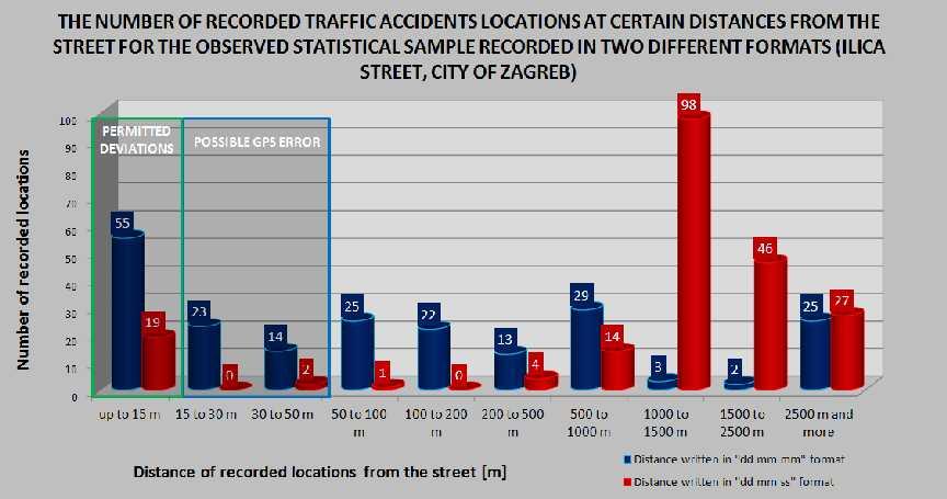
15 STATISTICAL ANALYSIS OF ACTUAL TRAFFIC ACCIDENT DATA Variance analysis of all 211 locations of traffic accidents compared to the observed corridor of the street was conducted separately for two different formats of the location coordinates. The analysis results confirmed that the coordinates of traffic locations accidents are recorded in two different formats which include ''DD MM.MMM'' and ''DD MM SSS'' format. Statistical analysis indicates that about 42% of the sample locations of traffic accidents are recorded in first of the above mentioned formats, while 10% of the sample was recorded in the second format type. Remaining percentage of about 48% of data is recorded in either of the two mentioned formats. 15


16 GIS analysis of actual traffic accident data Fig. 3 Map representation of Ilica traffic accidents locations corresponding to actual Ilica street corridor and permitted error spatial buffer. DD MM SS.S format 16


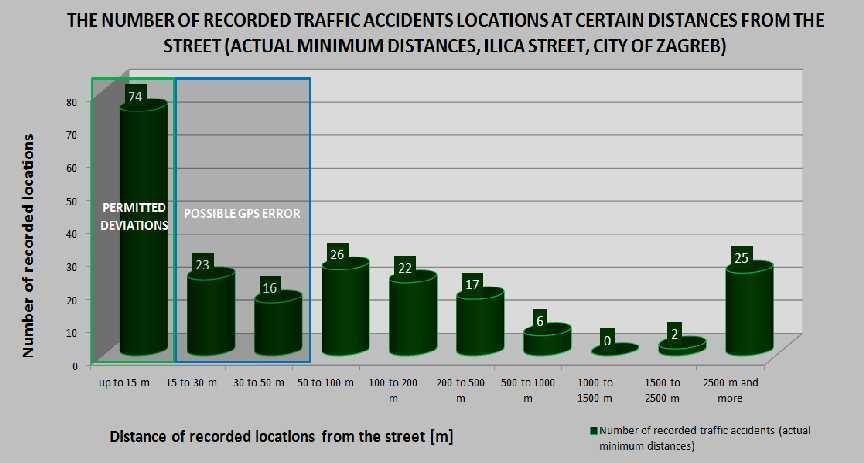
17 STATISTICAL ANALYSIS OF ACTUAL TRAFFIC ACCIDENT DATA All traffic accidents, which are located in the corridor of the street with total width of 30 m, are considered to be accurately defined locations and within 50m as possibly accurate. The remaining part of the statistical sample includes locations with unacceptable deviation from the actual geographic location of traffic accidents. 17

18 STATISTICAL ANALYSIS OF ACTUAL TRAFFIC ACCIDENT DATA For the purpose of detailed statistical analysis and the representation of the inaccuracies of recorded traffic accidents locations, a total of 10 statistical classes were defined. Statistical classes actually represent the distances of traffic accidents locations in relation to observed street corridor. Based on these analysis results it was found that from total number of recorded traffic accidents locations only about 35% are located in allowed margins of error. The remaining locations in the sample which include approximately 65% of recorded traffic accidents locations have unacceptable deviation from the actual geographical position of traffic accident. These results emphasize the need to upgrade and improve existing systems for locating traffic accidents as well as collection and recording of all relevant data. 18


19 STATISTICAL ANALYSIS OF ACTUAL TRAFFIC ACCIDENT DATA 19


20 STATISTICAL ANALYSIS OF ACTUAL TRAFFIC ACCIDENT DATA 20


21 CONCLUSION AND RECOMMENDATIONS Data analysis of traffic accidents spatial distribution in Croatia for 2010 shows that large numbers of traffic accident locations are recorded incorrectly in the official database. Need for improvement in the existing system and procedures for locating traffic accidents as well as additional data verification procedures. Recording traffic accidents location with coordinates in different formats causes significant errors when mapping the spatial distribution of the traffic accidents Inaccuracy in determining the traffic accident location arises due to insufficient training of police officers The problem of the current traffic accidents database is that meaningful cartographic representation of the collected data is impossible, which significantly complicates the statistical analysis of the spatial distribution of traffic accidents 21


22 CONCLUSION AND RECOMMENDATIONS Development of System for locating, collecting, analyzing and managing traffic accidents based on GIS platform Improvement in education of police officers GREATER ACCURACY AND INCREASED QUALITY OF COLLECTED DATA Improvement of the existing database of traffic accidents Application of the mobile data terminal for accurate georeferencing of occurred traffic accident. Application of geocoding and geo-verification of the relevant descriptive attributes Application of fixed GPS receivers capable of showing the vehicle's position in real time on a GIS map contained in the Mobile Data Terminal 22


23 23
Black Spot Determination of Traffic Accident Locations and Its Spatial Association Characteristic Analysis Based on GIS
 Journal of Geographic Information System, 212, 4, 68-617 http://dx.doi.org/1.4236/jgis.212.4663 Published Online December 212 (http://www.scirp.org/journal/jgis) Black Spot Determination of Traffic Accident
Key Steps for Assessing Mission Critical Data for An ebook by Geo-Comm, Inc.
 Key Steps for Assessing Mission Critical Data for 9-1-1 An ebook by Geo-Comm, Inc. If you re reading this, you probably understand transitioning to Next Generation 9-1-1 (NG9-1-1) means your Geographic
Geospatial Big Data Analytics for Road Network Safety Management
 Proceedings of the 2018 World Transport Convention Beijing, China, June 18-21, 2018 Geospatial Big Data Analytics for Road Network Safety Management ABSTRACT Wei Liu GHD Level 1, 103 Tristram Street, Hamilton,
Spatiotemporal Analysis of Urban Traffic Accidents: A Case Study of Tehran City, Iran
 Spatiotemporal Analysis of Urban Traffic Accidents: A Case Study of Tehran City, Iran January 2018 Niloofar HAJI MIRZA AGHASI Spatiotemporal Analysis of Urban Traffic Accidents: A Case Study of Tehran
Research on Topographic Map Updating
 Research on Topographic Map Updating Ivana Javorovic Remote Sensing Laboratory Ilica 242, 10000 Zagreb, Croatia Miljenko Lapaine University of Zagreb, Faculty of Geodesy Kaciceva 26, 10000 Zagreb, Croatia
ENHANCING ROAD SAFETY MANAGEMENT WITH GIS MAPPING AND GEOSPATIAL DATABASE
 Abstract ENHANCING ROAD SAFETY MANAGEMENT WITH GIS MAPPING AND GEOSPATIAL DATABASE Dr Wei Liu GHD Reliable and accurate data are needed in each stage of road safety management in order to correctly identify
Traffic accidents and the road network in SAS/GIS
 Traffic accidents and the road network in SAS/GIS Frank Poppe SWOV Institute for Road Safety Research, the Netherlands Introduction The first figure shows a screen snapshot of SAS/GIS with part of the
Use of Crash Report Data for Safety Engineering in Small- and Mediumsized
 Use of Crash Report Data for Safety Engineering in Small- and Mediumsized MPOs 2015 AMPO Annual Conference Sina Kahrobaei, Transportation Planner Doray Hill, Jr., Director October 21, 2015 San Angelo MPO,
Risk Assessment of Pedestrian Accident Area Using Spatial Analysis and Deep Learning
 Risk Assessment of Pedestrian Accident Area Using Spatial Analysis and Deep Learning Ilyoung Hong*, Hanseung Choi, Songpyo Hong Department of GIS Engineering, Namseoul University, Republic of Korea. *
The Framework and Application of Geographic Information Systems (GIS)
") The Framework and Application of Geographic Information Systems (GIS) The Framework and Application of Geographic Information Systems (GIS) Part I The Geographic Framework The Geographic Framework Spatial
The Framework and Application of Geographic Information Systems (GIS) The Framework and Application of Geographic Information Systems (GIS) Part I The Geographic Framework The Geographic Framework Spatial
Chancellor s Memorandum CM-64 Tornado Policy
 Chancellor s Memorandum CM-64 Tornado Policy To: Vice Chancellors, Deans, Administrative Staff, and Department Heads. From: LSU Health Sciences Center New Orleans Chancellor July 11, 2017 Revised on September
GIS TECHNICIAN I GIS TECHNICIAN II
 GIS TECHNICIAN I GIS TECHNICIAN II CITY OF ROSEVILLE DEFINITION To perform a variety of technical office and field work duties related to the creation and maintenance of maps, tables, graphs and other
FIRE DEPARMENT SANTA CLARA COUNTY
 DEFINITION FIRE DEPARMENT SANTA CLARA COUNTY GEOGRAPHIC INFORMATION SYSTEM (GIS) ANALYST Under the direction of the Information Technology Officer, the GIS Analyst provides geo-spatial strategic planning,
The Use of Geographic Information Systems (GIS) by Local Governments. Giving municipal decision-makers the power to make better decisions
 by Local Governments. Giving municipal decision-makers the power to make better decisions") The Use of Geographic Information Systems (GIS) by Local Governments Giving municipal decision-makers the power to make better decisions Case Study: Examples of GIS Usage by Local Governments in North
The Use of Geographic Information Systems (GIS) by Local Governments Giving municipal decision-makers the power to make better decisions Case Study: Examples of GIS Usage by Local Governments in North
Enhance Security, Safety and Efficiency With Geospatial Visualization
 Areas within 10 minutes of an exit are emphasized on this map, to give an indication of how accessible neighborhoods are by highway. The colors represent 1, 3, 5 and 10 minute increments from the exits.
GIS ANALYSIS METHODOLOGY
 GIS ANALYSIS METHODOLOGY No longer the exclusive domain of cartographers, computer-assisted drawing technicians, mainframes, and workstations, geographic information system (GIS) mapping has migrated to
Texas A&M University
 Texas A&M University CVEN 658 Civil Engineering Applications of GIS Hotspot Analysis of Highway Accident Spatial Pattern Based on Network Spatial Weights Instructor: Dr. Francisco Olivera Author: Zachry
CENSUS MAPPING WITH GIS IN NAMIBIA. BY Mrs. Ottilie Mwazi Central Bureau of Statistics Tel: October 2007
 CENSUS MAPPING WITH GIS IN NAMIBIA BY Mrs. Ottilie Mwazi Central Bureau of Statistics E-mail: omwazi@npc.gov.na Tel: + 264 61 283 4060 October 2007 Content of Presentation HISTORICAL BACKGROUND OF CENSUS
3.2 CONGESTIONS AND INTERSECTIONS OF CRITICAL INFRASTRUCTURE
 3.2 CONGESTIONS AND INTERSECTIONS OF CRITICAL INFRASTRUCTURE Authors: dr. Iztok PREZELJ Marko FATUR Marjan LENARČIČ Špela LOŽAR Roman PLEŠKO CONCEPT OF GEOGRAPHIC INTERDEPENDENCIES OF CRITICAL INFRASTRUCTURES
PRIORITIZATION OF ACCIDENT BLACK SPOTS USING GIS
 Website: www.ijetae.com (ISSN 50-59, Volume, Issue 9, September 01) PRIORITIZATION OF ACCIDENT BLACK SPOTS USING GIS Reshma E.K 1, Sheikh Umar Sharif 1 Professor, Student, Civil Engineering Dept., Dayananda
Land Navigation Table of Contents
 Land Navigation Table of Contents Preparatory Notes to Instructor... 1 Session Notes... 5 Learning Activity: Grid Reference Four Figure... 7 Learning Activity: Grid Reference Six Figure... 8 Learning Activity:
UN-GGIM: User case studies ISRAEL
 UNGGIM: User case studies ISRAEL ISRAEL GIS for 2008 Integrated Population Census GIS was used as a main infrastructure for the 2008 Israeli integrated census of population The Integrated Census is based
GIS Geographical Information Systems. GIS Management
 GIS Geographical Information Systems GIS Management Difficulties on establishing a GIS Funding GIS Determining Project Standards Data Gathering Map Development Recruiting GIS Professionals Educating Staff
THE DEVELOPMENT OF ROAD ACCIDENT DATABASE MANAGEMENT SYSTEM FOR ROAD SAFETY ANALYSES AND IMPROVEMENT
 THE DEVELOPMENT OF ROAD ACCIDENT DATABASE MANAGEMENT SYSTEM FOR ROAD SAFETY ANALYSES AND IMPROVEMENT By T. H. Law Radin Umar R. S. (Road Safety Research Center, Faculty of Engineering, University Putra
Data Driven Approaches to Crime and Traffic Safety
 Data Driven Approaches to Crime and Traffic Safety Baltimore County Police Department Traffic Safety is Public Safety Baltimore County Police Department Population: 801,000 Square Miles: 610 Sworn Personnel:
How GIS Can Help With Tribal Safety Planning
 How GIS Can Help With Tribal Safety Planning Thomas A. Horan, PhD Brian Hilton, PhD Arman Majidi, MAIS Center for Information Systems and Technology Claremont Graduate University Goals & Objectives This
Unit 1, Lesson 2. What is geographic inquiry?
 What is geographic inquiry? Unit 1, Lesson 2 Understanding the way in which social scientists investigate problems will help you conduct your own investigations about problems or issues facing your community
Urban Traffic Speed Management: The Use of GPS/GIS
 Urban Traffic Speed Management: The Use of GPS/GIS Keywords: Speed Management, Traffic Congestion, Urban Traffic Flow, Geographical Information System (GIS), Global Positioning System (GPS) SUMMARY The
STATISTICAL ANALYSIS OF LAW ENFORCEMENT SURVEILLANCE IMPACT ON SAMPLE CONSTRUCTION ZONES IN MISSISSIPPI (Part 1: DESCRIPTIVE)
") STATISTICAL ANALYSIS OF LAW ENFORCEMENT SURVEILLANCE IMPACT ON SAMPLE CONSTRUCTION ZONES IN MISSISSIPPI (Part 1: DESCRIPTIVE) Tulio Sulbaran, Ph.D 1, David Marchman 2 Abstract It is estimated that every
STATISTICAL ANALYSIS OF LAW ENFORCEMENT SURVEILLANCE IMPACT ON SAMPLE CONSTRUCTION ZONES IN MISSISSIPPI (Part 1: DESCRIPTIVE) Tulio Sulbaran, Ph.D 1, David Marchman 2 Abstract It is estimated that every
HIGH RESOLUTION BASE MAP: A CASE STUDY OF JNTUH-HYDERABAD CAMPUS
 HIGH RESOLUTION BASE MAP: A CASE STUDY OF JNTUH-HYDERABAD CAMPUS K.Manjula Vani, Abhinay Reddy, J. Venkatesh, Ballu Harish and R.S. Dwivedi ABSTRACT The proposed work High Resolution Base map: A Case study
Applications of GIS in Electrical Power System. Dr. Baqer AL-Ramadan Abdulrahman Al-Sakkaf
 Applications of GIS in Electrical Power System Dr. Baqer AL-Ramadan Abdulrahman Al-Sakkaf OUTLINES: Objective Importance of GIS GIS data development Application of GIS Findings Conclusions and Recommendations
The project, born from an idea of the Provincial College of the Surveyors of Trapani and from the synergy between the administration of Mazara del
 The project, born from an idea of the Provincial College of the Surveyors of Trapani and from the synergy between the administration of Mazara del Vallo, with the Surveyors Professional Organizations :
Economic and Social Council
 United Nations Economic and Social Council Distr.: General 23 May 2012 Original: English E/CONF.101/100 Tenth United Nations Conference on the Standardization of Geographical Names New York, 31 July 9
GIS (GEOGRAPHIC INFORMATION SYSTEMS)
") GIS (GEOGRAPHIC INFORMATION SYSTEMS) 1 1. DEFINITION SYSTEM Any organised assembly of resources and procedures united and regulated by interaction or interdependence to complete a set of specific functions.
GIS (GEOGRAPHIC INFORMATION SYSTEMS) 1 1. DEFINITION SYSTEM Any organised assembly of resources and procedures united and regulated by interaction or interdependence to complete a set of specific functions.
Disaster Management in Republic of Korea
 The Third UN-GGIM-AP Plenary Meeting Disaster Management in Republic of Korea ~Coordination among NGIA & Other Related Organizations and Recommendations~ Bali Indonesia 10 November 2014 Sanghoon Lee, Ph.D.
Applications of GIS in Electrical Power System
 Applications of GIS in Electrical Power System Abdulrahman M. AL-Sakkaf 201102310 CRP 514 May 2013 Dr. Baqer M. AL-Ramadan Abstract GIS has been widely used in various areas and disciplines. This paper
John Laznik 273 Delaplane Ave Newark, DE (302)
") Office Address: John Laznik 273 Delaplane Ave Newark, DE 19711 (302) 831-0479 Center for Applied Demography and Survey Research College of Human Services, Education and Public Policy University of Delaware
Office Address: John Laznik 273 Delaplane Ave Newark, DE 19711 (302) 831-0479 Center for Applied Demography and Survey Research College of Human Services, Education and Public Policy University of Delaware
The Road to Improving your GIS Data. An ebook by Geo-Comm, Inc.
 The Road to Improving your GIS Data An ebook by Geo-Comm, Inc. An individual observes another person that appears to be in need of emergency assistance and makes the decision to place a call to 9-1-1.
Steve Pietersen Office Telephone No
 Steve Pietersen Steve.Pieterson@durban.gov.za Office Telephone No. 031 311 8655 Overview Why geography matters The power of GIS EWS GIS water stats EWS GIS sanitation stats How to build a GIS system EWS
Application of GIS in Public Transportation Case-study: Almada, Portugal
 Case-study: Almada, Portugal Doutor Jorge Ferreira 1 FSCH/UNL Av Berna 26 C 1069-061 Lisboa, Portugal +351 21 7908300 jr.ferreira@fcsh.unl.pt 2 FSCH/UNL Dra. FCSH/UNL +351 914693843, leite.ines@gmail.com
Gis for Land Management: An Overview on Italy
 Gis for Land Management: An Overview on Italy Paola RONZINO, Italy Key words: Cartography, Land Management, Spatial Planning, Urban Renewal, Spatial Information, Environment SUMMARY The introduction of
GIS FOR MAZOWSZE REGION - GENERAL OUTLINE
 GIS FOR MAZOWSZE REGION - GENERAL OUTLINE S. Bialousz 1), K Mączewski 2), E. Janczar 2), K. Osinska-Skotak 1) 1) Warsaw University of Technology, Warsaw, Poland 2) Office of the Surveyor of the Mazowieckie
BOWIE SENIORS COMPUTER CLUB
 BOWIE SENIORS COMPUTER CLUB Meeting Minutes for May 5, 2016 Through the efforts of Program Chairman Dan Lee, we had Patrick T. Callahan, GIS Manager of the Prince George's County Office of Information
LEADS. The Essential Elements of a 3-D Geographic Coordinate
 The Essential Elements of a 3-D Geographic Coordinate John W. Dix 13 September 2005 ESRI Homeland Security GIS Summit - Denver, CO John.W.Dix@nga.mil NATIONAL GEOSPATIAL-INTELLIGENCE AGENCY Overview is
National Park Service Safety Management
 National Park Service Safety Management Locating Crashes Spatially from the National Park Service Service-wide Traffic Accident Reporting System (STARS) Database By Daniel Van Gilder Federal Highway Administration
Emergency Action Guidelines for NH 4-H Animal Events
 Emergency Action Guidelines for NH 4-H Animal Events Purpose: This plan outlines guidelines designed to help ensure NH 4-H Animal Events and Shows are prepared for emergencies and severe weather conditions.
GIS Needs Assessment. for. The City of East Lansing
 GIS Needs Assessment for The City of East Lansing Prepared by: Jessica Moy and Richard Groop Center for Remote Sensing and GIS, Michigan State University February 24, 2000 Executive Summary At the request
Abstract: Traffic accident data is an important decision-making tool for city governments responsible for
 Kalen Myers, GIS Analyst 1100 37 th St Evans CO, 80620 Office: 970-475-2224 About the Author: Kalen Myers is GIS Analyst for the City of Evans Colorado. She has a bachelor's degree from Temple University
APPLICATION OF GIS IN ELECTRICAL DISTRIBUTION NETWORK SYSTEM
 See discussions, stats, and author profiles for this publication at: https://www.researchgate.net/publication/305263658 APPLICATION OF GIS IN ELECTRICAL DISTRIBUTION NETWORK SYSTEM Article October 2015
INDOT Office of Traffic Safety
 Intro to GIS Spatial Analysis INDOT Office of Traffic Safety Intro to GIS Spatial Analysis INDOT Office of Traffic Safety Kevin Knoke Section 130 Program Manager Highway Engineer II Registered Professional
S/He reports to the Programme Effectiveness Manager. Lead, review and process the development of NO GIS framework and tools.
 GIS Coordinator Location: [Africa] [Ghana] Town/City: Accra Category: Knowledge Management GIS Coordinator To provide leadership and management to cluster staff (of 2 to 3 Area Programs) by ensuring that
Capturing and recording spatial data Guidelines, standards and best practices
 Capturing and recording spatial data Guidelines, standards and best practices February 2018 Established by Technical Note Author David Taylor, Data4FI, insight2impact About insight2impact Insight2impact
Land Use in the context of sustainable, smart and inclusive growth
 Land Use in the context of sustainable, smart and inclusive growth François Salgé Ministry of sustainable development France facilitator EUROGI vice president AFIGéO board member 1 Introduction e-content+
ADMINISTRATION BUILDING
 TORNADO PROCEDURES Tornadoes are nature s most violent storms, and over a small area, the most destructive. A tornado s whirling winds may reach 300 miles per hour or more. Generally short-lived and fast
OXFORD HEIGHTS SUBDIVISION EMERGENCY EVACUATION PLAN
 OXFORD HEIGHTS SUBDIVISION EMERGENCY EVACUATION PLAN March 27, 2007 Oxford Heights Overview and Historical Conditions Oxford Heights is a medium sized community located on the southern side of Elizabeth
List of Legislative Regulations Dealing with Nuclear Energy and Ionizing Radiation and Related Documents
 List of Legislative Regulations Dealing with Nuclear Energy and Ionizing Radiation and Related Documents as on 18 June 2001 I. Atomic Act and Related Implementing Regulations a) Atomic Act 1. Act No. 18/1997
Extraction of Accidents Prediction Maps Modeling Hot Spots in Geospatial Information System
 Extraction of Accidents Prediction Maps Modeling Hot Spots in Geospatial Information System R.Shad a, *, A. Mesgar b, R. Moghimi b a Rouzbeh Shad, Assistant professor, Civil Department, Ferdowsi University
DECISION SUPPORT SYSTEMS FOR PARTICIPATORY FLOOD RISK AND DISASTER MANAGEMENT
 DECISION SUPPORT SYSTEMS FOR PARTICIPATORY FLOOD RISK AND DISASTER MANAGEMENT PhD Thesis Panayiotis Sophronides, Dipl.-Ing., MSc & DIC, PhD Candidate Advisory committee: Prof. Maria Giaoutzi (Supervisor),
DEVELOPMENT OF TRAFFIC ACCIDENT ANALYSIS SYSTEM USING GIS
 DEVELOPMENT OF TRAFFIC ACCIDENT ANALYSIS SYSTEM USING GIS Masayuki HIRASAWA Researcher Traffic Engineering Division Civil Engineering Research Institute of Hokkaido 1-3 Hiragishi, Toyohira-ku, Sapporo,
A Technique for Importing Shapefile to Mobile Device in a Distributed System Environment.
 A Technique for Importing Shapefile to Mobile Device in a Distributed System Environment. 1 Manish Srivastava, 2 Atul Verma, 3 Kanika Gupta 1 Academy of Business Engineering and Sciences,Ghaziabad, 201001,India
Application of GIS and Remote Sensing Approach for the Analysis of Asaba Urban Street Network of Delta State, Nigeria
 International Journal of Advances in Scientific Research and Engineering (ijasre) E-ISSN : 2454-8006 DOI: http://dx.doi.org/10.7324/ijasre.2018.32592 Volume 4, Issue 1 January-2018 Application of GIS and
Winter weather and municipal winter road maintenance
 Winter weather and municipal winter road maintenance Marie Eriksson 1 and Alf Johansson 2 1 Marie Eriksson, PhD, Klimator AB, Earth Sciences Centre, Box 460, SE-405 30 Göteborg, SWEDEN. E-mail: mariee@gvc.gu.se,
National Cartographic Center
 National Cartographic Center NCC activities and accomplishments Activities of national organizations, institutions and universities in field of geomatics Large scale maps Medium scale maps Small scale
Developing Database and GIS (First Phase)
") 13.3 Developing Database and GIS (First Phase) 13.3.1 Unifying GIS Coordinate System There are several data sources which have X, Y coordinate. In one study, UTM is used, in the other study, geographic
13.3 Developing Database and GIS (First Phase) 13.3.1 Unifying GIS Coordinate System There are several data sources which have X, Y coordinate. In one study, UTM is used, in the other study, geographic
ABSTRACT The first chapter Chapter two Chapter three Chapter four
 ABSTRACT The researches regarding this doctoral dissertation have been focused on the use of modern techniques and technologies of topography for the inventory and record keeping of land reclamation. The
How GIS can be used for improvement of literacy and CE programmes
 How GIS can be used for improvement of literacy and CE programmes Training Workshop for Myanmar Literacy Resource Center (MLRC) ( Yangon, Myanmar, 11 20 October 2000 ) Presented by U THEIN HTUT GEOCOMP
Progress Report. Flood Hazard Mapping in Thailand
 Progress Report Flood Hazard Mapping in Thailand Prepared By: Mr. PAITOON NAKTAE Chief of Safety Standard sub-beuro Disaster Prevention beuro Department of Disaster Prevention and Mitigation THAILAND E-mail:
inovitas be on site with infra3d
 inovitas be on site with infra3d be inspired... Infrastructure has an immense property value and is a prerequisite for a functioning competitive economy. In this context, the modes of transport such as
DP Project Development Pvt. Ltd.
 Dear Sir/Madam, Greetings!!! Thanks for contacting DP Project Development for your training requirement. DP Project Development is leading professional training provider in GIS technologies and GIS application
ANALYSIS OF INTRINSIC FACTORS CONTRIBUTING TO URBAN ROAD CRASHES
 S. Raicu, et al., Int. J. of Safety and Security Eng., Vol. 7, No. 1 (2017) 1 9 ANALYSIS OF INTRINSIC FACTORS CONTRIBUTING TO URBAN ROAD CRASHES S. RAICU, D. COSTESCU & S. BURCIU Politehnica University
A COMPARATIVE STUDY OF THE APPLICATION OF THE STANDARD KERNEL DENSITY ESTIMATION AND NETWORK KERNEL DENSITY ESTIMATION IN CRASH HOTSPOT IDENTIFICATION
 A COMPARATIVE STUDY OF THE APPLICATION OF THE STANDARD KERNEL DENSITY ESTIMATION AND NETWORK KERNEL DENSITY ESTIMATION IN CRASH HOTSPOT IDENTIFICATION Yue Tang Graduate Research Assistant Department of
USAGE OF SPATIAL TECHNOLOGY IN EMERGENCY MAPPING
 USAGE OF SPATIAL TECHNOLOGY IN EMERGENCY MAPPING Nandakumar Thananjeyan Former UN staff member, Sri Lanka nthananjeyan@gmail.com ABSTRACT: This paper reports on the findings of a study to use of GIS, Remote
Snow and Ice Control POLICY NO. P-01/2015. CITY OF AIRDRIE Snow and Ice Control Policy
 Page 1 CITY OF AIRDRIE Snow and Ice Control Effective Date: Approved By: Approved On: March 17, 2015 City Council March 16, 2015 Revision Date: Resolution #: ------ PURPOSE: The City of Airdrie is responsible
CITY OF EAST PEORIA SNOW AND ICE CONTROL PROGRAM INTRODUCTION
 CITY OF EAST PEORIA SNOW AND ICE CONTROL PROGRAM INTRODUCTION The responsibility for providing snow and ice control on East Peoria s 240 lane miles of streets and alleys rests with the Street Divisions
Optimizing work processes by using GIS in the ASFINAG. Peter Aubrecht ASFINAG Service GmbH, AUSTRIA EUC Croatia, Split 15 th October 2014
 Optimizing work processes by using GIS in the ASFINAG Peter Aubrecht ASFINAG Service GmbH, AUSTRIA EUC Croatia, Split 15 th October 2014 AGENDA The ASFINAG Group: Organisation and Tasks The ASFINAG Road
13.2 USING VIRTUAL GLOBES TO IMPROVE SITUATIONAL AWARENESS IN THE NATIONAL WEATHER SERVICE
 13.2 USING VIRTUAL GLOBES TO IMPROVE SITUATIONAL AWARENESS IN THE NATIONAL WEATHER SERVICE Andy Foster* National Weather Service Springfield, Missouri* Keith Stellman National Weather Service Shreveport,
Montgomery County Community College GEO 210 Introduction to Geographic Information Systems (GIS) 3-2-2
 3-2-2") Montgomery County Community College GEO 210 Introduction to Geographic Information Systems (GIS) 3-2-2 COURSE DESCRIPTION: This introduction to Geographic Information Systems is structured to develop skills
Montgomery County Community College GEO 210 Introduction to Geographic Information Systems (GIS) 3-2-2 COURSE DESCRIPTION: This introduction to Geographic Information Systems is structured to develop skills
Unit 1, Lesson 3 What Tools and Technologies Do Geographers Use?
 Unit 1, Lesson 3 What Tools and Technologies Do Geographers Use? Geographers use a variety of tools and technologies in investigating geographic questions. Maps and globes both represent the earth, but
FHWA GIS Outreach Activities. Loveland, Colorado April 17, 2012
 FHWA GIS Outreach Activities Loveland, Colorado April 17, 2012 GIS for Improved Decision Making FHWA believes that geographic information systems and other geospatial technologies (remote sensing and GPS)
CITY OF NEW LONDON WINTER ROAD & SIDEWALK MAINTENANCE POLICY
 CITY OF NEW LONDON WINTER ROAD & SIDEWALK MAINTENANCE POLICY GENERAL The purpose of this policy is to set up acceptable procedures and policies for the winter maintenance of public areas in the City of
John A. Carlson Snow and Ice Removal
 John A. Carlson Snow and Ice Removal A. Introduction 1. The purpose of the Snow and Ice Removal Operation Plan is to provide all personnel who are involved in snow and ice removal a single source document,
Towards Reliable Spatial Database of Informal Areas in Greater Cairo Region
 KEYWORDS informal areas, unreliable spatial data, spatial data collecting, capacity building SUMMARY The uncontrolled and rapid increase of Egypt s cities is a major problem of the country. More than the
Safety Regions, GIS and DM & Better SA by improved textual- & spatial visualisation. Jaap Smit Information Manager GEO, Safety Region IJsselland
 Safety Regions, GIS and DM & Better SA by improved textual- & spatial visualisation Jaap Smit Information Manager GEO, Safety Region IJsselland The Netherlands Area: 41,543 km 2 16,039 sq. mi Population:
Digitization in a Census
 Topics Connectivity of Geographic Data Sketch Maps Data Organization and Geodatabases Managing a Digitization Project Quality and Control Topology Metadata 1 Topics (continued) Interactive Selection Snapping
Application of GIS to Traffic Accident Analysis: Case Study of Naypyitaw-Mandalay Expressway (Myanmar)
") Application of GIS to Traffic Accident Analysis: Case Study of Naypyitaw-Mandalay Expressway (Myanmar) Kyaw Zin Htut a, Ei Ei Mon b, Leonard Johnstone c, Rattaphol Pueboobpaphan d, Vatanavongs Ratanavaraha
Application of GIS to Traffic Accident Analysis: Case Study of Naypyitaw-Mandalay Expressway (Myanmar) Kyaw Zin Htut a, Ei Ei Mon b, Leonard Johnstone c, Rattaphol Pueboobpaphan d, Vatanavongs Ratanavaraha
THE 3D SIMULATION INFORMATION SYSTEM FOR ASSESSING THE FLOODING LOST IN KEELUNG RIVER BASIN
 THE 3D SIMULATION INFORMATION SYSTEM FOR ASSESSING THE FLOODING LOST IN KEELUNG RIVER BASIN Kuo-Chung Wen *, Tsung-Hsing Huang ** * Associate Professor, Chinese Culture University, Taipei **Master, Chinese
If you aren t familiar with Geographical Information Systems (GIS), you. GIS, when combined with a database that stores response information,
, you. GIS, when combined with a database that stores response information,") Geographical Information Systems in EMS By William E. Ott If you aren t familiar with Geographical Information Systems (GIS), you should take a look at what GIS can offer you as an EMS manager. GIS, when
Geographical Information Systems in EMS By William E. Ott If you aren t familiar with Geographical Information Systems (GIS), you should take a look at what GIS can offer you as an EMS manager. GIS, when
Raising awareness about advantages of standardization of geographical names / Des avantages de la normalisation
 Madagascar, 2013 Raising awareness about advantages of standardization of geographical names / Des avantages de la normalisation Helen Kerfoot Past Chair, UNGEGN (2002-2012) (Natural Resources Canada)
Martin MENSA, Eli SABLAH, Emmanuel AMAMOO-OTCHERE and Foster MENSAH, Ghana. Key words: Feeder Roads Condition Survey, Database Development
 Digital Mapping and GIS-Driven Feeder Road Network Database Management System for Road Project Planning and Implementation Monitoring in the Feeder Road Sector Martin MENSA, Eli SABLAH, Emmanuel AMAMOO-OTCHERE
Lecture 9: Geocoding & Network Analysis
 Massachusetts Institute of Technology - Department of Urban Studies and Planning 11.520: A Workshop on Geographic Information Systems 11.188: Urban Planning and Social Science Laboratory Lecture 9: Geocoding
JOB DESCRI PTI ON. GIS Administrator
 JOB DESCRI PTI ON JOB GRADE: GS-0 Cla ss Code : Office - 8 8 0 DEPARTMENT: 2 0 - FLSA: EXEMPT JOB NO: 6-0 9-2 7 SALARY: To Be De t e rm in e d Job description statements are intended to describe the general
FIG WW Evaluation of Mobile Mapping System (MMS) Survey for Public Housing Estates in Hong Kong. Winnie SHIU. Senior Land Surveyor.
 Survey for Public Housing Estates in Hong Kong. Winnie SHIU. Senior Land Surveyor.") FIG WW 2012 Evaluation of Mobile Mapping System (MMS) Survey for Public Housing Estates in Hong Kong Winnie SHIU Senior Land Surveyor 9 May 2012 Housing Department 1953 Big Fire in Squatter Area Constructed
FIG WW 2012 Evaluation of Mobile Mapping System (MMS) Survey for Public Housing Estates in Hong Kong Winnie SHIU Senior Land Surveyor 9 May 2012 Housing Department 1953 Big Fire in Squatter Area Constructed
Mitigation planning in Epirus- The case of frost and snowfalls. Thematic seminar Epirus September 2011
 Mitigation planning in Epirus- The case of frost and snowfalls Thematic seminar Epirus September 2011 1 Structure of Mitigation Planning in Greece First Level: General Plan for Civil Protection Ksenokratis
Turkey National Report
 UNITED NATIONS Working Paper GROUP OF EXPERTS ON No. 26 GEOGRAPHICAL NAMES Twenty-third Session Vienna, 28 March 4 April 2006 Item 5 of the Provisional Agenda: Reports of the division Turkey National Report
R E SEARCH HIGHLIGHTS
 Canada Research Chair in Urban Change and Adaptation R E SEARCH HIGHLIGHTS PANHANDLING IN WINNIPEG PROJECT: MAPPING METHODOLOGY Research Highlight No. 11 June 2007 Introduction The general methodology
GIS and Remote Sensing Support for Evacuation Analysis
 GIS and Remote Sensing Support for Evacuation Analysis Presented to GIS for Transportation Symposium Rapid City, South Dakota March 28-31, 2004 Demin Xiong Oak Ridge National Laboratory 2360 Cherahala
UNITED NATIONS E/CONF.96/CRP. 5
 UNITED NATIONS E/CONF.96/CRP. 5 ECONOMIC AND SOCIAL COUNCIL Eighth United Nations Regional Cartographic Conference for the Americas New York, 27 June -1 July 2005 Item 5 of the provisional agenda* COUNTRY
GREEN SHEET. California Department of Forestry and Fire Protection (CAL FIRE)
") GREEN SHEET California Department of Forestry and Fire Protection (CAL FIRE) Informational Summary Report of Serious CAL FIRE Injuries, Illnesses, Accidents and Near Serious Accidents Fire Engine Rollover
GREEN SHEET California Department of Forestry and Fire Protection (CAL FIRE) Informational Summary Report of Serious CAL FIRE Injuries, Illnesses, Accidents and Near Serious Accidents Fire Engine Rollover
Using a K-Means Clustering Algorithm to Examine Patterns of Pedestrian Involved Crashes in Honolulu, Hawaii
 Journal of Advanced Transportation, Vol. 41, No. 1, pp. 69-89 www.advanced-transport.com Using a K-Means Clustering Algorithm to Examine Patterns of Pedestrian Involved Crashes in Honolulu, Hawaii Karl
arxiv: v1 [cs.cv] 28 Nov 2017
![arxiv: v1 [cs.cv] 28 Nov 2017](/thumbs/90/103039080.jpg "arxiv: v1 [cs.cv] 28 Nov 2017") A fatal point concept and a low-sensitivity quantitative measure for traffic safety analytics arxiv:1711.10131v1 [cs.cv] 28 Nov 2017 Shan Suthaharan Department of Computer Science University of North Carolina
A fatal point concept and a low-sensitivity quantitative measure for traffic safety analytics arxiv:1711.10131v1 [cs.cv] 28 Nov 2017 Shan Suthaharan Department of Computer Science University of North Carolina