Multi-temporal remote sensing for spatial estimation of Plant Available Water holding Capacity (PAWC)
|
|
|
- Jeffrey Brown
- 5 years ago
- Views:
Transcription
1 NDVI Time Geosmart Asia Locate April 2018 Multi-temporal remote sensing for spatial estimation of Plant Available Water holding Capacity (PAWC) Sofanit Araya Bertram Ostendorf Gregory Lyle Megan Lewis Spatial Information Group (SIG) School of Biological Sciences
 - Lower limit (wilting Point). Source: http://www.regional.org.au/")
2 Background Plant Available Water Capacity (PAWC)- Bucket size of a soil Total amount of water available for crops that the soil can store Upper storage limit (saturation) - Lower limit (wilting Point). Source:

3 Background Plant Available Water Capacity (PAWC)- Spatially highly variable => high growth and yield variability In Mediterranean environment differences in PAWC explained a large portion of crop yield variability (Hall et al., 2009)
4 Background Plant Available Water Capacity (PAWC)- Temporally - strong interaction with climate => yield and growth pattern variability from year to year- flip flop scenario High Low Interaction with rainfall amount and seasonality PAWC modulates the vegetation response to climatic variability (Boydell et al., 2001)
5 Existing PAWC data in SA The two most used available PAWC data in South Australia: Landscape-scale PAWC map 32 0'0"S Soil landscape map of South Australia 1:100,000 (Hall et al., 2009) 34 0'0"S Legend 36 0'0"S >100 mm mm mm mm <20 mm 38 0'0"S Kilometers 135 0'0"E 140 0'0"E APSoil PAWC measurment locations ± 32 0'0"S 34 0'0"S 36 0'0"S Legend APSOIL_SA 38 0'0"S '0"E Kilometers 140 0'0"E APSoil database - Point based database of soil PAWC measurement (


6 Plant Available Water Capacity (PAWC) Measurement Time consuming Relatively expensive Difficult to choice representative soil sampling locations Source: So alternative approach is needed to be used as a surrogate Source:


7 Plant Available Water Capacity (PAWC) Indicators Spatial growth variability or Patchiness Temporal variability So we need to observe Vegetation variability Regular temporal change intra annual time scale Source:

 Regular revisiting")

8 tim e Potential of Remote Sensing Quantify vegetation vigour - Vegetation indices (eg. NDVI) Regular revisiting time Multi- temporal observation => Vegetation growth dynamics Space
9 NDVI Crop phenology from NDVI Time Crop growth dynamics - inform about the environment including water availability, Observations across different climatic conditions (many years) can provide a novel insight about the spatial variability of the underlying soil


10 time Materials and Methods MODIS NDVI - Phenological metrics Temporal - 16 days Spatial - 250m (345 images) Measured Soil PAWC from APSoil ( 256 observation points across SA Rainfall data ( High Spatial resolution of 5km Rainfall data Low


11 NDVI Phenologic metrics Max Value Onset of Greenness Offset of Greenness TINDVI Onset Time Time Max Time A new software package CropPhenology package in R software environment ( Offset Time 15 Metrics are defined
12 Spatial Modelling To assess the relationship between Phenological metrics and PAWC across different climatic conditions - A linear mixed effects model PAWC (Phenologic Metrics, Growing season rainfall, Year, sub region, error ) Where : Max Value and Max Time are phenological metrics, GSRF- growing season rainfall Year the observation year and S a dummy variable representing the subregion of the state Ԑ - an error term
 The higher the PAWC the later the maximum NDVI attained Crop growth under water stress => faster growth")
13 Spatial Modelling Maximum NDVI and Time of Maximum NDVI - Positive correlation with PAWC The higher the PAWC the higher the maximum NDVI High PAWC => more water => high greenness (NDVI) The higher the PAWC the later the maximum NDVI attained Crop growth under water stress => faster growth rate


14 Spatial Modelling Interactions with growing season rainfall indicate stronger relationship at higher rainfall seasons Coincides with previous observation that PAWC Crop growth association is stronger in wet years than dry years.
15 Spatial Estimation


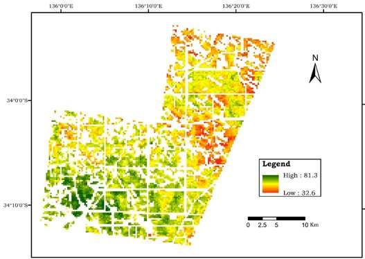
16 34 0'0"S Spatial Estimation Kilometers 34 0'0"S 135 0'0"E Predicted PAWC map 140 0'0"E 0"S 36 0'0"S Legend High : Landscape-scale PAWC map Low : '0"S 0'0"S ± 0"S 38 0'0"S 32 0'0"S Kilometers Landscape-scale PAWC map 32 0'0"S 32 0'0"S 32 0'0"S 0'0"S 0"S 34 0'0"S 34 0'0"S 34 0'0"S 34 0'0"S 0'0"S Legend High : Low : '0"S 0"S 36 0'0"S Legend Legend High Class 1 Class 1 Class 2 Class 3 Class 2 Class 4 Class Low 3 Class 4 Class Kilometers 36 0'0"S 36 0'0"S Kilometers 38 0'0"S Class '0"E Kilometers 140 0'0"E 0'0"S Landscape-scale PAWC map 0"S 135 0'0"E 140 0'0"E 0'0"S
17 Spatial Estimation
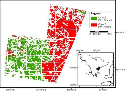
18 Corroboration Challenging! Different method used for creation of these datasets Soil-Landscape map - local knowledge and experience using terrain and air photo interpretation APSoil database - measurements were collected using field and laboratory analysis of soil samples In spite of these difficulty 52% of the pixels were classified into similar categories, with 31% more probability than would have happened by chance.
19 Conclusion There is a consistent soil PAWC signal in the NDVI dynamics, which can be utilized in understanding of variability for agronomic management purpose. The results demonstrate a strong potential of remote sensing derived phenological metrics as indicators for soil PAWC, providing unprecedented spatial detail for digital soil mapping at broad spatial scales. Hence, the presented method can provide an alternative approach for the future broad scale high-resolution soil mapping with the promising advancement of image fusion techniques

20
Stress Deciduous Phenology in the CLM
 Stress Deciduous Phenology in the CLM Kyla Dahlin & Rosie Fisher February 25, 2014 image credit: Forrest Copeland talesfromthebigcountry.wordpress.com Can we accurately model seasonal changes in vegetation
Land cover research, applications and development needs in Slovakia
 Land cover research, applications and development needs in Slovakia Andrej Halabuk Institute of Landscape Ecology Slovak Academy of Sciences (ILE SAS) Štefánikova 3, 814 99 Bratislava, Slovakia Institute
Seasonal and interannual relations between precipitation, soil moisture and vegetation in the North American monsoon region
 Seasonal and interannual relations between precipitation, soil moisture and vegetation in the North American monsoon region Luis A. Mendez-Barroso 1, Enrique R. Vivoni 1, Christopher J. Watts 2 and Julio
Land cover/land use mapping and cha Mongolian plateau using remote sens. Title. Author(s) Bagan, Hasi; Yamagata, Yoshiki. Citation Japan.
 Bagan, Hasi; Yamagata, Yoshiki. Citation Japan.") Title Land cover/land use mapping and cha Mongolian plateau using remote sens Author(s) Bagan, Hasi; Yamagata, Yoshiki International Symposium on "The Imp Citation Region Specific Systems". 6 Nove Japan.
Title Land cover/land use mapping and cha Mongolian plateau using remote sens Author(s) Bagan, Hasi; Yamagata, Yoshiki International Symposium on "The Imp Citation Region Specific Systems". 6 Nove Japan.
Vegetation Remote Sensing
 Vegetation Remote Sensing Huade Guan Prepared for Remote Sensing class Earth & Environmental Science University of Texas at San Antonio November 2, 2005 Outline Why do we study vegetation remote sensing?
ANALYSIS AND VALIDATION OF A METHODOLOGY TO EVALUATE LAND COVER CHANGE IN THE MEDITERRANEAN BASIN USING MULTITEMPORAL MODIS DATA
 PRESENT ENVIRONMENT AND SUSTAINABLE DEVELOPMENT, NR. 4, 2010 ANALYSIS AND VALIDATION OF A METHODOLOGY TO EVALUATE LAND COVER CHANGE IN THE MEDITERRANEAN BASIN USING MULTITEMPORAL MODIS DATA Mara Pilloni
SoilMapp for ipad is a free app that provides soil information at any location in Australia. You can use SoilMapp to:
 About SoilMapp What is SoilMapp? SoilMapp for ipad is a free app that provides soil information at any location in Australia. You can use SoilMapp to: learn about the soil on your property view maps, photographs,
GLOBAL/CONTINENTAL LAND COVER MAPPING AND MONITORING
 GLOBAL/CONTINENTAL LAND COVER MAPPING AND MONITORING Ryutaro Tateishi, Cheng Gang Wen, and Jong-Geol Park Center for Environmental Remote Sensing (CEReS), Chiba University 1-33 Yayoi-cho Inage-ku Chiba
CLICK HERE TO KNOW MORE
 CLICK HERE TO KNOW MORE Geoinformatics Applications in Land Resources Management G.P. Obi Reddy National Bureau of Soil Survey & Land Use Planning Indian Council of Agricultural Research Amravati Road,
Extremes Events in Climate Change Projections Jana Sillmann
 Extremes Events in Climate Change Projections Jana Sillmann Max Planck Institute for Meteorology International Max Planck Research School on Earth System Modeling Temperature distribution IPCC (2001) Outline
DROUGHT ASSESSMENT USING SATELLITE DERIVED METEOROLOGICAL PARAMETERS AND NDVI IN POTOHAR REGION
 DROUGHT ASSESSMENT USING SATELLITE DERIVED METEOROLOGICAL PARAMETERS AND NDVI IN POTOHAR REGION Researcher: Saad-ul-Haque Supervisor: Dr. Badar Ghauri Department of RS & GISc Institute of Space Technology
Data Fusion and Multi-Resolution Data
 Data Fusion and Multi-Resolution Data Nature.com www.museevirtuel-virtualmuseum.ca www.srs.fs.usda.gov Meredith Gartner 3/7/14 Data fusion and multi-resolution data Dark and Bram MAUP and raster data Hilker
The soil depth derived from a grid point augering campaign conducted by the University of Pretoria.
 6. THE SPATIAL DATABASE All the available information considered relevant to the study of the spatial variability of the crop for Pivots Major and Tweefontein has been acquired structured and then stored,
Savannah River Site Mixed Waste Management Facility Southwest Plume Tritium Phytoremediation
 Savannah River Site Mixed Waste Management Facility Southwest Plume Tritium Phytoremediation Evaluating Irrigation Management Strategies Over 25 Years Prepared November 2003 Printed February 27, 2004 Prepared
VILLAGE INFORMATION SYSTEM (V.I.S) FOR WATERSHED MANAGEMENT IN THE NORTH AHMADNAGAR DISTRICT, MAHARASHTRA
 FOR WATERSHED MANAGEMENT IN THE NORTH AHMADNAGAR DISTRICT, MAHARASHTRA") VILLAGE INFORMATION SYSTEM (V.I.S) FOR WATERSHED MANAGEMENT IN THE NORTH AHMADNAGAR DISTRICT, MAHARASHTRA Abstract: The drought prone zone in the Western Maharashtra is not in position to achieve the agricultural
VILLAGE INFORMATION SYSTEM (V.I.S) FOR WATERSHED MANAGEMENT IN THE NORTH AHMADNAGAR DISTRICT, MAHARASHTRA Abstract: The drought prone zone in the Western Maharashtra is not in position to achieve the agricultural
USING HYPERSPECTRAL IMAGERY
 USING HYPERSPECTRAL IMAGERY AND LIDAR DATA TO DETECT PLANT INVASIONS 2016 ESRI CANADA SCHOLARSHIP APPLICATION CURTIS CHANCE M.SC. CANDIDATE FACULTY OF FORESTRY UNIVERSITY OF BRITISH COLUMBIA CURTIS.CHANCE@ALUMNI.UBC.CA
USE OF RADIOMETRICS IN SOIL SURVEY
 USE OF RADIOMETRICS IN SOIL SURVEY Brian Tunstall 2003 Abstract The objectives and requirements with soil mapping are summarised. The capacities for different methods to address these objectives and requirements
METRIC tm. Mapping Evapotranspiration at high Resolution with Internalized Calibration. Shifa Dinesh
 METRIC tm Mapping Evapotranspiration at high Resolution with Internalized Calibration Shifa Dinesh Outline Introduction Background of METRIC tm Surface Energy Balance Image Processing Estimation of Energy
Spatiotemporal variations of alpine climate, snow cover and phenology
 Spatiotemporal variations of alpine climate, snow cover and phenology S. Asam, M. Callegari, M. Matiu, G. Fiore, L. De Gregorio, A. Jacob, A. Menzel, C. Notarnicola, M. Zebisch Asam et al., Spatiotemporal
Chitra Sood, R.M. Bhagat and Vaibhav Kalia Centre for Geo-informatics Research and Training, CSK HPKV, Palampur , HP, India
 APPLICATION OF SPACE TECHNOLOGY AND GIS FOR INVENTORYING, MONITORING & CONSERVATION OF MOUNTAIN BIODIVERSITY WITH SPECIAL REFERENCE TO MEDICINAL PLANTS Chitra Sood, R.M. Bhagat and Vaibhav Kalia Centre
What s the value of rain forecasts for dryland cotton? Preliminary. Rebecca Darbyshire
 What s the value of rain forecasts for dryland cotton? Preliminary Rebecca Darbyshire rebecca.darbyshire@dpi.nsw.gov.au What do you think is your major decision that a seasonal climate forecast would be
Introduction to Satellite Derived Vegetation Indices
 Introduction to the Use of Geospatial Information Technology for Drought Risk Management 13-17 November, 2017 Tonle Bassac II Restaurant, Phnom Penh, Cambodia Introduction to Satellite Derived Vegetation
PLP 6404 Epidemiology of Plant Diseases Spring 2015
 PLP 6404 Epidemiology of Plant Diseases Spring 2015 Ariena van Bruggen, modified from Katherine Stevenson Lecture 8: Influence of host on disease development - plant growth For researchers to communicate
Implementation of CLIMAP and GIS for Mapping the Climatic Dataset of Northern Iraq
 Implementation of CLIMAP and GIS for Mapping the Climatic Dataset of Northern Iraq Sabah Hussein Ali University of Mosul/Remote sensing Center KEYWORDS: CLIMAP, GIS, DEM, Climatic, IRAQ ABSTRACT The main
Agriculture Drought Assessment and Monitoring (ADAMS) Software Using Esri ArcMAP
 Software Using Esri ArcMAP") Agriculture Drought Assessment and Monitoring (ADAMS) Software Using Esri ArcMAP Jeganathan 1, C., Giriraj Amarnath 2, Kirti Avishek 1, Saptarshi Mondal 1, Peejush Pani 2, Salghuna N. N. 1, Niranga Alahacoon
Agriculture Drought Assessment and Monitoring (ADAMS) Software Using Esri ArcMAP Jeganathan 1, C., Giriraj Amarnath 2, Kirti Avishek 1, Saptarshi Mondal 1, Peejush Pani 2, Salghuna N. N. 1, Niranga Alahacoon
Environmental Changes, Migration, and Remittances Affect Pastoralist Communities in Montane Central Asia
 Environmental Changes, Migration, and Remittances Affect Pastoralist Communities in Montane Central Asia Geoffrey M. Henebry * Hannah Visiting Professor Center for Global Change & Earth Observations &
Validating a Satellite Microwave Remote Sensing Based Global Record of Daily Landscape Freeze- Thaw Dynamics
 University of Montana ScholarWorks at University of Montana Numerical Terradynamic Simulation Group Publications Numerical Terradynamic Simulation Group 2012 Validating a Satellite Microwave Remote Sensing
ISO MODIS NDVI Weekly Composites for Canada South of 60 N Data Product Specification
 ISO 19131 MODIS NDVI Weekly Composites for South of 60 N Data Product Specification Revision: A Data specification: MODIS NDVI Composites for South of 60 N - Table of Contents - 1. OVERVIEW... 3 1.1. Informal
Vegetation Change Detection of Central part of Nepal using Landsat TM
 Vegetation Change Detection of Central part of Nepal using Landsat TM Kalpana G. Bastakoti Department of Geography, University of Calgary, kalpanagb@gmail.com Abstract This paper presents a study of detecting
Lecture Topics. 1. Vegetation Indices 2. Global NDVI data sets 3. Analysis of temporal NDVI trends
 Lecture Topics 1. Vegetation Indices 2. Global NDVI data sets 3. Analysis of temporal NDVI trends Why use NDVI? Normalize external effects of sun angle, viewing angle, and atmospheric effects Normalize
Biomes and Climate Relationships
 CO 2 Biomes and Climate Relationships Plant Ecology in a Changing World Jim Ehleringer, University of Utah http://plantecology.net Part 1 Global patterns and ordination with temperature and water Biome
Weather and climate outlooks for crop estimates
 Weather and climate outlooks for crop estimates CELC meeting 2016-04-21 ARC ISCW Observed weather data Modeled weather data Short-range forecasts Seasonal forecasts Climate change scenario data Introduction
APPENDIX. Normalized Difference Vegetation Index (NDVI) from MODIS data
 from MODIS data") APPENDIX Land-use/land-cover composition of Apulia region Overall, more than 82% of Apulia contains agro-ecosystems (Figure ). The northern and somewhat the central part of the region include arable lands
APPENDIX Land-use/land-cover composition of Apulia region Overall, more than 82% of Apulia contains agro-ecosystems (Figure ). The northern and somewhat the central part of the region include arable lands
ANALYSIS OF FLOODS AND DROUGHTS IN THE BAGO RIVER BASIN, MYANMAR, UNDER CLIMATE CHANGE
 ANALYSIS OF FLOODS AND DROUGHTS IN THE BAGO RIVER BASIN, MYANMAR, UNDER CLIMATE CHANGE Myo Myat Thu* MEE15631 ABSTRACT 1 Supervisor: Dr. Maskym Gusyev** Dr. Akira Hasegawa** This study investigates floods
REMOTE SENSING ACTIVITIES. Caiti Steele
 REMOTE SENSING ACTIVITIES Caiti Steele REMOTE SENSING ACTIVITIES Remote sensing of biomass: Field Validation of Biomass Retrieved from Landsat for Rangeland Assessment and Monitoring (Browning et al.,
Predicting ectotherm disease vector spread. - Benefits from multi-disciplinary approaches and directions forward
 Predicting ectotherm disease vector spread - Benefits from multi-disciplinary approaches and directions forward Naturwissenschaften Stephanie Margarete THOMAS, Carl BEIERKUHNLEIN, Department of Biogeography,
Influence of Micro-Climate Parameters on Natural Vegetation A Study on Orkhon and Selenge Basins, Mongolia, Using Landsat-TM and NOAA-AVHRR Data
 Cloud Publications International Journal of Advanced Remote Sensing and GIS 2013, Volume 2, Issue 1, pp. 160-172, Article ID Tech-102 ISSN 2320-0243 Research Article Open Access Influence of Micro-Climate
Dynamic Land Cover Dataset Product Description
 Dynamic Land Cover Dataset Product Description V1.0 27 May 2014 D2014-40362 Unclassified Table of Contents Document History... 3 A Summary Description... 4 Sheet A.1 Definition and Usage... 4 Sheet A.2
LAND USE MAPPING AND MONITORING IN THE NETHERLANDS (LGN5)
") LAND USE MAPPING AND MONITORING IN THE NETHERLANDS (LGN5) Hazeu, Gerard W. Wageningen University and Research Centre - Alterra, Centre for Geo-Information, The Netherlands; gerard.hazeu@wur.nl ABSTRACT
LAND USE MAPPING AND MONITORING IN THE NETHERLANDS (LGN5) Hazeu, Gerard W. Wageningen University and Research Centre - Alterra, Centre for Geo-Information, The Netherlands; gerard.hazeu@wur.nl ABSTRACT
Indices and Indicators for Drought Early Warning
 Indices and Indicators for Drought Early Warning ADRIAN TROTMAN CHIEF, APPLIED METEOROLOGY AND CLIMATOLOGY CARIBBEAN INSTITUTE FOR METEOROLOGY AND HYDROLOGY IN COLLABORATION WITH THE NATIONAL DROUGHT MITIGATION
Using Temperature and Dew Point to Aid Forecasting Springtime Radiational Frost and/or Freezing Temperatures in the NWS La Crosse Service Area
 Using Temperature and Dew Point to Aid Forecasting Springtime Radiational Frost and/or Freezing Temperatures in the NWS La Crosse Service Area WFO La Crosse Climatology Series #21 The formation of radiational
COMPARISON OF PIXEL-BASED AND OBJECT-BASED CLASSIFICATION METHODS FOR SEPARATION OF CROP PATTERNS
 COMPARISON OF PIXEL-BASED AND OBJECT-BASED CLASSIFICATION METHODS FOR SEPARATION OF CROP PATTERNS Levent BAŞAYİĞİT, Rabia ERSAN Suleyman Demirel University, Agriculture Faculty, Soil Science and Plant
Supplementary material: Methodological annex
 1 Supplementary material: Methodological annex Correcting the spatial representation bias: the grid sample approach Our land-use time series used non-ideal data sources, which differed in spatial and thematic
East Africa The 2015 Season (Long Rains)
") East Africa The 2015 Season (Long Rains) EAST AFRICA SEASONAL ANALYSIS - 2015 HIGHLIGHTS The Long Rains season in the Horn of Africa has come to an end in May. With no further rainfall until the Short
East Africa The 2015 Season (Long Rains) EAST AFRICA SEASONAL ANALYSIS - 2015 HIGHLIGHTS The Long Rains season in the Horn of Africa has come to an end in May. With no further rainfall until the Short
Estimation of Wavelet Based Spatially Enhanced Evapotranspiration Using Energy Balance Approach
 Estimation of Wavelet Based Spatially Enhanced Evapotranspiration Using Energy Balance Approach Dr.Gowri 1 Dr.Thirumalaivasan 2 1 Associate Professor, Jerusalem College of Engineering, Department of Civil
Monitoring daily evapotranspiration in the Alps exploiting Sentinel-2 and meteorological data
 Monitoring daily evapotranspiration in the Alps exploiting Sentinel-2 and meteorological data M. Castelli, S. Asam, A. Jacob, M. Zebisch, and C. Notarnicola Institute for Earth Observation, Eurac Research,
TELE-EPIDEMIOLOGY URBAN MALARIA MAPPING
 TELE-EPIDEMIOLOGY URBAN MALARIA MAPPING Ministère de la Défense Vanessa Machault Advances in Geospatial Technologies for Health 12-13/09/2011 Objective To develop a robust pre-operational methodology to
Supplementary Figures
 Supplementary Figures Supplementary Figure 1: The partial correlation coefficient of NDVI GS and GT for the first 15 years (1982-1996) and the last 15 years (1997-211) with five different definition of
Assessment of spatial analysis techniques for estimating impervious cover
 University of Wollongong Research Online Faculty of Engineering - Papers (Archive) Faculty of Engineering and Information Sciences 2006 Assessment of spatial analysis techniques for estimating impervious
REMOTELY SENSED INFORMATION FOR CROP MONITORING AND FOOD SECURITY
 LEARNING OBJECTIVES Lesson 4 Methods and Analysis 2: Rainfall and NDVI Seasonal Graphs At the end of the lesson, you will be able to: understand seasonal graphs for rainfall and NDVI; describe the concept
DROUGHT RISK EVALUATION USING REMOTE SENSING AND GIS : A CASE STUDY IN LOP BURI PROVINCE
 DROUGHT RISK EVALUATION USING REMOTE SENSING AND GIS : A CASE STUDY IN LOP BURI PROVINCE K. Prathumchai, Kiyoshi Honda, Kaew Nualchawee Asian Centre for Research on Remote Sensing STAR Program, Asian Institute
ENVI Tutorial: Vegetation Analysis
 ENVI Tutorial: Vegetation Analysis Vegetation Analysis 2 Files Used in this Tutorial 2 About Vegetation Analysis in ENVI Classic 2 Opening the Input Image 3 Working with the Vegetation Index Calculator
Analyzing spatial and temporal variation of water balance components in La Vi catchment, Binh Dinh province, Vietnam
 Analyzing spatial and temporal variation of water balance components in La Vi catchment, Binh Dinh province, Vietnam Nguyen Duy Liem, Vo Ngoc Quynh Tram, Nguyen Le Tan Dat, Nguyen Kim Loi Nong Lam University-
The use of satellite images to forecast agricultural production
 The use of satellite images to forecast agricultural production Artur Łączyński Central Statistical Office, Agriculture Department Niepodległości 208 Warsaw, Poland E-mail a.laczynski@stat.gov.pl DOI:
Progress Report Year 2, NAG5-6003: The Dynamics of a Semi-Arid Region in Response to Climate and Water-Use Policy
 Progress Report Year 2, NAG5-6003: The Dynamics of a Semi-Arid Region in Response to Climate and Water-Use Policy Principal Investigator: Dr. John F. Mustard Department of Geological Sciences Brown University
Hierarchical Bayesian Modeling of Multisite Daily Rainfall Occurrence
 The First Henry Krumb Sustainable Engineering Symposium Hierarchical Bayesian Modeling of Multisite Daily Rainfall Occurrence Carlos Henrique Ribeiro Lima Prof. Upmanu Lall March 2009 Agenda 1) Motivation
FOREST FIRE HAZARD MODEL DEFINITION FOR LOCAL LAND USE (TUSCANY REGION)
") FOREST FIRE HAZARD MODEL DEFINITION FOR LOCAL LAND USE (TUSCANY REGION) C. Conese 3, L. Bonora 1, M. Romani 1, E. Checcacci 1 and E. Tesi 2 1 National Research Council - Institute of Biometeorology (CNR-
FOREST FIRE HAZARD MODEL DEFINITION FOR LOCAL LAND USE (TUSCANY REGION) C. Conese 3, L. Bonora 1, M. Romani 1, E. Checcacci 1 and E. Tesi 2 1 National Research Council - Institute of Biometeorology (CNR-
GEO Joint Experiment for Crop Assessment and Monitoring (JECAM): 2014 Site Progress Report
: 2014 Site Progress Report") GEO Joint Experiment for Crop Assessment and Monitoring (JECAM): JECAM Test Site Name: China - Guangdong 2014 Site Progress Report Team Leader and Members: Prof Wu Bingfang (Leader), Jiratiwan Kruasilp,
GEO Joint Experiment for Crop Assessment and Monitoring (JECAM): JECAM Test Site Name: China - Guangdong 2014 Site Progress Report Team Leader and Members: Prof Wu Bingfang (Leader), Jiratiwan Kruasilp,
LAND COVER CATEGORY DEFINITION BY IMAGE INVARIANTS FOR AUTOMATED CLASSIFICATION
 LAND COVER CATEGORY DEFINITION BY IMAGE INVARIANTS FOR AUTOMATED CLASSIFICATION Nguyen Dinh Duong Environmental Remote Sensing Laboratory Institute of Geography Hoang Quoc Viet Rd., Cau Giay, Hanoi, Vietnam
Communicating Climate Change Consequences for Land Use
 Communicating Climate Change Consequences for Land Use Site: Prabost, Skye. Event: Kyle of Lochalsh, 28 th February 28 Further information: http://www.macaulay.ac.uk/ladss/comm_cc_consequences.html Who
May 3, :41 AOGS - AS 9in x 6in b951-v16-ch13 LAND SURFACE ENERGY BUDGET OVER THE TIBETAN PLATEAU BASED ON SATELLITE REMOTE SENSING DATA
 Advances in Geosciences Vol. 16: Atmospheric Science (2008) Eds. Jai Ho Oh et al. c World Scientific Publishing Company LAND SURFACE ENERGY BUDGET OVER THE TIBETAN PLATEAU BASED ON SATELLITE REMOTE SENSING
Applications of GIS and Remote Sensing for Analysis of Urban Heat Island
 Chuanxin Zhu Professor Peter V. August Professor Yeqiao Wang NRS 509 December 15, 2016 Applications of GIS and Remote Sensing for Analysis of Urban Heat Island Since the last century, the global mean surface
Christopher L. Castro Department of Atmospheric Sciences University of Arizona
 Spatiotemporal Variability and Covariability of Temperature, Precipitation, Soil Moisture, and Vegetation in North America for Regional Climate Model Applications Christopher L. Castro Department of Atmospheric
Spatial Drought Assessment Using Remote Sensing and GIS techniques in Northwest region of Liaoning, China
 Spatial Drought Assessment Using Remote Sensing and GIS techniques in Northwest region of Liaoning, China FUJUN SUN, MENG-LUNG LIN, CHENG-HWANG PERNG, QIUBING WANG, YI-CHIANG SHIU & CHIUNG-HSU LIU Department
Siaga antelope migration revisited: relationship to recent mass deaths
 Siaga antelope migration revisited: relationship to recent mass deaths Navinder J Singh 1 and Matteo Mattiuzzi 2 1.Swedish University of Agricultural Sciences, Umeå 2.BOKU University, Vienna, Austria Theory
GIS AND REMOTE SENSING FOR WATER RESOURCE MANAGEMENT
 GIS AND REMOTE SENSING FOR WATER RESOURCE MANAGEMENT G. GHIANNI, G. ADDEO, P. TANO CO.T.IR. Extension and experimental station for irrigation technique - Vasto (Ch) Italy. E-mail : ghianni@cotir.it, addeo@cotir.it,
Director: Soroosh Sorooshian
 Director: Soroosh Sorooshian X. Gao B. Imam K. Hsu S. O Rourke D. Hohnbaum J. Li G.H. Park D. Braithwaite E. Pritchard B. Khakbaz W. Chu A. Behrangi Alex R. Sutlana Joey A. Zahraei Developing state-of-the-art
RESEARCH METHODOLOGY
 III. RESEARCH METHODOLOGY 3.1 Time and Location This research has been conducted in period March until October 2010. Location of research is over Sumatra terrain. Figure 3.1 show the area of interest of
Chapter 2 Agro-meteorological Observatory
 Chapter 2 Agro-meteorological Observatory Abstract A Meteorological observatory is an area where all the weather instruments and structures are installed. The chapter gives a description of a meteorological
Greening of Arctic: Knowledge and Uncertainties
 Greening of Arctic: Knowledge and Uncertainties Jiong Jia, Hesong Wang Chinese Academy of Science jiong@tea.ac.cn Howie Epstein Skip Walker Moscow, January 28, 2008 Global Warming and Its Impact IMPACTS
Statistical picture of climate changes in Central Asia: Temperature, precipitation, and river flow
 International Environmental Modelling and Software Society (iemss) 2010 International Congress on Environmental Modelling and Software Modelling for Environment s Sake, Fifth Biennial Meeting, Ottawa,
DROUGHT IN MAINLAND PORTUGAL
 DROUGHT IN MAINLAND Ministério da Ciência, Tecnologia e Ensino Superior Instituto de Meteorologia, I. P. Rua C Aeroporto de Lisboa Tel.: (351) 21 844 7000 e-mail:informacoes@meteo.pt 1749-077 Lisboa Portugal
Chiang Rai Province CC Threat overview AAS1109 Mekong ARCC
 Chiang Rai Province CC Threat overview AAS1109 Mekong ARCC This threat overview relies on projections of future climate change in the Mekong Basin for the period 2045-2069 compared to a baseline of 1980-2005.
Disturbance, site, and vegetation feedbacks create landscape structure in South Florida coastal wetlands. M Ross, K Zhang, B Thapa, and D Gann
 Disturbance, site, and vegetation feedbacks create landscape structure in South Florida coastal wetlands M Ross, K Zhang, B Thapa, and D Gann Department of Earth & Environment Florida International University
ENVS S102 Earth and Environment (Cross-listed as GEOG 102) ENVS S110 Introduction to ArcGIS (Cross-listed as GEOG 110)
 ENVS S110 Introduction to ArcGIS (Cross-listed as GEOG 110)") ENVS S102 Earth and Environment (Cross-listed as GEOG 102) 1. Describe the fundamental workings of the atmospheric, hydrospheric, lithospheric, and oceanic systems of Earth 2. Explain the interactions
ENVS S102 Earth and Environment (Cross-listed as GEOG 102) 1. Describe the fundamental workings of the atmospheric, hydrospheric, lithospheric, and oceanic systems of Earth 2. Explain the interactions
Land Cover Project ESA Climate Change Initiative. Processing chain for land cover maps dedicated to climate modellers.
 Land Cover Project ESA Climate Change Initiative Processing chain for land cover maps dedicated to climate modellers land_cover_cci S. Bontemps 1, P. Defourny 1, V. Kalogirou 2, F.M. Seifert 2 and O. Arino
ISPRS Archives XXXVIII-8/W3 Workshop Proceedings: Impact of Climate Change on Agriculture
 DERIVING PHENOLOGY METRICS AND THEIR TRENDS USING TIMES SERIES OF AVHRR-NDVI DATA Vinay Sehgal a, *, Surabhi Jain b and Pramod Aggarwal b a Agricultural Physics, Indian Agricultural Research Institute,
CHAPTER VII FULLY DISTRIBUTED RAINFALL-RUNOFF MODEL USING GIS
 80 CHAPTER VII FULLY DISTRIBUTED RAINFALL-RUNOFF MODEL USING GIS 7.1GENERAL This chapter is discussed in six parts. Introduction to Runoff estimation using fully Distributed model is discussed in first
Capabilities and Limitations of Land Cover and Satellite Data for Biomass Estimation in African Ecosystems Valerio Avitabile
 Capabilities and Limitations of Land Cover and Satellite Data for Biomass Estimation in African Ecosystems Valerio Avitabile Kaniyo Pabidi - Budongo Forest Reserve November 13th, 2008 Outline of the presentation
Land Management and Natural Hazards Unit --- DESERT Action 1. Land Management and Natural Hazards Unit Institute for Environment and Sustainability
 Land Management and Natural Hazards Unit --- DESERT Action 1 Monitoring Drought with Meteorological and Remote Sensing Data A case study on the Horn of Africa Paulo Barbosa and Gustavo Naumann Land Management
Shootout 2017 Problem Statement
 Shootout 2017 Problem Statement Understanding Wildfires 1 Background In the fall of 2016, a number of wildfires occurred in the southeastern United States. Spanning over 5 states and several weeks, more
DroughtWatch system operation in Mongolia
 REGIONAL WORKSHOP ON UNDERSTANDING THE OPERATIONAL ASPECTS OF THE DROUGHT OBSERVATION SYSTEM IN MONGOLIA DroughtWatch system operation in Mongolia Dr. Munkhzul Dorjsuren Remote Sensing Specilist, IRIMHE
Hydrologically Consistent Pruning of the High- Resolution National Hydrography Dataset to 1:24,000-scale
 Hydrologically Consistent Pruning of the High- Resolution National Hydrography Dataset to 1:24,000-scale Lawrence V. Stanislawski 1, Ariel Doumbouya 2, Barbara P. Buttenfield 3, 1 Center for Excellence
Monitoring Vegetation Growth of Spectrally Landsat Satellite Imagery ETM+ 7 & TM 5 for Western Region of Iraq by Using Remote Sensing Techniques.
 Monitoring Vegetation Growth of Spectrally Landsat Satellite Imagery ETM+ 7 & TM 5 for Western Region of Iraq by Using Remote Sensing Techniques. Fouad K. Mashee, Ahmed A. Zaeen & Gheidaa S. Hadi Remote
Remote sensing technique to monitoring the risk of soil degradation using NDVI
 Remote sensing technique to monitoring the risk of soil degradation using NDVI Ahmed Asaad Zaeen Remote sensing Unit, College of Science, University of Baghdad, Iraq ahmed_a_z@scbaghdad.com Abstract. In
Watershed Modeling with GIS and Remote Sensing
 Britta Anderson 12/15/15 Watershed Modeling with GIS and Remote Sensing How do GIS & RS Support Watershed Modeling? A watershed model is a simplified, mathematical representation of the hydrologic cycle
Synthetic Aperture Radars for Humanitarian Purposes: Products and Opportunities
 Synthetic Aperture Radars for Humanitarian Purposes: Products and Opportunities Donato Amitrano, Gerardo Di Martino, Antonio Iodice, Daniele Riccio, Giuseppe Ruello Department of Electrical and Information
IMPACT OF CLIMATE CHANGE OVER THE ARABIAN PENINSULA
 IMPACT OF CLIMATE CHANGE OVER THE ARABIAN PENINSULA By: Talal Alharbi June, 29 2017 1 Motivation: In arid and semi-arid regions of the world the demand for fresh water resources is increasing due to: increasing
Seasonal and Spatial Patterns of Rainfall Trends on the Canadian Prairie
 Seasonal and Spatial Patterns of Rainfall Trends on the Canadian Prairie H.W. Cutforth 1, O.O. Akinremi 2 and S.M. McGinn 3 1 SPARC, Box 1030, Swift Current, SK S9H 3X2 2 Department of Soil Science, University
«Desertification and Drought Monitoring in Arid Tunisia based on Remote Sensing Imagery» Research Undertaken & Case-Studies.
 «Desertification and Drought Monitoring in Arid Tunisia based on Remote Sensing Imagery» Research Undertaken & Case-Studies EU COST Action September 2015, Antalya Turkey Bouajila ESSIFI INSTITUT DES REGIONS
CHAPTER 4 METHODOLOGY
 71 CHAPTER 4 METHODOLOGY 4.1 GENERAL Drought, a vague phenomenon, has been defined and analyzed in various ways. Drought assessment involves analysis of spatially and temporally varying water related data.
identify tile lines. The imagery used in tile lines identification should be processed in digital format.
 Question and Answers: Automated identification of tile drainage from remotely sensed data Bibi Naz, Srinivasulu Ale, Laura Bowling and Chris Johannsen Introduction: Subsurface drainage (popularly known
Conservation Planning evaluate land management alternatives to reduce soil erosion to acceptable levels. Resource Inventories estimate current and
 Conservation Planning evaluate land management alternatives to reduce soil erosion to acceptable levels. Resource Inventories estimate current and projected erosion levels and their impact on natural resource
Meteorology. Chapter 15 Worksheet 1
 Chapter 15 Worksheet 1 Meteorology Name: Circle the letter that corresponds to the correct answer 1) The Tropic of Cancer and the Arctic Circle are examples of locations determined by: a) measuring systems.
GEOGRAPHY 350/550 Final Exam Fall 2005 NAME:
 1) A GIS data model using an array of cells to store spatial data is termed: a) Topology b) Vector c) Object d) Raster 2) Metadata a) Usually includes map projection, scale, data types and origin, resolution
NEW CONCEPTS - SOIL SURVEY OF THE FUTURE
 NEW CONCEPTS - SOIL SURVEY OF THE FUTURE The new process of doing soil surveys by Major Land Resource Areas (MLRA) highlights this section. Special emphasis is given to an overview of the National Soil
El Nino 2015 in South Sudan: Impacts and Perspectives. Raul Cumba
 El Nino 2015 in South Sudan: Impacts and Perspectives Raul Cumba El Nino 2015-2016 The El Nino Event of 2015-2016 The 2015/16 El Nino Event Officially declared in March 2015 Now approaching peak intensity
The use of spatial-temporal analysis for noise reduction in MODIS NDVI time series data
 The use of spatial-temporal analysis for noise reduction in MODIS NDVI time series data Julio Cesar de Oliveira 1,2, José Carlos Neves Epiphanio 1, Camilo Daleles Rennó 1 1 Instituto Nacional de Pesquisas
Development and Land Use Change in the Central Potomac River Watershed. Rebecca Posa. GIS for Water Resources, Fall 2014 University of Texas
 Development and Land Use Change in the Central Potomac River Watershed Rebecca Posa GIS for Water Resources, Fall 2014 University of Texas December 5, 2014 Table of Contents I. Introduction and Motivation..4
Research Proposal Global Change in Photosynthesis Moumita Dutta Gupta ~ GGR 904 May 5 th 2009
 Research Proposal Global Change in Photosynthesis 1982 2008 Moumita Dutta Gupta ~ GGR 904 May 5 th 2009 ?? -The Question - How and where is Global Photosynthesis changing as captured by the SPOT VEGETATION