The Lithuanian Spa al Informa on Infrastructure The Lithuanian spa al informa on portal
|
|
|
- Merryl Bell
- 6 years ago
- Views:
Transcription

1 1
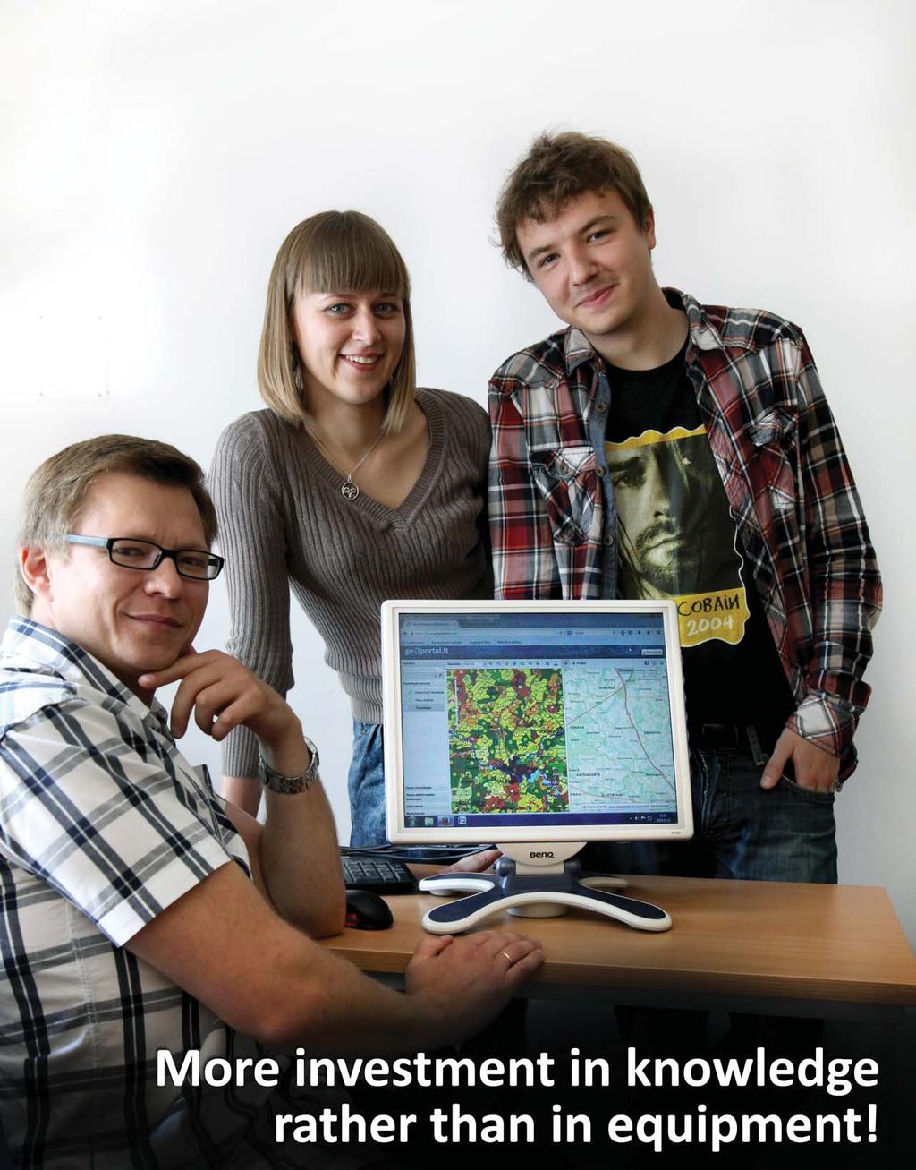
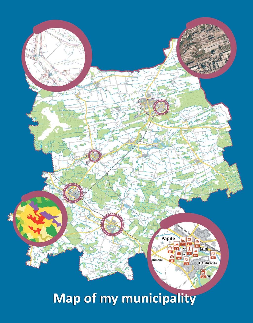
2 The Lithuanian Spa al Informa on Infrastructure is a system that connects organiza ons collec ng, distribu ng and using data related to the coordinates of the Earth s surface. This spa al or geographic data comprises almost all the data we use in our lives. It is processed using special geographic informa on systems (GIS). Spa al data collected by ins tu ons, businesses and educa onal organisa ons is complex, valuable and of great importance in addressing various ma ers. By developing the Lithuanian spa al informa on infrastructure, our government is ensuring that spa al data obtained from different sources is readily accessible and is as easy as possible to use. The Lithuanian spa al informa on portal (the LSI portal) is the most important component of the infrastructure it is a state informa on system for the online exchange of geographic informa on. By using the LSI portal you can access spa al data sets and their metadata (standardised informa on about data sets). The LSI portal spa al data services and web GIS solu ons have been made available free of charge to government ins tu ons and other providers of free public services. Due to the LSI portal services and tools, which are accessible to every user, geographical informa on use and transparency is increasing in the country, and be er reasoned decisions can be made in various fields. The LSI portal services are available at This factsheet introduces the LSI portal services and the project Lithuanian spa al informa on infrastructure development by implemen ng priority tools of the INSPIRE direc ve funded by EU structural support funds between 2012 and The project is being implemented under the implementa on measure Interoperability by Informa on Society For All, the economic growth programme (project No VP2-3.1-IVPK-06-V ). The partner of the project is the Na onal Land Service under the ministry of Agriculture and the State Enterprise Na onal Centre of Remote Sensing and Geoinforma cs GIS-Centras (SE GIS-Centras ). Project objec ves: To implement Direc ve 2007/2/EC of the Europe Parliament and of the Council of 14 March 2007 by establishing an Infrastructure for Spa al Informa on in the European Community (INSPIRE), and the requirements on interoperability of spa al data set out in the implemen ng documents of the Direc ve. To ensure provision of the best quality Lithuanian spa al data to Lithuanian and EU users that is adequate to the data themes referred to in Annex I and II (Geographical names, Administra ve units, Addresses, Cadastral parcels, Transport networks, Hydrography, Protected sites, Eleva on, Land cover, Orthoimagery). To expand the network of data providers and e-services, and increase the efficiency of na onal spa al data usage. The expected outcome of the project is that organisa ons geographical informa on collec on, maintenance and delivery costs will be reduced, ci zens access to sensi ve and detailed geographic informa on will be improved, and document coordina on processes will become simpler. The socioeconomic benefit to the country will be on average six million LTL per year from the implementa on of the project. Texts prepared by: Giedrė Beconytė, Rita Viliuvienė, Andrius Balčiūnas, Evelina Indilaitė Photos: Urtė Antanavičiūtė (11, 13, 15, 17, 23 p.), Vytas Markevičius (5, 22 p.), Sandra Uceda Queiros (22 p.) Graphic design: Giedrė Beconytė (7, 9, 15, 17, 22 p.), Julius Donatas Budrevičius (7, 15, 18 p.) SE GIS-Centras,


3 Geographic informa on services and solu ons Data and maps of the state Orthophoto maps, georeferen al data sets, mul -scale background maps, hybrid maps and much more is available free of charge to ci zens, organisa ons and all informa on systems that provide services for free. Diversity of spa al data and services Official public data sets that are provided to geoportal.lt using primary sources and regularly updated, aesthe cal professionally developed digital maps, sta s cal and scien fic maps, browsing and downloading services. Currently, the LSI portal provides more than 250 publicly available data sets. New services and GIS cloud New services are being developed and will help users to collect and maintain spa al data sets online and to share them with others, as well as allowing them to download and compile maps without needing any special so ware! Services to municipali es and other organisa ons The LSI portal services are successfully used by other informa on systems to carry out their func ons. Data collec on environments that can be embedded in any website have been developed for municipali es, tourist informa on centres and other organisa ons! 2

4 The LSI portal: services to everybody The LSI portal consists of two parts: content pages which can be opened directly from www. geoportal.lt, and the map browser ( lt/map). The portal pages contain methodical and training materials, documents, news, support texts and a dictionary of geographical terms. The thematic community areas have been designed for particular categories of geographical information users: cartographers, georeferential data users, and surveyors. The portal pages also provide access to spatial data sets, and offer the possibility to order and download them, review your order list, receive information on concluded contracts and data updates. In the My Portal area, users can check their account information, the rights granted, saved search settings, reports and other account-related information. Map browser is the environment used for work with maps and the most popular portal system. Here you cannot only view data, but also search for data sets and places on maps based on place names, use thematic catalogues of spatial data services where services are grouped according to their popular fields of application. The map browser has measurement, comparison, embedded map link creation, and various statistics calculation tools; you can compile, save and print your own maps in a format of your choice; you can also download these maps and spatial data. For your convenience, we are developing new tools which will enable easy use of data without any special software. The LSI portal e-services are various ways to use Lithuanian geographical information. The simplest are spatial data services: single actions performed on particular spatial data sets that are supplied by different data providers: To search data sets based on keywords and other criteria, to find and view their metadata To view spatial data using the map browser To order and download data sets or selected parts of them To order and download data sets or selected parts of them. These standard operations are also known as the LSI portal network services. Search and view functions are available to any user of geoportal.lt. If you want to order and download data, registration and agreement with the Terms of Use is required. Registration on the LSI portal and almost all spatial data services is free of charge! When ordering a service, verification of users identity may be requested, usually in cases when a user wants to download official data. Figure 1. Types of LSI portal services Interactive LSI portal services are more complex and comprise various operations using spatial data, for example, land reform land management project plans provision service. Such services have individual user interfaces. Did you know that...a map can convey more informa on in a single glance than pages of text. Humans have an innate ability to immediately no ce unknown rela ons and object loca on peculiari es in 2D or 3D space. This unique percep on feature has not been fully inves gated, but is successfully used in many fields. That is geographical insight, i.e. one of the means of acquiring new knowledge. Just try it! 3
5 4
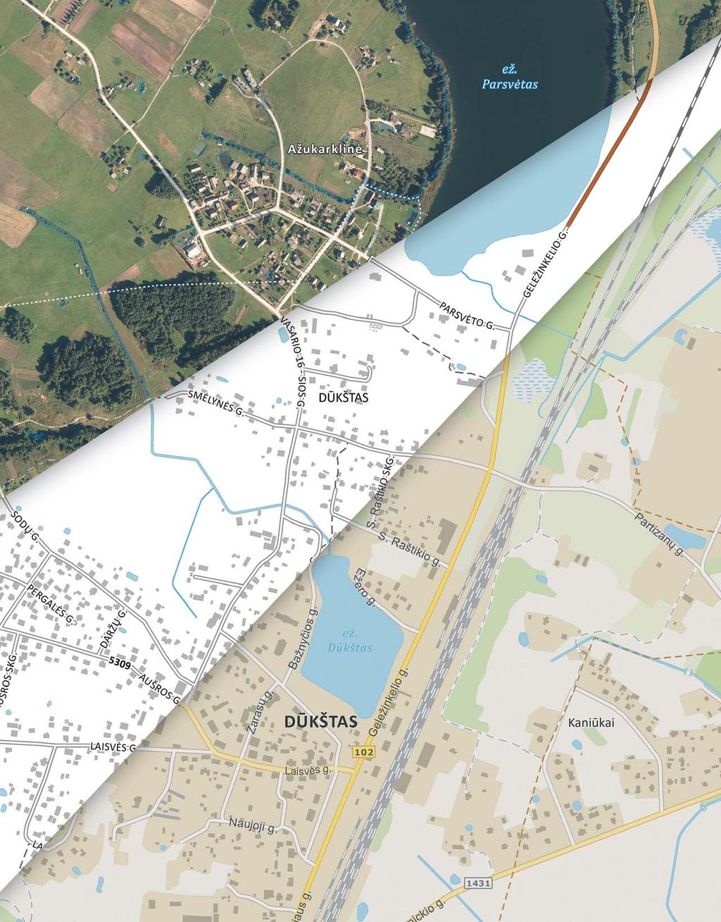
6 Most important state data and maps Official large-scale maps are some of the most important national documents. They display natural and anthropogenic features located within the country s territory: elevation points above the Earth s surface, bodies of water, forests, roads, buildings and communication networks. The spatial data used to develop this map is referred to as georeferential data. The most important sources of georeferential data are orthophoto maps, compiled using aerial photos which are taken on a regular basis for all or any territories and linked to geographic coordinates. The main orthophoto map of Lithuania ORT10LT is created based on accuracy requirements corresponding to a scale of at least 1: Orthophoto maps of densely built-up areas are of better resolution which complies to precision requirements at scale 1:5000 (ORT5LT) and 1:2000 (ORT2LT). These maps include easily identifiable small objects, including trees, small structures and cars. Orthophoto maps are used to compile georeferential data which can be displayed in different ways, as well as to split in different layers and to change individual objects. Georeferential data sets are supplied through the LSI portal free of charge by the National Land Service under the Ministry of Agriculture. They are updated by the SE GIS-Centras on a regular basis. You can order and download all data, or only the data that has been updated. The most recent data is at any time provided as a web map service (WMS). Georeferential base cadastre (GRPK) is an official set of relatively invariant simple geographical objects (axial lines, borders and points). It is updated on a regular basis using outdoor measurement data, and information received from other institutions and users about inconsistencies or changes observed. National georeferential data set GDR10LT at scale 1:10000 is updated monthly based on the updated GRPK data set. The GDR10LT data set consists of 12 spatial data themes: roads and streets; railways; buildings and constructions; land cover; geodetic points; trunk pipelines; electricity networks; air navigation barriers, forest quartal lines; natural and cultural heritage sites; administrative boundaries and place names. Georeferential data sets at other scales. Georeferential data sets at small scale GDR50LT (1:50000), GDR250LT (1:250000) and GDR1kLT (1: ) are used usually in cartography and developed by generalising information of GDR10LT. The information from large-scale georeferential data sets developed for residential areas for territory planning purposes (1:5000, 1:2000, 1:1000) is used to adjust GRPK, and GDR10LT data. At the LSI portal, we offer to users the background reference base map prepared by professional cartographers and adapted to use with 13 different scales. This map is updated on a regular basis using orthophoto map information. Linear elements and labels of the background map can be shown on the orthophoto map; this kind of map is called a hybrid background map. Background maps in the map browser can be partially transparent, and so they can easily be used with other data sets. The map can be printed in a format of your choice at a higher than screen resolution. We guarantee the quality of background maps and that they are continuously being improved. Did you know that... the me required by an experienced cartographer to compile a georeferen al data-based map that is quickly transmi ed on the Internet, beau ful and cartographically correct, is approximately 500 hours. 5
7 6

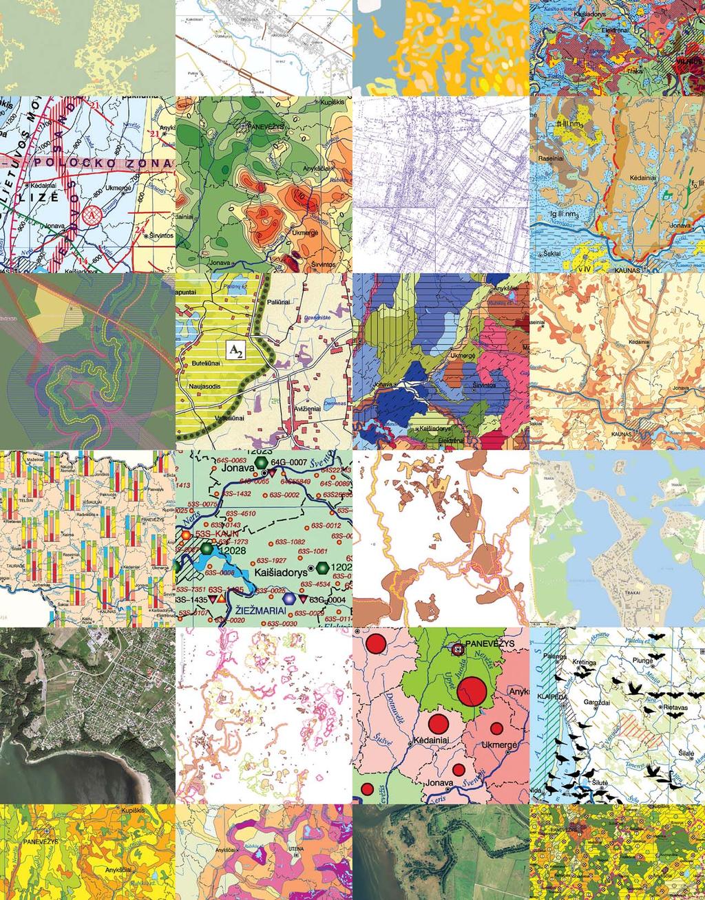
8 Diversity of spa al data The LSI portal does not only provide georeferential data. Thematic data sets are provided by institutions that implement national policy in different fields, municipal institutions, educational and training institutions, public organisations, and business entities. In spring 2014, 28 organisations provided 255 spatial data sets through the LSI portal. We are striving to facilitate access through the portal to all official national and municipal data sets and more information collected by competent organisations. The volume of large-scale data that is provided by the municipalities keeps increasing. A data set can be collected without special GIS software. For example, specialists of Lithuanian tourist information centres simply enter data on places of interest to sightseers in the portal s map browser. This is the way how data sets are collectively developed by different bodies. Spatial data service is the LSI portal service that helps to find, view or download particular data sets. Using the map browser, registered users can choose public or orderable services from a thematic catalogue where view services are grouped by popular areas of use: georeferential data; data for surveyors and land use planners; municipal data; data from the national atlas of Lithuania etc. Metadata is brief, standardised, essential information about each data set or service. Metadata is provided to all users free of charge. This information is necessary to evaluate whether data sets have been obtained from reliable sources and are suitable for their intended use; it is possible to obtain the date when the data set was created or updated, the terms of use, to obtain contact data of administrator and distributor. The coverage of data set in map and a map fragment is also shown in document of metadata. The main LSI portal data providers are government institutions: National Land Service that provides a biggest number of data sets, Figure 2. Search and metadata document in the LSI portal including national georeferential data and the most important data on land; the Lithuanian Geological Survey, the State Service for Protected Areas, the State Forest Survey Service, the Lithuanian Department of Statistics, the State Enterprise Centre of Registers, the Department of Cultural Heritage, the municipal administrations and other organisations. Large-scale data on engineering communications and small-scale maps of the National atlas of Lithuania covering various themes, georeferential data which is updated monthly and historical cartographic material, precise facts and statistical summaries on maps are available on the LSI portal. The diversity of the data accessible on the portal is constantly increasing, allowing users to perform a comprehensive analysis of the territory of Lithuania. We invite municipal administrations, education and training organizations to share the valuable data that they have already collected. During 2013 users of geoportal.lt received almost a million e-services. Did you know that...a map that displays in detail both geographic objects and geographic objects or phenomena related to a theme selected by the author is referred to as a thema c map. The LSI portal contains up to 200 different thema c data sets and maps of Lithuania: from informa on about pollu on sources to geoecological tension of landscapes. 7
9 8
10 Interac ve services The LSI portal offers more than just spatial data services. Specialists from SE GIS-Centras have created many complex Web GIS solutions for people and organisations. These are interactive e-services with individual map browser environments and tools which are tailored for specific challenges. They are constantly improved and adapted to the needs of users! Historical cartographic material The LSI portal component that has been designed to create, maintain and use a cartographic heritage archive is tailored for two interactive services that assure provision of geodetic and cartographic materials fund (GKMF) and land reform land management project plans. The geodetic and cartographic materials fund consists of topographic map sheets from different years. The maps are provided in digital format, linked to coordinates and described by metadata. The GKMF is regularly expanded to systematically collect and manage all national geodetic and cartographic material. Today users have access to almost 8,000 sheets of previously published maps. The GKMF material is used to carry out national geodetic and mapping works. It provides an invaluable basis for historical analysis of the evolution of particular territories. More information on GKMF is available at the thematic channel ( The system of land reform land management project plans is operated in a very similar way, but has a simpler user environment. Today users can view and download 9,500 land reform project plans. There is a plan to collect other types of geodetic, cartographic and other graphic material related to land management. You can use cartographic materials at geoportal.lt: perform document search based on specified criteria (document coordinate system, creation date, scale, map extent, the document type and preferred file format). You can view or download the found maps to your computer in a graphic format of your choice (SID, TIF or PDF). LSI portal services for land accoun ng and maintenance After the tax on desolated land was raised in 2013, we have developed e-service which allows people, who have noticed inaccuracies on map of desolated land, or know that the situation in the territory has changed, to mark the error on a map and to communicate it through the Internet. In the last year we have registered more than 7,500 notices about inaccuracies. Information is automatically transferred to the State Enterprise the State Land Fund, the administrator of data relating to desolated land. The service is accessible on The map is easy to use. Using the system for desolated land registration errors, you can view data about desolated land on the vector or orthophoto map background on geoportal.lt, and find desolated land using different criteria. The e-service of the Vacant State Land Fund ( allows specialists of land management and others to work with information about vacant state property in rural areas: to collect, find and analyse data based on different criteria, e.g., what kinds of property and in what proportion the vacant state land fund is formed from. Did you know that...the cartographic material fund can be developed directly online. Cartographic heritage administrator can upload the map document to the LSI portal, link it to coordinates and publish using only an Internet browser and the simple LSI portal tool designed for that purpose. It takes only a few minutes! 9

11 10

12 Our users On geoportal.lt users cooperate, share their experiences, and create added value to spatial data. Non-registered users receive the general portal s services just by visiting its pages. They can use any portal information that is available to public: training and information material; search and metadata systems; background maps in the map browser; Land information system and Cartographic material funds services; measurement, map export, and map link tools. The portal information for non-commercial purposes can be used virtually without limits, although if this information is published in other places, identification of the source is required. Please read the portal s terms of use and copyright information, which you will find on the main page of the portal. Additionally, registered users can use all public spatial data services directly in the map browser, order spatial data sets and conclude use contracts in case when use is limited. They can save settings of performed searches, compile maps, enter their spatial data directly into the portal, and mark errors in data sets. The assigned rights and user profile information is also visible to registered users. Registration is required to provide metadata and data sets to the LSI portal, to receive special services and to obtain the right to enter information. Registration is free of charge to all users. The LSI portal data providers are portal users who share the data that they maintain, receive reports about data usage, and sell pay data on the portal. Data providers automatically receive data errors that have been registered by users. The data provider agrees with the LSI portal administrator regarding terms and conditions for the provision of data and signs a data provision contract which obliges both parties to ensure the highest possible level of data accessibility. The LSI portal is designed for everybody. Of course, it was primarily intended to increase the efficiency of spatial data use in institutions and business entities. Five years later, it is safe to say that this goal has been achieved. Up to 30% of the portal users are institutional staff who manage their work faster and solve problems better, because so much information about territories is now available at a single click. The LSI portal services save hundreds of hours of civil servants working time each year. Figure 3 user structure and dynamics Almost half of the LSI portal users are from the business sector: mostly geodesists, surveyors, planners and other GIS specialists. We are inviting more business representatives who are able to create added value geographic information products and distribute them through the LSI portal. Users from education and training institutions create new information and knowledge from incoming data that they can spread further. Students are highly active users of the LSI portal, since they are of a generation which is well aware of the importance of open information. They use the data and study material which has been published in the portal in Lithuanian and English. Did you know that...non-expert users movement, which started in the 21st century, and uses geographic informa on technologies, tools and methods to create spa al data sets, already has a name neogeography. 11

13 12
14 Development of the LSI portal: Implementa on of the INSPIRE direc ve Directive 2007/2/EC of the European Parliament and of the Council of 14 March 2007 (OL 2007 L 108, p. 1) establishing an Infrastructure for Spatial Information in Europe entered into force on 15 May The aim of the Directive is to enable Member States to use mutually compatible spatial data about the environment obtained from primary sources. Common Implementing Rules of the Directive are adopted and Member States should ensure that the spatial data infrastructures are compatible to these rules. The Directive will be implemented in stages until Further information on the INSPIRE directive is available at The INSPIRE directive is an incentive for Lithuanian organisations, particularly state institutions, to properly organise, standardise and provide collected spatial data in the best possible way, not only to European Union institutions, but, first of all, to Lithuanian users. One or a few spatial data sets must be consistent to the themes indicated in the Annexes to the INSPIRE directive: the themes in Annexes I and II, which are essential for management: (geographical names, administrative units, addresses, cadastral parcels, transport networks, hydrography, protected sites, elevation, land cover, orthoimagery, and geology) and the broad range of themes covered in Annex III, including natural, social and economic aspects. The list of spatial data sets, which fall under these themes is revised and updated every year according to a resolution of the Lithuanian government, requiring these data administrators to provide data through the LSI portal. The LSI portal is a technological platform that is used to implement INSPIRE requirements in Lithuania. The search, view, download and transformation services that fulfil interoperability requirements laid down in the Implementation Rules will be provided, and performance, capacity and availability of all spatial data services will increase after the completion of the project that is carried out from 2012 to At the LSI portal, we offer tools to all data providers, helping them to provide their data on the LSI portal in accordance with the INSPIRE directive s requirements, and we help them to transform data sets in a manner that is compatible with the INSPIRE data specifications. We provide consultations and methodical assistance to all data providers. How to identify which data sets should be submitted to INSPIRE? Data sets from primary sources that best correspond to the themes set out in INSPIRE are selected. At least one or more data sets should correspond to one theme. Is it necessary to submit a data set indicated in the government resolution if it does not meet the requirements of INSPIRE data specifi cations? Yes. Data sets that have not been recently created or transformed may not comply with appropriate INSPIRE data specifications. It is more important that data is described using metadata and is available online. The INSPIRE directive implementation in Lithuania is described at the LSI portal s thematic channel INSPIRE. Here you can find information about the provision of spatial data sets and their metadata, and the values of monitoring indicators. Did you know that...lithuania is one of the few European countries where development of spa al informa on infrastructure began long before the INSPIRE direc ve was adopted. The LSI portal has been developed to be a complex knowledge system of geographic informa on which provides different services to users: from data searches to GIS training material. In Europe, there are only a few portals of this kind. 13

15 14
16 LSI portal development: the GIS cloud and other new services Online management of spa al data We will introduce a new e-service based on cloud computing technology later in Users of the service entitled Online Management of Spatial Data will be able to maintain their spatial data and maps on the LSI portal. This will not require any additional GIS software. Users will use cloud computing based system to enter, revise and publish new spatial data or to integrate existing date, as well as to create public or user-specific maps. The mobile service will allow them not only to view data sets and maps, but also to edit and fill them in using GPS equipment. In this way, they can mark territory problems or planned works, show land boundaries and collect data on community-related objects and incidents. The possibility to collect spatial data online is very important to those who are inexperienced geographic information users: scientists, SME specialists, employees of public institutions and members of community organisations. Each new set of high quality spatial data which we share with others on the LSI portal is another step towards a better understanding of the natural, social and information environment. Verifica on of measurement data conformity to GRPK data Surveyors using this service on the LSI portal will be able to upload available measurement data and use appropriate tools to identify whether this data corresponds with data from the georeferential base cadastre dataset (GRPK) of e.g. roads, streets, railways, rivers, and rivulets, axial lines of drainage ditches, boundaries of lakes and ponds. Users will also be able to receive conclusions regarding conformity of their data online, thus saving both the surveyor s and client s time. Provision of consent to construct transport communica ons, networks and buildings on state-owned land The public e-service is available to users who seek to obtain permission to construct transport communications, or engineering communications and necessary supporting structures on stateowned land that is not divided into separate parcels. Applicants will not have to go to a local land planning department and waste their time waiting in a queue; the new service will allow them to submit applications on the LSI portal. There they will be able to create and submit a new drawing. An application will be automatically registered and sent to the local land planning department for evaluation. Applicants will be able to see their application s submission and evaluation state and will be notified when the decision is made. This helps to save time for both applicants and local land planning department specialists. Analysis and evalua on of land fund The e-service used to perform analysis and evaluation of land funds will allow people to use data from the LSI portal to evaluate the characteristics of their selected territory. Each user will be able to indicate land boundaries (by uploading data or by drawing shapes directly in the map browser); to choose indicators and spatial data sets; to perform analyses; and to receive statistical reports illustrated by charts. When planning, for example, to rent a parcel of land, a summary of information will be provided, including details of land use, dominant soils, land productivity, restrictions stipulated in the special terms of land use and desolated land. Did you know that...each user of geoportal.lt can mark several objects on a map, enter their names and a brief descrip on, then form and add an interac ve map to their website. Use the LSI portal link to a mapping service! 15
17 16
18 The LSI portal for municipali es About one sixth of users of the LSI portal are employees of municipal institutions and enterprises. Administrations of Lithuanian municipalities collect a lot of precise and valuable information about sites in their territory, including engineering communications, drainage systems, green plantations, containers for secondary raw material, outdoor advertising, as well as other sites and their locations. People use this information every day; it is shared between specialists of municipalities, businesses. Municipalities use the LSI portal services because the tools for geographical information processing which are available online are provided free of charge and without any conditions. Municipality map All the municipalities in the country can use online maps on the LSI portal. The maps are compiled by the SE GIS-Centras. The interactive map displays spatial data provided on the LSI portal. The map is adapted for the particular needs of each municipality: to display selected data sets, create additional tools that are used to work with these data, and symbols. It is possible to search for place names and routes, to prepare and print a map with settings of the user s choice, and download collected data in a desirable format. Even those municipalities that already have online maps can always supplement them by using the LSI portal s professional mapping solutions and other new tools which are constantly developed. The online map of municipality is interactive and easy to use, free of charge to all users; it can be used at any time and is accessible from any place with Internet access. The map is easy to add to Internet pages and always includes the most recent data. Integra on of municipal Municipal topographic plans and digital spatial data sets are included in the list of themes that were approved by a resolution of the Government of the Republic of Lithuania and which data shall be provided through the LSI portal for the INSPIRE directive. Detailed geographic information about communication infrastructure (power transmission, telecommunication networks; water pipelines; oil, gas, heat and wastewater pipelines; and transport infrastructure) is of particular importance. This data is used by municipal administrations, as well as by businesses that conduct geodetic measurements, territory planning and construction design, operate utility networks. It is also used by real estate and construction companies; investors; and land owners and buyers. It is therefore our goal to make all collected information about communication networks available in one place and to effectively provide it online. Municipal spatial data sets can be combined into a single state-wide and singletechnology-based spatial data system. The LSI portal already has all the means to attain this aim. It s up to municipalities to decide which data sets they want to provide, although their decision does not alter their ability to use the LSI portal services designated for them. Municipal thema c channel Separate thematic channel of geoportal.lt is intended for the use of municipalities. There the user can check the list of spatial data sets provided by each municipality, find their metadata and maps. Relevant methodical materials and detailed instructions about how to provide data through the LSI portal are also provided. Did you know that...the largest number (17) of data sets on the LSI portal is provided by Tauragė District Municipality Administra on. Par cularly precise and complete data is provided by Vilnius City Municipality Administra on. 17
19 18
20 The LSI portal for other informa on systems The LSI portal is an open system that is designed for a whole country rather than for a particular organisation. Most of the e-services and technological solutions available on geoportal.lt are successfully used by other organisations that want to save time and money. The LSI portal s spatial data services are easy to integrate into other information systems and use in other applications. The most popular service in the LSI portal is the multi-scale background map which is used for internal purposes of organisations, and is displayed as background in other systems. Several variants of the main background map are supported and can be tailored to client needs. This is the only digital map that is constantly updated from official data. We provide this continuously improved map and adapted spatial data services free of charge to other organisations and their information systems to use for both non-commercial and for commercial purposes. All you need to do is apply to SE GIS- Centras and sign a bilateral e-service provision contract. Everything about the land... We seek to provide on the LSI portal not only the data that is handled by different institutions: parcels of land, areas where parcels are not formed, desolated land, restrictions of land use, drainage systems, types of soil, etc., but also as many public and administrative services related to land as possible. Therefore, we create standardised components that are available to different e-service providers: spatial data review and comparison, editing and analysis, criteriabased search, statistics calculation and online data upload. The land information system services are provided exclusively through the LSI portal map browser ( SE GIS-Centras and SE State Land Fund share resources and expertise to successfully develop together new geographic information technology solutions and tools which have been made available to all LSI portal users. Map browser a version for you? Many companies and institutions have important spatial data but use it only for simple operations: enter, edit and publish online. To date, a substantial amount of money has been spent on various semiprofessional GIS solutions whose outcomes are online maps of poor quality, indifferent users, and systems that are difficult to develop and support. We offer simple and effective means based on modern LSI portal technology. Adapted map browser solutions are successfully used by tourist information centres in Lithuanian cities and regions (tourism map of Lithuania), the Lithuanian Consumer Institute (interactive map of organic farms) and other organisations to save money on software, data storage and system support, and provide users with more valuable information. Did you know that...crowdsourcing is the process of data collec on for online maps jointly performed by users in different loca ons. Crowdsourcing can be professional or amateur, voluntary or for a charge, but is always coordinated. This is a way to quickly compile spa al data sets. 19
21 20

: the georeferential and orthophoto background maps and search service.")


22 Others about us Jana Vanagė, GIS specialist at Lithuanian Department of Sta s cs Geoportal.lt ensures that you do not get lost in the variety of spatial data. There is no longer any need to waste time searching what data sets from institutions are available, and what the conditions of acquirement are. All we need to do is visit geoportal.lt, look for the required data, then to download it, use and receive updates all using the same site. Lithuanian Department of Statistics provides statistical information through geoportal.lt. I believe it is a great tool to disseminate information and advertise our organisation. We also use geoportal.lt services in the Official Statistics Portal of the Lithuanian Department of Statistics (osp.stat.gov.lt): the georeferential and orthophoto background maps and search service. In this way our institution can be sure that the reference base data of Lithuania data is always up to date and relevant to the current situation. The search service allows us to find places or sites in Lithuania for which statistical information is being analysed. Darius Ka lius, director of UAB GEOMANAI Geoportal.lt is an excellent information platform which contains compiled, processed and structured archives that have been practically inaccessible to users for many years. Using an interactive online environment allows us to finish work faster and to improve its quality. We welcome the opportunity to obtain necessary information from a single portal quickly and for free. Many thanks to all the staff of the geoportal.lt for a great step forward and I encourage them to continue successful development. Ramūnas Mockevičius, head of the State Enterprise the State Land Fund The State Enterprise the State Land Fund is the administrator of the Land Information System (LIS). We use the technical and software solutions of geoportal.lt for the provision of the LIS data sets and related services. The Land Information System includes up to date data sets that describe land use, resources, productivity, natural and economic characteristics, drainage state, and are prepared in accordance with the geographic information system principles; it also includes management tools that, when used with the georeference base data, allow this information to be processed and data to be provided to users on the Web. We publish the LIS data sets and management tools in geoportal.lt to focus on LIS development, support and improvement, while technical issues (data backups, system security, accessibility issues, etc.) are successfully managed by specialists of the SE GIS-Centras. Dr. Habil. Algimantas Česnulevičius, President of Lithuanian Cartographic Society, professor of Vilnius University The Lithuanian spatial information portal is a reliable, user-friendly and constantly developing environment. Cartographers and scientists, as well as producers use a broad range of spatial data. It is readily available in a single place; moreover, the sources are well-known and reliable, and, if data is updated, we receive information immediately. We are happy to see that most of the data which is needed for scientific research is easily and freely available, and the digital maps developed by the SE GIS- Centras are of excellent cartographic quality. We welcome the initiative of the National Land Service to publish maps of the national atlas of Lithuania on the LSI portal, and encourage cooperation between institutions and scientists. Geoportal.lt is an important part of the emerging knowledge society in Lithuania. 21

23 Geoportal.lt team We constantly improve the Lithuanian spa al informa on portal and provide more and more e-services and spa al data. It is important for us to make our services easy to use, allowing you to find easily the data that you want and to make it comfortable to work with. We have prepared a broad range of informa on to help with using the LSI portal. Video tutorials are a fast way to learn how to perform desired ac ons. Users have viewed video lessons on our Youtube channel more than 11,000 mes. We also publish presenta ons about Geoportal.lt on Slideshare. Useful informa on about the LSI portal is available in both Lithuanian and English. Interes ng facts and news about the LSI portal can be found on Facebook. We communicate informally with users on the Geoportal.lt Facebook page. It is great to see that our informal community of interest keeps growing. We are open to ideas and sugges ons concerning improvement of the LSI portal. We will do our best to implement them so that geoportal.lt remains the best place to share spa al informa on about Lithuania. 22

24 facebook youtube slideshare 23
NATIONAL BENEFITS OF INSPIRE IMPLEMENTATION THE REAL LIFE USE CASES
 NATIONAL BENEFITS OF INSPIRE IMPLEMENTATION THE REAL LIFE USE CASES Andrius Balciunas, SE GIS Centras, a.balciunas@gis centras.lt Evaldas Rozanskas, SE GIS Centras, e.rozanskas@gis centras.lt INSPIRE conference
Project based approach developing National Spatial Data Infrastructure in Lithuania
 Project based approach developing National Spatial Data Infrastructure in Lithuania National Land Service under the Ministry of Agriculture of The Republic of Lithuania Cadastres & Geodesy Department Director
SDI Development in Georgia. Mari Khardziani Head of International Relations Unit National Agency of Public Registry
 SDI Development in Georgia Mari Khardziani Head of International Relations Unit National Agency of Public Registry Kehl, Germany September 5, 2017 2 National Agency of Public Registry Legal Entity of Public
The improvement of production of the GDR50LT in Lithuania
 The improvement of production of the in Lithuania Kęstutis PAPŠYS, Lina PAPŠIENĖ, Julius D. BUDREVIČIUS, Marius MARMA, Evaldas ROŽANSKAS, Mindaugas PAŽEMYS / GIS-Centras Jurgita ŠPŪRAITĖ / National Land
SWEDISH SDI DEVELOPMENT & IMPLEMENTATION OF INSPIRE
 SWEDISH SDI DEVELOPMENT & IMPLEMENTATION OF INSPIRE Christina Wasström, Lantmäteriet, 801 82 Gävle, Sweden, christina.wasstrom@lm.se ABSTRACT The Swedish Government and Parliament has given Lantmäteriet
Global Geospatial Information Management Country Report Finland. Submitted by Director General Jarmo Ratia, National Land Survey
 Global Geospatial Information Management Country Report Finland Submitted by Director General Jarmo Ratia, National Land Survey Global Geospatial Information Management Country Report Finland Background
GIS Building Communities beyond National Borders (Building Successful Spatial Data Infrastructures) Nick Land, ESRI Europe
 Nick Land, ESRI Europe") GIS Building Communities beyond National Borders (Building Successful Spatial Data Infrastructures) Nick Land, ESRI Europe UK worst flooding in the last 60 years 350,000 households without drinking water
GIS Building Communities beyond National Borders (Building Successful Spatial Data Infrastructures) Nick Land, ESRI Europe UK worst flooding in the last 60 years 350,000 households without drinking water
GIS FOR MAZOWSZE REGION - GENERAL OUTLINE
 GIS FOR MAZOWSZE REGION - GENERAL OUTLINE S. Bialousz 1), K Mączewski 2), E. Janczar 2), K. Osinska-Skotak 1) 1) Warsaw University of Technology, Warsaw, Poland 2) Office of the Surveyor of the Mazowieckie
Land Use in the context of sustainable, smart and inclusive growth
 Land Use in the context of sustainable, smart and inclusive growth François Salgé Ministry of sustainable development France facilitator EUROGI vice president AFIGéO board member 1 Introduction e-content+
Land Board, NW Services and SDI Tambet Tiits, FRICS
 Land Board, NW Services and SDI Tambet Tiits, FRICS 07.09.2016 200th anniversary of the Struve Geodetic Arc Friedrich Georg Wilhelm Struve and Carl Friedrich Tenner Struve Geodetic Arc The Struve Geodetic
Proposal for a DIRECTIVE OF THE EUROPEAN PARLIAMENT AND OF THE COUNCIL. establishing an infrastructure for spatial information in the Community
 Proposal for a DIRECTIVE OF THE EUROPEAN PARLIAMENT AND OF THE COUNCIL establishing an infrastructure for spatial information in the Community INSPIRE http://inspire.jrc.it/ Alessandro Annoni 1 EU Commission
UNITED NATIONS E/CONF.96/CRP. 5
 UNITED NATIONS E/CONF.96/CRP. 5 ECONOMIC AND SOCIAL COUNCIL Eighth United Nations Regional Cartographic Conference for the Americas New York, 27 June -1 July 2005 Item 5 of the provisional agenda* COUNTRY
Automatic Generalization of Cartographic Data for Multi-scale Maps Representations
 Environmental Engineering 10th International Conference eissn 2029-7092 / eisbn 978-609-476-044-0 Vilnius Gediminas Technical University Lithuania, 27 28 April 2017 Article ID: enviro.2017.169 http://enviro.vgtu.lt
The Swedish National Geodata Strategy and the Geodata Project
 The Swedish National Geodata Strategy and the Geodata Project Ewa Rannestig, Head of NSDI Co-ordination Unit, Lantmäteriet, ewa.rannstig@lm.se Ulf Sandgren, Project Manager Geodata Project, Lantmäteriet,
SITMUN: Cooperating to Build Local SDIs in the Barcelona Region
 SITMUN: Cooperating to Build Local SDIs in the Barcelona Region Diputació de Barcelona Territory and Sustainability Area Territorial Information Systems Department INSPIRE CONFERENCE Barcelona, September
The National Spatial Strategy
 Purpose of this Consultation Paper This paper seeks the views of a wide range of bodies, interests and members of the public on the issues which the National Spatial Strategy should address. These views
Adding value to Copernicus services with member states reference data
 www.eurogeographics.org Adding value to Copernicus services with member states reference data Neil Sutherland neil.sutherland@os.uk GIS in the EU 10 November 2016 Copyright 2016 EuroGeographics 61 member
UTAH S STATEWIDE GEOGRAPHIC INFORMATION DATABASE
 UTAH S STATEWIDE GEOGRAPHIC INFORMATION DATABASE Data Information and Knowledge Management NASCIO Awards 2009 STATE GEOGRAPHIC INFORMATION DATABASE B. EXECUTIVE SUMMARY Utah has developed one of the most
Demonstration of a local SDI solution with several stakeholders in pilot areas in line with EU best practices
 EU Twinning project for the Agency of Land Relations and Cadaster (ALRC)- Organization, Streamlining and Computerization Process in Mapping in the Republic of Moldova. Demonstration of a local SDI solution
Status of implementation of the INSPIRE Directive 2016 Country Fiches. COUNTRY FICHE Croatia
 Status of implementation of the INSPIRE Directive 2016 Country Fiches COUNTRY FICHE Croatia Introduction... 1 1. State of Play... 2 1.1 Coordination... 2 1.2 Functioning and coordination of the infrastructure...
GIS Geographical Information Systems. GIS Management
 GIS Geographical Information Systems GIS Management Difficulties on establishing a GIS Funding GIS Determining Project Standards Data Gathering Map Development Recruiting GIS Professionals Educating Staff
UNOFFICIAL TRANSLATION
 UNOFFICIAL TRANSLATION THE CROATIAN PARLIAMENT 1135 Pursuant to Article 89 of the Constitution of the Republic of Croatia, I hereby issue the DECISION PROMULGATING THE NATIONAL SPATIAL DATA INFRASTRUCTURE
TERMS OF REFERENCE FOR PROVIDING THE CONSULTANCY SERVICES OF
 1 Cartographic Database and TM100 Product Specifications TERMS OF REFERENCE FOR PROVIDING THE CONSULTANCY SERVICES OF Production and establishment of cartographic database for scale 1:100,000 and production
a national geological survey perspective François ROBIDA BRGM (French Geological Survey)
") a national geological survey perspective François ROBIDA BRGM (French Geological Survey) Pre-Conference Seminar on Socio-Economic Value of Geospatial for National and Regional Development 21 August 2017,
a national geological survey perspective François ROBIDA BRGM (French Geological Survey) Pre-Conference Seminar on Socio-Economic Value of Geospatial for National and Regional Development 21 August 2017,
INSPIRE Monitoring and Reporting Implementing Rule Draft v2.1
 INSPIRE Infrastructure for Spatial Information in Europe INSPIRE Monitoring and Reporting Implementing Rule Draft v2.1 Title INSPIRE Monitoring and Reporting Implementing Rule v2.1 Creator DT Monitoring
INSPIRE and Land Use Planning System in Portugal
 INSPIRE and Land Use Planning System in Portugal Rui Amaro Alves Director General Directorate General for Territorial Development ruialves@dgterritorio.pt Carlos Simões Senior Technician Directorate General
ArcGIS for Desktop. ArcGIS for Desktop is the primary authoring tool for the ArcGIS platform.
 ArcGIS for Desktop ArcGIS for Desktop ArcGIS for Desktop is the primary authoring tool for the ArcGIS platform. Beyond showing your data as points on a map, ArcGIS for Desktop gives you the power to manage
Large Scale Mapping Policy for the Province of Nova Scotia
 Large Scale Mapping Policy for the Province of Nova Scotia December, 2005 Version 1.0 TABLE OF CONTENTS PAGE BACKGROUND...3 POLICY...5 Policy 1.0 Large Scale Mapping Program...5 Policy 2.0 Service Offering...5
National Cartographic Center
 National Cartographic Center NCC activities and accomplishments Activities of national organizations, institutions and universities in field of geomatics Large scale maps Medium scale maps Small scale
THE CADASTRAL INFORMATION SYSTEM IN THE REPUBLIC OP SOUTH AFRICA
 I $:? Distr.: LIMITED ECA/NRD/CART.9/ORG.27 November 1996 Original: ENGLISH Ninth United Nations Regional Cartographic Conference for Africa Addis Ababa, Ethiopia 11-15 November 1996 THE CADASTRAL INFORMATION
Compact guides GISCO. Geographic information system of the Commission
 Compact guides GISCO Geographic information system of the Commission What is GISCO? GISCO, the Geographic Information System of the COmmission, is a permanent service of Eurostat that fulfils the requirements
Economic and Social Council 2 July 2015
 ADVANCE UNEDITED VERSION UNITED NATIONS E/C.20/2015/11/Add.1 Economic and Social Council 2 July 2015 Committee of Experts on Global Geospatial Information Management Fifth session New York, 5-7 August
GEOMATICS. Shaping our world. A company of
 GEOMATICS Shaping our world A company of OUR EXPERTISE Geomatics Geomatics plays a mayor role in hydropower, land and water resources, urban development, transport & mobility, renewable energy, and infrastructure
INSPIRE Directive. Status June 2007
 INSPIRE Directive INfrastructure for SPatial InfoRmation in Europe Status June 2007 European Commission Directorate-General Environment Research, Science and Innovation Unit Rue de la Loi, 200 1049 Brussels
Establishing the National Spatial Data Infrastructure (NSDI) for Norway a joint effort by many stakeholders SPATIAL DATA FOR BENEFIT OF THE SOCIETY
 for Norway a joint effort by many stakeholders SPATIAL DATA FOR BENEFIT OF THE SOCIETY") Establishing the National Spatial Data Infrastructure (NSDI) for Norway a joint effort by many stakeholders SPATIAL DATA FOR THE BENEFIT OF SOCIETY OUTLINE Political background Norway digital - The Norwegian
Establishing the National Spatial Data Infrastructure (NSDI) for Norway a joint effort by many stakeholders SPATIAL DATA FOR THE BENEFIT OF SOCIETY OUTLINE Political background Norway digital - The Norwegian
STATE GEOGRAPHIC INFORMATION DATABASE
 STATE GEOGRAPHIC INFORMATION DATABASE Data Information and Knowledge Management STATE GEOGRAPHIC INFORMATION DATABASE EXECUTIVE SUMMARY Utah has developed one of the most comprehensive statewide GIS resources
 Boone County GIS has the right to inquire about and investigate the use of any requested products and deny access to anyone based on concerns relating to privacy, security, public health, public safety,
Ministry of ICT of I.R.IRAN
 The ECO 8/6 mill km 2 10 Slamic countries ~330 mill people Oil, Gas, Industries,Tourism 2 Issue transformation in last decade Problem solving needs more integrated approach More interaction &complexity
Study Visit University of Applied Sciences Utrecht Netherlands
 Study Visit University of Applied Sciences Utrecht Netherlands Directorate-General for Territorial Development Lisbon 1 April 2014 1 Agenda Presentation Cadastre Department Surveying / Geodesy Department
INSPIRE - A Legal framework for environmental and land administration data in Europe
 INSPIRE - A Legal framework for environmental and land administration data in Europe Dr. Markus Seifert Bavarian Administration for Surveying and Cadastre Head of the SDI Office Bavaria Delegate of Germany
REPORT ON INVESTMENTS
 REPORT ON INVESTMENTS D.T2.3.3 Investments for technical equipment for the implementation of Web-GIS platform in Mantova 1 Local support group designing Mantova Web-GIS platform. Picture by Maria Giulia
ACRONYMS AREAS COUNTRIES MARINE TERMS
 Natura 2000 ACRONYMS AREAS COUNTRIES MARINE TERMS DEFINITION A European network of protected sites under the European Habitats and Birds Directives, aiming to protect the most valuable and threatened European
Sustainable and Harmonised Development for Smart Cities The Role of Geospatial Reference Data. Peter Creuzer
 Sustainable and Harmonised Development for Smart Cities The Role of Geospatial Reference Data Peter Creuzer 1. Introduction - Smart Cities and Geodata 2. Geodata in Germany 3. Examples 4. Data and Service
CentropeSTATISTICS Working Interactively with Cross-Border Statistic Data Clemens Beyer, Walter Pozarek, Manfred Schrenk
 Clemens Beyer, Walter Pozarek, Manfred Schrenk (Dipl.-Ing. Clemens Beyer, CEIT ALANOVA, Concorde Business Park 2/F, 2320 Schwechat, Austria, c.beyer@ceit.at) (Dipl.-Ing. Walter Pozarek, PGO Planungsgemeinschaft
SDI Development in the Russian Federation
 , the Russian Federation Key words: SDI development, the Russian Federation SUMMARY A reform in the field of spatial data is gathering headway in Russia. Creation of a single agency, which united state
INSPIRE implementation in the Turkish Ministry of Environment and Urbanization Producing and Publishing Environmental Data
 INSPIRE implementation in the Turkish Ministry of Environment and Urbanization Producing and Publishing Environmental Data Ezgi Sarmusak Urban Planner, MoEU Sibel Süer Toybıyık - Assistant Expert, MoEU
Write a report (6-7 pages, double space) on some examples of Internet Applications. You can choose only ONE of the following application areas:
 on some examples of Internet Applications. You can choose only ONE of the following application areas:") UPR 6905 Internet GIS Homework 1 Yong Hong Guo September 9, 2008 Write a report (6-7 pages, double space) on some examples of Internet Applications. You can choose only ONE of the following application
UPR 6905 Internet GIS Homework 1 Yong Hong Guo September 9, 2008 Write a report (6-7 pages, double space) on some examples of Internet Applications. You can choose only ONE of the following application
Status of implementation of the INSPIRE Directive 2016 Country Fiches. COUNTRY FICHE Finland
 Status of implementation of the INSPIRE Directive 2016 Country Fiches COUNTRY FICHE Finland Introduction... 1 1. State of Play... 2 1.1 Coordination... 2 1.2 Functioning and coordination of the infrastructure...
Economic and Social Council
 United Nations Economic and Social Council Distr.: General 2 July 2012 E/C.20/2012/10/Add.1 Original: English Committee of Experts on Global Geospatial Information Management Second session New York, 13-15
Internal Audit Report
 Internal Audit Report Right of Way Mapping TxDOT Internal Audit Division Objective To determine the efficiency and effectiveness of district mapping procedures. Opinion Based on the audit scope areas reviewed,
Land Administration and Cadastre
 Geomatics play a major role in hydropower, land and water resources and other infrastructure projects. Lahmeyer International s (LI) worldwide projects require a wide range of approaches to the integration
Evaluating e-government : implementing GIS services in Municipality
 Evaluating e-government : implementing GIS services in Municipality Municipality of Thessaloniki - G.I.S. Unit Misirloglou Symeon Head of the GIS Unit ESRI UC - 2016 The GIS Section - subset of the department
Status of implementation of the INSPIRE Directive 2016 Country Fiches. COUNTRY FICHE Malta
 Status of implementation of the INSPIRE Directive 2016 Country Fiches COUNTRY FICHE Malta Introduction... 1 1. State of Play... 2 1.1 Coordination... 2 1.2 Functioning and coordination of the infrastructure...
LAND INFORMATION SYSTEM A TOOL TO KEEP THE REGISTRY OF PLANNING PERMISSION. CASE STUDY OF THE SZCZUTOWO COMMUNE
 INFRASTRUKTURA I EKOLOGIA TERENÓW WIEJSKICH INFRASTRUCTURE AND ECOLOGY OF RURAL AREAS Nr 2/IV/2013, POLSKA AKADEMIA NAUK, Oddział w Krakowie, s. 15 27 Komisja Technicznej Infrastruktury Wsi LAND INFORMATION
An online data and consulting resource of THE UNIVERSITY OF TOLEDO THE JACK FORD URBAN AFFAIRS CENTER
 An online data and consulting resource of THE JACK FORD URBAN AFFAIRS CENTER THE CENTER FOR GEOGRAPHIC INFORMATION SCIENCE AND APPLIED GEOGRAPHICS DEPARTMENT OF GEOGRAPHY AND PLANNING THE UNIVERSITY OF
7 GEOMATICS BUSINESS SOLUTIONS - ANNUAL REPORT 2006
 7 GEOMATICS BUSINESS SOLUTIONS - ANNUAL REPORT 2006 The Planning and Economic Development Committee recommends the adoption of the recommendation contained in the following report November 30, 2006, from
Spanish national plan for land observation: new collaborative production system in Europe
 ADVANCE UNEDITED VERSION UNITED NATIONS E/CONF.103/5/Add.1 Economic and Social Affairs 9 July 2013 Tenth United Nations Regional Cartographic Conference for the Americas New York, 19-23, August 2013 Item
The Infrastructure for Spatial Information in the European Community vs. regional SDI: the shortest way for reaching economic and social development
 The Infrastructure for Spatial Information in the European Community vs. regional SDI: the shortest way for reaching economic and social development Mauro Salvemini EUROGI PRESIDENT Professor at Sapienza
GIS = Geographic Information Systems;
 What is GIS GIS = Geographic Information Systems; What Information are we talking about? Information about anything that has a place (e.g. locations of features, address of people) on Earth s surface,
Open spatial data infrastructure
 Open spatial data infrastructure a backbone for digital government Thorben Hansen Geomatikkdagene 2018 Stavanger 13.-15. mars Spatial Data Infrastructure definition the technology, policies, standards,
Application of GIS Technologies in maintenance and development of a Gas Transmission System
 Application of GIS Technologies in maintenance and development of a Gas Transmission System by Iva Juretić and Vanja Skopljak Štulić The main role of GIS, in addition to providing spatial data, is to create
Open Data meets Big Data
 Open Data meets Big Data Max Craglia, Sven Schade, Anders Friis European Commission Joint Research Centre www.jrc.ec.europa.eu Serving society Stimulating innovation Supporting legislation JRC is Technical
GIS Monroe Geographic Information System March 14, 2018
 GIS Monroe Geographic Information System March 14, 2018 Goals Maintain Enterprise/County-wide geo-database Increase spatial accuracy of data Build and acquire more data layers Increase use of GIS; as another
Management of Geological Information for Mining Sector Development and Investment Attraction Examples from Uganda and Tanzania
 Mineral Wealth Conference 2016 Kampala / Uganda Management of Geological Information for Mining Sector Development and Investment Attraction Examples from Uganda and Tanzania Andreas Barth 1, Andreas Knobloch
Plan4all (econtentplus project)
") Plan4all (econtentplus project) Karel CHARVAT 1, Tomáš MILDORF 2 1 Help service remote sensing, Ltd., Černoleská 1600, 256 01 Benešov u Prahy, Czech Republic charvat@bnhelp.cz 2 Department of Mathematics
Plan4all (econtentplus project) Karel CHARVAT 1, Tomáš MILDORF 2 1 Help service remote sensing, Ltd., Černoleská 1600, 256 01 Benešov u Prahy, Czech Republic charvat@bnhelp.cz 2 Department of Mathematics
Ready for INSPIRE.... connecting worlds. European SDI Service Center
 Ready for INSPIRE Consultancy SOFTWARE T r a i n i n g Solutions... connecting worlds European SDI Service Center Increasing Added Value with INSPIRE and SDI Components INSPIRE In 2007, the European Commission
GLOBAL NEEDS TO BE ADDRESSED IN A STRATEGIC PLAN FOR SPACE WEATHER. Developing products and services in space weather: Space Weather Channel in China
 WORLD METEOROLOGICAL ORGANIZATION COMMISSION FOR BASIC SYSTEMS COMMISSION FOR AERONAUTICAL METEOROLOGY INTER-PROGRAMME COORDINATION TEAM ON SPACE WEATHER ICTSW-4/Doc. 10.2(2) (25.XI.2013) ITEM: 10.2 FOURTH
Turkey s National SDI Implementation
 Onur PAŞAOĞULLARI Head of Department Turkey s National SDI Implementation Presentation Plan NSDI Background General Directorate of Geographic Information Systems NSDI Project INSPIRE Directive Urban Information
The Efforts of Building GIS Infrastructure in a Newly Independent State: The case of Timor Leste *
 UNITED NATIONS E/CONF.100/IP.12 ECONOMIC AND SOCIAL COUNCIL Eighteenth United Nations Regional Cartographic Conference for Asia and the Pacific Bangkok, 26-29 October 2009 Item 7(b) of the provisional
Status of implementation of the INSPIRE Directive 2016 Country Fiches. COUNTRY FICHE Ireland
 Status of implementation of the INSPIRE Directive 2016 Country Fiches COUNTRY FICHE Ireland Introduction... 1 1. State of Play... 2 1.1 Coordination... 2 1.2 Functioning and coordination of the infrastructure...
Technical Framework Methodology as a core of building up the NSDI NSDI Implementation Specifics in Serbia
 Technical Framework Methodology as a core of building up the NSDI NSDI Implementation Specifics in Serbia Luka Jovičić SDI Consultant@ Gramont Ltd. Aleksandar Dedić RGA NSDI department Dragica Pajić RGA
Legal problems of environmental management. Spatial planning and space management. M. Gajewski 2014 / 2015
 Legal problems of environmental management Spatial planning and space management M. Gajewski 2014 / 2015 Course contents (in brief) Constitutional basis of the environment protection system. General principles
INSPIRE Basics. Vlado Cetl European Commission Joint Research Centre. https://ec.europa.eu/jrc/
 INSPIRE Basics Vlado Cetl European Commission Joint Research Centre https://ec.europa.eu/jrc/ Serving society Stimulating innovation Supporting legislation Outline SDI? Why European SDI? INSPIRE Policy
Data Origin. Ron van Lammeren CGI-GIRS 0910
 Data Origin Ron van Lammeren CGI-GIRS 0910 How to obtain geodata? Geo data initiative Executive Order 12906, "Coordinating Geographic Data Acquisition and Access: The National Spatial Data Infrastructure,"
Infrastructure for Spatial Information in Europe (INSPIRE)
") Infrastructure for Spatial Information in Europe (INSPIRE) 2011 GISCO Working Party 8-9.3.2012 INSPIRE is about improving access to spatial information: the environment doesn t stop at borders EU Geoportal
Infrastructure for Spatial Information in Europe (INSPIRE) 2011 GISCO Working Party 8-9.3.2012 INSPIRE is about improving access to spatial information: the environment doesn t stop at borders EU Geoportal
Upgrade the Datasets in NSDI for Smarter Services with the Cases of China
 Upgrade the Datasets in NSDI for Smarter Services with the Cases of China By Dr. JIANG Jie Dept of GeoInformaiton Service Platform National Geomatics Center of China October 7, 2015 Jeju, Republic of Korea
IHP-WINS will make water-related information available online, allowing countries and stakeholders to access reliable data on an open source platform.
 United Nations Educational, Scientific and Cultural Organization International Hydrological Programme International Hydrological Programme Water Information Network System INTERNATIONAL HYDROLOGICAL PROGRAMME
INSPIRE in Sweden - an Important Part of the National Geodata Strategy
 INSPIRE in Sweden - an Important Part of the National Geodata Strategy Ewa RANNESTIG and Monica LAGERQVIST NILSSON, Sweden Key words: National Geodata Strategy, National Infrastructure for Spatial Information,
Data Aggregation with InfraWorks and ArcGIS for Visualization, Analysis, and Planning
 Data Aggregation with InfraWorks and ArcGIS for Visualization, Analysis, and Planning Stephen Brockwell President, Brockwell IT Consulting, Inc. Join the conversation #AU2017 KEYWORD Class Summary Silos
THE LAW OF THE REPUBLIC OF TAJIKISTAN ON GEODESY AND CARTOGRAPHY
 THE LAW OF THE REPUBLIC OF TAJIKISTAN ON GEODESY AND CARTOGRAPHY The given Law determines the legal basics of the activity in the sphere of geodesy and cartography, and it is aimed at creation of conditions
Data Origin. How to obtain geodata? Ron van Lammeren CGI-GIRS 0910
 Data Origin How to obtain geodata? Ron van Lammeren CGI-GIRS 0910 Spatial Data interest Improvement of policy making. ± 90% of all information used by government has spatial characteristics SPATIAL INFORMATION
CHILEAN GEO-SPATIAL NATIONAL DATA INFRASTRUCTURE (INDE) Pablo Gran Rodrigo Barriga Alfredo Gonzalez María L. Advis Juan C. Montero Leonardo Oyarzun
 Pablo Gran Rodrigo Barriga Alfredo Gonzalez María L. Advis Juan C. Montero Leonardo Oyarzun") CHILEAN GEO-SPATIAL NATIONAL INFRASTRUCTURE (INDE) Pablo Gran Rodrigo Barriga Alfredo Gonzalez María L. Advis Juan C. Montero Leonardo Oyarzun ABSTRACT The present paper summarizes a joint effort undertaken
CHILEAN GEO-SPATIAL NATIONAL INFRASTRUCTURE (INDE) Pablo Gran Rodrigo Barriga Alfredo Gonzalez María L. Advis Juan C. Montero Leonardo Oyarzun ABSTRACT The present paper summarizes a joint effort undertaken
Country Report on SDI Activities in Singapore *
 UNITED NATIONS E/CONF.100/CRP.9 ECONOMIC AND SOCIAL COUNCIL Eighteenth United Nations Regional Cartographic Conference for Asia and the Pacific Bangkok, 26-29 October 2009 Item 7(a) of the provisional
Development of the Portal of Cultural Heritage Objects the Kingdom of Poland
 Evgeny KOVALEV, Natalia KOVALEVA Sholokhov Moscow State University for the Humanities, Russia Hadi SALEH Vladimir State University Named After Alexander and Nikolay Stoletovs, Russia Development of the
Evolution and development of National Spatial Data Infrastructure in Republic of Moldova
 Agency for Land Relations and Cadastre of the Republic of Moldova Evolution and development of National Spatial Data Infrastructure in Republic of Moldova Alexandru Morcov Deputy general director ALRC
Status of implementation of the INSPIRE Directive 2016 Country Fiches. COUNTRY FICHE Estonia
 Status of implementation of the INSPIRE Directive 2016 Country Fiches COUNTRY FICHE Estonia Introduction... 1 1. State of Play... 2 1.1 Coordination... 2 1.2 Functioning and coordination of the infrastructure...
State GIS Officer/GIS Data
 State GIS Officer/GIS Data This Act creates the position of state Geographic Information Systems (GIS) officer. The Act: requires the state GIS officer to adopt or veto the GIS data standards and a statewide
INSPIRE in Sweden.
 INSPIRE in Sweden Swedish National Data Service Established 2008. SND is a service organisation for Swedish research within the Humanities, Social Sciences and Medicine. SND is the Swedish node in an international
IRDAT Fvg, evolving a regional Spatial Data Infrastructure according to INSPIRE
 IRDAT Fvg, evolving a regional Spatial Data Infrastructure according to INSPIRE Tutti i diritti riservati. Proprietà INSIEL SpA. A. Benvenuti, A. Chiarandini Insiel (Italy) M. Lunardis - Friuli Venezia
Spatial Data Availability Energizes Florida s Citizens
 NASCIO 2016 Recognition Awards Nomination Spatial Data Availability Energizes Florida s Citizens State of Florida Agency for State Technology & Department of Environmental Protection Category: ICT Innovations
Status of implementation of the INSPIRE Directive 2016 Country Fiches. COUNTRY FICHE Netherlands
 Status of implementation of the INSPIRE Directive 2016 Country Fiches COUNTRY FICHE Netherlands Introduction... 1 1. State of Play... 2 1.1 Coordination... 2 1.2 Functioning and coordination of the infrastructure...
A Data Repository for Named Places and Their Standardised Names Integrated With the Production of National Map Series
 A Data Repository for Named Places and Their Standardised Names Integrated With the Production of National Map Series Teemu Leskinen National Land Survey of Finland Abstract. The Geographic Names Register
Use of the ISO Quality standards at the NMCAs Results from questionnaires taken in 2004 and 2011
 Use of the ISO 19100 Quality standards at the NMCAs Results from questionnaires taken in 2004 and 2011 Eurogeographics Quality Knowledge Exchange Network Reference: History Version Author Date Comments
Status of implementation of the INSPIRE Directive 2016 Country Fiches. COUNTRY FICHE Czech Republic
 Status of implementation of the INSPIRE Directive 2016 Country Fiches COUNTRY FICHE Czech Republic Introduction... 1 1. State of Play... 2 1.1 Coordination... 2 1.2 Functioning and coordination of the
Declaration Population and culture
 Declaration Population and culture The ministers of the parties to the Alpine Convention regard the socio-economic and socio-cultural aspects mentioned in Article 2, Paragraph 2, Item a., as being central
Presented to Sub-regional workshop on integration of administrative data, big data and geospatial information for the compilation of SDG indicators
 Presented to Sub-regional workshop on integration of administrative data, big data and geospatial information for the compilation of SDG indicators 23-25 April,2018 Addis Ababa, Ethiopia By: Deogratius
3D MAPS SCALE, ACCURACY, LEVEL OF DETAIL
 26 th International Cartographic Conference August 25 30, 2013 Dresden, Germany 3D MAPS SCALE, ACCURACY, LEVEL OF DETAIL Prof. Dr. Temenoujka BANDROVA Eng. Stefan BONCHEV University of Architecture, Civil
Oman NSDI Business Values and Future Directions. Hassan Alawi Alghazali Acting Director General National Spatial Data Infrastructure
 Oman NSDI Business Values and Future Directions Hassan Alawi Alghazali Acting Director General National Spatial Data Infrastructure Presentation Outline Geospatial Maturity Current Challenges NCSI s Role
INSPIRing Geospatial Framework For Local Administrations
 This project is financed by the European Union and the Republic of Turkey Presented at the FIG Congress 2018, May 6-11, 2018 in Istanbul, Turkey National Programme for Turkey 2010 Instrument for Pre-Accession
Spatial Statistical Information Services in KOSTAT
 Distr. GENERAL WP.30 12 April 2010 ENGLISH ONLY UNITED NATIONS ECONOMIC COMMISSION FOR EUROPE (UNECE) CONFERENCE OF EUROPEAN STATISTICIANS EUROPEAN COMMISSION STATISTICAL OFFICE OF THE EUROPEAN UNION (EUROSTAT)