Lech GAWUC, Joanna STRUZEWSKA. Meteorology Division Faculty of Environmental Engineering Warsaw University of Technology Warsaw, Poland
|
|
|
- Willa Lang
- 6 years ago
- Views:
Transcription

1 Analysis of the impact of different temporal aggregation techniques of land surface temperature on SUHI indicators and the relationship of surface temperature with population density and night lighting Lech GAWUC, Joanna STRUZEWSKA Meteorology Division Faculty of Environmental Engineering Warsaw University of Technology Warsaw, Poland 1
2 Outline Motivation and aim Data and methodology Study site SUHI indicators Results Conclusions 2
3 MOTIVATION Ph.D. thesis : Anthropogenic heat flux estimation method by means of satellite data and spatial GIS data Current work is the last one devoted for LST and SUHI Next step: Sensible heat flux from satellite and scintillometer (with University of Łódź, Poland) 3
4 MOTIVATION In Poland during transitional seasons the synoptic conditions may be very different from year to year question arises: what is a mean SUHI in transitional seasons? AIM: to find an long-term average LST image and SUHI intensity for transitional seasons in Warsaw, Poland Season =~ at least 30 days However, in terms of high amount of data accumulation (15 years): low quality observation high quality observation! mean LST from 2 days mean LST from 7 days! 4
5 Methodology Weighted arithmetic mean was applied in order to obtain the most representative long-term mean LST image (15 years) LST retrieval errors weight Weights were based on MODIS Quality Control metadata Clear-sky days (1-8) LST retrieval errors (1-5) combined good quality 5 average LST error <= 1K 4 average LST error <= 2K 3 average LST error <= 3K 2 average LST error > 3K 1 LST not available 0 5
6 Moderate Resolution Imaging Spectroradiometer (MODIS) MODIS level 3 products (MOD11A2) 8 day mean LST Spring and Autumn equinox, day and night 15 years ( ) - Terra satellite only! For each month 4 products (consecutive 32 days of observation) Result : 15 years x 4 products z 2 seasons x 2 cases (d/n) = 240 rasters (1920 satellite acquisitions) Night-time lights NPP VIIRS DNB Cloud Free Composites Two Months Composite (2012/4/18-26 and 2012/10/11-23) ~0.33 km resolution, 14 bit Population density 1km, Geostat, GEOSTAT_Grid_POP_1K_2011_V1_0 Impervious surface area 1km, NOAA (Elvidge et al., 2007) 6
7 Methodology Promotion of the best quality and a number of cloudless observations 5 exponential powers applied to each weight Analysis of MODIS QC impact on urban LST pattern Simple arithmetic mean without accounting for MODIS QC minus weighted mean with accounting for MODIS QC ISA, population density and night-time lights have a clear pattern in urban areas (analogical to LST) How does temporal aggregation with growing exponential power changes the relationship with LST? (LST & ISA, POP, NLT) 7
8 STUDY SITE 8
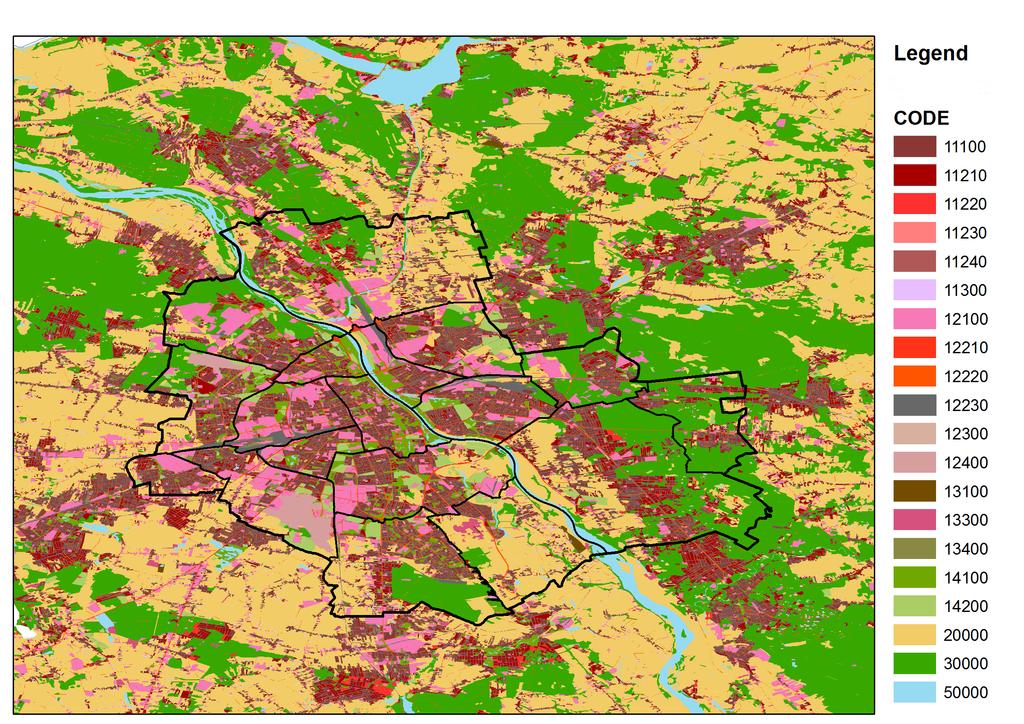
9 9
10 SUHI indicators According to the remarks given by Schwarz et al., 2011, 2012 we used several indicators in parallel 10
11 Name Brief definition 1. Standard Deviation Standard deviation of LST values within city's administrative borders 2. Magnitude Maximum LST mean LST (within city borders) 3. Range Maximum LST lowest LST (within city borders) Urban mean other Urban mean water Urban mean - agriculture Inside urban inside rural Urban core rural ring Urban core deep forest Mean LST (within city borders) mean LST (areas outside borders within a buffer) Mean LST (within city borders) LST of Zalew Zegrzyński Lake Mean LST (within city borders) LST of cropland pixel within city borders: mean LST of artificial areas mean LST of natural areas mean LST of artificial areas within city borders mean temperature in ring of pixels outside the city mean LST of artificial areas within city borders pixel covered with dense forest (Kampinos National Forest) 10. Hot island Area (px) with LST higher than mean + one std 11. Micro UHI Percentage of area (without water surfaces) with LST higher than warmest LST associated with tree canopies
12 RESULTS 12
13 3 types of weights which is the best? Spring day case 13


14 power A. number of clear-sky days B. LST retrieval errors C. combined (A+B) 1 3 types of weights which is the best?
15 LST spatial distribution in different seasons 15
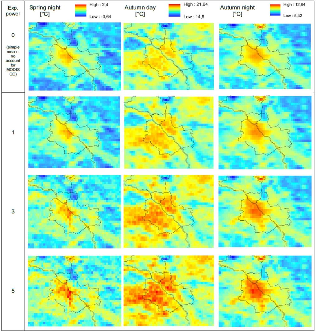

16 LST spatial distribution in different seasons 16
17 SUHI intensity 17
18 [ C] Autumn day Autumn night Spring day Spring night SUHI intensity 1. Standard Deviation 0,86 0,97 1,15 0,83 2. Magnitude 1,39 1,88 3,55 1,9 3. Range 3,92 4,56 6,75 4,51 4. Urban mean - other 0,85 1,49 1,5 1,15 5. Urban mean - water 4,26-1,71 5,93-0,02 6. Urban mean - agriculture -0,04 1,4 1,64 1,05 Inside urban inside 7. rural 1,08 1,28 1,57 1,01 8. Urban core rural ring 1,08 2,17 1,87 1,63 9. Urban core deep forest 3,03 1,45 4,21 0,6 10. Hot island [pixels] Micro UHI [%] 88,77 52,9 80,8 42,75 18
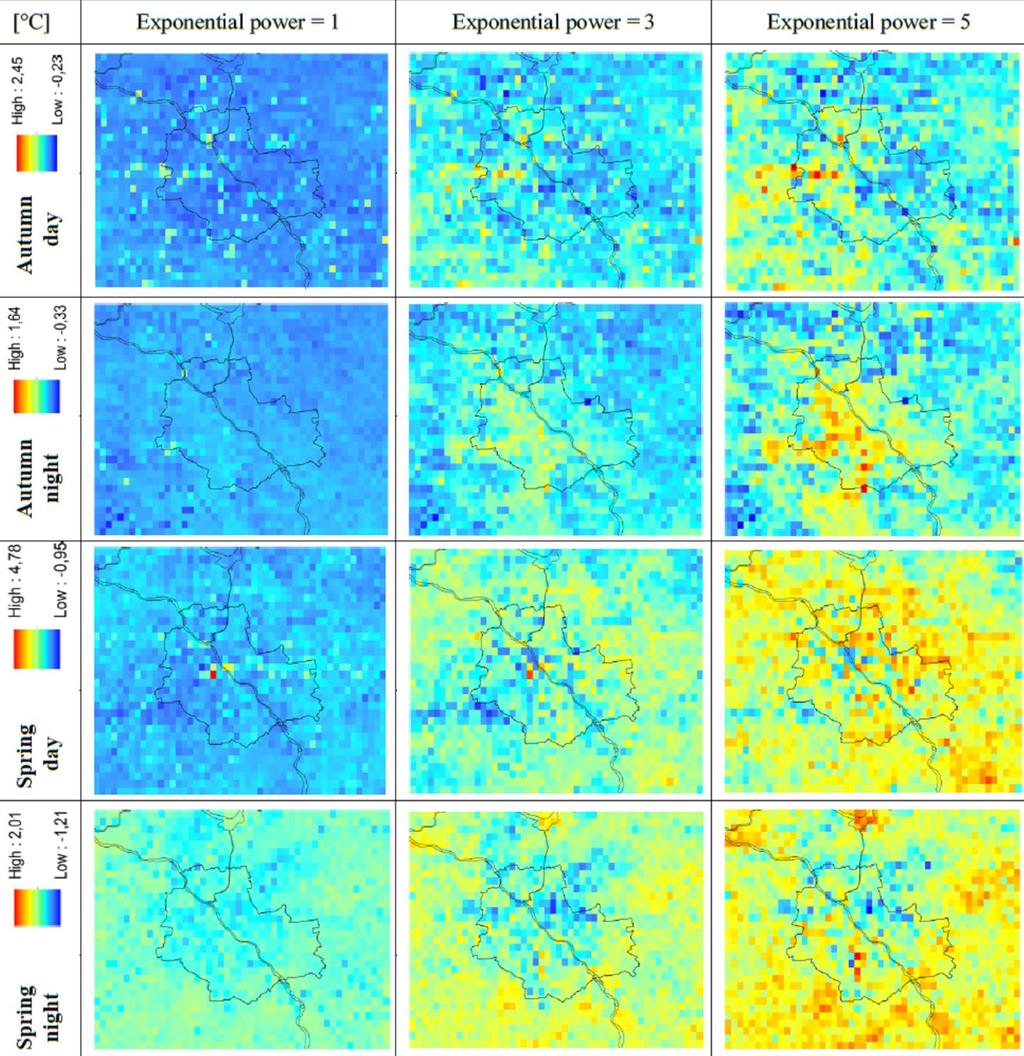
19 SUHI intensity: difference simple mean weighted mean 19
20 20
21
22 Impact of MODIS QC on urban LST pattern Location and magnitude of differences: Simple mean weighted mean 22
23
24 Relationship: LST and ISA, population density, night-time lights 24
25 Relationship: LST and ISA, population density, night-time lights 25
26 CONCLUSIONS 26
27 Conclusions temporal aggregation and urban LST pattern Weighted mean based solely on LST retrieval errors gave very unrealistic LST pattern The combination of weights based on LST retrieval errors and a number of clear-sky days gave the most realistic LST pattern The temporal aggregation process with accounting for MODIS QC metadata has a significant impact on urban LST pattern Less significant on SUHI intensity 27
28 Conclusions SUHI magnitude Behaviour of SUHI indicators is inconsistent, especially indicators expressed in area units This reveals important inconsistencies, which may lead to discrepancies in other SUHI studies. This conclusion is consistent with the findings of Schwarz et al. 2011, where it is remarked that SUHI indicators reveal low correlations between each other In spite of the certainty that SUHI phenomenon does occur in the city of Warsaw in each case analysed, it is hard to conclude about its mean 15-year intensity. However, it might be stated that the mean SUHI magnitude has at least 1 C in each analysed season and in specific cases might be much higher 28
29 Conclusions LST and ISA, population density, night-time lights In Autumn cases, temporal composition process with accounting for MODIS QC brings out the urban LST pattern more apparently (increases correlation) than without accounting for QC metadata In Spring cases temporal aggregation process suppresses the urban LST pattern (decreases correlation). This is consistent with variability of SUHI indicators with growing exponential power applied to weights. 29
30 Thank you! Contact: 30
31 Shortcomings of the study 1) The length of the analysed period the and amount of data included; it is found that temporal aggregation with accounting for MODIS QC significantly differs from the temporal aggregation without accounting for MODIS QC metadata. However, in this study the actual impact of the MODIS QC on the final LST patterns is increased by a long period of weights accumulation (15 years) and a number of utilized rasters (at least 54). In studies devoted to shorter periods with less data included such impact might be less apparent. 2) The strength of the best quality and a number of clear-sky days promotion; the highest impact of temporal aggregation with accounting for MODIS QC is revealed when a high exponential power is applied to weights during the composition process. However, this study does not give an answer what is a proper exponential power applied to weights that should be applied in similar studies. It seems logical to promote pixels with the highest quality and a maximum number of clear-sky observations, but the appropriate strength of the promotion is unknown. It should be concluded that the choice must depend on a specific case. 3) Applicability to other satellite sensors; the weights applied during the composition process were explicitly based on the quality thresholds and a number of clear-sky observations indicated by MODIS Quality Control SDS. However, applicability of the presented methodology for other satellite instruments is limited only to those products that contains appropriate metadata. 31
dated : 1 July Introduction
 Analysis of the impact of different temporal aggregation techniques of land surface temperature on SUHI indicators and the relationship of surface temperature with population density and night lighting
MODIS-BASED INVESTIGATIONS ON THE URBAN HEAT ISLANDS OF BUCHAREST (ROMANIA) AND PRAGUE (CZECH REPUBLIC)
 AND PRAGUE (CZECH REPUBLIC)") MODIS-BASED INVESTIGATIONS ON THE URBAN HEAT ISLANDS OF BUCHAREST (ROMANIA) AND PRAGUE (CZECH REPUBLIC) Sorin Cheval*, Michal Žák***, Alexandru Dumitrescu*, Vít Květoň** *National Meteorological Administration,
MODIS-BASED INVESTIGATIONS ON THE URBAN HEAT ISLANDS OF BUCHAREST (ROMANIA) AND PRAGUE (CZECH REPUBLIC) Sorin Cheval*, Michal Žák***, Alexandru Dumitrescu*, Vít Květoň** *National Meteorological Administration,
Comparing the diurnal and seasonal variabilities of atmospheric and surface urban heat islands based on the Beijing urban meteorological network
 Comparing the diurnal and seasonal variabilities of atmospheric and surface urban heat islands based on the Beijing urban meteorological network Kaicun Wang, Shaojing Jiang, Jiankai Wang, Chunlüe Zhou,
Applications of GIS and Remote Sensing for Analysis of Urban Heat Island
 Chuanxin Zhu Professor Peter V. August Professor Yeqiao Wang NRS 509 December 15, 2016 Applications of GIS and Remote Sensing for Analysis of Urban Heat Island Since the last century, the global mean surface
Spatio-Temporal Trends of Urban Heat Island and Surface Temperature in Izmir, Turkey
 American Journal of Remote Sensing 2017; 5(3): 24-29 http://www.sciencepublishinggroup.com/j/ajrs doi: 0.11648/j.ajrs.20170503.11 ISSN: 2328-5788 (Print); ISSN: 2328-580X (Online) Spatio-Temporal Trends
Mario Flores, Graduate Student Department of Applied Mathematics, UTSA. EES 5053: Remote Sensing
 Mario Flores, Graduate Student Department of Applied Mathematics, UTSA Miguel Balderas, E.I.T., Graduate Student Department of Civil/Environmental Engineering, UTSA EES 5053: Remote Sensing REMOTE SENSING
Aniekan Eyoh 1* Department of Geoinformatics & Surveying, Faculty of Environmental Studies, University of Uyo, Nigeria
 Available online at http://euroasiapub.org/journals.php, pp. 53~62 Thomson Reuters Researcher ID: L-5236-2015 TEMPORAL APPRAISAL OF LAND SURFACE TEMPERATURE DYNAMICS ACROSS THE NINE STATES OF NIGER DELTA
Modelling the Atmospheric Urban Heat Island and its Contributing Spatial Characteristics
 the Atmospheric Urban Heat Island and its Contributing Characteristics The Case of The Hague, the Netherlands Anna-Maria Ntarladima 07/11/2016 Urban Heat Island (UHI) is a phenomenon in which a city forms
An Algorithm for Retrieving Land Surface Temperatures Using VIIRS Data in Combination with Multi-Sensors
 Sensors 2014, 14, 21385-21408; doi:10.3390/s141121385 Article OPEN ACCESS sensors ISSN 1424-8220 www.mdpi.com/journal/sensors An Algorithm for Retrieving Land Surface Temperatures Using VIIRS Data in Combination
The footprint of urban heat island effect in China
 A discussion on the paper The footprint of urban heat island effect in China By Decheng Zhou, Shuqing Zhao, Liangxia Zhang, Ge Sun & Yongqiang Liu Published in SCIENCE REPORRTS Reporter: Mu Qingchen 2015.10.23
Investigating the urban climate characteristics of two Hungarian cities with SURFEX/TEB land surface model
 Investigating the urban climate characteristics of two Hungarian cities with SURFEX/TEB land surface model Gabriella Zsebeházi Gabriella Zsebeházi and Gabriella Szépszó Hungarian Meteorological Service,
Modelling the Atmospheric Urban Heat Island and its Contributing Spatial Characteristics
 the Atmospheric Urban Heat Island and its Contributing Characteristics The Case of The Hague, the Netherlands Anna-Maria Ntarladima Alexander Wandl Hugo Ledoux 02/11/2016 Urban Heat Island (UHI) is a phenomenon
Using VIIRS Land Surface Temperature to Evaluate NCEP North American Mesoscale Model (NAM) Forecast
 Forecast") Using VIIRS Land Surface Temperature to Evaluate NCEP North American Mesoscale Model (NAM) Forecast Zhuo Wang (University of Maryland) Yunyue Yu (NOAA/NESDIS/STAR) Peng Yu (University of Maryland) Yuling
Using VIIRS Land Surface Temperature to Evaluate NCEP North American Mesoscale Model (NAM) Forecast Zhuo Wang (University of Maryland) Yunyue Yu (NOAA/NESDIS/STAR) Peng Yu (University of Maryland) Yuling
Flux Tower Data Quality Analysis in the North American Monsoon Region
 Flux Tower Data Quality Analysis in the North American Monsoon Region 1. Motivation The area of focus in this study is mainly Arizona, due to data richness and availability. Monsoon rains in Arizona usually
Remote Sensing of Urban Surface Temperatures
 Remote Sensing of Urban Surface Temperatures James Voogt University of Western Ontario London, Ontario, Canada This work is supported by the Natural Sciences and Engineering Research Council of Canada.
Study of Land Surface Temperature Variations with Distance from Hot Spots for Urban Heat Island Analysis
 Study of Land Surface Temperature Variations with Distance from Hot Spots for Urban Heat Island Analysis Khandelwal, Sumit 1*, Goyal, Rohit 2, Kaul, Nivedita 1 and Singhal, Vijai 3 ABSTRACT Vegetation
Influence of Micro-Climate Parameters on Natural Vegetation A Study on Orkhon and Selenge Basins, Mongolia, Using Landsat-TM and NOAA-AVHRR Data
 Cloud Publications International Journal of Advanced Remote Sensing and GIS 2013, Volume 2, Issue 1, pp. 160-172, Article ID Tech-102 ISSN 2320-0243 Research Article Open Access Influence of Micro-Climate
Study of Urban heat Island Effect on Ahmedabad City and Its Relationship with Urbanization and Vegetation Parameters
 Study of Urban heat Island Effect on Ahmedabad City and Its Relationship with Urbanization and Vegetation Parameters Aneesh Mathew a,*, Rishabh Chaudhary a, Neha Gupta a, a Research Scholar, Department
Remote sensing Based Assessment of Urban Heat Island Phenomenon in Nagpur Metropolitan Area
 International Journal of Information & Computation Technology. ISSN 0974-2239 Volume 4, Number 11 (2014), pp. 1069-1074 International Research Publications House http://www. irphouse.com Remote sensing
How Researchers Measure Urban Heat Islands. James Voogt Department of Geography, University of Western Ontario London ON Canada
 How Researchers Measure Urban Heat Islands James Voogt Department of Geography, University of Western Ontario London ON Canada Outline What is the urban heat island? What types of urban heat islands exist?
DROUGHT ASSESSMENT USING SATELLITE DERIVED METEOROLOGICAL PARAMETERS AND NDVI IN POTOHAR REGION
 DROUGHT ASSESSMENT USING SATELLITE DERIVED METEOROLOGICAL PARAMETERS AND NDVI IN POTOHAR REGION Researcher: Saad-ul-Haque Supervisor: Dr. Badar Ghauri Department of RS & GISc Institute of Space Technology
Comparison between Land Surface Temperature Retrieval Using Classification Based Emissivity and NDVI Based Emissivity
 Comparison between Land Surface Temperature Retrieval Using Classification Based Emissivity and NDVI Based Emissivity Isabel C. Perez Hoyos NOAA Crest, City College of New York, CUNY, 160 Convent Avenue,
THE USE OF REMOTE SENSING AND GEOSPATIAL TECHNIQUES FOR URBAN CLIMATE ANALYSIS: A CASE STUDY OF ABU DHABI CITY AREA
 THE USE OF REMOTE SENSING AND GEOSPATIAL TECHNIQUES FOR URBAN CLIMATE ANALYSIS: A CASE STUDY OF ABU DHABI CITY AREA Michele Lazzarini, Jacinto Estima, Prashanth Reddy Marpu, Hosni Ghedira Earth Observation
Remote Sensing Applications for Land/Atmosphere: Earth Radiation Balance
 Remote Sensing Applications for Land/Atmosphere: Earth Radiation Balance - Introduction - Deriving surface energy balance fluxes from net radiation measurements - Estimation of surface net radiation from
Estimation of evapotranspiration using satellite TOA radiances Jian Peng
 Estimation of evapotranspiration using satellite TOA radiances Jian Peng Max Planck Institute for Meteorology Hamburg, Germany Satellite top of atmosphere radiances Slide: 2 / 31 Surface temperature/vegetation
CORRELATION BETWEEN URBAN HEAT ISLAND EFFECT AND THE THERMAL INERTIA USING ASTER DATA IN BEIJING, CHINA
 CORRELATION BETWEEN URBAN HEAT ISLAND EFFECT AND THE THERMAL INERTIA USING ASTER DATA IN BEIJING, CHINA Yurong CHEN a, *, Mingyi DU a, Rentao DONG b a School of Geomatics and Urban Information, Beijing
SENSITIVITY STUDY FOR SZEGED, HUNGARY USING THE SURFEX/TEB SCHEME COUPLED TO ALARO
 SENSITIVITY STUDY FOR SZEGED, HUNGARY USING THE SURFEX/TEB SCHEME COUPLED TO ALARO Report from the Flat-Rate Stay at the Royal Meteorological Institute, Brussels, Belgium 11.03.2015 01.04.2015 Gabriella
FOREST FIRE HAZARD MODEL DEFINITION FOR LOCAL LAND USE (TUSCANY REGION)
") FOREST FIRE HAZARD MODEL DEFINITION FOR LOCAL LAND USE (TUSCANY REGION) C. Conese 3, L. Bonora 1, M. Romani 1, E. Checcacci 1 and E. Tesi 2 1 National Research Council - Institute of Biometeorology (CNR-
FOREST FIRE HAZARD MODEL DEFINITION FOR LOCAL LAND USE (TUSCANY REGION) C. Conese 3, L. Bonora 1, M. Romani 1, E. Checcacci 1 and E. Tesi 2 1 National Research Council - Institute of Biometeorology (CNR-
An Analysis of Urban Cooling Island (UCI) Effects by Water Spaces Applying UCI Indices
 Effects by Water Spaces Applying UCI Indices") An Analysis of Urban Cooling Island (UCI) Effects by Water Spaces Applying UCI Indices D. Lee, K. Oh, and J. Seo Abstract An urban cooling island (UCI) involves an area that has a lower temperature compared
An Analysis of Urban Cooling Island (UCI) Effects by Water Spaces Applying UCI Indices D. Lee, K. Oh, and J. Seo Abstract An urban cooling island (UCI) involves an area that has a lower temperature compared
Outline. Artificial night lighting as seen from space. Artificial night lighting as seen from space. Applications based on DMSP nighttime lights
 -1 - Outline Satellite observed nighttime lights as an indicator of human induced stress on coral C. Aubrecht, C.D. Elvidge August 22, 2008 Kuffner Observatory Vienna, Austria Artificial night lighting
Urban remote sensing: from local to global and back
 Urban remote sensing: from local to global and back Paolo Gamba University of Pavia, Italy A few words about Pavia Historical University (1361) in a nice town slide 3 Geoscience and Remote Sensing Society
What is so great about nighttime VIIRS data for the detection and characterization of combustion sources?
 Proceedings of the Asia-Pacific Advanced Network 2013 v. 35, p. 33-48. http://dx.doi.org/10.7125/apan.35.5 ISSN 2227-3026 What is so great about nighttime VIIRS data for the detection and characterization
COMPARISON OF NOAA/AVHRR AND LANDSAT/TM DATA IN TERMS OF RESEARCH APPLICATIONS ON THERMAL CONDITIONS IN URBAN AREAS
 COMPARISON OF NOAA/AVHRR AND LANDSAT/TM DATA IN TERMS OF RESEARCH APPLICATIONS ON THERMAL CONDITIONS IN URBAN AREAS Monika J. Hajto 1 *, Jakub P. Walawender 2,3 and Piotr Struzik 2 1 Department of Air
ISO MODIS NDVI Weekly Composites for Canada South of 60 N Data Product Specification
 ISO 19131 MODIS NDVI Weekly Composites for South of 60 N Data Product Specification Revision: A Data specification: MODIS NDVI Composites for South of 60 N - Table of Contents - 1. OVERVIEW... 3 1.1. Informal
How reliable are selected methods of projections of future thermal conditions? A case from Poland
 How reliable are selected methods of projections of future thermal conditions? A case from Poland Joanna Wibig Department of Meteorology and Climatology, University of Łódź, Outline 1. Motivation Requirements
Evaluation of land surface temperature (LST) patterns in the urban agglomeration of Krakow using different satellite data and GIS
 patterns in the urban agglomeration of Krakow using different satellite data and GIS") Evaluation of land surface temperature (LST) patterns in the urban agglomeration of Krakow using different satellite data and GIS Jakub P. Walawender 1,2 1 Satellite Remote Sensing Centre, Institute of
Evaluation of land surface temperature (LST) patterns in the urban agglomeration of Krakow using different satellite data and GIS Jakub P. Walawender 1,2 1 Satellite Remote Sensing Centre, Institute of
MODELING URBAN THERMAL ANISOTROPY
 MODELING URBAN THERMAL ANISOTROPY J. A. Voogt a, *, E. S. Krayenhoff a a Department of Geography, University of Western Ontario, London ON N6A 5C2 Canada -javoogt@uwo.ca KEY WORDS: surface temperature,
Comparison of NASA AIRS and MODIS Land Surface Temperature and Infrared Emissivity Measurements from the EOS AQUA platform
 Comparison of NASA AIRS and MODIS Land Surface Temperature and Infrared Emissivity Measurements from the EOS AQUA platform Robert Knuteson, Steve Ackerman, Hank Revercomb, Dave Tobin University of Wisconsin-Madison
Critical review of the Climate Change Impact on urban areas by assessment of Heat Island effect
 Critical review of the Climate Change Impact on urban areas by assessment of Heat Island effect Case of Pune, India Town Planning, Civil Department Prof. Omkar Parishwad, ogp.civil@coep.ac.in Climate Change
ASSESSING THERMAL RISK IN URBAN AREAS AN APPLICATION FOR THE URBAN AGGLOMERATION OF ATHENS
 ASSESSING THERMAL RISK IN URBAN AREAS AN APPLICATION FOR THE URBAN AGGLOMERATION OF ATHENS Polydoros T. and Cartalis C. Department of Environmental Physics, University of Athens, University Campus, Build
High-resolution simulations of the Urban Heat Island
 24 October 2013 High-resolution simulations of the Urban Heat Island Andrew Monaghan, Michael Barlage, Leiqiu Hu, Nathan Brunsell, Johannes Feddema, Keith Oleson, Olga Wilhelmi and Steve Sain 1 (Oleson
Where a licence is displayed above, please note the terms and conditions of the licence govern your use of this document.
 Birmingham s air and surface urban heat islands associated with Lamb weather types and cloudless anticyclonic conditions Zhang, Fang; Cai, Xiaoming; Thornes, John DOI:.1177/03091333143872 License: Other
EXTRACTION OF REMOTE SENSING INFORMATION OF BANANA UNDER SUPPORT OF 3S TECHNOLOGY IN GUANGXI PROVINCE
 EXTRACTION OF REMOTE SENSING INFORMATION OF BANANA UNDER SUPPORT OF 3S TECHNOLOGY IN GUANGXI PROVINCE Xin Yang 1,2,*, Han Sun 1, 2, Zongkun Tan 1, 2, Meihua Ding 1, 2 1 Remote Sensing Application and Test
Evaluation of updated JXAM5 snow cover extent product using ground based snow depth information
 2 nd International Satellite Snow Product Intercomparison Workshop ISSPI-2 University Memorial Center (UMC), University of Colorado Boulder, 14-16 September 2015 Evaluation of updated JXAM5 snow cover
COMPARASION OF NDBI AND NDVI AS INDICATORS OF SURFACE URBAN HEAT ISLAND EFFECT IN LANDSAT 8 IMAGERY: A CASE STUDY OF IASI
 DOI 10.1515/pesd-2017-0032 PESD, VOL. 11, no. 2, 2017 COMPARASION OF NDBI AND NDVI AS INDICATORS OF SURFACE URBAN HEAT ISLAND EFFECT IN LANDSAT 8 IMAGERY: A CASE STUDY OF IASI Paul Macarof 1, Florian Statescu
C o p e r n i c u s L a n d M o n i t o r i n g S e r v i c e
 C o p e r n i c u s L a n d M o n i t o r i n g S e r v i c e Integration into existing Snow and Ice Services and draft product specifications Annett BARTSCH b.geos Copernicus High Resolution Snow and
Lancaster Environment Centre, Lancaster University, Lancaster, LA1 4YQ, UK;
 Title Page Dynamics and controls of urban heat sink and island phenomena in a desert city: development of a local climate zone scheme using remotely-sensed inputs Ahmed K. NASSAR (corresponding author)
Estimation of ocean contribution at the MODIS near-infrared wavelengths along the east coast of the U.S.: Two case studies
 GEOPHYSICAL RESEARCH LETTERS, VOL. 32, L13606, doi:10.1029/2005gl022917, 2005 Estimation of ocean contribution at the MODIS near-infrared wavelengths along the east coast of the U.S.: Two case studies
On the use of satellite remote sensing to determine direct aerosol radiative effect over land : A case study over China
 On the use of satellite remote sensing to determine direct aerosol radiative effect over land : A case study over China Anu-Maija Sundström, Antti Arola, Pekka Kolmonen, Gerrit de Leeuw, and Markku Kulmala
Evaluating Urban Vegetation Cover Using LiDAR and High Resolution Imagery
 Evaluating Urban Vegetation Cover Using LiDAR and High Resolution Imagery Y.A. Ayad and D. C. Mendez Clarion University of Pennsylvania Abstract One of the key planning factors in urban and built up environments
ANALYSIS AND VALIDATION OF A METHODOLOGY TO EVALUATE LAND COVER CHANGE IN THE MEDITERRANEAN BASIN USING MULTITEMPORAL MODIS DATA
 PRESENT ENVIRONMENT AND SUSTAINABLE DEVELOPMENT, NR. 4, 2010 ANALYSIS AND VALIDATION OF A METHODOLOGY TO EVALUATE LAND COVER CHANGE IN THE MEDITERRANEAN BASIN USING MULTITEMPORAL MODIS DATA Mara Pilloni
Assessing Drought in Agricultural Area of central U.S. with the MODIS sensor
 Assessing Drought in Agricultural Area of central U.S. with the MODIS sensor Di Wu George Mason University Oct 17 th, 2012 Introduction: Drought is one of the major natural hazards which has devastating
1.6 ALASKA LARGE FOREST FIRES IN 2004 AND WEATHER - Discussion based on satellite and weather data
 1.6 ALASKA LARGE FOREST FIRES IN 2004 AND WEATHER - Discussion based on satellite and weather data Hiroshi Hayasaka*, K. Nakau*, K. Kushida*, M. Fukuda*, P. Martyn**, and T. DeFries** * Hokkaido Univ.,
EVALUATION OF MERIS AEROSOL PRODUCTS FOR NATIONAL AND REGIONAL AIR QUALITY IN AUSTRIA
 EVALUATION OF MERIS AEROSOL PRODUCTS FOR NATIONAL AND REGIONAL AIR QUALITY IN AUSTRIA Robert Höller (1),*, Christian Nagl (1), Herbert Haubold (1), Ludovic Bourg (2), Odile Fanton d Andon (2), and Philippe
RESEARCHER ESTIMATION OF EVAPORATION LOSSES FROM LAKE NASSER USING REMOTE SENSING AND GIS RASTER CALCULATOR MODEL
 RESEARCHER ESTIMATION OF EVAPORATION LOSSES FROM LAKE NASSER USING REMOTE SENSING AND GIS RASTER CALCULATOR MODEL Hala M. Ebaid Researcher, Survey Research Institute, National Water Research Center, E-Mail:hala_sri@yahoo.com
Spatial Disaggregation of Land Cover and Cropping Information: Current Results and Further steps
 CAPRI CAPRI Spatial Disaggregation of Land Cover and Cropping Information: Current Results and Further steps Renate Koeble, Adrian Leip (Joint Research Centre) Markus Kempen (Universitaet Bonn) JRC-AL
AGRICULTURE DROUGHT AND FOREST FIRE MONITORING IN CHONGQING CITY WITH MODIS AND METEOROLOGICAL OBSERVATIONS *
 AGRICULTURE DROUGHT AND FOREST FIRE MONITORING IN CHONGQING CITY WITH MODIS AND METEOROLOGICAL OBSERVATIONS * HONGRUI ZHAO a ZHONGSHI TANG a, BIN YANG b AND MING ZHAO a a 3S Centre, Tsinghua University,
ESTIMATION OF ATMOSPHERIC COLUMN AND NEAR SURFACE WATER VAPOR CONTENT USING THE RADIANCE VALUES OF MODIS
 ESTIMATION OF ATMOSPHERIC COLUMN AND NEAR SURFACE WATER VAPOR CONTENT USIN THE RADIANCE VALUES OF MODIS M. Moradizadeh a,, M. Momeni b, M.R. Saradjian a a Remote Sensing Division, Centre of Excellence
Results of the ESA-DUE UHI project
 13/12/2011 Results of the ESA-DUE UHI project Bino Maiheu (bino.maiheu@vito.be), on behalf of the UHI project Outline» Urban heat island problem» The ESA-DUE urban heat island project» UHI air temperature
CLAVR-x is the Clouds from AVHRR Extended Processing System. Responsible for AVHRR cloud products and other products at various times.
 CLAVR-x in CSPP Andrew Heidinger, NOAA/NESDIS/STAR, Madison WI Nick Bearson, SSEC, Madison, WI Denis Botambekov, CIMSS, Madison, WI Andi Walther, CIMSS, Madison, WI William Straka III, CIMSS, Madison,
Satellite-based Lake Surface Temperature (LST) Homa Kheyrollah Pour Claude Duguay
 Homa Kheyrollah Pour Claude Duguay") Satellite-based Lake Surface Temperature (LST) Homa Kheyrollah Pour Claude Duguay Lakes in NWP models Interaction of the atmosphere and underlying layer is the most important issue in climate modeling
Satellite-based Lake Surface Temperature (LST) Homa Kheyrollah Pour Claude Duguay Lakes in NWP models Interaction of the atmosphere and underlying layer is the most important issue in climate modeling
MODIS and VIIRS Reflective Solar Bands Calibration, Performance, and Inter-comparison
 EOS MODIS and VIIRS Reflective Solar Bands Calibration, Performance, and Inter-comparison Jack Xiong 1, Aisheng Wu 1, and Changyong Cao 2 1. NASA/GSFC; 2. NOAA/STAR Other Contributors: NASA MCST and VCST
ACTRIS aerosol vertical profiles: advanced data and their potential use in a aerosol observations/models combined approach
 ACTRIS aerosol vertical profiles: advanced data and their potential use in a aerosol observations/models combined approach Lucia Mona CNR-IMAA, Potenza, Italy mona@imaa.cnr.it and EARLINET Team OUTLINE
Patrick Leinenkugel. German Aerospace Center (DLR) Vortrag > Autor > Dokumentname > Datum
 Vortrag > Autor > Dokumentname > Datum") Characterisation of land surface phenology and land cover for the Mekong Basin on the basis of multitemporal and multispectral satellite data from the MODIS Sensor Patrick Leinenkugel German Aerospace
Characterisation of land surface phenology and land cover for the Mekong Basin on the basis of multitemporal and multispectral satellite data from the MODIS Sensor Patrick Leinenkugel German Aerospace
Observing land from space: Interacting with land data from NASA s LP DAAC
 Observing land from space: Interacting with land data from NASA s LP DAAC Danielle Golon Innovate! Inc., contractor to the U.S. Geological Survey (USGS) Earth Resources Observation and Science (EROS) Center
Case study of an urban heat island in London, UK: Comparison between observations and a high resolution numerical weather prediction model
 Case study of an urban heat island in London, UK: Comparison between observations and a high resolution numerical weather prediction model Siân Lane, Janet Barlow, Humphrey Lean With thanks to Christos
New Opportunities in Urban Remote Sensing. Philip Christensen Arizona State University
 New Opportunities in Urban Remote Sensing Philip Christensen Arizona State University Advantages: Uniform, global data Role of Remote Sensing Repeatable at regular intervals over long periods of time Broad
NESDIS Global Automated Satellite Snow Product: Current Status and Planned Upgrades Peter Romanov
 NESDIS Global Automated Satellite Snow Product: Current Status and Planned Upgrades Peter Romanov NOAA-CREST, City University of New York (CUNY) Center for Satellite Applications and Research (STAR), NOAA/NESDIS
URBAN HEAT ISLAND IN SEOUL
 URBAN HEAT ISLAND IN SEOUL Jong-Jin Baik *, Yeon-Hee Kim ** *Seoul National University; ** Meteorological Research Institute/KMA, Korea Abstract The spatial and temporal structure of the urban heat island
NESDIS Polar (Region) Products and Plans. Jeff Key NOAA/NESDIS Madison, Wisconsin USA
 Products and Plans. Jeff Key NOAA/NESDIS Madison, Wisconsin USA") NESDIS Polar (Region) Products and Plans Jeff Key NOAA/NESDIS Madison, Wisconsin USA WMO Polar Space Task Group, 2 nd meeting, Geneva, 12 14 June 2012 Relevant Missions and Products GOES R ABI Fractional
NESDIS Polar (Region) Products and Plans Jeff Key NOAA/NESDIS Madison, Wisconsin USA WMO Polar Space Task Group, 2 nd meeting, Geneva, 12 14 June 2012 Relevant Missions and Products GOES R ABI Fractional
Abstract: Introduction: 10 th ESRI India User Conference 2009 Geography in Action
 Mitigation of Thermal Pollution to enhance urban air quality through Remote Sensing and GIS Anshu Gupta, Lecturer, Centre of Remote Sensing and GIS, MANIT, Bhopal, E- mail: anshugupta20002001@gmail.com
ENHANCED SNOW COVER ALGORITHM BASED ON 250 M MODIS IMAGES FOR MONITORING TEMPORAL AND SPATIAL CHANGES IN THE MOUNTAIN AREAS
 1st Internationational Satellite Snow Product Intercomparison Workshop, 21-23 July College Park, MD ENHANCED SNOW COVER ALGORITHM BASED ON 250 M MODIS IMAGES FOR MONITORING TEMPORAL AND SPATIAL CHANGES
A new perspective on aerosol direct radiative effects in South Atlantic and Southern Africa
 A new perspective on aerosol direct radiative effects in South Atlantic and Southern Africa Ian Chang and Sundar A. Christopher Department of Atmospheric Science University of Alabama in Huntsville, U.S.A.
Estimation of the area of sealed soil using GIS technology and remote sensing
 From the SelectedWorks of Przemysław Kupidura 2010 Estimation of the area of sealed soil using GIS technology and remote sensing Stanisław Białousz Przemysław Kupidura Available at: https://works.bepress.com/przemyslaw_kupidura/14/
EXAMINATIONS ON THE ROLE OF SYNOPTIC CONDITIONS IN URBAN HEAT ISLAND DEVELOPMENT IN DEBRECEN
 EXAMINATIONS ON THE ROLE OF SYNOPTIC CONDITIONS IN URBAN HEAT ISLAND DEVELOPMENT IN DEBRECEN Sándor SZEGEDI, Tamás TÓTH, István LÁZÁR, Elemér LÁSZLÓ Department of Meteorology, University of Debrecen, Hungary
Remote Sensing Based Inversion of Gap Fraction for Determination of Leaf Area Index. Alemu Gonsamo 1 and Petri Pellikka 1
 Remote Sensing Based Inversion of Gap Fraction for Determination of Leaf Area Index Alemu Gonsamo and Petri Pellikka Department of Geography, University of Helsinki, P.O. Box, FIN- Helsinki, Finland; +-()--;
Quantifying the influence of wind advection on the urban heat island for an improvement of a climate change adaptation planning tool
 Quantifying the influence of wind advection on the urban heat island for an improvement of a climate change adaptation planning tool BEAR conference 15/12/2014 Bassett R., Cai X., Chapman L., Heaviside
Module 3 Indicator Land Consumption Rate to Population Growth Rate
 Regional Training Workshop on Human Settlement Indicators Module 3 Indicator 11.3.1 Land Consumption Rate to Population Growth Rate Dennis Mwaniki Global Urban Observatory, Research and Capacity Development
Evaluation of a MODIS Triangle-based Algorithm for Improving ET Estimates in the Northern Sierra Nevada Mountain Range
 Evaluation of a MODIS Triangle-based Algorithm for Improving ET Estimates in the Northern Sierra Nevada Mountain Range Kyle R. Knipper 1, Alicia M. Kinoshita 2, and Terri S. Hogue 1 January 5 th, 2015
1. Introduction. Chaithanya, V.V. 1, Binoy, B.V. 2, Vinod, T.R. 2. Publication Date: 8 April DOI: https://doi.org/ /cloud.ijarsg.
 Cloud Publications International Journal of Advanced Remote Sensing and GIS 2017, Volume 6, Issue 1, pp. 2088-2096 ISSN 2320 0243, Crossref: 10.23953/cloud.ijarsg.112 Research Article Open Access Estimation
ESTIMATING TEMPORAL LAND SURFACE TEMPERATURE USING REMOTE SENSING: A STUDY OF VADODARA URBAN AREA, GUJARAT
 ESTIMATING TEMPORAL LAND SURFACE TEMPERATURE USING REMOTE SENSING: A STUDY OF VADODARA URBAN AREA, GUJARAT Janak P. Joshi and *Bindu Bhatt Department of Geography, Faculty of Science, the Maharaja Sayajirao
ANNUAL SPATIO-TEMPORAL VARIABILITY OF TOULOUSE URBAN HEAT ISLAND. Grégoire Pigeon* and Valéry Masson CNRM-GAME, Météo France-CNRS, Toulouse, France
 J12.4A ANNUAL SPATIO-TEMPORAL VARIABILITY OF TOULOUSE URBAN HEAT ISLAND Grégoire Pigeon* and Valéry Masson CNRM-GAME, Météo France-CNRS, Toulouse, France 1 INTRODUCTION The urban heat island (UHI) has
Research Article A Quantitative Assessment of Surface Urban Heat Islands Using Satellite Multitemporal Data over Abeokuta, Nigeria
 International Atmospheric Sciences Volume 2016, Article ID 3170789, 6 pages http://dx.doi.org/10.1155/2016/3170789 Research Article A Quantitative Assessment of Surface Urban Heat Islands Using Satellite
SENSITIVITY OF THE SURFEX LAND SURFACE MODEL TO FORCING SETTINGS IN URBAN CLIMATE MODELLING
 SENSITIVITY OF THE SURFEX LAND SURFACE MODEL TO FORCING SETTINGS IN URBAN CLIMATE MODELLING Gabriella Zsebeházi PhD supervisor: Gabriella Szépszó Regional Climate Modelling Group, Hungarian Meteorological
Identifying Hot Spots in Urban Areas in support of Microclimatic Studies in the City of Athens, including its Historic Centre
 Identifying Hot Spots in Urban Areas in support of Microclimatic Studies in the City of Athens, including its Historic Centre Constantinos Cartalis, Mattheos Santamouris, Dimosthenis Asimakopoulos, Anastasios
Interannual variation of MODIS NDVI in Lake Taihu and its relation to climate in submerged macrophyte region
 Yale-NUIST Center on Atmospheric Environment Interannual variation of MODIS NDVI in Lake Taihu and its relation to climate in submerged macrophyte region ZhangZhen 2015.07.10 1 Outline Introduction Data
Using Temperature and Dew Point to Aid Forecasting Springtime Radiational Frost and/or Freezing Temperatures in the NWS La Crosse Service Area
 Using Temperature and Dew Point to Aid Forecasting Springtime Radiational Frost and/or Freezing Temperatures in the NWS La Crosse Service Area WFO La Crosse Climatology Series #21 The formation of radiational
Mapping of UTCI in local scale (the case of Warsaw) Krzysztof BłaŜejczyk
 Krzysztof BłaŜejczyk") Prace i Studia Geograficzne WGSR UW, 47, 2011, p. 275-283 Mapping of UTCI in local scale (the case of Warsaw) Krzysztof BłaŜejczyk Faculty of Geography and Regional Studies, University of Warsaw, Poland
Prace i Studia Geograficzne WGSR UW, 47, 2011, p. 275-283 Mapping of UTCI in local scale (the case of Warsaw) Krzysztof BłaŜejczyk Faculty of Geography and Regional Studies, University of Warsaw, Poland
Impact of urbanization on boundary layer structure in Beijing
 Climatic Change (13) 1:13 136 DOI 1.17/s1584-13-788- Impact of urbanization on boundary layer structure in Beijing Miao Yu & Yimin Liu & Yifeng Dai & Aqiang Yang Received: 6 October 1 / Accepted: 6 May
McIDAS support of Suomi-NPP /JPSS and GOES-R L2
 McIDAS support of Suomi-NPP /JPSS and GOES-R L2 William Straka III 1 Tommy Jasmin 1, Bob Carp 1 1 Cooperative Institute for Meteorological Satellite Studies, Space Science and Engineering Center, University
Open Access Earth Observation in Support of Urban Resilience and Climate Adaptability
 Send Orders for Reprints to reprints@benthamscience.ae The Open Remote Sensing Journal, 2015, 6, 17-22 17 Open Access Earth Observation in Support of Urban Resilience and Climate Adaptability Plans C.
Analysis of Relative Importance of Parameters Representing Vegetation, Urbanization and Elevation with Land Surface Temperature using ANN
 Analysis of Relative Importance of Parameters Representing Vegetation, Urbanization and Elevation with Land Surface Temperature using ANN Goyal, Rohit 1, Khandelwal, Sumit 2 and Kaul, Nivedita 2 ABSTRACT
First steps toward a comparison of modelled thermal comfort during a heatwave in Melbourne, Australia
 First steps toward a comparison of modelled thermal comfort during a heatwave in Melbourne, Australia Stephanie Jacobs PhD supervisors: Ailie Gallant and Nigel Tapper Outline of talk Motivation for research
Study of wind variability over Moscow city by sodar
 IOP Conference Series: Earth and Environmental Science Study of wind variability over Moscow city by sodar To cite this article: V P Yushkov 2008 IOP Conf. Ser.: Earth Environ. Sci. 1 012046 View the article
SIMPLE ESTIMATION OF AIR TEMPERATURE FROM MODIS LST IN GIFU CITY, JAPAN
 SIMPLE ESTIMATION OF AIR TEMPERATURE FROM MODIS LST IN GIFU CITY, JAPAN Ali Rahmat The United Graduate School of Agricultural Science, Gifu University, 1-1 Yanagido, Gifu 501-1193, Japan Abstract: In the
Creating a cloud-free MODIS snow cover product using spatial and temporal interpolation and temperature thresholds
 Creating a cloud-free MODIS snow cover product using spatial and temporal interpolation and temperature thresholds Justinas Kilpys, Egidijus Rimkus, Silvija Pipiraitė Vilnius University, Institute of Geosciences
Urban Tree Canopy Assessment Purcellville, Virginia
 GLOBAL ECOSYSTEM CENTER www.systemecology.org Urban Tree Canopy Assessment Purcellville, Virginia Table of Contents 1. Project Background 2. Project Goal 3. Assessment Procedure 4. Economic Benefits 5.
Estimation of Wavelet Based Spatially Enhanced Evapotranspiration Using Energy Balance Approach
 Estimation of Wavelet Based Spatially Enhanced Evapotranspiration Using Energy Balance Approach Dr.Gowri 1 Dr.Thirumalaivasan 2 1 Associate Professor, Jerusalem College of Engineering, Department of Civil
Spatial Drought Assessment Using Remote Sensing and GIS techniques in Northwest region of Liaoning, China
 Spatial Drought Assessment Using Remote Sensing and GIS techniques in Northwest region of Liaoning, China FUJUN SUN, MENG-LUNG LIN, CHENG-HWANG PERNG, QIUBING WANG, YI-CHIANG SHIU & CHIUNG-HSU LIU Department
Assimilation of satellite fapar data within the ORCHIDEE biosphere model and its impacts on land surface carbon and energy fluxes
 Laboratoire des Sciences du Climat et de l'environnement Assimilation of satellite fapar data within the ORCHIDEE biosphere model and its impacts on land surface carbon and energy fluxes CAMELIA project