LIO Topographic Data Cache
|
|
|
- Lesley Curtis
- 5 years ago
- Views:
Transcription

1 User Guide for LIO Topographic Data Cache Provincial Mapping Unit Mapping and Information Resources Branch Corporate Management and Information Division Ministry of Natural Resources and Forestry
2 Disclaimer This technical documentation has been prepared by Her Majesty the Queen in right of Ontario as represented by the Ministry of Natural Resources and Forestry (the Ministry ). No warranties or representations, express or implied, statutory or otherwise shall apply or are being made by the Ministry with respect to the documentation, its accuracy or its completeness. In no event will the Ministry be liable or responsible for any lost profits, loss of revenue or earnings, claims by third parties or for any economic, indirect, special, incidental, consequential or exemplary damage resulting from any errors, inaccuracies or omissions in this documentation; and in no event will the Ministry s liability for any such errors, inaccuracies or omissions on any particular claim, proceeding or action, exceed the actual consideration paid by the claimant involved to the Ministry for the materials to which this instructional documentation relates. Save and except for the liability expressly provided for above, the Ministry shall have no obligation, duty or liability whatsoever in contract, tort or otherwise, including any liability or negligence. The limitations, exclusions and disclaimers expressed above shall apply irrespective of the nature of any cause of action, demand or action, including but not limited to breach of contract, negligence, strict liability, tort or any other legal theory, and shall survive any fundamental breach or breaches. Cette publication spécialisée n est disponible qu en anglais. Additional Information This document does not comply with all the applicable guidelines for accessible digital documents. For an alternative format please Provincial Mapping Unit at pmu@ontario.ca. For more information about this document, please contact Provincial Mapping Unit at pmu@ontario.ca. 2019, Queen s Printer for Ontario 2
3 Executive Summary Key Words LIO Topographic Data Cache, Land Information Ontario Abstract This user guide provides information about the Land Information Ontario (LIO) Topographic Data Cache. The cache is a collection of topographic data that has been built using a series of pre-drawn maps that are compressed for fast, seamless display at predefined scales. 3
4 Table of Contents Disclaimer... 2 Additional Information... 2 Executive Summary... 3 Key Words... 3 Abstract... 3 Table of Contents... 4 List of Acronyms Introduction Objectives LIO Topographic Data Cache Links to Additional Information... 8 APPENDIX A: LIO Topographic Data Cache Legend
5 List of Acronyms LIO: Land Information Ontario MNRF: Ontario Ministry of Natural Resources and Forestry NHPN: National Highway Planning Network RITA/BTS: Research and Innovative Technology Administration's Bureau of Transportation Statistics 5
6 1. Introduction The LIO Topographic Data Cache is a visually appealing cartographic product provided for use as a base map of Ontario s features. The cache contains authoritative data for features such as road names, township boundaries and water features. Forty-three data layers make up the LIO Topographic Data Cache, which is a fundamental component of the MNRF Make a Topographic Map application. Contact LIO to request a copy of the cache for use in mapping applications. 2. Objectives This user guide is intended for users of the LIO Topographic Data Cache. The remainder of this document describes the cache and the data layers used in its creation. 3. LIO Topographic Data Cache The LIO Topographic Data Cache is a collection of topographic data that has been built using a series of pre-drawn maps that are compressed for fast, seamless display at predefined scales. The topographic data consists of constructed and natural features that make up the landscape of the Province of Ontario. The cache provides limited data from areas outside the province's boundaries, i.e. the United States and adjacent provinces and territories. The cache is updated annually. The contributing data layers may have different maintenance and update cycles. Some cache layers have been processed to optimize their display in a cartographic product. Other layers are unchanged from the authoritative data and simply symbolized. The cartographic symbology used in the data cache is intentionally muted to allow users to showcase their data. Because the LIO Topographic Data Cache is a derived product, users are directed to download the authoritative data from the Land Information Ontario website. 6
7 The cache uses a Web Mercator projection and standard scales (ESRI ArcGIS Online, Google) for familiarity. For more information, refer to ArcGIS Online moving to Google / Bing tiling scheme: What does this mean for you? Having the same projection, zoom levels and tiling scheme makes it easier for users to mash-up their own maps with other caches. Data was acquired from the following sources: Land Information Ontario Ministry of Natural Resources and Forestry GeoGratis United States - Department of Transportation - Research and Innovative Technology Administration's Bureau of Transportation Statistics For a list of the Layers in the LIO Topographic Data Cache please see the related spreadsheet Layers in the LIO Topographic Data Cache. For more information on the LIO Topographic Data Cache contact lio@ontario.ca. We want your feedback. Please a screen capture of the missing data or error to lio@ontario.ca. Submissions will be reviewed and considered where appropriate. 7
8 4. Links to Additional Information Land Information Ontario (LIO) ( Layers in the LIO Topographic Data Cache ( Topographic-Data-Cache.xlsm) Official LIO Metadata Record for the LIO Topographic Data Cache ( f172-f6cf-46da-a beabc556a) The Make a Topographic Map application ( Ontario Ministry of Natural Resources and Forestry ( 8

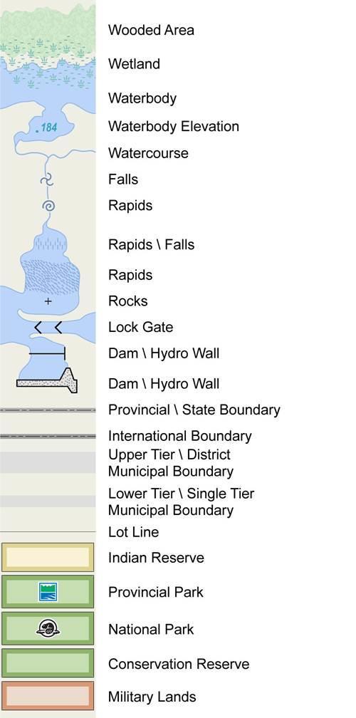
9 APPENDIX A: LIO Topographic Data Cache Legend 9
10 10
11 Version
Southwestern Ontario Orthophotography Project (SWOOP) 2015 Digital Elevation Model
 2015 Digital Elevation Model") Southwestern Ontario Orthophotography Project (SWOOP) 2015 Digital Elevation Model User Guide Provincial Mapping Unit Mapping and Information Resources Branch Corporate Management and Information Division
Southwestern Ontario Orthophotography Project (SWOOP) 2015 Digital Elevation Model User Guide Provincial Mapping Unit Mapping and Information Resources Branch Corporate Management and Information Division
DRAPE 2014 Digital Elevation Model
 DRAPE 2014 Digital Elevation Model User Guide Spatial Data Infrastructure Mapping and Information Resources Branch Corporate Management and Information Division Ministry of Natural Resources and Forestry
MRD 207 METADATA DETAIL PAGE
 MRD 207 METADATA DETAIL PAGE The following represents the Basic description of an information holding. To obtain more information about this holding, see the section named Contacts. GENERAL INFORMATION
Boreal Fen probability - metadata
 Boreal Fen probability - metadata FenProbabilityOS.tif FenOS.tif ABMI Geospatial Centre February, 2017 Photo credit Emily Upham-Mills and Bayne Lab 1 Contents 1. Overview... 3 1.1 Summary... 3 1.2 Description...
AGGREGATE RESOURCES OF ONTARIO (ARO) METADATA
 METADATA") AGGREGATE RESOURCES OF ONTARIO (ARO) METADATA GENERAL INFORMATION Official Name of the Data Set or Information Holding: Aggregate Resources of Ontario Acronyms are Used to Identify the Data Set or Information
AGGREGATE RESOURCES OF ONTARIO (ARO) METADATA GENERAL INFORMATION Official Name of the Data Set or Information Holding: Aggregate Resources of Ontario Acronyms are Used to Identify the Data Set or Information
Digital Mapping License Agreement
 City of Des Moines, Iowa GIS Division, Information Technology Department Digital Mapping License Agreement PURPOSE AND NATURE OF THE AGREEMENT This Digital Mapping License Agreement ("Agreement") is executed
Ontario Geological Survey Surficial geology of southern Ontario; Ontario Geological Survey, Miscellaneous Release Data 128 Revised.
 ISBN 978-1-4435-2483-4 [DVD] ISBN 978-1-4435-2482-7 [zip file] THESE TERMS GOVERN YOUR USE OF THIS PRODUCT Your use of this electronic information product ( EIP ), and the digital data files contained
Boreal Wetland probability - metadata
 Boreal Wetland probability - metadata WetlandProbability_OS.tif Wetland_OS.tif ABMI Geospatial Centre December, 2017 1 Contents 1. Overview... 3 1.1 Summary... 3 1.2 Description... 3 1.3 Credits... 3 1.4
HOW TO GUIDE. Loading climate data from online database
 HOW TO GUIDE Loading climate data from online database Copyright and publisher: EMD International A/S Niels Jernes vej 10 9220 Aalborg Ø Denmark Phone: +45 9635 44444 e-mail: emd@emd.dk web: www.emd.dk
Town of Enfield, CT Geographic Information Systems
 Geographic Information Systems Geographic Information System Data Distribution Policy Purpose The purpose of this policy is to (1) protect the Town of Enfield, Connecticut ( Town ) against the misuse or
BOUNDARY MAP USER GUIDE
 BOUNDARY MAP USER GUIDE Get Exploring. Boundaries. The Northern Ontario Boundary Map provides users with the ability to explore the many community, administrative and service provider boundaries in the
Overview of Ecoregion Geographic Data at the Wisconsin Department of Natural Resources
 Overview of Ecoregion Geographic Data at the Wisconsin Department of Natural Resources Last updated 4/4/02 Several statewide data sets are available delineating ecoregions of Wisconsin -- regions that
MRD 228 METADATA. Official Name of the Data Set or Information Holding: Physiography of Southern Ontario
 MRD 228 METADATA GENERAL INFORMATION Official Name of the Data Set or Information Holding: Physiography of Southern Ontario Acronyms are Used to Identify the Data Set or Information Holding: MRD228 Describe
CAPRICORN PURPLE PAGES TERMS AND CONDITIONS
 CAPRICORN PURPLE PAGES TERMS AND CONDITIONS (EFFECTIVE 1 AUGUST 2012) In consideration of Capricorn Society Limited (ACN 008 347 313) agreeing to consider Your Booking Form to place advertising in Capricorn
Ontario Flow Assessment Tool III
 Ontario Flow Assessment Tool III Quick Start Guide Ontario Flow Assessment Tools, version III (OFAT III) is an online, spatially-based application to automate a series of labourintensive technical hydrology
SECTION 1: Identification Information
 Page 1 of 5 Home Data Catalog Download Data Data Status Web Services About FAQ Contact Us SECTION 1: Identification Information Originator: University of Minnesota-Duluth Geology Department; MN Geological
McHenry County Property Search Sources of Information
 Disclaimer: The information in this system may contain inaccuracies or typographical errors. The information in this system is a digital representation of information derived from original documents; as
MRD273-REV METADATA. Acronyms are Used to Identify the Data Set or Information Holding: MRD273-REV
 MRD273-REV METADATA GENERAL INFORMATION Official Name of the Data Set or Information Holding: Ontario Precambrian Bedrock Magnetic Susceptibility Geodatabase for 2001 to 2012 Acronyms are Used to Identify
EBA Engineering Consultants Ltd. Creating and Delivering Better Solutions
 EBA Engineering Consultants Ltd. Creating and Delivering Better Solutions ENHANCING THE CAPABILITY OF ECOSYSTEM MAPPING TO SUPPORT ADAPTIVE FOREST MANAGEMENT Prepared by: EBA ENGINEERING CONSULTANTS LTD.
Outline Brief Overview MapPlace Website Data Delivery & Map Themes Digital Geology
 BRITISH COLUMBIA GEOLOGICAL SURVEY Kirk Hancock Pat Desjardins Nick Massey BRITISH COLUMBIA Ministry of Energy and Mines Ward Kilby acknowledged developer of MapPlace Outline Brief Overview MapPlace Website
MRD 281. Official Name of the Data Set or Information Holding: Northeastern Ontario Rhyolite Database
 MRD 281 GENERAL INFORMATION Official Name of the Data Set or Information Holding: Northeastern Ontario Rhyolite Database Acronyms are Used to Identify the Data Set or Information Holding: MRD281 Describe
McHenry County Property Search Sources of Information
 Disclaimer: The information in this system may contain inaccuracies or typographical errors. The information in this system is a digital representation of information derived from original documents; as
74HC2G16; 74HCT2G16. The 74HC2G16; 74HCT2G16 is a high-speed Si-gate CMOS device. The 74HC2G16; 74HCT2G16 provides two buffers.
 Rev. 1 2 November 2015 Product data sheet 1. General description The is a high-speed Si-gate CMOS device. The provides two buffers. 2. Features and benefits 3. Ordering information Wide supply voltage
CAUTION: BEFORE YOU BEGIN, ALWAYS MAKE SURE THE WEAPON IS UNLOADED AND SAFE TO HANDLE.
 CAUTION: BEFORE YOU BEGIN, ALWAYS MAKE SURE THE WEAPON IS UNLOADED AND SAFE TO HANDLE. ON Press either brightness button ( + or - ) to turn on the sight. The sight is also programmed to turn on when it
MAR : FORT VERMILION
 MAR 19680126: FORT VERMLON Received date: Dec 31, 1968 Public release date: Jan 01, 1970 DSCLAMER By accessing and using the Alberta Energy website to download or otherwise obtain a scanned mineral assessment
Federal Emergency Management Agency, Public Domain.
 Federal Emergency Management Agency, Public Domain. LIMITED LICENSE TO MODIFY. These PowerPoint slides may be modified only by teachers currently teaching the Science and Global Issues SEPUP course to
CUNY Tax Lots, New York NY, Sept 2016
 Page 1 of 6 Metadata format: ISO 19139 CUNY Tax Lots, New York NY, Sept 2016 ISO 19139 metadata content Resource Identification Information Spatial Representation Information Reference System Information
MAR : CLEAR HILLS
 MAR 19550001: CLEAR HLLS Received date: Dec 31, 1955 Public release date: Jan 01, 1957 DSCLAMER By accessing and using the Alberta Energy website to download or otherwise obtain a scanned mineral assessment
Advanced Landcover Prediction and Habitat Assessment (ALPHA) 1.0 metadata
 1.0 metadata") 1 Advanced Landcover Prediction and Habitat Assessment (ALPHA) 1.0 metadata ALPHA_OS_10.tif ABMI Geospatial Centre March, 2018 2 Contents 1. Overview... 3 1.1 Summary... 3 1.2 Description... 3 1.3 Credits...
1 Advanced Landcover Prediction and Habitat Assessment (ALPHA) 1.0 metadata ALPHA_OS_10.tif ABMI Geospatial Centre March, 2018 2 Contents 1. Overview... 3 1.1 Summary... 3 1.2 Description... 3 1.3 Credits...
Dual N-channel field-effect transistor. Two N-channel symmetrical junction field-effect transistors in a SOT363 package.
 Rev. 2 15 September 211 Product data sheet 1. Product profile 1.1 General description Two N-channel symmetrical junction field-effect transistors in a SOT363 package. CAUTION This device is sensitive to
Protective Coatings: Non-lead orange paint RAL red (optional) non-lead paint Hot dipped galvanized conforming to ASTM A-153.
 non-lead paint Hot dipped galvanized conforming to ASTM A-153.") Technical Services: Tel: (66) 500-76 / Fax: (01) 71-7317 www.grinnell.com Grinnell Mechanical Products Grooved Fittings, Ductile Iron & Fabricated Steel General Description Grooved fittings provide an
Technical Services: Tel: (66) 500-76 / Fax: (01) 71-7317 www.grinnell.com Grinnell Mechanical Products Grooved Fittings, Ductile Iron & Fabricated Steel General Description Grooved fittings provide an
National Planning Standards: Plan mapping standards. Discussion paper F
 National Planning Standards: Plan mapping standards Discussion paper F Disclaimer The opinions and options contained in this document are for consultation purposes only and do not reflect final Government
Sample Submittal Form
 Sample Submittal Form Instructions: Please submit a signed hard copy of this form with your samples. Please contact us at troot@fau.edu or 561-297-3253 to let us know to expect your samples prior to mailing
MRD283-REV METADATA. Acronyms are Used to Identify the Data Set or Information Holding: MRD283-REV
 MRD283-REV METADATA GENERAL INFORMATION Official Name of the Data Set or Information Holding: Ambient Groundwater Geochemistry Data for Southern Ontario, 2007 2014 Acronyms are Used to Identify the Data
Terms and Conditions of Participation. for the Goethe-Institut's "Advent Calendar 2018" lottery at and Instagram
 Terms and Conditions of Participation for the Goethe-Institut's "Advent Calendar 2018" lottery at www.goethe.de and Instagram 01.12.2018 until 24.12.2018 1. Contest 1.1 The Goethe Institut conducts the
The 74LV08 provides a quad 2-input AND function.
 Rev. 4 8 December 2015 Product data sheet 1. General description The is a low-voltage Si-gate CMOS device that is pin and function compatible with 74HC08 and 74HCT08. The provides a quad 2-input AND function.
MRD 229-Revised METADATA
 GENERAL INFORMATION MRD 229-Revised METADATA Official Name of the Data Set or Information Holding: Till Compositional Database: Investigation of the Overburden Signature of the Caribou Lake Greenstone
BOLLARD STRENGTH CHECK
 BOLLARD STRENGTH CHECK Bollards are used for mooring and towing purposes. Their strength check forms an important exercise in tow gear selection and design This spreadsheet can be used to perform a strength
Avery Dennison LW Series Retroreflective Window Sticker Film Issued: July 2013
 LW series window stickers are designed to be variable printed for use inside or outside the vehicle. Reflective permit stickers provide easy verification for authenticity. Performance: L-S-300C Table IV
Boreal Surface water inventory - metadata
 Boreal Surface water inventory - metadata BorealSurfaceWaterInventory.gdb ABMI Geospatial Centre December, 2017 1 Contents 1. Overview... 3 1.1. Summary... 3 1.2 Description... 3 1.3 Credits... 3 1.4 Citation...
Local Government Basemaps using ArcGIS
 Local Government Basemaps using ArcGIS Steve Grisé Scott Oppmann Tuesday, July 14, 10:15-11:30am SDCC 30B Topics Basemaps for Local Government Essential Application-Driven New Ideas Design Strategies Discussion
GEOPHYSICAL DATA SET (GDS) 1084B METADATA
 1084B METADATA") GEOPHYSICAL DATA SET (GDS) 1084B METADATA GENERAL INFORMATION Official Name of the Data Set or Information Holding: Ontario Airborne Geophysical Surveys, Magnetic Gradiometer and Gamma-Ray Spectrometric
GEOPHYSICAL DATA SET (GDS) 1084B METADATA GENERAL INFORMATION Official Name of the Data Set or Information Holding: Ontario Airborne Geophysical Surveys, Magnetic Gradiometer and Gamma-Ray Spectrometric
DP Project Development Pvt. Ltd.
 Dear Sir/Madam, Greetings!!! Thanks for contacting DP Project Development for your training requirement. DP Project Development is leading professional training provider in GIS technologies and GIS application
SCAUG Community Maps Building a Living Atlas of the World
 SCAUG Community Maps Building a Living Atlas of the World Mark Stewart Topics: SCAUG ArcGIS Online Overview Community Maps Overview Community Maps Workflow Update Process Utilizing Your Contribution Community
DVRPC's 2010 and 2040 Transit Score
 Page 1 of 12 DVRPC's 2010 and 2040 Transit Score Shapefile Tags Transit Score, TAZ Summary To be used for planning purposes. Description This two-phase project defines a method to assess the appropriateness
PeopleSoft 8.8 Global Payroll Reports
 PeopleSoft 8.8 Global Payroll Reports December 2002 PeopleSoft 8.8 Global Payroll Reports SKU HRMS88GPY-R 1202 PeopleBooks Contributors: Teams from PeopleSoft Product Documentation and Development. Copyright
WELCOME: SHIP CATHODIC PROTECTION DESIGN
 What this Excel Sheet does WELCOME: SHIP CATHODIC PROTECTION DESIGN This excel sheet helps the user estimate the number of anodes required for corrosion protection of a ship, depending on the properties
NXP AN10832 sensor Application note
 NXP sensor Application note http://www.manuallib.com/nxp/an10832-sensor-application-note.html This application note describes briefly important factors for the usage of the PCF8883 and PCA8886 sensor devices.
2015 Nigerian National Settlement Dataset (including Population Estimates)
") 2015 Nigerian National Settlement Dataset (including Population Estimates) Data Users Report and Meta Data (version 2.0) A Commercial Spatial Data Product Developed by GeoTerraImage (Pty) Ltd, South Africa
2015 Nigerian National Settlement Dataset (including Population Estimates) Data Users Report and Meta Data (version 2.0) A Commercial Spatial Data Product Developed by GeoTerraImage (Pty) Ltd, South Africa
74HC30; 74HCT General description. 2. Features and benefits. 3. Ordering information. 8-input NAND gate
 Rev. 7 2 December 2015 Product data sheet 1. General description 2. Features and benefits 3. Ordering information The is an. Inputs include clamp diodes. This enables the use of current limiting resistors
2018 PROCESSOR INVENTORY NOTIFICATION ACTIVE-INACTIVE REQUIREMENTS
 2018 PROCESSOR INVENTORY NOTIFICATION ACTIVE-INACTIVE REQUIREMENTS NOTIFICATION DEADLINE Processor Reporting October 5, 2018 WHAT IS TSCA? REPORTING TIMELINE WHAT IS A PROCESSOR? RETROSPECTIVE REPORTING
File Geodatabase Feature Class
 Page 1 of 9 Fisheries and Oceans Canada Species at Risk Distribution (Range) File Geodatabase Feature Class Tags Molluscs, Protected species, Science, Endangered species, Fisheries management, Freshwater
74HC153-Q100; 74HCT153-Q100
 Rev. 3 23 January 2014 Product data sheet 1. General description The is a dual 4-input multiplexer. The device features independent enable inputs (ne) and common data select inputs (S0 and S1). For each
74HC280; 74HCT bit odd/even parity generator/checker
 Rev. 3 15 September 2016 Product data sheet 1. General description 2. Features and benefits 3. Ordering information The is a 9-bit parity generator or checker. Both even and odd parity outputs are available.
Internal Audit Report
 Internal Audit Report Right of Way Mapping TxDOT Internal Audit Division Objective To determine the efficiency and effectiveness of district mapping procedures. Opinion Based on the audit scope areas reviewed,
Avery Dennison LV-0700 Series Retroreflective Validation Decal Film Issued: July 2013
 LV-0700 Series Reflective film is a quality, enclosed lens retorreflective material. LV- 0700 is ideal for vehicle tag and sticker requirements where low temperature application is desired such as for
Getting Started with Community Maps
 Esri International User Conference San Diego, California Technical Workshops July 24, 2012 Getting Started with Community Maps Shane Matthews and Tamara Yoder Topics for this Session ArcGIS is a complete
74HC10; 74HCT General description. 2. Features and benefits. 3. Ordering information. Triple 3-input NAND gate
 Rev. 3 5 August 2016 Product data sheet 1. General description 2. Features and benefits 3. Ordering information The is a triple 3-input NAND gate. Inputs include clamp diodes that enable the use of current
4-bit magnitude comparator
 Rev. 6 21 November 2011 Product data sheet 1. General description 2. Features and benefits 3. Ordering information The is a that compares two 4-bit words, A and B, and determines whether A is greater than
New York City Public Use Microdata Areas (PUMAs) for 2010 Census
 for 2010 Census") New York City Public Use Microdata Areas (PUMAs) for 2010 Census ESRI Shapefile Tags PUMA, Public Use Microdata Area, Census, New York, Manhattan, Queens, Brooklyn, Richmond, Bronx, Kings, Staten Island,
New York City Public Use Microdata Areas (PUMAs) for 2010 Census ESRI Shapefile Tags PUMA, Public Use Microdata Area, Census, New York, Manhattan, Queens, Brooklyn, Richmond, Bronx, Kings, Staten Island,
Capstan Design (Capstan Power) for Berthing
 for Berthing") What does this Excel Sheet do? Capstan Design (Capstan Power) for Berthing This Excel sheet helps the user obtain the required Capstan Line Pull and Capstan Power for berthing operations The Capstan can
What does this Excel Sheet do? Capstan Design (Capstan Power) for Berthing This Excel sheet helps the user obtain the required Capstan Line Pull and Capstan Power for berthing operations The Capstan can
Esri s Living Atlas of the World Community Maps
 Esri s Living Atlas of the World Community Maps Seth Sarakaitis Wednesday May 7, 2014 ArcGIS Living Atlas Concept Living Atlas Content Tour Contributing to the Living Atlas (Community Maps) Seth Sarakaitis
Spatial Data Availability Energizes Florida s Citizens
 NASCIO 2016 Recognition Awards Nomination Spatial Data Availability Energizes Florida s Citizens State of Florida Agency for State Technology & Department of Environmental Protection Category: ICT Innovations
74LVC1G18 1-of-2 non-inverting demultiplexer with 3-state deselected output Rev. 3 2 December 2016 Product data sheet 1. General description
 1-of-2 non-inverting demultiplexer with 3-state deselected output Rev. 3 2 December 2016 Product data sheet 1. General description The is a 1-of-2 non-inverting demultiplexer with a 3-state output. The
LIRR Routes, New York NY, January 2017
 Page 1 of 6 Metadata format: ISO 19139 LIRR Routes, New York NY, January 2017 ISO 19139 metadata content Resource Identification Information Spatial Representation Information Reference System Information
Low-power dual Schmitt trigger inverter
 Rev. 1 9 October 2014 Product data sheet 1. General description The is a dual inverter with Schmitt-trigger inputs. It transforms slowly changing input signals into sharply defined, jitter-free output
SPMT Loadout Ramp Design Spreadsheet (
 What does this Excel App do? SPMT Loadout Ramp Design Spreadsheet (www.thenavalarch.com) This App can be used to design a simple steel plate to be used as a ramp for loadout using SPMT Trailer The plate
The 74AXP1G04 is a single inverting buffer.
 Rev. 1 25 August 2014 Product data sheet 1. General description The is a single inverting buffer. Schmitt-trigger action at all inputs makes the circuit tolerant of slower input rise and fall times. This
Process Simplification Office of the Vice President for Management and Budget. University Mapping Implementation Team (UMapIT) Final Report
 Final Report") Process Simplification Office of the Vice President for Management and Budget University Mapping Implementation Team (UMapIT) Final Report Table of Contents Introduction...3 Definitions...3 UMI Recommendations...3
Process Simplification Office of the Vice President for Management and Budget University Mapping Implementation Team (UMapIT) Final Report Table of Contents Introduction...3 Definitions...3 UMI Recommendations...3
Esri Defense Mapping: Cartographic Production. Bo King
 Esri Defense Mapping: Cartographic Production Bo King Agenda Esri Defense Mapping: Cartographic Production Solution Overview Desktop Cartographic Production Workflow - Create Rapid Graphic Product On Demand
Octal buffer/line driver; 3-state
 Rev. 4 1 March 2016 Product data sheet 1. General description The is a low-voltage Si-gate CMOS device and is pin and function compatible with 74HC244 and 74HCT244. The is an octal non-inverting buffer/line
Data-Sharing Agreement
 Data-Sharing Agreement Contributions to LandMark: The Global Platform of Indigenous and Community Lands This Data-Sharing Agreement provides the standards for contributing data to the LandMark: The Global
74HC368; 74HCT368. Hex buffer/line driver; 3-state; inverting
 Rev. 3 9 August 2016 Product data sheet 1. General description 2. Features and benefits 3. Ordering information The is a hex inverting buffer/line driver with 3-state outputs controlled by the output enable
PHD71NQ03LT. N-channel TrenchMOS logic level FET. Simple gate drive required due to low gate charge
 Rev. 2 9 March 21 Product data sheet 1. Product profile 1.1 General description Logic level N-channel enhancement mode Field-Effect Transistor (FET) in a plastic package using TrenchMOS technology. This
Data-Sharing Agreement
 Data-Sharing Agreement Contributions to LandMark: The Global Platform of Indigenous and Community Lands This Data-Sharing Agreement provides the standards for contributing data to the LandMark: The Global
GIS ADMINISTRATOR / WEB DEVELOPER EVANSVILLE-VANDERBURGH COUNTY AREA PLAN COMMISSION
 GIS ADMINISTRATOR / WEB DEVELOPER EVANSVILLE-VANDERBURGH COUNTY AREA PLAN COMMISSION SALARY RANGE INITIATION $43,277 SIX MONTHS $45,367 POSITION GRADE PAT VI The Evansville-Vanderburgh County Area Plan
Low-power configurable multiple function gate
 Rev. 2 16 September 2015 Product data sheet 1. General description The is a configurable multiple function gate with Schmitt-trigger inputs. The device can be configured as any of the following logic functions
FIELD GUIDE FOR HORUS SCOPES
 www.horusvision.com TM FIELD GUIDE FOR HORUS SCOPES Your Horus scope combines fine-quality optics, combat-proven hardware and the patented Horus reticle to deliver speed and accuracy for all shooters.
BUK A. N-channel TrenchMOS logic level FET
 Rev. 2 1 June 21 Product data sheet 1. Product profile 1.1 General description Logic level N-channel enhancement mode Field-Effect Transistor (FET) in a plastic package using TrenchMOS technology. This
BF556A; BF556B; BF556C
 SOT23 Rev. 4 5 September 2 Product data sheet. Product profile. General description N-channel symmetrical silicon junction field-effect transistors in a SOT23 package. CAUTION This device is sensitive
74LVC1G79-Q100. Single D-type flip-flop; positive-edge trigger. The 74LVC1G79_Q100 provides a single positive-edge triggered D-type flip-flop.
 Rev. 2 12 December 2016 Product data sheet 1. General description The provides a single positive-edge triggered D-type flip-flop. Information on the data input is transferred to the Q-output on the LOW-to-HIGH
N-channel TrenchMOS standard level FET. Higher operating power due to low thermal resistance
 Rev. 2 4 March 21 Product data sheet 1. Product profile 1.1 General description Standard level N-channel enhancement mode Field-Effect Transistor (FET) in a plastic package using TrenchMOS technology.
Jo Daviess County Geographic Information System
 Introduction The Jo Daviess County Geographic Information System (GIS) offers a wide variety of products and services. The GIS program has a cost recovery policy in place to help maintain and continue
7-stage binary ripple counter
 Rev. 9 28 April 2016 Product data sheet 1. General description The is a with a clock input (CP), an overriding asynchronous master reset input (MR) and seven fully buffered parallel outputs (Q0 to Q6).
Welcome to the Spreadsheet for Linear Buckling Analysis of Stiffened Plate Panels (as per DNV RP-C-201)
") www.thenavalarch.com Welcome to the Spreadsheet for Linear Buckling Analysis of Stiffened Plate Panels (as per DNV RP-C-201) What does this spreadsheet do? Performs linear buckling analysis of stiffened
www.thenavalarch.com Welcome to the Spreadsheet for Linear Buckling Analysis of Stiffened Plate Panels (as per DNV RP-C-201) What does this spreadsheet do? Performs linear buckling analysis of stiffened
Brian D. George. GIMS Specialist Ohio Coastal Atlas Project Coordinator and Cartographer. Impacts and Outcomes of Mature Coastal Web Atlases
 Ohio Coastal Atlas Project Brian D. George GIMS Specialist Ohio Coastal Atlas Project Coordinator and Cartographer Ohio Department of Natural Resources Office of Coastal Management Sandusky, OH Impacts
74HC132-Q100; 74HCT132-Q100
 Rev. 3 1 December 2015 Product data sheet 1. General description The is a quad 2-input NAND gate with Schmitt-trigger inputs. Inputs include clamp diodes. This enables the use of current limiting resistors
Single D-type flip-flop; positive-edge trigger. The 74LVC1G79 provides a single positive-edge triggered D-type flip-flop.
 Rev. 12 5 December 2016 Product data sheet 1. General description The provides a single positive-edge triggered D-type flip-flop. Information on the data input is transferred to the Q-output on the LOW-to-HIGH
3-to-8 line decoder/demultiplexer; inverting
 Rev. 4 4 March 2016 Product data sheet 1. General description The is a low-voltage Si-gate CMOS device that is pin and function compatible with 74HC138 and 74HCT138. The is a 3-to-8 line decoder/demultiplexer.
74LVC1G125-Q100. Bus buffer/line driver; 3-state
 Rev. 2 8 December 2016 Product data sheet 1. General description The provides one non-inverting buffer/line driver with 3-state output. The 3-state output is controlled by the output enable input (OE).
Land-Line Technical information leaflet
 Land-Line Technical information leaflet The product Land-Line is comprehensive and accurate large-scale digital mapping available for Great Britain. It comprises nearly 229 000 separate map tiles of data
BUK A. N-channel TrenchMOS logic level FET
 Rev. 2 7 June 21 Product data sheet 1. Product profile 1.1 General description Logic level N-channel enhancement mode Field-Effect Transistor (FET) in a plastic package using TrenchMOS technology. This
MAR : NORTHEASTERN ALBERTA
 MAR 19770029: NORTHEASTERN ALBERTA Received date: Dec 31, 1977 Public release date: Jan 01, 1979 DISCLAIMER By accessing and using the Alberta Energy website to download or otherwise obtain a scanned mineral
ESB-M3G76-B2: Tape, Polyester Two Sided Pressure Sensitive. Tape Polyester Two Sided Pressure Sensitive. Technical Bulletin November, 2016
 Ford 3 ESB-M3G76-B2: Tape, Polyester Two Sided Ford ESB-M3G76-B2 Tape Polyester Two Sided Technical Bulletin November, 2016 3M tested the following adhesive tapes to the Automotive OEM Spec: Ford ESB-M3G76-B2
74HC174; 74HCT174. Hex D-type flip-flop with reset; positive-edge trigger
 Rev. 4 12 May 2016 Product data sheet 1. General description 2. Features and benefits 3. Ordering information The are hex positive edge-triggered D-type flip-flops with individual data inputs (Dn) and
Lecture 5. GIS Data Capture & Editing. Tomislav Sapic GIS Technologist Faculty of Natural Resources Management Lakehead University
 Lecture 5 GIS Data Capture & Editing Tomislav Sapic GIS Technologist Faculty of Natural Resources Management Lakehead University GIS Data Input Surveying/GPS Data capture Facilitate data capture Final
400_scale_tiles(poly)(sp_nad83)
(sp_nad83)") 400_scale_tiles(poly)(sp_nad83) Identification_Information Data_Quality_Information Spatial_Data_Organization_Information Spatial_Reference_Information Entity_and_Attribute_Information Distribution_Information
400_scale_tiles(poly)(sp_nad83) Identification_Information Data_Quality_Information Spatial_Data_Organization_Information Spatial_Reference_Information Entity_and_Attribute_Information Distribution_Information
74HC132; 74HCT132. Quad 2-input NAND Schmitt trigger
 Rev. 4 1 December 2015 Product data sheet 1. General description The is a quad 2-input NAND gate with Schmitt-trigger inputs. Inputs include clamp diodes. This enables the use of current limiting resistors
Major Crime Map Help Documentation
 Major Crime Map Help Documentation This web application is designed to make it easier to visualize and understand crime trends in Overland Park. The data for this application are generally limited to relatively
74HC541; 74HCT541. Octal buffer/line driver; 3-state
 Rev. 4 3 March 2016 Product data sheet 1. General description 2. Features and benefits The is an octal non-inverting buffer/line driver with 3-state outputs. The device features two output enables (OE1