Geographic Information System (GIS) and Remote Sensing (RS) Training for Geography Teachers Teaching in Bachelor level Campuses of Nepal
|
|
|
- Tyler Lawson
- 5 years ago
- Views:
Transcription

1 A Training Report Advanced Hands-on Laboratory Training Geographic Information System (GIS) and Remote Sensing (RS) Training for Geography Teachers Teaching in Bachelor level Campuses of Nepal submitted to University Grant Commission, UGC Sano Thimi, Bhaktapur, Nepal submitted by Central Department of Geography, CDG Tribhuvan University Kirtipur, Kathmandu, Nepal July, 2017
2 1. Purpose Geographic Information Systems (GIS) is an efficient tool for managing, manipulating, analyzing, and displaying geographic information. GIS allows us to view, understand, question, interpret, and visualize information in many ways that reveal relationships, patterns, and trends in the form of maps, tables, reports, and charts. It is a computer-based system to aid in the collection, maintenance, storage, analysis, output, and distribution of spatial data and information. GIS and spatial analyses are concerned with the location of real world features, their relationships as well as properties and attributes of those features. The Central Department of Geography (CDG) has been implementing RS and GIS training as a part of capacity building of Geography faculties of different campuses of Tribhuvan University (TU), TU affiliated campuses and community campuses so that the faculties' knowledge and skill on Rs and GIS has been enhanced and RS and GIS courses has been running effectively in some associated campuses. The institutional capacity of the campuses has been enhanced. CDG is a leading department of T.U. Nepal, with mandate for academic, research and training activities with adequate faculty members and facilities. This department has already conducted similar training for graduate teachers and students of other central departments of TU such as department of Environmental Sciences, Botany and Geology. RS and GIS training is designed to provide knowledge and practical skills of RS and GIS in general and its application in Geography courses such as Natural resource management, Population and Settlement, Regional and Urban planning, Geomorphology and Climatology etc. The course intends to improve the capabilities of institutions and individuals to teach, research and apply RS and GIS in geographic analysis. 1
3 2. Relevance The Central Department of Geography (CDG) is one of the leading Departments of Tribhuvan University involved in teaching, research and demand based Remote sensing (RS) and Geographic Information System (GIS) services. It offers different courses including Remote sensing (RS) and Geographic Information System (GIS) for the students of Post Graduate level. The RS and GIS service is primary related to policy formation and development oriented practical works in the field of environment, population, settlement studies and planning. The department has provided RS and GIS capacity development for different Central departments of Tribhuvan university, government authorities and International Organizations. The department is well staffed with fourteen qualified and experienced professionals including two female teachers. The Department has a well equipped GIS Laboratory with twenty-three PCs, thirteen digitizers, eight laser printers, including three color printers, one color scanner and one draft-master plotter as well as RS and GIS software programs. The department has well equipped RS/GIS laboratory with advanced facilities of multimedia LCD projector and screen and class room space. Besides RS/GIS as academic course, it offers GIS Training for professionals from different institutions. RS and GIS has become standard course of most of the university courses around the world. RS and GIS courses are introduced into Tribhuvan university's Bachelor and Master's degree courses of Geography as a tool and methods for geographical analysis and research. RS and GIS facilitates translating the real world situation relating to geographical dimension through integrating related information sources. With the advances in computer application, information communication technology and digitalization, the use of RS and GIS as research and analytical tool is on the rise with the greater reliability on its analytical capability and volume of information generation. 3. Objective The objective of the training was to raise the capability of participants to integrate RS and GIS knowledge and skill to plan, design, and implement Bachelor's level RS and GIS teaching, research and application effectively. Another objective was to impart knowledge and practical skills of GIS/RS in general and its application at different levels. 2
4 Besides, to enhance the capabilities of institutions and individuals by applying GIS/RS as a tool. The training ultimately would lead to effective and efficient technical support to the associated institution i.e. campuses. The participants shall be able to utilize learnt knowledge and skills based on the assessments and enhance the capacity to use the GIS in the their respective institutions. 4. Human Resource The Central Department of Geography (CDG) has seven faculty members with RS and GIS teaching and research background. Among these seven, three has formal master's degree (MSC and MTech) in RS and GIS and four other members have formal training in RS and GIS. They are involved in different RS and GIS related research and training programs. The technical training classes was carried out by four faculty members. The overall administration was headed by the Head of the department. The overall technical coordination of RS and GIS training was coordinated by Prof. Umesh Kumar Mandal. other resource persons involved were Prof. Dr. Pushkar Kumar Pradhan. Reader, Dr. Shobha Shrestha, Lecturer Chhabi Lal Chidi and Lecturer Ser Bahadur Gurung. Similarly, logistics and other management component was handled by CDG office administration. 5. The Training Program The training was carried out from 04 to 27 June to 01 July 2017 in the GIS Laboratory of Central Department of Geography, Tribhuvan University, Kirtipur Kathmandu. The training was scheduled for total of 35 working hours starting from AM to PM for 5 days. The five day GIS training program was divided into three sessions: Opening session, Technical Session and Closing session. Technical session was further divided into three different sessions namely, remote Sensing session, GPS session and GIS session. Session and topic detail is attached in Annex 1 under training schedule. Opening session of the training program chaired by Head of the CDG and Assistant Dean of Institute of Humanities and Social Science (IoHS) Mr. Tara Kanta Pandey joined as A Chief Guest. CDG faculties, training resource persons and participants started with self introduction. 3
5 The technical session was divided into three sections Remote Sensing, GPS and GIS. The technical started with expectations of participants from the GIS training. The technical session covered concepts, hands-on practices and field data collection using GPS. Each participant was provided a desktop (participants also brought their laptop) with RS and GIS program installed and hand-on exercise on RS/GIS data of Butwal, Chitwan Ilam and Nepal were conducted. Participants were also provided with two separate structured hands-on Remote Sensing and GIS training manual to carry out practical exercises. Remote sensing and GIS manual are attached separately. At the end of training program, informal closing session was carried out. Opening session of the training program chaired by Head of the CDG and Dean of Institute of Humanities and Social Science (IoHS) Prof. Dr. Shiva Lala Bhusal joined as A Chief Guest. At the end of the closing session, Certificate was distributed by the Chief Guest. Sample of the distributed training certificate is attached as Annex 4. One of the participants on behalf of all participants expressed their views on the training. It was suggested a advance GIS training module based on current training for the and appreciated both the technical and logistics part of the training. It was acknowledged that the training has enhanced their skill and emphasized the efficiency of GIS tool for Geography teaching. Regular institutional support from the center for continuous practice of RS/GIS was also emphasized. Glimpses of training program are provided in Annex Participants The participants of the training program were geography faculty members of central department and different campuses of Tribhuvan University (TU) where Geography or Geography education course is offered. TU affiliated campuses and community campuses. The training was participated by total of 21 participants from ten different departments and campuses which included 2 Central Departments and eight campuses of Tribhuvan University inside and outside of the Kathmandu Valley. Among total participants, there was only one female participant and 20 were male participants. List of participants is provided in the Annex 2. 4

6 7. Post Training Assessment/Feedback from Participants A training feedback form was filled by each participant and submitted. The training program included a post training assessment by participants on course content, usefulness, organization and structure, delivery and hands-on practical exercise, session/time allocation, and overall organization including logistics. More than 70 percent of the participants evaluated the course content, resource persons logistic support as adequate whereas 45 percent thought time duration was not enough (Figure 1). Similarly, more than 70 percent were satisfied with the explanation and concepts. answered that Training feedback form is attached as Annex 5. Figure 1: Training Evaluation by participants (different aspect of Training) Most of the participants had an expectation of familiarization with RS, GPS and GIS tool and be able to prepare maps using GIS. According to their evaluation this expectation was fulfilled. The detail of the participants expectation is provided in Figure 2. 5
7 Figure 1: Training Evaluation by participants - Fulfill of Training Expectation Similarly, the participants also provided suggestions for improvement for future training programs. The major suggestions were: Regular Refresher RS/GIS training Need of specific theme based RS/GIS training Advance RS/GIS training (longer duration e.g. 2 weeks) 6
8 Annex 1. Training Schedule Training program on: Organized By: Hands-on Laboratory Training Geographic Information System (GIS) and Remote Sensing (RS) for Geography Teachers Teaching in Bachelor level Campuses of Nepal Central Department of Geography, CDG Tribhuvan University Date: 27 June - 01 July, 2017 (13 17 Asadh, 074) GIS Lab Central Department of Geography Venue: Tribhuvan University Kirtipur, Kathmandu, Nepal OPENING SESSION Date: Tuesday, 27 June, AM ACTIVITY PRESENTER TIME Master of Ceremony Self Introduction Opening Welcome Remarks Remarks Program Highlight Opening Remarks Remarks Mr. Chabi Lal Chidi CDG/All participants Prof. Dr. Tarakanta Pandey, Assistant Dean, FoHSS Prof. Umesh Kumar Mandal GIS/RS - Prof. Dr. Narendra Raj Khanal, Head, CDG Background and Training objectives- Dr. Shobha Shrestha Prof. Dr. Tarakanta Pandey, Assistant Dean, FoHSS UGC representative Vote of Thanks and Closing Prof. Dr. Narendra Raj Khanal BREAK Technical Session 7
9 Hands-on Laboratory Training Geographic Information System (GIS) and Remote Sensing (RS) for Geography Teachers Teaching in Bachelor level Campuses of Nepal 27 June - 01 July, 2017 (13 17 Asadh, 074) Central Department of Geography, Tribhuvan University, Kirtipur, Kathmandu, Nepal Day Session A Topic Resource Person 09:30-10:00 Registration Participants Opening Session All June, Tea Break Expectations of Participants GIS RS and Geography Participants Introduction to ArcGIS (Demo) SS 13:30-14:00 Tea and Snacks 14: Introduction to GIS: Familiarization with the tool (ArcGIS Basics) Familiarization with the tool (ArcGIS Basics) Contd.. PKP CLC CLC/SS June, Introduction to RS: Familiarization with the tool (ERDAS Imagine Basics) Tea Break Geo-reference Toposheet, Map to Image registration Tea and Snacks Image Visualization, Image Information (Spatial, Spectral and Radiometric) UKM/CLC UKM UKM June, Image Processing: Image mosaic, Layer Stack, Subset Tea Break Image Enhancement: Spatial Filter, Stretching Tea and Snacks UKM UKM Image Ration: Vegetation Index UKM 8
10 4. 30 June, July, Image Classification UKM Tea Break GPS Basics (Field + Hands on) Collecting Data from the Field and Converting GPS data to GIS (basics of Spatial Data conversion) Tea and Snacks Preparing Data for Mapping: Integrating Data from secondary sources and mapping (census data) SBG Map Design and Map Preparation in ArcGIS CLC Tea Break Spatial Analysis: Analyzing Geographic Relationships contd.. SS Tea and Snacks Spatial Analysis: Analyzing Geographic Relationships SS Closing Session and High Tea All SS Resource Persons: PKP: Prof. Dr. Pushkar K Pradhan, UKM: Prof. Umesh Kumar Mandal, SS: Dr. Shova Shrestha, CLC: Chhabi Lal Chidi, SBG: Sher Bahadur Gurung. 9

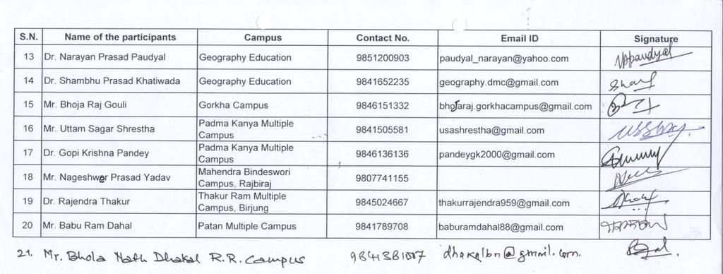
11 Annex 2. List of Participants and Attendance 10


12 11


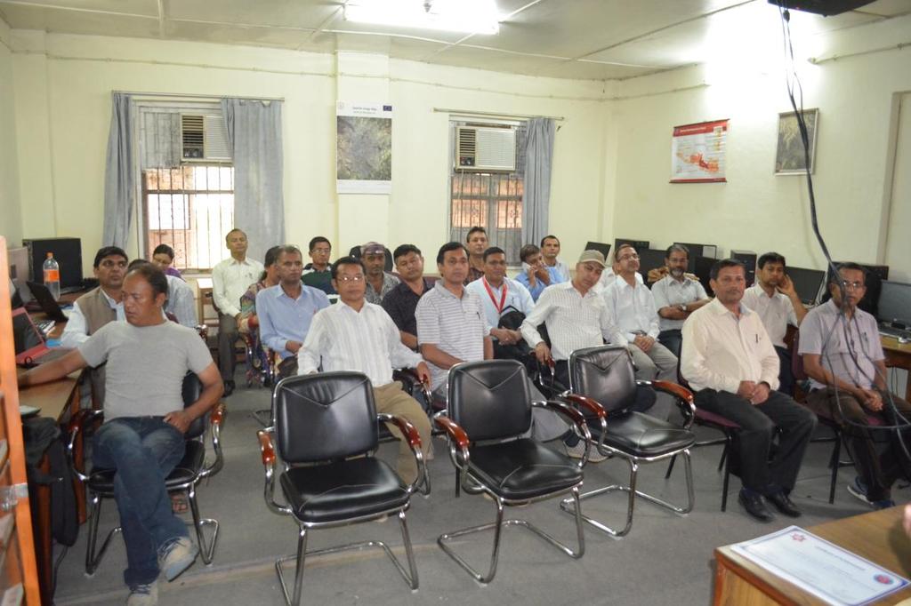
13 Annex 3. Glimpses of Training Program 12


14 13


15 14


16 15


17 16


18 17


19 18


20 19


21 20

22 21


23 22


24 23


25 24


26 25

27 Annex 4. Training Certificate 26
28 Annex 5. Evaluation Form Hands-on Laboratory Training Geographic Information System (GIS) and Remote Sensing (RS) for Geography Teachers Teaching in Bachelor level Campuses of Nepal Central Department of Geography, CDG Tribhuvan University 27 June - 01 July, 2017 (13 17 Asadh, 2074) Training Evaluation Sheet by Participants Aspects of Training Adequate (A) Inadequate (IN) Explanation Suggestion for improvement Time Duration Course Content Logistic Support Resource Person Training Materials If any relevant issues What was your expectation form the training? Whether training fulfill your expectation or not. Yes/No, if no give your reason 27
29 28
 UNIVERSITY GRANTS COMMISSION Sanothimi, Bhaktapur, Nepal RT-2 APLLICATION FOR CONDUCTING LABORATORY TRAINING (Advanced Laboratory Hands-On")
30 Annex 6. Proposal Submitted to the University Grants Commission Appendix 4.10: Application Form for Laboratory Training (Category 2) UNIVERSITY GRANTS COMMISSION Sanothimi, Bhaktapur, Nepal RT-2 APLLICATION FOR CONDUCTING LABORATORY TRAINING (Advanced Laboratory Hands-On Training) A. Organizing Institution (Host Laboratory) A1. Name of Institution: Central Department of Geography, Tribhuvan University A3. Mailing Address: Central Department of Geography, Tribhuvan University Kirtipur, Kathmandu, Nepal Po Box: 8613, Kathmandu A5. Head of the Institution: Name: Narendra Raj Khanal, PhD Position: Professor & Head Phone: Mobile: A7. Faculty Members/ Laboratory Experts A8. Previous Training Programs Conducted A2. Affiliated University (if any) A4. Contact: Mr. Gyanu Raja Maharjan, Head Office Assistant, Phone: Website: A6. Focal Person: Name: Umesh Kumar Mandal Position: Professor Phone: Mobile: Education Full Time Part Time PhD with Postdoc PhD 3 MPhil Masters with Thesis 4 Masters without Thesis Training Program Application of Geographic Information System (GIS) forclimate Risk managementfor CDRMP/UNDP district officers GIS and RS Training on Service Location Planning and Road development for Road Department engineers. GIS and RS Training on Service Location Planning for DoLIDARofficers No of Participants Date September, 2015 September, March, 2003 GIS and RS Training on Locational Planning 30 September, 29
31 at District Level for LGP/PDDP/UNDP district officers 2002 B. Facilities Available at the Laboratory B1. Laboratory (Space, Training Capacity): Remote Sensing/ Geographic Information System (RS/GIS) laboratory 23 fully equipped latest desktop computer with full RS/GIS software, other related programs and power backup B2. Equipments: Desktop and Laptop computers, GPS, Ground Surveying equipments (Theodolite etc), printers projectors, drawing instruments. Soil testing equipments (UV/VIS spectrophotometer etc.) B3. Software: RS/GIS software - ARCGIS, ARCInfo, ERDAS Imagine, ILWIS, IDRISI, ALDUS Freehand SPSS, other documentation and presentation programs B4. Reagents, Consumables: Printer color cartridges, etc B5. Lecture Facility (Projector, Printer etc) Multimedia, LCD Projector and screen, LCD TV Screen, Color printers, Laser printers, scanner, photocopy machine etc. C. Information About the Training C1. Full Title of the Program Geographic Information System (GIS) and Remote Sensing (RS) Trainingfor Geography Teachers Teaching in Bachelor level Campuses of Nepal C2. Duration (Days) 5 days (35 working hours) C3. Individual Sessions (add rows to add more sessions) Title of the Session Duration Venue Trainer 1. Opening Detailed CDG Lab Umesh Kumar GIS Concepts and RS Concept in Mandal, Detailed ShovaShresta, GPS and Using GPS (theory and practical) Training Chhabi Lala Chidi, program Sher Bahadur 2. GIS: Introduction to ArcGlS (Demo and Basic hands on) Gurung, Guest lectures 3. RS: Introduction to ILWIS (Demo and Basic hands on) 4. RS: Image Enhancement/Digital Image Processing 5. GIS: Data Processing, Exploring Resource data 6. Feature Extraction, Image Interpretation and Classification 7. GIS: Data Analysis 30
32 8. Designing and Preparing Maps, Hands on Practical 9. Map Preparation, Exporting Maps to report 10. Certificate Distribution and closing D. Participants (Number and Selection) D1. Faculty Members D2. PhD Candidates 20 Includes 3 PhD Candidates among those 20 D3. Masters/MPhil Students D4. Bachelors Students D5. Selection of Participants (describe Selection Criteria and Priority) Faculty members teaching Bachelor level geography in different TU campuses, TU affiliated campuses and community campuses. E. Plan of Action (Proposal) (8-10 pages) Use the following format 1. Purpose of the Program 2. Relevance of the Program 3. Organizing Committee 4. Tentative Schedule 5. Potential Participants 6. Selection Criteria and Priority 7. Major Method and Technology used in the Training 8. Laboratory Facilities 9. Detail of Training Sessions 10. Detailed Budget 11. Administrative and Logistic Support 12. CVs of Proposed Trainers 13. Acceptance Letters from the Proposed Trainers F. Co-Sponsor (if any) F1. Name of Co-Sponsor None F2. Contribution by Co-Sponsor G. Cost G1. Estimated Total Cost G2. Requested Funding from the UGC 31
33 NRs. 1,86, (One hundred eightysix thousand and four hundred Nepalese rupees only ) NRs. 1,76, (One hundred seventysix thousand and four hundred Nepalese rupees only ) H. Document Checklist H1. Before the Program (Indicate by ) H2. After the Program (submit later) 1. Completed Application Form 1. A Cover Letter signed by the Organizer 2. Plan of Action (Proposal) 2. A Narrative Report of the Program 3. CVs of Laboratory Instructors 3. A Copy of the Certificate Distributed 4. Acceptance Letters from the Instructors 4. A Copy of Daily Attendance 5. Program Brochure (if any) 5. Evaluation by Participants 6. Document Related to Participants 6. Financial Report 7. Photographs I. Undertaking by the Applicant I hereby declare that the above statement is true to the best of my knowledge and belief, and that I understand it is made for use as evidence in pertaining procedure and is subject to penalty for false statement and deception. The penalty may include refunding of the full amount disbursed in connection with this award and other individual and institutional restrictions for future support. Signature Name of the Head of Institution: Dr.Narendra Raj Khanal Position: Head and Professor Institution: Central Department of Geography Address: Kirtipur, Kathmandu Date: 19 February 2017 Official Seal 32
No. of Days. Building 3D cities Using Esri City Engine ,859. Creating & Analyzing Surfaces Using ArcGIS Spatial Analyst 1 7 3,139
 Q3 What s New? Creating and Editing Data with ArcGIS Pro Editing and Maintaining Parcels Using ArcGIS Spatial Analysis Using ArcGIS Pro User Workflows for ArcGIS Online Organizations Q3-2018 ArcGIS Desktop
No. of Days. ArcGIS 3: Performing Analysis ,431. Building 3D cities Using Esri City Engine ,859
 What s New? Creating Story Maps with ArcGIS Field Data Collection and Management Using ArcGIS Get Started with Insights for ArcGIS Introduction to GIS Using ArcGIS & ArcGIS Pro: Essential Workflow Migrating
No. of Days. ArcGIS Pro for GIS Professionals ,431. Building 3D cities Using Esri City Engine ,859
 What s New? Creating Story Maps with ArcGIS Field Data Collection and Management Using ArcGIS Get Started with Insights for ArcGIS Introduction to GIS Using ArcGIS & ArcGIS Pro: Essential Workflow Migrating
Regional Centre for Mapping of Resources for Development (RCMRD), Nairobi, Kenya
, Nairobi, Kenya") Regional Centre for Mapping of Resources for Development (RCMRD), Nairobi, Kenya Introduction to GIS (2 weeks: 10 days) Intakes: 8 th January, 6 th February, 5th March, 3 rd. April 9 th, May 7 th, June
Regional Centre for Mapping of Resources for Development (RCMRD), Nairobi, Kenya Introduction to GIS (2 weeks: 10 days) Intakes: 8 th January, 6 th February, 5th March, 3 rd. April 9 th, May 7 th, June
CERTIFICATE COURSE IN GEO-INFORMATICS 1 (GGFGIS7) 2016
 2016") UNIVERSITY OF JOHANNESBURG DEPARTMENT OF GEOGRAPHY, ENVIRONMENTAL MANAGEMENT AND ENERGY STUDIES CERTIFICATE COURSE IN GEO-INFORMATICS 1 (GGFGIS7) 2016 THE COURSE: The Geo-Informatics 1 course is an introduction
UNIVERSITY OF JOHANNESBURG DEPARTMENT OF GEOGRAPHY, ENVIRONMENTAL MANAGEMENT AND ENERGY STUDIES CERTIFICATE COURSE IN GEO-INFORMATICS 1 (GGFGIS7) 2016 THE COURSE: The Geo-Informatics 1 course is an introduction
GIS certificate; 24th 28th September and 3rd 7th December University of Venda
 ;, TARGET Delegates; Town planners. Geologist, Hydrologist, Hydro-Geologists Botanists Conservationists Land Surveyors, Educators, Researchers, Undergraduate and post-graduate students, companies, Local
Regional Centre for Mapping of Resources for Development (RCMRD), Nairobi, Kenya. Introduction GIS ( 2 weeks: 10 days)
, Nairobi, Kenya. Introduction GIS ( 2 weeks: 10 days)") Regional Centre for Mapping of Resources for Development (RCMRD), Nairobi, Kenya Introduction GIS ( 2 weeks: 10 days) Intakes: 8 th Jan, 6 th Feb,5 th March, 3 rd April 9 th, May 7 th, June 4 th, July
Regional Centre for Mapping of Resources for Development (RCMRD), Nairobi, Kenya Introduction GIS ( 2 weeks: 10 days) Intakes: 8 th Jan, 6 th Feb,5 th March, 3 rd April 9 th, May 7 th, June 4 th, July
Lab Assistant: Kathy Tang Office: SSC 2208 Phone: ext
 The University of Western Ontario Department of Geography GEOGRAPHY 9110B: Introduction to Geographic Information Systems Lecture: Thursday 11:30 1:30pm, SSC #1004 Lab: Thursday 2:30 4:30pm, SSC #1316A
ARCGIS TRAINING AT KU GIS LABS: INTRODUCTION TO GIS: EXPLORING ARCCATALOG AND ARCGIS TOOLS
 PHASE 1_3 rd SESSION ARCGIS TRAINING AT KU GIS LABS: INTRODUCTION TO GIS: EXPLORING ARCCATALOG AND ARCGIS TOOLS 3 rd SESSION REPORT: 25 TH -27 TH JUNE 2014 SCHOOL OF ENVIRONMENTAL STUDIES COMPUTER LAB
Regional Centre for Mapping of Resources for Development (RCMRD), Nairobi, Kenya
, Nairobi, Kenya") Regional Centre for Mapping of Resources for Development (RCMRD), Nairobi, Kenya Introduction GIS ( 2 weeks: 10 days) Intakes: 7 th Jan, 4 th Feb,4 th March, 1 st April 6 th May, 3 rd June, 1 st July,
Regional Centre for Mapping of Resources for Development (RCMRD), Nairobi, Kenya Introduction GIS ( 2 weeks: 10 days) Intakes: 7 th Jan, 4 th Feb,4 th March, 1 st April 6 th May, 3 rd June, 1 st July,
Introduction to GIS (GEOG 401) Spring 2014, 3 credit hours
 Spring 2014, 3 credit hours") Introduction to GIS (GEOG 401) Spring 2014, 3 credit hours Instructors: Guangxing Wang, Ph.D. Email: gxwang@siu.edu Phone: (618) 453-6017 Office: 4442 Faner Hall Office hours: M& W&F 9:00am-11:00am or
Introduction to GIS (GEOG 401) Spring 2014, 3 credit hours Instructors: Guangxing Wang, Ph.D. Email: gxwang@siu.edu Phone: (618) 453-6017 Office: 4442 Faner Hall Office hours: M& W&F 9:00am-11:00am or
GEOG 508 GEOGRAPHIC INFORMATION SYSTEMS I KANSAS STATE UNIVERSITY DEPARTMENT OF GEOGRAPHY FALL SEMESTER, 2002
 GEOG 508 GEOGRAPHIC INFORMATION SYSTEMS I KANSAS STATE UNIVERSITY DEPARTMENT OF GEOGRAPHY FALL SEMESTER, 2002 Course Reference #: 13210 Meeting Time: TU 2:05pm - 3:20 pm Meeting Place: Ackert 221 Remote
SOUTH DAKOTA BOARD OF REGENTS. Academic and Student Affairs ******************************************************************************
 SOUTH DAKOTA BOARD OF REGENTS Academic and Student Affairs AGENDA ITEM: 7 C (4) DATE: June 28-30, 2016 ****************************************************************************** SUBJECT: New Minor:
2.1.9 Expansion of Instructional GIS Lab Page 1 of 6. Fiscal Year 2002 Years Following Fiscal Year 2002 $61, $23,625.00
 2.1.9 Expansion of Instructional GIS Lab Page 1 of 6 Proposal for the Use of the FY2002 Technology Fee Submitting Organization: Anthropology and Geography Contact Person: Zhi-Yong Yin Email: gegzyy@panther.gsu.edu
Sino-Nepal Joint Research Centre for Geography
 Sino-Nepal Joint Research Centre for Geography Central Department of Geography, Tribhuvan University, Kathmandu, Nepal Institute of Mountain Hazards and Environment, Chinese Academy of Sciences, Chengdu,
Regional Centre for Mapping of Resources for Development (RCMRD), Nairobi, Kenya. Introduction GIS (2 weeks: 10 days)
, Nairobi, Kenya. Introduction GIS (2 weeks: 10 days)") Regional Centre for Mapping of Resources for Development (RCMRD), Nairobi, Kenya Introduction GIS (: 10 days) Intake Dates: 9 th Jan, 6 th Feb, 6 th Mar, 3 rd April, 8 th May, 5 th June, 3 rd July, 2017
Regional Centre for Mapping of Resources for Development (RCMRD), Nairobi, Kenya Introduction GIS (: 10 days) Intake Dates: 9 th Jan, 6 th Feb, 6 th Mar, 3 rd April, 8 th May, 5 th June, 3 rd July, 2017
ENVIRONMENT AND NATURAL RESOURCES 3700 Introduction to Spatial Information for Environment and Natural Resources. (2 Credit Hours) Semester Syllabus
 Semester Syllabus") ENVIRONMENT AND NATURAL RESOURCES 3700 Introduction to Spatial Information for Environment and Natural Resources COURSE INSTRUCTOR: Dr. Kris Jaeger Assistant Professor 359 Kottman Hall (Mondays and Tuesdays)
ENVIRONMENT AND NATURAL RESOURCES 3700 Introduction to Spatial Information for Environment and Natural Resources COURSE INSTRUCTOR: Dr. Kris Jaeger Assistant Professor 359 Kottman Hall (Mondays and Tuesdays)
Diffusion of GIS in Public Policy Doctoral Program
 Diffusion of GIS in Public Policy Doctoral Program By Fulbert Namwamba PhD Southern University This presentation demonstrate how GIS was introduced in the Public Policy Doctoral Program at Southern University,
AGRY 545/ASM 591R. Remote Sensing of Land Resources. Fall Semester Course Syllabus
 AGRY 545/ASM 591R Remote Sensing of Land Resources Fall Semester 2005 Course Syllabus Agronomy 545/ASM 591R is a graduate level course designed to teach students how to analyze and interpret remotely sensed
CAS GE 365 Introduction to Geographical Information Systems. The Applications of GIS are endless
 Spring 2007 CAS GE 365 Introduction to Geographical Information Systems Boston University Department of Geography and Environment The Applications of GIS are endless images from www.esri.com CAS GE 365
INTEGRATING GEOSPATIAL PERSPECTIVES IN THE ANTHROPOLOGY CURRICULUM AT THE UNIVERSITY OF NEW MEXICO (UNM)
") INTEGRATING GEOSPATIAL PERSPECTIVES IN THE ANTHROPOLOGY CURRICULUM AT THE UNIVERSITY OF NEW MEXICO (UNM) VERONICA ARIAS HEATHER RICHARDS JUDITH VAN DER ELST DEPARTMENT OF ANTHROPOLOGY MARCH 2005 INTEGRATING
INTEGRATING GEOSPATIAL PERSPECTIVES IN THE ANTHROPOLOGY CURRICULUM AT THE UNIVERSITY OF NEW MEXICO (UNM) VERONICA ARIAS HEATHER RICHARDS JUDITH VAN DER ELST DEPARTMENT OF ANTHROPOLOGY MARCH 2005 INTEGRATING
HGP 470 GIS and Advanced Cartography for Social Science
 HGP 470 GIS and Advanced Cartography for Social Science Winter 2014 Instructor: Office: Tory 3-115 Telephone: 780-248-5758 E-mail: vukicevi@ualberta.ca Office hours: By appointment LECTURES AND LABS Lectures/Labs:
Geographic Systems and Analysis
 Geographic Systems and Analysis New York University Robert F. Wagner Graduate School of Public Service Instructor Stephanie Rosoff Contact: stephanie.rosoff@nyu.edu Office hours: Mondays by appointment
GTECH 380/722 Analytical and Computer Cartography Hunter College, CUNY Department of Geography
 GTECH 380/722 Analytical and Computer Cartography Hunter College, CUNY Department of Geography Fall 2014 Mondays 5:35PM to 9:15PM Instructor: Doug Williamson, PhD Email: Douglas.Williamson@hunter.cuny.edu
Introduction to Coastal GIS
 Introduction to Coastal GIS Event was held on Tues, 1/8/13 - Thurs, 1/10/13 Time: 9:00 am to 5:00 pm Location: Roger Williams University, Bristol, RI Audience: The intended audiences for this course are
Call for Hosting the 16 th World (ISSP) Congress in Sport Psychology in 2025
 Congress in Sport Psychology in 2025") Call for Hosting the 16 th World (ISSP) Congress in Sport Psychology in 2025 The International Society of Sport Psychology (ISSP) encourages groups and organizations to host the 16 th World Congress in
Call for Hosting the 16 th World (ISSP) Congress in Sport Psychology in 2025 The International Society of Sport Psychology (ISSP) encourages groups and organizations to host the 16 th World Congress in
FOSS4G 2010 presented by OSGeo Proposal
 FOSS4G 2010 presented by OSGeo Proposal About OSGeo China The China Chapter of OSGeo is formed by Chinese Active Users of Open Source Geospatial Software, hosted by National Remote Sensing Center of China
ESRI educational site license in Bahir Dar University. Tegegn Molla Abebe Mengaw Geospatial Data and Technology Center, BDU
 ESRI educational site license in Bahir Dar University Tegegn Molla Abebe Mengaw Geospatial Data and Technology Center, BDU September, 2016 Mission, Vision Purpose and Values of the GDTC Mission of GDTC
Short Term Course GEOINFORMATION SCIENCE AND TECHNOLOGY REMOTE SENSING, GPS, & GIS APPLICATIONS. Duration: 20 Weeks Two Batches in an year
 Short Term Course on GEOINFORMATION SCIENCE AND TECHNOLOGY REMOTE SENSING, GPS, & GIS APPLICATIONS Duration: 20 Weeks Two Batches in an year Information Brochure Dr. R. Satheesh Centre for Remote Sensing
Curriculum Vitae. Dr. Danqing (Dana) Xiao. Ph.D. in Department of Geography, University of California Santa Barbara.
 Xiao. Ph.D. in Department of Geography, University of California Santa Barbara.") Curriculum Vitae Dr. Danqing (Dana) Xiao Personal Information Assistant Professor Department of Environmental, Geographical, and Geological Sciences (EGGS), Bloomsburg University of Pennsylvania Research
Curriculum Vitae Dr. Danqing (Dana) Xiao Personal Information Assistant Professor Department of Environmental, Geographical, and Geological Sciences (EGGS), Bloomsburg University of Pennsylvania Research
PHASE 1_7 TH SESSION ARCGIS TRAINING AT KU GIS LABS: INTRODUCTION TO GIS: EXPLORING ARCCATALOG AND ARCGIS TOOLS
 PHASE 1_7 TH SESSION ARCGIS TRAINING AT KU GIS LABS: INTRODUCTION TO GIS: EXPLORING ARCCATALOG AND ARCGIS TOOLS 7 TH SESSION REPORT: 10 TH - 12 TH SEPTEMBER 2014 SCHOOL OF ENGINEERING AND TECHNOLOGY COMPUTER
Favorable potential zone map using Remote sensing and GIS
 Favorable potential zone map using Remote sensing and GIS M. Devarajan & S.Mohan GIS Cell, Hydrogeology Wing Tamilnadu Water Supply and Drainage Board, Chennai Abstract: TWAD Board is shouldering the responsibility
Course Outline. Code: TPP103 Title: Chemistry
 Course Outline Code: TPP103 Title: Chemistry Faculty of: Science, Health, Education and Engineering Teaching Session: Session 8 Year: 2018 Course Coordinator: Michelle Parks Tel: 545655547 Email: MParks@usc.edu.au
GIS = Geographic Information Systems;
 What is GIS GIS = Geographic Information Systems; What Information are we talking about? Information about anything that has a place (e.g. locations of features, address of people) on Earth s surface,
Introduction to Coastal GIS
 Held on Tues, 1/8/13 through Thurs, 1/10/13 Location: Roger Williams University, Bristol, RI Audience: The intended audiences for this course are federal and state personnel, municipal staff and officials,
ARCGIS TRAINING AT KU GIS LABS: INTRODUCTION TO GIS: EXPLORING ARCCATALOG AND ARCGIS TOOLS
 PHASE 1_4 th SESSION ARCGIS TRAINING AT KU GIS LABS: INTRODUCTION TO GIS: EXPLORING ARCCATALOG AND ARCGIS TOOLS 4 th SESSION REPORT: 30 TH JUNE - 2 ND JULY SCHOOL OF ENVIRONMENTAL STUDIES COMPUTER LAB
NOTE BY THE TECHNICAL SECRETARIAT ESTABLISHMENT OF A DATABASE OF EXPERTISE ON PEACEFUL USES OF CHEMISTRY
 OPCW Technical Secretariat 30 August 2016 ENGLISH only NOTE BY THE TECHNICAL SECRETARIAT ESTABLISHMENT OF A DATABASE OF EXPERTISE ON PEACEFUL USES OF CHEMISTRY 1. At its Sixteenth Session, the Conference
Introduction to Geographic Information Systems
 Geog 58 Introduction to Geographic Information Systems, Fall, 2003 Page 1/8 Geography 58 Introduction to Geographic Information Systems Instructor: Lecture Hours: Lab Hours: X-period: Office Hours: Classroom:
USING LANDSAT IN A GIS WORLD
 USING LANDSAT IN A GIS WORLD RACHEL MK HEADLEY; PHD, PMP STEM LIAISON, ACADEMIC AFFAIRS BLACK HILLS STATE UNIVERSITY This material is based upon work supported by the National Science Foundation under
GEOGRAPHIC INFORMATION SYSTEM ANALYST I GEOGRAPHIC INFORMATION SYSTEM ANALYST II
 CITY OF ROSEVILLE GEOGRAPHIC INFORMATION SYSTEM ANALYST I GEOGRAPHIC INFORMATION SYSTEM ANALYST II DEFINITION To perform professional level work in Geographic Information Systems (GIS) management and analysis;
Request for Empanelment
 Request for Empanelment (Empanelment is method/procedure/way to seek technical & financial or financial quotation from eligible firm/organization/academic institute to short list eligible contender for
GTECH 380/722 Analytical and Computer Cartography Hunter College, CUNY Department of Geography
 GTECH 380/722 Analytical and Computer Cartography Hunter College, CUNY Department of Geography Spring 2010 Wednesdays 5:35PM to 9:15PM Instructor: Doug Williamson, PhD Email: Douglas.Williamson@hunter.cuny.edu
(C.V) Personal Data. Ali Mahmoud Mahdi Gahlan. PLACE OF BIRTH: Nag Hammadi city, Qena, Egypt. English: (Very Good)
 Personal Data. Ali Mahmoud Mahdi Gahlan. PLACE OF BIRTH: Nag Hammadi city, Qena, Egypt. English: (Very Good)") (C.V) Personal Data NAME: NATIONALITY: Ali Mahmoud Mahdi Gahlan Egyptian DATE OF BIRTH: 3 March 1981 PLACE OF BIRTH: Nag Hammadi city, Qena, Egypt MARITAL STATUS: Married LANGUAGES: Arabic: native language
(C.V) Personal Data NAME: NATIONALITY: Ali Mahmoud Mahdi Gahlan Egyptian DATE OF BIRTH: 3 March 1981 PLACE OF BIRTH: Nag Hammadi city, Qena, Egypt MARITAL STATUS: Married LANGUAGES: Arabic: native language
Department of Geography
 Department of Geography University School of Sciences, Gujarat University, Navrangpura, Ahmedabad 380009. Phone : +91-79-27912832 Director Head I/C : Prof. M. V. RAO : MR. MAHESHKUMAR K. PATEL Brief History
Teaching Field: Geology Date: 10/16/2015 Higher Learning Commission (HLC) Faculty Qualifications for Hiring
 Faculty Qualifications for Hiring") Teaching Field: Geology Date: 10/16/2015 Higher Learning Commission (HLC) Faculty Qualifications for Hiring The Geology Instructional Council of the Maricopa County Community College District is firmly
Teaching Field: Geology Date: 10/16/2015 Higher Learning Commission (HLC) Faculty Qualifications for Hiring The Geology Instructional Council of the Maricopa County Community College District is firmly
Cartographic Division Proposal
 Cartographic Division Proposal Steve Henderson, Public Works Engineer Background The City of Gulf Shores is expected to purchase or lease additional buildings across the street from City Hall to accommodate
Oakland County Parks and Recreation GIS Implementation Plan
 Oakland County Parks and Recreation GIS Implementation Plan TABLE OF CONTENTS 1.0 Introduction... 3 1.1 What is GIS? 1.2 Purpose 1.3 Background 2.0 Software... 4 2.1 ArcGIS Desktop 2.2 ArcGIS Explorer
GEOGRAPHY MA, ASSESSMENT REPORT AY
 GEOGRAPHY MA, ASSESSMENT REPORT AY2012-2013 Programs: Geography MA Options Department: GSHAA Assessment Instruments and Student Outcomes This is an assessment report on three MA options in Geography in
CAA 1 of 30. To: OAA Date: 6/14/2010. Cover Letter for Proposals from the Department of Geography
 1 of 30 To: OAA Date: 6/14/2010 Cover Letter for Proposals from the Department of Geography This is the transmittal cover letter to the Office of Academic Affairs that reflects the efforts by the Department
SCHOOL OF ENGINEERING AND TECHNOLOGY COMPUTER LAB
 PHASE 1_6 TH SESSION ARCGIS TRAINING AT KU GIS LABS: INTRODUCTION TO GIS: EXPLORING ARCCATALOG AND ARCGIS TOOLS 6 TH SESSION REPORT: 3 RD -5 TH SEPTEMBER 2014 SCHOOL OF ENGINEERING AND TECHNOLOGY COMPUTER
Educational Qualification No ( No of Positions) 01. Geographic
 01. Geographic") ICZMP, State Project Management Unit-Orissa Plot # 108,Unit VII, Suryanagar,Bhubaneswar 751 003 ICZMP invites applications from eligible candidates for filling up of posts as mentioned below under the
ICZMP, State Project Management Unit-Orissa Plot # 108,Unit VII, Suryanagar,Bhubaneswar 751 003 ICZMP invites applications from eligible candidates for filling up of posts as mentioned below under the
Angelina College Science and Mathematics Chemistry 1105 Introductory Chemistry Internet General Syllabus
 I. BASIC COURSE INFORMATION: Angelina College Science and Mathematics Chemistry 1105 Introductory Chemistry Internet General Syllabus A. Course Description: 1. Basic laboratory experiments supporting theoretical
JOB DESCRI PTI ON. GIS Administrator
 JOB DESCRI PTI ON JOB GRADE: GS-0 Cla ss Code : Office - 8 8 0 DEPARTMENT: 2 0 - FLSA: EXEMPT JOB NO: 6-0 9-2 7 SALARY: To Be De t e rm in e d Job description statements are intended to describe the general
WHAT YOU WILL LEARN TODAY
 WHAT YOU WILL LEARN TODAY Overview of the new QGIS Academy Curriculum Background on curriculum development Curriculum alignment with national standards Description of the five GIS courses Details of the
Geog418: Introduction to GIS Fall 2011 Course Syllabus. Textbook: Introduction to Geographic Information Systems edited by Chang (6th ed.
 Geog418: Introduction to GIS Fall 2011 Course Syllabus AH 1320 3:30 4:45 p.m.tr Instructor: Dr. Shunfu Hu Office: AH1413 Telephone 650-2281 Office hours: 10:00 11:00 a.m. TR or by appointment (shu@siue.edu)
Science Academy s Lecture Workshop on Spectroscopic Techniques and Applications in Material Characterization-(STAMC-2016)
") Science Academy s Lecture Workshop on Spectroscopic Techniques and Applications in Material Characterization-(STAMC-2016) Aim of the work shop: To enhance the knowledge of the students, teachers and research
Science Academy s Lecture Workshop on Spectroscopic Techniques and Applications in Material Characterization-(STAMC-2016) Aim of the work shop: To enhance the knowledge of the students, teachers and research
STATISTICAL AND THERMAL PHYSICS
 Phys 362 Spring 2015 STATISTICAL AND THERMAL PHYSICS Phys 362 Spring 2015 Instructor: Office: Professor David Collins WS 228B Phone: 248-1787 email: Office Hours: dacollin@coloradomesa.edu M 9 10 am, 11
CHAPTER 22 GEOGRAPHIC INFORMATION SYSTEMS
 CHAPTER 22 GEOGRAPHIC INFORMATION SYSTEMS PURPOSE: This chapter establishes the administration and use of to improve the quality and accessibility of Department s spatial information and support graphical
FIRE DEPARMENT SANTA CLARA COUNTY
 DEFINITION FIRE DEPARMENT SANTA CLARA COUNTY GEOGRAPHIC INFORMATION SYSTEM (GIS) ANALYST Under the direction of the Information Technology Officer, the GIS Analyst provides geo-spatial strategic planning,
Tuesday 6:30 9:30 (First/Last classes) Home Phone: SYLLABUS. I. Focus of Course
 Home Phone: SYLLABUS. I. Focus of Course") PSC 560-G Stephen Sherman GIS in Public Administration Political Science Dept. Summer, First Session, 2014 Work Phone: 373-4503 (Tue & Thur) Tuesday 6:30 9:30 (First/Last classes) Home Phone: 375-5328
PSC 560-G Stephen Sherman GIS in Public Administration Political Science Dept. Summer, First Session, 2014 Work Phone: 373-4503 (Tue & Thur) Tuesday 6:30 9:30 (First/Last classes) Home Phone: 375-5328
Proposal for Revision to the Geographic Information Systems (GIS) Academic Certificate Community College of Philadelphia.
 Academic Certificate Community College of Philadelphia.") Proposal for Revision to the Geographic Information Systems (GIS) Academic Certificate Community College of Philadelphia February 24, 2010 Kathy Smith Chair, Social Science Contributors Christopher Murphy
Proposal for Revision to the Geographic Information Systems (GIS) Academic Certificate Community College of Philadelphia February 24, 2010 Kathy Smith Chair, Social Science Contributors Christopher Murphy
Licensed Science Officer Benchmark
 POSITION EVALUATION RATIONALE POSITION TITLE MINISTRY AND DIVISION Energy, Mines and Petroleum Resources: Geology Division BRANCH AND SECTION Mineral Resources Branch, Applied Geology Section UNIT OR PROGRAM
HGP 470 GIS and Advanced Cartography in Social Science
 HGP 470 GIS and Advanced Cartography in Social Science Fall 2012 Instructor: Dr Sinisa J. Vukicevic Office: Tory 3-115 Telephone: 780-248-5758 E-mail: vukicevi@ualberta.ca Office hours: Wednesday 10:00
Course overview. Grading and Evaluation. Final project. Where and When? Welcome to REM402 Applied Spatial Analysis in Natural Resources.
 Welcome to REM402 Applied Spatial Analysis in Natural Resources Eva Strand, University of Idaho Map of the Pacific Northwest from http://www.or.blm.gov/gis/ Where and When? Lectures Monday & Wednesday
Economic and Social Council
 United Nations Economic and Social Council Distr.: General 23 May 2012 Original: English E/CONF.101/100 Tenth United Nations Conference on the Standardization of Geographical Names New York, 31 July 9
The Activities Undertaken by the Central Department of Geography, Tribhuvan University:
 The Geographical Journal of Nepal, Vol. 8-9, 2010-2011: 93-99 The Activities Undertaken by the Central Department of Geography, Tribhuvan University: 2010-2011 Introduction Pushkar K Pradhan, PhD Professor
GIS Applications on Environmental Education in Taiwan
 GIS Applications on Environmental Education in Taiwan Track: Education Authors: Yu-Chen Lai, Mei-Ling Yeh, Tien-Yin Chou Abstract GIS is a perfect vehicle to deliver environmental knowledge and spatial
https://sites.google.com/a/pdx.edu/gis-2-applications/home
 Page 1 of 5 GIS 2: APPLICATIONS Search this site GEOG 492/592: GIS 2 Syllabus Academic Guidelines Rubrics Presentation Rubric Project Poster Project Proposal Syllabus (PDF) Sitemap GEOG 492/592: GIS 2
COURSE OUTLINE GEOL204 MINING COMPUTING 3 CREDITS
 COURSE OUTLINE GEOL204 MINING COMPUTING 3 CREDITS PREPARED BY: Joel Cubley, Instructor DATE: June 1, 2018 APPROVED BY: Margaret Dumkee, Dean DATE: June 1, 2018 APPROVED BY ACADEMIC COUNCIL: May 2014 GEOL204
Geography (GEOG) Courses
 Courses") Geography (GEOG) 1 Geography (GEOG) Courses GEOG 100. Introduction to Human Geography. 4 (GE=D4) Introduction to the global patterns and dynamics of such human activities as population growth and movements,
Geography (GEOG) 1 Geography (GEOG) Courses GEOG 100. Introduction to Human Geography. 4 (GE=D4) Introduction to the global patterns and dynamics of such human activities as population growth and movements,
Teaching GIS Technology at UW-Superior. Volume 9, Number 8: May 23, 2003
 Teaching GIS Technology at UW-Superior Volume 9, Number 8: May 23, 2003 William Bajjali University of Wisconsin, department of Biology and Earth Science, Superior, WI 54880 Abstract As educators, it is
El Camino College/ Compton Center. Dr. Jane Harmon, Dean. Geology Department. Program Review. Spring Prepared by Leonard Clark
 El Camino College/ Compton Center Dr. Jane Harmon, Dean Geology Department Program Review Spring 2009 Prepared by Leonard Clark Overview of Department The geology department at the El Camino College (ECC)
LOS ANGELES UNIFIED SCHOOL DISTRICT REFERENCE GUIDE
 REFERENCE GUIDE TITLE: NUMBER: ISSUER: Chemical Safety Coordinators REF-1563.3 Yi Hwa Kim, Interim Director Enrique G. Boull t Chief Operating Officer ROUTING All Secondary Schools All Middle Schools All
INTERNATIONAL TRAINING COURSE ON THE APPLICATION OF METEOROLOGICAL SATELLITE PRODUCTS 20 June to 1 July 2016, Beijing, China ENROLMENT INFORMATION
 ETR/CRS-316, ANNEX 1 INTERNATIONAL TRAINING COURSE ON THE APPLICATION OF METEOROLOGICAL SATELLITE PRODUCTS 20 June to 1 July 2016, Beijing, China ENROLMENT INFORMATION The International Training Course
Techniques for Science Teachers: Using GIS in Science Classrooms.
 Techniques for Science Teachers: Using GIS in Science Classrooms. After ESRI, 2008 GIS A Geographic Information System A collection of computer hardware, software, and geographic data used together for
The University of Jordan. Accreditation & Quality Assurance Center. Course Name: Structural Geology COURSE Syllabus
 The University of Jordan Accreditation & Quality Assurance Center COURSE Syllabus Course Name: Structural Geology 0305341 1 Course title Structural Geology 2 Course number 0305341 3 Credit hours (theory,
Licensed Science Officer Benchmark
 POSITION EVALUATION RATIONALE POSITION TITLE Senior Project Geologist MINISTRY AND DIVISION Energy, Mines and Petroleum Resources: Geological Division BRANCH AND SECTION Mineral Resources UNIT OR PROGRAM
WHAT YOU WILL LEARN TODAY
 WHAT YOU WILL LEARN TODAY Overview of the new GeoAcademy Curriculum Background on curriculum development Curriculum alignment with national standards Description of the five GIS courses Details of the
The Chemists Online Self-study Award Scheme 2017
 Annex 7 The Chemists Online Self-study Award Scheme 2017 Aims / Objectives This is to invite secondary schools to participate in the captioned Award Scheme. Details 2. The Chemists Online Self-study Award
GEOGRAPHIC INFORMATION SYSTEM (GES203)
") GEOGRAPHIC INFORMATION SYSTEM (GES203) GIS Components Level 2:1 By: Mrs Mupfiga Presentation Layout Recap Learning Objectives Components of GIS GIS Data References Lecture Evaluation Learning Objectives
GEOGRAPHIC INFORMATION SYSTEM (GES203) GIS Components Level 2:1 By: Mrs Mupfiga Presentation Layout Recap Learning Objectives Components of GIS GIS Data References Lecture Evaluation Learning Objectives
DP Project Development Pvt. Ltd.
 Dear Sir/Madam, Greetings!!! Thanks for contacting DP Project Development for your training requirement. DP Project Development is leading professional training provider in GIS technologies and GIS application
Dr. Stephen J. Walsh Department of Geography, UNC-CH Fall, 2007 Monday 3:30-6:00 pm Saunders Hall Room 220. Introduction
 Geographic Information Systems Geography 491 Dr. Stephen J. Walsh Department of Geography, UNC-CH Fall, 2007 Monday 3:30-6:00 pm Saunders Hall Room 220 Introduction Organizations that have a planning,
Spatial Data Analysis with ArcGIS Desktop: From Basic to Advance
 Spatial Data Analysis with ArcGIS Desktop: From Basic to Advance 1. Course overview Modern environmental, energy as well as resource modeling and planning require huge amount of geographically located
Angelina College Science and Mathematics Chemistry 1305 Introductory Chemistry General Syllabus
 I. BASIC COURSE INFORMATION: Angelina College Science and Mathematics Chemistry 1305 Introductory Chemistry General Syllabus A. Course Description: Three hours credit. A basic presentation of chemistry.
Developing a Community Geographical Information System (GIS) in Rural India
 in Rural India") Developing a Community Geographical Information System (GIS) in Rural India Before rushing off and describing the unique challenges of developing a small scale GIS system India I better first describe
Developing a Community Geographical Information System (GIS) in Rural India Before rushing off and describing the unique challenges of developing a small scale GIS system India I better first describe
Learning Computer-Assisted Map Analysis
 Learning Computer-Assisted Map Analysis by Joseph K. Berry* Old-fashioned math and statistics can go a long way toward helping us understand GIS Note: This paper was first published as part of a three-part
Geospatial Analysis in Cultural Anthropology
 Eduardo Brondizio (ebrondiz@ufl.edu) Tracy Van Holt (tvanholt@ufl.edu) Geospatial Analysis in Cultural Anthropology Description and Objectives: This intensive course introduces different components of
Cooperation is the key, FIG can facilitate
 Cooperation is the key, FIG can facilitate Mikael Lilje Vice President 2017-2020 Head, Geodetic infrastructure, Swedish mapping, cadastral and land registration authority Presented at the GIS/RS Conference
International Training Course on Use of Meteorological Instruments, from 5 to 16 June 2014, Nanjing, China
 ~ ~ \ ~-. -- I ~ WMOOMM World Meteorological Organization Organisation meteorologique mondiale Secretariat 7 bis, avenue de Ia Paix - Case postale 2300 - CH 1211 Geneve 2- Suisse Tel.: +41 (0) 22 730 8111
1. Omit Human and Physical Geography electives (6 credits) 2. Add GEOG 677:Internet GIS (3 credits) 3. Add 3 credits to GEOG 797: Final Project
 2. Add GEOG 677:Internet GIS (3 credits) 3. Add 3 credits to GEOG 797: Final Project") The Department of Geography and the Office of Professional Studies propose to modify the Master of Professional Studies in Geospatial Information Sciences (GIS) as follows: 1. Omit Human and Physical Geography
The Department of Geography and the Office of Professional Studies propose to modify the Master of Professional Studies in Geospatial Information Sciences (GIS) as follows: 1. Omit Human and Physical Geography
Training Courses 2018
 Caribbean Institute for Meteorology and Hydrology The Caribbean Institute for Meteorology and Hydrology The Caribbean Institute for Meteorology and Hydrology is the regional Institution mandated to conduct
Geographic Information for Economic and Spatial Decisions
 !"#$!%& ''"(')* +"&'",, *+""-./0 Geographic Information for Economic and Spatial Decisions Objectives The master is aimed at creating skilled professionals in Geographic Information, qualified to work
GEOGRAPHIC INFORMATION SYSTEMS SPECIALIST 3 DEFINITION:
 Hunterdon County Department of Planning and Land Use Vacancy: Geographic Information Systems Specialist 3 Full Time: 40 Hours per Week Compensation: $42,000.00 per year GEOGRAPHIC INFORMATION SYSTEMS SPECIALIST
Capacity Building Activities at CRECTEALC. Ing. Jerjes Molina Blancas Professor and Developer.
 Capacity Building Activities at CRECTEALC Ing. Jerjes Molina Blancas Professor and Developer. Centro Regional de Enseñanza de Ciencia y Tecnología del Espacio para América Latina y el Caribe (CRECTEALC)
M.Sc. (Applied Geology) from Aligarh Muslim University, Aligarh, U.P. India, with First division (72%) in the year 2008.
 from Aligarh Muslim University, Aligarh, U.P. India, with First division (72%) in the year 2008.") CURRICULUM VITAE SAYEMA JAMAL OBJECTIVE To work in a self esteemed highly motivated, co-operative and competitive atmosphere that includes innovative ideas and a spirit of team work for my overall professional
CURRICULUM VITAE SAYEMA JAMAL OBJECTIVE To work in a self esteemed highly motivated, co-operative and competitive atmosphere that includes innovative ideas and a spirit of team work for my overall professional
Snowden Cartography 1 GEOG 315:001 Cartography Thursdays 4:00 6:30PM F375 Fall 2010 Dr. Snowden Course Description
 Snowden Cartography 1 www.drksnowden.com GEOG 315:001 Cartography Thursdays 4:00 6:30PM F375 Fall 2010 Dr. Snowden Course Description Principles and theory of basic map design, layout, and communication.
INDIAN INSTITUTE OF TROPICAL METEOROLOGY, PUNE Advertisement No. PER/ 09 /2010 Opportunities for Talented Young Scientists in Climate Science
 INDIAN INSTITUTE OF TROPICAL METEOROLOGY, PUNE411008 (An Autonomous Institute under Ministry of Earth Sciences, Government of India) Advertisement No. PER/ 09 /2010 Opportunities for Talented Young Scientists
ECONOMIC AND SOCIAL COUNCIL 13 July 2007
 UNITED NATIONS E/CONF.98/CRP.34 ECONOMIC AND SOCIAL COUNCIL 13 July 2007 Ninth United Nations Conference on the Standardization of Geographical Names New York, 21-30 August 2007 Item 17(b) of the provisional
Geography 1103: Spatial Thinking
 Geography 1103: Spatial Thinking Lecture: T\TH 8:00-9:15 am (McEniry 401) Lab: Wed 2:00-4:30 pm (McEniry 420) Instructor: Dr. Elizabeth C. Delmelle Email: edelmell@uncc.edu Office: McEniry 419 Phone: 704-687-5932
GIS Visualization: A Library s Pursuit Towards Creative and Innovative Research
 GIS Visualization: A Library s Pursuit Towards Creative and Innovative Research Justin B. Sorensen J. Willard Marriott Library University of Utah justin.sorensen@utah.edu Abstract As emerging technologies