Citrine Informatics. Experimental design, PIF details, and data workshop. Chris Borg 26 February Citrine Informatics
|
|
|
- Earl McDowell
- 6 years ago
- Views:
Transcription

1 Citrine Informatics The data analytics platform for the physical world The image part with relationship ID rid2 was not found in the file. Experimental design, PIF details, and data workshop Chris Borg 26 February 2018
2 Today s goals 1. Learn how to use the experimental design endpoint. 2. Use the PIF schema to help organize and analyze data. 3. Organize data in a way that is amenable to ML. 2

3 Designing new Heusler compounds Inputs: Chemical composition Outputs: Formation energy, Heusler type, stability 3 Electronic structure calculations for 576 full Heuslers, 378 half Heuslers and 405 inverse Heuslers.
4 Experimental design Set user-defined ranges for properties to return inputs that map to those ranges. Define targets: Minimize formation energy Set constraints: Restrict search to Full Heuslers that are stable. Analyze results: Do the returned results make sense? 4


5 Working with a small design space Ba Co Fe Y Zr O 3 default + input constraints This view (must create sparse dataset) 5 Return compounds found in ICSD Return chemistries in training set
6 Edit composition input based on material type inorganics BaTiO3, CeO2, alloys Cr 1 (wt. %), balance Ni organics CC(=O)O, C1CCCCC1, 6
7 Today s goals 1. Learn how to use the experimental design endpoint. 2. Use the PIF schema to help organize and analyze data. 3. Organize data in a way that is amenable to ML. 7


8 System level PIF objects ChemicalSystem is a specialization of System that includes information about chemical composition 8

9 CSV-template ingester 9
10 PIF properties are materials properties - Mechanical, physical, electronic, etc. - Responses to stimuli Common properties: Common conditions: Band gap Electrical resistivity Tensile strength Hardness Temperature Time Applied field Wavelength 10
11 PIF conditions are test conditions PROPERTY: Ultimate tensile strength (MPa) 400 CONDITION: Temperature (K) 873 CONDITION: Atmosphere inert 11
12 PIF ProcessSteps are sample conditions - Gives context to how a sample was prepared Common preparation step names: Solution treatment Calcination Gas carburization Surface polishing Common preparation step details: Heating time Heating temperature Number of heating cycles Atmosphere Solution type 12
13 PIF ProcessSteps are sample conditions 13 PREPARATION STEP NAME Solution treatment PREPARATION STEP DETAIL: Temperature (K) 1323 PREPARATION STEP DETAIL: Time (s) 1500
14 14 PIF SubSystems are equivalent systems System Name: Fuel cell device Subsystems: [list of systems] ChemicalSystem Name: Cathode material ChemicalSystem Name: Anode material
15 PIF References and contacts REFERENCE: doi, author, title, year, etc /j.jallcom CONTACT: Name Chris Borg CONTACT: 15
. Names = Common name of material or system.")
16 PIF identifiers UID = unique identifier for Citrination record. Will be automatically assigned. Ids = List of material identifiers (CAS #, internal sample number). Names = Common name of material or system. Useful if formula is unknown. 16
17 Today s goals 1. Learn how to use the experimental design endpoint. 2. Use the PIF schema to help organize and analyze data. 3. Organize data in a way that is amenable to ML. 17
18 Structuring material properties 18
19 Structuring material properties COMPOSITION NAME PROP/COND pair PROPERTIES 19
20 Composition and identifiers 20

21 Properties PIF and csv-template support ranges and LaTeX formatted units. 21
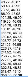

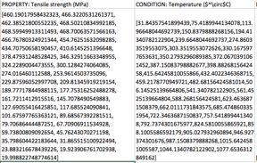
22 Extracting prop/cond from plots x, y PROPERTY 22 CONDITION
23 Python Citrination client Programmatically push and pull files from Citrination - Query Citrination for properties relevant to your research - Prediction queries on trained models 23
24 Data workshop 1. Identify any data you wish to digitize. If you do not have any, there is an Al alloy dataset shared with the MIDDMI team. 2. Using PIF fields, decide how to organize the relevant info in your dataset. 3. Upload to Citrination and present the organizational choices you made. 4. Consider where you are in the AI workflow stages. 24
25 Data Ingestion First Pass Model Model Refinement Define Design Space Sequential Learning Gather initial data Format initial data for upload Seek out additional data sources Identify relevant inputs and outputs Build first pass models Develop more informative input features Explore alternative model structures Include data from additional sources in model Define constraints for design candidates Generate a custom design space Retrain ML model Get design suggestion from ML model Run experiment Build refined model Write custom ingesters Upload new data
26 Citrine Informatics The data analytics platform for the physical world The image part with relationship ID rid2 was not found in the file. Thank you
Geodatabase Programming with Python John Yaist
 Geodatabase Programming with Python John Yaist DevSummit DC February 26, 2016 Washington, DC Target Audience: Assumptions Basic knowledge of Python Basic knowledge of Enterprise Geodatabase and workflows
Geodatabase Programming with Python
 DevSummit DC February 11, 2015 Washington, DC Geodatabase Programming with Python Craig Gillgrass Assumptions Basic knowledge of python Basic knowledge enterprise geodatabases and workflows Please turn
OECD QSAR Toolbox v.4.1. Step-by-step example for building QSAR model
 OECD QSAR Toolbox v.4.1 Step-by-step example for building QSAR model Background Objectives The exercise Workflow of the exercise Outlook 2 Background This is a step-by-step presentation designed to take
Yes, the Library will be accessible via the new PULSE and the existing desktop version of PULSE.
 F R E Q U E N T L Y A S K E D Q U E S T I O N S THE LIBRARY GENERAL W H A T I S T H E L I B R A R Y? The Library is the new, shorter, simpler name for the Business Development (Biz Dev) Library. It s your
OECD QSAR Toolbox v.3.3. Step-by-step example of how to build a userdefined
 OECD QSAR Toolbox v.3.3 Step-by-step example of how to build a userdefined QSAR Background Objectives The exercise Workflow of the exercise Outlook 2 Background This is a step-by-step presentation designed
OECD QSAR Toolbox v.4.1. Tutorial illustrating new options for grouping with metabolism
 OECD QSAR Toolbox v.4.1 Tutorial illustrating new options for grouping with metabolism Outlook Background Objectives Specific Aims The exercise Workflow 2 Background Grouping with metabolism is a procedure
Administering your Enterprise Geodatabase using Python. Jill Penney
 Administering your Enterprise Geodatabase using Python Jill Penney Assumptions Basic knowledge of python Basic knowledge enterprise geodatabases and workflows You want code Please turn off or silence cell
EMMA : ECDC Mapping and Multilayer Analysis A GIS enterprise solution to EU agency. Sharing experience and learning from the others
 EMMA : ECDC Mapping and Multilayer Analysis A GIS enterprise solution to EU agency. Sharing experience and learning from the others Lorenzo De Simone, GIS Expert/ EMMA Project Manager 2014 GIS Workshop,
No. of Days. Building 3D cities Using Esri City Engine ,859. Creating & Analyzing Surfaces Using ArcGIS Spatial Analyst 1 7 3,139
 Q3 What s New? Creating and Editing Data with ArcGIS Pro Editing and Maintaining Parcels Using ArcGIS Spatial Analysis Using ArcGIS Pro User Workflows for ArcGIS Online Organizations Q3-2018 ArcGIS Desktop
Leveraging ArcGIS Online Elevation and Hydrology Services. Steve Kopp, Jian Lange
 Leveraging ArcGIS Online Elevation and Hydrology Services Steve Kopp, Jian Lange Topics An overview of ArcGIS Online Elevation Analysis Using Elevation Analysis Services in ArcGIS for Desktop Using Elevation
OECD QSAR Toolbox v.4.0. Tutorial on how to predict Skin sensitization potential taking into account alert performance
 OECD QSAR Toolbox v.4.0 Tutorial on how to predict Skin sensitization potential taking into account alert performance Outlook Background Objectives Specific Aims Read across and analogue approach The exercise
OECD QSAR Toolbox v.4.1. Tutorial on how to predict Skin sensitization potential taking into account alert performance
 OECD QSAR Toolbox v.4.1 Tutorial on how to predict Skin sensitization potential taking into account alert performance Outlook Background Objectives Specific Aims Read across and analogue approach The exercise
OECD QSAR Toolbox v.3.2. Step-by-step example of how to build and evaluate a category based on mechanism of action with protein and DNA binding
 OECD QSAR Toolbox v.3.2 Step-by-step example of how to build and evaluate a category based on mechanism of action with protein and DNA binding Outlook Background Objectives Specific Aims The exercise Workflow
Managing Imagery and Raster Data Using Mosaic Datasets
 Esri International User Conference San Diego, California Technical Workshops July 25, 2012 Managing Imagery and Raster Data Using Mosaic Datasets Hong Xu, Prashant Mangtani Presentation Overview Introduction
DP Project Development Pvt. Ltd.
 Dear Sir/Madam, Greetings!!! Thanks for contacting DP Project Development for your training requirement. DP Project Development is leading professional training provider in GIS technologies and GIS application
OECD QSAR Toolbox v.3.4. Step-by-step example of how to build and evaluate a category based on mechanism of action with protein and DNA binding
 OECD QSAR Toolbox v.3.4 Step-by-step example of how to build and evaluate a category based on mechanism of action with protein and DNA binding Outlook Background Objectives Specific Aims The exercise Workflow
OECD QSAR Toolbox v.3.3. Step-by-step example of how to build and evaluate a category based on mechanism of action with protein and DNA binding
 OECD QSAR Toolbox v.3.3 Step-by-step example of how to build and evaluate a category based on mechanism of action with protein and DNA binding Outlook Background Objectives Specific Aims The exercise Workflow
Troubleshooting Replication and Geodata Services. Liz Parrish & Ben Lin
 Troubleshooting Replication and Geodata Services Liz Parrish & Ben Lin AGENDA: Troubleshooting Replication and Geodata Services Overview Demo Troubleshooting Q & A Overview of Replication Liz Parrish What
OECD QSAR Toolbox v.3.4. Example for predicting Repeated dose toxicity of 2,3-dimethylaniline
 OECD QSAR Toolbox v.3.4 Example for predicting Repeated dose toxicity of 2,3-dimethylaniline Outlook Background Objectives The exercise Workflow Save prediction 2 Background This is a step-by-step presentation
Agilent MassHunter Quantitative Data Analysis
 Agilent MassHunter Quantitative Data Analysis Presenters: Howard Sanford Stephen Harnos MassHunter Quantitation: Batch and Method Setup Outliers, Data Review, Reporting 1 MassHunter Quantitative Analysis
Workforce Development Enables Your Adoption Strategy
 Workforce Development Enables Your Adoption Strategy Michael Green Organizational Adoption Consultant Matthew Karl Training Consultant Agenda Adopt, Embrace, Utilize Components of Change Management Workforce
Deep-dive into PyMISP MISP - Malware Information Sharing Platform & Threat Sharing
 Deep-dive into PyMISP MISP - Malware Information Sharing Platform & Threat Sharing Team CIRCL http://www.misp-project.org/ Twitter: @MISPProject MISP Training @ Helsinki 20180423 Context MISP is complex
OECD QSAR Toolbox v.3.3
 OECD QSAR Toolbox v.3.3 Step-by-step example on how to predict the skin sensitisation potential of a chemical by read-across based on an analogue approach Outlook Background Objectives Specific Aims Read
OECD QSAR Toolbox v.3.4
 OECD QSAR Toolbox v.3.4 Step-by-step example on how to predict the skin sensitisation potential approach of a chemical by read-across based on an analogue approach Outlook Background Objectives Specific
OECD QSAR Toolbox v.4.1. Step-by-step example for predicting skin sensitization accounting for abiotic activation of chemicals
 OECD QSAR Toolbox v.4.1 Step-by-step example for predicting skin sensitization accounting for abiotic activation of chemicals Background Outlook Objectives The exercise Workflow 2 Background This is a
Web GIS Administration: Tips and Tricks
 EdUC 2017 July 8 th, 2017 Web GIS Administration: Tips and Tricks Geri Miller Agenda Concerns Acknowledged User Management Content Management Monitoring Licensing and logins Sophistication of IT support
Search for the Gulf of Carpentaria in the remap search bar:
 This tutorial is aimed at getting you started with making maps in Remap (). In this tutorial we are going to develop a simple classification of mangroves in northern Australia. Before getting started with
RIDOT GIS Activities RIGIS User Group Meeting Stephen Kut RIDOT
 RIDOT GIS Activities RIGIS User Group Meeting Stephen Kut RIDOT Presentation Topics Pictometry Imagery Project Update GIS Historic Review Project GIS / CAD Integration Pictometry Project Details Digital
Innovation. The Push and Pull at ESRI. September Kevin Daugherty Cadastral/Land Records Industry Solutions Manager
 Innovation The Push and Pull at ESRI September 2004 Kevin Daugherty Cadastral/Land Records Industry Solutions Manager The Push and The Pull The Push is the information technology that drives research and
Strategies for Integrating CAD and BIM in ArcGIS. Don Kuehne Esri 3D Product Manager: CAD/BIM/AEC
 Strategies for Integrating CAD and BIM in ArcGIS Don Kuehne Esri 3D Product Manager: CAD/BIM/AEC CAD Digital Drawing CAD in ArcGIS Desktop CAD in Desktop CAD as Data CAD as a Map EXPORT TO CAD Create and
Esri Production Mapping: An Introduction
 Esri Production Mapping: An Introduction Amber Bethell & Joseph Sheffield Esri UC 2014 Technical Workshop Your organization s processes Collect Share Manage Produce Your organization s needs Standardization
Data Aggregation with InfraWorks and ArcGIS for Visualization, Analysis, and Planning
 CI125230 Data Aggregation with InfraWorks and ArcGIS for Visualization, Analysis, and Planning Stephen Brockwell Brockwell IT Consulting Inc. Sean Kinahan Brockwell IT Consulting Inc. Learning Objectives
Steve Pietersen Office Telephone No
 Steve Pietersen Steve.Pieterson@durban.gov.za Office Telephone No. 031 311 8655 Overview Why geography matters The power of GIS EWS GIS water stats EWS GIS sanitation stats How to build a GIS system EWS
Getting Started with Community Maps
 Esri International User Conference San Diego, California Technical Workshops July 24, 2012 Getting Started with Community Maps Shane Matthews and Tamara Yoder Topics for this Session ArcGIS is a complete
OECD QSAR Toolbox v.4.1
 OECD QSAR Toolbox v.4.1 Step-by-step example on how to predict the skin sensitisation potential approach of a chemical by read-across based on an analogue approach Outlook Background Objectives Specific
No. of Days. ArcGIS 3: Performing Analysis ,431. Building 3D cities Using Esri City Engine ,859
 What s New? Creating Story Maps with ArcGIS Field Data Collection and Management Using ArcGIS Get Started with Insights for ArcGIS Introduction to GIS Using ArcGIS & ArcGIS Pro: Essential Workflow Migrating
No. of Days. ArcGIS Pro for GIS Professionals ,431. Building 3D cities Using Esri City Engine ,859
 What s New? Creating Story Maps with ArcGIS Field Data Collection and Management Using ArcGIS Get Started with Insights for ArcGIS Introduction to GIS Using ArcGIS & ArcGIS Pro: Essential Workflow Migrating
Creating Empirical Calibrations
 030.0023.01.0 Spreadsheet Manual Save Date: December 1, 2010 Table of Contents 1. Overview... 3 2. Enable S1 Calibration Macro... 4 3. Getting Ready... 4 4. Measuring the New Sample... 5 5. Adding New
Road Ahead: Linear Referencing and UPDM
 Road Ahead: Linear Referencing and UPDM Esri European Petroleum GIS Conference November 7, 2014 Congress Centre, London Your Work Making a Difference ArcGIS Is Evolving Your GIS Is Becoming Part of an
What s Cooking? Predicting Cuisines from Recipe Ingredients
 What s Cooking? Predicting Cuisines from Recipe Ingredients Kevin K. Do Department of Computer Science Duke University Durham, NC 27708 kevin.kydat.do@gmail.com Abstract Kaggle is an online platform for
Analyzing the Operational Environment
 Esri International User Conference July 23 27 San Diego Convention Center Analyzing the Operational Environment Matthew Funk (Esri) David Mitchell (Esri) Tim Burley (Helyx SIS) Geospatial Enterprise for
Arcgis Tutorial Manual READ ONLINE
 Arcgis Tutorial Manual READ ONLINE ArcGIS Desktop 10 Trial Help - Note: The Quick Start Guide contains instructions that do not pertain to the trial edition. Many tutorials are found in the ArcGIS Desktop
OECD QSAR Toolbox v.3.3
 OECD QSAR Toolbox v.3.3 Step-by-step example of how to predict aquatic toxicity to Tetrahymena pyriformis by trend analysis using category pruning capabilities Outlook Background Objectives Specific Aims
Introducing Geospatial Components into GSBPM Janusz Dygaszewicz
 Introducing Geospatial Components into GSBPM Janusz Dygaszewicz 11 13 April 2018 Geneva - ModernStats World Workshop 2018 The proposal of the GSBPM model improvement in terms of spatial component of the
GIS Boot Camp for Education June th, 2011 Day 1. Instructor: Sabah Jabbouri Phone: (253) x 4854 Office: TC 136
 x 4854 Office: TC 136") GIS Boot Camp for Education June 27-30 th, 2011 Day 1 Instructor: Sabah Jabbouri Phone: (253) 833-9111 x 4854 Office: TC 136 Email: sjabbouri@greenriver.edu http://www.instruction.greenriver.edu/gis/ Summer
GIS Boot Camp for Education June 27-30 th, 2011 Day 1 Instructor: Sabah Jabbouri Phone: (253) 833-9111 x 4854 Office: TC 136 Email: sjabbouri@greenriver.edu http://www.instruction.greenriver.edu/gis/ Summer
Tutorial Three: Loops and Conditionals
 Tutorial Three: Loops and Conditionals Imad Pasha Chris Agostino February 18, 2015 1 Introduction In lecture Monday we learned that combinations of conditionals and loops could make our code much more
Workstations at Met Éireann. Kieran Commins Head Applications Development
 Workstations at Met Éireann Kieran Commins Head Applications Development Background For many years Met Éireann has used several systems for visualisation of data X-charts for NWP Intranet for Satellite/radar
Introduction to ArcGIS Server - Creating and Using GIS Services. Mark Ho Instructor Washington, DC
 Introduction to ArcGIS Server - Creating and Using GIS Services Mark Ho Instructor Washington, DC Technical Workshop Road Map Product overview Building server applications GIS services Developer Help resources
Esri Production Mapping: Map Automation & Advanced Cartography MADHURA PHATERPEKAR JOE SHEFFIELD
 Esri Production Mapping: Map Automation & Advanced Cartography MADHURA PHATERPEKAR JOE SHEFFIELD Traditional Cartography What you really want Cartographic Workflow Output Cartographic Data Symbology Layout
Machine Learning Analyses of Meteor Data
 WGN, The Journal of the IMO 45:5 (2017) 1 Machine Learning Analyses of Meteor Data Viswesh Krishna Research Student, Centre for Fundamental Research and Creative Education. Email: krishnaviswesh@cfrce.in
Geodatabase Replication for Utilities Tom DeWitte Solution Architect ESRI Utilities Team
 Geodatabase Replication for Utilities Tom DeWitte Solution Architect ESRI Utilities Team 1 Common Data Management Issues for Utilities Utilities are a distributed organization with the need to maintain
ArcGIS Runtime: Migrating from ArcGIS Engine. Rex Hansen
 ArcGIS Runtime: Migrating from ArcGIS Engine Rex Hansen Thank You to Our Sponsors Migrating from ArcGIS Engine to ArcGIS Runtime ArcGIS Runtime API: new and evolved workflows on all platforms Windows Linux
Chapter 18. Electrochemistry
 Chapter 18 Electrochemistry Section 17.1 Spontaneous Processes and Entropy Section 17.1 http://www.bozemanscience.com/ap-chemistry/ Spontaneous Processes and Entropy Section 17.1 Spontaneous Processes
You are Building Your Organization s Geographic Knowledge
 You are Building Your Organization s Geographic Knowledge And Increasingly Making it Available Sharing Data Publishing Maps and Geo-Apps Developing Collaborative Approaches Citizens Knowledge Workers Analysts
ArcGIS 10.1 An Overview of the System
 ArcGIS 10.1 An Overview of the System ArcGIS 10.1 An Overview of the System Damian Spangrud Director of Solutions, Esri Redlands, CA USA ArcGIS 10.1 Web Cloud Online Mobile Enterprise Desktop ArcGIS 10.1
IUCLID Substance Data
 1 Workshop on CEFIC LRI Project EEM9.4 LRI AMBIT with IUCLID6 support and extended search capabilities IUCLID Substance Data Nikolay Kochev Ideaconsult Ltd. Sofia,Bulgaria 2 Chemical structure vs. Substance
Bentley Map Advancing GIS for the World s Infrastructure
 Bentley Map Advancing GIS for the World s Infrastructure Presentation Overview Why would you need Bentley Map? What is Bentley Map? Where is Bentley Map Used? Why would you need Bentley Map? Because your
From BASIS DD to Barista Application in Five Easy Steps
 Y The steps are: From BASIS DD to Barista Application in Five Easy Steps By Jim Douglas our current BASIS Data Dictionary is perfect raw material for your first Barista-brewed application. Barista facilitates
Geog 469 GIS Workshop. Managing Enterprise GIS Geodatabases
 Geog 469 GIS Workshop Managing Enterprise GIS Geodatabases Outline 1. Why is a geodatabase important for GIS? 2. What is the architecture of a geodatabase? 3. How can we compare and contrast three types
Spatial Data Management of Bio Regional Assessments Phase 1 for Coal Seam Gas Challenges and Opportunities
 Spatial Data Management of Bio Regional Assessments Phase 1 for Coal Seam Gas Challenges and Opportunities By Dr Zaffar Sadiq Mohamed-Ghouse Principal Consultant, Spatial & IT, GHD zaffar.sadiq@ghd.com
OECD QSAR Toolbox v.3.3. Predicting skin sensitisation potential of a chemical using skin sensitization data extracted from ECHA CHEM database
 OECD QSAR Toolbox v.3.3 Predicting skin sensitisation potential of a chemical using skin sensitization data extracted from ECHA CHEM database Outlook Background The exercise Workflow Save prediction 23.02.2015
The File Geodatabase API. Craig Gillgrass Lance Shipman
 The File Geodatabase API Craig Gillgrass Lance Shipman Schedule Cell phones and pagers Please complete the session survey we take your feedback very seriously! Overview File Geodatabase API - Introduction
From BASIS DD to Barista Application in Five Easy Steps
 Y The steps are: From BASIS DD to Barista Application in Five Easy Steps By Jim Douglas our current BASIS Data Dictionary is perfect raw material for your first Barista-brewed application. Barista facilitates
Enabling Success in Enterprise Asset Management: Case Study for Developing and Integrating GIS with CMMS for a Large WWTP
 Enabling Success in Enterprise Asset Management: Case Study for Developing and Integrating GIS with CMMS for a Large WWTP Allison Blake, P.E. 1*, Matthew Jalbert, P.E. 2, Julia J. Hunt, P.E. 2, Mazen Kawasmi,
ArcGIS Pro Q&A Session. NWGIS Conference, October 11, 2017 With John Sharrard, Esri GIS Solutions Engineer
 ArcGIS Pro Q&A Session NWGIS Conference, October 11, 2017 With John Sharrard, Esri GIS Solutions Engineer jsharrard@esri.com ArcGIS Desktop The applications ArcGIS Pro ArcMap ArcCatalog ArcScene ArcGlobe
Changes in Esri GIS, practical ways to be ready for the future
 Changes in Esri GIS, practical ways to be ready for the future John Sharrard, Esri April 16, 2015 The only thing that is constant is change. Heraclitus, ca. 500 B.C. My story (of experiencing change) Changes
Geodatabase Management Pathway
 Geodatabase Management Pathway Table of Contents ArcGIS Desktop II: Tools and Functionality 3 ArcGIS Desktop III: GIS Workflows and Analysis 6 Building Geodatabases 8 Data Management in the Multiuser Geodatabase
The ALMA Science Archive. Felix Stoehr Subsystem Scientist
 The ALMA Science Archive Felix Stoehr Subsystem Scientist ALMA u 66 antennas at 5000m elevation in the Atacama Desert u Interferometry with baselines up to 16km u Wavelength range from 3mm to 400µm (84
GC and CELPP: Workflows and Insights
 GC and CELPP: Workflows and Insights Xianjin Xu, Zhiwei Ma, Rui Duan, Xiaoqin Zou Dalton Cardiovascular Research Center, Department of Physics and Astronomy, Department of Biochemistry, & Informatics Institute
Data Uploads 6: Instructions for Inventory
 Data Uploads 6: Instructions for Inventory Explanation of Required, Recommended, and Optional Fields Frequently Asked Questions about Uploading Chemical Data Once the other necessary data have been loaded
Climate Risk Visualization for Adaptation Planning and Emergency Response
 Climate Risk Visualization for Adaptation Planning and Emergency Response NCR Flood Fact Finding Workshop Ricardo Saavedra ricardo@vizonomy.com Social Media, Mobile, and Big Data St. Peter s Basilica,
Sequential Pattern Mining
 Sequential Pattern Mining Lecture Notes for Chapter 7 Introduction to Data Mining Tan, Steinbach, Kumar From itemsets to sequences Frequent itemsets and association rules focus on transactions and the
ArcGIS Data Reviewer: Assessing Positional Accuracy. Roslyn Dunn
 ArcGIS Data Reviewer: Assessing Positional Accuracy Roslyn Dunn What is ArcGIS Data Reviewer? Data Quality Management for ArcGIS Provides - Rule-based validation - Interactive tools - Track errors Validate
Geodatabase Best Practices. Dave Crawford Erik Hoel
 Geodatabase Best Practices Dave Crawford Erik Hoel Geodatabase best practices - outline Geodatabase creation Data ownership Data model Data configuration Geodatabase behaviors Data integrity and validation
OECD QSAR Toolbox v.3.0
 OECD QSAR Toolbox v.3.0 Step-by-step example of how to categorize an inventory by mechanistic behaviour of the chemicals which it consists Background Objectives Specific Aims Trend analysis The exercise
Electrochemistry. Part One: Introduction to Electrolysis and the Electrolysis of Molten Salts
 Part One: Introduction to Electrolysis and the Electrolysis of Molten Salts What do I need to know about electrochemistry? Electrochemistry Learning Outcomes: Candidates should be able to: a) Describe
6.867 Machine Learning
 6.867 Machine Learning Problem Set 2 Due date: Wednesday October 6 Please address all questions and comments about this problem set to 6867-staff@csail.mit.edu. You will need to use MATLAB for some of
Informatics 2B: Learning and Data Lecture 10 Discriminant functions 2. Minimal misclassifications. Decision Boundaries
 Overview Gaussians estimated from training data Guido Sanguinetti Informatics B Learning and Data Lecture 1 9 March 1 Today s lecture Posterior probabilities, decision regions and minimising the probability
ArcGIS for Local Government
 Wednesday, June 29th ArcGIS for Local Government Dan Rose, GIS Analyst WaterOne IT/GIS Agenda / Talking Points What is the LGIM? WaterOne s GIS and LGIM background Our geodatabase redesign Our strategies
Enabling ENVI. ArcGIS for Server
 Enabling ENVI throughh ArcGIS for Server 1 Imagery: A Unique and Valuable Source of Data Imagery is not just a base map, but a layer of rich information that can address problems faced by GIS users. >
OECD QSAR Toolbox v.3.3. Step-by-step example of how to categorize an inventory by mechanistic behaviour of the chemicals which it consists
 OECD QSAR Toolbox v.3.3 Step-by-step example of how to categorize an inventory by mechanistic behaviour of the chemicals which it consists Background Objectives Specific Aims Trend analysis The exercise
M E R C E R W I N WA L K T H R O U G H
 H E A L T H W E A L T H C A R E E R WA L K T H R O U G H C L I E N T S O L U T I O N S T E A M T A B L E O F C O N T E N T 1. Login to the Tool 2 2. Published reports... 7 3. Select Results Criteria...
A People Strategy for Organizations
 Workforce Development Planning: A People Strategy for Organizations Michael Green, Training Sales Manager Tamara Adamson, Training Consultant Agenda Change Workforce Development Plan Breakout Session Case
GIS Level 2. MIT GIS Services
 GIS Level 2 MIT GIS Services http://libraries.mit.edu/gis Email: gishelp@mit.edu TOOLS IN THIS WORKSHOP - Definition Queries - Create a new field in the attribute table - Field Calculator - Add XY Data
GPS Mapping with Esri s Collector App. What We ll Cover
 GPS Mapping with Esri s Collector App Part 1: Overview What We ll Cover Part 1: Overview and requirements Part 2: Preparing the data in ArcGIS for Desktop Part 3: Build a web map in ArcGIS Online Part
inaturalist Training AOP inaturalist Training May 21, 2016 Slide 1
 inaturalist Training AOP inaturalist Training May 21, 2016 Slide 1 What is inaturalist? inaturalist is a free tool that allows people to record, share, and discuss their observations inaturalist is designed
COMPOUND REGISTRATION
 CONTENTS: Register a New Compound Register a New Batch Search for a Compound Edit a Batch/Create a New Lot Create a New Salt and Isotope Upload an Analytical File Validation Errors Contact Us www.schrodinger.com
Introduction to Google Drive Objectives:
 Introduction to Google Drive Objectives: Learn how to access your Google Drive account Learn to create new documents using Google Drive Upload files to store on Google Drive Share files and folders with
Creating Basemaps to Manage Buildings and Facilities
 Esri International User Conference San Diego, California Technical Workshops July 26, 2012 Creating Basemaps to Manage Buildings and Facilities Mark Stewart and Tamara Yoder Topics for this Session Overview
 www.goldensoftware.com Why Create a Thematic Map? A thematic map visually represents the geographic distribution of data. MapViewer will help you to: understand demographics define sales or insurance territories
Introduction to Portal for ArcGIS
 Introduction to Portal for ArcGIS Derek Law Product Management March 10 th, 2015 Esri Developer Summit 2015 Agenda Web GIS pattern Product overview Installation and deployment Security and groups Configuration
Remember that C is a constant and ë and n are variables. This equation now fits the template of a straight line:
 CONVERTING NON-LINEAR GRAPHS INTO LINEAR GRAPHS Linear graphs have several important attributes. First, it is easy to recognize a graph that is linear. It is much more difficult to identify if a curved
GIS Software. Evolution of GIS Software
 GIS Software The geoprocessing engines of GIS Major functions Collect, store, mange, query, analyze and present Key terms Program collections of instructions to manipulate data Package integrated collection
Systematic Review Round 7 Application Form
 Systematic Review Round 7 Application Form SR7/1063 1. BASIC PROJECT INFO (i) Title of Proposed Review * Systematic review question.download detailed SR7 questions here Title of the study if more focused
CLICK HERE TO KNOW MORE
 CLICK HERE TO KNOW MORE Geoinformatics Applications in Land Resources Management G.P. Obi Reddy National Bureau of Soil Survey & Land Use Planning Indian Council of Agricultural Research Amravati Road,
Copernicus Data Driven Services for Regional & Local Government in Greece
 Workshop on Copernicus uptake by public authorities Gabriel Mavrellis CEO, Geospatial Enabling Technologies Copernicus Data Driven Services for Regional & Local Government in Greece The Company Copernicus
Integration of ArcFM UT with SCADA, SAP, MAXIMO and Network Calculation
 Integration of ArcFM UT with SCADA, SAP, MAXIMO and Network Calculation Peter Harabin (VSE) Martin Mydliar (ArcGEO) July 9, 2013 Esri International User Conference Agenda > Business/process part = WHAT
How to create a new geodatabase using the extract data wizard. 1. How to Extract the Schema to create a Geodatabase using an existing design.
 How to create a new geodatabase using the extract data wizard The Extract Data Wizard can be used to create a new database based on an existing geodatabase. This tool may be used in the following cases:
Click Prediction and Preference Ranking of RSS Feeds
 Click Prediction and Preference Ranking of RSS Feeds 1 Introduction December 11, 2009 Steven Wu RSS (Really Simple Syndication) is a family of data formats used to publish frequently updated works. RSS
CAD: Introduction to using CAD Data in ArcGIS. Kyle Williams & Jeff Reinhart
 CAD: Introduction to using CAD Data in ArcGIS Kyle Williams & Jeff Reinhart What we will accomplish today Overview of ArcGIS CAD Support Georeferencing CAD data for ArcGIS How Mapping Specification for