A People Strategy for Organizations
|
|
|
- Alexia Rosalyn Haynes
- 5 years ago
- Views:
Transcription


1 Workforce Development Planning: A People Strategy for Organizations Michael Green, Training Sales Manager Tamara Adamson, Training Consultant

2 Agenda Change Workforce Development Plan Breakout Session Case Study Discussions Next Steps

3 Goals for this session When you leave this session you will be able to: Justify the effort to create a Workforce Development Plan as well as the eventual Training Use the three step process of a Workforce Development Plan to support change Drive results through effective training

4 Organizational Change and Individual Change Credit: Prosci ADKAR Change Management Model

5 Training spending and project success Source: IDC, Training's Impact on Projects Survey


6 Our Platform and its Capabilities are Advancing 10.5 Incremental Software Release Pro Pro 2.0 May 10.6 Pro 2.1 November Continuous Online Improvements Smart Mapping Big Data GeoAnalytics Crowdsourcing Machine Learning Scientific Modeling Ortho Mapping Spatiotemporal Utility Networks Massive Point Clouds Spatial Statistics Real-Time Volumetric Data 3D Cities Distributed GIS Web Raster Analysis Augmented Reality Imagery... Focused on Quality, User Needs and Innovation
7 What is a workforce development plan? A strategy-driven learning plan that aligns training resources to your organization s vision and goals to ensure the roles in your workforce have the skills to execute on leveraging the ArcGIS Platform.


8 Workforce development planning is a process Three levels of workforce development planning Enterprise Individual Project & Department
9 Workforce Development Planning Implement Strategy Modify as needed Alignment Organizational objectives Geo-discovery Workforce roles Action Analysis Skills requirements Timelines, priorities and budgets Delivery methods (training plan)

10 Workforce Development Process Mission and Goals Alignment Applications of GIS Roles Discovery


11 Essential Patterns of a Location Strategy Location Enablement Constituent Engagement Decision Support Field Mobility Analytics Location Data Management Empower all users to discover, use, make and share maps Get feedback and communicate with external constituents Support organization decision making activities Get information into and out of the field Describe, predict, and improve business performance Collect, organize and exchange data about all assets and resources
12 Workforce Development Process Training Resources Analysis Identify Delivery Method Budget Planning
13 Workforce Development Process Execute Plan Action Review Plan
14 Alignment


15 Analysis: Connecting Patterns to Strategic Goals Geospatial Roles Identified Training Recommendations by Role
16 Action Priority of training will be based upon GIS Title, IT Title, full-time GIS user, project requirement, pre-reqs, available software/extensions, and previous coursework. GIS Foundation ArcGIS 1: Introduction to GIS ArcGIS 2: Essential Workflows ArcGIS Online Subscriptions for Organizations: User Workflows (ILO only) Exploring Enterprise GIS: A Workshop for Leaders Geodata Building Geodatabases Editing Data with ArcGIS for Desktop Spatial Analysis ArcGIS 3: Performing Analysis Designing and Sharing Designing Maps with ArcGIS ArcGIS 4: Sharing Content on the Web ArcGIS Online Subscriptions for Organizations: Publisher Workflows Data Management Configuring and Managing the Multiuser Geodatabase Replication Deploying and Maintaining a Multiuser Geodatabase Implementing Versioned Workflows in a Multiuser Geodatabase Distributing Data Using Geodatabase Practicing Geodesign Using ArcGIS Server Management ArcGIS for Server: Site Configuration and Administration System Architecture Design Strategies Courses for Developers Training Plan Python Developing Web Apps with ArcGIS API for Javascript ArcGIS Runtime SDK for Android Bootcamp Introduction to Geoprocessing Scripts Using ArcGIS Runtime SDK for ios Bootcamp Programming ArcGIS for Desktop Using Addins Specialty Classes & Solutions Introduction to ArcGIS Pro for GIS Professionals (ArcGIS Pro) Working with CAD Data in ArcGIS Market Analysis Using Esri Business Analyst (Business Professionals) Hydrologic and Hydrauldraulic Analyses Using ArcGIS Arc Hydro: GIS for Water Resources Editing and M Wor ArcG Implementing Esri Geoportal R Recommended Course Course Type ILT ILT ILO ILT ILT ILT ILT ILT ILT ILT ILT ITL ITL ILT ILT ILT ILT ITL ITL ILT ILT ILT ILT ILT ILT ILT ITL O Optional Course Course Duration [days] C Completed Course Organizational Roles Agency Job Title GIS Team OIR GIS Director Pedersen, Dennis O O R OIR GIS Analyst 3 Meeks, Chris O R O O R R R OIR GIS Analyst 3 Herrington, Brandon O O O R R R O O R OIR GIS Analyst 3 White, Suzanne R O O R R R R R O O O R R R R R OIR Info Systems Tech Cons Griswold, Andrew R O O R O O O O R O O OIR GIS Analyst 3 Lane, Matt R O O R R R O O R OIR GIS Tech 2 Thompson, Nancy O R O O R R R OIR GIS Analyst 2 Pittenger, Ryan R O O O O O R O O OIR GIS Analyst 2 Gilliam, Patrick R R R R R O O OIR GIS Analyst 2 (new position) Williams, Kevin R O O R O O O O R O O OIR GIS Analyst 2 (new position) Riter, Michael R O O R O O O O R O O Military GIS Analyst 2 Yu, HeeChong O O R R R R O R R O R O R R R Safety GIS Analyst 2 Tucker, Ray R R R R R TDEC GIS Analyst 3 Buchanan, Tim TDOT IT Manager Senior McDonough, Kim TDOT GIS Analyst 2 Anderson, Peggy TDOT Data Architect Letillier, April R R R R R R R TWRA GIS Tech Mgr 1 Jones, Jeanette R R R R O R R O O O R O O TWRA Info Resource Spec 3 Porter, Tracy O O R O O O O O R O TWRA Info Resource Spec 3 Barrett, Lynn R R R R R R R R R R R R R R


17 Action - Delivery Instructor-led E-Learning MOOCs Certifications
 Online (virtual classroom) Your facility (on your infrastructure or mobile lab)")
18 Action - Delivery Training Instructor-led Benefits: Interactive Peer-to-peer learning Hands on exercises Delivery: In a Esri Training Facility (14 in the U.S.) Online (virtual classroom) Your facility (on your infrastructure or mobile lab)

19 Action - Delivery Training Coaching/Custom Coaching Best practices Agency tasks & specific workflows Student application using a copy of client data Full Custom Class Unique and specific to organizational needs Can include pieces from existing courses Change in delivery method (remove exercises)
20 Let s look at a more detailed example Seattle Parks and Recreation


21 Process to plan Identity Organizational Goals The three-step workforce development process results in a workforce development plan ALIGNMENT ACTION ANALYSIS
22 Align GIS Patterns to organization s strategic goal Location Enablement Location Data Management Analytics Field Mobility Decision Support Constituent Engagement Empower all users to discover, use, make and share maps Collect, organize and exchange data about all assets and resources Describe, predict, and improve business performance Get information into and out of the field Support organization decision making activities Get feedback and make informed decisions
23 Develop GIS Goals ALIGNMENT ACTION ANALYSIS Organization Goal Steward Seattle s parks for long-term sustainability GIS Pattern GIS Goal GIS Capability Constituent engagement Decision Support Location Data Management Analytics Decision Support Support Park Legacy Plan with maps for status reports and web maps for interactive web reporting Support Park Planning using GIS to identify neighborhoods that are under served by useable park open space using a Gap Analysis model??
24 Align GIS Capabilities to GIS goals Foundation Collaboration and Sharing Data Collection and Management Developer Imagery and Remote Sensing Mapping and Visualization Real-Time GIS Spatial Analytics 3D GIS Certification
25 Process to plan Organization Goal Steward Seattle s parks for long-term sustainability GIS Pattern GIS Goal GIS Capability ALIGNMENT Decision Support Constituent Engagement Support Park Legacy Plan with maps for status reports and web maps for interactive web reporting Real-Time GIS Collaboration & Sharing ACTION ANALYSIS Location Data Management Analytics Decision Support Support Park Planning using GIS to identify neighborhoods that are under served by useable park open space using a Gap Analysis model Spatial Analytics Real-Time GIS Location Enablement Location Data Management Analytics Field Mobility Decision Support Constituent Engagement Empower all users to discover, use, make and share maps Collect, organize and exchange data about all assets and resources Describe, predict, and improve business performance Get information into and out of the field Support organization decision making activities Get feedback and make informed decisions
26 Activity: Identify Capabilities aligned to Goals Review the Organizational Goals, Patterns of Use, and the GIS Goals Identify the Capabilities that could be applied to these goals Optional: - Work through a goal you have at your organization
27 Align GIS Capabilities to GIS goals Foundation Collaboration and Sharing Data Collection and Management Developer Imagery and Remote Sensing Mapping and Visualization Real-Time GIS Spatial Analytics 3D GIS Certification
28 What are your group results from the exercise?

29 Process to plan Identify Roles The three-step workforce development process results in a workforce development plan ALIGNMENT ACTION ANALYSIS Sara
30 Align GIS Capabilities to organization s strategic goal
31 Process to plan System Administrator This role s responsibilities include: Configures and maintains the GIS infrastructure to conform to set IT policies Maintains enterprise spatial databases with governance to include data modeling, geodetic control parameters, and metadata documentation System performance tuning/troubleshooting Related server software (upgrades and service packs) Deploys GIS web functionality with appropriate security and server considerations *System Administrator is not a formal position within Parks. The workflows assigned to this role are performed by a combination of Parks IT, the GIS Manager and SPU ALIGNMENT GIS Pattern Workflows and Technical Competencies ACTION ANALYSIS Location Data Management Data Management Workflows Managing Data Quality Feature Editing for Desktop Automating Editing Tasks Feature Editing for Server / Mobile Data Editing Workflows Managing Feature Data Managing Raster Data Designing / Managing Geodatabases Managing Multiuser Geodatabase Environment Data Documentation Esri Instructor-Led Training 1. ArcGIS for Server: Site Configuration and Administration (3 Days) 2. System Architecture Design Strategies (3 Days) 3. Building Geodatabases (3 Days) 4. Configuring and Managing the Multiuser Geodatabase (3 Days) 5. Implementing Versioned Workflows in a Multiuser Geodatabase (3 Days) Esri e-learning Training 1. Archiving Data in a Multiuser Geodatabase (Web Course, 2 Hours, Free) 2. Data QC with ArcGIS: Automating Validation (Web Course, 3Hours, Free) 3. Transforming Data Using Extract, Transform, and Load Processes (Web Course, 3 Hours, Free) 4. Using ArcGIS Data Reviewer to Assess Data Quality (Training Seminar, 1 Hour, Free) 5. Creating and Sharing GIS Content Using ArcGIS Online (Web Course, 3 Hours, Free) Enterprise Administration Associate Enterprise System Design Associate Applicable Certifications Sara

32 Process to plan The three-step workforce development process results in a workforce development plan ACTION ALIGNMENT ANALYSIS Priority of training will be based upon GIS Title, IT Title, full-time GIS user, project requirement, pre-reqs, available software/extensions, and previous coursework. GIS Foundation ArcGIS 1: Introduction to GIS ArcGIS ArcGIS 2: Essential Online Subscriptions Workflows for Organizations: User Workflows (ILO Exploring Enterprise only) GIS: A Workshop for Leaders Geodata Building Geodatabases Designing and Sharing ArcGIS 3: Performing Analysis Editing Data with ArcGIS for Desktop Spatial Analysis Designing Maps with ArcGIS ArcGIS 4: Sharing Content the Web ArcGIS Online Subscriptions for Organizations: Publisher Work Data Management Configuring and Man Implementin Multiuser Dist in R Recommended Course Course Type ILT ILT ILO ILT ILT ILT ILT ILT ILT ILT ILT O Optional Course Course Duration [days] C Completed Course Organizational Roles Agency Job Title GIS Team OIR GIS Director Anderson, Peggy O O OIR GIS Analyst 3 Meeks, Chris O R C O OIR GIS Analyst 3 Herrington, Brandon C O R C OIR GIS Analyst 3 White, Suzanne R O R R O R R OIR Info Systems Tech Cons Griswold, Andrew O O R O O C O OIR GIS Analyst 3 Lane, Matt C O R R OIR GIS Tech 2 Thompson, Nancy O R O OIR GIS Analyst 2 Pittenger, Ryan C R C O O OIR GIS Analyst 2 Gilliam, Patrick R R R OIR GIS Analyst 2 (new position) Williams, Kevin C O R O O C O O OIR GIS Analyst 2 (new position) Riter, Michael C C O O R O O Military GIS Analyst 2 Yu, HeeChong C R O O O R C Safety GIS Analyst 2 Tucker, Ray R R R TDEC GIS Analyst 3 Buchanan, Tim


33 Developing Web Apps with ArcGIS API for JavaScript ALIGNMENT ACTION ANALYSIS Exploring Enterprise GIS: A Workshop for Leaders Taking Training Designing Maps with ArcGIS Creating and Sharing GIS Content Using ArcGIS Online Understanding GIS: An ArcGIS Project Workbook


34 Benefits of a Workforce Development Plan Goals identification Training aligned with goals and objectives Deploy training resources effectively Defined GIS roles and responsibilities Customized Training Plans Business case for GIS investment Easy access to training materials and information
35 Seneca Resources Video

36 Seneca Resources Video Benefits of a Workforce Development Plan
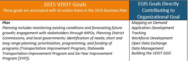
37 Case Study: Virginia Department of Transportation

38 Case Study: Virginia Department of Transportation Mission: Our mission is to plan, deliver, operate and maintain a transportation system that is safe, enables easy movement of people and goods, enhances the economy and improves our quality of life. Plan Deliver Operate Maintain Support
39
40 Case Study: State of Tennessee

41 Case Study: State of TN After years of limited training budgets, many organizations now face the challenge of aligning employee skills with modern technology-driven workflows and customer service expectations. A big focus of the GIS leadership at the State was ensuring that the training went to the right people in the right classes and really showed the impact and the business benefits of the training.
42 Case Study OLG Safety OIR State of TN Military TWRA TDOT


43 Case Study TDOT GIS Foundation Designing and Sharing Data Management Recommended Courses - ArcGIS 2: Essential Workflows - ArcGIS 4: Sharing Content on the Web - Designing Maps with ArcGIS - Configuring and Managing the Multi-User Geodatabase - Working with CAD Data in ArcGIS - ArcGIS Online Subscriptions for Organizations: Publisher Workflows


44 Please Take Our Survey on the Esri Events App! Download the Esri Events app and find your event Select the session you attended Scroll down to find the survey Complete Answers and Select Submit

45
Workforce Development Enables Your Adoption Strategy
 Workforce Development Enables Your Adoption Strategy Michael Green Organizational Adoption Consultant Matthew Karl Training Consultant Agenda Adopt, Embrace, Utilize Components of Change Management Workforce
No. of Days. ArcGIS 3: Performing Analysis ,431. Building 3D cities Using Esri City Engine ,859
 What s New? Creating Story Maps with ArcGIS Field Data Collection and Management Using ArcGIS Get Started with Insights for ArcGIS Introduction to GIS Using ArcGIS & ArcGIS Pro: Essential Workflow Migrating
No. of Days. ArcGIS Pro for GIS Professionals ,431. Building 3D cities Using Esri City Engine ,859
 What s New? Creating Story Maps with ArcGIS Field Data Collection and Management Using ArcGIS Get Started with Insights for ArcGIS Introduction to GIS Using ArcGIS & ArcGIS Pro: Essential Workflow Migrating
No. of Days. Building 3D cities Using Esri City Engine ,859. Creating & Analyzing Surfaces Using ArcGIS Spatial Analyst 1 7 3,139
 Q3 What s New? Creating and Editing Data with ArcGIS Pro Editing and Maintaining Parcels Using ArcGIS Spatial Analysis Using ArcGIS Pro User Workflows for ArcGIS Online Organizations Q3-2018 ArcGIS Desktop
ArcGIS is Advancing. Both Contributing and Integrating many new Innovations. IoT. Smart Mapping. Smart Devices Advanced Analytics
 ArcGIS is Advancing IoT Smart Devices Advanced Analytics Smart Mapping Real-Time Faster Computing Web Services Crowdsourcing Sensor Networks Both Contributing and Integrating many new Innovations ArcGIS
ArcGIS. for Server. Understanding our World
 ArcGIS for Server Understanding our World ArcGIS for Server Create, Distribute, and Manage GIS Services You can use ArcGIS for Server to create services from your mapping and geographic information system
Esri User Conference 2018 Video Topics
 Esri User Conference 2018 Video Topics 3D GIS 3D Across ArcGIS 3D Analysis Tools in ArcGIS Pro 3D Cartographic Techniques: An Introduction 3D Data: Lidar Point Clouds and 3D Mesh 3D Feature and Sub-Surface
Esri Training by Microcenter Prepare to Innovate. Microcenter Course Catalog
 Esri Training by Microcenter Prepare to Innovate 2015 Instructor-Led Courses Microcenter Course Catalog ArcGIS Foundational Courses Designed to meet the learning needs of professionals whose GIS experience
Portal for ArcGIS: An Introduction. Catherine Hynes and Derek Law
 Portal for ArcGIS: An Introduction Catherine Hynes and Derek Law Agenda Web GIS pattern Product overview Installation and deployment Configuration options Security options and groups Portal for ArcGIS
ArcGIS Enterprise: What s New. Philip Heede Shannon Kalisky Melanie Summers Sam Williamson
 ArcGIS Enterprise: What s New Philip Heede Shannon Kalisky Melanie Summers Sam Williamson ArcGIS Enterprise is the new name for ArcGIS for Server What is ArcGIS Enterprise ArcGIS Enterprise is powerful
Introduction to Portal for ArcGIS. Hao LEE November 12, 2015
 Introduction to Portal for ArcGIS Hao LEE November 12, 2015 Agenda Web GIS pattern Product overview Installation and deployment Security and groups Configuration options Portal for ArcGIS + ArcGIS for
Web GIS Administration: Tips and Tricks
 EdUC 2017 July 8 th, 2017 Web GIS Administration: Tips and Tricks Geri Miller Agenda Concerns Acknowledged User Management Content Management Monitoring Licensing and logins Sophistication of IT support
Creating a Staff Development Plan with Esri
 Creating a Staff Development Plan with Esri Michael Green David Schneider Guest Presenter: Shane Feirer, University of California Esri UC 2014 Technical Workshop Agenda What is a Staff Development Plan?
OFWIM 2017 Annual Conference What Does Web GIS Really Mean for Fish and Wildlife Agencies?
 Content Open Mapping OFWIM 2017 Annual Conference What Does Web GIS Really Mean for Fish and Wildlife Agencies? Imagery Spatial Analysis Mike Bialousz, Esri 3D Data Exploration Real-Time Apps Visualization
ArcGIS Data Reviewer: Assessing Positional Accuracy. Roslyn Dunn
 ArcGIS Data Reviewer: Assessing Positional Accuracy Roslyn Dunn What is ArcGIS Data Reviewer? Data Quality Management for ArcGIS Provides - Rule-based validation - Interactive tools - Track errors Validate
Data Aggregation with InfraWorks and ArcGIS for Visualization, Analysis, and Planning
 Data Aggregation with InfraWorks and ArcGIS for Visualization, Analysis, and Planning Stephen Brockwell President, Brockwell IT Consulting, Inc. Join the conversation #AU2017 KEYWORD Class Summary Silos
ArcGIS for INSPIRE. Marten Hogeweg Satish Sankaran
 ArcGIS for INSPIRE Marten Hogeweg Satish Sankaran Outline What is ArcGIS ArcGIS for INSPIRE Web GIS Case Studies Roadmap Q&A What is INSPIRE? INSPIRE is the legal framework for a European Spatial Data
Introduction to Portal for ArcGIS
 Introduction to Portal for ArcGIS Derek Law Product Management March 10 th, 2015 Esri Developer Summit 2015 Agenda Web GIS pattern Product overview Installation and deployment Security and groups Configuration
Portal for ArcGIS: An Introduction
 Portal for ArcGIS: An Introduction Derek Law Esri Product Management Esri UC 2014 Technical Workshop Agenda Web GIS pattern Product overview Installation and deployment Security and groups Configuration
CHAPTER 22 GEOGRAPHIC INFORMATION SYSTEMS
 CHAPTER 22 GEOGRAPHIC INFORMATION SYSTEMS PURPOSE: This chapter establishes the administration and use of to improve the quality and accessibility of Department s spatial information and support graphical
Esri and GIS Education
 Esri and GIS Education Organizations Esri Users 1,200 National Government Agencies 11,500 States & Regional Agencies 30,800 Cities & Local Governments 32,000 Businesses 8,500 Utilities 12,600 NGOs 11,000
Leveraging Web GIS: An Introduction to the ArcGIS portal
 Leveraging Web GIS: An Introduction to the ArcGIS portal Derek Law Product Management DLaw@esri.com Agenda Web GIS pattern Product overview Installation and deployment Configuration options Security options
Introduction to ArcGIS Maps for Office. Greg Ponto Scott Ball
 Introduction to ArcGIS Maps for Office Greg Ponto Scott Ball Agenda What is Maps for Office? Platform overview What are Apps for the Office? ArcGIS Maps for Office features - Visualization - Geoenrichment
Esri Eastern Afica Training
 Esri Eastern Afica Training 2018-2019 Your Location for Lifelong Learning Instructor-Led Courses Training Catalog Introduction Introduction Esri training options teach GIS problem-solving skills and best
Geography for the 2020 Round of Census
 Boundaries Key Census Data EA Id Population Male Female EA Id Area EA Id Num HH Avg HH size Geography for the 2020 Round of Census Linda Peters, Esri lpeters@esri.com Integration of Statistical and Geospatial
The Platform Generation. Derek Law and Ebony Wicks
 The Platform Generation Derek Law and Ebony Wicks GIS Provides the Framework and Process For Applying Geography Analysis and Interpretation Design and Planning Creating Understanding Modeling and Predicting
Enabling ENVI. ArcGIS for Server
 Enabling ENVI throughh ArcGIS for Server 1 Imagery: A Unique and Valuable Source of Data Imagery is not just a base map, but a layer of rich information that can address problems faced by GIS users. >
Esri Training Your Location for Lifelong Learning. Instructor-Led Courses Esri Course Catalog
 Esri Training 2017 2018 Your Location for Lifelong Learning Instructor-Led Courses Esri Course Catalog Find Out More about Esri Training For the latest class schedules and detailed course information and
ArcGIS Deployment Pattern. Azlina Mahad
 ArcGIS Deployment Pattern Azlina Mahad Agenda Deployment Options Cloud Portal ArcGIS Server Data Publication Mobile System Management Desktop Web Device ArcGIS An Integrated Web GIS Platform Portal Providing
ArcGIS Online Routing and Network Analysis. Deelesh Mandloi Matt Crowder
 ArcGIS Online Routing and Network Analysis Deelesh Mandloi Matt Crowder Introductions Who are we? - Members of the Network Analyst development team Who are you? - Network Analyst users? - ArcGIS Online
Web GIS: Architectural Patterns and Practices. Shannon Kalisky Philip Heede
 Web GIS: Architectural Patterns and Practices Shannon Kalisky Philip Heede Web GIS Transformation of the ArcGIS Platform Desktop Apps Server GIS Web Maps Web Scenes Layers Web GIS Transformation of the
The Pace of Change Is Accelerating Creating Many Challenges
 VISION The Pace of Change Is Accelerating Creating Many Challenges Evidence Threatening Our Natural World and Our Future as Humans Social Conflict Mass Migration Ocean Acidification Food Population Urbanization
DP Project Development Pvt. Ltd.
 Dear Sir/Madam, Greetings!!! Thanks for contacting DP Project Development for your training requirement. DP Project Development is leading professional training provider in GIS technologies and GIS application
The purpose of this report is to recommend a Geographic Information System (GIS) Strategy for the Town of Richmond Hill.
 Strategy for the Town of Richmond Hill.") Staff Report for Committee of the Whole Meeting Department: Division: Subject: Office of the Chief Administrative Officer Strategic Initiatives SRCAO.18.12 GIS Strategy Purpose: The purpose of this report
Staff Report for Committee of the Whole Meeting Department: Division: Subject: Office of the Chief Administrative Officer Strategic Initiatives SRCAO.18.12 GIS Strategy Purpose: The purpose of this report
ArcGIS Earth for Enterprises DARRON PUSTAM ARCGIS EARTH CHRIS ANDREWS 3D
 ArcGIS Earth for Enterprises DARRON PUSTAM ARCGIS EARTH CHRIS ANDREWS 3D ArcGIS Earth is ArcGIS Earth is a lightweight globe desktop application that helps you explore any part of the world and investigate
Web GIS Patterns and Practices
 FedGIS Conference February 24 25, 2016 Washington, DC Web GIS Patterns and Practices Philip Heede Jay Theodore Witt Mathot Web GIS Transformation of the ArcGIS Platform Desktop Apps Web Maps Web Scenes
Web GIS & ArcGIS Pro. Zena Pelletier Nick Popovich
 Web GIS & ArcGIS Pro Zena Pelletier Nick Popovich Web GIS Transformation of the ArcGIS Platform Desktop Apps GIS Web Maps Web Scenes Layers Evolution of the modern GIS Desktop GIS (standalone GIS) GIS
ArcGIS Data Reviewer: Quality Assessment for Elevation Raster Datasets. Roslyn Dunn
 ArcGIS Data Reviewer: Quality Assessment for Elevation Raster Datasets Roslyn Dunn What is ArcGIS Data Reviewer? Data Quality Management for ArcGIS Provides - Rule-based validation - Interactive tools
The Underutilization of GIS & How to Cure It. Adam Carnow Esri
 The Underutilization of GIS & How to Cure It Adam Carnow Esri What is GIS? A framework to organize, communicate, and understand the science of our world Business Intelligence (BI) is the set of
Web GIS Deployment for Administrators. Vanessa Ramirez Solution Engineer, Natural Resources, Esri
 Web GIS Deployment for Administrators Vanessa Ramirez Solution Engineer, Natural Resources, Esri Agenda Web GIS Concepts Web GIS Deployment Patterns Components of an On-Premises Web GIS Federation of Server
Strategies for Integrating CAD and BIM in ArcGIS. Don Kuehne Esri 3D Product Manager: CAD/BIM/AEC
 Strategies for Integrating CAD and BIM in ArcGIS Don Kuehne Esri 3D Product Manager: CAD/BIM/AEC CAD Digital Drawing CAD in ArcGIS Desktop CAD in Desktop CAD as Data CAD as a Map EXPORT TO CAD Create and
Key Points Sharing fosters participation and collaboration Metadata has a big role in sharing Sharing is not always easy
 Sharing Resources Geoff Mortson esri, Inc. SDI Solutions Team Key Points Sharing fosters participation and collaboration Metadata has a big role in sharing Sharing is not always easy Data Sharing is Good
Spatial Analysis with Web GIS. Rachel Weeden
 Spatial Analysis with Web GIS Rachel Weeden Agenda Subhead goes here Introducing ArcGIS Online Spatial Analysis Workflows Scenarios Other Options Resources ArcGIS is a Platform Making mapping and analytics
ArcGIS Pro Q&A Session. NWGIS Conference, October 11, 2017 With John Sharrard, Esri GIS Solutions Engineer
 ArcGIS Pro Q&A Session NWGIS Conference, October 11, 2017 With John Sharrard, Esri GIS Solutions Engineer jsharrard@esri.com ArcGIS Desktop The applications ArcGIS Pro ArcMap ArcCatalog ArcScene ArcGlobe
Introduction to ArcGIS Server - Creating and Using GIS Services. Mark Ho Instructor Washington, DC
 Introduction to ArcGIS Server - Creating and Using GIS Services Mark Ho Instructor Washington, DC Technical Workshop Road Map Product overview Building server applications GIS services Developer Help resources
June 19 Huntsville, Alabama 1
 June 19 Huntsville, Alabama 1 Real-Time Geospatial Data: The Fusion of PI and ArcGIS Enabling Smarter Facilities Management OSIsoft and Esri Mapping and Location Analytics Platform Supporting Your Use
An introduction to ArcGIS Maps for Office. Scott Ball & Mike Flanagan
 An introduction to ArcGIS Maps for Office Scott Ball & Mike Flanagan Main takeaways for today Adding the where to your analysis You can learn a lot when you unlock the power of geography in your analytics
Ministry of Health and Long-Term Care Geographic Information System (GIS) Strategy An Overview of the Strategy Implementation Plan November 2009
 Strategy An Overview of the Strategy Implementation Plan November 2009") Ministry of Health and Long-Term Care Geographic Information System (GIS) Strategy An Overview of the Strategy Implementation Plan November 2009 John Hill, Health Analytics Branch Health System Information
Ministry of Health and Long-Term Care Geographic Information System (GIS) Strategy An Overview of the Strategy Implementation Plan November 2009 John Hill, Health Analytics Branch Health System Information
TRAITS to put you on the map
 TRAITS to put you on the map Know what s where See the big picture Connect the dots Get it right Use where to say WOW Look around Spread the word Make it yours Finding your way Location is associated with
Innovation. The Push and Pull at ESRI. September Kevin Daugherty Cadastral/Land Records Industry Solutions Manager
 Innovation The Push and Pull at ESRI September 2004 Kevin Daugherty Cadastral/Land Records Industry Solutions Manager The Push and The Pull The Push is the information technology that drives research and
Getting Started with Community Maps
 Esri International User Conference San Diego, California Technical Workshops July 24, 2012 Getting Started with Community Maps Shane Matthews and Tamara Yoder Topics for this Session ArcGIS is a complete
Network Analysis Services in ArcGIS Enterprise. Deelesh Mandloi
 Network Analysis Services in ArcGIS Enterprise Deelesh Mandloi Slides from this demo theater http://esriurl.com/uc17nas Agenda Network Analyst concepts ArcGIS Enterprise publishing workflow - Geoprocessing
Esri Overview for Mentor Protégé Program:
 Agenda Passionate About Helping You Succeed Esri Overview for Mentor Protégé Program: Northrop Grumman CSSS Jeff Dawley 3 September 2010 Esri Overview ArcGIS as a System ArcGIS 10 - Map Production - Mobile
How does ArcGIS Server integrate into an Enterprise Environment? Willy Lynch Mining Industry Specialist ESRI, Denver, Colorado USA
 How does ArcGIS Server integrate into an Enterprise Environment? Willy Lynch Mining Industry Specialist ESRI, Denver, Colorado USA wlynch@esri.com ArcGIS Server Technology Transfer 1 Agenda Who is ESRI?
ArcGIS for INSPIRE. Marten Hogeweg
 ArcGIS for INSPIRE Marten Hogeweg Please Take Our Survey on the App Download the Esri Events app and find your event Select the session you attended Scroll down to find the feedback section Complete answers
Discovery and Access of Geospatial Resources using the Geoportal Extension. Marten Hogeweg Geoportal Extension Product Manager
 Discovery and Access of Geospatial Resources using the Geoportal Extension Marten Hogeweg Geoportal Extension Product Manager DISCOVERY AND ACCESS USING THE GEOPORTAL EXTENSION Geospatial Data Is Very
Incorporating ArcGIS Pro in your Curriculum
 AAG, Boston 2017 April 5, 2017 Incorporating ArcGIS Pro in your Curriculum Geri Miller Agenda Concerns Acknowledged Learning curve ArcGIS Pro does not have all the tools (perception) Licensing and offline
ArcGIS Platform For NSOs
 ArcGIS Platform For NSOs Applying GIS and Spatial Thinking to Official Statistics Esri UC 2014 Demo Theater Applying GIS at the NSO Generic Statistical Business Process Model (GSBPM) 1 Specify Needs 2
ArcGIS Enterprise: Administration Workflows STUDENT EDITION
 ArcGIS Enterprise: Administration Workflows STUDENT EDITION Copyright 2019 Esri All rights reserved. Course version 1.1. Version release date April 2019. Printed in the United States of America. The information
Network Analysis with ArcGIS Online. Deelesh Mandloi Dmitry Kudinov
 Deelesh Mandloi Dmitry Kudinov Introductions Who are we? - Network Analyst Product Engineers Who are you? - Network Analyst users? - ArcGIS Online users? - Trying to figure out what is ArcGIS Online? Slides
ArcGIS Urban: An Introduction. Lisa Staehli ArcGIS Urban Team Product Development Brooks Patrick ArcGIS Urban Team Business Development
 ArcGIS Urban: An Introduction Lisa Staehli ArcGIS Urban Team Product Development Brooks Patrick ArcGIS Urban Team Business Development Our Cities Are Facing Massive Challenges Our Cities Are Facing Massive
FIRE DEPARMENT SANTA CLARA COUNTY
 DEFINITION FIRE DEPARMENT SANTA CLARA COUNTY GEOGRAPHIC INFORMATION SYSTEM (GIS) ANALYST Under the direction of the Information Technology Officer, the GIS Analyst provides geo-spatial strategic planning,
Leveraging ArcGIS Server Technology
 Leveraging ArcGIS Server Technology A Local Government Approach Virginia Johnston GIS Systems Analyst Virginia Beach 39 th Largest city in the United States 438,000 Residents City by the Sea Located in
GIS Capability Maturity Assessment: How is Your Organization Doing?
 GIS Capability Maturity Assessment: How is Your Organization Doing? Presented by: Bill Johnstone Principal Consultant Spatial Vision Group November 8, 2018 1. Motivation for Capability Maturity Models
ArcGIS for Desktop. ArcGIS for Desktop is the primary authoring tool for the ArcGIS platform.
 ArcGIS for Desktop ArcGIS for Desktop ArcGIS for Desktop is the primary authoring tool for the ArcGIS platform. Beyond showing your data as points on a map, ArcGIS for Desktop gives you the power to manage
Leveraging ArcGIS Online Elevation and Hydrology Services. Steve Kopp, Jian Lange
 Leveraging ArcGIS Online Elevation and Hydrology Services Steve Kopp, Jian Lange Topics An overview of ArcGIS Online Elevation Analysis Using Elevation Analysis Services in ArcGIS for Desktop Using Elevation
What Would John Snow Do (Today)? Part 1
? Part 1") What Would John Snow Do (Today)? Part 1 Tanya Bigos and Derek Law @Tanyabigos @GIS_Bandit Thurs Oct 19 th, 2017 Outline Overview of the ArcGIS Platform Whiteboard discussion Summary Questions A Whole New
What Would John Snow Do (Today)? Part 1 Tanya Bigos and Derek Law @Tanyabigos @GIS_Bandit Thurs Oct 19 th, 2017 Outline Overview of the ArcGIS Platform Whiteboard discussion Summary Questions A Whole New
JOB DESCRI PTI ON. GIS Administrator
 JOB DESCRI PTI ON JOB GRADE: GS-0 Cla ss Code : Office - 8 8 0 DEPARTMENT: 2 0 - FLSA: EXEMPT JOB NO: 6-0 9-2 7 SALARY: To Be De t e rm in e d Job description statements are intended to describe the general
Experiences and Directions in National Portals"
 FIG Seminar on e-land Administration Innsbruck/Austria 2-4 June 2004 "ESRI's Experiences and Directions in National Portals" Kevin Daugherty Cadastral/Land Records Manager ESRI Topic Points Technology
ESRI Delivering geographic information systems to millions of users
 Using Web GIS to Track Government Spending and Performance Eric Floss - ESRI April 12, 2010 ESRI Delivering geographic information systems to millions of users GIS Is Changing Everything How We Reason
ELF products in the ArcGIS platform
 ELF products in the ArcGIS platform Presentation to: Author: Date: NMO Summit 2016, Dublin, Ireland Clemens Portele 18 May 2016 The Building Blocks 18 May, 2016 More ELF users through affiliated platforms
CHARTING SPATIAL BUSINESS TRANSFORMATION
 CHARTING SPATIAL BUSINESS TRANSFORMATION An in-depth look at the business patterns of GIS and location intelligence adoption in the private sector EXECUTIVE SUMMARY The global use of geographic information
You are Building Your Organization s Geographic Knowledge
 You are Building Your Organization s Geographic Knowledge And Increasingly Making it Available Sharing Data Publishing Maps and Geo-Apps Developing Collaborative Approaches Citizens Knowledge Workers Analysts
Arcmap Manual Esri 10 READ ONLINE
 Arcmap Manual Esri 10 READ ONLINE If searching for a book Arcmap manual esri 10 in pdf form, then you have come on to the loyal site. We present the utter release of this book in PDF, doc, DjVu, epub,
Esri WebGIS Highlights of What s New, and the Road Ahead
 West Virginia GIS Conference WVU, Morgantown, WV Esri WebGIS Highlights of What s New, and the Road Ahead Mark Scott, Solutions Engineer, Esri Local Government Team May 5 th, 2016 West Virginia GIS Conference
The Emerging Role of Enterprise GIS in State Forest Agencies
 The Emerging Role of Enterprise GIS in State Forest Agencies Geographic Information System (GIS) A geographic information system (GIS) is a computer software system designed to capture, store, manipulate,
Workshop and Session Descriptions
 MONDAY, SEPTEMBER 14 Workshops (Full-day) Workshop and Session Descriptions 1. Bridging the surveyed gap: How land surveying data works with GIS GIS professionals use a myriad of data to construct their
Ready for INSPIRE.... connecting worlds. European SDI Service Center
 Ready for INSPIRE Consultancy SOFTWARE T r a i n i n g Solutions... connecting worlds European SDI Service Center Increasing Added Value with INSPIRE and SDI Components INSPIRE In 2007, the European Commission
ArcGIS Enterprise: What s New. Philip Heede Shannon Kalisky Melanie Summers Shreyas Shinde
 ArcGIS Enterprise: What s New Philip Heede Shannon Kalisky Melanie Summers Shreyas Shinde ArcGIS Enterprise is the new name for ArcGIS for Server ArcGIS Enterprise Software Components ArcGIS Server Portal
ESRI Survey Summit August Clint Brown Director of ESRI Software Products
 ESRI Survey Summit August 2006 Clint Brown Director of ESRI Software Products Cadastral Fabric How does Cadastral fit with Survey? Surveyors process raw field observations Survey measurements define high-order
ESRI INC. NEWS SPECIAL PROJECTS GIS TRAINING COURSES MICROCENTER NEWS GIS WORKSHOP. GIS e-newsletter
 GIS e-newsletter July 2018 CONTENTS 03 05 06 08 10 Esri User Conference 2018 Esri ebooks GIS Workshop - Adoption of Cloud Based Enterprise GIS - Challenges & Solutions MicroCenter s MCA ebiz ERP Wins New
Enabling Web GIS. Dal Hunter Jeff Shaner
 Enabling Web GIS Dal Hunter Jeff Shaner Enabling Web GIS In Your Infrastructure Agenda Quick Overview Web GIS Deployment Server GIS Deployment Security and Identity Management Web GIS Operations Web GIS
Data Aggregation with InfraWorks and ArcGIS for Visualization, Analysis, and Planning
 CI125230 Data Aggregation with InfraWorks and ArcGIS for Visualization, Analysis, and Planning Stephen Brockwell Brockwell IT Consulting Inc. Sean Kinahan Brockwell IT Consulting Inc. Learning Objectives
Changes in Esri GIS, practical ways to be ready for the future
 Changes in Esri GIS, practical ways to be ready for the future John Sharrard, Esri April 16, 2015 The only thing that is constant is change. Heraclitus, ca. 500 B.C. My story (of experiencing change) Changes
How to Increase the Significance of your GIS
 How to Increase the Significance of your GIS Wade Kloos, GIS Director, Utah Department of Natural Resources wkloos@utah.gov 2014 Esri International User Conference July 17 How to Increase the Significance
JOB TITLE: CURRENT CLASSIFICATION/GRID POSITION # GIS Coordinator AD Grid Level 6(c) # 420
 # 420") COUNTY OF GRANDE PRAIRIE JOB DESCRIPTION JOB TITLE: CURRENT CLASSIFICATION/GRID POSITION # GIS Coordinator AD Grid Level 6(c) # 420 NOC CODE: 2255 STANDARD HOURS: 35 hours/week (non-management) JOB TITLE
COUNTY OF GRANDE PRAIRIE JOB DESCRIPTION JOB TITLE: CURRENT CLASSIFICATION/GRID POSITION # GIS Coordinator AD Grid Level 6(c) # 420 NOC CODE: 2255 STANDARD HOURS: 35 hours/week (non-management) JOB TITLE
Road Ahead: Linear Referencing and UPDM
 Road Ahead: Linear Referencing and UPDM Esri European Petroleum GIS Conference November 7, 2014 Congress Centre, London Your Work Making a Difference ArcGIS Is Evolving Your GIS Is Becoming Part of an
Arcmap Manual Esri 10 READ ONLINE
 Arcmap Manual Esri 10 READ ONLINE Esri Store: Browsing ArcPad 10.2.2 - ArcPad is mobile field mapping and data collection software designed for GIS professionals. It includes advanced GIS and GPS capabilities
GIS ADMINISTRATOR / WEB DEVELOPER EVANSVILLE-VANDERBURGH COUNTY AREA PLAN COMMISSION
 GIS ADMINISTRATOR / WEB DEVELOPER EVANSVILLE-VANDERBURGH COUNTY AREA PLAN COMMISSION SALARY RANGE INITIATION $43,277 SIX MONTHS $45,367 POSITION GRADE PAT VI The Evansville-Vanderburgh County Area Plan
Demystifying ArcGIS Online. Karen Lizcano Esri
 Demystifying ArcGIS Online Karen Lizcano Esri An Integrated Web GIS Platform Desktop Web Device Powered by Services Managed via Portal Access from any Device Portal Server Online Content and Services ArcGIS
INSPIRE Shared Service
 INSPIRE Shared Service Creation and operation out of the box Petra Fritz (HZD), Michael Voigtländer (Esri Deutschland GmbH) INSPIRE Shared Service Agenda HZD backbone for a geodata infrastructure Implementing
October 2011 ArcGIS 10 for Server Functionality Matrix
 October 2011 ArcGIS 10 for Server Functionality Matrix Esri, 380 New York St., Redlands, CA 92373-8100 USA TEL 909-793-2853 FAX 909-793-5953 E-MAIL info@esri.com WEB www.esri.com Copyright 2011 Esri All
DATA SCIENCE SIMPLIFIED USING ARCGIS API FOR PYTHON
 DATA SCIENCE SIMPLIFIED USING ARCGIS API FOR PYTHON LEAD CONSULTANT, INFOSYS LIMITED SEZ Survey No. 41 (pt) 50 (pt), Singapore Township PO, Ghatkesar Mandal, Hyderabad, Telengana 500088 Word Limit of the
ArcGIS Pro: Analysis and Geoprocessing. Nicholas M. Giner Esri Christopher Gabris Blue Raster
 ArcGIS Pro: Analysis and Geoprocessing Nicholas M. Giner Esri Christopher Gabris Blue Raster Agenda What is Analysis and Geoprocessing? Analysis in ArcGIS Pro - 2D (Spatial xy) - 3D (Elevation - z) - 4D
ArcGIS 10.1 An Overview of the System
 ArcGIS 10.1 An Overview of the System ArcGIS 10.1 An Overview of the System Damian Spangrud Director of Solutions, Esri Redlands, CA USA ArcGIS 10.1 Web Cloud Online Mobile Enterprise Desktop ArcGIS 10.1
Administering your Enterprise Geodatabase using Python. Jill Penney
 Administering your Enterprise Geodatabase using Python Jill Penney Assumptions Basic knowledge of python Basic knowledge enterprise geodatabases and workflows You want code Please turn off or silence cell
Houston Plat Tracker puts the GIS in Land Development
 Houston Plat Tracker puts the GIS in Land Development Abstract: The Plat Tracker supports Houston's land development approval process. This home grown web-based system includes GIS research tools and a
The University of Arizona Enterprise GIS. CFTA 2016 Facilities Geospatial Technologies Showcase
 The University of Arizona Enterprise GIS CFTA 2016 Facilities Geospatial Technologies Showcase Main Campus: Tucson, Arizona Founded: 1885 Number of Buildings: 227 GSF: 9.4 million Acres: 393 Total Students:
A Vision for ArcGIS Applying Geography Everywhere
 A Vision for ArcGIS Applying Geography Everywhere WELCOME PURPOSE A Network of GIS Professionals Are Awakening the World to the Power of Web GIS You Your WORK Making a Difference Your Work Open Maps and
Geodatabase: Best Practices. Robert LeClair, Senior Instructor
 Geodatabase: Best Practices Robert LeClair, Senior Instructor Agenda Geodatabase Creation Data Ownership Data Model Data Configuration Geodatabase Behaviors Data Validation Extending Performance Geodatabase