Reflections on Sandy: Understanding What Just Happened & Where Do We Go From Here?
|
|
|
- Stuart Scott
- 6 years ago
- Views:
Transcription

1 Reflections on Sandy: Understanding What Just Happened & Where Do We Go From Here? Gary Szatkowski Philadelphia/Mount Holly, NJ Office x222

2 Mount Holly NJ The area we serve is shaded in green 34 counties in four states Over 11 million people We issue weather, water & climate forecasts & warnings for the protection of life & property, and to enhance the national economy.

3 Sandy what happened
4 Performance NWS Mount Holly began issuing briefing packages on Tuesday, October 23 rd Weather watches were issued +/- 55 hours before event. Weather warnings issued +/- 40 hours before event Partner performance excellent media coverage

5 Recognition NWS Mount Holly (including me) recognized as Hurricane Sandy Hero by Newark Star-Ledger
6 Partner performance Excellent leadership by Governors of New Jersey & Delaware They called evacuations when they needed to Excellent communication by state, county & local emergency managers They said and did the right things. Messaging was consistent all through the run-up to the event.
7 How were the results? Let s look briefly at the physical results Then spend some time talking about the other results.

8 Atlantic City
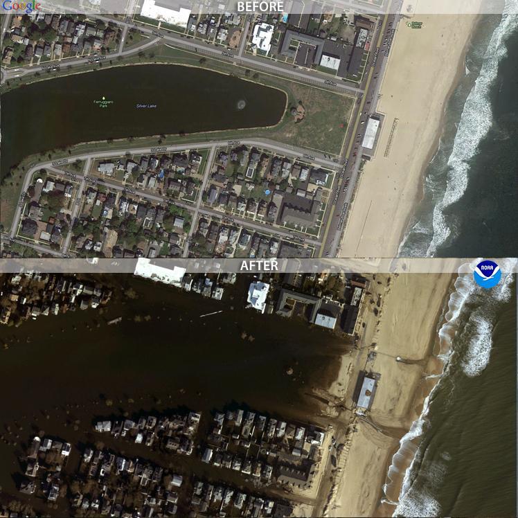
9
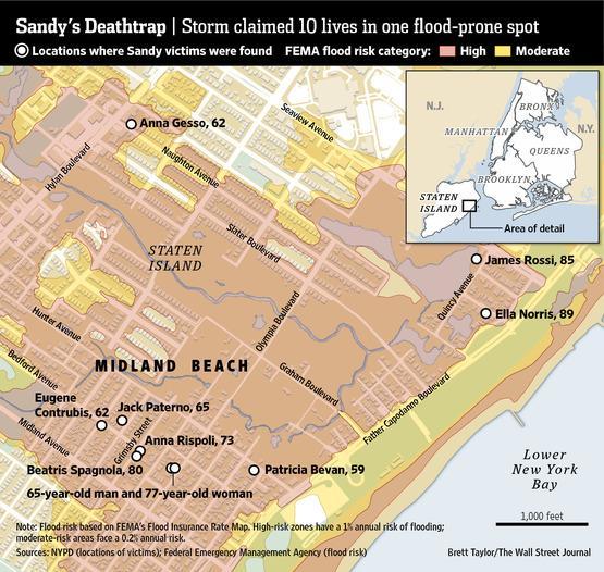
10
11
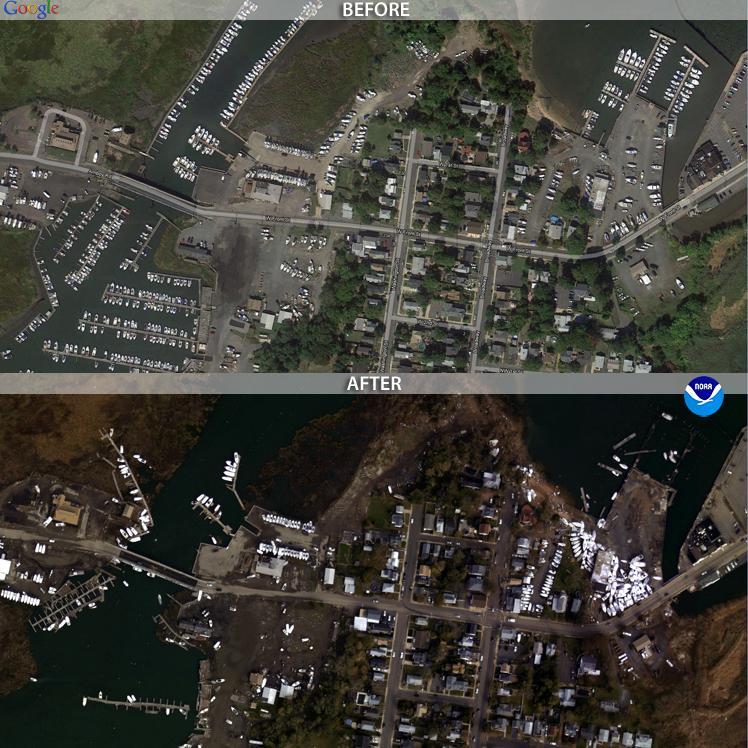
12 Mantoloking Barrier Island Breach!

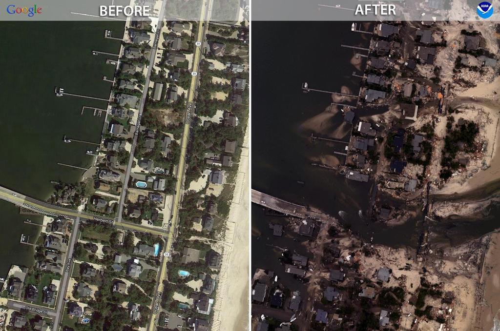
13 Normandy Beach, NJ
14 Summary slide of Sandy impacts 253 deaths total 131 in the United States, 104 in Haiti, 11 in Cuba, 2 in Bahamas, 2 in Canada, 2 in Dominican Republic, 1 in Jamaica $65+ billion in damages $63 billion in United States All figures are still under review.

15 Hurricane Sandy
16 Sandy Where do we go from here Photo on previous page was a nighttime image that looks as clear as our old visible satellite imagery Our technical tools are outstripping our ability to get people to understand what they need to do

17 Fatalities Any fatality is one too many. But we have fatality hotspots from coastal flooding Why? Graphic courtesy NY Times

18 Analysis of fatalities in the United States
19 Decisions made Saturday before Sandy landfall on Monday NJ Governor quotes Saturday morning declares State of Emergency and mandatory evacuations: We are looking at hurricane force winds. It is simply unsafe for people to be there [evacuation zones]. NYC Mayor quotes Saturday afternoon press conference explaining why no evacuations are being ordered: "We're making that decision based on the nature of this storm. Although we're expecting a large surge of water, it is not expected to be a tropical storm or a hurricane-type surge," he said. "With this storm we'll likely see a slow pileup of water, rather than a sudden surge, which is what you would expect from a hurricane and which we saw with Irene 14 months ago.
20 Things to focus on regarding coastal flooding for the Atlantic Coast, lower Delaware Bay & Raritan Bay We are now completing our third high tide cycle with Hurricane Sandy. This high tide cycle was very destructive with major to record coastal flooding occurring. The next high tide cycle will be even worse along the Atlantic Coast where Sandy comes ashore as well as points further north. The Atlantic Coast of New Jersey and the Raritan Bay will see even higher coastal flooding on this evening s high tide, at record levels. Any shift of the storm track further south will bring higher coastal flooding levels to the Atlantic Coast of Delaware and the Delaware Bay. Dangerous wave action will combine with the coastal flooding. 12 to 20 foot breakers will occur in the surf zone for the remainder of today and into tonight. The barrier islands will be cut off from the mainland. Breaches in the barrier islands will likely occur during this evening s high tide, as the center of Sandy approaches. Water is the most life threatening aspect of this storm. Hurricane Sandy is already the deadliest hurricane of the 2012 season. Please respect its power and heed the advice of local and state officials regarding any evacuations.
21 Barrier island breach! Mantoloking NJ

22 In extreme events, experience fails. NJ Transit put equipment valued $385 million in a location that did not flood during Hurricane Floyd & Hurricane Irene Kearny, NJ 9 feet above MSL vs. storm tide feet
23 Are we learning? Philadelphia Inquirer 12/04/ Statement by NJ Transit Director projections from the NWS forecast at the time the system shutdown called for only a 10 to 20 percent chance of flooding at the [Kearny] railyards. If you on Twitter, you saw my reaction. Statement by ex-nj Transit chief of staff in opinion piece explaining why NJ Transit should not be criticized. NorthJersey.com 12/04/2012 opinion piece Weather forecasting not an exact science NJ.com 12/05/2012 opinion piece Sandy weather forecast was wrong. Why is this being said? NJ Transit has to testify before US Senate on 12/06/2012 on loss of rail cars NJ Transit has to testify before NJ Assembly on 12/10/2012 on loss of rail cars. NJ Transit testimony stressed listening & use of NWS information in the run-up to Sandy. NJ Transit railyards which flooded were considered not in flood zone.

24 USACE map 2010 Light gray shading floods with Category I storm surge 6 to 9 feet.
 is possible in the Raritan Bay. This would produce record coastal flooding.")
 is possible in the Chesapeake Bay based on where the storm center comes ashore.")
25 Coastal flooding tools Major coastal flooding is expected based on the current track forecast. Record coastal flooding is likely. A 12 to 15 foot storm tide (surge + astronomical tide) is possible in the Raritan Bay. This would produce record coastal flooding. A 10 to 12 foot storm tide is possible along the Atlantic Coast & the Delaware Bay. This would result in record coastal flooding in many locations. A 3 to 5 foot storm tide (surge + astronomical tide) is possible in the Chesapeake Bay based on where the storm center comes ashore. This would produce moderate coastal flooding.
26 Storm surge forecast from NHC issued 1100 AM Sunday October 28th Maximum surge forecast for Monday night
27 Port Authority NY/NJ No one believed there could be a 13-foot storm surge ever in this port and there was, said retired Rear Admiral Rick Larrabee, director of Port Commerce for the Port Authority of New York and New Jersey. I talked to people who have worked here for 30 years who said they never feared for their lives but they did that night. What they actually got was about an 8 to 10 foot storm surge. Forecast surge on Saturday 4 to 8 feet for Mon Forecast surge on Sunday 6 to 11 feet on Mon The price for this decision-making: Larrabee said the storm surge enveloped 14,000 new cars on the docks on the New Jersey side of the Hudson, incapacitated 40 percent of the 50 gargantuan cargo cranes that stand several stories high and took out 2,500 trucks critical to moving freight off the docks.

28 Light gray shading floods with Category I storm surge 6 to 10 feet. USACE map 2010

29 Palisades Medical Center Did not evacuate during Sandy until flooding began at their facility & they lost emergency power; despite forecast of 6 to 11 feet storm surge. The Medical Center was able to evacuate 83 patients to Hackensack Medical Center, including 13 that were on life support, according to township spokesman Swibinski. The effort was coordinated by the North Bergen Police Department along with EMS and McCabe ambulance NJ.com report Did evacuate for Hurricane Irene; water got into their parking lot but did not flood the facility at that time, experienced storm surge of 4 to 5 feet. Experience issue? Other factors?
30
31 Wall Street Journal article Fearing a flood, Mr. Bediner drove his family out of Midland Beach at about noon on Monday. Many of his neighbors stayed. As wind and rain intensified on Monday afternoon, the mood in the neighborhood was still upbeat. "We were out there joking, saying, 'They hyped Irene so much, and what'd we get? A little water,' " recalled Laura Gatti. About three-quarters of her immediate neighbors decided to weather the storm in their homes. Many recalled that Tropical Storm Irene in 2011 had turned out to be less fierce than predicted, and some worried about looting if they left.

32 Dune or not to Dune that is the question Philadelphia Inquirer 12/03/2012 Showdown at the Shore: More dunes or fewer? And who pays?
33 Sandy Where do we go from here These are not hard science issues These are not labeling issues Was it a hurricane when it made landfall? Or not? Should hurricane warnings have been in place? NJ Transit made decisions based on previous hurricane experience So did the people who died in Staten Island (WSJ report) These are social science issues Because we have gotten so good at the hard science
34 Wharton report November 2012 Report itself questioning seems biased against NWS decision-making process for Sandy. Refers to warnings we did issue as a cacophony. Bad news almost endless. Problems with risk messaging Problems with risk assessment Problems with actions taken in response to perceived risk.
35 Problems with risk messaging Report suggests that lack of hurricane warnings vs. cacophony of other type of warnings (coastal flood, high wind, etc.) produced confusion about exact threat they faced. My thoughts I m not completely buying this, & survey seems to be fishing for this result. People clearly knew something was coming and it posed some type of hazard.
36 Problems with risk assessment Even residents who lived within a block of the water where flooding would have been the largest threat posed by the storm saw the greatest threat posed by Sandy as coming from winds, not water. Look at the numbers regarding flooding from rainfall! My thoughts These results are based on experience. The damage most widely seen is wind.
37 Problems with risk assessment 76% of survey had experienced living through a hurricane Of those who experienced Irene, only 37% reported suffering any damage from the storm. My observation if you haven t experienced damage or other significant problems (prolonged power outage), you haven t experienced a hurricane
38 Problems with actions taken based on perceived risk If you can t envision it, you probably aren t prepared to deal with it. If you don t see storm surge as a big risk (even if you can see the ocean), you are at substantial risk to not make a good decision. In the absence of the ability to envision, we substitute experience (e.g., the railyard hasn t flooded during previous hurricanes )
39 Story about person & co-workers Person works in small store in mid-town Manhattan Person didn t experience Hurricane Irene; co-workers did. Asked what to expect with Sandy, was told: You get one to two days off Some wind; some rain. Power may go off. May want to pick up some water, a bottle of wine. My conclusion: It s a snow day, expect change the snow to wind & rain. Why would they say this? Because they experienced Hurricane Irene, and this is what happened. This is the challenge. Until you can understand what will likely happen, you cannot be prepared.
40 Factoring In Climate Change Did climate change make Sandy worse? Sure it did. Sea level is rising, and coastal flooding was worse as a result. Did climate change cause Hurricane Sandy? No, of course not. We have a long history of Hurricanes Will climate change cause more storms like Sandy? Possibly.
41
42


43 Sea level continues to rise
44 Greenland will contribute more to sea level rise in the future
45 Atlantic City rising more than 1 foot per 100 years
46 Cape May NJ sea level rise accelerating
47 The problem When we lack vision, or exceed our ability to envision an extreme possibility, we fall back on experience This tendency to favor experience limits us to things which can be seen and understood over an average human s adult life span roughly 50 years. Bad news if you re facing a 100 year or 500 year storm This problem is exacerbated when climate changes extreme weather e.g., sea level is higher, or heavy rainfall more likely.
48 The problem long term In the long term, we as a species will have to discuss/decide what kind of world we want 100 years from now. Climate change is driven primarily by greenhouse gas emissions. We have to decide what tradeoffs we want to make. And that is all I m going to say about that, for that is a political leadership challenge.
49 The problem short term The problem in the short term (5 to 50 years) is that we have already built into the system the changes we are going to see The planet is NOT in equilibrium. If we ceased emitting greenhouse gases right this minute, the planet would still get warmer, seas would continue to rise. Why? Because we are NOT in equilibrium. Automobile analogy Press harder on accelerator, you go faster, Press less on the accelerator, you go slower. Take foot off the gas, you will keep rolling for awhile before coming to a stop. In all scenarios, you are not where you started. Climate will change, the only question is how much?
50 The problem short term So, no matter what we do, climate will change over the next 50 years. Warmer temperatures, rising sea level, etc. The ability for our experience to mislead us will continue to grow.
51 Sandy Where do we go from here A ray of hope our ability to forecast the weather in the next 7 to 10 day time range will continue to improve, enhancing our potential ability to respond to all weather threats. It is clear to me that the value of our weather forecasts has improved to such a degree that the bigger problem has become getting people to understand the impacts of a weather forecast. We have a lot of hard work ahead of us in getting people to understand and fully leverage the information available to them when dealing with very low frequency, very high impact natural hazard events. Perhaps a model children & crossing a street Most importantly, we have been reminded by Mother Nature that the world is a dangerous place. During Hurricane Sandy, some paid a terrible price for us to re-learn this truth. For their sake & ours, let s not ever forget it.
52 Questions? Comments?
Very Dangerous Coastal Storm Sandy October 28 th 31 st 2012
 Very Dangerous Coastal Storm Sandy October 28 th 31 st 2012 Prepared 600 PM EDT Monday October 29, 2012 Gary Szatkowski NOAA s NJ Forecast Office Weather.gov/phi Purpose of Briefing Briefing #11 for event
Hurricane Sandy October 28 th 31 st 2012
 Hurricane Sandy October 28 th 31 st 2012 Prepared 530 PM EDT Saturday October 27, 2012 Gary Szatkowski NOAA s NJ Forecast Office Weather.gov/phi Purpose of Briefing Briefing #7 for event Promote situational
Weather briefing Strong Coastal Nor easter November 7 th -8 th, 2012
 Weather briefing Strong Coastal Nor easter November 7 th -8 th, 2012 Prepared 1245 PM EDT Tuesday November 6, 2012 Gary Szatkowski NOAA s NJ Forecast Office Weather.gov/phi Purpose of Briefing Briefing
Major Hurricane Matthew Briefing Situation Overview
 Major Hurricane Matthew Briefing Situation Overview THIS IS NOW A WORST CASE STORM SURGE SCENARIO Catastrophic Damage is Anticipated for Coastal Areas. Major Hurricane Matthew is still expected to move
Weather briefing Strong Coastal Nor easter November 7 th -8 th, 2012
 Weather briefing Strong Coastal Nor easter November 7 th -8 th, 2012 Prepared 1215 PM EDT Wednesday November 7, 2012 Gary Szatkowski NOAA s NJ Forecast Office http://www.erh.noaa.gov/phi/ Purpose of Briefing
Active Weather Threat Halloween Week Nor easter October 28 th 31 st 2012
 Active Weather Threat Halloween Week Nor easter October 28 th 31 st 2012 Prepared 1130 AM EDT Wednesday, October 24, 2012 Gary Szatkowski NOAA s NJ Forecast Office Weather.gov/phi Purpose of Briefing Briefing
Prolonged Coastal Storm October 9 th -12 th, 2013
 Prolonged Coastal Storm October 9 th -12 th, 2013 Prepared 400 PM EDT Tuesday, October 8th, 2013 Gary Szatkowski NOAA s NJ Forecast office http://www.erh.noaa.gov/phi/ Purpose of Briefing Briefing #1 for
Major Hurricane Matthew Briefing Situation Overview
 Major Hurricane Matthew Briefing Situation Overview At 5 p.m. Tuesday, Category 4 Hurricane Matthew was about 860 miles South-Southeast of Mayport, Florida, moving north around 10 mph. Maximum sustained
Active Winter Weather Pattern February 4th-9th
 Active Winter Weather Pattern February 4th-9th Prepared 1230 PM EST Tuesday, February 4, 2014 Gary Szatkowski NOAA s NJ Forecast office http://www.erh.noaa.gov/phi/ Purpose of Briefing Briefing #6 Promote
2017 Hurricane Season and Beyond
 2017 Hurricane Season and Beyond Ken Graham National Hurricane Center Building a Weather-Ready Nation Much of U.S. Coast Saw Tropical Wind Watches or Warnings 2017 Hurricane Season Facts and Figures 7th
NOAA s National Weather Service Philadelphia/Mt. Holly NJ
 Next Briefing Package: Friday, October 2, 2015 no later than 300 PM Hazards and Impacts: Overview: A dangerous weather pattern still threatens our region. Threats include very heavy rainfall, inland river
Nor easter Monday Night Wednesday December 8 10, 2014
 Nor easter Monday Night Wednesday December 8 10, 2014 Prepared 400 PM EST Monday, December 8, 2014 Mitchell Gaines NOAA s Philadelphia/Mount Holly NJ Forecast Office www.weather.gov/phi/ Purpose of Briefing
Hurricane Matthew Threats and Impacts Briefing for Eastern NC
 Hurricane Matthew Threats and Impacts Briefing for Eastern NC October 6 th, 2016 Date/Time Created: 10/6/2016, Noon EDT National Weather Service Newport/Morehead City, NC Hurricane Matthew Key Points Changes
Tropical Storm Harvey: SE Texas Impacts
 Tropical Storm Harvey: SE Texas Impacts 10 AM CDT UPDATE Thursday, August 24, 2017 Prepared by: Dan Reilly, Brian Kyle PLEASE MUTE YOUR LINES AND DON T PUT ON HOLD! Situation Overview Tropical Storm Harvey
HURRICANE IRENE. CONFERENCE CALL BRIEFING SLIDES Saturday August 27, :30 AM
 HURRICANE IRENE CONFERENCE CALL BRIEFING SLIDES Saturday August 27, 2011 8:30 AM NHC TRACK AND CONE HURRICANE IRENE WATCHES/WARNINGS Hurricane Warning along south coast including all of Cape Cod and Islands
Weather Briefing Mixed Winter Storm Event February 26-27, 2013
 Weather Briefing Mixed Winter Storm Event February 26-27, 2013 Prepared 1200 PM EST Tuesday, February 26th, 2013 Joe Miketta NOAA s NJ Forecast Office http://www.erh.noaa.gov/phi/ Purpose of Briefing Briefing
Are You Ready For Hurricane Season? 2018 Hurricane Talk B Y : S T O R M T E A M 8 M E T E O R O L O G I S T J U L I E P H I L L I P S
 Are You Ready For Hurricane Season? 2018 Hurricane Talk B Y : S T O R M T E A M 8 M E T E O R O L O G I S T J U L I E P H I L L I P S About Me I am Currently a Weekday Meteorologist at WFLA Channel 8.
HURRICANE SURVIVAL KIT
 HURRICANE SURVIVAL KIT DEFINITION-A hurricane is a very vast and powerful storm that originates in the tropics of the Atlantic Ocean. They become hurricanes when the sustained winds associated with it
TROPICAL STORM NATE BRIEFING
 TROPICAL STORM NATE BRIEFING 5:00 AM CDT Friday, October 6, 2017 Prepared by: NWS NWSNewOrleans www.weather.gov/neworleans Situation Overview No significant changes to the track forecast this morning.
NOAA s National Weather Service Philadelphia/Mt. Holly NJ
 Next Briefing Package: Thursday, October 1, 2015 no later than 300 PM Hazards and Impacts: Overview: A dangerous weather pattern is developing for our region. Threats include very heavy rainfall, inland
NWS HURRICANES June 3, 2015
 NWS HURRICANES June 3, 2015 Hurricane Season June 1 November 30 2 What s the concern? All tropical systems passing within 125nm of central Maryland since 1950 Mid-Atlantic Hurricanes Greatest Risk: August
2015 Plymouth Rock Assurance New Jersey Hurricane Preparedness Study
 2015 Plymouth Rock Assurance New Jersey Hurricane Preparedness Study About This Study Tropical storms and hurricanes directly and indirectly impact New Jersey and its 130 miles of Atlantic coastline. Although
NOAA s National Weather Service Philadelphia/Mt. Holly NJ
 Snow and Coastal Flooding through this evening Hazards and Impacts: Coastal Flooding: With the persistent onshore flow, and a new moon yesterday, coastal flooding is expected at high tide today. Moderate
NOAA s National Weather Service Philadelphia/Mt. Holly NJ
 Early Week Coastal Flooding and snow Hazards and Impacts: Coastal Flooding: With the persistent onshore flow, and a new moon today, coastal flooding is expected at high tide through Tuesday morning. Moderate
NOAA s National Weather Service Philadelphia/Mt. Holly NJ. Summary. Changes
 Summary A crippling and potentially historic east coast snow storm will lead to blizzard conditions and major coastal flooding for portions of the area this weekend. Changes Blizzard Warning has been expanded
Significant Coastal Storm Today through Thursday, 11/7-8. Weather Briefing
 Significant Coastal Storm Today through Thursday, 11/7-8 Weather Briefing Prepared 10:00 am EST Wednesday, November 7, 2012 Presented by Gary Conte, Warning Coordination Meteorologist NOAA s National Weather
Storm Surge Forecast with Shifting Forecast Tracks
 Storm Surge Forecast with Shifting Forecast Tracks Storm Surge Findings in the Florida Keys Jon Rizzo Warning Coordination Meteorologist National Weather Service Florida Keys Florida Keys Life History
Hurricane Dennis menaces U.S. coast
 www.breaking News English.com Ready-to-use ESL / EFL Lessons Hurricane Dennis menaces U.S. coast URL: http://www.breakingnewsenglish.com/0507/050711-dennis-e.html Today s contents The Article 2 Warm-ups
Donna J. Kain, PhD and Catherine F. Smith, PhD East Carolina University
 Risk Perceptions and Emergency Communication Effectiveness in Coastal Zones Preliminary Findings on Interpretations of Weather Related Messages and Maps Donna J. Kain, PhD (kaind@ecu.edu), and Catherine
Tropical Storm Ana. Created 615 AM Sat May 9, 2015 Reid Hawkins, Science Officer
 Tropical Storm Ana Threat Assessment for northeast South Carolina & southeast North Carolina Created 615 AM Sat May 9, 2015 Reid Hawkins, Science Officer National Weather Service Wilmington, NC 1 New Information
Major Hurricane Earl
 Major Hurricane Earl Advisory 32 North Carolina Threat Assessment Prepared at: 8 AM Thursday September 2, 2010 Hurricane and Tropical Storm Warnings in effect for the North Carolina Coast and Sounds. NWS
GC Briefing. Weather Sentinel Hurricane Florence. Status at 5 PM EDT (21 UTC) Today (NHC) Discussion. September 13, 2018
 Today (NHC) Discussion. September 13, 2018") GC Briefing September 13, 2018 Weather Sentinel Hurricane Florence Tropical storm conditions have been reported for areas of North Carolina and will continue to spread inland to the west and south. Hurricane
GC Briefing September 13, 2018 Weather Sentinel Hurricane Florence Tropical storm conditions have been reported for areas of North Carolina and will continue to spread inland to the west and south. Hurricane
WEATHER SYSTEMS IMPACTING THE CAYMAN ISLANDS Prepared by the staff of the Cayman Islands National Weather Service
 WEATHER SYSTEMS IMPACTING THE CAYMAN ISLANDS 2008 Prepared by the staff of the Cayman Islands National Weather Service TROPICAL STORM DOLLY Formed 194 miles west of Grand Cayman July 19 th. The tropical
Hurricane Matthew Life Threatening Flash Flooding Likely
 Hurricane Matthew Life Threatening Flash Flooding Likely Threat Assessment for northeast South Carolina & southeast North Carolina National Weather Service Wilmington NC 12 AM EDT Saturday October 8, 2016
Hurricane Harvey and What is to come. Eric Berger, Space City Weather
 Hurricane Harvey and What is to come Eric Berger, Space City Weather Today s talk A word about Space City Weather Social media-rology A look back at Hurricane Harvey Why does Houston get these storms Rainfall
Tropical Update. 5 AM EDT Monday, October 8, 2018 Tropical Storm Michael, Tropical Storm Leslie, Invest 92L (10%) & African Tropical Wave (50%)
 & African Tropical Wave (50%)") Tropical Update 5 AM EDT Monday, October 8, 2018 Tropical Storm Michael, Tropical Storm Leslie, Invest 92L (10%) & African Tropical Wave (50%) This update is intended for government and emergency response
Tropical Update 5 AM EDT Monday, October 8, 2018 Tropical Storm Michael, Tropical Storm Leslie, Invest 92L (10%) & African Tropical Wave (50%) This update is intended for government and emergency response
Subtropical Storm Ana
 Subtropical Storm Ana Threat Assessment for northeast South Carolina & southeast North Carolina Created 745 AM Fri May 8, 2015 Reid Hawkins, Science Officer National Weather Service Wilmington, NC 1 New
A Complex Weather System: Tuesday Afternoon into Thursday March 3 5, 2015
 A Complex Weather System: Tuesday Afternoon into Thursday March 3 5, 2015 Briefing #1, prepared 900 AM EST Tuesday, March 3, 2015 by Meteorologists at NWS - WFO Mount Holly, NJ To promote situational awareness
Hurricane Matthew. Life Threatening Flash Flooding Likely. National Weather Service Wilmington NC. Josh Weiss, Meteorologist
 Hurricane Matthew Life Threatening Flash Flooding Likely Threat Assessment for northeast South Carolina & southeast North Carolina National Weather Service Wilmington NC 630 PM EDT Friday October 7, 2016
2015 Hurricane Season BY: STORM TEAM 8 METEOROLOGIST JULIE PHILLIPS
 2015 Hurricane Season BY: STORM TEAM 8 METEOROLOGIST JULIE PHILLIPS FORECAST COLORADO STATE UNIVERSITY FORECAST IS CALLING FOR ONE OF THE LEAST ACTIVE SEASONS SINCE THE MID 20 TH CENTURY! THE OFFICIAL
The Wind Hazard: Messaging the Wind Threat & Corresponding Potential Impacts
 The Wind Hazard: Messaging the Wind Threat & Corresponding Potential Impacts Scott Spratt Warning Coordination Meteorologist NWS Melbourne, FL David Sharp Science & Operations Officer NWS Melbourne, FL
Major Hurricane Earl
 Major Hurricane Earl Advisory 33 North Carolina Threat Assessment Prepared at: 11 AM Thursday September 2, 2010 Hurricane and Tropical Storm Warnings in effect for the North Carolina Coast and Sounds NWS
Tropical Activity. Atlantic Hurricane Florence (CAT 4)
") Tropical Activity Atlantic Hurricane Florence (CAT 4) As of 8 a.m. ET Tuesday, Florence's center had maximum sustained winds of 130 mph and was about 950 miles east-southeast of Cape Fear, North Carolina.
Tropical Activity Atlantic Hurricane Florence (CAT 4) As of 8 a.m. ET Tuesday, Florence's center had maximum sustained winds of 130 mph and was about 950 miles east-southeast of Cape Fear, North Carolina.
GC Briefing. Weather Sentinel Tropical Storm Michael. Status at 8 AM EDT (12 UTC) Today (NHC) Discussion. October 11, 2018
 Today (NHC) Discussion. October 11, 2018") GC Briefing Weather Sentinel Tropical Storm Michael October 11, 2018 After making landfall as a high-end category-4 hurricane on the Florida Panhandle, Michael weakened to tropical storm status early this
GC Briefing Weather Sentinel Tropical Storm Michael October 11, 2018 After making landfall as a high-end category-4 hurricane on the Florida Panhandle, Michael weakened to tropical storm status early this
HURRICANE HARVEY COE Navigation BRIEFING
 HURRICANE HARVEY COE Navigation BRIEFING 10:00 AM CDT Friday, August 25, 2017 NWSNewOrleans www.weather.gov/neworleans Situation Overview New Information Harvey continues to strengthen Max sustained winds
Frank Revitte National Weather Service. Weather Forecast Office New Orleans/Baton Rouge
 Frank Revitte National Weather Service Weather Forecast Office New Orleans/Baton Rouge Above normal activity 17 Total Named Storms 7 Tropical Storms 4 Hurricanes 6 Major Hurricanes Not the most active,
Hurricane Harvey: SE Texas Impacts. 10 PM CDT UPDATE Friday, August 25, 2017 Prepared by: Lance Wood
 Hurricane Harvey: SE Texas Impacts 10 PM CDT UPDATE Friday, August 25, 2017 Prepared by: Lance Wood Latest Observations Hurricane Harvey making landfall this evening near Rockport as a category 4 hurricane.
Weather Briefing. Coastal Storm Monday-Wednesday Dec 8-10, National Weather Service. Prepared 12/8/14 6:30 AM
 Weather Briefing Coastal Storm Monday-Wednesday Dec 8-10, 2014 National Weather Service http://www.weather.gov/nyc Prepared 12/8/14 6:30 AM Overview of Potential Hazards A strong low pressure system will
TROPICAL STORM NATE BRIEFING
 TROPICAL STORM NATE BRIEFING 10:30 AM CDT Friday, October 06, 2017 Prepared by: NWS NWSNewOrleans www.weather.gov/neworleans Situation Overview Track forecast has shifted slightly eastward. Hurricane Watch
Coastal Storm this Weekend
 Weather Briefing Prepared 9 AM EST Feb 5, 2010 Joe Miketta Warning Coordination Meteorologist NOAA s National Weather Service Philadelphia/Mt. Holly NJ Forecast Office 609-261 261-6602 6602 x223 Joseph.Miketta@noaa.gov
Hurricane Matthew. National Weather Service Wilmington NC. Steven Pfaff, WCM.
 Hurricane Matthew Threat Assessment for northeast South Carolina & southeast North Carolina National Weather Service Wilmington NC 730 AM EDT Tuesday October 4, 2016 Steven Pfaff, WCM Steven.Pfaff@noaa.gov
Name Earth Science Pd. Hurricanes. Directions: Read the information, view diagrams and answer the questions in the worksheet.
 Hurricanes Directions: Read the information, view diagrams and answer the questions in the worksheet. Hurricane Basics The ingredients for a hurricane include a pre-existing weather disturbance, warm tropical
HURRICANES AND TORNADOES
 HURRICANES AND TORNADOES The most severe weather systems are hurricanes and tornadoes. They occur in extremely low pressure systems, or cyclones, when the air spirals rapidly into the center of a low.
Hurricanes, Sea Level Rise, and South Florida s Challenging Future
 Hurricanes, Sea Level Rise, and South Florida s Challenging Future Brian McNoldy Senior Research Associate University of Miami Tropical Weather Expert Washington Post Scientific Advisor Coastal Risk Consulting
A Prepared Marylander Creates a Resilient Maryland
 Maryland Emergency Management Agency Operations Directorate Hazardous Winter Weather Outlook Briefing March 5, 2013 0800 A Prepared Marylander Creates a Resilient Maryland A strong low pressure will track
Tropical Update. 11 AM EDT Tuesday, October 9, 2018 Hurricane Michael, Tropical Storm Leslie, Tropical Storm Nadine
 Tropical Update 11 AM EDT Tuesday, October 9, 2018 Hurricane Michael, Tropical Storm Leslie, Tropical Storm Nadine This update is intended for government and emergency response officials, and is provided
HURRICANE NATE BRIEFING
 HURRICANE NATE BRIEFING 2:00 PM CDT Saturday, October 07, 2017 Prepared by: NWS NWSNewOrleans www.weather.gov/neworleans Situation Overview continues to intensify. It is now forecast to be a category 2
Table-Top Exercise for Emergency Preparedness Evaluation: Little Anse, Isle Madame
 Table-Top Exercise for Emergency Preparedness Evaluation: Little Anse, Isle Madame Alexander Chung, M.Sc. Candidate C-Change Student Research Associate May 2013 The Community of Little Anse Coastal community
Tropical Update. 5 AM EDT Thursday, September 7, 2017 Hurricane Irma, Hurricane Jose, and Hurricane Katia
 Tropical Update 5 AM EDT Thursday, September 7, 2017 Hurricane Irma, Hurricane Jose, and Hurricane Katia This update is intended for government and emergency response officials, and is provided for informational
Hurricane Florence: Rain this heavy comes along once every 1,000 years
 Hurricane Florence: Rain this heavy comes along once every 1,000 years By Associated Press, adapted by Newsela staff on 09.17.18 Word Count 786 Level 810L Image 1. This satellite image provided by the
TROPICAL STORM NATE BRIEFING
 TROPICAL STORM NATE BRIEFING 2:00 PM CDT Friday, October 06, 2017 Prepared by: NWS NWSNewOrleans www.weather.gov/neworleans Situation Overview Track forecast has not changed since the 10 am advisory. Hurricane
Red Hook Recovery Project. Hurricane Sandy An Urban Disaster
 Red Hook Recovery Project Hurricane Sandy An Urban Disaster Overview Impact of Changing weather Urban Preparedness Overview of preparedness efforts Complexities of urban planning (Ex. NYC) Understanding
NOAA, National Weather Service Middle Atlantic River Forecast Center Briefing. 11:30am June 7, 2013
 NOAA, National Weather Service Middle Atlantic River Forecast Center Briefing 11:30am June 7, 2013 Key Messages Official river forecasts are calling for moderate flooding at 1 pt in NJ and minor flooding
WEDNESDAY 30 TH AUGUST, :57 p.m. Tropical Storm Irma forms in the Atlantic. Don t let your guard down, always #Be Ready.
 Chapter 1 - The Set Up In the days leading up to Irma a series of composed and sobering text messages, presented in truncated form below, from Department of Disaster Management warned us of the pending
Superstorm Sandy Willis Re s post-event field damage survey preliminary report
 HURRICANE DAMAGE SURVEY REPORT event November 8, 2012 Superstorm Sandy Willis Re s post-event field damage survey preliminary report Immediately after Sandy s landfall, representatives of Willis Re s Catastrophe
Tropical Update. 5 PM EDT Tuesday, September 5, 2017 Hurricane Irma, Tropical Storm Jose, and Tropical Depression Thirteen
 Tropical Update 5 PM EDT Tuesday, September 5, 2017 Hurricane Irma, Tropical Storm Jose, and Tropical Depression Thirteen This update is intended for government and emergency response officials, and is
Tropical Storm Ana. Created 6:00 AM Sun May 10, 2015 John Cole Warning Coordination Meteorologist
 Tropical Storm Ana Threat Assessment for Eastern North Carolina Created 6:00 AM Sun May 10, 2015 John Cole Warning Coordination Meteorologist John.cole@noaa.gov National Weather Service Newport/Morehead
Massachusetts Department of Public Health Emergency Preparedness Bureau. August 27, hrs
 Massachusetts Department of Public Health Emergency Preparedness Bureau August 27, 2011 1500 hrs Health and Medical Situational Awareness Report: Hurricane Irene Situational Awareness Report: Hurricane
Hurricane Tracking Lab
 Hurricane Tracking Lab Background: Hurricanes are one of nature s most powerful disasters. To equal the power of a hurricane, one would have to set off about a thousand nuclear devices per second for as
Tropical Update. 5 PM EDT Sunday, October 7, 2018 Tropical Storm Michael, Tropical Storm Leslie, & Invest 92L (30%)
") Tropical Update 5 PM EDT Sunday, October 7, 2018 Tropical Storm Michael, Tropical Storm Leslie, & Invest 92L (30%) This update is intended for government and emergency response officials, and is provided
Tropical Update 5 PM EDT Sunday, October 7, 2018 Tropical Storm Michael, Tropical Storm Leslie, & Invest 92L (30%) This update is intended for government and emergency response officials, and is provided
Tropical Update. 5 AM EDT Tuesday, September 12, 2017 Post-Tropical Cyclone Irma, Hurricane Jose, & Tropical Wave (10%)
") Tropical Update 5 AM EDT Tuesday, September 12, 2017 Post-Tropical Cyclone Irma, Hurricane Jose, & Tropical Wave (10%) This update is intended for government and emergency response officials, and is provided
Tropical Update 5 AM EDT Tuesday, September 12, 2017 Post-Tropical Cyclone Irma, Hurricane Jose, & Tropical Wave (10%) This update is intended for government and emergency response officials, and is provided
Communications and Lessons Learned from
 Weather Forecast Office Charleston, SC Communications and Lessons Learned from Southeast and Caribbean and Climate Community of Practice - April, 2017 Public Information and Communications During Extremes
Hurricane Charley: A Retrospective 2014 Florida Governor s Hurricane Conference
 Hurricane Charley: A Retrospective 2014 Florida Governor s Hurricane Conference 2004 Hurricane Season: Storm Tracks Satellite Images of 2004 Hurricanes Charley Frances Ivan Jeanne Three Hurricanes in Polk
Newsroom: 'Shifting Seas' Symposium at RWU Law
 Roger Williams University DOCS@RWU Life of the Law School (1993- ) Archives & Law School History 11-16-2012 Newsroom: 'Shifting Seas' Symposium at RWU Law Roger Williams University School of Law Follow
Hurricane Harvey: SE Texas Impacts. 10 AM CDT UPDATE Saturday, August 26, 2017 Prepared by: Dan Reilly, Brian Kyle
 Hurricane Harvey: SE Texas Impacts 10 AM CDT UPDATE Saturday, August 26, 2017 Prepared by: Dan Reilly, Brian Kyle Latest Observations and Radar Hurricane Harvey centered near Victoria and weakening Wind
HURRICANES. The History, Structure, Development, and Destruction. Source:
 HURRICANES The History, Structure, Development, and Destruction Source: http://www.dc.peachnet.edu/~pgore/students/w97/matheson/hpage.htm Hurricane Sandy was the deadliest and most destructive tropical
2008 Hurricane Caravan. Daniel Noah Meteorologist National Weather Service x1 May 22, 2008
 2008 Hurricane Caravan Daniel Noah Meteorologist National Weather Service daniel.noah@noaa.gov, 813-645-2323 x1 May 22, 2008 National Weather Service We never close! Open 24 hours a day 365 days per year
Tropical Update. 5 AM EDT Wednesday, September 6, 2017 Hurricane Irma, Tropical Storm Jose, and Tropical Storm Katia
 Tropical Update 5 AM EDT Wednesday, September 6, 2017 Hurricane Irma, Tropical Storm Jose, and Tropical Storm Katia This update is intended for government and emergency response officials, and is provided
Tropical Cyclone Isaac (AL092012)
") Tropical Cyclone Isaac (AL092012) Event Briefing, Central Caribbean Impacts Caribbean Risk Managers Ltd Facility Supervisor 27 August 2012 Facility Supervisor: Caribbean Risk Managers Ltd Email: ccrif@ccrif.org
Tropical Cyclone Isaac (AL092012) Event Briefing, Central Caribbean Impacts Caribbean Risk Managers Ltd Facility Supervisor 27 August 2012 Facility Supervisor: Caribbean Risk Managers Ltd Email: ccrif@ccrif.org
Hurricane Sandy. Background Information and (first) Disaster Assessment Report. ( as of) Nov, 2 nd 2012
 Disaster Assessment Report. ( as of) Nov, 2 nd 2012") Background Information and (first) Disaster Assessment Report ( as of) Nov, 2 nd 2012 Wasserbau und Küsteningenieurwesen BSc Bau- und Umweltingenieurwesen - WS2012/13 Prof. Dr. T. Schlurmann Franzius-Institute
Background Information and (first) Disaster Assessment Report ( as of) Nov, 2 nd 2012 Wasserbau und Küsteningenieurwesen BSc Bau- und Umweltingenieurwesen - WS2012/13 Prof. Dr. T. Schlurmann Franzius-Institute
Geography Year 9 Home Learning Booklet. Hurricanes and Hurricane Katrina
 Geography Year 9 Home Learning Booklet Hurricanes and Hurricane Katrina Name Tutor Group Teacher Given out Tuesday 31st October Hand in Monday 6th November Parent/Carer Comment Staff Comment Target Your
photo courtesy of
 BRITISH VIRGIN ISLANDS REPORT TROPICAL STORM JEANNE photo courtesy of www.bviplatinum.com PREPARED BY THE DEPARTMENT OF DISASTER MANAGEMENT 1 EVENT 13 th -16 th September, 2004 TROPICAL STORM JEANNE Sequence
Heavy Rain and Potential for Dangerous Flooding for northeast SC and southeast NC
 US National Weather Service Wilmington NC @NWSWilmingtonNC http://weather.gov/ilm ***Life Threatening Flooding Possible*** Heavy Rain and Potential for Dangerous Flooding for northeast SC and southeast
Coastal Storms of the New Jersey Shore
 Coastal Storms of the New Jersey Shore Dr. Steven G. Decker Dept. of Environmental Sciences School of Environmental and Biological Sciences Rutgers University May 25, 2011 Overview Threats Historical Examples
Tropical Update. 5 PM EDT Thursday, September 7, 2017 Hurricane Irma, Hurricane Jose, and Hurricane Katia
 Tropical Update 5 PM EDT Thursday, September 7, 2017 Hurricane Irma, Hurricane Jose, and Hurricane Katia This update is intended for government and emergency response officials, and is provided for informational
Tropical Update. 5 PM EDT Sunday, September 10, 2017 Hurricane Irma, Hurricane Jose, Tropical Wave (60%)
") Tropical Update 5 PM EDT Sunday, September 10, 2017 Hurricane Irma, Hurricane Jose, Tropical Wave (60%) This update is intended for government and emergency response officials, and is provided for informational
Tropical Update 5 PM EDT Sunday, September 10, 2017 Hurricane Irma, Hurricane Jose, Tropical Wave (60%) This update is intended for government and emergency response officials, and is provided for informational
Hurricane Matthew. National Weather Service Wilmington NC. Steven Pfaff, WCM.
 Hurricane Matthew Threat Assessment for northeast South Carolina & southeast North Carolina National Weather Service Wilmington NC 515 PM EDT Monday October 3, 2016 Steven Pfaff, WCM Steven.Pfaff@noaa.gov
CLIMATE READY BOSTON. Climate Projections Consensus ADAPTED FROM THE BOSTON RESEARCH ADVISORY GROUP REPORT MAY 2016
 CLIMATE READY BOSTON Sasaki Steering Committee Meeting, March 28 nd, 2016 Climate Projections Consensus ADAPTED FROM THE BOSTON RESEARCH ADVISORY GROUP REPORT MAY 2016 WHAT S IN STORE FOR BOSTON S CLIMATE?
WEATHER WATCH. As a Student Scientist, here is how you will use the Engineering Design Cycle
 WEATHER WATCH As a Student Scientist, here is how you will use the Engineering Design Cycle Project-Based Inquiry Science WW 2 What s the Big Challenge? Develop a Plan for Responding to a Severe Weather
IWT Scenario 1 Integrated Warning Team Workshop National Weather Service Albany, NY October 31, 2014
 Integrated Warning Team Workshop National Weather Service Albany, NY October 31, 2014 23 24 25 26 27 Scenario 1 Timeline November 23-27 Sun Mon Tue Wed Thu Thanksgiving Day Sunday, Nov. 23 @ 430 pm NWS
Planning for the Threat Preparing for the Impacts The Role of the Local Forecast
 Planning for the Threat Preparing for the Impacts The Role of the Local Forecast 2014 Florida Governor Hurricane Conference Pablo Santos NOAA/NWS WFO Miami, FL 2014 - FLGHC 2014 - FLGHC Decision Support
A HURRICANE IS COMING. Presented by Atiba Upchurch Broward Emergency Management Division
 A HURRICANE IS COMING Presented by Atiba Upchurch Broward Emergency Management Division Mission Statement To safeguard the lives and property of the people of Broward County from major hazards and emergencies
IWT Scenario 2 Integrated Warning Team Workshop National Weather Service Albany, NY October 31, 2014
 IWT Scenario 2 Integrated Warning Team Workshop National Weather Service Albany, NY October 31, 2014 09 10 11 12 13 Scenario 2 Timeline December 9-13 Tue Wed Thu Fri Sat Tue, Dec. 9 @ 5 am 2014 2014 2014
TROPICAL DEPRESSION HARVEY BRIEFING
 TROPICAL DEPRESSION HARVEY BRIEFING 10:15 PM CDT Wednesday, August 23, 2017 Prepared by: Lara Beal NWSCorpus www.weather.gov/corpuschristi Situation Overview No changes to Watches. Hurricane Watch remains
What We Know about the Climate Change Hurricane Connection Some links are indisputable; others are more subtle, but the science is improving all the
 What We Know about the Climate Change Hurricane Connection Some links are indisputable; others are more subtle, but the science is improving all the time By Michael E. Mann, Thomas C. Peterson, Susan Joy
SITUATION REPORT #7 September 8 th, 2017
 MCO AIRPORT EMERGENCY OPERATIONS CENTER SITUATION REPORT #7 September 8 th, 2017 STATE OF FLORIDA REGION V FEMA REGION IV GENERAL INFORMATION Local State of Emergency Declaration Number: 17-235 Dated:
Hurricane Katrina kills hundreds
 www.breaking News English.com Ready-to-use ESL / EFL Lessons Hurricane Katrina kills hundreds URL: http://www.breakingnewsenglish.com/0508/050831-katrina-e.html Today s contents The Article 2 Warm-ups
Analysis of fatalities attributed to Hurricane Florence in the US.
 Analysis of fatalities attributed to Hurricane Florence in the US. Jonathan van Leeuwen Hurricane Florence impacted the US East Coast in September 2018 resulting in dangerous surf conditions, strong winds,
Marine Corps Base. Disaster Preparedness Activity Book
 Marine Corps Base Disaster Preparedness Activity Book Dear Parents and Educators News stories of disaster regularly make headlines around the globe. As you ve watched others deal with these emergencies,
Superstorm Sandy. Joe Sienkiewicz NOAA Ocean Prediction Center
 Superstorm Sandy Joe Sienkiewicz NOAA Ocean Prediction Center Thanks to: Dr. Louis Uccellini, NCEP Director Dr. David Novak, HPC Dr. Richard Knabb, NHC Director Evolution Jet Stream 10/29/12 12Z (Blue)