Tue 3/29/2016. Representation of clouds and precipitation:
|
|
|
- Mark Singleton
- 5 years ago
- Views:
Transcription
1 Tue 3/29/2016 Representation of clouds and precipitation: - Case study example of microphysics test - Bulk parameterizations: Process listing - WRF scheme options Convective parameterization paper summaries (last 5) Reminders/announcements: Upcoming: MP papers and experiments Plan to grade midterms soon, CP paper summaries first

2 MP papers: Will do sign-up sheet
3 Re-Cap from Thursday Bulk microphysics: Single, double (fixed and diagnosed α), and triple moment (predict shape parameter, or other) Why is the microphysics scheme called last in the physics sequence? Why are microphysics schemes listed as time-split physics? If you went into WSM6 and increased the intercept values, how do you think it would impact precipitation efficiency? If you increased the fall velocity of graupel by a factor of 10, what impacts would it have on the model atmosphere? Let s go through a worksheet example
4 Single-moment bulk Intercept (N 0 ) Mean particle diameter is related to λ -1 Number (ln N D ) Mass (M) Diameter (D)
5 Microphysics Section Outline Basics of microphysics schemes MP scheme responsibilities Distinguishing characteristics: Classes, Distribution, & Processes Why classes matter: Hurricane example Representation of number concentration: Bin vs. Bulk Single, double, and triple moment schemes The WRF schemes Calling sequence Defining characteristics: Warm and cold-cloud processes Scheme details: CCN, process representation Model simulated radar Case-study examples: Winter storm (lake effect) Convective storm Tropical cyclone
6 Case Examples Previous experiments: - Lake-effect storm (Oct 2006) Kevin Hill, AIR, former MEA 716 student - Tennessee Flood event (May 2010) My class project from TS Hanna (2008) Barrett Smith, NWS, former MEA 716 student

7 Case 1: Unusual early-season snow event, Buffalo, NY Friday 13 October 2006 Contributed by Dr. Kevin Hill Photo by Tom Niziol, NWS BUF
8 Lake Effect: Dr. Kevin Hill October storm exceptional: Depth of cold air almost unprecedented for early October Lake Erie: 62 degrees, 850 mb to surface δt ~ 24 C Main question: How could boundary layer be cold enough for snow with flow downwind of a 62 F lake?! Obviously, this event was not forecasted accurately

9 GFS 500-mb Z analysis, 00 UTC 10/11/06

10 GFS 500-mb Z analysis, 00 UTC 10/12/06

11 GFS 500-mb Z analysis, 00 UTC 10/13/06

12 GFS 500-mb Z analysis, 00 UTC 10/14/06

13 1000 mb winds, SLP, GOES-12 Visible satellite, 19 UTC Thursday 12 October

14 MEA 443, Monday 10/16/06 Unusually deep unstable layer for lake-effect situation 1

15 Sfc obs, radar mosaic, Th-Fri Oct

16

17

18

19

20

21

22

23

24

25

26

27 Case 3: Buffalo, NY Friday 13 October 2006 Photo by Tom Niziol, NWS BUF

28 Wikipedia

29 Wikipedia Entry for Aphid
30 Thursday 8-9 pm: reports of trees falling and power outages Thursday night Friday morning: near constant thunder and lightning cloud tops reached an incredible thousand feet, about double the previously observed worst

 7 th")
31 Phase 1: Phase 2: Thursday 3 pm 12 midnight: 5 to 8, ratio ~6:1 Friday morning: ~12, ~12:1 ratio Total: 22.6 inches recorded at the Buffalo airport Blew away any October record (6" in 1909, only 4 falls of 2" or more in 100 years in October) 7 th greatest snowfall ever at any time in Buffalo!

32 Impacts (Wikipedia) 400,000 without power on 13 th, 100,000 without power for a week or more Initial estimates of clean-up $130M USD Schools closed for 6 straight days President G.W. Bush declared affected counties major disaster 90% of Buffalo s trees damaged, including Olmsted parks
33 Hypotheses What mechanisms cooled the boundary layer? Consider role of phase-change processes Melting: As snow fell from aloft and melted, would cool warm layer Evaporation/Sublimation: Falling hydrometeors with dry air near surface, initial evaporation and sublimation would cool lower troposphere Presentation by forecaster at NWS BUF stated that they didn't think evaporation or melting played a role
34 Methods Control simulation: See if WRF able to capture this remarkable mesoscale event Purpose: Quantify the contribution of evaporation/sublimation, and melting WRF model experiments: Remove sublimation/evaporation (NOEVAP) Remove melting in WSM6 (NOMELT)

35 Model Simulations WRF /9/3-km spacing GFS initial conditions WSM6, YSU, EC on domain 3
36 WSM6 modifications Make psmlt = 0.0 Reduce snow (qrs(*,*,2) Increase rain (qrs(*,*,1) Note: psmlt is a negative value when snow is melting
37 Control results


38 For a grid point at the downstream end of Lake Erie, near Buffalo, NY
39 Control simulation summary Respectable control simulation overall Enough precipitation, fairly realistic distribution Good enough to continue on with experiments...


40 2-meter T at Buffalo noevap Little difference in T between NOMELT, control control Up to 1.5 C warmer in NOEVAP than control nomelt Model snowfall rate at Buffalo No snow in NOEVAP Similar amount of precipitation, too warm to be snow (LSM) Similar snowfall amounts in NOEVAP, control LSM in this older version didn t classify snowfall because T > 0 C!
41 Summary Used WRF to test 2 physical processes that may have contributed to cooling, allowing large amount of snow Eliminating evaporational and sublimational cooling from model led to no snow This is in part due to outdated, incorrect LSM setting Conclusion: based on model results, Evaporational/sublimational cooling played important role in event Melting didn t play a significant role (!)
42 A partial listing of microphysical processes Deposition/sublimation of graupel Melting of hail Deposition/sublimation of cloud ice Homogeneous freezing of cloud water Deposition/sublimation of snow Homogeneous freezing of rain water Deposition on ice nuclei (nucleation) Accretion of cloud water to graupel Deposition/sublimation of hail Accretion of cloud water to snow (rime) Condensation/evaporation of cloud water Coalescence of cloud water to rain Condensation/evaporation of rain water Cloud water to rain (autoconversion) Freezing of cloud water (immersion, contact) Accretion of cloud ice by snow Freezing of rain water (immersion, contact) Accretion of snow by snow (aggregation) Melting of cloud ice Accretion of cloud ice by graupel Melting of snow Accretion of rain water to graupel Melting of graupel Accretion of snow by graupel Breakup of rain drops Splintering of freezing droplets Breakup of snow crystals Accretion of snow by rain
43 WRF MP Options (first 11 of 22) (V3.7.1) mp_physics Characteristics Design 1: Kessler Bulk, single moment, 3 class Simplest possible, use for test case 2: Lin Bulk, single moment, 6 class Classic, ahead of its time. WSM6 updates 3: WSM3 Bulk, single moment, 3 class, simple ice All ice below freezing, all warm above 4: WSM5 Bulk, single moment, 5 class Probably okay for coarse grid spacing 5: Ferrier Bulk, single moment, NAM scheme Clever total ice advection for efficiency 6: WSM6 Bulk, single moment, 6 class, can add hail An updated Lin et al., standard/default 7: Goddard Bulk, single moment, 6 class, hail option Can set switch to have hail vs. graupel 8: Thompson Bulk, 6-class, double moment for ice, rain Computationally efficient part double moment 9: Milbrandt-Yau Bulk, 7-class, double moment for all Expensive. Double moment, fixed alpha 10: Morrison Bulk, 6-class, double moment for cloud ice, cloud water, rain, and snow. Can add hail Designed for arctic clouds, good radiation int. 11: CAM 5.1 Bulk, 5-class, double moment, NEW in WRF Some aspects not fully implemented in WRF
44 WRF MP Options (through 22) mp_physics Characteristics Design 13: SBU_Ylin Bulk, single-moment, 5-class, diagnosed riming intensity continuous spectrum No cutoff distinction between graupel/snow 14: WDM5 Bulk, single moment, 3 class Perhaps useful in special cases 16: WDM6 Bulk, single moment, 6 class, can add hail Double moment for CCN, cloud, rain 17: NSSL 2/4 Bulk, NSSL double moment 4 ice All NSSL schemes allow setting intercept 18: NSSL CCN Bulk, double moment, predicted CCN For double moment, can set shape param. 19: NSSL single 7 Bulk, single moment, 7 class Predicts graupel ρ 21: NSSL single 6 Bulk, single moment, 6 class, set intercepts Can set many namelist parameters 28: Thompson AA Bulk, Thompson aerosol aware Can utilize climatological aerosol values 30: HUJI Bin, fast version From Hebrew University of Jerusalem, Israel 32: HUJI all Bin, full version (expensive) Need to read up on these schemes 95: Ferrier old Bulk, old Eta version, still in NAM? Not sure why you would use this over 5
45 716 Midterm Part 2 Lindsay R. Blank March 17, 2016
46 Improving the behavior of the cumulus parameterization for tropical cyclone prediction: Convection trigger Authors: Lei-Ming Ma and Zhe-Min Tan Nanjing University, China Journal: Atmospheric Research, September 2009 Scientific Question(s): (1) Which CP scheme performs best in simulating tropical cyclones? (2) Is there a way to improve the parameterization of the best CP scheme as identified in (1)? Important Advance?: Yes


47 36 numerical simulations conducted to evaluate Betts- Miller, Grell, and Kain-Fritsch performance. Best CP Scheme: Kain-Fritsch Problems when large scale signals/forcing are weak! Solution: Implement a new trigger formula in which moisture advection is taken into effect. Conclusion: New Kain-Fritsch trigger scheme improves tropical cyclone simulations!

 non-convective")
48 Control Simulation precipitation break down after 84 hours. (a) total precipitation, (b) convective precipitation, and ( c) non-convective precipitation a. b. c.

49 As in slide 3, but for the experimental simulation. a. b. c.
50 Old Simplified Arakawa-Shubert Sensitivity of Hurricane Intensity Forecast to Convective Momentum Transport Parameterization, Han and Pan 2006 Presented by Laura McGee Pressure gradient force (pgf) in convective momentum transport included Note: Only activated in WRF-NMM! Mass-flux scheme Momentum exchange calculated through mass flux formulation Quasi-equilibrium closure, based on destabilization rate Triggers with CAPE Shallow mixing included
51 Pressure Gradient Force Assumed proportional to cloud mass flux times vertical wind shear Accounts for effect of convection-induced pressure gradients on convective momentum transport empirically by increasing entrainment for momentum in updraft Useful in hurricane simulations: helps increase hurricane intensity, though not enough, more realistic precipitation patterns, less track error, no spurious hurricanes Still weakens hurricanes (too much vertical mixing), largely under-predicts observed intensity, intensity changes slower
52 Precipitation for Control Run (BMJ)

53 Precipitation for old SAS


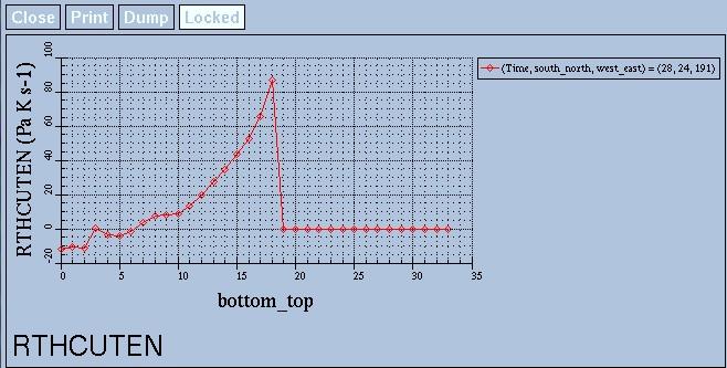
54 RTHCUTEN final time step


55 RQVCUTEN final time step
56 Revision of Convection and Vertical Diffusion Schemes Han and Pan 2011 in the NCEP Global Forecast System
57 Motivation Stratocumulus clouds Systematic underestimation, especially over nearshore regions in the eastern Pacific and Atlantic Oceans Attributed to the old SC scheme which uses a turbulent diffusion approach Gridpoint storms Excessively heavy precipitation at the grid scales during convective season Attributed to the DC scheme which cannot fully eliminate instability and consequently cause explicit convective ascent to occur on the grid scale


58 Modification Shallow convection: Mass flux parameterization Based on the previous SAS deep convection scheme: cloud-base mass flux, entrainment, and also detrainment specifications have been changed Deep convection: An entrainment rate approach with the rate being dependent on environmental moisture is used Make cumulus convection deeper and stronger
59 Modification (Cont d) Cumulus momentum transport due to convection-induced pressure gradient force are included in SC and DC Nonlocal PBL: A stratocumulus cloud-top-driven vertical diffusion scheme has been incorporated into the MRF PBL model Triggering mechanism: A parcel lifted from CSL without entrainment must reach its LFC within hPa of ascent Effects of environmental humidity in the subcloud layer, may be a deficiency as vertical model resolution change Empirical coefficients of cloud cover calculation


60 Accumulated precipitation from BMJ (top) and New-SAS (bottom)


61 Isosurfaces: 100 Pa m s -2 Warming Moist Cooling Dry
62 Assessing the performance of the Modified Tiedtke CP Scheme Hans P Taylor
63 Modified Tiedtke CP Scheme Characteristics Detrainment of condensates CAPE-based closure Mass-Flux Scheme Momentum Transport Shallow Convection Trigger Checks for unstable parcel in the lowest 350-hPa layer Cloud-top height determined from vertical velocity of parcel Cloud thickness must exceed 200 hpa Modifications Replaces moisture convergence with CAPE closure Prevent deep convection in dry regions, by establishing a threshold RH value (vertically averaged >= 0.8) Decreases fraction of cloud ensemble of shallow convection that penetrates into inversion layer Increases Entrainment-Detrainment rate for shallow convection (3) And (6) from Gregory et al., 2000

64 Performance comparison of CP Schemes

65 Sensitivity to choice of PBL Scheme
 at 84th hour of forecast using the Betts-Miller-Janjic convective parameterization")
 and Total Precipitation")
66 Figure 1: Spatial distribution of Convective Precipitation (Left) and Total Precipitation (Right) at 84th hour of forecast using the Betts-Miller-Janjic convective parameterization scheme. Figure 2: Spatial distribution of Convective Precipitation (Left) and Total Precipitation (Right) at 84th hour of forecast using the modified Tiedtke convective parameterization scheme

 using the BMJ CP scheme (right)")
, with distance along the")
67 Comparing Tendencies Cross-sections tendencies of potential temperature (bottom) and moisture mixing ratio (top) using the BMJ CP scheme (right) and modified Tiedtke CP scheme (left), with distance along the horizontal axis.
MEA 716 Exercise, BMJ CP Scheme With acknowledgements to B. Rozumalski, M. Baldwin, and J. Kain Optional Review Assignment, distributed Th 2/18/2016
 MEA 716 Exercise, BMJ CP Scheme With acknowledgements to B. Rozumalski, M. Baldwin, and J. Kain Optional Review Assignment, distributed Th 2/18/2016 We have reviewed the reasons why NWP models need to
Role of atmospheric aerosol concentration on deep convective precipitation: Cloud-resolving model simulations
 Role of atmospheric aerosol concentration on deep convective precipitation: Cloud-resolving model simulations Wei-Kuo Tao,1 Xiaowen Li,1,2 Alexander Khain,3 Toshihisa Matsui,1,2 Stephen Lang,4 and Joanne
A Study of Convective Initiation Failure on 22 Oct 2004
 A Study of Convective Initiation Failure on 22 Oct 2004 Jennifer M. Laflin Philip N. Schumacher NWS Sioux Falls, SD August 6 th, 2011 Introduction Forecasting challenge: strong forcing for ascent and large
Introduction. Effect of aerosols on precipitation: - challenging problem - no agreement between the results (quantitative and qualitative)
") Introduction Atmospheric aerosols affect the cloud mycrophysical structure & formation (observations, numerical studies) An increase of the aerosol particles: - increases CCN concentrations - decreases
Introduction Atmospheric aerosols affect the cloud mycrophysical structure & formation (observations, numerical studies) An increase of the aerosol particles: - increases CCN concentrations - decreases
Tue 3/1/2016. Arakawa-Schubert, Grell, Tiedtke, Zhang-McFarlane Explicit convection Review for MT exam
 Tue 3/1/2016 Convective parameterization: Arakawa-Schubert, Grell, Tiedtke, Zhang-McFarlane Explicit convection Review for MT exam Reminders/announcements: - Midterm Thu 3/3 (2014 exam posted on www page)
Real case simulations using spectral bin cloud microphysics: Remarks on precedence research and future activity
 Real case simulations using spectral bin cloud microphysics: Remarks on precedence research and future activity Takamichi Iguchi 1,2 (takamichi.iguchi@nasa.gov) 1 Earth System Science Interdisciplinary
Kelly Mahoney NOAA ESRL Physical Sciences Division
 The role of gray zone convective model physics in highresolution simulations of the 2013 Colorado Front Range Flood WRF model simulated precipitation over terrain in CO Front Range Kelly Mahoney NOAA ESRL
Chapter 7 Precipitation Processes
 Chapter 7 Precipitation Processes Chapter overview: Supersaturation and water availability Nucleation of liquid droplets and ice crystals Liquid droplet and ice growth by diffusion Collision and collection
Collision and Coalescence 3/3/2010. ATS 351 Lab 7 Precipitation. Droplet Growth by Collision and Coalescence. March 7, 2006
 ATS 351 Lab 7 Precipitation March 7, 2006 Droplet Growth by Collision and Coalescence Growth by condensation alone takes too long ( 15 C -) Occurs in clouds with tops warmer than 5 F Greater the speed
The Fifth-Generation NCAR / Penn State Mesoscale Model (MM5) Mark Decker Feiqin Xie ATMO 595E November 23, 2004 Department of Atmospheric Science
 Mark Decker Feiqin Xie ATMO 595E November 23, 2004 Department of Atmospheric Science") The Fifth-Generation NCAR / Penn State Mesoscale Model (MM5) Mark Decker Feiqin Xie ATMO 595E November 23, 2004 Department of Atmospheric Science Outline Basic Dynamical Equations Numerical Methods Initialization
The Fifth-Generation NCAR / Penn State Mesoscale Model (MM5) Mark Decker Feiqin Xie ATMO 595E November 23, 2004 Department of Atmospheric Science Outline Basic Dynamical Equations Numerical Methods Initialization
Microphysics Schemes in EMC s Operational Hurricane Models
 Microphysics Schemes in EMC s Operational Hurricane Models Brad Ferrier, Weiguo Wang, Eric Aligo 1,2 1 Environment Modeling Center (EMC)/NCEP/NWS 2 I.M. Systems Group, Inc. HFIP Physics Workshop 9 11 August
Sungsu Park, Chris Bretherton, and Phil Rasch
 Improvements in CAM5 : Moist Turbulence, Shallow Convection, and Cloud Macrophysics AMWG Meeting Feb. 10. 2010 Sungsu Park, Chris Bretherton, and Phil Rasch CGD.NCAR University of Washington, Seattle,
608 SENSITIVITY OF TYPHOON PARMA TO VARIOUS WRF MODEL CONFIGURATIONS
 608 SENSITIVITY OF TYPHOON PARMA TO VARIOUS WRF MODEL CONFIGURATIONS Phillip L. Spencer * and Brent L. Shaw Weather Decision Technologies, Norman, OK, USA Bonifacio G. Pajuelas Philippine Atmospheric,
TOPICS: What are Thunderstorms? Ingredients Stages Types Lightning Downburst and Microburst
 THUNDERSTORMS TOPICS: What are Thunderstorms? Ingredients Stages Types Lightning Downburst and Microburst What are Thunderstorms? A storm produced by a cumulonimbus cloud that contains lightning and thunder
A hierarchy of one- and two-moment microphysical parameterizations in the COSMO model
 Deutscher Wetterdienst GB Forschung und Entwicklung A hierarchy of one- and two-moment microphysical parameterizations in the COSMO model Axel Seifert German Weather Service Offenbach, Germany Ulrich Blahak
The New Thompson Microphysical Scheme in WRF
 The New Thompson Microphysical Scheme in WRF by W.D. Hall, Roy M. Rasmussen, and Gregory Thompson RAL, National Center for Atmospheric Research Boulder, CO 80307 Work funded by the FAA AWRP program Introduction
Key Laboratory of Mesoscale Severe Weather, Ministry of Education, School of Atmospheric Sciences, Nanjing University
 Modeling Rapid Intensification of Typhoon Saomai (2006) with the Weather Research and Forecasting Model and Sensitivity to Cloud Microphysical Parameterizations Jie Ming and Yuan Wang Key Laboratory of
Clouds and turbulent moist convection
 Clouds and turbulent moist convection Lecture 2: Cloud formation and Physics Caroline Muller Les Houches summer school Lectures Outline : Cloud fundamentals - global distribution, types, visualization
Tue 2/16/2016. Wrap-up on some WRF PBL options Paper presentations (Hans, Pat, Dylan, Masih, Xia, James) Begin convective parameterization (if time)
 Begin convective parameterization (if time)") Tue 2/16/2016 Finish turbulence and PBL closure: Wrap-up on some WRF PBL options Paper presentations (Hans, Pat, Dylan, Masih, Xia, James) Begin convective parameterization (if time) Reminders/announcements:
Tue 2/16/2016 Finish turbulence and PBL closure: Wrap-up on some WRF PBL options Paper presentations (Hans, Pat, Dylan, Masih, Xia, James) Begin convective parameterization (if time) Reminders/announcements:
Snow Microphysics and the Top-Down Approach to Forecasting Winter Weather Precipitation Type
 Roger Vachalek Journey Forecaster National Weather Service Des Moines, Iowa www.snowcrystals.com Why is Snow Microphysics Important? Numerical Prediction Models better forecast areas of large scale forcing
14B.1 Evaluating cloud microphysics schemes in nested NMMB forecasts
 14B.1 Evaluating cloud microphysics schemes in nested NMMB forecasts Brad Ferrier1,2 Weiguo Wang1,2 Edward Colón1,2 NOAA/NWS/NCEP Environmental Modeling Center (EMC) 2 IM Systems Group, Inc. (IMSG) 1 1
2012 AHW Stream 1.5 Retrospective Results
 2012 AHW Stream 1.5 Retrospective Results Ryan D. Torn, Univ. Albany, SUNY Chris Davis, Wei Wang, Jimy Dudhia, Tom Galarneau, Chris Snyder, James Done, NCAR/NESL/MMM Overview Since participation in HFIP
Precipitation AOSC 200 Tim Canty. Cloud Development: Orographic Lifting
 Precipitation AOSC 200 Tim Canty Class Web Site: http://www.atmos.umd.edu/~tcanty/aosc200 Topics for today: Precipitation formation Rain Ice Lecture 14 Oct 11 2018 1 Cloud Development: Orographic Lifting
Microphysics. Improving QPF and much more. Greg Thompson. Research Applications Laboratory Nat l Center for Atmospheric Research
 Microphysics Improving QPF and much more Greg Thompson Research Applications Laboratory Nat l Center for Atmospheric Research Outline Background Tests Results Applications Future Goals: NCAR-RAL microphysics
Di Wu, Xiquan Dong, Baike Xi, Zhe Feng, Aaron Kennedy, and Gretchen Mullendore. University of North Dakota
 Di Wu, Xiquan Dong, Baike Xi, Zhe Feng, Aaron Kennedy, and Gretchen Mullendore University of North Dakota Objectives 3 case studies to evaluate WRF and NAM performance in Oklahoma (OK) during summer 2007,
Inner core dynamics: Eyewall Replacement and hot towers
 Inner core dynamics: Eyewall Replacement and hot towers FIU Undergraduate Hurricane Internship Lecture 4 8/13/2012 Why inner core dynamics is important? Current TC intensity and structure forecasts contain
Short Term forecasts along the GCSS Pacific Cross-section: Evaluating new Parameterizations in the Community Atmospheric Model
 Short Term forecasts along the GCSS Pacific Cross-section: Evaluating new Parameterizations in the Community Atmospheric Model Cécile Hannay, Dave Williamson, Jerry Olson, Rich Neale, Andrew Gettelman,
1. Base your answer to the following question on the weather map below, which shows a weather system that is affecting part of the United States.
 1. Base your answer to the following question on the weather map below, which shows a weather system that is affecting part of the United States. Which sequence of events forms the clouds associated with
ANALYSIS OF THE MPAS CONVECTIVE-PERMITTING PHYSICS SUITE IN THE TROPICS WITH DIFFERENT PARAMETERIZATIONS OF CONVECTION REMARKS AND MOTIVATIONS
 ANALYSIS OF THE MPAS CONVECTIVE-PERMITTING PHYSICS SUITE IN THE TROPICS WITH DIFFERENT PARAMETERIZATIONS OF CONVECTION Laura D. Fowler 1, Mary C. Barth 1, K. Alapaty 2, M. Branson 3, and D. Dazlich 3 1
The Earth System - Atmosphere III Convection
 The Earth System - Atmosphere III Convection Thunderstorms 1. A thunderstorm is a storm that produces lightning (and therefore thunder) 2. Thunderstorms frequently produce gusty winds, heavy rain, and
Impact of different cumulus parameterizations on the numerical simulation of rain over southern China
 Impact of different cumulus parameterizations on the numerical simulation of rain over southern China P.W. Chan * Hong Kong Observatory, Hong Kong, China 1. INTRODUCTION Convective rain occurs over southern
Mesoscale modeling of lake effect snow over Lake Engineering Erie sensitivity to convection, microphysics and. water temperature
 Open Sciences Author(s) 2010. This work is distributed under the Creative Commons Attribution 3.0 License. Advances in Science & Research Open Access Proceedings Drinking Water Mesoscale modeling of lake
Improved rainfall and cloud-radiation interaction with Betts-Miller-Janjic cumulus scheme in the tropics
 Improved rainfall and cloud-radiation interaction with Betts-Miller-Janjic cumulus scheme in the tropics Tieh-Yong KOH 1 and Ricardo M. FONSECA 2 1 Singapore University of Social Sciences, Singapore 2
9 Condensation. Learning Goals. After studying this chapter, students should be able to:
 9 Condensation Learning Goals After studying this chapter, students should be able to: 1. explain the microphysical processes that operate in clouds to influence the formation and growth of cloud droplets
Forecasting Local Weather
 Forecasting Local Weather Sea/Land Breeze Temperature Dew Fog Frost Snow Thunderstorms Tropical Cyclones Temperatures: Radiation Balance Typical Diurnal Variation of Temperature Min soon after dawn Temp
Justin Arnott and Michael Evans NOAA National Weather Service, Binghamton, NY. Richard Grumm NOAA National Weather Service, State College, PA
 3A.5 REGIONAL SCALE ENSEMBLE FORECAST OF THE LAKE EFFECT SNOW EVENT OF 7 FEBRUARY 2007 Justin Arnott and Michael Evans NOAA National Weather Service, Binghamton, NY Richard Grumm NOAA National Weather
Charles A. Doswell III, Harold E. Brooks, and Robert A. Maddox
 Charles A. Doswell III, Harold E. Brooks, and Robert A. Maddox Flash floods account for the greatest number of fatalities among convective storm-related events but it still remains difficult to forecast
Weather Research and Forecasting Model. Melissa Goering Glen Sampson ATMO 595E November 18, 2004
 Weather Research and Forecasting Model Melissa Goering Glen Sampson ATMO 595E November 18, 2004 Outline What does WRF model do? WRF Standard Initialization WRF Dynamics Conservation Equations Grid staggering
SIMULATION OF ATMOSPHERIC STATES FOR THE CASE OF YEONG-GWANG STORM SURGE ON 31 MARCH 2007 : MODEL COMPARISON BETWEEN MM5, WRF AND COAMPS
 SIMULATION OF ATMOSPHERIC STATES FOR THE CASE OF YEONG-GWANG STORM SURGE ON 31 MARCH 2007 : MODEL COMPARISON BETWEEN MM5, WRF AND COAMPS JEONG-WOOK LEE 1 ; KYUNG-JA HA 1* ; KI-YOUNG HEO 1 ; KWANG-SOON
Short Term forecasts along the GCSS Pacific Cross-section: Evaluating new Parameterizations in the Community Atmospheric Model
 Short Term forecasts along the GCSS Pacific Cross-section: Evaluating new Parameterizations in the Community Atmospheric Model Cécile Hannay, Dave Williamson, Jerry Olson, Rich Neale, Andrew Gettelman,
Moist convec+on in models (and observa+ons)
") Moist convec+on in models (and observa+ons) Cathy Hohenegger Moist convec+on in models (and observa+ons) Cathy Hohenegger How do we parameterize convec+on? Precipita)on response to soil moisture Increase
Moist convec+on in models (and observa+ons) Cathy Hohenegger Moist convec+on in models (and observa+ons) Cathy Hohenegger How do we parameterize convec+on? Precipita)on response to soil moisture Increase
Track sensitivity to microphysics and radiation
 Track sensitivity to microphysics and radiation Robert Fovell and Yizhe Peggy Bu, UCLA AOS Brad Ferrier, NCEP/EMC Kristen Corbosiero, U. Albany 11 April 2012 rfovell@ucla.edu 1 Background WRF-ARW, including
Climate Modeling Issues at GFDL on the Eve of AR5
 Climate Modeling Issues at GFDL on the Eve of AR5 Leo Donner, Chris Golaz, Yi Ming, Andrew Wittenberg, Bill Stern, Ming Zhao, Paul Ginoux, Jeff Ploshay, S.J. Lin, Charles Seman CPPA PI Meeting, 29 September
Air stability. About. Precipitation. air in unstable equilibrium will move--up/down Fig. 5-1, p.112. Adiabatic = w/ no exchange of heat from outside!
 Air stability About clouds Precipitation A mass of moist, stable air gliding up and over these mountains condenses into lenticular clouds. Fig. 5-CO, p.110 air in unstable equilibrium will move--up/down
Chapter 7: Precipitation Processes. ESS5 Prof. Jin-Yi Yu
 Chapter 7: Precipitation Processes From: Introduction to Tropical Meteorology, 1st Edition, Version 1.1.2, Produced by the COMET Program Copyright 2007-2008, 2008, University Corporation for Atmospheric
Thunderstorm-Scale EnKF Analyses Verified with Dual-Polarization, Dual-Doppler Radar Data
 Thunderstorm-Scale EnKF Analyses Verified with Dual-Polarization, Dual-Doppler Radar Data David Dowell and Wiebke Deierling National Center for Atmospheric Research, Boulder, CO Ensemble Data Assimilation
Impact of GPS RO Data on the Prediction of Tropical Cyclones
 Impact of GPS RO Data on the Prediction of Tropical Cyclones Ying-Hwa Kuo, Hui Liu, UCAR Ching-Yuang Huang, Shu-Ya Chen, NCU Ling-Feng Hsiao, Ming-En Shieh, Yu-Chun Chen, TTFRI Outline Tropical cyclone
Storm and Storm Systems Related Vocabulary and Definitions. Magnitudes are measured differently for different hazard types:
 Storm and Storm Systems Related Vocabulary and Definitions Magnitude: this is an indication of the scale of an event, often synonymous with intensity or size. In natural systems, magnitude is also related
Thanksgiving Snow and Arctic Front 25 November 2005 By Richard H. Grumm National Weather Service State College, PA 16801
 Thanksgiving Snow and Arctic Front 25 November 2005 By Richard H. Grumm National Weather Service State College, PA 16801 1. INTRODUCTION An approaching arctic front brought light snow to most of western
HWRF sensitivity to cumulus schemes
 HWRF sensitivity to cumulus schemes Mrinal K Biswas and Ligia R Bernardet HFIP Telecon, 01 February 2012 Motivation HFIP Regional Model Team Physics Workshop (Aug 11): Foci: Scientific issues on PBL and
Weather Systems III: Thunderstorms and Twisters
 Weather Systems III: Thunderstorms and Twisters Review 1. Definition of airmasses? Bergeron classification of air masses 2. Surface weather analysis: Station model, wind speed code, present weather 3.
Mid-Latitude Cyclones and Fronts. Lecture 12 AOS 101
 Mid-Latitude Cyclones and Fronts Lecture 12 AOS 101 Homework 4 COLDEST TEMPS GEOSTROPHIC BALANCE Homework 4 FASTEST WINDS L Consider an air parcel rising through the atmosphere The parcel expands as it
Precipitation Structure and Processes of Typhoon Nari (2001): A Modeling Propsective
: A Modeling Propsective") Precipitation Structure and Processes of Typhoon Nari (2001): A Modeling Propsective Ming-Jen Yang Institute of Hydrological Sciences, National Central University 1. Introduction Typhoon Nari (2001) struck
Precipitation Structure and Processes of Typhoon Nari (2001): A Modeling Propsective Ming-Jen Yang Institute of Hydrological Sciences, National Central University 1. Introduction Typhoon Nari (2001) struck
How strong does wind have to be to topple a garbage can?
 How strong does wind have to be to topple a garbage can? Imagine winds powerful enough to pick up a truck and toss it the length of a football field. Winds of this extreme sometimes happen in a tornado.
Summary of November Central U.S. Winter Storm By Christopher Hedge
 Summary of November 12-13 2010 Central U.S. Winter Storm By Christopher Hedge Event Overview The first significant snowfall of the 2010-2011 season affected portions of the plains and upper Mississippi
INVESTIGATION FOR A POSSIBLE INFLUENCE OF IOANNINA AND METSOVO LAKES (EPIRUS, NW GREECE), ON PRECIPITATION, DURING THE WARM PERIOD OF THE YEAR
, ON PRECIPITATION, DURING THE WARM PERIOD OF THE YEAR") Proceedings of the 13 th International Conference of Environmental Science and Technology Athens, Greece, 5-7 September 2013 INVESTIGATION FOR A POSSIBLE INFLUENCE OF IOANNINA AND METSOVO LAKES (EPIRUS,
Proceedings of the 13 th International Conference of Environmental Science and Technology Athens, Greece, 5-7 September 2013 INVESTIGATION FOR A POSSIBLE INFLUENCE OF IOANNINA AND METSOVO LAKES (EPIRUS,
DEPARTMENT OF EARTH & CLIMATE SCIENCES NAME SAN FRANCISCO STATE UNIVERSITY Fall ERTH FINAL EXAMINATION KEY 200 pts
 DEPARTMENT OF EARTH & CLIMATE SCIENCES NAME SAN FRANCISCO STATE UNIVERSITY Fall 2016 Part 1. Weather Map Interpretation ERTH 365.02 FINAL EXAMINATION KEY 200 pts Questions 1 through 9 refer to Figure 1,
Precipitations. Terminal Velocity. Chapter 7: Precipitation Processes. Growth of Cloud Droplet Forms of Precipitations Cloud Seeding
 Chapter 7: Precipitation Processes Precipitations Water Vapor Saturated Need cloud nuclei Cloud Droplet formed around Cloud Nuclei Growth of Cloud Droplet Forms of Precipitations Cloud Seeding Precipitation
The Impacts of GPSRO Data Assimilation and Four Ices Microphysics Scheme on Simulation of heavy rainfall Events over Taiwan during June 2012
 The Impacts of GPSRO Data Assimilation and Four Ices Microphysics Scheme on Simulation of heavy rainfall Events over Taiwan during 10-12 June 2012 Pay-Liam LIN, Y.-J. Chen, B.-Y. Lu, C.-K. WANG, C.-S.
Crux of AGW s Flawed Science (Wrong water-vapor feedback and missing ocean influence)
") 1 Crux of AGW s Flawed Science (Wrong water-vapor feedback and missing ocean influence) William M. Gray Professor Emeritus Colorado State University There are many flaws in the global climate models. But
1 Crux of AGW s Flawed Science (Wrong water-vapor feedback and missing ocean influence) William M. Gray Professor Emeritus Colorado State University There are many flaws in the global climate models. But
Clouds on Mars Cloud Classification
 Lecture Ch. 8 Cloud Classification Descriptive approach to clouds Drop Growth and Precipitation Processes Microphysical characterization of clouds Complex (i.e. Real) Clouds Examples Curry and Webster,
Department of Meteorology, University of Utah, Salt Lake City, UT. Second revision. Submitted to Monthly Weather Review.
 Sensitivity of Numerical Simulation of Early Rapid Intensification of Hurricane Emily (2005) to Cloud Microphysical and Planetary Boundary Layer Parameterizations XUANLI LI and ZHAOXIA PU * Department
NATS 1750 Lecture. Wednesday 28 th November Pearson Education, Inc.
 NATS 1750 Lecture Wednesday 28 th November 2012 Processes that lift air Orographic lifting Elevated terrains act as barriers Result can be a rainshadow desert Frontal wedging Cool air acts as a barrier
Moisture, Clouds, and Precipitation Earth Science, 13e Chapter 17
 Moisture, Clouds, and Precipitation Earth Science, 13e Chapter 17 Stanley C. Hatfield Southwestern Illinois College Changes of state of water, H 2 O Water is the only substance in atmosphere that exists
Effects of aerosols on the dynamics and microphysics of squall lines simulated by spectral bin and bulk parameterization schemes
 JOURNAL OF GEOPHYSICAL RESEARCH, VOL. 114,, doi:10.1029/2009jd011902, 2009 Effects of aerosols on the dynamics and microphysics of squall lines simulated by spectral bin and bulk parameterization schemes
Chapter 14 Thunderstorm Fundamentals
 Chapter overview: Thunderstorm appearance Thunderstorm cells and evolution Thunderstorm types and organization o Single cell thunderstorms o Multicell thunderstorms o Orographic thunderstorms o Severe
The Purdue Lin Microphysics Scheme in WRF. Russ Schumacher AT 730 Final Project 26 April 2006
 The Purdue Lin Microphysics Scheme in WRF Russ Schumacher AT 730 Final Project 26 April 2006 Overview Introduction to microphysics schemes Introduction to the Purdue Lin scheme Tunable coefficients, inputs
SEVERE AND UNUSUAL WEATHER
 SEVERE AND UNUSUAL WEATHER Basic Meteorological Terminology Adiabatic - Referring to a process without the addition or removal of heat. A temperature change may come about as a result of a change in the
CAPS Storm-Scale Ensemble Forecast for the NOAA Hazardous Weather Testbed (HWT) Spring Experiment
 Spring Experiment") CAPS Storm-Scale Ensemble Forecast for the NOAA Hazardous Weather Testbed (HWT) Spring Experiment Fanyou Kong, Ming Xue, Kevin W. Thomas, Yunheng Wang, Keith Brewster, Xuguang Wang (Center for Analysis
CAPS Storm-Scale Ensemble Forecast for the NOAA Hazardous Weather Testbed (HWT) Spring Experiment Fanyou Kong, Ming Xue, Kevin W. Thomas, Yunheng Wang, Keith Brewster, Xuguang Wang (Center for Analysis
Page 1. Name:
 Name: 1) As the difference between the dewpoint temperature and the air temperature decreases, the probability of precipitation increases remains the same decreases 2) Which statement best explains why
PALM - Cloud Physics. Contents. PALM group. last update: Monday 21 st September, 2015
 PALM - Cloud Physics PALM group Institute of Meteorology and Climatology, Leibniz Universität Hannover last update: Monday 21 st September, 2015 PALM group PALM Seminar 1 / 16 Contents Motivation Approach
Extratropical and Polar Cloud Systems
 Extratropical and Polar Cloud Systems Gunilla Svensson Department of Meteorology & Bolin Centre for Climate Research George Tselioudis Extratropical and Polar Cloud Systems Lecture 1 Extratropical cyclones
Name Date Hour Table. Chapter 12-AP Lesson One
 Name Date Hour Table 1. Chapter 12-AP Lesson One 2. 3. 4. 5. 6. 7. 8. 9. 10. 11. 12. 13. 14. 15. 16. 17. 18. 19. 20. 21. 22. Name Date Hour Table Directions: Answer each question to create your word bank.
A Description of Convective Weather Containing Ice Crystals Associated with Engine Powerloss and Damage
 A Description of Convective Weather Containing Ice Crystals Associated with Engine Powerloss and Damage The Boeing Company 1 Photo: courtesy of Ian McPherson The Boeing Company acknowledges the contributions
Rogers and Yau Chapter 10: Drop breakup, snow, precip rate, and bulk models
 Rogers and Yau Chapter 10: Drop breakup, snow, precip rate, and bulk models One explanation for the negative exponential (M-P) distribution of raindrops is drop breakup. Drop size is limited because increased
Variational data assimilation of lightning with WRFDA system using nonlinear observation operators
 Variational data assimilation of lightning with WRFDA system using nonlinear observation operators Virginia Tech, Blacksburg, Virginia Florida State University, Tallahassee, Florida rstefane@vt.edu, inavon@fsu.edu
latent heat/humidity
 1. Base your answer(s) to the following question(s) on the Earth Science Reference Tables, the graph below, and your knowledge of Earth science. The graph shows variations in air temperature and relative
A FROZEN DROP PRECIPITATION MECHANISM OVER AN OPEN OCEAN AND ITS EFFECT ON RAIN, CLOUD PATTERN, AND HEATING
 A FROZEN DROP PRECIPITATION MECHANISM OVER AN OPEN OCEAN AND ITS EFFECT ON RAIN, CLOUD PATTERN, AND HEATING 13.6 Tsutomu Takahashi* University of Hawaii, Honolulu, Hawaii Kazunori Shimura JFE Techno-Research
meso-sas, a modification of the SAS for meso-scale models Hua-Lu pan Qingfu Liu
 meso-sas, a modification of the SAS for meso-scale models Hua-Lu pan Qingfu Liu Problem with the conventional mass flux schemes Most of the mass-flux schemes are based on the original Arakawa-Schubert
WaVaCS summerschool Autumn 2009 Cargese, Corsica
 Introduction Part I WaVaCS summerschool Autumn 2009 Cargese, Corsica Holger Tost Max Planck Institute for Chemistry, Mainz, Germany Introduction Overview What is a parameterisation and why using it? Fundamentals
CHAPTER 8 NUMERICAL SIMULATIONS OF THE ITCZ OVER THE INDIAN OCEAN AND INDONESIA DURING A NORMAL YEAR AND DURING AN ENSO YEAR
 CHAPTER 8 NUMERICAL SIMULATIONS OF THE ITCZ OVER THE INDIAN OCEAN AND INDONESIA DURING A NORMAL YEAR AND DURING AN ENSO YEAR In this chapter, comparisons between the model-produced and analyzed streamlines,
The most abundant gas in the atmosphere by volume is. This gas comprises 78% of the Earth atmosphere by volume.
 The most abundant gas in the atmosphere by volume is. This gas comprises 78% of the Earth atmosphere by volume. A. Oxygen B. Water Vapor C. Carbon Dioxide D. Nitrogen An isobar is a line of constant. A.
Simulating roll clouds associated with low-level convergence in WRF
 Simulating roll clouds associated with low-level convergence in WRF Abhnil Prasad1,3, Steven Sherwood1,3 and Hélène Brogniez2 1 Climate Change Research Centre, University of New South Wales, Sydney, NSW,
25.1 Air Masses. Section 25.1 Objectives
 Section 25.1 Objectives Explain how an air mass forms. List the four main types of air masses. Describe how air masses affect the weather of North America. Air Masses 25.1 Air Masses Differences in air
Science Olympiad Meteorology Quiz #1 Page 1 of 7
 1) What is generally true about the stratosphere: a) Has turbulent updrafts and downdrafts. b) Has either a stable or increasing temperature profile with altitude. c) Where the auroras occur. d) Both a)
The Effect of Sea Spray on Tropical Cyclone Intensity
 The Effect of Sea Spray on Tropical Cyclone Intensity Jeffrey S. Gall, Young Kwon, and William Frank The Pennsylvania State University University Park, Pennsylvania 16802 1. Introduction Under high-wind
Foundations of Earth Science, 6e Lutgens, Tarbuck, & Tasa
 Foundations of Earth Science, 6e Lutgens, Tarbuck, & Tasa Weather Patterns and Severe Weather Foundations, 6e - Chapter 14 Stan Hatfield Southwestern Illinois College Air masses Characteristics Large body
A Revised Version of the Cloud Microphysical Parameterization of COSMO-LME
 A Revised Version of the Cloud Microphysical Parameterization of COSMO-LME Axel Seifert DWD, Offenbach -1- Motivation: Well known problems of COSMO-LME regards wintertime precipitation: Overestimation
Talking Points for VISIT Lake-effect Snow II session
 Talking Points for VISIT Lake-effect Snow II session 1. Title 2. Objectives 3. Mesoscale model limitations 4. Horizontal Resolution - The delta X rule refers to the width of the feature divided by the
MOISTURE IN THE ATMOSPHERE MEGA PACKET
 NAME: MEGA PACKET 1. A psychrometer is used to determine which weather variables? A) wind speed and wind direction B) percentage of cloud cover and cloud height C) air pressure and air temperature D) relative
In this chapter we explain the processes by which nonprecipitating cloud droplets and ice crystals grow large enough to fall as precipitation
 Goals for today: 19 Oct., 2011 Ch 7, Precipitation Processes In this chapter we explain the processes by which nonprecipitating cloud droplets and ice crystals grow large enough to fall as precipitation
Cloud parameterization and cloud prediction scheme in Eta numerical weather model
 Cloud parameterization and cloud prediction scheme in Eta numerical weather model Belgrade, 10th September, 2018 Ivan Ristić, CEO at Weather2 Ivana Kordić, meteorologist at Weather2 Introduction Models
An improvement of the SBU-YLIN microphysics scheme in squall line simulation
 1 An improvement of the SBU-YLIN microphysics scheme in squall line simulation Qifeng QIAN* 1, and Yanluan Lin 1 ABSTRACT The default SBU-YLIN scheme in Weather Research and Forecasting Model (WRF) is
A New Method for Representing Mixed-phase Particle Fall Speeds in Bulk Microphysics Parameterizations
 November Journal of the 2008 Meteorological Society of Japan, Vol. J. 86A, DUDHIA pp. 33 44, et al. 2008 33 A New Method for Representing Mixed-phase Particle Fall Speeds in Bulk Microphysics Parameterizations
1. describe the two methods by which cloud droplets can grow to produce precipitation (pp );
;") 10 Precipitation Learning Goals After studying this chapter, students should be able to: 1. describe the two methods by which cloud droplets can grow to produce precipitation (pp. 232 236); 2. distinguish
10 Precipitation Learning Goals After studying this chapter, students should be able to: 1. describe the two methods by which cloud droplets can grow to produce precipitation (pp. 232 236); 2. distinguish
A New Vertical Diffusion Package with an Explicit Treatment of Entrainment Processes
 2318 M O N T H L Y W E A T H E R R E V I E W VOLUME 134 A New Vertical Diffusion Package with an Explicit Treatment of Entrainment Processes SONG-YOU HONG AND YIGN NOH Department of Atmospheric Sciences,
Mr. P s Science Test!
 WEATHER- 2017 Mr. P s Science Test! # Name Date 1. Draw and label a weather station model. (10 pts) 2. The is the layer of the atmosphere with our weather. 3. Meteorologists classify clouds in about different
Thundersnow. flightops. Difficult to forecast and rare, but a real threat to landing or low-altitude aircraft. By Ed Brotak
 Thundersnow Difficult to forecast and rare, but a real threat to landing or low-altitude aircraft. By Ed Brotak 18 flight safety foundation AeroSafetyWorld October 2010 flightops Mike Tigas/Flickr It was
Sensitivity of tropical cyclone Jal simulations to physics parameterizations
 Sensitivity of tropical cyclone Jal simulations to physics parameterizations R Chandrasekar and C Balaji Department of Mechanical Engineering, Indian Institute of Technology, Madras, Chennai 6 36, India.
Chapter The transition from water vapor to liquid water is called. a. condensation b. evaporation c. sublimation d.
 Chapter-6 Multiple Choice Questions 1. The transition from water vapor to liquid water is called. a. condensation b. evaporation c. sublimation d. deposition 2. The movement of water among the great global