A full moon night reveals some of the terrestrial and celestial scenery awaiting visitors to Cedar Breaks National Monument (Photo: Zach Schierl/NPS)
|
|
|
- Avice Bryant
- 6 years ago
- Views:
Transcription

1 A full moon night reveals some of the terrestrial and celestial scenery awaiting visitors to Cedar Breaks National Monument (Photo: Zach Schierl/NPS) 1
2 Nomination Letter... 3 Letter of Support from Park Superintendent Park Description... 6 Park Resources... 8 Visitor Services Description of Night Sky Resources Current Conditions Visual Observations Sky Quality Meter Monitoring NPS Night Sky Team Data Future Conditions Dark Skies Education & Outreach Astronomy and Dark Sky Interpretive Programs Community Outreach & Partnerships Online & Social Media Interpretation of Monument Lighting Staffing & Future Plans Management Documents NPS Management Policies Supporting Dark Skies Cedar Breaks Management Documents Supporting Dark Skies Cedar Breaks National Monument Lighting Management Plan (LMP) Purpose Lighting Zones Lighting Standards Conclusion Park Lighting Inventory Letters of Support Acknowledgements Contributors Special Thanks To References
3 3
4 4
5 5
, and is located in southwestern Utah approximately 13 miles east of Cedar City and 220 miles SSW of Salt Lake City.")

6 Cedar Breaks National Monument (CEBR) was established on August 22, 1933 by President Franklin D. Roosevelt. The monument is administered by the United States National Park Service (NPS), and is located in southwestern Utah approximately 13 miles east of Cedar City and 220 miles SSW of Salt Lake City. The monument was created in order to protect the spectacular cliffs, canyons and scenery of the Cedar Breaks Amphitheater (Fig 1) and the high alpine ecosystem on the Markagunt Plateau. Today, the monument protects 6,155 acres of land ranging in elevation from 8,100 to 10,662, making Cedar Breaks NM one of the most easily accessible high altitude units in the NPS. All land below the amphitheater rim (the majority of the monument) is recommended wilderness. There are no private inholdings within the monument boundaries. Figure 1-Cedar Breaks Amphitheater at sunset (Photo: Zach Schierl/NPS) Cedar Breaks NM is almost completely surrounded by the Dixie National Forest, managed by the United States Department of Agriculture (USDA), including the congressionally designated Ashdown Gorge Wilderness to the west. Road access to the monument is via Utah Highway 143 which crosses the northeast corner of the monument, and Utah Highway 148 which runs along the eastern edge of the monument, connecting Hwy 143 with Utah Highway 14 to the south (Fig 2). Much of the monument consists of the extremely steep and rugged terrain of the Cedar Breaks Amphitheater which contains no maintained trails or routes and can only be accessed on foot. 6

7 The area to be designated as an International Dark Sky Park includes the entirety of Cedar Breaks National Monument, as shown on the following map: Figure 2-Map of Cedar Breaks National Monument 7
8 Geology: Cedar Breaks is named for the rugged escarpment or breaks cut into the Claron Formation, a layer of sedimentary rock deposited in an ancient lake basin that covered much of southwestern Utah during the Eocene epoch. Over the past 10 million years, movement along the Hurricane Fault has elevated the land to the east of Cedar City to an elevation of up to 11,000 feet above sea level, forming the modern-day Markagunt Plateau. This uplift of the plateau has exposed the soft rocks of the Claron Formation to weathering and erosion, sculpting a 2,500 foot high, four mile wide, westward-facing amphitheater. The amphitheater is a magnificent scene containing towering hoodoos, terraced cliffs, arches, and windows, all cut into the vibrantly colored strata of the Claron Formation. Cedar Breaks combination of an exceptional rate of erosion, high elevation, and brilliantly colored rock formations make it a geologic treasure. Ecology: Cedar Breaks National Monument protects a variety of distinctive flora and fauna, including intensely beautiful summer wildflower displays, ancient bristlecone pines more than 1,600 years old, and a variety of subalpine wildlife. These species have adapted to the severity of climate and weather on the high elevations of the Markagunt Plateau, contributing to the resilience and integrity of the greater subalpine ecosystem. Many of the monument s resident wildlife species, including, but not limited to bats, red fox, jackrabbits, mountain lions, and porcupines, are nocturnal, and require a naturally dark photic environment at night in order to thrive. History: Cedar Breaks lies within the traditional homeland of the Southern Paiutes. According to their oral traditions, they have always been here. Archaeologists have documented sites of ancestral American Indians or their habitations within and surrounding Cedar Breaks dating back more than 10,000 years. Cedar Breaks protects evidence of some of the highest elevation prehistoric sites within the national park system, representing the astonishing ability of humans to adapt to extreme and at times harsh environments. Weather and Climate: The rim of Cedar Breaks amphitheater sits at over 10,000 feet in elevation. On average, Cedar Breaks receives 33.6 inches of precipitation and roughly 15 feet of snow annually. Summertime highs average between 60 and 80 F. Nighttime lows often dip into the 30s and 40s F. Temperatures drop below freezing about 250 nights out of the year. Thunderstorms frequently develop on summer afternoons and the high altitude means that weather can change rapidly during any time of year. Visitor services at the monument include a visitor center and bookstore housed in a small cabin (built by the Civilian Conservation Corp in 1937), a 25-site campground, picnic area, hiking trails, and several scenic viewpoints along Highways 143 & 148. There are no food or lodging facilities within the monument. The closest towns are Brian Head (year-round pop: ~100, 10 minutes) and Cedar City (pop ~30,000, 35 minutes). 8
9 Over the past five years, Cedar Breaks National Monument has received an average of approximately 630,000 visitors per year, mostly between the months of June and October. While the monument is open year round, heavy winter snows limit access in the winter. The section of UT Hwy 143 that passes through the northeast corner of the monument is maintained during the winter. However, access to the visitor center, campground, and most other visitor facilities is via Utah Highway 148, which is closed in the winter. Automobile access to the majority of the monument is thus limited after the first significant snowfall of the year, and can thereafter be accessed only by snowmobile, ski, or snowshoe. Cedar Breaks experiences very high visitation for a national monument of its size, in part due to its close proximity to I-15, and the fact that Cedar Breaks is located on the Grand Circle of southwestern national parks and monuments. Cedar Breaks was home to a rustic lodge, originally built and operated by the Utah Parks Company, until the mid-1970s, and is often visited as part of an itinerary including Zion, Bryce Canyon, Grand Canyon, and other regional attractions. Cedar Breaks National Monument is open 24 hours/day and 365 days/year. Apart from the challenges of accessing the monument during the winter months, there are no restrictions or limitations on visitors accessing the monument at night to enjoy the dark night skies on their own. As of 2016, the monument charges an entrance fee when visitor services (visitor center, restrooms, etc) are open (Memorial Day to Columbus Day) which is currently $5 per person age 16 or older. 9

10 The high elevation, clean air, remote location, and minimal development in and around Cedar Breaks National Monument combine to produce night skies of superb quality. Cedar Breaks is located within a day s drive of Los Angeles, Las Vegas, St. George, and Salt Lake City, yet is far enough from these population centers that the night sky remains extremely dark. This makes Cedar Breaks uniquely positioned to educate a diverse audience about the importance of preserving the night sky and the benefits of natural darkness. Sources of light pollution within the monument itself are limited to non-existent. There are fewer than a dozen structures in use within the monument, all of which are either not regularly lit at night or utilize night-sky friendly lighting fixtures (see lighting inventory, section 6). The most significant source of artificial light at night visible from Cedar Breaks is the skyglow originating from the nearby municipalities of Cedar City (13 miles W), St. George (54 miles SW), and Brian Head (2 north of monument boundary) (Fig 3). 30 sec, f/2.8, ISO 1600 St George 30 sec, f/2.8, ISO 2500 St George Cedar City Brian Head/ Parowan 30 sec, f/2.8, ISO 2500, brightness increased Figure 3-Three 360 panoramas of night sky conditions taken from Point Supreme Overlook within Cedar Breaks National Monument on 11/2/16. Images were taken with identical camera settings, except for those noted in the captions. The top image (ISO 1600) most closely approximates the appearance of the light domes as seen with the naked eye (the Brian Head/Parowan light dome is visible, but barely to the dark adapted eye) (Photos: Zach Schierl/NPS) 10


11 Despite the presence of skyglow from the aforementioned towns and cities, the night sky at Cedar Breaks remains very dark. Figure 4 (from the New World Atlas of Artificial Night Sky Brightness, Falchi et al. 2016) shows that the ratio of artificial night sky brightness to natural night sky brightness at Cedar Breaks is low compared to most of southwestern Utah. The bright and dark blue color bands in which Cedar Breaks lies indicates that the amount of artificial light in the night sky is only 4%-16% higher than natural conditions. Cedar Breaks NM Zion NP Bryce Canyon NP Figure 4-Portion of the "New World Atlas of Artificial Night Sky Brightness" showing modeled sky brightness conditions for southwestern Utah. Purple areas are units of the US National Park Service (Falchi et al. 2016) 11
 and are comparable in brightness to the brightest portions of the Milky Way.")

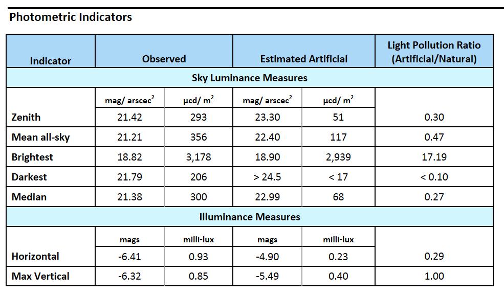
12 From Cedar Breaks NM, the moonless night sky is sufficiently dark that the Milky Way is easily visible from horizon to horizon and shows great detail and structure (Fig 5). Light domes are limited to the horizon (Fig 3) and are comparable in brightness to the brightest portions of the Milky Way. Deep-sky objects such as M31, M15, M22, and M8 are easily visible to the naked eye on a moonless night. The zodiacal light can also be seen under favorable conditions. The high elevation of Cedar Breaks also contributes to the superb night sky viewing. Using the Bortle Dark Sky Scale, the skies of Cedar Breaks fit the description of a Class 2 or Class 3 sky. Figure 5-The summer Milky Way seen from Point Supreme at Cedar Breaks National Monument. Blue light on the horizon is not skyglow, but rather light from a rising waning gibbous moon. (Photo: Zach Schierl) In order to quantify current night sky conditions at Cedar Breaks, the monument purchased an IDA approved Unihedron Sky Quality Meter (SQM, wide-angle version) in early 2016 and began a regular night sky monitoring program shortly thereafter. Trained Cedar Breaks interpretive staff record SQM measurements on each clear, moonless Saturday evening during the summer months following public astronomy programs. Periodic winter measurements will also be recorded as weather and sky conditions permit. Since beginning the monitoring program, SQM measurements from the Visitor Center have typically been in the mag/arcsec 2 range, indicating a nearly pristine night sky at the zenith (Table 1). Degradation of the night sky at Cedar Breaks is predominantly due to light domes within about 20 degrees of the horizon to the west and north, which are not captured by the SQM. 12
13 Table 1: Cedar Breaks National Monument Sky Quality Meter (SQM) Observations Local Date & Time : : : : :22 Location Point Supreme Overlook Point Supreme Overlook Point Supreme Overlook Point Supreme Overlook Point Supreme Overlook Temp ( C) Average SQM reading (mags/arcsec 2 ) Comments/sky conditions Very hazy, but clear Pretty clear, some haze Clear, with intermittent lightning to north Clear Bright airglow present in photographs (see Fig 3) A sky quality survey was conducted on September 26, 2016, in which SQM measurements were taken at a dozen locations throughout the monument and surrounding areas on the same evening (Table 2). The location of these points is shown in Figure 6. The survey was conducted on a clear, moonless evening following the end of astronomical twilight to ensure that the sky was dark. The method suggested by the IDA ( was used. At each location, five measurements were taken with the SQM and the results averaged to produce the sky luminance values given in Table 2. These data show that night sky luminance across Cedar Breaks National Monument is quite consistent. Sky luminance increases slightly at the northern end of the monument, likely due to increased skyglow from Brian Head Town just outside the monument s northern boundary. Note that all the measurements presented here are from the eastern portion of the monument, which is the only part accessible by road. The western portion of the monument is about two miles closer to Cedar City, but is not accessible by road or trail so staff has not yet been table to take SQM measurements from this part of the monument. One measurement was taken at Cedar Canyon Campground (U.S. Forest Service) which is located just southwest of the monument. Even though this location is closer to Cedar City, the sky quality was comparable to the measurements 13
14 taken within Cedar Breaks, indicating that the western portions of the monument are not likely to be significantly brighter. Local Time 21:00 21:11 21:16 21:20 Table 2: Cedar Breaks National Monument Sky Quality Meter (SQM) Survey ( ) Location Cedar Canyon CG (COMPARISON) UT 148, South Boundary Visitor Center/Pt. Supreme Picnic Area/ Campground Temp ( C) Average SQM reading (mags/arcsec 2 ) :24 Sunset View :30 Chessman Ridge :34 21:38 Winter Ranger Station (Yurt) UT 143, east boundary :42 North View :47 22:34 21:52 UT 143, north boundary Cedar City, UT (COMPARISON) Brian Head Town (COMPARISON) Comments/sky conditions Clear, Milky Way directly overhead Clear, Milky Way directly overhead Clear, Milky Way directly overhead Clear, Milky Way directly overhead Clear, Milky Way directly overhead Clear, Milky Way directly overhead Clear, Milky Way directly overhead Clear, Milky Way directly overhead Skyglow from Brian Head Town visible Clear, Milky Way directly overhead Many unshielded lights nearby Many unshielded lights nearby Note that the sky luminance values obtained during the sky quality survey on 9/26 are ~0.25 magnitudes brighter than the average value obtained during regular monitoring throughout summer 2016 (Table 1). This is likely because the summer Milky Way (in particular, the Cygnus/Aquila region) was directly overhead during the sky quality survey, whereas earlier in the summer this region of the sky was closer to the horizon. The Unihedron website ( states that the Milky Way can add magnitudes of luminance when directly overhead. This should be taken into account when interpreting the sky quality survey measurements. 14
 and 2006 (Dan Duriscoe) from the summit of Brian Head Peak, just outside the northern boundary of the monument.")
15 Figure 6-Map showing the location and values of SQM measurements taken during a sky quality survey of Cedar Breaks National Monument on 9/26/16. All-sky photometry data were collected by the NPS Night Sky Team in 2003 (Chad Moore) and 2006 (Dan Duriscoe) from the summit of Brian Head Peak, just outside the northern boundary of the monument. Brian Head Peak was chosen because there are few locations within the monument proper that allow an unobstructed view of the horizon in all directions. The brightest sources of skyglow in these data sets were the light domes originating from Cedar City and St. George. Skyglow and glare from Brian Head Town, just 1.5 miles north of the peak, is also prominent in these data sets. However, Brian Head Peak is immediately adjacent to Brian Head Town, so the amount of artificial light from this source is much greater than it would be from a location (such as Point Supreme) that is within the monument proper. The images and indicators from this data are shown below. For a full explanation of these reports, see 15

16 16


17 17
18 The benefits of the dark nighttime environment at Cedar Breaks are not limited to astronomers and stargazers. While preserving dark night skies is perhaps the most visible reason for the establishment of dark sky parks, there are many other important benefits as well. An environment that is relatively free of artificial light at night is also important for maintaining a healthy ecosystem for nocturnal wildlife, an important consideration for the National Park Service. Furthermore, a growing body of medical research shows that excessive exposure to artificial light at night can suppress production of the hormone melatonin and contribute to various human health issues. Well-designed outdoor lighting can also decrease energy usage, which is related to the National Park Service s efforts to reduce its contributions toward climate change. While skies at Cedar Breaks are currently quite dark, nearby municipalities (in particular Cedar City and St. George) are experiencing rapid growth. According to the U.S. Census Bureau, the population of Washington County (home to St. George) increased by 10% (to 138,115) from April 2010 to July 2014, making it one of the fastest growing counties in the United States. There is concern that, without a move towards more efficient and well-designed outdoor lighting, the dark skies of Cedar Breaks NM and other nearby protected areas (such Bryce Canyon National Park, Zion National Park, and Grand Canyon National Park) will become increasingly threatened. Educating citizens in the region about this rapidly growing threat to Southern Utah s world-famous dark skies is the primary goal of Cedar Breaks robust astronomy and night sky education program (Section 3) and our efforts to seek International Dark Sky Park status. In order to monitor future change in night sky quality at Cedar Breaks (and to comply with goals set forth in the monument s foundation document, see Section 4), Cedar Breaks management has committed to continue making regular SQM measurements. Trained interpretive staff and/or interns will continue to take SQM measurements following public astronomy events at the monument. Interpretive or natural resource staff will also repeat the sky quality survey at least once per year, ideally in the fall, and take winter measurements as weather and sky conditions permit. 18


, Cedar Breaks hosts ranger-led astronomy programs ( star parties ) at Point Supreme")
, followed by viewing of celestial")
19 Cedar Breaks National Monument has a robust astronomy and dark skies interpretation program. Cedar Breaks began offering occasional astronomy programs to monument visitors in the mid- 2000s, often with the assistance of rangers and volunteers from nearby Bryce Canyon National Park. By the summer of 2009, astronomy and stargazing programs had become a regular part of the monument s interpretive programming and have since grown to become the monument s most popular events. Cedar Breaks has purchased several telescopes and pairs of astronomy binoculars for use in educating the public about the monument s night sky resources. Cedar Breaks is currently home to the highest regularly scheduled astronomy programs in the entire national park system, which take place at an altitude of 10,350 feet. During the summer months (typically Memorial Day to Labor Day), Cedar Breaks hosts ranger-led astronomy programs ( star parties ) at Point Supreme Overlook every Saturday night. These programs begin at sundown with an interpretive talk on astronomy or dark sky preservation (Figs 7 & 8), followed by viewing of celestial objects through telescopes and constellation tours. Each astronomy program emphasizes the importance of dark skies and the role that natural darkness plays in a healthy ecosystem. Astronomy programs are often supported by NPS volunteers and/or volunteers from local astronomy clubs and societies. Figure 7- Dark Ranger Dave Sorensen discusses the importance of dark night skies prior to a summer star party at Point Supreme (Photo: Zach Schierl/NPS) Figure 8-Leesa Ricci, Cedar Breaks Dark Skies Intern, leads an interpretive program about the connection between Cedar Breaks geology and the night sky during a summer star party at Cedar Breaks (Photo: Zach Schierl/NPS) 19
 Figure 10-Example of a")


20 Figure 9-Attendees at a Cedar Breaks astronomy program wait for the skies to darken (NPS Photo) Figure 10-Example of a brochure produced by Cedar Breaks to advertise astronomy programs and highlight solutions for reducing light pollution (Note: since 2014, Cedar Breaks has begun offering astronomy programs every Saturday from Memorial Day to Labor Day) 20
21 Attendance at astronomy programs in the early years of the program ranged from people. As word has spread about the darkness of the night skies at Cedar Breaks and the quality of the experience offered by staff, attendance at summer star parties now regularly exceeds 100 visitors on clear nights and can reach 200 or 300 on holiday weekends and for special events such as the Perseid Meteor Shower. In the summer of 2016, a total of 2192 visitors attended 22 evening astronomy programs at Cedar Breaks. An additional 5467 visitors were reached by our Astronomy VIPs (volunteers) via daily solar telescope viewing, informal night sky programs in the campground, and roving interpretation. For the past several years, astronomy events have consistently been the best attended interpretive programs at Cedar Breaks, a trend also observed at many other national parks and monuments where similar programming is offered. While many attendees at these programs are visitors from across the country and around the world, staff has also noted an increasing number of attendees that are residents of Southern Utah or the Las Vegas area who come to Cedar Breaks specifically to attend these astronomy programs and view the night sky. In conjunction with many other national parks, the monument offers a Junior Ranger Night Sky Explorer program where young visitors to the monument can complete activities related to astronomy and the night sky and receive a patch upon completion. On Saturday afternoons during the summer season, rangers lead an in-person Junior Ranger program with an astronomy or dark skies theme. Topics of these programs range from observing the Sun and learning about the different types of light that it emits, to constructing a scale-model of the solar system along a rim trail. Cedar Breaks often hosts special astronomy programs for events such as meteor showers and eclipses. Ranger-led full moon hikes along the rim of Cedar Breaks amphitheater are offered monthly in the summer and the monument will begin offering full moon snowshoe hikes in the winter of 2016/2017. In addition to these formal astronomy programs, Cedar Breaks National Monument is open 24 hours/day and 365 days/year; thus there are no restrictions on visitors accessing the monument at night to enjoy the dark night skies on their own. While summer astronomy programs at Cedar Breaks are extremely popular, monument staff also works diligently to bring the message of dark sky protection to surrounding communities via outreach events and partnerships with a variety of other agencies and organizations. In the winter months when Cedar Breaks is snowbound, the monument partners with Brian Head Ski Resort in the gateway community of Brian Head, UT, to host a series of winter star parties at Navajo Lodge (Fig 11). These events have historically been well-attended; the events in February and March 2016 both drew over 100 individuals despite very cold temperatures and partly cloudy skies. These events offer an opportunity to educate residents of an important gateway community partner, as well as visitors to the ski resort from across the United States, about the importance of dark sky preservation. 21

22 Figure 11-Cedar Breaks rangers lead a winter astronomy program at Brian Head Ski Resort (Photo: Mike Saemisch) In August 2016, monument staff presented an astronomy program at the Duck Creek Campground on the nearby Dixie National Forest. Plans are in the works to provide astronomy and dark skies training to Forest Service staff and volunteers in Spring 2017 so that they can begin hosting their own astronomy programs on the Markagunt Plateau in summer Due to the small size of the Cedar Breaks campground, many overnight visitors to the Cedar Breaks area stay in one of the nearby Forest Service campgrounds, making this an importance audience to reach out to about the importance of dark skies in the area. As time permits, Cedar Breaks astronomy rangers lend their expertise by assisting other parks in the region with astronomy events, most recently leading a night sky photography workshop and telescope viewing at the 2016 Great Basin National Park Astronomy Festival, and operating telescopes and leading constellation tours for the 2016 Navajo Bridge Star Party in Glen Canyon National Recreation Area. Cedar Breaks staff frequently hosts astronomy programs and/or gives presentations on dark sky preservation to a variety of groups throughout southwestern Utah. Recent dark sky programs have been provided for Southern Utah University (Day in the Parks, Semester in the Parks, and the Outdoor Education Lecture Series), the Southern Utah Space Foundation, the Kwiyamuntsi Paiute Youth Camp, the St. George Astronomy Group, Boy and Girl Scout troops, local youth groups, and the town of Springdale, UT (gateway community for Zion NP). The Cedar Breaks Dark Skies Coordinator also serves on the education and outreach committee for the Great Basin Observatory, the first research grade observatory in a U.S. National Park. The goal of the 22
 Using results from dark sky monitoring at Cedar Breaks to educate the public about")

23 observatory is to bring astronomical research and an awareness of the benefits of protecting dark skies to students and citizens across the Great Basin region, including Cedar City. Figure 12-Dark Sky booth at the Southern Utah University STEAM Festival in Cedar City (Photo: Zach Schierl/NPS) Using results from dark sky monitoring at Cedar Breaks to educate the public about changing night sky conditions in Southern Utah is also a priority of the monument s outreach efforts. Cedar Breaks recently developed an interactive exhibit for a booth at the annual Southern Utah University STEAM festival that interprets SQM measurements taken at various locations around Southern Utah by converting the SQM sky luminance data into an approximate number of stars visible to the naked eye. Using a large banner depicting various sky conditions, the exhibit allows the public to directly compare the view of the night skies at places like Cedar Breaks with the view from rural, urban, and suburban areas of southwestern Utah (Fig 12). The exhibit also allows the public to play a game using a working mock-up of a residential light fixture. Visitors must use real light bulbs and fixtures in an attempt to light their front door while keeping the night sky and surrounding environment dark, and using as little energy and money as possible (Fig 13). Figure 13-Zach Schierl, Cedar Breaks Education Specialist, teaches elementary school students about light pollution and dark-sky friendly lighting at the Southern Utah University STEAM Festival in Cedar City (Photo: Shannon Eberhard/NPS) 23
, garnering more votes than several other well-known dark sky parks.")
.")
24 In July 2016, Cedar Breaks was voted the winner of USAToday s Best National Park Night Experience online contest ( garnering more votes than several other well-known dark sky parks. Posts highlighting the dark skies and astronomy programs at Cedar Breaks are typically among the most liked on the monument s social media channels and can reach thousands of users, providing a powerful medium for monument staff to share messaging about dark skies (Fig 14). In 2016, the astronomy program at Cedar Breaks was featured in a segment of the KUED (PBS) documentary on Utah s National Parks: Beyond the Crowds ( Figure 14-A post on the monument's Facebook page announcing Cedar Breaks as the winner of USAToday's "Best National Park Night Experience" contest. In 2011, Cedar Breaks engaged in a cooperative agreement with IDA (through the NPS Night Skies Program) to inventory and retrofit much of the monument s outdoor lighting. As a result of this partnership, all 34 lighting fixtures in the monument at the time (some have since been removed or modified) were retrofitted to be night sky friendly, resulting in an 90% reduction in installed wattage (Fig 15). 24

25 Much of this lighting, such as the recessed canisters at the fee station, and fully shielded floodlights at the ranger station, is highly visible to the public in the evening and is highlighted during interpretive night sky programs, along with the significant decrease in energy usage that was realized after the retrofits. Highlighting this lighting allows visitors to see a concrete example of dark-sky friendly lighting and potential energy savings, concepts that are only discussed in abstract or with slides during many astronomy programs. On cloudy nights when telescope viewing is impossible, monument staff has also taken visitors on short walks to look at and discuss the dark-sky friendly lighting (and the few remaining non-compliant fixtures) within the monument. Figure 15-Data from the IDA/NPS Cooperative agreement final report, showing that all existing light fixtures at Cedar Breaks were retrofitted in 2011 to be dark sky friendly and the associated energy savings. 25
.")

26 In addition, the Cedar Breaks Junior Ranger activity booklet includes an activity where the prospective Jr. Ranger must go to various locations within the monument, and analyze the quality of the light fixtures (Fig 16). Figure 16-Activity #12 in the Cedar Breaks Junior Ranger activity booklet, which introduces visitors young and old to the concept of dark sky friendly lighting. Cedar Breaks employs a seasonal Dark Ranger who has led the monument s star parties for the past several years. In 2016, the monument hired for the first time a year-round (term) Dark Skies Coordinator to oversee night sky outreach and education efforts, as well as develop a Master Astronomer workshop to be offered to residents of Southern Utah in order to increase public understanding and awareness of the dark sky resources in the region. The Master Astronomer program is a hands-on, interactive 40-hr workshop modeled after the successful Master Gardner and Master Naturalist programs being taught across the country and will debut with a pilot workshop in February Participants will learn about astronomy, the night sky, dark sky preservation, and effective communication and teaching techniques, thus enabling them to educate their communities about the importance of preserving dark skies in Southern Utah. 26

27 In 2016 the monument also hired a dark skies intern through the Southern Utah University Intergovernmental Internship Cooperative (IIC) to help develop the Master Astronomer Program and assist with dark sky outreach and education. For the past several summers, Cedar Breaks has hosted a pair of volunteers from the National Park Service s Astronomy VIP program. These astronomy volunteers live and work at Cedar Breaks for about one month and help educate visitors about astronomy and the importance of protecting dark skies. In addition to assisting with evening astronomy programs, these volunteers also set-up solar telescopes during the day to allow visitors a safe look at sunspots and prominences on the Sun (Fig 17). The presence of a year-round position devoted to educating the public about astronomy, dark skies, and nocturnal ecology is rare in the NPS and shows the commitment that Cedar Breaks has made to protect the exceptional night sky Figure 17-Cedar Breaks astronomy volunteers lead daytime solar viewing sessions during the summer season (Photo: Jim Hill) resources both within the monument and throughout the region. The monument continues to seek new ways to partner with other federal agencies, state, county, and local governments, Southern Utah University, and other astronomy groups in the region to advance the issue of dark sky preservation. In future years, Cedar Breaks also plans to diversify the types of interpretive astronomy programs it offers in order to offer new ways for visitors to connect with the night sky. Options for future programming include an annual astronomy day in conjunction with partner groups, night sky photography workshops, guided full moon snowshoe hikes, and a citizen science program where visitors can assist in making measurements of night sky quality using SQMs and the Dark Sky Meter app. 27
28 2006 Management Policies Section 4.10 Lightscape Management: The Service will preserve, to the greatest extent possible, the natural lightscapes of parks, which are natural resources and values that exist in the absence of human-caused light. The absence of light in areas such as caves and at the bottom of deep bodies of water influences biological processes and the evolution of species, such as the blind cave fish. The phosphorescence of waves on dark nights helps hatchling sea turtles orient to the ocean. The stars, planets, and earth s moon that are visible during clear nights influence humans and many other species of animals, such as birds that navigate by the stars or prey animals that reduce their activities during moonlit nights. Improper outdoor lighting can impede the view and visitor enjoyment of a natural dark night sky. Recognizing the roles that light and dark periods and darkness play in natural resource processes and the evolution of species, the Service will protect natural darkness and other components of the natural lightscape in parks. To prevent the loss of dark conditions and of natural night skies, the Service will minimize light that emanates from park facilities, and also seek the cooperation of park visitors, neighbors, and local government agencies to prevent or minimize the intrusion of artificial light into the night scene of the ecosystems of parks. The Service will not use artificial lighting in areas such as sea turtle nesting locations where the presence of the artificial lighting will disrupt a park s dark-dependent natural resource components. The Service will: restrict the use of artificial lighting in parks to those areas where security, basic human safety, and specific cultural resource requirements must be met; use minimal-impact lighting techniques; shield the use of artificial lighting where necessary to prevent the disruption of the night sky, natural cave processes, physiological processes of living organisms, and similar natural processes. The decision about whether or not to install artificial lighting in particular circumstances is left to the discretion of the superintendent and is made through the planning process. Call to Action (2012) The Director s Call to Action Report is a guideline for employees and partners that contains specific goals and measurable actions, and charts a path towards unified goals: 28

29 Action 27: Starry, Starry Night: Lead the way in protecting natural darkness as a precious resource and create a model for dark sky protection by establishing America s first Dark Sky Cooperative on the Colorado Plateau in collaboration with other federal agencies, partners, and local communities. Figure 18-The Milky Way from Cedar Breaks amphitheater (Photo: Mike Saemisch) Cedar Breaks National Monument Foundation Document (2015) In additional to the above agency-level policies, Cedar Breaks National Monument is committed to doing its part to protect the exceptional dark sky resources found within the park and the greater Southern Utah region. The importance of dark night skies as a component of the visitor experience at Cedar Breaks is referenced in several location in the monument s foundation document (Nov 2015), which exists to provide basic guidance for planning and management decisions. In the section describing the significance of the monument, the foundation document states: Visitors experience a diversity of recreational and educational opportunities within the quiet solitude, colorful beauty, dark night skies, and endless vistas of the monument, through cross-country skiing, snowshoeing, and snowmobiling, viewing the spectacular summer wildflowers and watchable wildlife, backcountry hiking redrock canyons and streams below the amphitheater, or appreciating the changing colors of autumn. High-Quality Scenic Vistas, Dark Night Skies, and Soundscapes. Clean air and largely undeveloped viewsheds allow visitors to find beauty year-round in the vivid colors of the amphitheater, dramatic rock formations, stunning vistas of towering Brian Head Peak and 29
30 the more distant ranges. On the high plateau, alpine meadows brimming with wildflowers and ancient forests provide a stark contrast with the ruggedness found in views of the breaks. The dark and brilliant night skies and natural soundscapes at Cedar Breaks are of superb quality in part due to the high elevation and remote location of the monument. High-Quality Scenic Vistas, Dark Night Skies, and Soundscapes are also identified in the Fundamental Resources and Values section: Clean air and largely undeveloped viewsheds allow visitors to find beauty year-round in the vivid colors of the amphitheater, dramatic rock formations, stunning vistas of towering Brian Head Peak and the more distant ranges. On the high plateau, alpine meadows brimming with wildflowers and ancient forests provide a stark contrast with the ruggedness found in views of the breaks. The dark and brilliant night skies and natural soundscapes at Cedar Breaks are of superb quality in part due to the high elevation and remote location of the monument. Finally, night skies are a component of two of the eight primary interpretive themes identified for Cedar Breaks in the foundation document: Night Sky: The dark night sky at Cedar Breaks has deep natural, cultural, and scenic importance, a vanishing resource prominent in many visitors values. Wilderness: The remote location, solitude, natural sounds and views, and the pristine dark night sky of Cedar Breaks reveal the character and beauty of true wilderness and the benefits of preservation and stewardship. 30
31 The Foundation Document for Cedar Breaks National Monument identifies dark night skies as an important resource value for the monument. This plan establishes a set of practices by which Cedar Breaks NM will preserve its dark night skies, minimize impacts to the nocturnal environment, and maintain an environment of safety and security for both staff and visitors. This Lighting Management Plan (LMP) serves as the foundation for preserving naturally dark skies at Cedar Breaks National Monument, and will be the guiding document for future decisions regarding alterations of existing outdoor lighting and/or installation of new outdoor lighting within The Monument. The LMP is based on best practices in night-sky friendly lighting design, NPS management policies, and the Guidelines for Outdoor Lighting in RASC Dark-sky Preserves and IDA Dark Sky Places. It ensures that the purpose, intensity, spectrum, and directionality of all outdoor lighting at Cedar Breaks is carefully considered in order to preserve a natural photic environment to the greatest extent possible. At this time, there are currently no dark-sky ordinances at the state, county, or local level that regulate outdoor lighting at Cedar Breaks National Monument. Given the remote location of Cedar Breaks, poorly designed lighting within the monument could have a significant negative effect on the quality of the night skies within the monument. While the guidelines set forth here apply only to lighting within Cedar Breaks, we hope to serve as a model example of night-sky friendly and energy efficient outdoor lighting that can be used by nearby municipalities. This plan will be periodically reviewed and updated to incorporate the latest scientific findings and any changes in park management. Cedar Breaks National Monument is divided into two lighting zones. These zones indicate the extent of permissible outdoor illumination: Zone 1 This includes areas within 200 feet of development. This zone includes areas around the Visitor Center, Ranger Station, Maintenance Building, residential areas, the campground, and other developed areas. Land included in Zone 1 comprises less than 2% of Cedar Breaks National Monument. This zone is a Standard Lighting Zone (SLZ) Zone 2 includes all undeveloped areas of the monument (over 98% by land mass). This is designated as a Natural Darkness Zone (NDZ). 31
32 Zone 1, where a reasonable amount of outdoor lighting is deemed necessary for safety and operational purposes. This zone is limited to the area surrounding the Visitor Center, Ranger Station, campground, and staff residences near the southern boundary of the monument (Fig 19). Outdoor lighting in this area, while permissible, must confirm to the guidelines set below, and should be restricted to the extent that safety is not compromised. Zone 1 is a Standard Lighting Zone (SLZ). Zone 2, where permanent lighting fixtures are prohibited, consists of the remainder of the monument, including all areas managed as wilderness. No permanently inhabited structures exist in this zone and much of it is land below the amphitheater rim. The wilderness character of this zone necessitates that no permanent lighting fixtures be allowed here. Zone 2 is a Natural Darkness Zone (NDZ). Any lighting needs in this zone will be addressed on a temporary basis (i.e. flashlights). Minimizing light trespass into this zone is also paramount to preserving its character. Each zone has a different set of lighting standards. These standards will be followed for all new lighting installations. Existing outdoor lighting, will be evaluated and brought into compliance with these standards as time and resources allow. Zone 1 (SLZ): Outdoor lighting is permissible for convenience, safety, and security within this zone provided compliance with the following standards: 1) Light fixtures will be used only where needed for specific purposes or tasks. Lighting that has no specific purpose will be removed. 2) Lighting fixtures will be fully shielded and lighting will only be directed toward the ground, thus minimizing glare and/or light trespass. 3) Fixtures will be installed with the intent of illuminating only the area specific for that task. (i.e. Lights intended to lead people safely into a building will be shielded, as much as practicable, from illuminating vegetated ground or other places superfluous to safe travel.) 4) Lighting will incorporate the use of timers and motion sensors where using such devices will reduce outdoor lighting while providing for safety and security. 5) The correlated color temperature (CCT) of lamps shall not exceed 3000K in order to minimize sky glow and the impact on nocturnal wildlife. 6) Light output will be minimized, but, where applicable, will comply with Section of NFPA 101, Life Safety Code, and International Building Code Section Means of egress will be illuminated to at least an average light level of 1-footcandle, with a minimum of 0.1-footcandle to meet building code requirements. 7) Energy efficiency will be considered when selecting bulbs. LED based lamps will be used whenever possible. CFL s are not recommended. 32


33 Visitor Center & Point Supreme Campground & picnic area Maintenance shop & staff housing Ranger Station Figure 19-Satellite image of developed area at Cedar Breaks National Monument (see Figure 2 map for location within the monument) Zone 1, where permanent outdoor lighting is permitted, encompasses all areas within 200 feet of development. The remainder of the monument is Zone 2 where artificial lighting is not permitted. Red line is the monument boundary. 33
34 Zone 2 (NDZ): Permanent lighting fixtures are not permitted in this zone. No lighting fixtures currently exist within this zone. Care will be taken to prevent light trespass from Zone 1 into Zone 2 in order to preserve the light-free and wilderness character of this area. Note: These standards shall apply to all current and future development within the monument, but do not apply in emergency situations, in which case the requirements of the LMP are suspended temporarily. Cedar Breaks is dedicated to setting the standard for night-sky friendly outdoor lighting in Southern Utah, in order to protect the dark night skies of the Monument and as a means to facilitate education and discussion about night sky preservation in the surrounding region. Any future development will comply with this LMP and be compatible with NPS Management Policies. 34
35 Due to its small size and limited development, Cedar Breaks National Monument has a very modest lighting footprint. All outdoor lighting is confined to the area around the Visitor Center, campground, ranger station, and staff residences (Fig 19). A current (September 2016) inventory of outdoor lighting in the monument is included below. There are currently 32 outdoor lighting fixtures within Cedar Breaks National Monument, many of which are currently not in use. 85% of all outdoor light fixtures at the monument are currently in compliance with the Cedar Breaks Lighting Management Plan (Section 5). All five of the fixtures that are not in compliance are not in use at the time of this application. Supplies have been purchased to retrofit three of the five non-compliant fixtures (as well to improve several other fixtures) and installation will occur in Spring 2017 when the monument is once again accessible by vehicle. The remaining two non-compliant fixtures will either be removed or retrofitted within five years of IDSP designation. Note that no outdoor lighting whatsoever is used at the monument during the winter recreational season, which runs from approximately mid-october through mid-may. During this time, all visitor services at the monument are winterized and do not use outdoor lighting. During the winter recreational season, a yurt serves as a winter ranger station, serving cross country skiers, snowmobilers, and snowshoers. The yurt only occasionally uses temporary sources of lighting, such lanterns and flashlights. Most of the night-sky friendly lighting at Cedar Breaks was installed following a cooperative agreement with the International Dark Sky Association in 2011 to analyze and develop a plan to retrofit the monument s outdoor lighting. As a result of this partnership, all 34 lighting fixtures in the monument at the time (two of these have since been removed) were retrofitted to be night sky complaint, resulting in an estimated 90% reduction in installed wattage. In addition to the permanent fixtures described here, the monument also uses several dozen temporary red solar powered LED lights to light sidewalks during evening astronomy programs. Not included in the lighting inventory are several unshielded light fixtures on the office building in Cedar City home to the administrative offices of the monument. At present, Cedar Breaks does not have control over these lights (the monument leases office space in the building), but will attempt to work collaboratively with the owner of the building to install fixtures that are dark sky friendly. 35


 Halogen PAR 90W YES Motion sensor YES Not in Use 3 Ranger Station")


36 ID # Photo Location Application Fixture Lamp Watts Fully- Shielded? Controls Compatible with LMP? 1 Ranger Station Exterior W Area light, walkway illumination Fully shielded floodlight Yellow CFL 13W YES Motion sensor + indoor switch YES 2 Ranger Station Exterior N Area light Fully shielded floodlight (currently broken) Halogen PAR 90W YES Motion sensor YES Not in Use 3 Ranger Station Exterior E Area light Fully shielded floodlight Halogen PAR 90W YES Motion sensor YES Not in Use 4 Ranger Station Exterior S Area light, walkway illumination Fully shielded floodlight Halogen PAR 90W YES Motion sensor YES Not in use 5-7 Ranger Station Porch Porch illumination Wall mount with exposed bulb Amber LED 6W YES, by overhang Inside switch YES 36


37 8 Ranger Station Entry Egress/ ingress Recessed canister Yellow CFL 13W YES Switch inside ranger station YES 9 Caretakers Cabin Egress/ Ingress, porch illumination Ceiling mount with exposed bulb Halogen 52W NO Inside switch NO Not Currently in Use Retrofit planned Campground Restrooms (North side) Ingress/egress, walkway illumination Recessed canister Yellow CFL 5W YES Inside switch YES 12 Campground Restrooms Utility Door Ingress/egress, walkway illumination Recessed canister Yellow CFL 5W YES Inside switch YES Campground Restrooms (South side) Ingress/egress, walkway illumination Recessed canister Yellow CFL 5W YES Inside switch YES Fee Station Area light, walkway illumination Recessed canister Yellow CFL 5W YES Inside switch YES Supplies purchased for retrofit with red LEDs (install Spring 2017) 37


 19-20 Pt Supreme Restroom entrances Area")


38 17 Visitor Center Porch Area light, ingress/egress Ceiling mount w/exposed bulb N/A N/A YES, by overhang Inside switch, YES Not in use Supplies purchased for retrofit with fully shielded ceiling mount canister and red LED (install Spring 2017) 18 Pt Supreme Restrooms SE Wall Area light, walkway illumination Unshielded wall pack Yellow CFL 5W NO Inside switch, NO Not in use Supplies purchased for retrofit with fully shielded wall mount canister and red LED (install Spring 2017) Pt Supreme Restroom entrances Area light, ingress/egress Unshielded wall pack Yellow CFL 5W NO Inside switch NO Not in use Supplies purchased for retrofit with fully shielded wall mount canister and red LED (install Spring 2017) Staff Residences Ingress/egress, walkway illumination Recessed box Yellow CFL 5W YES Switch inside residences YES 31 Maintenance Building Area light Wall mount with exposed bulb N/A N/A NO Inside switch NO Not in use Retrofit planned 32 Maintenance Building front door Ingress/egress Fully shielded wall pack Soft White LED? YES Inside switch YES 38

39 39
40 40
41 41
42 42
43 43
44 44
45 45

46 46
47 47
48 48
49 49
50 50
51 51
52 52
53 53
54 54

55 55
International Dark Sky Park Designation Annual Report Nomination Package
 International Dark Sky Park Designation Parashant International International Night Night Sky Sky Province Province 2017 Annual Report Nomination Package April 2014 Prepared by Eathan McIntyre Physical
9. Parashant Dark Sky Park Light Management Plan (LMP)
") 9. Parashant Dark Sky Park Light Management Plan (LMP) Introduction: Grand Canyon-Parashant National Monument encompasses over a million acres, including joint federal agencies, Arizona state lands, and
9. Parashant Dark Sky Park Light Management Plan (LMP) Introduction: Grand Canyon-Parashant National Monument encompasses over a million acres, including joint federal agencies, Arizona state lands, and
Antelope Island State Park International Dark Sky Park Annual Report 2018
 Antelope Island State Park International Dark Sky Park Annual Report 2018 Photo by Ryan Andreasen Antelope Island State Park IDA Contact: Wendy Wilson Assistant Park Manager wendywilson@utah.gov 801-230-6155
International Dark Sky Community Annual Designation Update 2018
 International Dark Sky Community Annual Designation Update 2018 EXECUTIVE SUMMARY Bon Accord has completed and maintained the majority of schedule of projects within the original designation application
Hill Country Alliance Leadership Summit September 22, Momentum at the Edge of Night A State Parks Perspective
 Hill Country Alliance Leadership Summit September 22, 2016 Momentum at the Edge of Night A State Parks Perspective An International Dark Sky Park An International Dark Sky Park is a location of exceptional
Night Skies and Photic Environment Resource Summary Bandelier National Monument
 Night Skies and Photic Environment Resource Summary Bandelier National Monument National Park Service U.S. Department of the Interior Natural Resource Stewardship and Science Natural Sounds & Night Skies
Kissimmee Prairie Preserve State Park International Dark Sky Annual Report October 1, September 30, 2017
 Kissimmee Prairie Preserve State Park International Dark Sky Annual Report October 1, 2016- September 30, 2017 General Information Current information for the site IDA contact(s): Kissimmee Prairie Preserve
2018 Annual Report. Online Information HEADLANDS EMMET COUNTY PARK. Administrative Office: c/o Emmet County 200 Division St. Petoskey, MI 49770
 HEADLANDS EMMET COUNTY PARK 2018 Annual Report Site address: 15675 Headlands Road Mackinaw City, MI 49701 Administrative Office: c/o Emmet County 200 Division St. Petoskey, MI 49770 Phone: (231) 427-1001
SAMPLE LIGHTING MANAGEMENT PLAN FOR INTERNATIONAL DARK SKY PARKS/RESERVES/SANCTUARIES
 SAMPLE LIGHTING MANAGEMENT PLAN FOR INTERNATIONAL DARK SKY PARKS/RESERVES/SANCTUARIES This document is provided by IDA for the purpose of creating a plan for appropriately lighting parks and similar protected
PREAMBLE. Planning and Development staff are available to answer any questions that you may have concerning dark sky principles.
 OCTOBER 2017 PREAMBLE Lacombe County is proud of its rural landscape and rich natural environment. During the consultation process of the 2017 Municipal Development Plan (MDP) and Land Use Bylaw (LUB),
ASTROLab. parc national du Mont-Mégantic SCHOOL GROUPS
 parc national du Mont-Mégantic 2017-2018 SCHOOL GROUPS DAYTIME ASTRONOMY Guided Tour Located right at the foot of the mountain, the is an astronomy activity centre offering an observation area, a high
Annual Report for IDA from Dead Horse Point State Park. General:
 Annual Report for IDA from Dead Horse Point State Park General: Site contacts: Primary: Crystal White, crystalwhite@utah.gov Secondary: Scott Chandler, sdchandler@utah.gov (435) 259-2614 2018 has been
Boy Scout Badge Workshop ASTRONOMY
 Boy Scout Badge Workshop ASTRONOMY Welcome to the Schenectady Museum & Suits-Bueche Planetarium! During this workshop, you will explore the museum, see a show in the planetarium, and try out some other
Astronomy Merit Badge Workbook
 Merit Badge Workbook This workbook can help you but you still need to read the merit badge pamphlet. This Workbook can help you organize your thoughts as you prepare to meet with your merit badge counselor.
Lighting Guidelines. The Mayland Community College Blue Ridge Observatory and Star Park 2015 Annual Report
 Lighting Guidelines The Mayland Community College Blue Ridge Observatory and Star Park became an International Dark- Sky Park with 100% of its outdoor lighting in compliance with the approved lighting
UNIVERSITY OF HAWAI I SYSTEM TESTIMONY
 UNIVERSITY OF HAWAI I SYSTEM TESTIMONY HB 1835: RELATING TO THE DEPARTMENT OF TRANSPORTATION Testimony Presented Before the House Committee on Transportation February 15, 2006 by Richard J. Wainscoat,
Dark Sky Initiative Draft Terms of Reference
 Dark Sky Initiative Draft Terms of Reference July 2008 Table of Contents 1.0 Introduction 2 2.0 Initiative intent 2-3 3.0 Initiative goals 3 4.0 Legislation 3 5.0 Municipal Development Plan 3 6.0 Land
Astronomy Merit Badge
 Astronomy erit Badge (2013 requirements) 1. Do the following: a. xplain to your counselor the most likely hazards you may encounter while participating in astronomy activities, and what you should do to
International Dark Sky Association Annual Report, September 2017 Capitol Reef National Park, Utah
 International Dark Sky Association Annual Report, September 2017 Capitol Reef National Park, Utah General Summary Capitol Reef National Park continued its commitment to the preservation of dark night skies
Night Comes to the Cumberlands and It s Awesome: Promoting Night Sky Conservation and Development in the Upper Cumberland
 Night Comes to the Cumberlands and It s Awesome: Promoting Night Sky Conservation and Development in the Upper Cumberland Jean Mercer Assistant Vice Chancellor for Research Office of Sponsored Programs
Chapter 1: Introduction to Safety and Ethics
 Core Curriculum Standards Met by Each Chapter On the Right Trail meets Utah s Social Studies Core Curriculum Standards for grades 3-7. Each chapter has specific standard objectives, which are met by the
Dark Skies, Inc., Westcliffe & Silver Cliff, Colorado International Dark Sky Community Annual Report October, 2016 September, 2017
 Dark Skies, Inc., Westcliffe & Silver Cliff, Colorado International Dark Sky Community Annual Report October, 2016 September, 2017 Our certification efforts continue to attract area, state, and international
Parowan Gap Nature s Perfect Observatory by V.Garth Norman
 Parowan Gap Nature s Perfect Observatory by V.Garth Norman CFI, Inc. Publication Available @ www.amazon.com Archaeological Research Consultants ARCON Inc. 2006 No part of this presentation may be reproduced
Dark Skies, Inc., Westcliffe & Silver Cliff, Colorado International Dark Sky Community Annual Report October, 2017 September, 2018
 Dark Skies, Inc., Westcliffe & Silver Cliff, Colorado International Dark Sky Community Annual Report October, 2017 September, 2018 Our certification efforts continue to attract area, state, and international
Flagstaff Dark Skies Coalition (FDSC) Web Presence!
 Web Presence!") **** The newsletter of the September 2013 Inside this Issue 1 2 3 4 Flagstaff Dark Skies Coalition Web Presence Upcoming Events End of Night National Association of Counties Conference Grand Canyon Planning
**** The newsletter of the September 2013 Inside this Issue 1 2 3 4 Flagstaff Dark Skies Coalition Web Presence Upcoming Events End of Night National Association of Counties Conference Grand Canyon Planning
The Astronomical League s Dark Sky Advocate Club
 The Astronomical League s Dark Sky Advocate Club Welcome to the Dark Sky Advocate Club! This program is unlike any other. If you have wanted to do something about a topic so important to our hobby the
GLOBE at Night: Classic and Digital Observations by Citizen Scientists
 GLOBE at Night: Classic and Digital Observations by Citizen Scientists Stephen Pompea National Optical Astronomy Observatory (NOAO) Tucson, Arizona, USA Geological Society of America 29 October 2007 Denver,
International Dark Sky Park Application
 Obed Wild & Scenic River International Dark Sky Park Application Prepared by Ricky Ryan, Park Ranger Obed Wild & Scenic River June 2017 1 P a g e Table of Contents Page Letter of Nomination 3 Letter of
» The observatory will be located uphill and north of the Reuter Center at the end of UNC Asheville s road-to-nowhere (Nut Hill Road).
.") » The observatory will be located uphill and north of the Reuter Center at the end of UNC Asheville s road-to-nowhere (Nut Hill Road). UNC-Asheville Campus » With some tree removal, this location is a
» The observatory will be located uphill and north of the Reuter Center at the end of UNC Asheville s road-to-nowhere (Nut Hill Road). UNC-Asheville Campus » With some tree removal, this location is a
Astronomy Merit Badge Workbook
 Merit Badge Workbook This workbook can help you but you still need to read the merit badge pamphlet. The work space provided for each requirement should be used by the Scout to make notes for discussing
Table of Contents. Deep Creek Academy Summer Camp. BBAA Club Meeting. Virginia Peninsula Astronomy/Stargazers (VPAS) Skywatch
 Skywatch") Events Table of Contents Deep Creek Academy Summer Camp...2 BBAA Club Meeting...2 Virginia Peninsula Astronomy/Stargazers (VPAS)...2 Skywatch...2 Big Blue Summer Day Camp...3 Corn Watch...3 Muse Summer
Events Table of Contents Deep Creek Academy Summer Camp...2 BBAA Club Meeting...2 Virginia Peninsula Astronomy/Stargazers (VPAS)...2 Skywatch...2 Big Blue Summer Day Camp...3 Corn Watch...3 Muse Summer
The International Year of Astronomy and
 The International Year of Astronomy and Connie Walker The National Optical Astronomy Observatory 5/26/08 1 GLOBE @ Night Partners NOAO National Optical Astronomy Observatory (Tucson) GLOBE Project (Boulder)
Requirements for a Dark Skies Designation RLEP
 Requirements for a Dark Skies Designation RLEP 2017 Why Consider a Dark Skies Designation? Demonstrates a public commitment to preserving the quality of night skies Is a valuable credential for promoting
ADMINISTRATIVE PROCEDURES
 PROCEDURES NO: A-AD-109-14 ADMINISTRATIVE PROCEDURES SUBJECT: A. Communications For the purpose of communicating the policies, regulations, administrative procedures, and parental expectations of Transportation
These maps also show the path of the sun and moon movements in the sky.
 Window to the sky My collection is about star charts and photographs, which I collected during my astronomy class during the time I was 12 to 15 years old. Astronomy always fascinated me since I was little.
The town of Moffat, in Scotland, is located close to the M74 just 40 miles north of Carlisle and 70 miles south of Glasgow.
 Moffat, Scotland IDA Dark Sky Community Annual Report Photo looking across local fishing pond by Ian Haddow The town of Moffat, in Scotland, is located close to the M74 just 40 miles north of Carlisle
BOY SCOUT ASTRONOMY MERIT BADGE WORKSHOP
 Feb2018 BOY SCOUT ASTRONOMY MERIT BADGE WORKSHOP The session is from 8:00am-12:30pm. All pre-requisite questions must be done on your own or with your troop BEFORE 8am on workshop day. Name Troop Leader
Efficiency Works. February 6, Night Sky Initiative
 Efficiency Works February 6, 2018 Night Sky Initiative 1 Purpose Nature in the City Objective CP2: Work cross-departmentally and with external partners toward a darker night sky. Night Sky Initiative Goals:
OUTREACH TERC.UCDAVIS.EDU
 E D U C AT I O N A N D OUTREACH 12 TERC education and outreach Part of TERC s mission is education and outreach. Our public, K-12, teacher professional development, and volunteer programs are designed
Volume 38 Issue 5. May Final. Page 1
 Celestial Volume 38 Issue 5 Observerr May 2018 M81 Image by CCAS Member Robin White. Exposures: 9 x 8 minutes, ISO 1600 Telescope: Meade Lx200 10" F6.3 Camera: Canon EOS T3i Processed: Darks combined in
EDUCATION PROGRAMS GUIDE
 EDUCATION PROGRAMS GUIDE Inner Space Center University of Rhode Island Graduate School of Oceanography innerspacecenter.org ABOUT THE ISC The Inner Space Center (ISC) is an international leader in ocean
Environmental Teaching Methods Natural Resources 310
 Page 1 Student I.D. #11201571 Environmental Teaching Methods Natural Resources 310 Assignment 2 Writing an Environmental Education Unit Plan August 7, 2002 Page 2 NRES 310 Assignment 2: Writing an Environmental
Lecture 2: Motions of the Earth and Moon. Astronomy 111 Wednesday August 30, 2017
 Lecture 2: Motions of the Earth and Moon Astronomy 111 Wednesday August 30, 2017 Reminders Online homework #1 due Monday at 3pm Labs start next week Motions of the Earth ASTR111 Lecture 2 Observation:
Salinas Pueblo Missions
 Salinas Pueblo Missions National Park Service U.S. Department of the Interior Salinas Pueblo Missions National Monument International Dark Sky Park Designation Nomination Package August 2016 Ruins and
Global Geoparks focus on developing their regions as Sustainable Tourism Destinations.
 The Burren & Cliffs of Moher region has achieved UNESCOsupported Global Geopark Status in recognition of the region s significant geological, ecological and cultural value, as well as its sustainable tourism
Title: Storm of the Century: Documenting the 1993 Superstorm
 A. PAIIF 2011 Cover Page Title: Storm of the Century: Documenting the 1993 Superstorm Point of Contact: Name: Alex Granger Email: alex.granger@noaa.gov Phone Number: 571-555-9278 Mailing Address: Research
The Night Sky in June, 2017
 The Night Sky in June, 2017 We have recently returned from a very enjoyable holiday in Northumberland. One of the highlights was a visit to the Kielder Observatory which is located near Kielder village
ASTRONOMY MERIT BADGE WORK SHEET BYU MERIT BADGE POWWOW
 ASTRONOMY MERIT BADGE WORK SHEET BYU MERIT BADGE POWWOW Revision July 2013 Scout s Name Instructor s Name Scout s Address City State Instructions 1) The Scout is to review the merit badge book before the
CLAREMONT MASTER PLAN 2017: LAND USE COMMUNITY INPUT
 Planning and Development Department 14 North Street Claremont, New Hampshire 03743 Ph: (603) 542-7008 Fax: (603) 542-7033 Email: cityplanner@claremontnh.com www.claremontnh.com CLAREMONT MASTER PLAN 2017:
Hortobágy National Park - a proposed Dark Sky Reserve in Hungary
 Hortobágy National Park - a proposed Dark Sky Reserve in Hungary István Gyarmathy vice director - Hortobágy National Park Directorate, Hungary, Debrecen Darksky 2008-8th European Symposium for the Protection
[LLAZC X.L EA0000; AZ SRP ] Notice of Temporary Closures: Selected Public Lands in La Paz County, AZ
![[LLAZC X.L EA0000; AZ SRP ] Notice of Temporary Closures: Selected Public Lands in La Paz County, AZ](/thumbs/89/100188672.jpg "[LLAZC X.L EA0000; AZ SRP ] Notice of Temporary Closures: Selected Public Lands in La Paz County, AZ") This document is scheduled to be published in the Federal Register on 12/29/2017 and available online at https://federalregister.gov/d/2017-28217, and on FDsys.gov 4310-32 DEPARTMENT OF THE INTERIOR Bureau
This document is scheduled to be published in the Federal Register on 12/29/2017 and available online at https://federalregister.gov/d/2017-28217, and on FDsys.gov 4310-32 DEPARTMENT OF THE INTERIOR Bureau
David Gold Hiking Tours
 David Gold Hiking Tours Join us for a West Texas Active Adventure Tour February 14 21, 2017 Led by David Gold and Ulrike Porat The Big Bend area of West Texas is one of the most remote, and least visited
2 nd February Round Oak Newsletter
 DIARY DATES Round Oak Newsletter 2 nd February 2018 Brittain Lane, Warwick, CV34 6DX Website: roundoakschool.org.uk Telephone: 01926 423311 Edited by: Lauren Alexander and Connor Herlihy (Bureau) 5 th
Page G Crow Wing County Multi-Hazard Mitigation Plan, 2017
 Table G - 10. s Identified by the () (From Crow Wing County Master Chart) 1 5 All- Hazards All- Hazards Work to ensure that all Crow Wing County residents are aware of and sign-up for the County s Emergency
Astronomy at Eastern University
 Astronomy at Eastern University DIGITAL UNIVERSE The Julia Fowler Planetarium offers an invaluable experience for Eastern University students and visitors alike. We host thousands of guests each year and
Topographic Recreational Map Of New Mexico: Detailed Travel Map By GTR Mapping
 Topographic Recreational Map Of New Mexico: Detailed Travel Map By GTR Mapping Biological Assessment for Proposed Reconstruction of New Mexico Forest Highway 12. Cuba and Jemez Recreation Opportunity Spectrum
at sunset Church, directions and
 Celestial Volume 38 Issue 9 Observer r eptember 2018 Se NASA's Fermi (top left) has achieved a new first identifying a monster black hole in a far off galaxy as the source of a high energyy neutrino seen
Climates of NYS. Definitions. Climate Regions of NYS. Storm Tracks. Climate Controls 10/13/2011. Characteristics of NYS s Climates
 Definitions Climates of NYS Prof. Anthony Grande 2011 Weather and Climate Weather the state of the atmosphere at one point in time. The elements of weather are temperature, air pressure, wind and moisture.
Howdy and Welcome to the Texas Astronomical Society!
 Howdy and Welcome to the Texas Astronomical Society! The Texas Astronomical Society of Dallas (TAS) is a group of individuals sharing and promoting their common interest in astronomy. People with all levels
Astronomy Club of Asheville November 2017 Sky Events
 November 2017 Sky Events The Planets this Month page 2 Close Conjunction of Venus and Jupiter page 7 Conjunction of Crescent Moon, Saturn & Mercury page 8 Planet Highlights page 9 Moon Phases page 12 November
UDOT Weather Program Traffic Operations Center
 UDOT Weather Program Traffic Operations Center Presentation Goals You MUST account for weather in your Traffic Management program Provide you with information on proven tools and strategies You NEED a
IDSP Annual Report 2016 from Village of Homer Glen 4 th International Dark Sky Community
 IDSP Annual Report 2016 from Village of Homer Glen 4 th International Dark Sky Community As the fourth International Dark Sky Community, the report to the International Dark Sky Association includes support
City of Saginaw Right of Way Division Snow and Ice Removal Policy January 18, 2016
 Snow and Ice Removal Policy January 18, 2016 It is the policy of the to provide snowplowing and ice removal services in order to: Provide safe traveling conditions for motorists and pedestrians Assist
City of Manitou Springs
 March 2018 City of Manitou Springs Implementing Land Use tools to reduce and mitigate natural hazard risk Context & History Past Present Historic homes Older infrastructure Hillside development Creekside
KETCHUM ARTS COMMISSION INTERACTIVE ART CALL FOR ARTISTS Request for Qualifications
 KETCHUM ARTS COMMISSION INTERACTIVE ART CALL FOR ARTISTS Request for Qualifications I N T R O D U C T I O N The City of Ketchum, Idaho, invites professional artists, architects or designers to apply for
Exploring the Night Sky
 Lincoln Hills Astronomy Group Exploring the Night Sky October 14, 2009 1 Lincoln Hills Astronomy Group Exploring the Night Sky Objectives Learn how to locate and identify objects in the night sky using
1.Introduction 2.Relocation Information 3.Tourism 4.Population & Demographics 5.Education 6.Employment & Income 7.City Fees & Taxes 8.
 1.Introduction 2.Relocation Information 3.Tourism 4.Population & Demographics 5.Education 6.Employment & Income 7.City Fees & Taxes 8.Recreation & Activities 9.Climate Data 10.Economic Development History
Astronomy Merit Badge Workbook
 Merit Badge Workbook This workbook can help you but you still need to read the merit badge pamphlet. The work space provided for each requirement should be used by the Scout to make notes for discussing
BOONE COUNTY Snow Removal Program and Policy SECTION 1, INTRODUCTION:
 BOONE COUNTY Snow Removal Program and Policy SECTION 1, INTRODUCTION: The Roads Department of Boone County is responsible for providing snow removal for approximately 1100 miles of county roads. The Roads
8.9 Observing Celestial Objects from Earth
 8.9 Observing Celestial Objects from Earth Celestial objects are visible from Earth both by day and by night. In the daytime you can see the Sun and, sometimes, the Moon. Looking up at the night sky on
Definitions Weather and Climate Climates of NYS Weather Climate 2012 Characteristics of Climate Regions of NYS NYS s Climates 1.
 Definitions Climates of NYS Prof. Anthony Grande 2012 Weather and Climate Weather the state of the atmosphere at one point in time. The elements of weather are temperature, t air pressure, wind and moisture.
Objective 3: Earth and Space Systems
 Name Class Period: Objective 3: Earth and Space Systems 1. The diagram above shows the orbit of the moon around Earth. At which point in the moon s orbit will a person standing on Earth see a waxing crescent
CITY OF NEW LONDON WINTER ROAD & SIDEWALK MAINTENANCE POLICY
 CITY OF NEW LONDON WINTER ROAD & SIDEWALK MAINTENANCE POLICY GENERAL The purpose of this policy is to set up acceptable procedures and policies for the winter maintenance of public areas in the City of
About Light Pollution
 About Light Pollution Rappahannock Astronomy Club Presented by Scott Busby Member, Rappahannock Astronomy Club Presentation Agenda Introduction to Light Pollution How many Stars Can You See? Our Atmosphere
Dark Sky Observing Preview. BSA Troop 4 Pasadena, CA
 Dark Sky Observing Preview BSA Troop 4 Pasadena, CA Topics Finding Dark sky Observing etiquette Observing basics Things to see Resources Finding Dark Sky To see faint objects, you want the darkest sky
Arizona Climate Summary February 2012
 Arizona Climate Summary February 2012 Summary of conditions for January 2012 January 2012 Temperature and Precipitation Summary January 1 st 20 th : The New Year has started on a very dry note. The La
CHAPTER 2 A USER'S GUIDE TO THE SKY
 CHAPTER 2 A USER'S GUIDE TO THE SKY MULTIPLE CHOICE 1. In one way of naming stars, a letter indicates its brightness relative to the other stars in the constellation. a. English b. Arabic c. Greek d. Cyrillic
Council Workshop on Neighbourhoods Thursday, October 4 th, :00 to 4:00 p.m. Burlington Performing Arts Centre
 Council Workshop on Neighbourhoods Thursday, October 4 th, 2012 1:00 to 4:00 p.m. Burlington Performing Arts Centre Agenda Introductions Warm-Up Exercise Presentation Exercise Neighbourhood Planning Break
EDUCATION AND OUTREACH TAHOE.UCDAVIS.EDU 12
 EDUCATION AND OUTREACH 12 TERC education and outreach Part of TERC s mission is education and outreach. Our public, K-12, teacher professional development, and volunteer programs are designed to provide
UNIVERSITY OF HONG KONG
 LIGHT POLLUTION UNIVERSITY OF HONG KONG The function of all outdoor lighting is to enhance the visibility or the aesthetics in the night-time environment. The light should go to where it is needed. If
Performance and Results from the Globe at Night Sky Brightness Monitoring Network
 Performance and Results from the Globe at Night Sky Brightness Monitoring Network Dr Chu-wing SO, The University of Hong Kong Dr Chun Shing Jason PUN, The University of Hong Kong Sze-leung CHEUNG, IAU
ASTRONOMY Merit Badge Requirements
 ASTRONOMY Merit Badge Requirements 1) Do the following: A) Sketch the face of the moon, indicating on it the locations of at least five seas and five craters. B) Within a single week, sketch the position
Dunn County Snow Removal Policy
 Dunn County Snow Removal Policy OVERVIEW With the advent of another winter season in the northern plains comes the possibility of snow, freezing rain and slippery roadways, and area resident s concern
Henrico County Public Library (HCPL) first partnered with the Richmond Astronomical Society
 first partnered with the Richmond Astronomical Society") Page 1 1. Program Overview Henrico County Public Library (HCPL) first partnered with the Richmond Astronomical Society to present Observe the Moon Night in 2015 at Twin Hickory Library. The program aimed
Page 1 1. Program Overview Henrico County Public Library (HCPL) first partnered with the Richmond Astronomical Society to present Observe the Moon Night in 2015 at Twin Hickory Library. The program aimed
PHYSICS 107. Lecture 4 Ancient Astronomy
 PHYSICS 107 Lecture 4 Ancient Astronomy Introduction Astronomy is the oldest science. There are astronomical artifacts going back 8000 years. Many ancient cultures on every continent seem to have had examples
BISTI / DE-NA-ZIN WILDERNESS
 BISTI / DE-NA-ZIN WILDERNESS Activities: Facilities: Season / Hours: Description: Hiking and photography. No electrical hookups, water, or restrooms are available. Open year-round. The Bisti/De-Na-Zin
Solutions. I often think that the night is more alive and more richly colored than the day. Vincent Van Gogh AAS229
 Solutions I often think that the night is more alive and more richly colored than the day. Vincent Van Gogh 1 Dark sky protection in AZ APSS: Astronomy, Planetary and Space Sciences in Arizona AZ observatories
Timeframe. Crow Wing County, Baxter, Brainerd, Breezy Point, Crosby, Crosslake, Cuyuna, Deerwood, Emily, Fifty
 Table G - 13. s Identified for by the () (From Crow Wing County Master Chart) 1 5 9 All- Hazards All- Hazards Winter Work to ensure that all Crow Wing County residents are aware of and sign-up for the
NAMIBRAND NATURE RESERVE INTERNATIONAL DARK SKY RESERVE. Annual report and light audit 2015
 NAMIBRAND NATURE RESERVE INTERNATIONAL DARK SKY RESERVE Annual report and light audit 2015 Photo: Felix Lipov (Visiting Photographer) Contact information: Nils Odendaal CEO of the NamibRand Nature Reserve
Table G - 6. Mitigation Actions Identified for Implementation by the City of Kent ( ) (From Wilkin County Master Mitigation Action Chart)
 (From Wilkin County Master Mitigation Action Chart)") Table G - 6. Actions Identified by the () (From Master Action Chart) Multi-Hazard Plan, 2017 Action Comments 5 All-Hazards Local Planning & Regulations Update the Operations Plan on an annual basis. Work
Table G - 6. Actions Identified by the () (From Master Action Chart) Multi-Hazard Plan, 2017 Action Comments 5 All-Hazards Local Planning & Regulations Update the Operations Plan on an annual basis. Work
Emergency Action Guidelines for NH 4-H Animal Events
 Emergency Action Guidelines for NH 4-H Animal Events Purpose: This plan outlines guidelines designed to help ensure NH 4-H Animal Events and Shows are prepared for emergencies and severe weather conditions.
Astronomy 101: 9/18/2008
 Astronomy 101: 9/18/2008 Announcements Pick up a golf ball at the front of the class or get one from Alex; you will need it for an in-class activity today. You will also need the question sheet from Alex.
C) the seasonal changes in constellations viewed in the night sky D) The duration of insolation will increase and the temperature will increase.
 the seasonal changes in constellations viewed in the night sky D) The duration of insolation will increase and the temperature will increase.") 1. Which event is a direct result of Earth's revolution? A) the apparent deflection of winds B) the changing of the Moon phases C) the seasonal changes in constellations viewed in the night sky D) the
1. Which event is a direct result of Earth's revolution? A) the apparent deflection of winds B) the changing of the Moon phases C) the seasonal changes in constellations viewed in the night sky D) the
Astronomy Club of Asheville April 2017 Sky Events
 April 2017 Sky Events The Planets this Month page 2 April 6 th - Regulus and the Gibbous Moon page 5 April 10 th -The Full Moon Joins Jupiter and Spica page 6 Planet Highlights page 7 Moon Phases page
Over the course of this unit, you have learned about different
 70 People and Weather TA L K I N G I T O V E R Over the course of this unit, you have learned about different aspects of earth s weather and atmosphere. Atmospheric scientists, climatologists, hydrologists,
City of Laramie, Wyoming SNOW AND ICE POLICY
 City of Laramie, Wyoming SNOW AND ICE POLICY 11/02/89; rev 10/15/2007 I. INTRODUCTION The intention of this Policy is to set reasonable goals and general practices as a guide for the conduct of snow and
Teacher Activity Packet: Observation Guide Campaign Dates that use Leo: March and April 11 20
 Teacher Activity Packet: Observation Guide Encourage your students to participate in a worldwide citizen science campaign to observe and record the magnitude of visible stars as a means of measuring light
SONOMA COUNTY ASTRONOMICAL SOCIETY
 SONOMA COUNTY ASTRONOMICAL SOCIETY 2019 STRIKING SPARKS TELESCOPE AWARDS PROGRAM Previous Striking Sparks telescope winners, sponsors, mentors and teachers. Photo by Len Nelson. This will be the 34 nd
Tools of Astronomy Tools of Astronomy
 Tools of Astronomy Tools of Astronomy The light that comes to Earth from distant objects is the best tool that astronomers can use to learn about the universe. In most cases, there is no other way to study
Haida Gwaii Queen Charlotte Islands
 Haida Gwaii Queen Charlotte Islands H E R I T A G E T O U R I S M STRATE GY January 2003 Haida Gwaii/Queen Charlotte Islands Heritage Tourism Strategy Working Group The Haida Gwaii/Queen Charlotte Islands