Introduction: the Abruzzo earthquake The network and the processing strategies. displacements estimation at earthquake epoch. horizontal displacements
|
|
|
- Logan Phelps
- 6 years ago
- Views:
Transcription
1 The Abruzzo earthquake: temporal and spatial analysis of the first geodetic results L. Biagi, S. Caldera, D. Dominici, F. Sansò Politecnico di Milano Università degli studi de L Aquila
2 Outline Introduction: the Abruzzo earthquake The network and the processing strategies Time modelling of daily results: displacements estimation at earthquake epoch Spatial interpretation of the horizontal displacements The vertical displacements Future works
3 Abruzzo earthquake Main event: 6th april, 1:33 UTC Location: N, E, Depth: 8.88 km Magnitude: 5.8 Richter


4 Abruzzo earthquake Main event: 6th april, 1:33 UTC Location: N, E, Depth: 8.88 km Magnitude: 5.8 Richter Before and after the main event: many other pre seismic and after seismic events
5 The geodetic network 3 Italian IGS stations 32 stations in Abruzzo region 17 other stations within a distance of 50 km from Abruzzo boundaries
6 The geodetic network 3 Italian IGS stations 32 stations in Abruzzo region 17 other stations within a distance of 50 km from Abruzzo boundaries Data from 1st February y( (DOY 32) to 2nd, May y( (DOY 122) have been adjusted up to now from 32 to 95 (64 days): before earthquake from 96 to 122 (27 days): after earthquake


7 The geodetic network ASI-Geodaf, INGV-RING, Leica-ItalPos, TopCon-Geotop, GPSAbruzzo, GPSUmbria, ResNap
8 The processing strategies 1/2 IGS stations stochastically constrained: coordinates: interpolation of last 52 IGS05 weekly solutions, constraints: 2 mm horizontally, 4 mm in height
9 The processing strategies 1/2 IGS stations stochastically constrained: coordinates: interpolation of last 52 IGS05 weekly solutions, constraints: 2 mm horizontally, 4 mm in height Final IGS EOP, EPH and PCV s Adoption of the international standards in the raw data processing by BSW 5.0 software
10 The processing strategies 2/2 Outlier rejection
11 The processing strategies 2/2 Outlier rejection Modelling the time series to estimate discontinuities
12 The processing strategies 2/2 Outlier rejection Modelling the time series to estimate discontinuities Spatial analysis of the discontinuities and clustering in subregions
13 Examples of time series: MATE
14 Examples of time series: MATE Bad data quality (some adjusted d station) ti
15 Examples of time series: MEDI
16 Examples of time series: TERA
17 Examples of time series: TERA Earthquake
18 Examples of time series: OCRA
19 Examples of time series: PAGA
20 Examples of time series: AQRA
21 Outliers rejection Permanent networks are intrinsically redundant to improve coordinates repeatabilities a severe automated outliers rejection is useful
22 Outliers rejection Permanent networks are intrinsically redundant to improve coordinates repeatabilities a severe automated outliers rejection is useful This is a particular case: few data, manual analysis, conservative approach in outlier rejection just bad quality sessions before earthquake removed
23 The results of IGS stations 3 stochastically constrained stations: CAGL, MATE, MEDI Residuals of daily results wrt apriori coordinates (mm) East North Height Mean Min Max
24 Time series interpretation (1/2) Short time series in the geodetic analysis constant model to avoid propagation of seasonal effects and localized in time variations into meaningless estimated velocities
25 Time series interpretation (2/2) Before earthquake: not a clear presence of pre seismic signal, just linear trend linear trend estimation and removal not to estimate velocities but to better model daily solutions
26 Time series interpretation (2/2) After earthquake: a postseismic signal is often clear, but few days are available at the present, simple costant model applied, with more data: linear and 2nd order polynomial
27 One example (mm) DE DN Dh Constant Linear
28 Residuals statistics of daily solutions Before (mm) E N h Mean Min After (mm) E N h Mean Min Max Max Worse height results after earthquake: Worse height results after earthquake: post seismic assessment of 4 stations near L Aquila
29 Parameters and covariances estimation Daily coordinates models in time Model parameters estimated by LS Formal daily covariances typically underestimated and final covariances too much optimistic Empirical i covariances estimation needed d
30 Parameters and covariances estimation Few observations Simplified hypotheses on time series models and covariances
31 Parameters and covariances estimation Few observations Simplified hypotheses on time series models and covariances Joint estimation of parameters and covariances Typically an iterative process up to final results y, C xˆ, Cˆ y Cˆ xˆ, Cˆ... xˆ, Cˆ 0 yy I yy 0 yy II yy F yy I I II F
32 Hypotheses on network covariances 1. daily network covariance constant in time 2. no correlations between consecutive days C11 C12... C1P C21 C22... C 2P C ( t k ) C k 1,..., T, C, 3P3P CP1 CP2 C PP cx 1 x c 1 x 1 x c P P P 2 P x 1 Px 3 P i j i j i j c c c c C ij x 2P x i 1P x j 2P x i 2P x j 2P x i 3P ij j 33 l m l, m123 1,2,3 c x3px c i 1P x j 3Px c i 2P x j 3Px i 3 Pj
33 Estimation of the model parameters Constant or linear model x P i () t x P i x P i ( t ) ( t ) x ( tt ) P i
34 Estimation of the model parameters Constant or linear model x P i () t x P i x P i ( t ) ( t ) x ( tt ) 1. For each point i=1,,p, each component l=1,2,3 an independent regression is estimated by Least Squares xl i ( t1 ) 0 x ˆ t x ( t ) l ( 2) i 0 2 l i y ˆ 0, yy 0 I... C I LS x xˆ l i x ( ) l t i 0 T P i I
35 Empirical estimation of the covariances Estimated vector of the residuals x ( t ˆ ˆ l 0 1) [ x ( t ) ( 1 )] i l x i l t t I ii x ( ) [ ˆ ( ) ˆ ( )] l t i0 2 xl t x i l t i 2 t ˆ I I rl i I... x ( t ) [ x ˆ ( t ) x ˆ l ( t t )] i0 T l ii l ii T
36 Empirical estimation of the covariances Estimated vector of the residuals x ( t ˆ ˆ l 0 1) [ x ( t ) ( 1 )] i l x i l t t I ii x ( ) [ ˆ ( ) ˆ ( )] l t i0 2 xl t x i l t i 2 t ˆ I I rl i I... x ( t ) [ x ˆ ( t ) x ˆ l ( t t )] i0 T l ii l ii T Estimated covariances and correlations ˆ c ij I T 1 N T rˆ rˆ lm li I m j I (N=1/2 for the constant/ linear model)
37 Final results Final results With the above hypotheses, no need of iterations Final parameters ˆ ˆ ( ) t 1,2,3; 1,..., ( ), ˆ ˆ i i l l l i P F I x t x x x 123; 1 ˆ ( ) i F I l l i P x t 1,2,3; 1,..., l i P
38 Final results With the above hypotheses, no need of iterations Final parameters Related covariances ˆ ˆ ˆ x, 0 ˆ ) ˆ x c x x x x l i mj li mj l i m j x ( ), l t x i l T i l1,2,3; i1,..., P xˆ ˆ 2 2 x 1 F I ˆ ˆ x c l xm 2 xl x i j i mj xˆ mt t l ( t ) i l 123; 1,2,3; i 1,..., P mt ( ti t ) N i
39 Propagation of coordinates and covariances Displacement at earthquake epoch x ˆ ( t ) x ˆ ( t ) x ˆ i E i B i( t t E B) B xˆ ( ) ˆ i te xi ( t ) A A A xˆ ( t ) xˆ ( t ) xˆ ( t ) i E ia E ib E
40 Propagation of coordinates and covariances Displacement at earthquake epoch x ˆ ( t ) x ˆ ( t ) x ˆ i E i B i( t t E B) B xˆ ( ) ˆ i te xi ( t ) A A A xˆ ( t ) xˆ ( t ) xˆ ( t ) i E ia E ib E Covariance of the displacement C ( t ) C C ( t t ) C i B E xx ib xxi E B ( t ) C ia E xxia Ci ( te ) Ci ( te ) Ci ( te ) A B 2
41 Covariances of the two propagations Few data
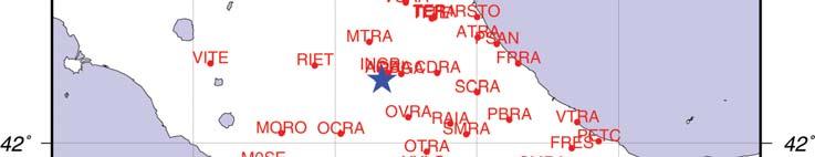
42 Horizontal displacements map
43 Horizontal displacements map No smooth deformation field but a discontinuity line
44 Separation of rigid motion from deformation BAD SPATIAL INTERPOLATION
45 Separation of rigid motion from deformation BAD SPATIAL INTERPOLATION GOOD SPATIAL INTERPOLATION PIECEWISE INTERPOLATION INVOLVES DISCONTINUITIES = FAULTS!
46 Spatial covariances and interpolation A signal could be isolated, but quite arbitrarily a preliminary clustering of homogeneous areas needed
47 Spatial clustering 1. L Aquila sites: mm W displacements
48 Spatial clustering 1. L Aquila sites: mm W displacements 2. Around them: smaller S-W displacements
49 Spatial clustering 1. L Aquila sites: mm W displacements 2. Around them: smaller S-W displacements 3. East region: 2-30 mm NE displacements
50 Spatial clustering 1. L Aquila sites : mm W displacements 2. Around them: smaller S-W displacements 3. East region: 2-30 mm NE displacements 4. Around it: no significant displacements, but consistent directions.


51 Spatial clustering 1. L Aquila sites : mm W displacements 2. Around them: smaller S-W displacements 3. East region: 2-30 mm NE displacements 4. Around it: no significant displacements, but consistent directions. 5. No other significant displacements
52 Separation of rigid motion from deformation Horizontal motion of a network on earth surface: rotation o of all the points around an axis with angular velocity v [ ω] x i i x v
53 Separation of rigid motion from deformation Horizontal motion of a network on earth surface: rotation o of all the points around an axis with angular velocity v [ ω] x i i x v can be estimated by minimization of relative kinetic energy of the network ap vv T i i i1,..., P T min Realization of a Realization of a Discrete Tisserand reference system
54 Horizontal analysis in separate regions Probably no significant rotation of networks but differential i displacements up to now no Tisserand analysis but statistics on displacements for the two main regions East (14 stations) ti L Aquila (4 stations) ti (mm) E N 2D (mm) E N 2D Mean Mean Min Min Max Max
55 Vertical displacements
56 Vertical displacements Significant displacements for L Aquila stations: -25, -76, -107, -123 mm No significant ifi displacements in other regions: mean: 0.5 mm, range -3/+3mm
57 Conclusions 6th April earthquake in L Aquila has been accompanied by an extension along an axis oriented NW-SE: L Aquila area and an Eastern Adriatic area interested by significant opposite horizontal displacements
58 Conclusions 6th April earthquake in L Aquila has been accompanied by an extension along an axis oriented NW-SE: L Aquila area and an Eastern Adriatic area interested by significant opposite horizontal displacements Significant gradients in the horizontal displacements of the Eastern Adriatic area L Aquila sites interested by vertical displacements of about 10 cm
59 Future analyses Longer time series, to: increase the populations after the earthquake, analyze the post seismic time series
60 Future analyses Longer time series, to: increase the populations after the earthquake, analyze the post seismic time series More rigorous clustering in separate regions, rigorous Tisserand analysis, geometric analysis in Adriatic region
61 Future analyses Longer time series, to: increase the populations after the earthquake, analyze the post seismic time series More rigorous clustering in separate regions, rigorous Tisserand analysis, geometric analysis in Adriatic region Cross comparison in L Aquila with SAR interferograms
Estimating crustal deformations using GNSS. Riccardo Barzaghi DICA-Politecnico di Milano
 Estimating crustal deformations using GNSS Riccardo Barzaghi DICA-Politecnico di Milano GNSS non-permanent campaigns The local campaigns require a dense GNSS network in a quite small area a careful distribution
E. Calais Purdue University - EAS Department Civil 3273
 E. Calais urdue University - EAS Department Civil 3273 ecalais@purdue.edu Need for a Reference Frame 1. ositions and velocities from geodetic measurements: Are not direct observations, but estimated quantities
Least squares: introduction to the network adjustment
 Least squares: introduction to the network adjustment Experimental evidence and consequences Observations of the same quantity that have been performed at the highest possible accuracy provide different
Data base of Italian velocities and strain rates at permanent GNSS sites. A. Caporali, M. Bertocco, J. Zurutuza, University of Padova
 Data base of Italian velocities and strain rates at permanent GNSS sites A. Caporali, M. Bertocco, J. Zurutuza, University of Padova Outlook Part 1: GNSS data reduction and organization Italian permanent
The April 6 th 2009, L Aquila (Italy) earthquake: DInSAR analysis and seismic source model inversion
 earthquake: DInSAR analysis and seismic source model inversion") ESA ESRIN 30th November - 4th December 2009 Frascati, Italy The April 6 th 2009, L Aquila (Italy) earthquake: DInSAR analysis and seismic source model inversion Simone Atzori, Christian Bignami, Marco
ESA ESRIN 30th November - 4th December 2009 Frascati, Italy The April 6 th 2009, L Aquila (Italy) earthquake: DInSAR analysis and seismic source model inversion Simone Atzori, Christian Bignami, Marco
How GNSS CORS in Japan works for geodetic control and disaster mitigations
 ICG Working Group D Reference Frames, Timing and Applications How GNSS CORS in Japan works for geodetic control and disaster mitigations ICG11, Nov. 7-11, 2016, Sochi, Russia Hiromichi TSUJI Geodetic Observation
Introduction to geodetic VLBI
 Introduction to geodetic VLBI David Mayer Andreas Hellerschmied Johannes Böhm Harald Schuh and Johannes Böhm, Very Long Baseline Interferometry for Geodesy and Astrometry, in Guochang Xu (editor): Sciences
Inversion of Earthquake Rupture Process:Theory and Applications
 Inversion of Earthquake Rupture Process:Theory and Applications Yun-tai CHEN 12 * Yong ZHANG 12 Li-sheng XU 2 1School of the Earth and Space Sciences, Peking University, Beijing 100871 2Institute of Geophysics,
ITRF2014 Et la prise en compte des mouvements non linéaires
 ITRF2014 Et la prise en compte des mouvements non linéaires Zuheir Altamimi, Paul Rebischung, Laurent Métivier, Xavier Collilieux E-mail: zuheir.altamimi@ign.fr ITRF2014 Network Key Points Modelling of
Joint Inversion of GPS site displacements, ocean bottom pressure models and GRACE gravimetry
 Joint Inversion of GPS site displacements, ocean bottom pressure models and GRACE gravimetry Status JIGOG project R. Rietbroek, J. Kusche, Ch. Dahle, F. Flechtner, R. Schmidt, J. Schröter, M.J.F. Jansen,
Current status of the ITRS realization
 Current status of the ITRS realization Input data Principles for datum definition Combination strategies (3 CCs) Some notes on ITRF2005 Next ITRF solution (?) Zuheir Altamimi ITRS PC ITRF Input Data Up
Introduction to Least Squares Adjustment for geodetic VLBI
 Introduction to Least Squares Adjustment for geodetic VLBI Matthias Schartner a, David Mayer a a TU Wien, Department of Geodesy and Geoinformation Least Squares Adjustment why? observation is τ (baseline)
Atmospheric Phase Screen (APS) estimation and modeling for radar interferometry
 estimation and modeling for radar interferometry") Atmospheric Phase Screen (APS) estimation and modeling for radar interferometry Ramon Hanssen¹, Alessandro Ferretti², Marco Bianchi², Rossen Grebenitcharsky¹, Frank Kleijer¹, Ayman Elawar¹ ¹ Delft University
Atmospheric Phase Screen (APS) estimation and modeling for radar interferometry Ramon Hanssen¹, Alessandro Ferretti², Marco Bianchi², Rossen Grebenitcharsky¹, Frank Kleijer¹, Ayman Elawar¹ ¹ Delft University
GEODETIC NETWORK OF SAUDI ARABIA AND FIDUCIAL STATIONS. GFN OF Saudi Arabia in Based on ITRF2000 Datum
 STUDIES OF TECTONIC MOVEMENTS IN SAUDI ARABIA USING CORS M. Al Rajhi, Ali Al Omar, R. Yanar, F. Kartal, K. Eren, SUBJECT TO TALKS BACKGROUND GEODETIC NETWORK OF SAUDI ARABIA AND FIDUCIAL STATIONS GFN OF
Low-Latency Earthquake Displacement Fields for Tsunami Early Warning and Rapid Response Support
 Low-Latency Earthquake Displacement Fields for Tsunami Early Warning and Rapid Response Support Hans-Peter Plag, Geoffrey Blewitt Nevada Bureau of Mines and Geology and Seismological Laboratory University
The International Terrestrial Reference System and ETRS89: Part I : General concepts
 The International Terrestrial Reference System and ETRS89: Part I : General concepts Zuheir ALTAMIMI Laboratoire de Recherche en Géodésie Institut national de l information géographique et forestière (IGN),
Modern Navigation. Thomas Herring
 12.215 Modern Navigation Thomas Herring Basic Statistics Summary of last class Statistical description and parameters Probability distributions Descriptions: expectations, variances, moments Covariances
Between Seismology and Seismic Design
 Between Seismology and Seismic Design Prof. Dipartimento di Ingegneria Civile e Ambientale, Politecnico di Milano Milano, 10 dicembre 2013 Outline 2 Seismic hazard analysis for critical facilities SIGMA
A. Barbu, J. Laurent-Varin, F. Perosanz, F. Mercier and J. Marty. AVENUE project. June, 20
 Efficient QR Sequential Least Square algorithm for high frequency GNSS Precise Point Positioning A. Barbu, J. Laurent-Varin, F. Perosanz, F. Mercier and J. Marty AVENUE project June, 20 A. Barbu, J. Laurent-Varin,
Principles of the Global Positioning System Lecture 18" Mathematical models in GPS" Mathematical models used in GPS"
 12.540 Principles of the Global Positioning System Lecture 18" Prof. Thomas Herring" Room 54-820A; 253-5941" tah@mit.edu" http://geoweb.mit.edu/~tah/12.540 " Mathematical models in GPS" Review assignment
Actual Continuous Kinematic Model (ACKIM) of the Earth s Crust based on ITRF2014
 of the Earth s Crust based on ITRF2014") Actual Continuous Kinematic Model (ACKIM) of the Earth s Crust based on ITRF2014 Hermann Drewes Technische Universität München Joint Scientific Assembly of the International Association of Geodesy and
Actual Continuous Kinematic Model (ACKIM) of the Earth s Crust based on ITRF2014 Hermann Drewes Technische Universität München Joint Scientific Assembly of the International Association of Geodesy and
The International Terrestrial Reference System and ETRS89: Part II : ITRS & ETRS89 relationship
 The International Terrestrial Reference System and ETRS89: Part II : ITRS & ETRS89 relationship Zuheir ALTAMIMI Laboratoire de Recherche en Géodésie Institut national de l information géographique et forestière
Can geodetic strain rate be useful in seismic hazard studies?
 Can geodetic strain rate be useful in seismic hazard studies? F. Riguzzi 1, R. Devoti 1, G. Pietrantonio 1, M. Crespi 2, C. Doglioni 2, A.R. Pisani 1 Istituto Nazionale di Geofisica e Vulcanologia 2 Università
NTUA, Faculty of Rural and Surveying Engineering, Dionysos Satellite Observatory, Higher Geodesy Laboratory NOA, Institute of Geodynamics 1
 NOA, Institute of Geodynamics 1 Crustal Deformation from GPS measurements at the Ionian Sea : Preliminary Results Anastasiou 1 D., Paradissis 1 D., Ganas 2 A., Marinou 1 A., Papazissi 1 K., Drakatos 2
Frequent epoch reference frames instead of instant station positions and constant velocities
 Deutsches Geodätisches Forschungsinstitut Technische Universität München (DGFI-TUM) Frequent epoch reference frames instead of instant station positions and constant velocities Hermann Drewes Deutsches
Recent GNSS Developments and Reference Frame Issues in Turkey. Onur LENK and Bahadir AKTUĞ
 Recent GNSS Developments and Reference Frame Issues in Turkey Onur LENK and Bahadir AKTUĞ General Command of Mapping onur.lenk lenk@hgk.mil.tr 1/31 GPS STUDIES İN TURKEY date back to early 1990s geodynamics-oriented
Strain analysis.
 Strain analysis ecalais@purdue.edu Plates vs. continuum Gordon and Stein, 1991 Most plates are rigid at the until know we have studied a purely discontinuous approach where plates are
INGV. Giuseppe Pezzo. Istituto Nazionale di Geofisica e Vulcanologia, CNT, Roma. Sessione 1.1: Terremoti e le loro faglie
 Giuseppe Pezzo Istituto Nazionale di Geofisica e Vulcanologia, CNT, Roma giuseppe.pezzo@ingv.it The study of surface deformation is one of the most important topics to improve the knowledge of the deep
Combining InSAR, Levelling and GNSS for the Estimation of 3D Surface Displacements
 Combining InSAR, Levelling and GNSS for the Estimation of 3D Surface Displacements Thomas Fuhrmann (1), Miguel Caro Cuenca (2), Freek van Leijen (3), Malte Westerhaus (1), Ramon Hanssen (3), Bernhard Heck
to: Interseismic strain accumulation and the earthquake potential on the southern San
 Supplementary material to: Interseismic strain accumulation and the earthquake potential on the southern San Andreas fault system by Yuri Fialko Methods The San Bernardino-Coachella Valley segment of the
Realizing a geodetic reference frame using GNSS in the presence of crustal deformations: The case of Greece
 Realizing a geodetic reference frame using GNSS in the presence of crustal deformations: The case of Greece M. Gianniou National Cadastre and Mapping Agency S.A. Outline 1. Introduction 2. Deformation
Common Realization of Terrestrial and Celestial Reference Frame
 Common Realization of Terrestrial and Celestial Reference Frame M. Seitz, R. Heinkelmann, P. Steigenberger, T. Artz Abstract The realization of the International Celestial Reference System (ICRS) and the
Principles of the Global Positioning System Lecture 11
 12.540 Principles of the Global Positioning System Lecture 11 Prof. Thomas Herring http://geoweb.mit.edu/~tah/12.540 Statistical approach to estimation Summary Look at estimation from statistical point
Chapter 13. Multiple Regression and Model Building
 Chapter 13 Multiple Regression and Model Building Multiple Regression Models The General Multiple Regression Model y x x x 0 1 1 2 2... k k y is the dependent variable x, x,..., x 1 2 k the model are the
The problem (1/2) GPS velocity fields in plate boundary zones are very smooth. What does this smoothness hide?
 GPS velocity fields in plate boundary zones are very smooth. What does this smoothness hide?") Block models The problem (1/2) GPS velocity fields in plate boundary zones are very smooth Figure from Tom Herring, MIT What does this smoothness hide? Continuous deformation? Rigid block motions, with
Block models The problem (1/2) GPS velocity fields in plate boundary zones are very smooth Figure from Tom Herring, MIT What does this smoothness hide? Continuous deformation? Rigid block motions, with
Global reference systems and Earth rotation
 current realizations and scientific problems Aleksander Brzeziński 1,2, Tomasz Liwosz 1, Jerzy Rogowski 1, Jan Kryński 3 1 Department of Geodesy and Geodetic Astronomy Warsaw University of Technology 2
Characteristics of GPS ZTD products. Jan Douša EUREF Analysis Centre Workshop
 Characteristics of GPS ZTD products Jan Douša EUREF Analysis Centre Workshop March 15-16, 2006 Outline ZTD and PWV products Stragegy changes GPS constellation effect solution characteristics ZTD differences
Lecture 10 Polynomial interpolation
 Lecture 10 Polynomial interpolation Weinan E 1,2 and Tiejun Li 2 1 Department of Mathematics, Princeton University, weinan@princeton.edu 2 School of Mathematical Sciences, Peking University, tieli@pku.edu.cn
3D temporal evolution of displacements recorded on Mt. Etna from the 2007 to 2010 through the SISTEM method
 3D temporal evolution of displacements recorded on Mt. Etna from the 2007 to 2010 through the SISTEM method Bonforte A., Guglielmino F.,, Puglisi G. INGV Istituto Nazionale di Gofisica e vulcanologia Osservatorio
PLATE DEFORMATION - 2
 H4.SMR/1775-24 "8th Workshop on Three-Dimensional Modelling of Seismic Waves Generation, Propagation and their Inversion" 25 September - 7 October 2006 PLATE DEFORMATION - 2 Roberto Sabadini Dipartimento
Case Study of Japan: Crustal deformation monitoring with GNSS and InSAR
 Technical Seminar Reference Frame in Practice, Case Study of Japan: Crustal deformation monitoring with GNSS and InSAR Basara Miyahara miyahara-b96ip@milt.go.jp Geospatial Information Authority of Japan
The Impact of the 2010 Darfield (Canterbury) Earthquake on the Geodetic Infrastructure in New Zealand 1
 Earthquake on the Geodetic Infrastructure in New Zealand 1") The Impact of the 2010 Darfield (Canterbury) Earthquake on the Geodetic Infrastructure in New Zealand 1 Graeme BLICK, John BEAVAN, Chris CROOK, Nic DONNELLY Keywords: Darfield Earthquake, control, survey,
The Impact of the 2010 Darfield (Canterbury) Earthquake on the Geodetic Infrastructure in New Zealand 1 Graeme BLICK, John BEAVAN, Chris CROOK, Nic DONNELLY Keywords: Darfield Earthquake, control, survey,
log 4 0.7m log m Seismic Analysis of Structures by TK Dutta, Civil Department, IIT Delhi, New Delhi. Module 1 Seismology Exercise Problems :
 Seismic Analysis of Structures by TK Dutta, Civil Department, IIT Delhi, New Delhi. Module Seismology Exercise Problems :.4. Estimate the probabilities of surface rupture length, rupture area and maximum
Summary so far. Geological structures Earthquakes and their mechanisms Continuous versus block-like behavior Link with dynamics?
 Summary so far Geodetic measurements velocities velocity gradient tensor (spatial derivatives of velocity) Velocity gradient tensor = strain rate (sym.) + rotation rate (antisym.) Strain rate tensor can
Interpolation and Polynomial Approximation I
 Interpolation and Polynomial Approximation I If f (n) (x), n are available, Taylor polynomial is an approximation: f (x) = f (x 0 )+f (x 0 )(x x 0 )+ 1 2! f (x 0 )(x x 0 ) 2 + Example: e x = 1 + x 1! +
Summary of the 2012 Global Geophysical Fluid Center Workshop
 Summary of the 2012 Global Geophysical Fluid Center Workshop T. van Dam (Uni. Lux), J. Ray (NGS/NOAA), X. Collilieux (IGN) Introduction Review the history of the GGFC Discuss the 2012 Workshop Review recommendations
The Potential of High Resolution Satellite Interferometry for Monitoring Enhanced Oil Recovery
 The Potential of High Resolution Satellite Interferometry for Monitoring Enhanced Oil Recovery Urs Wegmüller a Lutz Petrat b Karsten Zimmermann c Issa al Quseimi d 1 Introduction Over the last years land
Roots and Coefficients Polynomials Preliminary Maths Extension 1
 Preliminary Maths Extension Question If, and are the roots of x 5x x 0, find the following. (d) (e) Question If p, q and r are the roots of x x x 4 0, evaluate the following. pq r pq qr rp p q q r r p
of the 7 stations. In case the number of daily ozone maxima in a month is less than 15, the corresponding monthly mean was not computed, being treated
 Spatial Trends and Spatial Extremes in South Korean Ozone Seokhoon Yun University of Suwon, Department of Applied Statistics Suwon, Kyonggi-do 445-74 South Korea syun@mail.suwon.ac.kr Richard L. Smith
3.3 Analysis Coordinator
 1. Introduction 2. Analysis of ITRF2014 post-seismic parameterization In this report we outline the activities of the Analysis Coordinator during 2015. The main activities were analysis of the ITRF2014
Operational Earthquake Forecasting in Italy: perspectives and the role of CSEP activities
 Operational Earthquake Forecasting in Italy: perspectives and the role of CSEP activities Warner Marzocchi, Istituto Nazionale di Geofisica e Vulcanologia, Italy The research was developed partially within
Monitoring and Analysis
 Monitoring and Analysis of the Italian Permanent Network RDN of GNSS stations G. Farolfi Symposium EUREF 2010 Gävle, Sweden 2th - 5th june 1 Outlook Data and features of the RDN network Processing Strategy
Preliminary Examination in Numerical Analysis
 Department of Applied Mathematics Preliminary Examination in Numerical Analysis August 7, 06, 0 am pm. Submit solutions to four (and no more) of the following six problems. Show all your work, and justify
Publ. Astron. Obs. Belgrade No. 91 (2012), REALIZATION OF ETRF2000 AS A NEW TERRESTRIAL REFERENCE FRAME IN REPUBLIC OF SERBIA
, REALIZATION OF ETRF2000 AS A NEW TERRESTRIAL REFERENCE FRAME IN REPUBLIC OF SERBIA") Publ. Astron. Obs. Belgrade No. 91 (2012), 199-206 Contributed paper REALIZATION OF ETRF2000 AS A NEW TERRESTRIAL REFERENCE FRAME IN REPUBLIC OF SERBIA D. BLAGOJEVIĆ and V. VASILIĆ Faculty of Civil Engineering,
Publ. Astron. Obs. Belgrade No. 91 (2012), 199-206 Contributed paper REALIZATION OF ETRF2000 AS A NEW TERRESTRIAL REFERENCE FRAME IN REPUBLIC OF SERBIA D. BLAGOJEVIĆ and V. VASILIĆ Faculty of Civil Engineering,
South Pacific Sea Level and Climate Monitoring Project
 G E O S C I E N C E A U S T R A L I A South Pacific Sea Level and Climate Monitoring Project GPS Coordinate Time Series, 2007.0 to Manoj N. Deo, Guorong Hu, John Dawson and Minghai Jia Record 2012/34 GeoCat
Large deflection analysis of planar solids based on the Finite Particle Method
 yuying@uiuc.edu 10 th US National Congress on Computational Mechanics Large deflection analysis of planar solids based on the Finite Particle Method 1, 2 Presenter: Ying Yu Advisors: Prof. Glaucio H. Paulino
Very Long Baseline Interferometry for Geodesy and Astrometry
 Very Long Baseline Interferometry for Geodesy and Astrometry Johannes Böhm Harald Schuh and Johannes Böhm, Very Long Baseline Interferometry for Geodesy and Astrometry, in Guochang Xu (editor): Sciences
The Victorian Seismic Zone 2011 GNSS Campaign Data Analysis
 G E O S C I E N C E A U S T R A L I A The Victorian Seismic Zone 2011 GNSS Campaign Data Analysis G. Hu Record 2012/38 GeoCat # 74005 APPLYING GEOSCIENCE TO AUSTRALIA S MOST IMPORTANT CHALLENGES The Victorian
Separating Tectonic, Magmatic, Hydrological, and Landslide Signals in GPS Measurements near Lake Tahoe, Nevada-California
 Separating Tectonic, Magmatic, Hydrological, and Landslide Signals in GPS Measurements near Lake Tahoe, Nevada-California Geoffrey Blewitt, Corné Kreemer, William C. Hammond, & Hans-Peter Plag NV Geodetic
Call for space geodetic solutions corrected for non-tidal atmospheric loading (NT-ATML) at the observation level
 at the observation level") Call for space geodetic solutions corrected for non-tidal atmospheric loading (NT-ATML) at the observation level Xavier Collilieux, Tonie van Dam, Zuheir Altamimi Outline: Context Why correcting for non-tidal
Call for space geodetic solutions corrected for non-tidal atmospheric loading (NT-ATML) at the observation level Xavier Collilieux, Tonie van Dam, Zuheir Altamimi Outline: Context Why correcting for non-tidal
Basics of the modelling of the ground deformations produced by an earthquake. EO Summer School 2014 Frascati August 13 Pierre Briole
 Basics of the modelling of the ground deformations produced by an earthquake EO Summer School 2014 Frascati August 13 Pierre Briole Content Earthquakes and faults Examples of SAR interferograms of earthquakes
Dynamic data processing recursive least-squares
 Dynamic data processing recursive least-squares Dynamic data processing recursive least-squares Delft University of Technology Department of Mathematical Geodesy and Positioning VSSD Series on Mathematical
Geodynamic Pattern of the West Bohemia during the October 2008 Earthquake Swarm
 10th Czech-Polish Workshop on RECENT GEODYNAMICS OF THE SUDETEN AND ADJACENT AREAS Szklarska Poręba, November 5-7, 2009 Geodynamic Pattern of the West Bohemia during the October 2008 Earthquake Swarm Vladimír
IGS POLAR MOTION MEASUREMENTS
 STATUS & PROSPECTS FOR IGS POLAR MOTION MEASUREMENTS Why does the IGS care about EOPs? observations, predictions, & IGS product table Recent pole & pole rate accuracies & error sources Rapid & Final products
Application and verification of ECMWF products 2013
 Application and verification of EMWF products 2013 Hellenic National Meteorological Service (HNMS) Flora Gofa and Theodora Tzeferi 1. Summary of major highlights In order to determine the quality of the
Moment Area Method. 1) Read
 Read") Moment Area Method Lesson Objectives: 1) Identify the formulation and sign conventions associated with the Moment Area method. 2) Derive the Moment Area method theorems using mechanics and mathematics.
Moment Area Method Lesson Objectives: 1) Identify the formulation and sign conventions associated with the Moment Area method. 2) Derive the Moment Area method theorems using mechanics and mathematics.
Stochastic Processes
 Stochastic Processes Stochastic Process Non Formal Definition: Non formal: A stochastic process (random process) is the opposite of a deterministic process such as one defined by a differential equation.
Uncertainty analysis of heliostat alignment at the Sandia solar field
 Available online at www.sciencedirect.com Energy Procedia 00 (2013) 000 000 www.elsevier.com/locate/procedia SolarPACES 2013 Uncertainty analysis of heliostat alignment at the Sandia solar field Rachel
TREND EXTRACTION FROM TIME SERIES WITH STRUCTURAL BREAKS AND MISSING OBSERVATIONS
 J. Japan Statist. Soc. Vol. 3 No. 5 9 TREND EXTRACTION FROM TIME SERIES WITH STRUCTURAL BREAKS AND MISSING OBSERVATIONS Ekkehart Schlicht* Trend extraction from time series is often performed by using
Lateral extrusion and tectonic escape in Ilan Plain of northeastern Taiwan
 Lateral extrusion and tectonic escape in Ilan Plain of northeastern Taiwan Angelier, J., Chang, T.Y., Hu, J.C., Chang, C.P., Siame, L., Lee, J.C., Deffontaines, B., Chu, H.T, Lu, C.Y., Does extrusion occur
Noise Characteristics in High Precision GPS Positioning
 Noise Characteristics in High Precision GPS Positioning A.R. Amiri-Simkooei, C.C.J.M. Tiberius, P.J.G. Teunissen, Delft Institute of Earth Observation and Space systems (DEOS), Delft University of Technology,
The March 11, 2011, Tohoku-oki earthquake (Japan): surface displacement and source modelling
: surface displacement and source modelling") The March 11, 2011, Tohoku-oki earthquake (Japan): surface displacement and source modelling Salvatore Stramondo Bignami C., Borgstrom S., Chini M., Guglielmino F., Melini D., Puglisi G., Siniscalchi V.,
The March 11, 2011, Tohoku-oki earthquake (Japan): surface displacement and source modelling Salvatore Stramondo Bignami C., Borgstrom S., Chini M., Guglielmino F., Melini D., Puglisi G., Siniscalchi V.,
Preparation for the ITRF2013. Zuheir Altamimi Xavier Collilieux Laurent Métivier IGN, France
 Preparation for the ITRF2013 Zuheir Altamimi Xavier Collilieux Laurent Métivier IGN, France 1 Outline Introduction Solicited solutions Analysis Strategy Preparation for the ITRF2013: Combination tests
GPS Strain & Earthquakes Unit 5: 2014 South Napa earthquake GPS strain analysis student exercise
 GPS Strain & Earthquakes Unit 5: 2014 South Napa earthquake GPS strain analysis student exercise Strain Analysis Introduction Name: The earthquake cycle can be viewed as a process of slow strain accumulation
Lecture 14: Strain Examples. GEOS 655 Tectonic Geodesy Jeff Freymueller
 Lecture 14: Strain Examples GEOS 655 Tectonic Geodesy Jeff Freymueller A Worked Example Consider this case of pure shear deformation, and two vectors dx 1 and dx 2. How do they rotate? We ll look at vector
Introduction. Semivariogram Cloud
 Introduction Data: set of n attribute measurements {z(s i ), i = 1,, n}, available at n sample locations {s i, i = 1,, n} Objectives: Slide 1 quantify spatial auto-correlation, or attribute dissimilarity
TECTONIC MOVEMENTS MONITORING OF SUDETIC MARGINAL FAULT USING SHORT GPS BASELINES
 POSTER PAPER SESSION TECTONIC MOVEMENTS MONITORING OF SUDETIC MARGINAL FAULT USING SHORT GPS ASELINES ernard Kontny Department of Geodesy and Photogrammetry Agricultural University of Wroclaw, Poland Abstract
of other regional earthquakes (e.g. Zoback and Zoback, 1980). I also want to find out
. I also want to find out") 4. Focal Mechanism Solutions A way to investigate source properties of the 2001 sequence is to attempt finding well-constrained focal mechanism solutions to determine if they are consistent with those
4. Focal Mechanism Solutions A way to investigate source properties of the 2001 sequence is to attempt finding well-constrained focal mechanism solutions to determine if they are consistent with those
SIRGAS: Basis for Geosciences, Geodata, and Navigation in Latin America
 SIRGAS: Basis for Geosciences, Geodata, and Navigation in Latin America Claudio Brunini President of SIRGAS Universidad Nacional de La Plata, Argentina María Virginia Mackern President of SIRGAS/WG-I:
Analysis effects in IGS station motion time series P. Rebischung, X. Collilieux, T. van Dam, J. Ray, Z. Altamimi
 Analysis effects in IGS station motion time series P. Rebischung, X. Collilieux, T. van Dam, J. Ray, Z. Altamimi IGS workshop 2012, Olsztyn, Poland 1 Background: expectedsignals IGS station position time
Università degli Studi di Bari. mechanics 1. Load system determination. Joint load. Stress-strain distribution. Biological response 2/45 3/45
 Università degli Studi di Bari mechanics 1 Load system determination Joint load Stress-strain distribution Biological response 2/45 3/45 ? 4/45 The human body machine Energy transformation Work development
Performance based Engineering
 Probability based based Methods in Performance based Engineering Fatemeh Jalayer University of Naples Federico II A RELAXED WORKSHOP ON PERFORMANCE-BASED EARTHQUAKE ENGINEERING July 2-4 2009 The characterization
Non-Linear Finite Element Methods in Solid Mechanics Attilio Frangi, Politecnico di Milano, February 17, 2017, Lesson 5
 Non-Linear Finite Element Methods in Solid Mechanics Attilio Frangi, attilio.frangi@polimi.it Politecnico di Milano, February 17, 2017, Lesson 5 1 Politecnico di Milano, February 17, 2017, Lesson 5 2 Outline
Omm Al-Qura University Dr. Abdulsalam Ai LECTURE OUTLINE CHAPTER 3. Vectors in Physics
 LECTURE OUTLINE CHAPTER 3 Vectors in Physics 3-1 Scalars Versus Vectors Scalar a numerical value (number with units). May be positive or negative. Examples: temperature, speed, height, and mass. Vector
FORMAT FOR TECHNICAL PAPERS
 TOWARDS A MODERNIZED GEODETIC DATUM FOR NEPAL: OPTIONS FOR DEVELOPING AN ACCURATE TERRESTRIAL REFERENCE FRAME FOLLOWING THE APRIL 25, 2015 MW7.8 GORKHA EARTHQUAKE Chris PEARSON 1, Niraj MANANDHA 2 ABSTRACT
crustal volume of the swarm. This initiated interest and concern that another
 3. Earthquae locations Data from permanent seismic networs located the 2001 Enola mainshoc within the crustal volume of the 1982-84 swarm. This initiated interest and concern that another 1982-lie sequence
Dynamic Approaches: The Hidden Markov Model
 Dynamic Approaches: The Hidden Markov Model Davide Bacciu Dipartimento di Informatica Università di Pisa bacciu@di.unipi.it Machine Learning: Neural Networks and Advanced Models (AA2) Inference as Message
Bayesian dynamic modeling for large space-time weather datasets using Gaussian predictive processes
 Bayesian dynamic modeling for large space-time weather datasets using Gaussian predictive processes Andrew O. Finley Department of Forestry & Department of Geography, Michigan State University, Lansing
A priori gradients in the analysis of GPS and VLBI observations
 A priori gradients in the analysis of GPS and VLBI observations Peter Steigenberger GeoForschungsZentrum Potsdam Volker Tesmer Deutsche Geodätisches Forschungsinstitut, München Johannes Boehm Institute
Understanding Seismic Hazard Needs for Infrastructure Risk Analysis: Lessons from SYNER-G
 Systemic Seismic Vulnerability and Risk Analysis for Buildings, Lifeline Networks and Infrastructures Safety Gain Understanding Seismic Hazard Needs for Infrastructure Risk Analysis: Lessons from SYNER-G
EXAMINATION ON CONSECUTIVE RUPTURING OF TWO CLOSE FAULTS BY DYNAMIC SIMULATION
 EXAMINATION ON CONSECUTIVE RUPTURING OF TWO CLOSE FAULTS BY DYNAMIC SIMULATION M. Muto 1, K. Dan 1, H. Torita 1, Y. Ohashi 1, and Y. Kase 2 1 Ohsaki Research Institute, Inc., Tokyo, Japan 2 National Institute
UNCERTAINTY IN TACHEOMETRIC MEASUREMENT OF CONVERGENCES IN TUNNELS
 3rd IAG / 1th FIG Symposium, Baden, May -4, 006 UNCERTAINTY IN TACHEOMETRIC MEASUREMENT OF CONVERGENCES IN TUNNELS Maria João Henriques João Casaca National Laboratory for Civil Engineering Lisbon, Portugal
Originally published as:
 Originally published as: Seitz M., Steigenberger P., Artz T. (2xx) Consistent adjustment of combined terrestrial and celestial reference frames, Earth on the Edge: Science for a Sustainable Planet, IAG
Least Absolute Value vs. Least Squares Estimation and Inference Procedures in Regression Models with Asymmetric Error Distributions
 Journal of Modern Applied Statistical Methods Volume 8 Issue 1 Article 13 5-1-2009 Least Absolute Value vs. Least Squares Estimation and Inference Procedures in Regression Models with Asymmetric Error
NUMERICAL SOLUTION OF DOPANT DIFFUSION EQUATIONS. M.J. Bainss, C.P. Please and P.K. Sweby. Mathematics Department University of Reading, Berkshire.
 271 NUMERICAL SOLUTION OF DOPANT DIFFUSION EQUATIONS M.J. Bainss, C.P. Please and P.K. Sweby. Mathematics Department University of Reading, Berkshire. 272 SUMMARY A description is given of the application
VALIDATION OF THE PERMANENT SCATTERERS TECHNIQUE IN URBAN AREAS
 VALIDATION OF THE PERMANENT SCATTERERS TECHNIQUE IN URBAN AREAS Alessandro Ferretti, Claudio Prati, Fabio Rocca, Carlo Colesanti Dipartimento di Elettonica e Informazione Politecnico di Milano Piazza L.
The Kinematic Reference Frame for ITRF
 The Kinematic Reference Frame for ITRF Hermann Drewes and Barbara Meisel Deutsches Geodätisches Forschungsinstitut Munich, Germany IERS Workshop, Potsdam, 10.10.2005 Motivation and Objectives The kinematic
University of Athens School of Physics Atmospheric Modeling and Weather Forecasting Group
 University of Athens School of Physics Atmospheric Modeling and Weather Forecasting Group http://forecast.uoa.gr Data Assimilation in WAM System operations and validation G. Kallos, G. Galanis and G. Emmanouil
Geodesy (InSAR, GPS, Gravity) and Big Earthquakes
 and Big Earthquakes") Geodesy (InSAR, GPS, Gravity) and Big Earthquakes Mathew Pritchard Teh-Ru A. Song Yuri Fialko Luis Rivera Mark Simons UJNR Earthquake Research Panel, Morioka, Japan - Nov 6, 2002 Goals Accurate and high
Geodesy (InSAR, GPS, Gravity) and Big Earthquakes Mathew Pritchard Teh-Ru A. Song Yuri Fialko Luis Rivera Mark Simons UJNR Earthquake Research Panel, Morioka, Japan - Nov 6, 2002 Goals Accurate and high
Widespread Ground Motion Distribution Caused by Rupture Directivity during the 2015 Gorkha, Nepal Earthquake
 Widespread Ground Motion Distribution Caused by Rupture Directivity during the 2015 Gorkha, Nepal Earthquake Kazuki Koketsu 1, Hiroe Miyake 2, Srinagesh Davuluri 3 and Soma Nath Sapkota 4 1. Corresponding