Lyme Regis. Environmental Improvements Phase 2. Securing the future of Lyme Regis
|
|
|
- Ronald Ross
- 5 years ago
- Views:
Transcription

1 Lyme Regis Environmental Improvements Phase 2 Securing the future of Lyme Regis


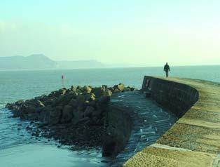
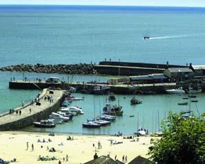
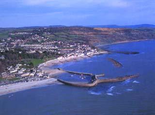
2 Wave attack on Marine Parade The spectacular scenery around Lyme Regis is a result of erosion by the sea and landsliding of local cliffs. Looking after Lyme Regis Land stability problems are nothing new as this picture from 1926 shows. Lyme Regis sits on one of the most unstable and actively eroding stretches of coastline in the country. Over the centuries a long line of structures, such as the famous Cobb and other sea walls, have been built to try to offer some protection against attack by the sea and give increased stability for the town. Aims The environmental improvements scheme is phase 2 of a long-term plan to offer security for homes and businesses in the town. Phase 1 (right) was completed in 1995 and were awarded the Secretary of State's Special Commendation for Environmental Excellence at the British Construction Industry awards. The works also won a 1997 Civic Trust Award for Outstanding Contribution to the Quality and Appearance of the Environment and helped the district council gain beacon status in The council also successfully completed 1.4 million stabilisation works at East Cliff, Church Cliff and land behind the harbour during the winter of Benefits Although some inconvenience is inevitable while work takes place, the benefits are huge, offering long-term protection against destructive landslides and coastal erosion. The scheme also has additional benefits, including: o More sand and shingle on the beach o New promenade o Increased shelter around the harbour o Improved ramp access to the gardens and Holmbush Car Park o Re-landscaped public gardens with more walks o Improvements to Cobb Road o Access along the beach - even at high tide Left centre photograph on front cover Kate Friar 2003 Phase 1 works provided a new promenade for the town. The council has involved local people throughout the planning, design and construction of the scheme. The depleted beach (above) will be replenished to protect the foreshore from attack by sea.


3 The scheme The scheme is made up of four main parts: 1. Foreshore works o Extra sand and shingle will be put on the beach to absorb wave energy - protects sea walls and the foreshore from being eroded by the sea. o Extension to rock armour (called Beacon Rocks) at the end of the Cobb - shelters the foreshore from powerful waves and helps to stop the new beach from being washed away. o Realignment of North Wall Rockery, new jetties at Lister Gardens and Cobb Gate plus new seawall and promenade - to protect the foreshore and stop the new beach from being washed away. 2. Land stabilisation work o Ground behind the foreshore stabilised to help prevent landslides - soil nailing and 1,150 bored piles pin unstable ground to firmer ground below. o New drainage system including boreholes and trenches to disperse water - a major factor in causing land instability. o Slope regrading, removal of landslide debris and building of soil buttresses at the back of the gardens to support the hill behind. 3. Cobb Road This map shows the phase 2 scheme layout. o Scheme includes Cobb Road improvements - with Dorset County Council s contribution of approximately 1 million. 4. Landscape design works o Langmoor and Lister Gardens reinstated after land stabilisation works - includes new ramp access, woodland walk, improved footpath links and new planting scheme Public gardens in Lyme Regis improved and enhanced following engineering work to stabilise the town. Over 1,000 piles will be inserted into the ground at Lyme Regis as part of the work. Beacon Rocks at the end of the Cobb will double in length. This artist's impression shows how it looks before (left) and after (right) work.
4 Why is Lyme under threat? The highly active nature of the coastline can be seen along local cliffs on either side of the town. Without hard engineering schemes Lyme Regis would gradually be eaten away by the sea and afflicted by destructive landslides - threatening homes, businesses and the lives of local people and visitors alike. This diagram shows a simplified cross-section of the land at Lyme Regis and the processes that make it unstable The rock deep below the town is made up of layers of strong limestone with shale in between. This bedrock is stable and solid. 2. On top of the bedrock there are unstable slippery clays, green sand plus other muddy and sandy material. This moves over the strong limestone layers below to form landslides. 3. The layers slope down towards the sea making it easier for the unstable top layer to move over them - particularly during wet weather. 4. The sea eats away at the bottom of landslides and undermines the land. This prevents a toe or plug forming - and means that the unstable material keeps moving. 5. Old coastal defence built to protect the town have been undermined by the sea. 6. Localised shallow landslips take place in areas of weakness - usually in arc shapes. 7. Buildings subside as the land moves. 8. Houses become damaged due to movement of the land behind. 9. The beach is depleted, offering little protection against the sea. 10. Houses under threat as the landslides expand inland.


5 It's good to talk The views of the local community have been very important in creating the scheme and extensive public consultation has been carried out, including selection of the final scheme option. The district council continues to talk, listen and respond to local people during the work programme, which started in spring 2005 and is set to last around two years. During that time the council aims to minimise disruption wherever possible. That includes keeping the main beach and at least one of the town's two gardens open during the main summer six-week holiday season. The council meets with town advisory groups on a regular basis to discuss the impact of the works and attends the Lyme Regis Coastal Forum to report on progress. The council also produces an update newsletter, which is delivered to houses in the town. How to find out more Local people and visitors can call into a specially built exhibition centre on the foreshore to find out more about the works and any latest news. Concerns or questions can be directed to an Information Officer, by calling or by ing engineers@westdorset-dc.gov.uk Latest updates about the engineering works can also be found on the website Local people watched prospective schemes being put through their paces at the HR Wallingford testing facility in Oxfordshire. Shopping list Rock armour 36,000 tonnes Beach shingle 71,000 tonnes Beach sand 41,000 tonnes Drainage material 7,500 tonnes Masonry 400 tonnes Piles 1,150 Drainage 2,300 metres Jetties 110 metres New seawall 250 metres Planting 7,500 square metres Working together to achieve success The scheme is promoted and managed by West Dorset District Council working with the following partners and organisations: Defra* Lyme Regis Town Council Dorset County Council Mowlem Civil Engineering High Point Rendel HR Wallingford Environs Partnership Funders Principal landowners Cobb Road improvements Main contractors Designers Hydraulics consultants Landscape Designers The scheme will stop homes from being destroyed. * Department for the Environment, Food and Rural Affairs Securing the future of Lyme Regis Produced by West Dorset District Council Communications Team 2005
Hard Engineering: Lyme Regis
 Hard Engineering: Lyme Regis By The British Geographer Situation Lyme Regis, with a population of 4400 is located in the centre of the Heritage Jurassic Coast in Dorset, South England. It is exposed to
Looking after Lyme Regis
 Looking after Lyme Regis Lyme Regis sits on one of the most unstable stretches of coastline in the country. The highly active and unstable nature of the land which Lyme Regis is built upon can easily be
Coastal Management on the Isle of Wight
 Coastal Management on the Isle of Wight Setting the scene The Isle of Wight has 65 miles of spectacular coastline, 28 miles of which are designated Heritage Coast. This varied coastline is one of the Island
GCSE 4242/02 GEOGRAPHY (Specification B) FOUNDATION TIER UNIT 2 SECTION B
 FOUNDATION TIER UNIT 2 SECTION B") Surname Centre Number Candidate Number Other Names 0 GCSE 4242/02 GEOGRAPHY (Specification B) FOUNDATION TIER UNIT 2 SECTION B S15-4242-02 P.M. WEDNESDAY, 3 June 2015 1 hour 30 minutes For s use Part Maximum
Surname Centre Number Candidate Number Other Names 0 GCSE 4242/02 GEOGRAPHY (Specification B) FOUNDATION TIER UNIT 2 SECTION B S15-4242-02 P.M. WEDNESDAY, 3 June 2015 1 hour 30 minutes For s use Part Maximum
26 Coastal erosion and accretion
 26 Coastal erosion and accretion 26.1 Rate of erosion and accretion 26.2 Length of protected coastline 26.3 Volume of sand nourishment Fig. 26.1: Coastline dynamics of the South East Baltic region Key
Managing Floods at Boscastle. Learning Objective: Examine the benefits of managing floods
 Managing Floods at Boscastle Learning Objective: Examine the benefits of managing floods Learning Outcomes: Describe how Boscastle has been affected by flooding Explain strategies to reduce the risk Evaluate
Map 2: Cowal Peninsula: Lazaretto Point to Dunoon Harbour North Map Content Descriptions
 Map 2: Cowal Peninsula: Lazaretto Point to Dunoon Harbour North Map Content Descriptions 1. Built Heritage and Archaeology A total of thirteen sites were recorded in the area covered by Map 2. Of these
Geol 117 Lecture 18 Beaches & Coastlines. I. Types of Coastlines A. Definition:
 I. Types of Coastlines A. Definition: 1. Shore = narrow zone where ocean meets land (e.g. beach) 2. Coast is a broad area where both ocean and land processes act a. Includes onshore marshes, dunes, sea
Think about the landforms where you live. How do you think they have changed over time? How do you think they will change in the future?
 reflect All the landforms on Earth have changed over time and continue to change. Many of the changes were caused by wind, moving water, and moving ice. Mountains have grown and shrunk. Rivers have cut
Chapter 7 Case study. Sand dune coastal environment: Studland Bay
 Sand dune coastal environment: Studland Bay Sand dunes are common features of low-lying stretches of coastline in the UK and elsewhere in the world. They form in places where there is a plentiful supply
Climate Change and the Implications for the Management of Coastal Landslides. James Houghton Senior Geotechnical Engineer Isle of Wight Council
 Climate Change and the Implications for the Management of Coastal Landslides James Houghton Senior Geotechnical Engineer Isle of Wight Council Outline Background to landsliding on the Isle of Wight Current
How does erosion happen?
 How does erosion happen? By National Geographic, adapted by Newsela staff on 10.03.17 Word Count 682 Level 830L These rock formations, in Bryce Canyon National Park, Utah, are called hoodoos. Although
Changes to Land 5.7B. landforms: features on the surface of Earth such as mountains, hills, dunes, oceans and rivers
 All the landforms on Earth have changed over time and continue to change. Many of the changes were caused by wind, moving water, and moving ice. Mountains have grown and shrunk. Rivers have cut away land
Map 12: Ayrshire Coast: Doonfoot Beach to Dunure Map Content Descriptions
 Map 12: Ayrshire Coast: Doonfoot Beach to Dunure Map Content Descriptions 1. Built Heritage and Archaeology A total of twenty three sites were located in the area covered by Map 12. Of these seventeen
Physical landscapes River landscapes in the UK
 Physical landscapes River landscapes in the UK The shape of river valleys change s as rivers flow downstream - PROCESSES Erosion Abrasion or corrasion Attrition Hydraulic Action Solution or corrosion Deposition
East Cliff Landslide, Bournemouth
 East Cliff Landslide, Bournemouth Last updated 15:00, 07/06/2016 Surface geology 1:625 000 The blue pin marks the approximate location. On 24 April 2016, the BGS Landslide Response Team received reports
Map 4: Cowal Peninsula: Cluniter to Ardyne Point Map Content Descriptions
 Map 4: Cowal Peninsula: Cluniter to Ardyne Point Map Content Descriptions 1. Built Heritage and Archaeology A total of twenty four sites were recorded in the area covered by Map 4. Of these six were previously
Coasts Key Word Glossary
 Coasts Key Word Glossary Abrasion Also known as corrosion. It is the wearing away of the cliff by sand, fragments of rock and boulders that are being hurled at the cliff by the waves. It causes grinding
3/8/17. #20 - Landslides: Mitigation and Case Histories. Questions for Thought. Questions for Thought
 #20 - Landslides: Mitigation and Case Histories Web Exercise #3 (Volcanoes) Due Wednesday There is a 2-point penalty for every day the assignment is late. Exam 1 Scores Scores and exam key are posted Vaiont
Seaton to Seaton Hole SUMMARY OF PREFERRED PLAN RECOMMENDATIONS AND JUSTIFICATION
 Location reference: Policy Unit reference: Plan: Seaton to Seaton Hole 6a29 and 6a30 SUMMARY OF PREFERRED PLAN RECOMMENDATIONS AND JUSTIFICATION The large number of properties and assets at risk in the
Map 9: Ayrshire Coast: Stevenston Pier to Barassie Map Content Descriptions
 Map 9: Ayrshire Coast: Stevenston Pier to Barassie Map Content Descriptions 1. Built Heritage and Archaeology A total of thirteen sites were recorded in the area covered by Map 9. Of these five were previously
Paper One Living with the Physical Environment. SECTION C Physical Landscapes in UK
 GCSE GEOGRAPHY Revision Questions Paper One Living with the Physical Environment SECTION C Physical Landscapes in UK COASTS Note: questions get progressively more demanding as you move through. Mark schemes
Read Across America. Listen as I read for facts about Volcanoes. In the Shadow of the Volcano
 Read Across America Listen as I read for facts about Volcanoes. In the Shadow of the Volcano Constructive & Destructive Processes Earth s surface is always changing. Blowing wind and flowing water causes
3l NATURAL HAZARDS AND UNSTABLE GROUND
 Page 1 of Section 3l 3l NATURAL HAZARDS AND UNSTABLE GROUND 3l.1 Introduction A natural hazard is the result of natural processes that form, shape and change the environment and interact or potentially
The Coast: Beaches and Shoreline Processes
 1 2 3 4 5 6 7 8 9 The Coast: es and Shoreline Processes Trujillo & Thurman, Chapter 10 Oceanography 101 Chapter Objectives Recognize the various landforms characteristic of beaches and coastal regions.
SHORELINE AND BEACH PROCESSES: PART 2. Implications for Coastal Engineering
 SHORELINE AND BEACH PROCESSES: PART 2 Implications for Coastal Engineering Objectives of the lecture: Part 2 Show examples of coastal engineering Discuss the practical difficulties of ocean engineering
GETTING BRITAIN MOVING THIS WINTER Forecast, Gritting and Snow Clearing Services from Paxman Landscapes UK Ltd
 GETTING BRITAIN MOVING THIS WINTER Forecast, Gritting and Snow Clearing Services from Paxman Landscapes UK Ltd Members of the Association of Professional Landscapers and the British Association of Landscape
The Coast: Beaches and Shoreline Processes Trujillo & Thurman, Chapter 10
 The Coast: es and Shoreline Processes Trujillo & Thurman, Chapter 10 Oceanography 101 Chapter Objectives Recognize the various landforms characteristic of beaches and coastal regions. Identify seasonal
Cliff stabilisation. Adaptation Option Climate-ADAPT
 Cliff stabilisation Adaptation Option Climate-ADAPT Cover design: EEA Cover photo: EEA Layout: EEA Legal notice The contents of this publication do not necessarily reflect the official opinions of the
Tips for Success on a Test
 Number of Incorrect: Final Grade: Parent Signature: Top Tips for Success on a Test 1. Read the following statements at least two times. 2. Circle the key words in each question/ or statement. (*Remember
Coastal Study Delimara Peninsula
 Coastal Study Delimara Peninsula Edward Gilson Fieldwork Report Coastal Study Coastal Processes Delimara Peninsula Location:. Date: Time:. Apparatus:. Weather Conditions: Objectives / Aims: Geography Option
Wainui Beach Management Strategy (WBMS) Summary of Existing Documents. GNS Tsunami Reports
 Summary of Existing Documents. GNS Tsunami Reports") Wainui Beach Management Strategy (WBMS) Summary of Existing Documents GNS Tsunami Reports a) Review of Tsunami Hazard and Risk in New Zealand ( National Risk Report ) b) Review of New Zealand s Preparedness
Wainui Beach Management Strategy (WBMS) Summary of Existing Documents GNS Tsunami Reports a) Review of Tsunami Hazard and Risk in New Zealand ( National Risk Report ) b) Review of New Zealand s Preparedness
GCSE 4232/02 GEOGRAPHY. (Specification A) HIGHER TIER UNIT 2 Options Geography. A.M. FRIDAY, 17 June hour 15 minutes.
 HIGHER TIER UNIT 2 Options Geography. A.M. FRIDAY, 17 June hour 15 minutes.") Candidate Name Centre Number 0 Candidate Number GCSE 4232/02 GEOGRAPHY (Specification A) HIGHER TIER UNIT 2 Options Geography A.M. FRIDAY, 17 June 2011 1 hour 15 minutes Section A Section B For s Use Only
Candidate Name Centre Number 0 Candidate Number GCSE 4232/02 GEOGRAPHY (Specification A) HIGHER TIER UNIT 2 Options Geography A.M. FRIDAY, 17 June 2011 1 hour 15 minutes Section A Section B For s Use Only
Controlling Processes That Change Land
 1 Name Date Controlling Processes That Change Land People try to control some of the processes that change land. To do this, people apply technology- the use of science to solve problems in everyday life.
2nd Grade. Wind, Water and Land.
 1 2nd Grade Wind, Water and Land 2015 11 23 www.njctl.org 2 Wind, Water and Land What is Wind? Wind Erosion Preventing Wind Erosion Water Erosion Sudden Water Erosion Preventing Water Erosion Landforms
Waves approach the beach at an angle similar to the prevailing wind.
 COASTAL EROSION, FLOODING AND DEFENCE Coastlines are one of the most varied landforms. Erosion, deposition and transport are finely balanced and all affect the geology. If any of these factors are disturbed
Coastal Systems and Landscapes 3 days
 AS Level Geography WJEC Coastal Systems and Landscapes 3 days This course is for Welsh schools. This in-depth course prepares students for the physical fieldwork focusing on the Coastal option, for Section
Erosion Information Paper - South Naknek, Alaska Current as of November 14, 2007
 U.S. Army Corps of Engineers ALASKA BASELINE EROSION ASSESSMENT Erosion Information Paper - South Naknek, Alaska Current as of November 14, 2007 Community Information South Naknek (NACK-neck), originally
Earth processes are dynamic actions that occur both on
 29 Weathering, Erosion, and Deposition R EA D I N G Earth processes are dynamic actions that occur both on the earth s surface and inside the earth. Any process that breaks down earth material, such as
The History of Sea Level Rise in Delaware Bay: SLR has Little Impact on the Morphology of Limulus or its Functional Spawning Habitat
 The History of Sea Level Rise in Delaware Bay: SLR has Little Impact on the Morphology of Limulus or its Functional Spawning Habitat Bob Loveland (Rutgers Univ.) & Mark Botton (Fordham Univ.) There are
Candidate Name Centre Number Candidate Number CHANGING PHYSICAL AND HUMAN LANDSCAPES SAMPLE ASSESSMENT MATERIALS
 GCSE GEOGRAPHY Sample Assessment Materials 5 Candidate Name Centre Number Candidate Number 0 GCSE GEOGRAPHY UNIT 1 CHANGING PHYSICAL AND HUMAN LANDSCAPES SAMPLE ASSESSMENT MATERIALS 1 hour 30 minutes Section
Land use study of Mellieha Valley
 Land use study of Mellieha Valley Fieldwork Report 1 Land use study of Mellieha Valley Location: Date: Time: Apparatus: Weather Conditions: Objectives / Aims: Geography Option Fieldwork E Gilson 2 2 Geological
Map reading made easy
 Map reading made easy 1 1. What is a map? A map is simply a drawing or picture (in 2-D) of a landscape or area of a country (in 3-D). It could be anything from a sketch map for a visitor to find your school
Beyond the Book. FOCUS Book
 FOCUS Book Suppose your city wants to build a new housing development on a steep slope outside town. Design a model to test whether the land is safe from the types of landslides you read about in this
3 Erosion and Deposition by Ice
 CHAPTER 12 3 Erosion and Deposition by Ice SECTION Agents of Erosion and Deposition BEFORE YOU READ After you read this section, you should be able to answer these questions: What are glaciers? How do
Natural Disasters. in Florida. Severe Thunderstorms
 Natural Disasters in Florida SC.6.E.7.7 Investigate how natural disasters have affected human life in Florida. Severe Thunderstorms While the typical afternoon thunderstorm in Florida may not appear to
2nd Grade Changing of Earth
 Slide 1 / 133 Slide 2 / 133 2nd Grade Changing of Earth 2015-11-23 www.njctl.org Slide 3 / 133 Table of Contents: Changing of Earth Earth and Moon Cycles Weather Cycles The Rock Cycle Defined Events Gradual
Name a sedimentary rock and explain how was it formed. Y11 Changing landscapes of the UK
 Name a sedimentary rock and explain how was it formed Small particles that have been transported and deposited in layers, such as sandstone; or from the remains of plants and animals e.g. chalk. Pressure
5. MANY COASTAL COMMUNITIES AND FACILITIES WILL FACE INCREASING EXPOSURE TO STORMS.
 5. MANY COASTAL COMMUNITIES AND FACILITIES WILL FACE INCREASING EXPOSURE TO STORMS. Climate change is altering the Arctic coastline and much greater changes are projected for the future as a result of
Rother District Council Agenda Item: 6.2
 Rother District Council Agenda Item: 6.2 Report to - Cabinet Date - 13 March 2017 Report of the - Executive Director of Business Operations Subject - Fossil Collecting Code of Conduct Recommendation to
GG101 Lecture 22: Mass Wasting. Soil, debris, sediment, and broken rock is called regolith.
 GG101 Lecture 22: Mass Wasting Mass Wasting is the movement of rock and soil down a slope due to the force of gravity. Soil, debris, sediment, and broken rock is called regolith. Mass wasting creates broad
St John s Catholic Primary School. Geography Policy. Mission Statement
 St John s Catholic Primary School Geography Policy Mission Statement We at St John s strive for excellence in education by providing a safe, secure and caring family environment where individuals are valued
2nd Grade. Earth and Moon Cycles. Slide 1 / 133 Slide 2 / 133. Slide 3 / 133. Slide 4 / 133. Slide 5 / 133. Slide 6 / 133.
 Slide 1 / 133 Slide 2 / 133 2nd Grade Changing of Earth 2015-11-23 www.njctl.org Slide 3 / 133 Slide 4 / 133 Table of Contents: Changing of Earth Earth and Moon Cycles Click on the topic to go to that
GCSE. Edexcel GCSE Geography A (1312 4H) Summer Mark Scheme (Results)
 Summer Mark Scheme (Results)") GCSE Edexcel GCSE Geography A (1312 4H) Summer 2006 Mark Scheme (Results) Question 1 a) Study Figure 1a. It is a sketch map of Blandford Forum. Also study Photographs A, B and C in the Map and Photography
GCSE Edexcel GCSE Geography A (1312 4H) Summer 2006 Mark Scheme (Results) Question 1 a) Study Figure 1a. It is a sketch map of Blandford Forum. Also study Photographs A, B and C in the Map and Photography
name and locate the world s seven continents and five oceans
 Subject: Geography Activities National Curriculum Objectives One Progression of Skills Name the 7 continents and 5 oceans 3D Jigsaw task to locate continents and seas name and locate the world s seven
ADVENTURES IN WATER DEVELOPED BY LOUISVILLE WATER COMPANY
 ADVENTURES IN WATER DEVELOPED BY LOUISVILLE WATER COMPANY Tunneling for Water explains the science behind a first-of-its-kind project in the world! Louisville Water Company is the first water utility
Term Knowledge Using and applying Grade Criteria Autumn 1 Assessment window October Natural hazards pose major risks to people and property.
 Assessment Schedule Year 9 2015/6 Term Knowledge Using and applying Grade Criteria Autumn 1 Assessment window October 2015 3.1.1.2 Tectonic Natural hazards pose major risks to people and property. Definition
BUILDING STRUCTURES ON OR NEAR STEEP SLOPES
 BUILDING STRUCTURES ON OR NEAR STEEP SLOPES Benefits of Building Structures on or Near Steep Slopes Why would you ever do this? In some instances, it is the steep slope that people want to be near. Like
(Specification B) 40351H (JAN H01) General Certificate of Secondary Education Higher Tier January 2011
 40351H (JAN H01) General Certificate of Secondary Education Higher Tier January 2011") Centre Number Surname Candidate Number For Examiner s Use Other Names Candidate Signature Examiner s Initials General Certificate of Secondary Education Higher Tier January 2011 Question 1 2 Mark Geography
Centre Number Surname Candidate Number For Examiner s Use Other Names Candidate Signature Examiner s Initials General Certificate of Secondary Education Higher Tier January 2011 Question 1 2 Mark Geography
BUTE MAP 2: ARDMALEISH POINT to ARDBEG
 BUTE MAP 2: ARDMALEISH POINT to ARDBEG Hinterland Geology and Coastal Geomorphology: Dalradian schists continue to dominate this coastal region. The Kames Bay area is dominated by Dunoon Phylites which
PEACE RIVER EAST HILL - HWY 2:60 (PH2) SELECT PHOTOGRAPHS August 22, 2007 File: Photo E003. Station May 2007
 SELECT PHOTOGRAPHS August 22, 2007 File: Photo E003. Station May 2007") Photo E003 0+000 Viewing looking upslope at Site 4 from highway. Conditions unchanged from 2006. Photo E018 0+000 Localized erosion within road fill on upslope side of highway. Photo E022 0+250 Looking
Photo E003 0+000 Viewing looking upslope at Site 4 from highway. Conditions unchanged from 2006. Photo E018 0+000 Localized erosion within road fill on upslope side of highway. Photo E022 0+250 Looking
Level 1/Level 2 Certificate Specimen Paper
 Centre Number Surname Other Names Candidate Number For Examiner s Use Examiner s Initials Candidate Signature Geography 8031/1 Dynamic Physical World For this paper you must have: the colour insert (enclosed).
How Geographers View the World: Human Geography. ESSENTIAL QUESTION: How does geography influence the way people live?
 How Geographers View the World: Human Geography ESSENTIAL QUESTION: How does geography influence the way people live? Geographers Think Spatially Gefffffdgfhfjgjp Guiding Question: What does it mean to
PiXL Independence: Geography Answer Booklet KS4. AQA Style, UK Physical Landscapes. Contents: Answers
 PiXL Independence: Geography Answer Booklet KS4 AQA Style, UK Physical Landscapes Contents: Answers 1 I. Multiple Choice Questions 1 Where in the UK would you describe as having large areas of uplands?
Weathering and Erosion
 Have you ever looked at the land around you and wondered how it was shaped? The geologic features that help define the world are still being shaped by the natural processes of weathering, erosion, and
Coastal Erosion in Daniel s Harbour
 PT-13: Coastal and Ocean Engineering ENGI.8751 Undergraduate Student Forum Faculty of Engineering and Applied Science, Memorial University, St. john s, NL, Canada March, 2013 Paper Code. (PT-13-Luther)
Map 10: Ayrshire Coast: Barassie to Prestwick North Map Content Descriptions
 Map 10: Ayrshire Coast: Barassie to Prestwick North Map Content Descriptions 1. Built Heritage and Archaeology A total of thirteen sites were recorded in the area covered by Map 10. Of these nine were
Edexcel GCSE Geography B: Fieldwork Ideas and Contexts for Tasks
 Edexcel GCSE Geography B: Fieldwork Ideas and Contexts for 2011-2012 Tasks This document provides a list of possible fieldwork and research ideas for the Edexcel B GCSE 2011-2012 Tasks. These are intended
Coastal issues: Beaches and Estuaries
 Coastal issues: Beaches and Estuaries Definitions: Coast = broad zone where both marine & terrestrial processes act It includes the beach, lagoons, marshes, bars etc. Coastal processes act to shape the
EA SOUTH WEST. Hillfarrance. Flood defence scheme
 EA SOUTH WEST Hillfarrance Flood defence scheme E n v ir o n m e n t A g e n c y Hillfarrance flood defence scheme The village of Hillfarrance - six kilometres west of Taunton, Somerset - lies on the floodplain
9/13/2011 CHAPTER 9 AND SUBSIDENCE. Case History: La Conchita Landslide. Introduction
 CHAPTER 9 SLOPE PROCESSES, LANDSLIDES, AND SUBSIDENCE Case History: La Conchita Landslide La Conchita: small coastal community 80 km (50 mi) northwest of Los Angeles Landslide occurred on January 10, 2005
Gallois, R. W Geoscience in south-west England, Vol. 10,
 FIELD EXCURSION TO EXAMINE THE GEOLOGY AND COASTAL LANDFORMS OF THE CHARMOUTH TO LYME REGIS AREA, 3RD JANUARY, 2001. R. W. GALLOIS Gallois R. W. Field excursion to examine the geology and coastal landforms
Geography Skills Progression. Eden Park Primary School Academy
 Geography Skills Progression Eden Park Primary School Academy In order to ensure broad and balanced coverage, we follow these principles: Within each phase, geography is a driver for at least 3 Learning
Erosion and Deposition
 CHAPTER 3 LESSON 2 Erosion and Deposition Landforms Shaped by Water and Wind Key Concepts What are the stages of stream development? How do water erosion and deposition change Earth s surface? How do wind
Erosion along the Holderness Coast
 PT-2013: Coastal and Ocean Engineering ENGI.8751 Undergraduate Student Forum Faculty of Engineering and Applied Science, Memorial University, St. John s, NL, Canada March, 2013 Paper Code. (PT-2013 - Carson)
HOMEWORK CURRICULUM Geography
 HOMEWORK CURRICULUM Geography 2013-2014 Year 7 Term 1 Weather and Climate (will run 2-3 weeks into term 2) Make a mini weather station. Record the weather daily for 3 weeks Write a report on what the data
Prevention Tsunami wall 10m high (breached by the tsunami due to land level falling by 3m)
") Plate margin Plates Causes Sendai, Japan Convergent plate margin Pacific and Eurasian Plates Convergent plate margin Sima (Pacific plate) moves towards the sial (Eurasian plate) Sima (Pacific plate) is
Plate margin Plates Causes Sendai, Japan Convergent plate margin Pacific and Eurasian Plates Convergent plate margin Sima (Pacific plate) moves towards the sial (Eurasian plate) Sima (Pacific plate) is
Dynamic Coast. Coastal erosion / Management Briefing to THC
 Dynamic Coast Coastal erosion / Management Briefing to THC What is Dynamic Coast? Dynamic Coast is a Scottish Government project, funded by CREW, managed by SNH, with a research team from the University
Science and Health EFFECT OF EROSION ON THE CONDITION OF SOIL AND LAND SHAPE
 4 Module 51 Science and Health EFFECT OF EROSION ON THE CONDITION OF SOIL AND LAND SHAPE A DepEd-BEAM Distance Learning Program supported by the Australian Agency for International Development To the Learner
Tsunami! Beyond the Book. FOCUS Book
 FOCUS Book Use the engineering design process to design a structure that will protect a coastal town from possible tsunami damage. Brainstorm design ideas for your structure with a group of classmates.
Response to Section 92 RMA Request for Further Information - Donald Rodee, Matahui Peninsula -RM
 PO Box 364 Whakatane 3158 Attention: Jill Owen Dear Jill Response to Section 92 RMA Request for Further Information - Donald Rodee, Matahui Peninsula -RM16-0068 1 Introduction Donald Rodee ( the applicant
Changes over Time: Destructive Processes
 1 Name Date Changes over Time: Destructive Processes Earth s surface is always changing. Blowing wind and flowing water causes some changes. Moving rock deep inside Earth causes other changes. These processes
Coastal Systems and Landscapes 3 days
 AS Level Geography Eduqas Coastal Systems and Landscapes 3 days Deliver two days of fieldwork within an inspiring physical environment. Prepare AS level students for Paper 1 Section B: Fieldwork Investigation
Connecticut Coastal Management Program
 Connecticut Coastal Management Program Fact Sheet for SHORELINE FLOOD AND EROSION CONTROL STRUCTURES What are Shoreline Flood and Erosion Control Structures? The Connecticut General Statutes (CGS) define
Mass Wasting: The Work of Gravity
 Chapter 15 Lecture Earth: An Introduction to Physical Geology Twelfth Edition Mass Wasting: The Work of Gravity Tarbuck and Lutgens Chapter 15 Mass Wasting The Importance of Mass Wasting Slopes are the
Flooding in Dolgellau
 Flooding in Dolgellau Graham Hall MMath, PhD University of Wales, Bangor Background Flooding has historically been a cause for concern in Dolgellau. Following a serious flood in December 1964 when shops
Scenarios for the NI coast in the 21 st Century
 Scenarios for the NI coast in the 21 st Century Prof Julian Orford Geography, Archaeology & Palaeoecology Queen s University, Belfast Challenging perspective Living by the coast is good for your health!
Mapping Maine s Working Waterfront: for Our Heritage and Economy
 Mapping Maine s Working Waterfront: for Our Heritage and Economy Abstract Mapping Maine s Working Waterfronts is a collaborative project led by the Island Institute that inventories the state s current
SEARCHING FOR SEDIMENT SOURCES IN SPRING CREEK
 SEARCHING FOR SEDIMENT SOURCES IN SPRING CREEK Christopher Frederick, Department of Earth Sciences, University of South Alabama, Mobile, AL 36688. E-mail: cjf702@jaguar1.usouthal.edu. Sediment deposition
Oceanography Field Trip One Key
 Oceanography Field Trip One Key If you are using this key as a make-up guide, you should get a COLOR version of this field trip guide by going to http://www.mpcfaculty.net/alfred_hochstaedter/oceanography.htm
MAP 14: VALLAY ISLAND. Hinterland Geology and Coastal Geomorphology:
 MAP 14: VALLAY ISLAND Hinterland Geology and Coastal Geomorphology: The Vallay strand and island are a conspicuous landscape element within this area. The island is largely sand-covered and consists of
Changes in Texas Ecoregions Copy the questions and answers
 Changes in Texas Ecoregions Copy the questions and answers 1. What are some kinds of damage that hurricanes cause? Roads and bridges might be washed away. Trees and power lines can be knocked down. Area
Edexcel B GCSE Geography Course Options For teaching from September 2016
 Edexcel B GCSE Geography Course Options For teaching from September 2016 lies in a secluded valley at the eastern edge of Exmoor National Park. The house is a striking example of a Tudor and Georgian country
Geography Policy 2014
 Geography Policy 2014 DEFINITION Geography education should inspire in pupils a curiosity and fascination about the world and its people that will remain with them for the rest of their lives. Teaching
2016 tide times lyme B8A687AA39E8EB35CEEB55F Tide Times Lyme 1 / 6
 2016 Tide Times Lyme 1 / 6 2 / 6 3 / 6 2016 Tide Times Lyme Lyme Regis is a coastal town in West Dorset, situated 25 miles west of Dorchester and 25 miles (40 km) east of Exeter.It lies in Lyme Bay, on
The Marine Environment
 The Marine Environment SECTION 16.1 Shoreline Features In your textbook, read about erosional landforms, beaches, estuaries, longshore currents, and rip currents. For each statement below, write or. 1.
MEDIA RELEASE FOR IMMEDIATE RELEASE March 17, 2014 Preparing for the Spring Thaw
 BRACEBRIDGE, ONT Springtime is fast approaching and flooding in low lying areas of the Town is a potential risk due to melting snow and spring rain fall. Flooding can also be experienced during extreme
ESS 315 Seattle Landslides Extra Credit Field Trip March 4, 2006
 ESS 315 Seattle Landslides Extra Credit Field Trip March 4, 2006 NAME: Introduction Today we are going to see some of the landslides in the Magnolia neighborhood of Seattle (Figure 1). We will start the
Science EOG Review: Landforms
 Mathematician Science EOG Review: Landforms Vocabulary Definition Term canyon deep, large, V- shaped valley formed by a river over millions of years of erosion; sometimes called gorges (example: Linville
9/23/2013. Introduction CHAPTER 7 SLOPE PROCESSES, LANDSLIDES, AND SUBSIDENCE. Case History: La Conchita Landslide
 Introduction CHAPTER 7 SLOPE PROCESSES, LANDSLIDES, AND SUBSIDENCE Landslide and other ground failures posting substantial damage and loss of life In U.S., average 25 50 deaths; damage more than $3.5 billion