Outline. Sanford sub-basin, Deep River Basin, and the Dan River-Danville Basin.
|
|
|
- Margery Patricia Carroll
- 5 years ago
- Views:
Transcription
1 Outline 1. Where we are today resource assessment results. 2. Legislative charge. 3. Geological glimpses Total Petroleum System (TPS) and continuous Assessment Unit (AU). Sanford sub-basin, Deep River Basin, and the Dan River-Danville Basin. 4. Public participation, new legislation, and process toward permitting. 1
. New N.C. process leading to permitting in 2014.")
2 North Carolina (USA) Mesozoic rift basin shale gas: A fifth year perspective Two continuous composite total petroleum systems (TPS) in N.C. USGS assessed 5 of 14 basins (Fact Sheet ) North Carolina results: Deep River Basin: 1.66 TCF + 83 MMBNGL; and Dan River-Danville Basin: 49 BCF and NGL? New N.C. law legalizes horizontal drilling and hydraulic fracturing (SB 820). New N.C. process leading to permitting in Geometry: thick shale sequences, with long strike extent => large volume of source rock / reservoir. 2
3 East Coast Mesozoic basins: Common characteristics Formed: along the continental margin from regional uplift, extension (rifting), and crustal thinning from the early Atlantic opening. Rifting: started about 227 mya Middle Triassic Carnian time. Basin fill (fluvial to lacustrine environments): boulder beds, coarse-grained fluvial to deltaic sandstones, red siltstone, mudstones, gray and black shales. Rifting ended: in Jurassic accompanied by regional volcanism and intrusion of diabase dikes and sills (CAMP). Source rocks: gray and black shales and coal beds. Kerogen: derived from vascular plants and algae => gas and oil. Thermal maturation: Wide range from immature to dry gas. Potential reservoirs: Continuous accumulations in wide range of lithologies (boulder conglomerates, very coarse sandstones to mudstone, shale and coal). Seals (potentially): shale beds interbedded with coarser strata. 3
 From Milici, Coleman and")
4 Categories of hydrocarbon occurrence (Schmoker, 1995) From Milici, Coleman and Reid

5 5

6 USGS East Coast Mesozoic Basin assessment results: Fact Sheet

7 Butler #3 Well Schematic NC Triassic paleogeography ~210mya, from Ron Blakey, NAU Geology.


8 From Whitehead and others, May Triassic paleogeography


9 Coleman, 2009, in Lassetter, Jr., Proceedings of the 2009 Southeastern U.S. Mesozoic Basins Energy Resources Potential Workshop.
10 Legislative charge Session Law-276 (H.B. 242) required our department to prepare a draft report on shale gas drilling. Session Law (H.B. 242) " Applicability; effect, SECTION 4. Directs, in part, DENR shall report their (study) findings (on) the following: (1) Oil and gas resources present in the Triassic Basins and in any other areas of the State. and report to the N.C. General Assembly by 1 May Law required public hearings heavily attended by citizens both pro and con. 10
11 Sanford sub-basin glimpse (Reid and Milici, USGS OFR ) 11
12 Stratigraphy Proposed revision From Olsen, Reid, Kent and Whiteside, 2012 manuscript in preparation 12

13 LiDAR is an important exploration tool when combined with geologic maps Sanford sub-basin, Lee Co., NC


14 Sanford sub-basin - Structure Generalized lithologies and stratigraphy. 14


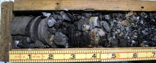


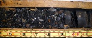


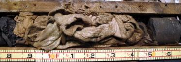
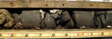
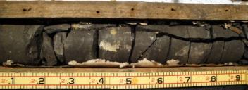


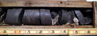

15 Potential source / reservoir rock - coal Cumnock Coal Core Box #1 Note: Top of core cannot be determined. Bottom Cumnock Coal Core Box #2 Top Bottom Cumnock Coal Core Box #3 Top Cumnock Coal Core Box #4 Note: Top of Core cannot be determined. Coal Cores from the Cumnock Mine (previously known as Egypt Mine), donated by Mr. J. Daniel Butler February 12, 2010


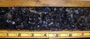
16 Potential source/reservoir rock

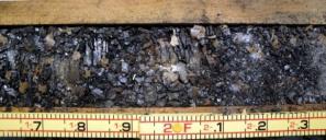
17 Potential reservoir rocks


18 Mostly quartz+feldspar Clays are subequal chlorite + illite; very minor kaolinite + mixed I/S Some calcite veins observed 18
19 TOC data distribution Distribution of TOC data, Sanford sub-basin, Deep River Basin (Reid and Milici, USGS OFR ) ** TOC Sanford sub-basin = 1.96; N = 353 as of August 2012 Distribution of TOC data, Dan River-Danville Basin (Reid and Milici, USGS OFR )

20 Kerogen type and maturity (Tmax) multiple wells: Sanford sub-basin Simpson #1 LE-OT-1-98 Dummitt Palmer #1 - LE-OT-82 Bobby Hall #1 LE-OT-2-83 LE-C-4-45 BDH-9 USBM2 **%Ro = 1.25%, N = 42 as of August 2012

21 0.2% onset of digenesis %Ro All data, Sanford sub-basin Estimated maximum erosion is ~3,000 ft Observed variations are: V.R. Groce #1: -1,800 ft Butler #3: -1,000 ft Simpson #1: -3,000 ft (maximum observed) Dummitt-Palmer #1 (CBM) near dikes and overcooked (updip, basin edge) Bobby Hall #1 After Dow, 1977 (method)


22 Dan River-Danville Basin Glimpse From Reid, Taylor and Simons,


23 Stratigraphy Proposed revision From Olsen, Reid, Kent and Whiteside, 2012 manuscript in preparation 23


24 Dan River-Danville Basin Structure From Olsen, Reid, Kent and Whiteside, 2012 manuscript in preparation View to northeast 24
.")
25 Synthetic gamma-ray study R1_cps R2_cps Synthetic gamma-ray study Eden Mbr. - low count rate. ~1,500 feet true thickness, dips 30 o NW (to right of image). Potential source / reservoir rock. 25


26 Eden Mbr. potential source rock/reservoir N W NW 26
27 Mostly quartz+feldspar Eden Mbr. (red squares) Walnut Cove Mbr. (black triangles) 27

28 Dan River-Danville Basin: 2012 %Ro and TOC results split by Cow Branch member Ro% = 2.077, n = 25 %Ro = 1.850, n = 23 TOC = 1.384%, n= 42 TOC = 3.553%, n = 122
29 U, Th content of the shales Basin Geologic unit U ppm (mean, ICP-MS) U ppm (mean, INAA) Th ppm (mean by ICP- MS) Th ppm (mean by INAA) Sanford subbasin Dan River Danville Basin Detection limit Cumnock Fm N = 76 Cow Branch - Eden Mbr. Cow Branch - Walnut Cove Mbr N = N = N = N = N = N = N = ppm 0.5 ppm 0.1 ppm 0.2 ppm Black shale average from AGI Data Sheets, 1982: U = 3.7 ppm; Th = 12 ppm 29
30 Public participation Oct. 10, 2011 Public meeting in Sanford sub-basin Draft plan of study was presented; the STRONGER process was discussed. Public comment was received as to how the study should be conducted. Comment was received and written comment on the draft outline of the study were accepted through Oct. 18, March 20 and 27, 2012 Additional public meetings in Sanford sub-basin, Draft findings and recommendations were presented in a public meetings. Meetings were streamed live online, the same information was presented, and public comments were accepted at both meetings, via mail and . April 2, Last day to agency received written comments on the draft report. April 3, Chatham Co. hosted a third meeting; public comments were received. STRONGER (State Review of Oil & Natural Gas Environmental Regulations) Reviewed N. C. s oil & gas regulatory programs in October 2011 at the agency s request. STRONGER report issued in February DENR study released: URL Extensive legislative debate spring and summer
31 S820 Highlights Begins process to create regulations & standards via a Mining and Energy Commission. Three study reports due October 1, 2013 Impact on local government and infrastructure (includes fee structure), Local government authority in regulation, and Forced pooling. State legislature will vote 2 years hence to approve final rules to allow permit applications. Rule-making deadline is October Any contamination is assumed to be from drilling unless proven otherwise. Provides for groundwater supply remedy. Mineral rights owner: to be paid 12.5% minimum royalties; deduction of operating expenses not allowed; and 7 day period to back out of lease. 31
32 Conclusions North Carolina Mesozoic basins contain continuous gas deposits (Deep River Basin, Dan River-Danville Basin). With new completion technology, these deposits may become economically recoverable. Horizontal drilling and hydraulic fracturing are now legal in North Carolina. A process is in place to establish rules and regulation could allow permits as early as 2014 following final legislative approval. 32

33 Jim Jeff Kenneth Contact information Dr. Jeffrey C. Reid, PG, CPG, Senior Geologist North Carolina Geological Survey, Telephone

34 East Coast Mesozoic Basins not numerically assessed Source: USGS Fact Sheet


35 Examples of input EUR data for shale gas and tight gas assessment units (USGS OFR )

36 USGS Open-File Report

37 USGS Open-File Report

38 38
39 SB What hath the legislature wrought? Controversial bill; passed by one vote overriding the Governor s veto. 39
40 Dan River-Danville Basin glimpse (Reid and Milici, USGS OFR ) 40


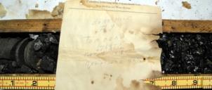
41 Drill Hole : USBM DH-2 NCGS No.: CH-C-1-45 Box No. : 118 From : 1423 feet to 1440 feet Drill Hole :USBM DH-2 NCGS No.: CH-C-1-45 Box No. : 119 From : 1440 feet to 1449 feet
42 Our 25-year journey Jan organic data collection started (Reid). Dec manuscript completed; on hold other work assignments (Reid) Simpson #1 and Butler #3 wells drilled. Jun USGG OFR (Reid and Milici) released. Aug DENR issues Strategic Plan tasked the N.C. Geological Survey to continue evaluation and exploration of natural gas in the State. Spring 2010 leasing starts; ~10,000 acres in the Sanford sub-basin and flurry of inquiries Many( 65) presentations to state, local and professional meetings; legislation mulled to update the out-dated 1945 Oil and Gas Act NC General Assembly study bill Session Law (H.B. 242) to determine the oil and gas resources present in the Triassic basins and in any other areas of the State. July USGS geologic assessment meeting Denver (Reid and Simons) DENR study and public comment STRONGER review of state regulations USGS Assessment released, Fact Sheet General Assembly enacts energy bill (S820); Overrides Governor s veto; legalizes hydraulic fracturing and horizontal drilling Mining Commission expanded to Mining and Energy Commission, Members appointed. 42

43 43
44 Public participation Three public hearings were held in the Triassic Basin. The first was on Oct. 10, 2011, and the draft plan of study was presented; the STRONGER process was discussed; and public comment was received as to how the study should be conducted. Comment was received and written comment on the draft outline of the study were accepted through Oct. 18, Two additional public meetings occurred in March 2012 to discuss the draft report. Draft findings and recommendations were presented in a public meetings on March 20, 2012 and on March 27, Both meetings were streamed live online, the same information was presented, and public comments were accepted at both meetings, via mail and . Chatham County hosted a third meeting on April 2 where public comments were received. Written comments on the draft report were accepted through April 2, plus feedback received at the two public meetings. DENR requested a nonprofit organization called State Review of Oil & Natural Gas Environmental Regulations (STRONGER) to review of North Carolina s oil and gas regulatory programs. The STRONGER review process brought together representatives from the state, the oil and gas industry, and public interest stakeholders to evaluate the state s regulatory programs against STRONGER s set of national guidelines. STRONGER s review panel met in late October to gather information about the state s processes, and issued a report in late February DENR study located at URL 44
45 STRONGER Review DENR requested a nonprofit organization called State Review of Oil & Natural Gas Environmental Regulations (STRONGER) to review of North Carolina s oil and gas regulatory programs. The STRONGER review process brought together representatives from the state, the oil and gas industry, and public interest stakeholders to evaluate the state s regulatory programs against STRONGER s set of national guidelines. STRONGER s review panel met in October 2011 to gather information about the state s processes, and issued a report in February

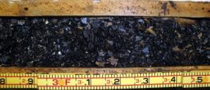
46 Potential reservoir rocks
47 S820 Highlights cont d Boldface disclosure that property owners leasing land secure written approval from their mortgage lenders. Groundwater testing: Energy companies required to test groundwater in a 5,000-feet radius of a drill site before and after drilling. Any contamination is assumed to be from drilling unless proven otherwise. Provides for groundwater supply remedy. 47
MESOZOIC BASINS. North Carolina Geological Survey
 MESOZOIC BASINS North Carolina Geological Survey The 1823 organic act which created the North Carolina Geological Survey (NCGS) tasked us to examine, describe and map the geology, geologic hazards, and
Dr. Kenneth B. Taylor, P.G.
 North Carolina Forestry Association 2013 Annual Meeting October 3, 2013 Shale Gas 101: Natural Gas Exploration / Development: A North Carolina Perspective presented by Dr. Kenneth B. Taylor, P.G. State
Overview of Selected Shale Plays in New Mexico*
 Overview of Selected Shale Plays in New Mexico* Ron Broadhead 1 Search and Discovery Article #10627 (2014)** Posted August 18, 2014 *Adapted from presentation at RMAG luncheon meeting, Denver, Colorado,
Unconventional Reservoir Development: The Role of Geoscience from a State Regulator s Perspective
 Unconventional Reservoir Development: The Role of Geoscience from a State Regulator s Perspective Nick Tew Alabama State Geologist and Oil and Gas Supervisor President, American Geosciences Institute Geological
USGS/Duke University Baseline Groundwater Quality Sampling in parts of Lee and Chatham Coun?es, North Carolina
 Lee County Public Health USGS/Duke University Baseline Groundwater Quality Sampling in parts of Lee and Chatham Coun?es, North Carolina Melinda Chapman U.S. Geological Survey, Groundwater Specialist North
OVERVIEW OF THE ROGERSVILLE SHALE IN WEST VIRGINIA. Philip Dinterman West Virginia Geological & Economic Survey May 11, 2017
 OVERVIEW OF THE ROGERSVILLE SHALE IN WEST VIRGINIA Philip Dinterman West Virginia Geological & Economic Survey May 11, 2017 ACKNOWLEDGEMENT Dave Harris, John Hickman, Kentucky Geological Survey DATA NOTE
Pros and Cons against Reasonable Development of Unconventional Energy Resources
 Pros and Cons against Reasonable Development of Unconventional Energy Resources Associate Professor Shteryo LYOMOV, Ph.D. Presentation outline Energy resources; Conventional and Unconventional energy resources;
NORTH AMERICAN ANALOGUES AND STRATEGIES FOR SUCCESS IN DEVELOPING SHALE GAS PLAYS IN EUROPE Unconventional Gas Shale in Poland: A Look at the Science
 NORTH AMERICAN ANALOGUES AND STRATEGIES FOR SUCCESS IN DEVELOPING SHALE GAS PLAYS IN EUROPE Unconventional Gas Shale in Poland: A Look at the Science Presented by Adam Collamore Co-authors: Martha Guidry,
Natural Gas Assessment of the Arkoma Basin, Ouachita Thrust Belt, and Reelfoot Rift Introduction & Methodology Overview
 Natural Gas Assessment of the Arkoma Basin, Ouachita Thrust Belt, and Reelfoot Rift Introduction & Methodology Overview Upper Atoka incised channel deposit at Ozark, Arkansas Dave Houseknecht U.S. Department
2016 U.S. Geological Survey Assessment of Continuous Oil and Gas Resources in the Mancos Shale of the Piceance Basin
 2016 U.S. Geological Survey Assessment of Continuous Oil and Gas Resources in the Mancos Shale of the Piceance Basin U.S. Department of the Interior U.S. Geological Survey Uinta-Piceance Province Colorado
Stephanie B. Gaswirth and Kristen R. Mara
 U.S. Geological Survey Assessment of Undiscovered Resources in the Bakken and Three Forks Formations, Williston Basin, North Dakota, Montana, and South Dakota, 2013 Stephanie B. Gaswirth and Kristen R.
Atlantic Rim Coalbed Methane Play: The Newest SuccessfulCBM Play in the Rockies
 Atlantic Rim Coalbed Methane Play: The Newest SuccessfulCBM Play in the Rockies Robert A. Lamarre Lamarre Geological, Denver, Colorado Stephen K. Ruhl Anadarko Petroleum Corporation, The Woodlands, Texas
BEFORE THE CORPORATION COMMISSION OF THE STATE OF OKLAHOMA OPERATING LLC LOCATION EXCEPTION. Report of the Administrative Law Judge
 n APPLICANT: BEFORE THE CORPORATION COMMISSION OF THE STATE OF OKLAHOMA RELIEF SOUGHT BILLY JACK SHARBER OPERATING LLC LOCATION EXCEPTION LEGAL DESCRIPTION NW/4 SE/4 OF SECTION 29, TOWNSHIP NORTH, RANGE
Cuyama Basin North Fork Vineyard
 Cuyama Basin North Fork Vineyard Company Background plus Data Insights to Support GSP Development for the Cuyama Basin Presented by Grapevine Capital Partners and Cleath-Harris Geologists April 26th, 2018
EB-2012O-0451, EB , EB : TransCanada Supplemental Evidence pp /17
 TCPL.COC.6 Page 1 of 4 TransCanada PipeLines Limited Response to Council of Canadians Interrogatory #6 Reference: Preamble: Request: EB-2012O-0451, EB-2012-0433, EB-2013-0074: TransCanada Supplemental
MUHAMMAD S TAMANNAI, DOUGLAS WINSTONE, IAN DEIGHTON & PETER CONN, TGS Nopec Geological Products and Services, London, United Kingdom
 Geological and Geophysical Evaluation of Offshore Morondava Frontier Basin based on Satellite Gravity, Well and regional 2D Seismic Data Interpretation MUHAMMAD S TAMANNAI, DOUGLAS WINSTONE, IAN DEIGHTON
Update on Prospectivity Studies of the Georgina and Cooper Basins
 Update on Prospectivity Studies of the Georgina and Cooper Basins Dianne Edwards, Lisa Hall, Bridget Ayling and the Onshore Energy Systems Group, Resources Division Northern Territory, Queensland and South
=%REPORT RECONNAISSANCE OF CHISHOLM LAKE PROSPECT. October 25, 1977
 =%REPORT ON FIELD RECONNAISSANCE OF CHISHOLM LAKE PROSPECT October 25, 1977 Bruce D. Vincent Imperial Oil Limited, Minerals - Coal, CALGARY, ALBERTA CHISHOLM LAKE PROSPECT Introduction The Chisholm Lake
Petroleum Systems (Part One) Source, Generation, and Migration
 Source, Generation, and Migration") Petroleum Systems (Part One) Source, Generation, and Migration GEOL 4233 Class January 2008 Petroleum Systems Elements Source Rock Migration Route Reservoir Rock Seal Rock Trap Processes Generation Migration
Petroleum Systems (Part One) Source, Generation, and Migration GEOL 4233 Class January 2008 Petroleum Systems Elements Source Rock Migration Route Reservoir Rock Seal Rock Trap Processes Generation Migration
Section 2 Oil and Gas Exploration and Extraction
 Section 2 Oil and Gas Exploration and Extraction A. How hydrocarbons are generated and trapped in the Earth Hydrocarbons 101 Hydrocarbons are naturally occurring organic compounds composed of hydrogen
Depositional History and Petroleum Potential of Ombilin Basin, West Sumatra - Indonesia, Based on Surface Geological Data*
 Depositional History and Petroleum Potential of Ombilin Basin, West Sumatra - Indonesia, Based on Surface Geological Data* Yahdi Zaim 1, Litto Habrianta 2, Chalid I. Abdullah 1, Aswan 1, Yan Rizal 1, Nurcahyo
Lecture Outline Wednesday - Friday February 14-16, 2018
 Lecture Outline Wednesday - Friday February 14-16, 2018 Quiz 2 scheduled for Friday Feb 23 (Interlude B, Chapters 6,7) Questions? Chapter 6 Pages of the Past: Sedimentary Rocks Key Points for today Be
Running Head: Fracking Analysis in North Carolina 1 COST BENEFIT ANALYSIS OF FRACKING IN NORTH CAROLINA. Matthew B. Aupperle
 Running Head: Fracking Analysis in North Carolina 1 COST BENEFIT ANALYSIS OF FRACKING IN NORTH CAROLINA Matthew B. Aupperle Quantitative methods in Rocks and Minerals Steve Teeter Summer Ventures in Science
ISSN Online: X ISSN Print: Shale Gas Potential in Pakistan: By comparison of Sembar formation and Barnett Shale Texas
 Journal of Electrical Power & Energy Systems, 2018, 2(9), 19-25 http://www.hillpublisher.com/journals/jepes/ ISSN Online: 2576-053X ISSN Print: 2576-0521 Shale Gas Potential in Pakistan: By comparison
Lab 9: Petroleum and groundwater
 Geology 101 Name(s): Lab 9: Petroleum and groundwater Petroleum (oil) is a multi-component liquid refined to generate different hydrocarbons, such as heptane (a component of gasoline) and waxes. For the
UPDATE ON HYDROCARBON LAW AND PROJECTIONS OF SHALE GAS RESOURCES
 UPDATE ON HYDROCARBON LAW AND PROJECTIONS OF SHALE GAS RESOURCES Marta Wagrodzka Department of Geology and Geological Concessions April 24 th, 2013 American-Polish Energy Roundtable Primary energy demand
Petroleum Potential of the Application Area L12-4
 Petroleum Potential of the Application Area L12-4 The Application Area (L12-4) is underlain by the western Officer Basin, beneath the Gunbarrel Basin. The general basin architecture is outlined in Figure
Shasta Valley Groundwater Basin Boundary Modification
 Shasta Valley Groundwater Basin Boundary Modification Sustainable Groundwater Management Act (SGMA) September 2014 Governor Brown signs legislation requiring groundwater resources be managed by local agencies
Potential for Shale Gas in Georgia:
 Potential for Shale Gas in Georgia: Preliminary Study for Feasibility Analysis of Shale Gas Exploration in Georgia Prepared for: AEAI under Grant Agreement #ECI GA R2 48 Georgia Energy Capacity Initiative
The Shale Spectrum: Interdisciplinary understanding across oil shale, oil-bearing shale and gas shale plays
 The Center for Oil Shale Technology & Research & The Colorado School of Mines 31sᵗOil Shale Symposium October 17-21, 2011 at the Cecil H. & Ida Green Center, Colorado School of Mines, Golden, Colorado
Emily-1 First Exploration Well in PEL-182
 ACN 051 212 429 First Floor, 14 Outram Street, West Perth WA 6005 Telephone: +61 8 9481 3322 PO Box 913 West Perth WA 6872 Facsimile: +61 8 9481 3330 Emily-1 First Exploration Well in PEL-182 Drilling
EXPLORATION NEWS RELEASE MAGISTRAL DISTRICT: MORE GROWTH, MORE GOLD, MORE SILVER
 EXPLORATION NEWS RELEASE MAGISTRAL DISTRICT: MORE GROWTH, MORE GOLD, MORE SILVER.1 OPT GOLD OVER 6 FT. 5.6 OPT SILVER EQUIVALENT OVER 65 FT. INCLUDING 13.6 OPT SILVER EQUILALENT OVER 15 FT. Denver, Colorado
Presentation to the NATIONAL BUYER / SELLER FORUM March 24, Brad J. Hayes Petrel Robertson Consulting Ltd.
 Presentation to the NATIONAL BUYER / SELLER FORUM March 24, 2010 Brad J. Hayes Petrel Robertson Consulting Ltd. Canada s Gas Resources the Picture in 2010 This gas resource picture is only a snapshot because
Sequence Stratigraphy of the Upper Cretaceous Niobrara Formation, A Bench, Wattenberg Field, Denver Julesburg Basin, Colorado*
 Sequence Stratigraphy of the Upper Cretaceous Niobrara Formation, A Bench, Wattenberg Field, Denver Julesburg Basin, Colorado* Lisa E. Remington LaChance 1 and Mark C. Robinson 1 Search and Discovery Article
Challenge of Mae Sot Oil Shale Exploration in Thailand (In the First Phase, 2008) Apichart Jeennagol Apiradee Suwannathong
 Apichart Jeennagol Apiradee Suwannathong") Challenge of Mae Sot Oil Shale Exploration in Thailand (In the First Phase, 2008) by Apichart Jeennagol Apiradee Suwannathong The 28 th Oil Shale Symposium October 15, 2008 Colorado School of Mines, Golden,
Challenge of Mae Sot Oil Shale Exploration in Thailand (In the First Phase, 2008) by Apichart Jeennagol Apiradee Suwannathong The 28 th Oil Shale Symposium October 15, 2008 Colorado School of Mines, Golden,
Detailed Gravity and Magnetic Survey of the Taylorsville Triassic Basin
 Detailed Gravity and Magnetic Survey of the Taylorsville Triassic Basin Technical Progress Report Report Period 6/2/97 to 12/31/97 Dr. John Leftwich, Project Director Dr. Ali A. Nowroozi, Co-Principal
Sediment and sedimentary rocks Sediment
 Sediment and sedimentary rocks Sediment From sediments to sedimentary rocks (transportation, deposition, preservation and lithification) Types of sedimentary rocks (clastic, chemical and organic) Sedimentary
PETE/GEOS 445/645 Petroleum Geology 3 credits
 PETE/GEOS 445/645 Petroleum Geology 3 credits Tuesday, Thursday 3:40-5:10 Reichardt 233 Hydrocarbons fuel today s economy, but remain a relatively rare natural resource. The objective of this course is
Trapping Mechanisms along North Similan and Lanta Trends, Pattani Basin, Gulf of Thailand
 Trapping Mechanisms along North Similan and Lanta Trends, Pattani Basin, Gulf of Thailand Piyaporn Aukkanit Petroleum Geoscience Program, Department of Geology, Faculty of Science, Chulalongkorn University,
Review of April 2016 Lawrence County Seismic Events
 Review of April 2016 Lawrence County Seismic Events February 17, 2017 Dial-in number for Audio: 1-650-479-3208 Event Number: 640 637 941 WebEx Technical Support: 866-229-3239 Note: You will not hear any
Engaging a Tribal College in the Assessment of Oil and Gas Resources on a Sioux Indian Reservation
 1 Nov 2015 New Horizons O&G Conference field trip, Black Hills, SD, 2014 Engaging a Tribal College in the Assessment of Oil and Gas Resources on a Sioux Indian Reservation Geological Society of America
Results of Preliminary Study of Shale Gas and Shale Oil Perspectives in Georgia
 World Experience in Shale Oil & Gas Industry and prospects of its Development in Georgia Results of Preliminary Study of Shale Gas and Shale Oil Perspectives in Georgia By: Archil Magalashvili Murman Margvelashvili
Potentials for Mineral and Hydrocarbon Development in the Northern part of Greenland
 Potentials for Mineral and Hydrocarbon Development in the Northern part of Greenland WWF Seminar Iqaluit, 4-5 June 2013 Maja Sofie Burgaard Bureau of Minerals and Petroleum Agenda The Greenland Government
DENR s Oil and Gas Initiative. Legislative briefing March 7, 2011 by DENR s Geological Survey Program
 DENR s Oil and Gas Initiative Legislative briefing March 7, 2011 by DENR s Geological Survey Program South Dakota DOES have exploration for and production of oil and gas Taken from http://denr.sd.gov/des/og/producti.aspx
Kilometre-Scale Uplift of the Early Cretaceous Rift Section, Camamu Basin, Offshore North-East Brazil*
 Kilometre-Scale Uplift of the Early Cretaceous Rift Section, Camamu Basin, Offshore North-East Brazil* Iain Scotchman 1 and Dario Chiossi 2 Search and Discovery Article #50183 (2009) Posted May 20, 2009
EVALUATION OF KEY FACTORS AFFECTING SUCCESSFUL OIL PRODUCTION IN THE BAKKEN FORMATION, NORTH DAKOTA. Technology Status Assessment.
 EVALUATION OF KEY FACTORS AFFECTING SUCCESSFUL OIL PRODUCTION IN THE BAKKEN FORMATION, NORTH DAKOTA Technology Status Assessment Prepared by: James A. Sorensen Senior Research Manager Energy & Environmental
URANIUM RESOURCES IN NEW MEXICO. Virginia T. McLemore New Mexico Bureau of Geology and Mineral Resources, New Mexico Tech, Socorro, NM
 URANIUM RESOURCES IN NEW MEXICO Virginia T. McLemore New Mexico Bureau of Geology and Mineral Resources, New Mexico Tech, Socorro, NM Purpose Describe the uranium industry in New Mexico, with emphasis
NOA ASSESSMENT HARRIS QUARRY MENDOCINO COUNTY, CALIFORNIA TABLE OF CONTENTS
 NOA ASSESSMENT HARRIS QUARRY MENDOCINO COUNTY, CALIFORNIA TABLE OF CONTENTS Introduction... 1 Scope of Services... 1 Project Location and Description... 1 Geologic Setting... 1 Regional Geology... 1 Site
Drilling & Developing the Marcellus Shale
 Drilling & Developing the Marcellus Shale Presented by the Independent Oil and Gas Association of Pennsylvania at the Pennsylvania State Association of Township Supervisors Annual Meeting, May 12, 2008,
Applications of Borehole Imaging to Hydrocarbon Exploration and Production
 Applications of Borehole Imaging to Hydrocarbon Exploration and Production Instructor: Philippe MONTAGGION / NExT, Schlumberger Title: Petroleum Geology Consultant Specialty: Borehole Imaging, Petroleum
North Dakota Geological Survey
 Review of Hydrocarbon Production from the Stonewall and lower Interlake Formations: western North Dakota Williston Basin Timothy O. Nesheim North Dakota Geological Survey North Dakota Geological Survey
A Case Study into the Successful Evaluation and Completion Nonconventional. Jorge Viamontes, PhD VP Reservoir Intelligence, NUTECH
 A Case Study into the Successful Evaluation and Completion Nonconventional Wells in Mexico Jorge Viamontes, PhD VP Reservoir Intelligence, Presentation Outline - experience in the Eagle Ford and Burgos
Maturity Modeling of Gomin and South Gomin fields Southern Pattani Basin, Gulf of Thailand
 Maturity Modeling of Gomin and South Gomin fields Southern Pattani Basin, Gulf of Thailand Patinya Jaithan Petroleum Geoscience Program, Department of Geology, Faculty of Science, Chulalongkorn University,
Unconventional Natural Gas A Brief Review for Instituto Petroquimica Argentina
 October 5, 2010 Unconventional Natural Gas A Brief Review for Instituto Petroquimica Argentina William L. Tittle Principal and Director of Strategy Americas and Asia Raul Arias Alvarez Senior Consultant
Exploration, Drilling & Production
 Nontechnical Guide to PETMOLEUM Geology, Exploration, Drilling & Production Third Edition Norman J. Hyne, Ph.D. Contents Preface *i Introduction 1 The Nature of Gas and Oil 1 Petroleum 1 The Chemistry
NEWS RELEASE FOR IMMEDIATE RELEASE: MARCH 5, 2018
 NEWS RELEASE FOR IMMEDIATE RELEASE: MARCH 5, 2018 Eskay Mining provides update on ongoing geological review - Targeting E&L-Type Nickel-Copper-PGE and Eskay-Type VMS Potential on Its Golden Triangle Holdings:
IN SOUTH DAKOTA PAST, PRESENT, AND FUTURE. GERALD (MACK) McGILLIVRAY OCTOBER 8-9, 2008
 McGILLIVRAY OCTOBER 8-9, 2008") SHALLOW GAS EXPLORATION & PRODUCTION IN SOUTH DAKOTA PAST, PRESENT, AND FUTURE BY GERALD (MACK) McGILLIVRAY 2009 ROCKY MOUNTAIN UNCONVENTIONAL GAS CONFERENCE OCTOBER 8-9, 2008 HISTORY OF SHALLOW GAS IN
SHALLOW GAS EXPLORATION & PRODUCTION IN SOUTH DAKOTA PAST, PRESENT, AND FUTURE BY GERALD (MACK) McGILLIVRAY 2009 ROCKY MOUNTAIN UNCONVENTIONAL GAS CONFERENCE OCTOBER 8-9, 2008 HISTORY OF SHALLOW GAS IN
Geomechanical controls on fault and fracture distribution with application to structural permeability and hydraulic stimulation
 CSPG Luncheon Calgary February 5 th 2015 Geomechanical controls on fault and fracture distribution with application to structural permeability and hydraulic stimulation Scott Mildren - Ikon Science Australian
U.S. Shale Gas. From Resources and Reserves to Carbon Isotope Anomalies. John B. Curtis Potential Gas Agency Colorado School of Mines
 U.S. Shale Gas From Resources and Reserves to Carbon Isotope Anomalies John B. Curtis Potential Gas Agency Colorado School of Mines Major U.S. Basins and Shale Plays c. 2007 (Where are the Haynesville
by Bogdan Popescu Zeta Petroleum (Romania) and Serban Veliciu - Center for Green Energy Information (Geneva)
 and Serban Veliciu - Center for Green Energy Information (Geneva)") ROMANIA s GAS SHALE RESOURCES and ENERGY SECURITY in WEST BLACK SEA AREA by Bogdan Popescu Zeta Petroleum (Romania) and Serban Veliciu - Center for Green Energy Information (Geneva) In the early 2000 there
ROMANIA s GAS SHALE RESOURCES and ENERGY SECURITY in WEST BLACK SEA AREA by Bogdan Popescu Zeta Petroleum (Romania) and Serban Veliciu - Center for Green Energy Information (Geneva) In the early 2000 there
Kansas Underground Injection Control Program & Induced Seismicity. By: Benjamin Busboom Stinson Leonard Street
 Kansas Underground Injection Control Program & Induced Seismicity By: Benjamin Busboom Stinson Leonard Street What is underground injection? Unground injection is used to place fluid underground into porous
GEOLOGY, RESOURCES, AND POTENTIAL ACTIVITY LEVELS
 GEOLOGY, RESOURCES, AND POTENTIAL ACTIVITY LEVELS NAS Workshop on the Development of Unconventional Hydrocarbon Resources in the Appalachian Basin Ray Boswell, US DOE/NETL Morgantown, West Virginia September
MONETA INTERCEPTS g/t GOLD INCLUDING g/t GOLD AT SOUTH WEST
 NEWS RELEASE 13/2018 Symbol: TSX: ME FOR IMMEDIATE RELEASE MONETA INTERCEPTS 25.00 m @ 2.48 g/t GOLD INCLUDING 4.50 m @ 5.00 g/t GOLD AT SOUTH WEST Toronto, Ontario September 13, 2018 - Moneta Porcupine
Outline 16: The Mesozoic World: Formation of Oil Deposits (with a side trip to the Devonian Marcellus Shale)
") Outline 16: The Mesozoic World: Formation of Oil Deposits (with a side trip to the Devonian Marcellus Shale) The first commercial oil well was drilled by Colonel Edwin Drake in Titusville, Pennsylvania,
Outline 16: The Mesozoic World: Formation of Oil Deposits (with a side trip to the Devonian Marcellus Shale) The first commercial oil well was drilled by Colonel Edwin Drake in Titusville, Pennsylvania,
Krasny license: Operational update February 2016
 Kopy Goldfields AB (publ) Press release 3/2016 Stockholm, March 2, 2016 Krasny license: Operational update February 2016 Kopy Goldfields AB (publ) ( Kopy Goldfields or the Company ) hereby provides an
Pseudo-Source Rock Characterization
 IOSR Journal of Applied Chemistry (IOSR-JAC) e-issn: 2278-5736.Volume 8, Issue 1 Ver. I. (Jan. 2015), PP 46-50 www.iosrjournals.org Pseudo-Source Rock Characterization 1 Swapan Kumar Bhattacharya, 2 Juwita
Tim Carr - West Virginia University
 Tim Carr - West Virginia University Exploration s Ultimate Goal is to Answer Four Questions: Where to Drill? What to Expect? How Certain? How Profitable? Location & Depth HC Volumes Chance of Success
Cove Gold Project 2201 Discovery Update, May 2014
 Proven Management Proven Gold Districts Safe Jurisdictions Cove Gold Project 2201 Discovery Update, May 2014 Symbol: Exchange: PG TSX 1-888-346-1390 DISCLAIMER: This presentation may contain "forward looking
BEFORE THE CORPORATION COMMISSION OF THE STATE OF OKLAHOMA LEGAL DESCRIPTION: SE/4 OF SECTION 31, TOWNSHIP 20
 BEFORE THE CORPORATION COMMISSION OF THE STATE OF OKLAHOMA APPLICANT: CROWN ENERGY COMPANY ) RELIEF SOUGHT: HORIZONTAL DRILLING AND ) CAUSE CD NO. SPACING UNIT ) 201102915 ) LEGAL DESCRIPTION: SE/4 OF
Exploration / Appraisal of Shales. Petrophysics Technical Manager Unconventional Resources
 Exploration / Appraisal of Shales Rick Lewis Petrophysics Technical Manager Unconventional Resources Organic Shale Factors Controlling Gas Reservoir Quality Conventional sandstone Mineral framework Gas
Overview of Woodford Gas-Shale Play in Oklahoma, 2008 Update
 Oklahoma Gas Shales Conference October 22, 2008 Overview of Woodford Gas-Shale Play in Oklahoma, 2008 Update Brian J. Cardott Oklahoma Geological Survey Number of Wells 300 250 200 Oklahoma Shale-Gas Well
For personal use only
 12 October 2012 Companies Announcement Office Australian Securities Exchange Limited 10th Floor, 20 Bond Street SYDNEY NSW 2000 ADVENT ENERGY LTD SHALE GAS DATA RELEASE MEC Resources Limited (ASX:MMR)
23 January, 2018 CSE: RFR For Immediate Release. Renforth extends Parbec Gold Deposit strike 60m with gold in all 7 drillholes
 Suite 200 65 Front St. East Toronto, ON M5E 1B5 www.renforthresources.com 23 January, 2018 CSE: RFR For Immediate Release Renforth extends Parbec Gold Deposit strike 60m with gold in all 7 drillholes Renforth
Geology of the Louisiana Haynesville Shale Play
 Annual Institute on Mineral Law Volume 56 The 56th Annual Institute on Mineral Law Article 6 4-2-2009 Geology of the Louisiana Haynesville Shale Play Louis Gilbert Follow this and additional works at:
Hydraulic Impacts of Limestone Quarries and Gravel Pits. Jeff Green Minnesota DNR-Division of Ecological & Water Resources
 Hydraulic Impacts of Limestone Quarries and Gravel Pits Jeff Green Minnesota DNR-Division of Ecological & Water Resources The Hydraulic Impacts of Limestone Quarries and Gravel Pits Study was funded by
DEP Office of Oil and Gas Management
 DEP Office of Oil and Gas Management Bureau of Oil and Gas Planning and Program Management Well Plugging and Subsurface Activities Division Production Waste Trends and Management May 19, 2017 2017 Shale
Licensed Science Officer Benchmark
 POSITION EVALUATION RATIONALE POSITION TITLE Senior Project Geologist MINISTRY AND DIVISION Energy, Mines and Petroleum Resources: Geological Division BRANCH AND SECTION Mineral Resources UNIT OR PROGRAM
EAS 233 Geologic Structures and Maps Winter Miscellaneous practice map exercises. 1. Fault and separation:
 Miscellaneous practice map exercises 1. Fault and separation: With respect to Map 1, what are (a) the orientation of the fault, and (b) the orientation of bedding in the units cut by the fault. (c) Mark
Relinquishment Report
 Relinquishment Report Licence P.089 Block 22/15a 2 nd Round Traditional Licence Award (Operator): 100.0% Disclaimer No representation or warranty, express or implied, is or will be made in relation to
The map The ma (Somaliland ( Somaliland Somalia) SOMALIA SOMALILAND
 SOMALIA SOMALILAND") SOMALILAND COUNTRY BACKGROUND & HYDROCARBON POTENTIAL MINISTRY OF WATER & MINERAL RESOURCES PRESENTATION OUTLINE Introduction Petroleum Geology Petroleum Regulations & PSC Model Re-sizing of Blocks Current
SOMALILAND COUNTRY BACKGROUND & HYDROCARBON POTENTIAL MINISTRY OF WATER & MINERAL RESOURCES PRESENTATION OUTLINE Introduction Petroleum Geology Petroleum Regulations & PSC Model Re-sizing of Blocks Current
Content. Conventional and Continuous Resources Concepts and Examples. Threshold geological parameters for source-rock resource potential
 Content Conventional and Continuous Resources Concepts and Examples Threshold geological parameters for source-rock resource potential Heterogeneity of source-rock systems USGS oil and gas assessments
Licensed Science Officer Benchmark
 POSITION EVALUATION RATIONALE POSITION TITLE MINISTRY AND DIVISION Energy, Mines and Petroleum Resources: Geology Division BRANCH AND SECTION Mineral Resources Branch, Applied Geology Section UNIT OR PROGRAM
Case Study of the Structural and Depositional-Evolution Interpretation from Seismic Data*
 Case Study of the Structural and Depositional-Evolution Interpretation from Seismic Data* Yun Ling 1, Xiangyu Guo 1, Jixiang Lin 1, and Desheng Sun 1 Search and Discovery Article #20143 (2012) Posted April
Geology 12 FINAL EXAM PREP. Possible Written Response Exam Questions
 Geology 12 FINAL EXAM PREP Possible Written Response Exam Questions Use this study guide to prepare for the written response portion of the final exam. Name FINAL EXAM - POSSIBLE WRITTEN RESPONSE QUESTIONS
EXAMINER S REPORT AND RECOMMENDATION STATEMENT OF THE CASE
 OIL AND GAS DOCKET NO. 08-0248239 THE APPLICATION OF PETRO-HUNT, L.L.C. TO CONSIDER NEW FIELD DESIGNATION AND FIELD RULES FOR THE (PROPOSED) TOYAH, NW (SHALE) FIELD, REEVES COUNTY, TEXAS Heard by: Donna
Virginia T. McLemore, New Mexico Bureau of Geology and Mineral Resources, New Mexico Institute of Mining and Technology, Socorro, NM 87801,
 Virginia T. McLemore, New Mexico Bureau of Geology and Mineral Resources, New Mexico Institute of Mining and Technology, Socorro, NM 87801, ginger@gis.nmt.edu U2011, Casper, Wy September 20, 2011 Acknowledgments
Key Elements of the Petroleum Systems of the Rockall and Slyne-Erris Basins
 Key Elements of the Petroleum Systems of the Rockall and Slyne-Erris Basins Bandon Corrib Dooish Atlantic Ireland Conference, Dublin, 1 st - 2 nd November 2016 Rockall and Slyne-Erris Basins Only 11 exploration
- 2 - TABLE 1. INDICATED AND INFERRED GOLD AND SILVER RESOURCES. All Indicated
 November 30, 2012 TECHNICAL REPORT TO BE RELEASED THAT PRESENTS FIRST MINERAL RESOURCE ESTIMATE TO NI 43-101 STANDARDS FOR CAHUILLA PROJECT IN IMPERIAL COUNTY, CALIFORNIA BY TERAS RESOURCES. POSITIVE GOLD-SILVER
Controls on clastic systems in the Angoche basin, Mozambique: tectonics, contourites and petroleum systems
 P2-2-13 Controls on clastic systems in the Angoche basin, Mozambique: tectonics, contourites and petroleum systems Eva Hollebeek, Olivia Osicki, Duplo Kornpihl Schlumberger, London, UK Introduction Offshore
Petroleum geology framework, West Coast offshore region
 Petroleum geology framework, West Coast offshore region James W. Haggart* Geological Survey of Canada, Vancouver, BC jhaggart@nrcan.gc.ca James R. Dietrich Geological Survey of Canada, Calgary, AB and
Recap and Integrated Rock Mechanics and Natural Fracture Study on the Bakken Formation, Williston Basin Abstract Figure 1:
 Recap and Integrated Rock Mechanics and Natural Fracture Study on the Bakken Formation, Williston Basin Cosima Theloy, Department of Geology & Geological Engineering Abstract The late Devonian to early
Short Course. Petroleum Geochemistry & Basin Evaluation. Available to EGI Corporate Associate Members. Overview. Objectives.
 Short Course Instructor: David Thul, M.Sc. Manager of Petroleum Geochemistry Petroleum Geochemistry & Basin Evaluation Available to EGI Corporate Associate Members Course Structure Lectures, presentation
The Waitsia Field. Onshore North Perth Basin, Western Australia. APPEA Conference, Brisbane 6 June 2016
 Photograph by Roger Xiang The Waitsia Field Onshore North Perth Basin, Western Australia N. Tupper, E. Matthews, G. Cooper, A. Furniss, T. Hicks and S. Hunt APPEA Conference, Brisbane 6 June 2016 1 Disclaimer
Ministry of Oil and Minerals Petroleum Exploration & Production Authority BLOCK 80 (WADI SARR)
") Ministry of Oil and Minerals Petroleum Exploration & Production Authority BLOCK 80 (WADI SARR) The Wadi Sarr Block (80) occupies an area of 1961 km 2 on the Sayun- Masilah Basin in the central Yemen. Block
Ministry of Oil and Minerals Petroleum Exploration & Production Authority BLOCK 80 (WADI SARR) The Wadi Sarr Block (80) occupies an area of 1961 km 2 on the Sayun- Masilah Basin in the central Yemen. Block
Relinquishment Report Licence P1834
 Valiant Causeway Limited, March 2013 1. Header Licence Number: P1834 Licence Round: 26th Round Licence Type: Traditional Block Number: 204/21, 22b, 23b & 26a Partners: Valiant 100% (Operator) 2. Synopsis
ENGINEER S CERTIFICATION OF FAULT AREA DEMONSTRATION (40 CFR )
") PLATTE RIVER POWER AUTHORITY RAWHIDE ENERGY STATION BOTTOM ASH TRANSFER (BAT) IMPOUNDMENTS LARIMER COUNTY, CO ENGINEER S CERTIFICATION OF FAULT AREA DEMONSTRATION (40 CFR 257.62) FOR COAL COMBUSTION RESIDUALS
PLATTE RIVER POWER AUTHORITY RAWHIDE ENERGY STATION BOTTOM ASH TRANSFER (BAT) IMPOUNDMENTS LARIMER COUNTY, CO ENGINEER S CERTIFICATION OF FAULT AREA DEMONSTRATION (40 CFR 257.62) FOR COAL COMBUSTION RESIDUALS
Hydrocarbon Charge Analysis of the SECC Block, Columbus Basin, Trinidad and Tobago
 Transactions of the 16 th Caribbean Geological Conference, Barbados. Caribbean Journal of Earth Science, 39 (2005), 21-27. Geological Society of Jamaica. Hydrocarbon Charge Analysis of the SECC Block,
TIARO COAL JOINT VENTURE IRWIN RIVER COAL & COAL SEAM GAS QUEENSLAND TCJV AND WEST AUSTRALIAN COAL SEAM GAS PROJECT
 Suite 2, Mezanine Level, 35-37 Havelock Street WestPerth WA 6000 Telephone (08) 9481 8668 Facsimile: (08) 9322 7211 ASX ANNOUNCEMENT/MEDIA RELEASE 30th September 2008 TIARO COAL JOINT VENTURE IRWIN RIVER
Barnett Shale-Woodford Shale play of the Delaware basin is it another giant shale gas field in Texas?
 Barnett Shale-Woodford Shale play of the Delaware basin is it another giant shale gas field in Texas? Bob Cluff The Discovery Group, Inc Denver, Colorado, USA bobcluff@discovery-group.com Delaware basin
Tim Carr - West Virginia University
 GEOGRAPHIC EXTENT OF PETROLEUM SYSTEM A Trap Trap Trap A STRATIGRAPHIC EXTENT OF PETROLEUM SYSTEM Petroleum accumulation Top of oil window Bottom of oil window Overburden Seal Reservoir Source Underburden