A study of the structural geology of an area between the Neusspruit shear zone and the Brakfontein shear zone near Kakamas, Northern Cape.
|
|
|
- Brandon Harrington
- 5 years ago
- Views:
Transcription
1 A study of the structural geology of an area between the Neusspruit shear zone and the Brakfontein shear zone near Kakamas, Northern Cape. A thesis in Structural Geology By TOKOZANI SHUNQUKELA Submitted in partial fulfilment of the requirements for the Degree of Magister Scientiae in the Department of Earth Sciences, University of the Western Cape November 2014 Supervisor Professor Jan van Bever Donker i
2 DECLARATION I declare that A study of the structural geology of an area between the Neusspruit shear zone and the Brakfontein shear zone near Kakamas, Northern Cape is my own work, that it has not been submitted before for any degree or examination in any other university, and that all the sources I have used or quoted have been indicated and acknowledged by means of complete references. Tokozani Shunqukela November 2014 Signature ii
3 A study of the structural geology of an area between the Neusspruit shear zone and the Brakfontein shear zone near Kakamas, Northern Cape. Tokozani Shunqukela KEYWORDS Gordonia Subprovince Kakamas Terrane Northern Cape Namaqua-Natal Metamorphic Province Structural Geology iii
4 ABSTRACT The study area Koekoeb B is a farm that falls under the Kakamas Terrane which in turn falls under the Gordonia Subprovince in the Namaqua-Natal Metamorphic Province, South Africa. This area was chosen due to lack in literature about its lithology. Koekoeb B is comprised of metasedimentary rocks of the Biesje Poort Subgroup and granitoids of the Keimoes Suite. The Kakamas Terrane was deposited in an intracratonic basin between the Kaapvaal Craton and the Namaqua continental mass. The sediments were buried with time and experienced metamorphism due to burial pressures and temperatures. The area experienced folding as a result of the collision of the newly formed Kakamas Terrane and the Bushmanland segment with the Kaapvaal Craton during a Wilson Cycle. During subduction and collision the metasedimentary rocks were intruded by what is known as the Keimoes Suite. The most abundant intrusive rock in Koekoeb B is the Friersdale Charnockite. It is considered the youngest with Rb-Sr ages around Ma. The Gordonia Subprovince experienced such intense deformation that continuous folds formed and there is even evidence of parasitic folds. Northwest striking shear zones developed as a result of the continued compression of the Namaqua mass with the adjacent north easterly Kaapvaal Craton. The folds and shear zones formed under four major deformational events Two months were spent acquiring orientation data (direction of dip and dip) in the field. A Clar compass was used to measure the dip direction and dip readings of bedding, cleavage, joints and lineations. The orientation data was imported into Move software to create a geological map. Samples collected from the field were used to produce thin sections for petrography studies using the petrographic microscope. iv
5 Conclusions were drawn from the analysis of the data. Koekoeb B experienced regional metamorphism and folding when the Kakamas Terrane collided with the Kaapvaal Craton. The area was subdivided into four subareas based on the strike and dip data generated on the geological map. The synoptic β-axis diagram determined that the subareas are of the same generation but the fold axes orientations vary slightly. Because the study area did not include the shear zones no conclusive reason can be given but it can be assumed that the variation is due to movement along the shear zone or as a result of the intrusion of the Keimoes Suite. The area later experienced brittle deformation which is evident from the large number of joints found, the joints cut across the folds and show a different stress regime from the folds. Conjugate joints were observed on the field and plotted on stereonets. The results showed a vertical sigma two which confirmed that Koekoeb had been affected not only by compression tectonics but by the strike-slip movement on the shear zone. v
6 ACKNOWLEDGEMENTS First and foremost I would like to thank God for helping me through this challenging time. My utmost gratitude goes to my Supervisor Prof Jan van Bever Donker for his patience and his unending support. Were it not for you I would never have even considered doing my masters. I would like to thank Inkaba YeAfrika for funding my MSc degree. To my family: thank you for your love and encouragement, especially my mother who has always been my rock since I was a little girl. I would not be here without you. A special thanks to Dumpie Richter, his wife and daughter Janna for letting me into their farm every day for two months without any problems and even towing our car when it broke down, without your cooperation this project would have been very difficult if at all possible. Last but certainly not least a very big thank you to my husband Ntokozo Mtembu, you gave me strength to go on even when I thought it was too hard. You believed in me when I did not believe in myself a lot of times. vi
7 TABLE OF CONTENTS DECLARATION... ii KEYWORDS... iii ABSTRACT... iv ACKNOWLEDGEMENTS... vi TABLE OF CONTENTS... vii TABLE OF FIGURES... x 1 INTRODUCTION Study Area AIM AND OBJECTIVES Problem Statement Aim Objectives Methodology Desktop Study Field Work Analytical Methods Lab Work GEOLOGICAL SETTING & PREVIOUS WORK Tectonic Setting Regional Geology Kaapvaal Craton Namaqua Sector Natal Sector Local Geology Korannaland Group Keimoes Suite vii
8 4 LITHOLOGY/ PETROGRAPHY OF THE STUDY AREA Quartzite Field Appearance Petrography Conclusion Biotite Gneiss Field Appearance Petrography Conclusion Calc-silicate Field Appearance Petrography Conclusion Wollastonite Field Appearance Granitoid Field Appearance Petrography Charnockite Field Appearance Petrography Conclusion METAMORPHISM Regional Metamorphism Contact Metamorphism Causes of Metamorphism Temperature viii
9 5.3.2 Pressure Chemically Active Fluids STRUCTURAL GEOLOGY Geological Map Cross Section STRUCTURAL ANALYSIS Stress and Strain Stress Strain Stress-Strain Curve Results of Ductile Deformation Subarea Subarea Subarea Subarea Subarea Results of Brittle Deformation DISCUSSION CONCLUSION RECOMMENDATIONS BIBLIOGRAPHY APPENDIX ix
10 TABLE OF FIGURES FIGURE 1.1 NAMAQUA-NATAL PROVINCE, AFTER CORNELL, ET AL. (2006). GEOPHYSICAL BOUNDARIES AFTER DE BEERS AND MEYER (1984). STUDY AREA IS INDICATED BY THE BLUE BOX FIGURE 1.2 LOCATION OF KOEKOEB B IN THE NORTHERN CAPE PROVINCE, SOUTH AFRICA. AREA OF INTEREST IS OUTLINED IN RED FIGURE 3.1 SIMPLIFIED POSSIBLE CRUSTAL EVOLUTION IN THE NAMAQUA SECTION (CORNELL & PETTERSSON, 2007) FIGURE 3.2 MODEL FOR TECTONIC EVOLUTION, DEFORMATION AND METAMORPHISM OF THE EASTERN MARGIN OF THE NAMAQUA SECTOR, THE WESTERN MARGIN OF THE KAAPVAAL CRATON AND THE INTRUSION OF THE KEIMOES SUITE GRANITOIDS (BAILIE, ET AL., 2011) FIGURE 3.3 MAP SHOWING THE GEOPHYSICAL BOUNDARIES OF THE KAAPVAAL CRATON (EGLINGTON & ARMSTRONG, 2004) FIGURE 3.4 MAP OF THE NAMAQUA-NATAL PROVINCE (PETTERSSON, ET AL., 2007) FIGURE 3.5 METAMORPHIC FACIES ( C_FACIES_DIAGRAM.JPG) FIGURE 3.6 TECTONIC SUBDIVISION OF THE NAMAQUA SECTOR, AFTER (CORNELL, ET AL., 2006). BOSZ: BOVEN RUGZEER SHEAR ZONE, BSZ: BRAKBOSCH SHEAR ZONE, DT: DABEP THRUST, GT: GROOTHOEK THRUST, HRT: HARTBEES RIVER THRUST, NSZ: NEUSBERG SHEAR ZONE, PSZ: POFADDER SHEAR ZONE (CORNELL, ET AL., 2006). 16 FIGURE 3.7 DISTRIBUTION OF THE ORANGE RIVER GROUP IN THE RICHTERSVELD SUBPROVINCE (CORNELL, ET AL., 2006) FIGURE 3.8 MAP SHOWING METAMORPHISM IN THE NAMAQUA SECTOR AND THE KAAPVAAL CRATON (CORNELL, ET AL., 2006) FIGURE 3.9 THE GEOLOGY OF THE KAKAMAS AND AREACHAP TERRANES (CORNELL, ET AL., 2006) FIGURE 3.10 MAP SHOWING THE DISTRIBUTION AND LITHOSTRATIGRAPHY OF THE AREACHAP TERRANE (CORNELL, ET AL., 2006) FIGURE 3.11 MAP SHOWING THE NATAL METAMORPHIC PROVINCE WITH THE THREE TERRANES: TUGELA, MZUMBE AND MARGATE (CORNELL, ET AL., 2006) x
11 FIGURE 3.12 INTENSE INTERNAL SMALL SCALE FOLDING AND PINCH AND SWELL MORPHOLOGY DISPLAYED BY WOLLASTONITE OF THE PUNTSIT FORMATION FIGURE 3.13 THE DISTRIBUTION OF THE DIFFERENT GRANITOIDS OF THE KEIMOES SUITE AND THE AUGRABIES SUITE MODIFIED AFTER (CORNELL, ET AL., 2012) FIGURE 4.1 WEATHERED QUARTZITE SHOWING THREE SETS OF JOINTS (BLUE PEN= 15CM)47 FIGURE 4.2 QUARTZITE SHOWING PRESERVED SEDIMENTARY FEATURES I.E. CROSS- BEDDING IN GREEN (WHITE PENCIL= 12CM) FIGURE 4.3 QUARTZITE IN THIN SECTION A) CROSSED POLARISED LIGHT B) CROSSED POLARS WITH RETARDATION PLATE INSERTED AND C) PLANE POLARISED LIGHT. Q- QUARTZ, FSPAR-FELDSPAR, B-BIOTITE AND P-PLAGIOCLASE (SCALE BAR= 2MM) FIGURE 4.4 BIOTITE GNEISS (COMPASS= 10CM) FIGURE 4.5 DIAGRAM DEPICTING A BAKED ZONE (NELSON, 2012) FIGURE 4.6 QUARTZITE-BIOTITE GNEISS CONTACT INDICATED BY THE RED DOTTED LINE (HAMMER= 35CM) FIGURE 4.7 THIN SECTION OF BIOTITE GNEISS IN (A) PLANE POLARISED LIGHT AND (B) CROSS POLARISED LIGHT. Q-QUARTZ, B-BIOTITE, FSPAR-FELDSPAR IS SERICITISED, CL-CHLORITISATION (SCALE BAR= 2MM) FIGURE 4.8 JOINTED CALC-SILICATE WITH QUARTZ VEINS FIGURE 4.9 TYPICAL PINCH AND SWELL MORPHOLOGY IN FOLDED WOLLASTONITE-BEARING CALC-SILICATE ROCKS FIGURE 4.10 INTENSE SMALL SCALE FOLDING IN WOLLASTONITE-BEARING CALC-SILICATES 57 FIGURE 4.11 CALC-SILICATE IN THIN SECTION A) CROSSED POLARS B) CROSSED POLARS WITH RETARDATION PLATE INSERTED AND C) PLANE POLARISED LIGHT. FSPAR- FELDSPAR, Q-QUARTZ, E-EPIDOTE AND A-AMPHIBOLE (SCALE BAR= 4MM) FIGURE 4.12 WEATHERED WOLLASTONITE SHOWING A WAVY APPEARANCE WHICH COULD BE DUE TO FOLDING OF THE AREA FIGURE 4.13 FRESH OUTCROP SHOWING THE GREEN COLOUR OF WOLLASTONITE FIGURE 4.14 EQUILIBRIUM PHASE RELATIONSHIPS BETWEEN CALCITE, QUARTZ, WOLLASTONITE AND CO 2 ( 2013) FIGURE 4.15 MODERATELY TO STRONGLY FOLIATED GRANITE WITH LENTICULAR MAFIC XENOLITHS FIGURE 4.16 GRANITOID IN THIN SECTION UNDER A) CROSSED POLARS WITH A RETARDATION PLATE INSERTED AND B) CROSSED POLARS. Q-QUARTZ, FSPAR-FELDSPAR, P- PLAGIOCLASE AND B-BIOTITE AND PY-PYROXENE (SCALE BAR= 4MM) xi
12 FIGURE 4.17 CHARNOCKITE WITH JOINTS AND A QUARTZ VEIN FIGURE 4.18 QUARTZ PEGMATITE (HEIGHT OF MAN= 1.7M) FIGURE 4.19 THIN SECTION CHARNOCKITE IN A) RETARDATION PLATE INSERTED; B) CROSSED POLARS AND C) PLANE POLARISED LIGHT. Q-QUARTZ, FSPAR-FELDSPAR, P- PLAGIOCLASE, B-BIOTITE AND PY-PYROXENE. (SCALE BAR= 2MM) FIGURE 5.1 DIAGRAM DEPICTING REGIONAL METAMORPHISM ( 2005).. 69 FIGURE 5.2 METAMORPHIC FACIES BOUNDARIES (WINTER, 2001) FIGURE 5.3 ZONES AND INDEX MINERALS ASSOCIATED WITH METAMORPHIC FACIES BOUNDARIES ( 2000) FIGURE 5.4 CONTACT AUREOLE AROUND AN IGNEOUS PLUTON (GOEKE, 2012) FIGURE 5.5 ASSIMILATION PROCESS SHOWING XENOLITHS AND CONTACT METAMORPHISM (GUILLERMO ROCHA, 2013) FIGURE 5.6 PLATY MINERALS RESPONSE TO STRESS (HAYWICK, 2008) FIGURE 5.7 CALC-SILICATE ROCKS THAT HAVE BEEN AFFECTED BY LARGE AMOUNTS OF FLUIDS EVIDENCED BY VEIN FILLINGS FIGURE 6.1 SURFACE MAP OF FARM KOEKOEB B SHOWING THE DIFFERENT LITHOLOGIES AND SUMMARISED ORIENTATION DATA FIGURE 6.2 PROPOSED CROSS SECTION FROM GEOLOGICAL MAP FIGURE 6.3 CROSS-SECTION A-A FIGURE 6.4 NOMOGRAM IS USED TO DETERMINE AN UNKNOWN FROM TWO KNOWN VARIABLES I.E. DETERMINING TRUE DIP FROM APPARENT DIP AND ANGLE BETWEEN STRIKE AND SECTION LINE (ROWLAND, ET AL., 2007) FIGURE 7.1 COMPRESSIVE STRESS FIGURE 7.2 TENSION STRESS FIGURE 7.3 SHEAR STRESS FIGURE 7.4 STRESS-STRAIN CURVE FIGURE 7.5 FAILURE ENVELOPE ON THE MOHR'S CIRCLE FIGURE 7.6 KOEKOEB B GEOLOGICAL MAP SHOWING THE FIVE SUBAREAS. THE BLUE DOTTED LINES REPRESENT THE BOUNDARIES OF THE SUBAREAS. BLACK ARROWS SHOW THE DIRECTION OF PLUNGE FIGURE 7.7 CLASSIFICATION OF INTERLIMB ANGLES IN FOLDS (ROWLAND, ET AL., 2007).. 90 FIGURE 7.8 FOLD TYPES BASED ON FOLD ORIENTATION ( 2014) FIGURE 7.9 STEREONET PROJECTION OF SUBAREA FIGURE 7.10 STEREONET PROJECTION OF SUBAREA xii
13 FIGURE 7.11 STEREONET PROJECTION OF SUBAREA FIGURE 7.12 STEREONET PROJECTION OF SUBAREA FIGURE 7.13 PARASITIC FOLD IN SUBAREA 4. THE WHITE PENS REPRESENT THE BEDDING PLANE AND THE RED AND BLACK PENCIL REPRESENTS THE AXIAL PLANE FIGURE 7.14 PARASITIC FOLD IN SUBAREA 4. THE RED AND BLACK PENCIL REPRESENTS THE AXIAL PLANE OF THE FOLD FIGURE 7.15 STEREONET PROJECTION OF SUBAREA FIGURE 7.16 SYNOPTIC Β-AXIS DIAGRAM PREPARED FROM 5 SUBAREAS. EACH POINT REPRESENTS THE POLE TO THE AXIAL PLANE FOR THE FIVE DIFFERENT SUBAREAS. AFTER (WEISS, 1954) FIGURE 7.17 QUARTZITE SHOWING CONJUGATE JOINTS. AT THE TOP LEFT CORNER OF THE RED JOINT HAS BEEN DISPLACED BY THE YELLOW ONE WHICH MEANS THAT RED FORMED FIRST. AT THE BOTTOM RIGHT CORNER THE YELLOW IS DISPLACED BY RED WHICH MEANS THAT RED FORMED LATER FIGURE 7.18 STEREONET SHOWING JOINT SETS. CIRCLES WITH THE SAME COLOUR REPRESENT POLES TO ONE JOINT SET FIGURE 7.19 STEREONET SHOWING THE TWO POSSIBLE CONJUGATE JOINT SETS WHICH WILL BE USED TO DETERMINE THE DIFFERENT STRESS FIELDS FIGURE 8.1 A DIAGRAM SHOWING CONFINING PRESSURE DUE TO BURIAL (SCHOTT, 2013) FIGURE 8.2 A DIAGRAM DEPICTING DIFFERENTIAL STRESS AS A RESULT OF A COLLISION OF CONVERGENT PLATES (SCHOTT, 2013) FIGURE 8.3 GRANITOID WITH LENTICULAR MAFIC XENOLITHS PARALLEL TO DIRECTION OF FOLIATION FIGURE 8.4 SUMMARY OF THE FOLD ORIENTATION OF THE 5 SUBAREAS. BLUE DASHED LINES ILLUSTRATE THE SUBAREA BOUNDARIES. THE BLACK ARROWS REPRESENT THE DIRECTION OF PLUNGE FOR EACH SUBAREA xiii
14 1 INTRODUCTION The Namaqua-Natal Province is a tectono-stratigraphic province which came about as a result of the amalgamation of the Mesoproterozoic supercontinent of Rodinia. A tectono-stratigraphic province is a large area of contiguous structural fabric, with well-defined boundaries which formed during a particular, geochronologically defined, tectono-metamorphic event. Karoo strata cover the central part of the Namaqua-Natal Province, although not shown on the diagram (Figure 1.1) (Cornell, et al., 2006). The Namaqua-Natal Province is comprised of the Namaqua and the Natal sectors. The Namaqua sector contains rocks that cover an area of ~ km² in the Northern Cape and the Natal sector km² in KwaZulu Natal. Different authors have subdivided the Namaqua Sector differently. Moen (2007) subdivided the Namaqua Sector into three subprovinces: the Bushmanland Subprovince, the Gordonia Subprovince and the Kheis Subprovince. Cornell, et al. (2006) subdivided it into five terranes: the Richtersveld Subprovince, the Bushmanland Terrane, the Kakamas Terrane, the Areachap Terrane and the Kaaien Terrane. The area of study is the farm Koekoeb B which falls under the Kakamas Terrane. This terrane is comprised of both metamorphic rocks and igneous rocks. It is a relatively flat area with few outcrops. This study was conducted because of a gap in the literature. A lot of the work that has been conducted falls west of the Neusspruit Shear Zone and east of the Boven Rugzeer Shear Zone (Figure 3.6). 1
15 There are quite a number of authors who have published work done on the Namaqua-Natal Metamorphic Province and the Kaapvaal Craton i.e. (Bailie, et al., 2011) (Cornell, et al., 2006) (Eglington & Armstrong, 2004) (Moen, 2007) etc. Moen (2007) did extensive work on compiling the geological map 2820 (Upington) and produced the detailed description of all the rock types in the area. He has written a book on the Namaqua-Natal Metamorphic Province. He also studied the evolution of the Province as well subdividing the different granitoids of the Keimoes Suite. Van Bever Donker (1991) investigated the boundary between the Namaqua-Natal Metamorphic Province and the Kaapvaal Craton. He suggests that the craton which was initially pointed acted as an indentor when it collided with the Province. This was to establish the cause of differently oriented stress fields which are seen in the Bushmanland Subprovince and the Gordonia Subprovince. Bailie et al. (2011) has done a lot of work relating to the ages of the granitoids of the Keimoes Suite. The results are used in this study to try to classify the granitoids of Koekoeb B, Kakamas. 2
.")
16 Study Area Figure 1.1 Namaqua-Natal Province, after Cornell, et al. (2006). Geophysical boundaries after De Beers and Meyer (1984). Study area is indicated by the blue box. 3

17 1.1 Study Area The area under study (Figure 1.2) is classified as the Kakamas terrane of the Gordonia Subprovince in the Northern Cape, South Africa. The name of the farm is Koekoeb B and not much work has been done on it and so this research gives more insight on the rock types and deformation present in the area. Figure 1.2 Location of Koekoeb B in the Northern Cape Province, South Africa. Area of interest is outlined in red. 4
18 2 AIM AND OBJECTIVES 2.1 Problem Statement The Namaqua-Natal Metamorphic Province is to some degree a mystery, its geological history is the least understood in the whole of South Africa. Authors like Cornell, et al. (2006), Moen (2007), Van Bever Donker (1980) etc. have dedicated their time to give a better understanding of this area. As a result of the limited data on the area further research is being done. The area under study, farm Koekoeb B, has not been explored much so it will therefore give more information about the geology between the two shear zones. The study also seeks to find if the Neusspruit shear zone has had any effect on the geology of the area nearest to it. 2.2 Aim The aim of the project is to produce a geological map and structural analysis of part of the Kakamas Terrane near the Neusspruit Shear Zone. 2.3 Objectives To produce a geological map. To produce a cross section from the geological map. To establish the number of deformation events. To understand the kind/s of metamorphism that occurred. To find out what caused the folding of the rocks in Kakamas. 5
19 2.4 Methodology Desktop Study To fulfil the objectives aforementioned an in-depth study about the rocks of Kakamas and the surrounding areas has been conducted. To give a better understanding of the area the regional geology as well as the local geology were studied thoroughly. The research started with taking a look at the Namaqua-Natal Province as a whole followed by a closer look at the Namaqua Province with its subprovinces. This shed some light on the methods used to further subdivide the subprovinces into groups and terranes. The main area of study falls within the Kakamas Terrane which in turn falls within the Gordonia Subprovince Field Work The area around Kakamas was better understood through extensive surface mapping of the outcrop of the area. While on the field a Clar compass was used to take field measurements and a GPS to take the coordinates. These would be later used on the Move software to create a geologic map Analytical Methods Samples brought back from the field were taken to the lab and thin sections were made. The following process was followed to produce the thin sections: The samples were cut into small rocks by the big saw machine. The rocks were further cut by the trimmer into small pieces that fit onto the thin section glass. 6
20 The rocks were ground to make them smoother. Extra care was taken when grinding the very brittle samples as they break easily and the process would have to be started again from scratch with a new sample. The rocks were heated. The rocks were then mounted on a glass slide. The glass was attached to the rocks and they were trimmed again. The glass for the thin section needs to be 1003mm and care should be taken so as to not break the glass while trimming. The thin sections were then put on a production lapping and optical polishing machine. When the thin sections were produced, petrographic studies were done using the petrographic microscope. The mineral content and the textural relationships within the rocks were described. Characteristics usually observed under the microscope include colour, colour variation under plane polarised light, fracture characteristics of the grains, refractive index, and optical symmetry (birefringent or isotropic) Lab Work The strike and dip data that was acquired was transferred to Move software in order to produce a geological map and cross sections. The software also produces stereonets which helped in the interpretation of the joints and the bedding of the area under study. 7
21 3 GEOLOGICAL SETTING & PREVIOUS WORK 3.1 Tectonic Setting The first school of thought was proposed by Cornell & Pettersson (2007). They proposed that at ~1300 Ma (Figure 3.1A) the Kakamas Terrane was a relatively small crustal fragment that was in an ocean basin. This crustal fragment originated at or before 1568 Ma as suggested by some zircon dating they conducted on samples collected. This supports previous work done by Cornell, et al. (2006) who suggested that the Kakamas Terrane could have been older reworked crust. Two additional core ages of 1351 ± 24 Ma and 1296 ± 14 Ma were reflected by their data which showed that magmatism took place during the Namaqua Wilson Cycle. This magmatism could have been as a result of continental break up. An east-directed subduction under the Areachap arc closed the ocean basin and gave rise to volcanic rocks which dated at ~1300 to ~1240 Ma. Although the Areachap is considered to be an oceanic arc it is very close to the Palaeoproterozoic Kheis Province. As subduction continued the Kakamas fragment stacked against the Areachap at ~1220 Ma (Figure 3.1B), this ceased the arc magmatism in Areachap. They suggest that as magmatism ceased in the Areachap arc magmatism moved westwards and the Kakamas Terrane experienced active continental magmatism. Figure 3.1C shows a major tectonic event where the relatively large Bushmanland continental fragment collided with the Kheis-Kaapvaal Craton. This resulted in the Areachap arcs and the Kakamas fragment being squeezed together and resulted in metamorphism between ~1200 and ~1150 Ma. This collision led to the westward thrusting of the Kakamas Terrane over the Bushmanland Terrane and eastwards 8

22 under the Areachap Terrane. The Areachap Terrane spread over the lower grade Kheis Province and Kaaien Terrane. The collision of the Bushmanland fragment and the Kheis-Kaapvaal Craton caused some intense deformation and led to medium to high grade metamorphism. There were also large volumes of post collision granitoid magmas up to the ages of ~1150 Ma. There was a later thermal and magmatic pulse at~1100 Ma. With time erosion took place and the present day surface is depicted. Figure 3.1 Simplified possible crustal evolution in the Namaqua Section (Cornell & Pettersson, 2007). 9
23 The second school of thought for tectonic evolution is described by Bailie et al. (2011). This is not disputing the first school of thought but it is rather more detailed. The Areachap Terrane which is located between the Kakamas Terrane and the Kaaien Terrane is a representative of the highly metamorphosed and deformed Late Mesoproterozoic volcanic arc. Zircon dating records this volcanic arc as having developed between 1.29 and 1.24 Ga on the western margin of the Kaapvaal Craton. The Namaqua Orogeny which occurred at ~ Ga subjected the western margin of the Kaapvaal Craton to various tectono-magmatic events (Figure 3.2). The first tectono-magmatic event was the intrusion of early-syn-tectonic granitoids of the Keimoes Suite. This led to M 1 metamorphic conditions which caused the F 1 folding in the Kheis Subprovince to the Areachap Terrane. Zircon dating indicates that this event likely took place between 1.22 and 1.20 Ga (Figure 3.2A). The Kheisian fabric developed due to the eastward thrusting and arc accretion of the Wilgenhoutsdrif Group onto the Kaapvaal Craton. Figure 3.2B shows the continental collision of the Kaapvaal Craton with the Bushmanland Subprovince which occurred at ~ Ga. This collision gave rise to syn-tectonic granitoids of the Keimoes Suite as well as M 2 metamorphism which occurred at ~ Ga (Figure 3.2C). M 2 metamorphism peaked when the Areachap Terrane got buried some 10 to 15 km deep; this resulted in peak D 2 deformation which in turn resulted in NW-NNW oriented F 2 folds. These folds dominate the Kakamas and Areachap Terranes and die out towards the Kheis Subprovince. The western margin of the Kaapvaal Craton stabilised to form a crustal block by ~1.14 Ga. Another collisional event occurred at ~1.1 Ga and led to further partial melting which caused the intrusion of the syn-post tectonic granitoids of the Keimoes Suite. This 10

24 caused M 3 metamorphism and D 3 deformation which led to open, large scale NE- ENE-trending F 3 folds. Figure 3.2 Model for tectonic evolution, deformation and metamorphism of the eastern margin of the Namaqua Sector, the western margin of the Kaapvaal Craton and the intrusion of the Keimoes Suite granitoids (Bailie, et al., 2011). 11
. 3.2.1 Kaapvaal Craton The Kaapvaal Craton is a stable crust that is dated at about 3 Ga.")
25 3.2 Regional Geology The regional geology of this study is quite extensive as it involves quite a number of locations that were affected by the Mesoproterozoic Wilson Cycle and Rodinian terrane amalgamation onto the Kaapvaal Craton (Miller, 2012) Kaapvaal Craton The Kaapvaal Craton is a stable crust that is dated at about 3 Ga. It is made up of rocks that were not deformed or metamorphosed in the Eburnian or Kibaran Orogenies (Thomas, et al., 1994). This craton has the Namaqua-Natal Metamorphic Province to its west, southwest and south (Figure 3.3). It is the rigid indentor that caused deformation as the Namaqua-Natal Metamorphic Province collided with it. Figure 3.3 Map showing the geophysical boundaries of the Kaapvaal Craton (Eglington & Armstrong, 2004) 12
.")
26 3.2.2 Namaqua Sector The Kakamas Terrane of the Gordonia Subprovince of the Namaqua-Natal Metamorphic Province is the main focus of the study. Namaquan is a term that refers to the full tectonothermal cycle from ~1.2 to ~1.0 Ga in the Namaqua-Natal Belt (Miller, 2012). The Namaqua-Natal Province is a tectono-stratigraphic province which came about as a result of the amalgamation of the Mesoproterozoic supercontinent of Rodinia. According to Stockwell et al. (1970) cited in Thomas et al. (1994) a tectonostratigraphic province is a large area of contiguous structural fabric, with well-defined boundaries which formed during a particular, geochronologically defined, tectonometamorphic event (Figure 3.4) Figure 3.4 Map of the Namaqua-Natal Province (Pettersson, et al., 2007) The metamorphic and igneous rocks that outcrop were formed during the Namaqua Orogeny at ~1200 to 1000 Ma. The Namaqua-Natal Province is comprised of the Namaqua and the Natal sector. The Namaqua sector contains rocks that cover an 13
27 area of ~ km² in the Northern Cape and the Natal sector km² in KwaZulu Natal (Cornell, et al., 2006). There are three main lithostratigraphic components which make up the Namaqua- Natal Province; these components came about as a result of the Namaqua Orogeny: the first component are reworked ~2000 Ma Kheisian rocks (late Palaeoproterozoic); the second component are juvenile supracrustal and plutonic rocks which were formed during the rifting, ocean spreading and subduction phases of the Namaquan (Mesoproterozoic) Wilson cycle, these rocks were brought together during the collisional events which were followed by deformation and metamorphism; the third component are the formation of syn-and post-tectonic granitoids between 1200 and 1000 Ma. One of the most common problems is telling the difference between reworked older basement and juvenile rocks, this is due to the complexity of the Namaqua mobile belt and a general lack in reliable dating. The Namaqualand Metamorphic Province is comprised of a group of schistose and gneissic metasedimentary, metavolcanic and intrusive rocks from the eastern boundary to the western boundary of the metamorphic province (Council for Geoscience). The Namaqua sector is made up of supracrustal rocks that underwent intense deformation and metamorphism and has a wide range of granitic intrusive rocks. The Kaapvaal Craton s western boundary has three volcano-sedimentary successions i.e. ~1300 Ma old Wilgenhoutsdrif and Areachap Groups and the undeformed ~1100 Ma old Koras Group (Council for Geoscience). The northern part of the eastern boundary of the Province is deformed by east-west directed maximum compressive stress to form folding and thrusting and it is metamorphosed to lower greenschist facies (Figure 3.5). 14
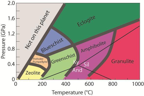
28 Figure 3.5 Metamorphic facies ( 15

29 Due to the complexity of the Namaqua-Natal Metamorphic Province a lot of authors have classified the rock types differently. This has caused some degree of confusion as there is not just one classification to follow. Two of the classifications are mentioned below. According to Moen (2007) the Namaqua Province is subdivided into three Subprovinces i.e. Bushmanland Subprovince, Gordonia Subprovince and the Kheis Subprovince. The subdivisions that are used in this study follow Cornell who says that the Namaqua sector is subdivided into five Subprovinces (Figure 3.6) (Cornell, et al., 2006). Figure 3.6 Tectonic subdivision of the Namaqua Sector, after (Cornell, et al., 2006). BoSZ: Boven Rugzeer Shear Zone, BSZ: Brakbosch Shear Zone, DT: Dabep Thrust, GT: Groothoek Thrust, HRT: Hartbees River Thrust, NSZ: Neusberg Shear Zone, PSZ: Pofadder Shear Zone (Cornell, et al., 2006). 16
30 Richtersveld Subprovince Geology The Richtersveld Subprovince as seen on Figure 3.4 falls between the Kakamas Terrane and the Bushmanland Terrane. It s western and southern boundary is the Groothoek Thrust and the eastern boundary is the Hartbees River Thrust. It covers an area of about km 2. Although it does not have distinguishable terranes it is referred to as a subprovince because it is a remnant of an originally much larger Kheisian cratonic block. It is primarily made up of a volcano-sedimentary sequence called the Orange River Group and the intrusive Vioolsdrif Suite (Figure 3.7) (Cornell, et al., 2006). The Orange River Group is comprised of highly variable aerial volcanic rocks and reworked volcaniclastic sediments. Displacement along stratigraphic contacts was caused by deformation long before the intrusion of the Vioolsdrif Suite; the suite just caused further disruption of the stratigraphic relationships (Moen, 2007) Structure & Metamorphism The Orange River Orogeny caused deformation and metamorphism in the Richtersveld Subprovince during the Kheisian (Palaeoproterozoic). The Orange River Orogeny occurred at the same time as the Eburnean and Ubendian in other parts of Africa. There was an early D 1 deformation that produced open to isoclinal folds. In the Vioolsdrif region there are a lot of exposed isoclinal F 1 folds that have been cut by the Vioolsdrif granites (Cornell, et al., 2006). A second generation of Namaquan F 2 folds exists which refolded the F 1 structures. The resulting F 2 structures and the intrusion of late Vioolsdrif granites give evidence 17

31 that the Orange River Orogeny was a polyphase event. According to radiometric dating D 1 took place at ~1900 Ma (Cornell, et al., 2006). Figure 3.7 Distribution of the Orange River Group in the Richtersveld Subprovince (Cornell, et al., 2006) Bushmanland Terrane Geology The Bushmanland Terrane trends east-west and is located to the west of the Kakamas Terrane and south of the Richtersveld Terrane. The eastern boundary of this terrane is the Hartbees River Thrust; the northern boundaries are the Groothoek Thrust and the Wortel Belt. The rocks in the west are overprinted by the West Coast 18
32 Belt while the rocks in the south are covered by the Vanrhynsdorp Group and the Karoo Supergroup (Cornell, et al., 2006). It is on an Eburnean basement. The domains of this terrane are made up of early, highly deformed supracrustal volcanosedimentary sequences that have been intruded by granitoids. Early supracrustal rocks were deposited on an older Eburnean floor of heterogeneous continental crust between ~ Ma. The Namaqua event that occurred at ~1100 Ma deformed basement and Namaqua rocks in the Bushmanland terrane (Thomas, et al., 1994) Structure & Metamorphism Like the Richtersveld Subprovince the Bushmanland Terrane is also characterised by a polyphase deformation history. There are two major tectonic episodes; D 2 and D 3. At Aggeneys and in the Gladkop Suite there is evidence for an early phase called D 1 which is found in metasedimentary xenoliths. These metasedimentary xenoliths led to the suggestion that pre-1800 Ma supracrustal sediments were present and therefore some of the D 1 structures could be correlated with deformation in the Richtersveld Subprovince. The D 2 event is regionally dominant and it produced a heterogeneous, locally intense, sub horizontal fabric parallel to the axial planes of tight to isoclinal, easttrending recumbent folds. The S 2 foliation is associated with a strong ENE-trending augen and mineral lineation. The end of D 2 is said to be around 1060 Ma. The structure of the Bushmanland Terrane can be summed up to be dominated by upright, ENE-trending, periclinal folds, and east-to southeast-trending shear zones. The metamorphic grade of the Bushmanland Terrane ranges from upper amphibolite facies to upper granulite facies (Figure 3.8). The upper amphibolite facies occurs in 19
. Figure 3.")
33 the north, north east and the south of the terrane and they have pressures and temperatures of 4 kbar, C. The upper granulite facies occurs in an ENEtrending belt around the Garies-Kliprand area in the south and they have temperatures and pressures of 5-7 kbar, 830 C (Cornell, et al., 2006). Figure 3.8 Map showing metamorphism in the Namaqua Sector and the Kaapvaal Craton (Cornell, et al., 2006). 20
34 Kakamas Terrane Geology The Kakamas Terrane lies to the west of the Areachap terrane and to the east of the Richtersveld Terrane and the Bushmanland Terrane. It is dominated by metasedimentary rocks as well as intrusions with varying degrees of deformation. These metasedimentary rocks are made up of deformed granulite to amphibolite gneisses, calc-silicates and feldspathic quartzites. The Neusspruit Shear Zone is an important NNW-trending structure that is located in the Kakamas Terrane and may have tectono-stratigraphic importance. To The east of the Neusspruit Shear Zone the terrane is dominated by high grade supracrustal rocks that are made up of arenites and calc-arenites. These rocks are grouped together as the Korannaland Group. To the west of the Neusspruit Shear Zone the terrane is made up of a supracrustal sequence consisting of high grade metapelites and biotite-garnet paragneisses which are known as Koelmanskop Metamorphic Suite (Cornell, et al., 2006). The ages of the supracrustal rocks as well as the pre-tectonic intrusive rocks are not known. It is only the syn-tectonic and post-tectonic intrusive rocks that have shown U-Pb zircon ages of between Ma. The rocks of the Kenhardt pegmatite belt gave ages of around Ma which makes them the youngest in the terrane (Cornell, et al., 2006). The area west of the Neusspruit Shear Zone is strongly dominated by pre-tectonic intrusive orthogneisses which are strongly deformed, show linear fabrics and contain xenoliths. The xenoliths are a sign of their plutonic origin. The orthogneisses have been subdivided into categories i.e. Riemvasmaak Gneiss (pink gneiss), Schuitdrift Gneiss (biotite augen gneiss), Yas and Polisiehoek Gneisses. The metasediments and orthogneisses east of Onseepkans have been intruded by syn-to late-tectonic 21
35 granitoids such as the Naros Granite, the Eendoorn Suite and the Stolzenfels Enderbite. The area east of the Neusspruit Shear Zone was intruded by syn-to post-tectonic granitoids which are grouped into the Keimoes Suite. These granitoids are biotite rich, weakly to moderately foliated and equigranular to porphyritic. The Friersdale Charnockite is a late tectonic granitoid that intruded earlier granitoids. The Kakamas terrane and the Areachap Terrane are stitched together by younger Keimoes Suite granitoids which post-date terrane amalgamation. Because the Keimoes Suite is made up of syn and post tectonic members it is not considered to be a single igneous suite (Cornell, et al., 2006). Table 3.1 below is a table compiled to show the different lithology descriptions by different authors. The formations mentioned all belong to the Kakamas Terrane. 22
36 Table 3.1 Table of lithologies as described by previous workers Formation Slabbert Van Bever Donker Von Backstrom Geringer Botha et al Praekelt Description Goede Hoop Used the name Neusberg Formation and subdivided it into a Neuspoort & Zwart Boois Berg Member (1980) Named the formation after a subdivision of the farm Biesje Poort 471 (1973) Micaceous quartzite with variable feldspar content, well sorted and rounded to ovoid quartz grains (Moen, 2007) Valsvlei Named the formation (1987) Yellow-weathering, quartz rich gneisses (Slabbert, 1987) Ganzenmond Proposed the name of the formation (1999) Mapped the area as part of his Wolfskop biotite gneiss (1980) Mapped the area as Aasvogelkop (1964) Brown to grey weathering, medium grained quartz-feldsparbiotite ± garnet ± sillimanite gneiss with lenses of amphibolite & calc-silicate rocks. (Slabbert, 1999) Rautenbach se Kop Grouped all the quartz-feldspar gneisses as Riemvasmaak Formation (1973) Reddish to grey quartzofeldspasthic gneiss, fine grained & equigranular, with a moderate to poorly developed foliation (Moen, 2007) 23
37 Table 3.1 continued Formation Slabbert Van Bever Donker Von Backstrom Geringer Botha et al Praekelt Description Puntsit Toeslaan Sandputs Recognised and named the formation (1985) Recognised and named the formation after a subdivision of a farm (1985) Called it the Baviaans Krantz banded calcsilicate quartzite (1980) Regarded the kinzigites as part of the Venterskop formation (1980) Described the formation as granulite containing lenses of calcsilicate rocks (1964) Recognised and named the formation after a railway station (1973) Regarded the quartzo-feldspathic rocks as Riemvasmaak Formation and the calc-silicate rocks as Biesje Poort Formation (1973) Formation which is widest spread. Darkweathering calc-silicate rocks with layers of marble & amphibolite. The calc-silicates differ in colour from light grey to green on fresh outcrop with a fine grained & granoblastic texture (Moen, 2007) Aluminous gneiss (kinzigite) & associated garnetiferous migmatite. Dark-grey, gneissic rock with variable grain size. Thin coat of desert varnish (black) (Moen, 2007) Feldspathic quartzite with varying calc-silicate minerals. These rocks grade into calc-silicate rocks completely in some places. Dark grey to greenish-grey calcsilicates occur as interstratified layers and lenses on all scales. The contacts are gradational and transition into the Puntsit Formation (Moen, 2007) 24
38 Table 3.1 continued Formation Slabbert Van Bever Donker Von Backstrom Geringer Botha et al Praekelt Description Omdraai Included this formation with his Maraisrivier Amphibolite (1980) Referred to the formation as Baviaanspoort quartz (sericite) schist (1949). He later referred to as quartz plagioclase schist (1964) Recognised and named the formation after farm Omdraai (1984) Upper part of the formation is heterogenous. Comprised of gneiss, quartzite (mature, fine grained and shows platy weathering), amphibolitic rocks & schist (Praekelt, 1984) Piet Rooisberg Proposed the name of the formation after a prominent hill (1985) Regarded the rocks as part of the Riemvasmaak Gneiss (1949) Referred to the rocks as the Kokerberg Formation (1976) Reddish brown weathering quartz feldspar gneiss. Medium to coarse grained, granitic appearance (Moen, 2007) 25
39 Structure & Metamorphism The Kakamas Terrane has four deformational events. D 1 was a fabric forming event and was followed by D 2 which is an isoclinal, non-cylindrical fold and thrust event. The D 3 event is made up of open, partially upright folds which were followed by wrench related folds accompanied by major strike-slip shear zones. D 3 superimposed on D 2 and as a result around 9 known domes formed, many of these domes are known to be over 10km in diameter. D 3 related folds die out towards the Hartbees River Thrust and D 2 deformation is most significant in the Kakamas Terrane. This led to the rotation of earlier D 1 /D 2 fabrics from east-west in the Bushmanland Terrane to northwest-southeast in the Kakamas Terrane. The Hartbees River Thrust is a structure related to D 1 /D 2 events. These events represent southwest directed thrusting after collision and accretion of the Namaqua continental mass with the Kaapvaal Craton. Subvertical northwest-trending shear zones of the latest D 4 event are related to northeast directed compression. The shape and angle of the indentor in the form of the Kaapvaal Craton caused the transcurrent shear system. Regional metamorphism along the Hartbees River Thrust belt reaches upper amphibolite facies (5 kbar, C) and is characterised by the presence of garnet-cordierite-potassium feldspar and garnet-biotite-sillimanite assemblages. The area around Onseepkans is comprised of granulite facies rocks characterised by the orthopyroxene-clinopyroxene-garnet assemblage. There are even lower amphibolite facies ( kbar, 550 C) assemblages in the area around the Boven Rugzeer Shear Zone with an assemblage of garnet-staurolite-andalusite (Figure 3.9) (Cornell, et al., 2006). 26
.")
40 Figure 3.9 The Geology of the Kakamas and Areachap Terranes (Cornell, et al., 2006) Areachap Terrane Geology The Areachap Terrane has the Kaaien Terrane to its east and the ±1100 Ma Kakamas Terrane to the west (Figure 3.10). The boundary between the Areachap Terrane and the Kaaien Terrane is the Brakbosch Shear Zone which is said to be an early thrust related to the beginning of the Namaquan collision. This shear zone was later reactivated as a dextral transcurrent shear zone. It is comprised of a NNW trending belt of ~1300 Ma amphibolite grade metabasic and intermediate supracrustal gneisses which have been intruded by the Keimoes Suite granitoids. The area is extremely deformed and shows four different deformation phases. These deformations are such that interference patterns developed but have been 27
41 displaced by shear zones (Van Bever Donker, 1991). They reach amphibolite to granulite metamorphic facies. This makes them more of a higher grade than those to the east (Petterson et al. (2007). Van Bever Donker (1991) suggests an oblique collision of the Namaqua Natal Province with a pointed rigid Kaapvaal craton acting as an indentor. The Namaqua Natal Province collided with the Kaapvaal Craton and the Kheis Province experienced thrusting. This collision led to the flattening of the indentor which then changed the orientation of the stress field causing interference structures as the two blocks moved closer together. This terrane is different from any other terrane in the province in that it has massive sulphides and the arc related origin of its juvenile metavolcanic components which have no Kheisian basement but are just Namaquan. The absence of Kheisian basement distinguishes it from both the Kakamas Terrane and the Bushmanland Terrane (Cornell, et al., 2006) Structure & Metamorphism Cornell et al. (2006) provides a regional framework for our understanding of the structure, metamorphism and tectonic setting of crustal rocks in the Areachap region. An ocean basin developed between 1600 Ma and 1350 Ma as a result of rifting. Subduction zones developed and island arcs formed at 1320 to 1270 Ma. These island arcs are made of basaltic and intermediate volcanic rocks, with turbidites, volcanic exhalative ore deposits formed in back arc basins. These arcs collided with and overthrusted on the Kaapvaal Craton as subduction continued at ~1220 to 1210 Ma. This led to F 1 nappe-like folds, crustal thickening, granitoid intrusions and medium pressure (staurolite-kyanite) M 1 metamorphism. There was a 100 Ma period that went by without any dateable tectonic activity. At around 1000 Ma the lower crust melted and this led to the intrusion of granite, 28
 M 4 metamorphism in F 3 and F 4 shear zones (Cornell, et al., 2006).")
42 anorthosite and charnockite which caused M 2 thermal and M 3 hydrothermal peaks in low pressure (cordierite-garnet-sillimanite) granulite facies and compressional F 2 folding. Between 1080 and 965 Ma there was erosional exhumation, uplift and cooling with retrograde medium pressure (staurolite-kyanite) M 4 metamorphism in F 3 and F 4 shear zones (Cornell, et al., 2006). Figure 3.10 Map showing the distribution and lithostratigraphy of the Areachap Terrane (Cornell, et al., 2006). 29
43 Kaaien Terrane Geology The Kaaien Terrane is a tectono-stratigraphic entity, which forms the eastern foreland of the Namaqua Province. It is made up of thick sequences of deformed quartzite which make a transition from the Kaapvaal Craton and the Kheis Province to the high grade rocks of the Areachap Terrane. Its eastern boundary with the Areachap Terrane is the Brakbosch-Trooilapspan Shear Zone and its western boundary with the Kheis Province is the Dabep Thrust. Its main stratigraphic components are the Brulpan, Vaalkoppies, Wilgenhoutsdrif and Koras Groups (Cornell, et al., 2006) Structure & Metamorphism The Kaaien Terrane which lies in the Namaqua Front region shows clear influence of the Namaqua tectonism but the Kheisian Orogeny cannot be recognised. The Brulpan, Vaalkoppies and Wilgenhoutsdrif Groups have undergone many phases of isoclinal folding, low grade thermal metamorphism and granite emplacement. Early isoclinal D 1 folds were refolded by later northwest trending macroscopic folds of the second D 2 Namaqua deformation. Towards the west of the Brakbosch Shear Zone the D 1 planar foliation was rotated parallel to the D 2 foliation which made them hard to distinguish. The D 2 Namaqua deformation produced open, northwest plunging folds. There is also a large-scale dextral shear movement (D 3 ) that was recognised (Cornell, et al., 2006). 30
44 3.2.3 Natal Sector Of lesser importance to this study is the Natal sector of the Namaqua-Natal Metamorphic Province. The Natal Sector is made up of three different tectono-stratigraphic terranes which are south of the Kaapvaal Craton. The three terranes are the Tugela Terrane, Mzumbe Terrane and the Margate Terrane (Figure 3.11). At around 1135 Ma these terranes were thrust NE over the southern margin of the craton when they collided with each other. They are made up of juvenile Mesoproterozoic crust which formed as island arcs as subduction continued. These arcs and the craton collided at an oblique angle which resulted in the crust thickening causing sinistral transpression and crustal escape tectonics along major ductile shear zones. This was followed by intrusion of rapakivi-textured granitoids and charnockites in a transcurrent tectonic setting, associated with high-t, moderate-p granulite-grade metamorphism between 1070 and 1030 Ma. The youngest intrusions in Natal are microgranite dykes which were emplaced at ca Ma (Jaobs, et al., 2008). 31

45 Figure 3.11 Map showing the Natal Metamorphic Province with the three terranes: Tugela, Mzumbe and Margate (Cornell, et al., 2006). 32
46 3.3 Local Geology The local geology of the area under study falls under the Korannaland Group. Table 3.2 Namaqua Province stratigraphic column based on a classification by Moen (2007). Province Subprovince Group Subgroup Formation Bushmanland Namaqua Gordonia Korannaland Biesje Poort Kheis Goede Hoop Valsvlei Ganzenmond Rautenbach se Kop Puntsit Toeslaan Sandputs Omdraai Piet Rooisberg Korannaland Group The area under study is to the east of the Neusspruit shear zone and to the west of the Trooilapspan shear zone. It falls under the Korannaland Group which was previously known as the Korannaland Supergroup and is restricted only to the Gordonia Subprovince (Moen, 2007). There are different rock types comprising this Subprovince and they are grouped together under the Biesje Poort Subgroup. 33
47 Biesje Poort Subgroup The term Biesje Poort formation was coined by Geringer (1973), cited in Moen (2007); it refers to a formation north of Kakamas which consists of quartz-rich, semipelitic and metapelitic metasediments. The rocks of this succession were so complicated that this formation was upgraded to a subgroup (Moen, 2007). This subgroup is made up of nine formations (Table 3.2). The following classification is based on Moen (2007): Piet Rooisberg Formation The name Piet Rooisberg was introduced by Slabbert (1987). This formation is made up of red-brown weathering quartz-feldspar gneiss that is said to be similar to the Riemvasmaak Gneiss and the Rautenbach se Kop Formation. The gneiss has a granitic appearance and is coarse grained. The major minerals are quartz and microcline and the accessory minerals are plagioclase, biotite, hornblende and titanite. The gneiss has a poorly developed foliation due to the lack of biotite. Although the origin of the Piet Rooisberg Formation is not fully known some authors have come up with various possibilities. Poldervaart & Von Backstrom (1949) cited in Moen (2007) regarded this formation as part of the Riemvasmaak Gneiss because of the lack of sharp contacts with metasedimentary rocks, lack of magmatic xenoliths and rounded zircon grains. Harris (1985) interpreted the formation as having a granitic core which was not very different from the upper and lower parts of the formation and therefore referred to it as a paragneiss. Moen (2007) interpreted the formation as a granitic intrusion because of its similarity to the Riemvasmaak Gneiss. 34
48 Omdraai Formation The Omdraai Formation is comprised of schistose, leucocratic and well bedded semipelitic metasediments. This formation was first named by Praekelt (1984) after the farm Omdraai 492. These rocks are surrounded by the Riemvasmaak Gneiss, their contacts are unclear and appear gradational, and this is especially true in areas where the composition of the metasediments is quartzofeldspathic. This formation is said to be easily differentiated from the Riemvasmaak Gneiss because of its leucocratic nature and the presence of lithological banding. This leucocratic, medium to fine grained quartz feldspar gneiss lacks hornblende and has very little to no biotite and as a result of this it has a poorly developed foliation. In some areas there are thin alternating bands of leucogneiss and biotite rich gneiss Sandputs Formation This formation was named by Slabbert (1987) cited in Moen (2007). It is said that this formation is comprised of feldspathic quartzite with varying amounts of calcsilicate minerals. In some places the rocks of this formation completely change into calc-silicates. This is said to make the boundary between the Sandputs Formation and the Puntsit Formation very difficult to deduce. As a result of the complexity of the area different authors have had difficulty agreeing on one name and interpretation. Von Backstrom (1964) interpreted this formation as being part of his Aasvogelkop Granulite while Van Bever Donker (1980) referred to these rocks as part of his Wolfskop Biotite Gneiss because he could not distinguish them from the pink gneiss. The confusion resulted because as the feldspar content increases and the calc-silicate minerals decrease the quartzofeldspathic rocks grade into brown-weathering gneiss (Moen, 2007). 35
49 The Sandputs Formation is a fine grained, grey to brown weathering quartzitic rock with a laminar texture. In some areas as the feldspar content increases and the calc-silicate content decreases these rocks can grade into brown weathering gneiss. The rocks of the Sandputs, Puntsit and Rautenbach se Kop Formations are closely associated and their gradational contacts indicate that the formations were formed from a continuous sedimentary cycle which had abundant siliceous, calcareous and arkosic deposits (Moen, 2007) Toeslaan Formation The Toeslaan Formation was identified by Geringer (1973) and named after a railway station. It is made up of aluminous gneiss (kinzigite). According to Moen (2007) kinzigites represent the end product of processes that take place during high grade metamorphism. Lithologically the kinzigite is a gneissic rock that is dark grey in colour and has variable grain size. Mineralogically kinzigites are comprised of quartz, microcline, plagioclase, cordierite, garnet, biotite and sillimanite. Kinzigites formed as a result of high grade regional metamorphism and the mineralogy of the kinzigites was affected by contact metasomatic processes. Schultz (1978) documented the P-T conditions as C at 4±1 kb and Van Bever Donker (1980) documented the P-T conditions as >700 C at 5 kb during what he considered to be regional phase of metamorphism (M1) and 550 C at 5.5 kb during contact metamorphism phase (M2) (Moen, 2007). 36
50 Puntsit Formation The Puntsit formation was recognised and named by Slabbert (1985) cited in Moen (2007). It is made up of dark weathering calc-silicate rocks that have layers of amphibolite and marble. It is sometimes hard to distinguish from the Sandputs Formation because of their gradational relationship. This formation overlies the Sandputs Formation with a gradational contact and it is in turn overlain by the Goede Hoop Formation. This formation is fine grained and granoblastic with a light grey or green to almost white in fresh surfaces. There are no visible sedimentary structures. In places that bear Wollastonite or carbonate layers the outcrop bears elephant hide weathering. There is distinct banding caused by varying amounts of amphibole, epidote and diopside. The thin carbonate horizons show small scale internal folding and give rise to a pinch and swell morphology (Figure 3.12) (Moen, 2007). One of the characteristic features of this formation is the presence of marble layers which can range from 30 m to 1 m. There are horizons of impure carbonate with layers of calc-silicate rocks, diffuse zones or porphyroblasts of Wollastonite. 37

51 Figure 3.12 Intense internal small scale folding and pinch and swell morphology displayed by Wollastonite of the Puntsit Formation Rautenbach se Kop Formation The Rautenbach se Kop Formation was named after a prominent hill of a farm adjacent to it. It is a reddish to grey quartzofeldspathic gneiss, fine grained & equigranular, with a poor to moderately developed foliation. It occurs as a continuous band that separates the Goede Hoop Formation from the Puntsit Formation. This formation is sometimes found in the core of synclinal folds in the calc-silicate successions of the Puntsit Formation (Moen, 2007). Its contacts with other formations vary from gradational to sharp. In some areas the Rautenbach se Kop Formation structurally overlies the Goede Hoop Formation but evidence from cross-bedding suggests that the contact is overturned. This therefore 38
52 means that stratigraphically the Rautenbach se Kop overlies the Puntsit Formation which is overlain by the Goede Hoop Formation (Moen, 2007). It weathers to a dark-red to red-brown colour; this makes it difficult to distinguish from the Riemvasmaak Gneiss. Although it has feldspar porphyroblasts that can have a diameter of 10 mm they can be differentiated from the Riemvasmaak Gneiss by the general lack of augen Ganzenmond Formation The name Ganzenmond Formation was proposed by Slabbert et al. (1999) cited in Moen (2007). This formation is brown to grey weathering, medium grained quartzfeldspar-biotite ± garnet ± sillimanite gneiss with lenses of amphibolite and of calcsilicate rocks. It is predominantly made of potassium feldspar with minute amounts of biotite; there is no garnet present. There is an abundance of long corundum crystals near the contact of the Ganzenmond Formation and the Friersdale Charnockite. They also form as xenoliths within the Charnockite surrounded by grey coronas with biotite, tourmaline, magnetite and plagioclase. The occurrence of the corundum in close proximity to the intrusive contacts suggests that it formed by contact metamorphism. The Ganzenmond Formation is considered to be a lateral variation of the Valsvlei Formation (Moen, 2007) Valsvlei Formation This formation was named by Slabbert. The Valsvlei Formation is comprised of yellow weathering, quartz rich gneisses (Slabbert, 1987). This formation is poorly exposed and it underlies a flat area with a few low hills. The weathering surface is rough and crumbly and the primary layering is planar though not seen in many areas. 39
53 The lithology of the formation is a quartzitic gneiss which is made up of ~80% quartz, potassium feldspar and muscovite with accessory biotite, sillimanite, epidote and magnetite. The wide spread shearing has caused the feldspars to be sericitized and the biotite to be partly chloritised. On Gif Berg 58 the base of the formation has a layer of calc-silicate rocks which reaches thicknesses of 20 m. This layer of calcsilicates has a dark grey to green colour and is made up of quartz, feldspars, diopside, hornblende, scapolite and biotite. The top of the formation has a layer of metapelitic rocks known as kinzigite (Von Backstrom, 1964). This layer is made up of quartz, feldspar, biotite, cordierite, sillimanite and garnet. Its texture is fine grained with an irregular banding Goede Hoop Formation According to Moen (2007) this formation was named by Geringer (1973) after a subdivision of the farm Biesje Poort 471. This formation occurs to the east of the Neusspruit shear zone, it is comprised of quartzite that is muscovite rich and transforms into a schistose rock when strongly deformed. This formation extends from the Melkboom dome in a north-westerly direction to the Warm Zand dome. From the Warm Zand dome it continues as two parallel belts; the south western one ends in the Riemvasmaak Gneiss and the north eastern one disappears under the Nama Group. The Goede Hoop Formation is associated with the Puntsit Formation that underlies it throughout most of its distribution. There are no known Mesoproterozoic rocks that overlie this formation so this makes it stratigraphically the youngest of the Korannaland Group (Moen, 2007). Lithology wise the Goede Hoop Formation is comprised of a uniform succession of micaceous quartzites with variable content of feldspar. The micaceous quartzites appear well foliated with a high degree of weathering, they also appear glittery. It is 40
54 fine grained and light grey to whitish in colour. This micaceous quartzite grades into pure quartzite in some areas but the mica content is never absent entirely. The foliation is parallel to bedding. Despite the deformation some sedimentary structures such as bedding planes, graded-bedding and cross-bedding are well preserved. The feldspathic quartzites appear massive and gneissic and have a brownish weathering colour (Moen, 2007). The quartzite is well sorted and it has an average grain size of ~0.7 mm. The quartz grains are rounded to ovoid in shape and recrystallized. Near the base of the succession there are scattered pebbles, pebbly layers and matrix supported conglomerates. These pebbles are small, rounded and deformed into ovoid shapes which are ~100 mm long (Moen, 2007). 41
55 3.4 Keimoes Suite Widespread mapping of the Kakamas Terrane, Areachap Terrane and Kaaien Terrane led to the discovery of quite a number of granitoids The Keimoes Suite is a suite that is comprised of many different plutonic rocks which are confined to an area between the Neusspruit shear zone and the Brakbosch fault. They are weakly to well foliated non-garnetiferous and non-porphyroblastic biotite, biotite-hornblende and charnockitic granitoids (Moen, 2007). As previously mentioned the Keimoes Suite is made up of granitoids that are pretectonic, syn-tectonic and post-tectonic. Figure 3.13 shows the different locations of the Keimoes Suite granitoids and Table 3.3 shows the ages of the granitoids from the Kakamas Terrane, Areachap Terrane and the Kaaien Terrane. 42

56 Figure 3.13 The distribution of the different granitoids of the Keimoes Suite and the Augrabies Suite modified after (Cornell, et al., 2012). 43
57 Table 3.3 Shows a summary of ion probe zircon dating for granitoids, volcanic rocks as well as metamorphic events located in the Kakamas, Areachap and Kaaien Terranes. Not all the granitoids appear in Figure 3.13 (Cornell, et al., 2012). Event dated Age Ma 2δ Reference Kakamas Terrane Vaalputs Granite Metamorphism Pettersson 2009 Friersdale Charnockite Intrusion Cornell et al., 2012 Beenbreek Gneiss Intrusion Pettersson 2008 Vaalputs Granite Intrusion Pettersson 2008 Riemvasmaak Gneiss Intrusion Pettersson 2008 Dyasons Klip Granite Metamorphism Pettersson 2008 Kenhardt Fn migmatite Metamorphism Fransson 2008 Kenhardt Fn biotite gneiss Metamorphism Cornell and Pettersson 2007 Kenhardt Fn biotite gneiss Protolith Magma Cornell and Pettersson 2007 Polisiehoek Granite Intrusion Pettersson 2008 Kenhardt Fn migmatite Protolith Magma Fransson 2008 Dyasons Klip Granite Intrusion Pettersson 2008 Areachap Terrane Friersdale Charnockite Intrusion Cornell et al., 2012 Straussburg Granite Intrusion Cornell et al., 2012 Rooiputs Granophyre Intrusion Pettersson et al., 2008 Bloubos Granite Intrusion Pettersson et al., 2009 Klip Koppies Granite Intrusion Baillie et al., 2011a Kleinbegin Granite Intrusion Baillie et al., 2011a Gemsbokbult Granite Intrusion Baillie et al., 2011a Jannelsepan Fn Lava Metamorphism Baillie 2008 Riemvasmaak Gneiss Intrusion Pettersson 2008 Jannelsepan Migmatite Metamorphism Pettersson et al., 2007 Bethesda Fn metapelite Metamorphism Fransson 2008 Boksputs Fn metaquartzite Metamorphism Cornell and Pettersson 2007 Jannelsepan Fn Lava Extrusion Pettersson et al., 2007 Jannelsepan Fn Lava Extrusion Baillie 2008 Josling Granite Intrusion Pettersson 2008 Jannelsepan Fn volcanism Extrusion Cornell and Pettersson 2007 Kaaien Terrane Leeuwdraai Fn Koras Gp Extrusion Pettersson et al., 2007 Leeuwdraai Fn Koras Gp Extrusion Pettersson et al., 2007 Leeuwdraai Fn Koras Gp Extrusion Pettersson et al., 2007 Swartkopsleegte Fn Koras Gp Extrusion Gutzmer et al., 2000 Swartkopsleegte Fn Koras Gp Extrusion Pettersson 2008 Leerkrans Fn Wilgenhoutsdrif Gp Extrusion Baillie et al., 2011b Wilgenhoutsdrif Lava Extrusion Moen and Armstrong 2008 Kalkwerf Gneiss Intrusion Moen and Armstrong 2008 Swanartz Gneiss Intrusion Pettersson et al.,

58 45
59 4 LITHOLOGY/ PETROGRAPHY OF THE STUDY AREA The area under investigation is comprised of rocks of the Biesje Poort Subgroup. It is made up of quartzites, calc-silicates and biotite gneiss. There are also intrusive rocks which belong to the Keimoes Suite and they are granites and charnockites, which intruded between Ma (Geringer, et al., 1988) (Table 3.2). 4.1 Quartzite Field Appearance The quartzite is comprised of many minerals but the only ones visible on the hand specimen are quartz, alkali feldspar and biotite. The quartz is rounded and medium to coarse grained. The feldspar has a pinkish-brown colour that weathers into an orange-brown colour. The biotite is flaky with a black colour that weathers into a brown-gold colour (Figure 4.1). The quartzites of farm Koekoeb B (study area) have high contents of biotite and as a result they are more prone to weathering as biotite is a sheet silicate. A sheet silicate mineral is formed by parallel sheets of silicates which flake off easily. These observations were made from the field. 46
 There are some areas with preserved primary sedimentary features such as crossbedding, as observed by Van Bever Donker (1980)")
60 Joint set 1 Joint set Joint set 2 Figure 4.1 Weathered quartzite showing three sets of joints (blue pen= 15cm) There are some areas with preserved primary sedimentary features such as crossbedding, as observed by Van Bever Donker (1980) (Figure 4.2). The direction of cross-bedding shows that the outcrops have not been overturned. The parent rock from which quartzites form are sandstones that have been metamorphosed. Sandstones are moderately high-energy continental rocks. According to literature quartzites belong to either the Goede Hoop formation or the Sandputs formation (Moen, 2007). In this investigation the quartzites are believed to belong to the Goede Hoop formation because according to Moen (2007) the quartzite of the Goede Hoop formation are associated with the calc-silicates of the 47

61 Puntsit formation and they have preserved sedimentary structures, this is the case in farm Koekoeb B of Kakamas. Flow Direction Original Up Direction Figure 4.2 Quartzite showing preserved sedimentary features i.e. cross-bedding in green (white pencil= 12cm) Petrography This rock consists of Quartz (45%), Feldspar (35%) and Biotite (15%) and Plagioclase (5%) (Figure 4.3) The mineral quartz has a grain shape that is anhedral. It appears clear under plane polarised light and white to grey under cross polarised light. It is the main constituent of the rock. It occupies approximately 45% of the total rock volume. The mineral feldspar is fine grained groundmass. The feldspar is weathered with small bits of it that are not sericitised and takes up 35% of the total rock volume. Plagioclase shows twinning and it takes up 15% of the total rock volume. 48
 Crossed polarised light b) Crossed polars with retardation plate inserted and c) Plane polarised light.")
62 The mineral biotite has a variable grain shape with elongated minerals being more common. It occupies approximately 5% of the total rock volume. A Fspar B Q B P C Figure 4.3 Quartzite in thin section a) Crossed polarised light b) Crossed polars with retardation plate inserted and c) Plane polarised light. Q-Quartz, Fspar-Feldspar, B-Biotite and P-Plagioclase (scale bar= 2mm). 49

63 4.1.3 Conclusion The quartzite has a granoblastic polygonal polymineralic texture. The elongated biotite minerals are randomly oriented. Because of the biotite constitutes only 15% of the whole rock volume there are more quartz-quartz boundaries. The minerals present in quartzite suggest that the rock reached amphibolite facies metamorphic grade. 4.2 Biotite Gneiss Field Appearance The biotite gneiss is comprised of quartz, alkali feldspar and biotite. The quartz is medium grained with a light colour that weathers to brown. The feldspar porphyroclasts are large (5-10 mm across) and rounded, they are orange-brown in colour. The biotite is flaky and black in colour; it weathers to a brown-gold colour (Figure 4.4). Figure 4.4 Biotite Gneiss (compass= 10cm) 50
 a chilled margin or baked zone occurs when a hot magma intrudes into relatively cold country rock, this causes the margins of the intrusion to cool more rapidly than the")
64 It mostly occurs on what is referred to as baked zones or chilled margins (Figure 4.5). According to Nelson (2012) a chilled margin or baked zone occurs when a hot magma intrudes into relatively cold country rock, this causes the margins of the intrusion to cool more rapidly than the interior while simultaneously heating up the country rock at the point of contact. This is a proof that the intrusive rocks are younger than the surrounding country rock. There may have been fluids that reacted with the country rock during contact metamorphism. Figure 4.5 Diagram depicting a baked zone (Nelson, 2012). There are no visible structures on the biotite gneiss. The contacts between the quartzite and biotite gneiss are very sharp (Figure 4.6). Gneiss is a metamorphic rock that formed from the metamorphism of either sedimentary or igneous rocks. As far as formation classification is concerned this rock type does not belong to any because it is a contact metamorphism feature. 51
, Quartz (45%), Feldspar (30%) and Chlorite (2%) (Figure 4.7).")
65 Quartzite Biotite Gneiss Figure 4.6 Quartzite-Biotite Gneiss Contact indicated by the red dotted line (hammer= 35cm) Petrography This rock consists of Biotite (23%), Quartz (45%), Feldspar (30%) and Chlorite (2%) (Figure 4.7). The mineral biotite exhibits a euhedral grain shape and defines a foliation and occupies approximately 23% of the total rock volume, giving the rock its foliated appearance. The mineral quartz has a grain shape that is anhedral and lacks cleavage. It appears clear under plane polarised light and white to grey under cross polarised light. It is the main constituent of the rock apart from feldspar and occupies approximately 45% of the total rock volume. 52
66 The mineral feldspar is a fine grained groundmass surrounding the biotite. The feldspar is weathered and takes up 30% of the total rock volume. Feldspar and quartz are hard to distinguish under plane polarised light although quartz is a bit lighter. They are better distinguished under polarised light with crossed Nichols as quartz is uniaxial and feldspar is bi-axial. There appears to be chlorite which could be a sign of chloritisation of biotite. The chlorite is in contact with biotite (Figure 4.7). 53
 Plane polarised light and (b) Cross polarised light.")
67 A B Q Fspar Cl B Q Figure 4.7 Thin section of Biotite Gneiss in (a) Plane polarised light and (b) Cross polarised light. Q- Quartz, B-Biotite, Fspar-Feldspar is sericitised, Cl-Chloritisation (scale bar= 2mm) 54

68 4.2.3 Conclusion The biotite is elongated and has a preferred orientation. As highlighted in Figure 4.7 there is chloritisation of the biotite, the presence of chlorite is usually a sign of retrograde metamorphism. This is evidence of the rock reaching amphibolite facies before cooling down to low grade greenschist facies. 4.3 Calc-silicate Field Appearance The calc-silicate is a medium grained rock that is dark grey with a greenish colour. The green is from the presence of epidote. It has an abundance of quartz veins and amphibolite (Figure 4.8). In some places it contains deformed Wollastonite rich limestone. Figure 4.8 Jointed calc-silicate with quartz veins 55
69 A calc-silicate is a metamorphic rock that consists of calcium bearing silicates. It is formed by metamorphism of impure limestone. These rocks are typically deposited in marine environments. These rocks are classified as the Puntsit formation because Moen (2007) describes the presence of Wollastonite as a characteristic feature of this formation. Figure 4.9 and Figure 4.10 show the typical behaviour of the calc-silicates as described by Moen (2007). The impure carbonate contains layers of calc-silicate and Wollastonite. The disharmonic folds and pinch and swell structures result from the competency contrast between the marble and calc-silicate. Figure 4.9 Typical pinch and swell morphology in folded wollastonite-bearing calc-silicate rocks 56
, Feldspar (30%), Amphibole (5%) and Epidote (10%) The mineral quartz has a grain shape that is anhedral.")
70 Figure 4.10 Intense small scale folding in wollastonite-bearing calc-silicates Petrography The calc-silicate is comprised of mostly quartz and feldspar (Figure 4.11). It consists of Quartz (45%), Feldspar (30%), Amphibole (5%) and Epidote (10%) The mineral quartz has a grain shape that is anhedral. It is the main constituent of the rock and occupies approximately 45% of the total rock volume. The mineral feldspar is a fine grained groundmass. The feldspar is weathered and takes up 30% of the total rock volume. 57
 Crossed polars b) Crossed polars with retardation plate inserted and c) Plane polarised light.")
71 Amphibole constitutes 5% of the total rock volume and is light brown in colour under crossed polars. Epidote makes up 10% of the rock and has high interference colours under crossed polars. A Fspar A E Q B C Figure 4.11 Calc-silicate in thin section a) Crossed polars b) Crossed polars with retardation plate inserted and c) Plane polarised light. Fspar-Feldspar, Q-Quartz, E-Epidote and A-Amphibole (scale bar= 4mm) 58

72 4.3.3 Conclusion The presence of epidote suggests that the rock reached greenschist facies. Based on the minerals present in the calc-silicate, the rock prograded to amphibolite facies metamorphic grade. 4.4 Wollastonite Field Appearance The wollastonite-bearing calcareous rock is an outcrop associated with the metamorphism of impure limestone. From the position of this calcareous rock in Koekoeb B it seems highly likely that it formed as a result of contact metamorphism between the charnockite and the calc-silicate. It is fine grained with a wavy appearance (Figure 4.12). Figure 4.12 Weathered wollastonite showing a wavy appearance which could be due to folding of the area 59

73 Figure 4.13 Fresh outcrop showing the green colour of Wollastonite It demonstrates a rough weathering brownish surface which resembles that of an elephant hide; fresh outcrops are green in colour which suggests substantial amounts of epidote (Figure 4.13). Wollastonite usually occurs as a result of high temperature metamorphism of impure limestone. In most occurrences it is the result of the following reaction between calcite and silica with the loss of carbon dioxide (decarbonisation): CaCO 3 + SiO 2 CaSiO 3 + CO 2 (Wilford, 1956) 60
 is referred to as a devolatization reaction. The Wollastonite reaction is dependent on both temperature and pressure. It can form under very low pressure.")
74 Figure 4.14 Equilibrium phase relationships between calcite, quartz, wollastonite and CO 2 ( 2013) This metamorphic reaction (Figure 4.14) is referred to as a devolatization reaction. The Wollastonite reaction is dependent on both temperature and pressure. It can form under very low pressure. This is why it forms as a result of contact metamorphism when magma intrudes a limestone. This Pressure-Temperature determination method would not be very useful in this study as the CO 2 pressure is unknown. 61
75 4.5 Granitoid Field Appearance The granitoids in the Kakamas Terrane are coarse grained, biotite-rich and moderately to strongly foliated. This made them hard to differentiate from biotite gneiss in some locations. They have elongate mafic xenoliths that run parallel to the foliation (Figure 4.15). The xenoliths could more likely be remnants of the dark coloured calc-silicate. The orientation of the xenoliths implies that they formed under the same stress regime as the foliation. The fabric could have resulted from the flow of magma during the intrusion. Figure 4.15 Moderately to strongly foliated Granite with lenticular mafic xenoliths 62
76 4.5.2 Petrography The granitoid consists of Quartz (30%), Feldspar (45%), Biotite (15%), Pyroxene (5%) and Plagioclase (5%) (Figure 4.16) The mineral biotite exhibits a euhedral grain shape and takes up 15% of the total rock volume. This granite would be better classified as a biotite granite because of the abundance of the mineral biotite. Quartz has anhedral to subhedral grains. It occupies 30% of the total rock volume. The mineral potassium feldspar occurs as a fine-grained groundmass surrounding the biotite and quartz minerals. The feldspar is sericitized due to weathering. It makes up takes up 45% of the total rock volume. The mineral plagioclase is seen at the bottom of Figure 4.16B. It has a twinned appearance. Twinning represents phase changes in crystals that appear as one to the naked eye but are in fact two or more individual crystals. The twinning results from the crystals exhibiting differences in their birefringence under crossed polars. It makes up 5% of the total rock volume. Pyroxene is an anisotropic mineral that constitutes 5% of the total rock volume 63
 Crossed polars with a retardation plate inserted and b) Crossed polars.")
77 A B Fspar B Py Q P Figure 4.16 Granitoid in thin section under a) Crossed polars with a retardation plate inserted and b) Crossed polars. Q-Quartz, Fspar-Feldspar, P-Plagioclase and B-Biotite and Py-Pyroxene (scale bar= 4mm) 64

78 4.6 Charnockite Field Appearance The hand specimen shows that it is a granitoid which is blue-dark grey in colour with its distinctive blue opalescent quartz. The blue quartz is the primary way of distinguishing the charnockite from the other granitoids. It has medium to coarse grains that are equigranular. It has onion skin weathering. The charnockite has no foliation (Figure 4.17). Figure 4.17 Charnockite with joints and a quartz vein Throughout the area the charnockite has quartz filled veins as well as numerous large pegmatites (~200m long and 10m wide) that are parallel to one another (Figure 4.18). Veins and pegmatites are deposited when minerals that were carried in a solution are precipitated. The charnockite belongs to the Friersdale Charnockite of the Keimoes Suite. 65

79 Figure 4.18 Quartz Pegmatite (height of man= 1.7m) Petrography This rock consists of Quartz (40%), Black Feldspar (30%), Biotite (10%), Orthopyroxene (5%) and Plagioclase (15%) (Figure 4.19). The mineral biotite is fine-grained in places and in others has no grain shape. It occupies approximately 10% of the total rock volume. The mineral quartz has a grain shape that is anhedral. It appears clear under plane polarised light and white to grey under cross polarised light. It is the main constituent of the rock apart from feldspar and occupies approximately 40% of the total rock volume. The mineral feldspar is a fine grained groundmass surrounding quartz. The feldspar is weathered and takes up 30% of the total rock volume. 66

80 Plagioclase shows twinning and it takes up 15% of the total rock volume. Pyroxene takes up 5% of the total rock volume. It appears brown under cross polarised light and a brighter colour when the retardation plate is inserted. A B C Q B Py Fspar P Figure 4.19 Thin section Charnockite in a) Retardation plate inserted; b) Crossed polars and c) Plane polarised light. Q-Quartz, Fspar-Feldspar, P-Plagioclase, B-Biotite and Py-Pyroxene. (scale bar= 2mm) Conclusion Charnockite is another intrusive rock of the Keimoes Suite. Zircon dating suggests that it may be the youngest of the suite. 67
81 5 METAMORPHISM Metamorphism as previously mentioned is a process whereby rocks are altered as a result of temperature and pressure variations and introduction of chemically active fluids. The minerals in the rocks are altered differently according to their chemical composition. There are varying degrees of metamorphism; these are referred to as metamorphic grades. They depend on temperature and pressure. Low grade metamorphism results from relatively low temperatures and pressures. Medium grade metamorphism involves temperatures and pressures that are higher than those experienced in low grade metamorphism. High grade metamorphism results from extremely high temperatures and pressures; these conditions are common on convergent tectonic settings. 5.1 Regional Metamorphism Figure 5.1 is a representation of all the different scenarios under regional metamorphism. All of these scenarios form different minerals and rocks. The image shows the results of a collision between a continental crust and an oceanic crust. Regional metamorphism is related to contact metamorphism in that the latter is a byproduct of the former. 68

82 Figure 5.1 Diagram depicting regional metamorphism ( 2005) The Kakamas Terrane was deposited and buried and compacted, this was the fabric forming event. With burial came diagenesis then later regional metamorphism as a result of confining pressure from the overburden. At this time the sandstones and limestones of Koekoeb B were metamorphosed into quartzites and calc-silicates respectively. Another form of regional metamorphism occurred when the Bushmanland fragment collided with the Kheis-Kaapvaal Craton and caused major regional deformation. All the folds and shear zones resulted from this collision. Figure 5.2 shows the different facies at different temperatures and pressures with depth. With a change in temperature and pressure certain minerals become unstable and transition into a mineral that is more stable at those particular conditions. 69
 The minerals found in Koekoeb B under a light microscope are typical of the lithologies.")

83 Figure 5.2 Metamorphic facies boundaries (Winter, 2001) The minerals found in Koekoeb B under a light microscope are typical of the lithologies. The mineral chlorite indicates low grade metamorphism; biotite and muscovite indicate low to intermediate grade metamorphism (Figure 5.3). It is very hard to determine a grade of metamorphism from quartz and feldspar because they are present in all classes of metamorphism and all rock types in the study area. Figure 5.3 Zones and Index minerals associated with metamorphic facies boundaries ( 2000) 70
84 5.2 Contact Metamorphism Contact metamorphism is a local kind of metamorphism. It occurs on a smaller scale than regional metamorphism. It mostly occurs in regions of convergent margins where magma rises and heats up surrounding rock. Koekoeb B experienced contact metamorphism; it resulted in the presence of biotite gneiss which surrounds the quartzites which are adjacent to the Friersdale Charnockite. The Friersdale Charnockite intruded the Kakamas Terrane at great depths. The evidence of this is the formation of biotite gneiss as a contact aureole. Gneisses form at late intermediate to high grade metamorphism (Figure 5.3). High temperatures alone could not have formed the foliated biotite gneiss because pressure is needed to form foliation on a rock. 5.3 Causes of Metamorphism The three causes of metamorphism can act independently or collectively. The three metamorphism agents are: Temperature Temperatures changes occur for a number of reasons. The most commonly dealt with temperature change in geology is an increase in temperature (heat). High temperatures can be associated with two tectonic settings i.e. intrusion and burial. 71
. Figure 5.")
85 Intrusion The first setting is close proximity of the country rock to an intrusive body. The highest temperatures will be experienced by the rocks in contact with the intrusions; which leads to what is called a contact metamorphic aureole (Figure 5.4). Figure 5.4 Contact aureole around an igneous pluton (Goeke, 2012). Any kind of metamorphism that results is from the heat and possibly fluids if any are present. Temperature decreases with distance from the intrusion. The parent rock will be affected the most at the contact. Because this kind of metamorphism occurs only around intrusive bodies it is called contact metamorphism. Contact metamorphism is not a regional event but a local one (Figure 5.5). 72

86 Figure 5.5 Assimilation process showing xenoliths and contact metamorphism (Guillermo Rocha, 2013) The granitoids in the area of study contain a fair amount of xenoliths. A xenolith is a piece of the country rock that has not undergone assimilation. Assimilation occurs when a hot magma heats up the surrounding country rock and the country rock reacts by melting. For assimilation to occur the country rock must have a lower melting temperature than the magma. If the rock has a higher melting temperature than the magma then the rock left behind is what is known as a xenolith. Burial Metamorphism due to burial involves two metamorphic agents i.e. temperature and pressure. The deeper one goes into the subsurface the higher the temperatures; this is called the geothermal gradient. When the depths of the base of the lithosphere are reached temperatures and pressures are extremely high (Haywick, 2008). Burial causes regional metamorphism. 73

87 It occurs as a result of overburden pressure and increase in temperature with depth. This affected the sedimentary rocks by transforming them into metamorphic rocks. The sandstone was metamorphosed into quartzite and the limestone bearing sediment was metamorphosed into calc-silicate rocks Pressure Pressure mostly affects the grain size, shape and alignment of minerals in rocks experiencing deformation. When minerals are put under pressure (stress) they align themselves perpendicular to the direction of maximum stress e.g. micas (Figure 5.6). Pressures are highest at convergent boundaries where the two plates collide. Figure 5.6 Platy minerals response to stress (Haywick, 2008) 74

88 5.3.3 Chemically Active Fluids Hydrothermal metamorphism (metasomatism) occurs when chemically active fluids have the capability of changing the chemical composition and mineral content in a rock. This is visible along mineral filled fractures. The vicinity immediately adjacent to the fractures has a contact aureole. The calc-silicates on Koekoeb B have been affected by hydrothermal metamorphism. The evidence is the slight change in chemistry of the rocks. The typical calc-silicates display a grey to greenish colour; the calc-silicates with large volumes of quartz veins have a more reddish appearance due to manganese deposition (Figure 5.7). Figure 5.7 Calc-silicate rocks that have been affected by large amounts of fluids evidenced by vein fillings 75
89 Regional metamorphism of the parent rocks occurred as a result of burial. Contact metamorphism came about as a result of magmatic intrusion of the Keimoes Suite when the oceanic basins subducted beneath the Kheis-Kaapvaal Craton. The temperatures were so high that when the magma intruded the quartzites a contact aureole formed, which is a biotite gneiss. The foliation of the biotite gneiss could be from the flow of the magma or it could have formed at great depths where pressure was also an influence. The minerals that make up the rocks of Koekoeb B reflect the metamorphic grades under which they formed. The rocks vary from greenschist facies to granulite facies. In summary the Kakamas Terrane experienced regional metamorphism as well as local metamorphism. Regional metamorphism occurred when sediments were deposited and buried, they experienced confining pressure. The collision of the Bushmanland fragment with the Kheis-Kaapvaal Craton caused another regional metamorphic event. The metamorphism of parent rocks from their sedimentary state to metamorphic state may have resulted from this regional deformation. 76
90 6 STRUCTURAL GEOLOGY Field mapping has shed some light on the structural geology of farm Koekoeb B which is the area between the Neusspruit shear zone and the Brakfontein shear zone. It has also given a better understanding of how the different lithologies interact with one another. 6.1 Geological Map Figure 6.1 is geological map that was created using Midland Valley s Move software. Farm Koekoeb B is comprised of the following rock types: Quartzite Calc-silicate Charnockite Biotite gneiss Granitoids Wollastonite Quartz Pegmatite 77

91 Figure 6.1 Surface Map of farm Koekoeb B showing the different lithologies and summarised orientation data 78

92 6.2 Cross Section Figure 6.2 shows the section line that was used to create the cross section in Figure 6.3. Figure 6.2 Proposed Cross section from geological map 79

93 A-A cross-section N Elevation (m) Figure 6.3 Cross-section A-A Figure 6.3 shows a cross section that has been produced from the map. The section line A-A is not perpendicular to strike and so the dip that appears on the map becomes an apparent dip. To get the true dip the angle between the strike and the section line is taken as well as the apparent dip (Rowland, et al., 2007) (Figure 6.4). 80
94 Figure 6.4 Nomogram is used to determine an unknown from two known variables i.e. determining true dip from apparent dip and angle between strike and section line (Rowland, et al., 2007) 81

95 7 STRUCTURAL ANALYSIS 7.1 Stress and Strain Stress Stress is defined as force per unit area. There are three kinds of stress that can be distinguished depending on the direction of force; they are compressive stress, tensional stress and shear stress: Compressive Stress Compression is a type of stress that results when two rocks are pushed towards one another (Figure 7.1). This is seen in collisional tectonics. This stress results in shortening of the objects involved in the direction of the applied force. Figure 7.1 Compressive stress As an example of compressive stress, the Gordonia Subprovince experienced quite intense compression as the Bushmanland fragment collided with the Kheis-Kaapvaal continental mass. This led to the regional folding and magmatism in the area at large (Cornell, et al., 2006). 82


96 Tensional Stress Tensional refers to stress that pulls or stretches rocks in two opposite directions (Figure 7.2). Examples of this are rift systems. This stress results in lengthening of the objects involved in the direction of the force. Figure 7.2 Tension stress Shear Stress Shear stress is also known as a tangential force (Figure 7.3); it is a kind of force that acts in a tangential direction to the area that resists the force. Figure 7.3 Shear stress As an example of shear stress, the Namaqua-Natal Metamorphic Province experienced what is called transpression because of the collision of the Bushmanland with the indentor the Kaapvaal Craton. As compression occurred shearing also occurred because of the differential movement about the indentor. 83
97 7.1.2 Strain Strain is a change in shape or internal configuration of a body as a response to stress. Original straight lines remain straight. Originally parallel lines remain parallel. Circles become ellipses while squares become rectangles. There are three types of deformations that occur when objects are placed under stress: Elastic Deformation According to Price & Cosgrove (1990) when a material is subjected to stress it deforms. Elastic deformation refers to a type of deformation that is recoverable when the stress is removed. For a material to be deemed elastic, there are four assumptions that are made. These assumptions are: (i) Homogeneous Homogeneous materials are materials that are made up of the same substance and there is no visible variation within the material. (ii) Isotropic An isotropic material is one that has the same physical properties in all directions. (iii) Elastic strains are extremely small This mostly refers to the strain equations used to determine the amount of strain that a material has experienced. (iv) Material has a linear stress-strain relationship Linear stress-strain relationships are dependent on the amount of displacement of atoms in a material. If the displacement is extremely small then stress-strain relationship will be linear. 84
98 Plastic Deformation This kind of deformation refers to a rock responding in a ductile way to the stress that it is subjected to. The stress does not break the rock involved but it bends it (folding). Unlike elastic deformation it is not reversible. Folding typically occurs as a result of the temperatures and pressures experienced in regional metamorphism. It is very rare for rocks to fold as a result of temperatures and pressures of contact metamorphism Brittle Deformation Brittle deformation occurs when stress exerted on a rock exceeds its failure point. It is related to pressure and low temperature and it commonly occurs at shallow depths e.g. fractures, faults and joints. It can also occur under high temperatures and pressures when the rocks experiences extremely high strain rates. Brittle deformation is a permanent deformation. Joints are formed in a number of ways. They can result from burial or during uplift and erosion, hydraulic fracturing as well as a method of stress or pressure relief. When the overburden is uplifted the rocks cool and contract. The joints formed would be vertical parallel to sigma 1. If the joints are formed in a tectonic setting then sigma 1 would be horizontal. The study area is located in a tectonic setting that experienced transpression and so there is a possibility of finding Riedel shears. Riedel shears are conjugate joints that form at the same time. Anderson s theory states that in strike-slip environments, sigma 1 and sigma 3 are horizontal and sigma 2 is vertical ( 85
. Every rock has a failure point and experiments have been conducted in a controlled environment to determine that point. Figure 7.")
99 7.1.3 Stress-Strain Curve The stress and strain curve is a diagram that shows the regions at which rocks become elastic and move to being plastic then to a point where it fractures when subjected to certain stresses and strain (Figure 7.4). Every rock has a failure point and experiments have been conducted in a controlled environment to determine that point. Figure 7.4 Stress-Strain Curve The Mohr diagram is a graphical representation of the results obtained from the tests run to determine a rock s yield and failure points (Figure 7.5). 86
100 Figure 7.5 Failure envelope on the Mohr's circle 87
101 7.2 Results of Ductile Deformation Regional metamorphism introduced the adequate temperatures and pressures for deformation to occur. Ductile deformation can also be referred to as plastic deformation. There are five subareas that have been established. The different subareas have been divided using the dip and dip azimuth measurements that have been taken from the field. These subdivisions were made from analysis of the data plotted on the Move software rather than visible outcrop. The subareas have been subdivided in such a way that each subarea is comprised of a fold closure and limbs on either side of the closure. These subareas have been studied and conclusions are drawn from the results (Figure 7.6) The fold axes of the 5 subareas are plunging in a NW direction. This follows the concept that the Namaqua Metamorphic Belt collided with an indentor north east to it and so the general deformation resulted in north westerly trending structures. The Neusspruit Shear Zone west of the study area is also striking in a NW direction. 88
102 Figure 7.6 Koekoeb B geological map showing the five subareas. The blue dotted lines represent the boundaries of the subareas. Black arrows show the direction of plunge 89
103 There are a number of measurements that were collected in the field. Because of the scale of the map not all of them could be shown. The measurements that are shown represent the area immediately surrounding it. The type of stereonet that has been used to plot all the data is a lower hemisphere equal area (Schmidt) net. Figure 7.7 shows the classification of the interlimb angles as depicted on the stereonet. For simplicity when using stereonets one works with the assumptions that the folds are symmetrical and that sigma one is always perpendicular to the axial surface which is not always the case. Figure 7.8 shows the type of fold it is based on the dip of the axial surface and the plunge of the hinge line. Figure 7.7 Classification of interlimb angles in folds (Rowland, et al., 2007) 90

104 Figure 7.8 Fold types based on fold orientation ( 2014) 91

105 7.2.1 Subarea 1 Figure 7.9 Stereonet projection of Subarea 1 Beta axis/ Sigma 2= 093/26 Sigma 1= 358/10 Sigma 3= 248/61 Axial plane= 088/80 Interlimb angle of 50 Figure 7.9 shows the beta planes which represent the two limbs of the fold which makes up subarea one. The beta axis is the point referred to as the fold axis. Subarea one is thus a steeply inclined, gently plunging closed fold. Sigma three is vertical while sigma one and sigma two are near horizontal. This implies a vertical compressive stress and an east-west striking axial plane. Sigma one and sigma two 92

106 are near horizontal while the angle of sigma three is very steep. This implies a compressive environment Subarea 2 Figure 7.10 Stereonet projection of Subarea 2 Beta axis/ Sigma 2= 068/28 Sigma 1= 161/07 Sigma 3= 263/61 Axial plane= 251/83 Interlimb angle of 38 Figure 7.10 shows that subarea 2 is an upright, gently plunging closed fold. The axial plane is striking North East-South West with maximum compressive stress (sigma one) being North West-South East. Sigma one and sigma two are near 93

107 horizontal while the angle of sigma three is very steep. This implies a compressive environment Subarea 3 Figure 7.11 Stereonet projection of Subarea 3 Beta axis/ Sigma 2= 120/40 Sigma 1= 020/11 Sigma 3= 277/48 Axial plane= 110/79 Interlimb angle of 30 Figure 7.11 reflects a steeply inclined, moderately plunging closed fold, Compressive stress is from a North Easterly direction and the axial plane is striking North West- 94

108 South East. Sigma one is near horizontal while the angle of sigma two and sigma three are steep Subarea 4 A lot more measurements were taken from subarea 4 because it was a hill so there were enough outcrops to take measurements from. Figure 7.12 Stereonet projection of Subarea 4 Beta axis/ Sigma 2= 095/40 Sigma 1= 196/13 Sigma 3= 300/47 Axial plane= 286/77 Interlimb angle of

109 Figure 7.12 is a diagram of a stereonet representing a steeply inclined, moderately plunging open fold. The axial plane is striking North West-South East with sigma one being in a North East-South West direction. Sigma one is near horizontal while the angle of sigma two and sigma three are steep. There are two parasitic folds that were observed and they both have axial planes that correspond with the rest of the area. The white pens indicate the two limbs of the fold, while the red pencil shows the axial plane of the fold (Figure 7.13 and Figure 7.14). The parasitic folds observed only have two limbs and therefore the direction cannot be determined. If there was a third limb then it could have been determined whether it is an s or z fold. Figure 7.13 Parasitic fold in subarea 4. The white pens represent the bedding plane and the red and black pencil represents the axial plane. 96


110 Figure 7.14 Parasitic fold in subarea 4. The red and black pencil represents the axial plane of the fold Subarea 5 Figure 7.15 Stereonet projection of Subarea 5 97
111 Beta axis/ Sigma 2= 121/49 Sigma 1= 027/04 Sigma 3= 293/40 Axial plane= 117/86 Interlimb angle of 100 Figure 7.15 shows a stereonet representing subarea five. Like subarea three and subarea 4 the axial plane has a North West-South East strike. Subarea five has an upright, moderately plunging open fold. Sigma one is near horizontal while the angle of sigma two and sigma three are steep. 98

112 This synoptic β-axis diagram (Figure 7.16) shows that all five subareas are of the same generation. If they were not they would not have been clustered so close together but would rather be further apart and occupying different quadrants on the Schmidt net diagram Figure 7.16 Synoptic β-axis diagram prepared from 5 subareas. Each point represents the pole to the axial plane for the five different subareas. After (Weiss, 1954). The variation in fold axes orientation could be as a result of either the movement along the shear zones or intrusion of the Keimoes Suite. 99

113 7.3 Results of Brittle Deformation Farm Koekoeb B does not have any visible faults but it has plenty of joints. The most abundant type of joints are systematic joints and non-systematic joints. These joints formed at different times and so the younger joints terminate against the older joints. The second type of joints observed is conjugate joints. Conjugate joints are joints that formed at the same time, from the same deformational event but have different orientations. As a result of this they displace one another (Figure 7.17). Figure 7.17 Quartzite showing conjugate joints. At the top left corner of the red joint has been displaced by the yellow one which means that red formed first. At the bottom right corner the yellow is displaced by red which means that red formed later. 100
114 Figure 7.18 Stereonet showing joint sets. Circles with the same colour represent poles to one joint set. In Figure 7.18 the differently coloured great circles are the different joint sets that can deduced from the stereonet. The dots circled by the red shape are poles to one joint set as well as for the blue circular shape etc. The most frequently occurring pole is used as pole to a great circle representing the most frequently occurring joint. The centre of the red circles is the pole to the reddish brown great circle towards the north of the stereonet. Figure 7.19 is a stereonet projection of the lower hemisphere depicting the joints of the area. The data collected showed three sets of joints but only two sets were plotted to show the stresses involved. Because all of the joints are on the periphery of the stereonet it can be deduced that all the joints are steep vertical to sub vertical. All the joint measurements are in Table 12.2 in the appendix. 101
115 Figure 7.19 Stereonet showing the two possible conjugate joint sets which will be used to determine the different stress fields In Figure 7.19 the red and blue great circles are planes to the poles of the conjugate joint sets. Where they cross is sigma 2, a pole to the plane on which sigma 1 and sigma 3 lie. Sigma 1 is the acute bisectrix while sigma 3 is the obtuse bisectrix. They are both 90 degrees away from each other and from sigma 2. Sigma 2 158/85 Sigma 1 001/05 Sigma3 297/04 During the deformation of Koekoeb B the quartzites were deformed in a stress field where sigma 2 (intermediate stress) was vertical. The principal and minimum principal stresses were more or less similar in magnitude. The vertical sigma 2 is what would be expected of conjugate joint sets. The steep angle of sigma 2 signals a strike-slip environment (Anderson,1951). 102

116 8 DISCUSSION The Bushmanland fragment and the Kheis-Kaapvaal Craton were once two crustal fragments separated by an ocean basin. The sedimentary rocks were deposited on this intracratonic basin to form the Kakamas Terrane. As time passed these sedimentary rocks were buried and because of the overlying sediments they experienced confining pressure (Figure 8.1). Figure 8.1 A diagram showing confining pressure due to burial (Schott, 2013) Regional metamorphism occurred when the Bushmanland fragment collided with the Kheis-Kaapvaal Craton. When the two fragments collided it caused the strata to experience directional stress and led to deformation. The strata folded as a result of differential stress (Figure 8.2). 103
 As the oceanic crust subducted beneath the Kheis-Kaapvaal Craton it melted and the magma being")
117 Figure 8.2 A diagram depicting differential stress as a result of a collision of convergent plates (Schott, 2013) As the oceanic crust subducted beneath the Kheis-Kaapvaal Craton it melted and the magma being more buoyant than the surrounding rock intruded the country rock. These intrusions are responsible for contact metamorphism. Biotite gneiss formed as a baked zone when charnockite intruded the quartzite. Wollastonite was also formed as a result of contact metamorphism. The whole area underwent erosion as demonstrated in Figure 3.11 and revealed all that happened in the subsurface. The intrusive granitoids are now visible because of that process of erosion (Figure 8.3). 104
118 Figure 8.3 Granitoid with lenticular mafic xenoliths parallel to direction of foliation Of the three types of strain previously mentioned (page83) the area under study experienced two categories of strain i.e. plastic deformation and brittle deformation. Plastic deformation resulted in the folding and brittle deformation led to joints. The charnockite s characteristic onion peel appearance would be better known as exfoliation jointing. This kind of joints form mostly in igneous rocks and are usually subparallel to topography or the surface. This can also be caused by differential crystallization where the exposed surface cools quicker than the centre. The study area underwent both regional metamorphism as well as contact metamorphism. 105
.")
119 The folds of three of the five subareas in Koekoeb B have axial planes that plunge NW-SE due to a maximum compressive stress oriented NE-SW; this is in agreement with literature. The other two subareas give an East-west plunge, this may be due to the general lack in exposed outcrop and so the result is not reliable (Figure 8.4). The joints gave results of many types of joints the most important being conjugate joints. These conjugate joints could be Riedel shears and they point towards a shear environment probably related to movement along the Neusspruit Lineament in close proximity to the area Figure 8.4 Summary of the fold orientation of the 5 subareas. Blue dashed lines illustrate the subarea boundaries. The black arrows represent the direction of plunge for each subarea. 106
CHAPTER VI CONCLUSIONS
 CHAPTER VI CONCLUSIONS In this Chapter, salient observations made in understanding the various tectonothermal events, including U-Pb in-situ monazite geochronology of Sargur schists and granulites exposed
Chapter 8 Lecture. Earth: An Introduction to Physical Geology. Twelfth Edition. Metamorphism. Rocks. Tarbuck and Lutgens Pearson Education, Inc.
 Chapter 8 Lecture Earth: An Introduction to Physical Geology Twelfth Edition Metamorphism and dmetamorphic Rocks Tarbuck and Lutgens Chapter 8 Metamorphic Rocks What Is Metamorphism? Metamorphism means
2 Britain s oldest rocks: remnants of
 Britain s oldest rocks: remnants of Archaean crust 15 2 Britain s oldest rocks: remnants of Archaean crust 2.1 Introduction Owing to the complex nature of extremely old deformed rocks, the standard methods
Lecture 5 Sedimentary rocks Recap+ continued. and Metamorphic rocks!
 Lecture 5 Sedimentary rocks Recap+ continued and Metamorphic rocks! Metamorphism Process that leads to changes in: Mineralogy Texture Sometimes chemical composition Metamorphic rocks are produced from
Lab 6: Metamorphic Rocks
 Introduction The Earth s crust is in a constant state of change. For example, plutonic igneous rocks are exposed at the surface through uplift and erosion. Many minerals within igneous rocks are unstable
THEME 8: The Mokolian Era. Namaqualand Metamorphic Complex. This is a granite-gneiss complex. Includes folded and metamorphosed volcanosedimentary
 THEME 8: The Mokolian Era This runs from 2050 Ma (end of Bushveld Complex) to 1080 Ma (start of Pan African) Includes: Namaqualand metamorphic Complex, Natal metamorphic Complex, sedimenatery sequences
"When Gregor Samsa woke up one morning from unsettling dreams, he found himself changed into a monstrous bug. Metamorphosis, by Franz Kafka
 Metamorphosis "When Gregor Samsa woke up one morning from unsettling dreams, he found himself changed into a monstrous bug. Metamorphosis, by Franz Kafka Metamorphism The transformation of rock by temperature
Lab: Metamorphism: minerals, rocks and plate tectonics!
 Introduction The Earth s crust is in a constant state of change. For example, plutonic igneous rocks are exposed at the surface through uplift and erosion. Many minerals within igneous rocks are unstable
Answers: Internal Processes and Structures (Isostasy)
") Answers: Internal Processes and Structures (Isostasy) 1. Analyse the adjustment of the crust to changes in loads associated with volcanism, mountain building, erosion, and glaciation by using the concept
Answers: Internal Processes and Structures (Isostasy) 1. Analyse the adjustment of the crust to changes in loads associated with volcanism, mountain building, erosion, and glaciation by using the concept
CHAPTER 3.3: METAMORPHIC ROCKS
 CHAPTER 3.3: METAMORPHIC ROCKS Introduction Metamorphism - the process of changes in texture and mineralogy of pre-existing rock due to changes in temperature and/or pressure. Metamorphic means change
Metamorphism: summary in haiku form
 Metamorphism & Metamorphic Rocks Earth, Chapter 8 Metamorphism: summary in haiku form Shape-shifters in crust. Just add heat and/or pressure. Keep it solid please! What Is Metamorphism? Metamorphism means
Introduction. Introduction. Chapter 7. Important Points: Metamorphism is driven by Earth s s internal heat
 Chapter 7 Metamorphism and Metamorphic Rocks Introduction Metamorphism - The transformation of rocks, usually beneath Earth's surface, as the result of heat, pressure, and/or fluid activity, produces metamorphic
Metamorphic Energy Flow. Categories of Metamorphism. Inherited Protolith Character. Inherited Fabric. Chemical Composition
 Metamorphic Energy Flow Categories of Metamorphism Best, Chapter 10 Metamorphic processes are endothermic They absorb heat and mechanical energy Absorption of heat in orogenic belts Causes growth of mineral
Big Island Field Trip
 Big Island Field Trip Space Still Available Group Airline Tickets May be available if enough people sign on If interested send email to Greg Ravizza Planning Meeting Next Week Will
Metamorphism and Metamorphic Rocks
 Page 1 of 13 EENS 1110 Tulane University Physical Geology Prof. Stephen A. Nelson Metamorphism and Metamorphic Rocks This page last updated on 25-Sep-2017 Definition of Metamorphism The word "Metamorphism"
Deformation of Rocks. Orientation of Deformed Rocks
 Deformation of Rocks Folds and faults are geologic structures caused by deformation. Structural geology is the study of the deformation of rocks and its effects. Fig. 7.1 Orientation of Deformed Rocks
Understanding Earth Fifth Edition
 Understanding Earth Fifth Edition Grotzinger Jordan Press Siever Chapter 6: METAMORPHISM Modification of Rocks by Temperature and Pressure Lecturer: H Mohammadzadeh Assistant professors, Department of
Prof. Tejas S Patil Dept Of Geology M.J.College.
 Prof. Tejas S Patil Dept Of Geology M.J.College. Metamorphic rocks When rocks are baked by heat of molten magma or squeezed by the movements of huge tectonic plates or by the pressure of overlying thick
IMSG Post-conference Field Guide
 IMSG 2017 - Post-conference Field Guide Jérémie Lehmann, Marlina Elburg and Trishya Owen-Smith The purpose of this short field excursion on Wednesday 18 January is to show a variety of rocks that make
Copyright McGraw-Hill Education. All rights reserved. No reproduction or distribution without the prior written consent of McGraw-Hill Education
 Copyright McGraw-Hill Education. All rights reserved. No reproduction or distribution without the prior written consent of McGraw-Hill Education Tibetan Plateau and Himalaya -southern Asia 11.00.a VE 10X
Chapter 7 Metamorphism, Metamorphic Rocks, and Hydrothermal Rocks
 Chapter 7 Metamorphism, Metamorphic Rocks, and Hydrothermal Rocks Copyright The McGraw-Hill Companies, Inc. Permission required for reproduction or display. Metamorphism What happens to rocks that are
Evolution of the Namaqua-Natal Belt, southern Africa A geochronological and isotope geochemical review
 Journal of African Earth Sciences 46 (2006) 93 111 www.elsevier.com/locate/jafrearsci Evolution of the Namaqua-Natal Belt, southern Africa A geochronological and isotope geochemical review B.M. Eglington
Chapter 8 10/19/2012. Introduction. Metamorphism. and Metamorphic Rocks. Introduction. Introduction. The Agents of Metamorphism
 Chapter 8 Metamorphism Introduction Metamorphism - The transformation of rocks, usually beneath Earth's surface, as the result of heat, pressure, and/or fluid activity, produces metamorphic rocks During
Introduction to Geology Spring 2008
 MIT OpenCourseWare http://ocw.mit.edu 12.001 Introduction to Geology Spring 2008 For information about citing these materials or our Terms of Use, visit: http://ocw.mit.edu/terms. Regional metamorphism
Introduction. Introduction. Introduction 10/15/2014. The Agents of Metamorphism. Metamorphism. and Metamorphic Rocks
 Introduction Metamorphism The transformation of rocks, usually beneath Earth's surface, as the result of heat, pressure, and/or fluid activity, produces metamorphic rocks Metamorphism and Metamorphic Rocks
Chapter 4 Rocks & Igneous Rocks
 Chapter 4 Rocks & Igneous Rocks Rock Definition A naturally occurring consolidated mixture of one or more minerals e.g, marble, granite, sandstone, limestone Rock Definition Must naturally occur in nature,
GLY 155 Introduction to Physical Geology, W. Altermann. Press & Siever, compressive forces. Compressive forces cause folding and faulting.
 Press & Siever, 1995 compressive forces Compressive forces cause folding and faulting. faults 1 Uplift is followed by erosion, which creates new horizontal surface. lava flows Volcanic eruptions cover
Metamorphic Petrology. Jen Parks ESC 310, x6999
 Metamorphic Petrology Jen Parks ESC 310, x6999 jeparks@sciborg.uwaterloo.ca Definition of Metamorphism The IUGS-SCMR SCMR definition of metamorphism: Metamorphism is a subsolidus process leading to changes
GEOLOGY OF THAILAND (METAMORPHIC ROCKS)
") GEOLOGY OF THAILAND (METAMORPHIC ROCKS) High-Grade Metamorphic Rocks (Precambrian?) Low-Grade Metamorphic Rocks (Lower Paleozoic) 1 THAILAND EXPLANATION Lower Paleozoic Rocks (Low Grade) Precambrian (?)
GEOLOGY OF THAILAND (METAMORPHIC ROCKS) High-Grade Metamorphic Rocks (Precambrian?) Low-Grade Metamorphic Rocks (Lower Paleozoic) 1 THAILAND EXPLANATION Lower Paleozoic Rocks (Low Grade) Precambrian (?)
Chapter 10: Deformation and Mountain Building. Fig. 10.1
 Chapter 10: Deformation and Mountain Building Fig. 10.1 OBJECTIVES Describe the processes of rock deformation and compare and contrast ductile and brittle behavior in rocks. Explain how strike and dip
Appendix 11. Geology. of the. I60 area
 Appendix 11 Geology of the I60 area 1. Locality The locality of the I60 area is as follows; Northwestern corner; UTM_EW 530513, UTM_NS 7345741 Southwestern corner; UTM_EW 530418, UTM_NS 7301454 Northeastern
Appendix A2: Detailed description of all results
 Appendix A2: Detailed description of all results This Appendix presents detailed descriptions of all results in this study. It is presented separately in order to streamline the main paper, and to provide
Figure GS-25-1: General geology and domain subdivisions in northwestern Superior Province. 155
 GS-25 ASSEAN LAKE ANCIENT CRUST: AN UPDATE by M.T. Corkery, Ch.O. Böhm 1 and L.M Heaman 1 Corkery, M.T., Böhm, Ch.O. and Heaman, L.M. 2000: Assean Lake ancient crust: an update; in Report of Activities
Chapter 10. Chapter Rocks and the Rock Cycle. Rocks. Section 1 Rocks and the Rock Cycle
 Chapter 10 Rocks 1 Chapter 10 Section 1 Rocks and the Rock Cycle 2 10.1 Rocks and the Rock Cycle Magma is the parent material for all rocks. Once the magma cools and hardens, many changes can occur. Geology:
Geologic Structures. Changes in the shape and/or orientation of rocks in response to applied stress
 Geologic Structures Changes in the shape and/or orientation of rocks in response to applied stress Figure 15.19 Can be as big as a breadbox Or much bigger than a breadbox Three basic types Fractures >>>
Metamorphic Rocks. Metamorphic rocks. Formed by heat, pressure and fluid activity
 Metamorphic Rocks Most figures and tables contained here are from course text: Understanding Earth Fourth Edition by Frank Press, Raymond Siever, John Grotzinger, and Thomas H. Jordan Metamorphic rocks
KEY CHAPTER 12 TAKE-HOME QUIZ INTERNAL STRUCTURES AND PROCESSES Score Part B = / 55 PART B
 GEOLOGY 12 KEY CHAPTER 12 TAKE-HOME QUIZ INTERNAL STRUCTURES AND PROCESSES Score Part B = / 55 PART B CHAPTER 12 Isostacy and Structural Geology 1. Using the terms below, label the following diagrams and
11.1 Rock Deformation
 Tarbuck Lutgens Mountain Building 11.1 Rock Deformation Factors Affecting Deformation Factors that influence the strength of a rock and how it will deform include temperature, confining pressure, rock
Topics Laramide Orogeny: Late Cretaceous to Early Eocene Reading: GSA DNAG volume 3, Ch. 6
 Topics Laramide Orogeny: Late Cretaceous to Early Eocene Reading: GSA DNAG volume 3, Ch. 6 Late Cretaceous to early Eocene New patterns developed 5 main regions Tectonic interpretations Post-Laramide events
Metamorphic fluids, Naxos, Greece
 Field trip Naxos, Greece, course B, SS 2014: Prof. Dr. J. Urai Metamorphic fluids, Naxos, Greece Tilman Scheele Applied Geosciences EMR, RWTH Aachen Introduction Naxos is located in the central Aegean
GEOLOGICAL INVESTIGATION IN THE ISLAND LAKE GREENSTONE BELT, NORTHWESTERN SUPERIOR PROVINCE, MANITOBA (PARTS OF NTS 53E/15 & 16) GS-18
 GS-18") GS-18 GEOLOGICAL INVESTIGATION IN THE ISLAND LAKE GREENSTONE BELT, NORTHWESTERN SUPERIOR PROVINCE, MANITOBA (PARTS OF NTS 53E/15 & 16) by S. Lin, H.D.M. Cameron, E.C. Syme and F. Corfu 1 Lin, S., Cameron,
GS-18 GEOLOGICAL INVESTIGATION IN THE ISLAND LAKE GREENSTONE BELT, NORTHWESTERN SUPERIOR PROVINCE, MANITOBA (PARTS OF NTS 53E/15 & 16) by S. Lin, H.D.M. Cameron, E.C. Syme and F. Corfu 1 Lin, S., Cameron,
Laboratory #6: METAMORPHIC ROCKS
 Name: Lab day (circle one): Tuesday Wednesday Thursday CEEES/SC 10110L-20110L Planet Earth Laboratory Laboratory #6: METAMORPHIC ROCKS Note: In order for these labs to be marked and returned to you before
Report of Activities 2003 Published by: Manitoba Industry, Economic Development and Mines Manitoba Geological Survey, 2003.
 Report of Activities 2003 Published by: Manitoba Industry, Economic Development and Mines Manitoba Geological Survey, 2003. ERRATA: The publisher/department name in the bibliographic reference cited immediately
Section 10.1 The Nature of Volcanic Eruptions This section discusses volcanic eruptions, types of volcanoes, and other volcanic landforms.
 Chapter 10 Section 10.1 The Nature of Volcanic Eruptions This section discusses volcanic eruptions, types of volcanoes, and other volcanic landforms. Reading Strategy Previewing Before you read the section,
Metamorphism and metamorphic rocks. GEOL115 Alexander Lusk
 Metamorphism and metamorphic rocks GEOL115 Alexander Lusk Outline: Metamorphic rocks Defini>on and major types of metamorphism Rock cycle Metamorphic processes Deforma>on and development of a folia>on/
LAB 6: TRINIDAD BEACH FIELD TRIP
 OBJECTIVES: LAB 6: TRINIDAD BEACH FIELD TRIP 1) to develop your powers of observation, especially of geological phenomena; 2) to identify the rocks exposed at Trinidad Beach; 3) to reconstruct some of
Rocks and the Rock Cycle. Banded Iron Formation
 Rocks and the Rock Cycle Banded Iron Formation Rocks Big rocks into pebbles, Pebbles into sand. I really hold a million, million Rocks here in my hand. Florence Parry Heide How do rocks change? How are
Igneous Rocks. Sedimentary Rocks
 Earth Sciences 083F Plate Tectonics Exercises Plate tectonics is a model for the dynamic behaviour of Earth s lithosphere. Outlining stable areas of lithosphere are narrow zones (plate boundaries) in which
Chapter 10: Volcanoes and Other Igneous Activity Section 1: The Nature of Volcanic Eruptions I. Factors Affecting Eruptions Group # Main Idea:
 Chapter 10: Volcanoes and Other Igneous Activity Section 1: The Nature of Volcanic Eruptions I. Factors Affecting Eruptions Group # A. Viscosity Group # B. Dissolved Gases Group # II. Volcanic Material
EESC 4701: Igneous and Metamorphic Petrology METAMORPHIC ROCKS LAB 8 HANDOUT
 Sources: Caltech, Cornell, UCSC, TAMIU Introduction EESC 4701: Igneous and Metamorphic Petrology METAMORPHIC ROCKS LAB 8 HANDOUT Metamorphism is the process by which physical and chemical changes in a
Objectives of this Lab. Introduction. The Petrographic Microscope
 Geological Sciences 101 Lab #9 Introduction to Petrology Objectives of this Lab 1. Understand how the minerals and textures of rocks reflect the processes by which they were formed. 2. Understand how rocks
Chapter. Mountain Building
 Chapter Mountain Building 11.1 Rock Deformation Factors Affecting Deformation Factors that influence the strength of a rock and how it will deform include temperature, confining pressure, rock type, and
Name: Date: Use the following to answer question 2.
 Name: Date: 1. Which of the following statements regarding the scientific method is false? A) A hypothesis must be agreed upon by more than one scientist. B) A theory is a hypothesis that has withstood
Practice Test Rocks and Minerals. Name. Page 1
 Name Practice Test Rocks and Minerals 1. Which rock would be the best source of the mineral garnet? A) basalt B) limestone C) schist D) slate 2. Which mineral is mined for its iron content? A) hematite
Metamorphic Rock Origin and Identification
 Metamorphic Rock Origin and Identification Physical Geology GEOL 101 Lab Ray Rector - Instructor http://www.rockhounds.com/rockshop/rockkey/index.html http://earthsci.org/education/teacher/basicgeol/meta/meta.html
Metamorphic Rocks. SWHS Geology
 Metamorphic Rocks SWHS Geology What are they? From the greek roots meta (change) and morphos (form): Rocks that have been changed in form from the temperature, pressure, and fluids inside the earth. A
Strike-Slip Faults. ! Fault motion is parallel to the strike of the fault.
 Strike-Slip Faults! Fault motion is parallel to the strike of the fault.! Usually vertical, no hanging-wall/footwall blocks.! Classified by the relative sense of motion. " Right lateral opposite block
Which rock is shown? A) slate B) dunite C) gneiss D) quartzite
 slate B) dunite C) gneiss D) quartzite") 1. Which metamorphic rock will have visible mica crystals and a foliated texture? A) marble B) quartzite C) schist D) slate 2. The recrystallization of unmelted material under high temperature and pressure
1. Which metamorphic rock will have visible mica crystals and a foliated texture? A) marble B) quartzite C) schist D) slate 2. The recrystallization of unmelted material under high temperature and pressure
Archean Terranes. Archean Rocks. Southeastern Africa. West Greenland. Kaapvaal Craton. Ancient Gneiss Complex
 Archean Terranes Archean Rocks Chapter 15A >2.5 Gy old Younger supracrustal sequences Greenstone belts Calc-alkaline metavolcanic rocks Older gneiss complexes Quartzo-feldspathic rocks Tonalites and migmatites
Metamorphism: A Process of Change
 Metamorphism: A Process of Change Updated by: Rick Oches, Professor of Geology & Environmental Sciences Bentley University Waltham, Massachusetts Based on slides prepared by: Ronald L. Parker, Senior Geologist
Igneous Rocks. Sedimentary Rocks. Metamorphic Rocks
 Name: Date: Igneous Rocks Igneous rocks form from the solidification of magma either below (intrusive igneous rocks) or above (extrusive igneous rocks) the Earth s surface. For example, the igneous rock
Metamorphism occurs where equi P-T is disturbed
 Metamorphism occurs where equi P-T is disturbed Steady-state geotherms are disturbed by a variety of processes including plate-tectonic transport of rocks and heat input by intrusion of magma active transport
16. Metamorphic Rocks II (p )
") 16. Metamorphic Rocks II (p. 233-242) Causes of Metamorphism The two main processes that occur within a rock during metamorphism are: : physical processes like squeezing and crushing - caused by strong
16. Metamorphic Rocks II (p. 233-242) Causes of Metamorphism The two main processes that occur within a rock during metamorphism are: : physical processes like squeezing and crushing - caused by strong
Table 7.1 Mineralogy of metamorphic rocks related to protolith and grade
 Geology 101 Name(s): Lab 7: Metamorphic rocks Metamorphic rocks have been subjected to sufficient heat and/or pressure to melt some of their constituent minerals, but not all of them. As a result of this
Introduction to Prospecting. Session Two Geology
 Introduction to Prospecting Session Two Geology The Earth Earth is 4.6 billion years old (Ba). Bacteria & algae +3.5 Ba. Microscopic animals ~2 Ba. Animals ~600 million years (Ma) old. Mankind about 100,000
Metamorphism / Metamorphic Rocks
 Metamorphism / Metamorphic Rocks Metamorphism: occurs when rocks are subjected to heat, pressure, and/or other environmental conditions - The rock remains a solid during this time period - Why Should You
Chapter 15 Structures
 Chapter 15 Structures Plummer/McGeary/Carlson (c) The McGraw-Hill Companies, Inc. TECTONIC FORCES AT WORK Stress & Strain Stress Strain Compressive stress Shortening strain Tensional stress stretching
Metamorphic Rock Origin and Identification
 Metamorphic Rock Origin and Identification Geology Laboratory GEOL 101 Lab Ray Rector - Instructor http://www.rockhounds.com/rockshop/rockkey/index.html http://earthsci.org/education/teacher/basicgeol/meta/meta.html
GY111 Earth Materials Practice Final Exam
 I. True/False Questions: circle a T for true or F for false (10% total -or- 0.5 per) 1. (T F) The Uranium used in nuclear power plants may explode if not controlled properly. 2. (T F) Natural Gas is an
6 Exhumation of the Grampian
 73 6 Exhumation of the Grampian mountains 6.1 Introduction Section 5 discussed the collision of an island arc with the margin of Laurentia, which led to the formation of a major mountain belt, the Grampian
Chapter 16. Mountain Building. Mountain Building. Mountains and Plate Tectonics. what s the connection?
 Chapter 16 Mountains and Plate Tectonics what s the connection? Mountain Building Most crustal deformation occurs along plate margins. S.2 Active Margin Passive Margin Mountain Building Factors Affecting
ד"ר חנן גינת ד"ר ירון פינצי
 Geology The rock cycle Earth materials and their stories Experiments in the lab and working with rock kits (in school) Plate Tectonics The Dynamic Earth The story of fossils The Geological History of the
UNFOLDING THE TECTONIC HISTORY OF JOSHUA TREE NATIONAL PARK: A STRUCTURAL AND PETROLOGIC ANALYSIS OF THE JOHNNY LANG CANYON REGION
 UNFOLDING THE TECTONIC HISTORY OF JOSHUA TREE NATIONAL PARK: A STRUCTURAL AND PETROLOGIC ANALYSIS OF THE JOHNNY LANG CANYON REGION Author: David Horrell, USC Department of Earth Sciences ABSTRACT: Joshua
TECTONIC AND STRUCTURAL CONTROLS ON INTRUSION- RELATED DEPOSITS IN THE NORTHERN PART OF SREDNA GORA ZONE, BULGARIA NIKOLAY PETROV & KAMELIA NEDKOVA
 TECTONIC AND STRUCTURAL CONTROLS ON INTRUSION- RELATED DEPOSITS IN THE NORTHERN PART OF SREDNA GORA ZONE, BULGARIA NIKOLAY PETROV & KAMELIA NEDKOVA INVESTIGATED AREA Praveshka Lakavica deposit Elatsite
Crags, Cracks, and Crumples: Crustal Deformation and Mountain Building
 Crags, Cracks, and Crumples: Crustal Deformation and Mountain Building Updated by: Rick Oches, Professor of Geology & Environmental Sciences Bentley University Waltham, Massachusetts Based on slides prepared
METAMORPHIC ROCKS CHAPTER 8
 Lecture 6 October 18, 20, 23 October 19, 24 METAMORPHIC ROCKS CHAPTER 8 This is only an outline of the lecture. You will need to go to class to fill in the outline, although much of the relevant information
Metamorphic Petrology GLY 262 P-T-t paths
 Metamorphic Petrology GLY 262 P-T-t paths Pressure-Temperature-Time (P-T-t) Paths The complete set of T-P conditions that a rock may experience during a metamorphic cycle from burial to metamorphism (and
Metamorphism: Alteration of Rocks by Temperature and Pressure
 CHAPTER 6 Metamorphism: Alteration of Rocks by Temperature and Pressure Chapter Summary Metamorphism is the alteration in the solid state of preexisting rocks, including older metamorphic rocks. Increases
Forces That Shape Earth. How do continents move? What forces can change rocks? How does plate motion affect the rock cycle?
 Forces That Shape Earth How do continents move? What forces can change rocks? How does plate motion affect the rock cycle? Plate Motion Mountain ranges are produced by plate tectonics. The theory of plate
What Causes Rock to Deform?
 Crustal Deformation Earth, Chapter 10 Chapter 10 Crustal Deformation What Causes Rock to Deform? Deformation is a general term that refers to all changes in the shape or position of a rock body in response
GCE AS/A level 1211/01 GEOLOGY GL1 Foundation Unit
 Surname Centre Number Candidate Number Other Names 2 GCE AS/A level 1211/01 GEOLOGY GL1 Foundation Unit S15-1211-01 A.M. MONDAY, 11 May 2015 1 hour For s use Question Maximum Mark 1. 15 2. 14 Mark Awarded
Lecture 9 faults, folds and mountain building
 Lecture 9 faults, folds and mountain building Rock deformation Deformation = all changes in size, shape, orientation, or position of a rock mass Structural geology is the study of rock deformation Deformation
Faults, folds and mountain building
 Faults, folds and mountain building Mountain belts Deformation Orogens (Oro = Greek all changes for mountain, in size, shape, genesis orientation, = Greek for or formation) position of a rock mass Structural
READING QUESTIONS: Metamorphic Rocks GEOL /WI 47 pts. 3. Define metamorphic grade.(2 pts)
") READING QUESTIONS: Metamorphic Rocks GEOL 131 18/WI 47 pts NAME DUE: Tuesday, February 6 What is Metamorphism? (p. 102-103) 1. What is meant by the statement Every metamorphic rock has a parent rock? (2
READING QUESTIONS: Metamorphic Rocks GEOL 131 18/WI 47 pts NAME DUE: Tuesday, February 6 What is Metamorphism? (p. 102-103) 1. What is meant by the statement Every metamorphic rock has a parent rock? (2
How to Build a Mountain and other Geologic Structures. But first a short review
 How to Build a Mountain and other Geologic Structures But first a short review Where do we see deep earthquakes? What is happening there? What can happen at a plate boundary? 1. Plates can move apart
How mountains are made. We will talk about valleys (erosion and weathering later)
") How mountains are made We will talk about valleys (erosion and weathering later) http://www.ilike2learn.com/ilike2learn/mountainmaps/mountainranges.html Continent-continent plate convergence Less dense,
How mountains are made We will talk about valleys (erosion and weathering later) http://www.ilike2learn.com/ilike2learn/mountainmaps/mountainranges.html Continent-continent plate convergence Less dense,
GONDWANA 14 East Meets West Field Trip PostGo1 - Ribeira and Brasília belts in the context of West Gondwana
 GONDWANA 14 East Meets West Field Trip PostGo1 - Ribeira and Brasília belts in the context of West Gondwana The aim of the field trip is to discuss the tectonic episodes of West Gondwana amalgamation in
New geologic mapping + and associated economic potential on northern Hall Peninsula, Baffin Island, Nunavut
 New geologic mapping + and associated economic potential on northern Hall Peninsula, Baffin Island, Nunavut Holly Steenkamp, M.Sc. Regional Mapping Geoscientist David Mate, M.Sc. Chief Geologist November
GEOL FORENSIC GEOLOGY ROCK IDENTIFICATION
 GEOL.2150 - FORENSIC GEOLOGY ROCK IDENTIFICATION Name I. Introduction There are three basic types of rocks - igneous, sedimentary, and metamorphic: Igneous. Igneous rocks have solidified from molten matter
Igneous Rock Classification, Processes and Identification Physical Geology GEOL 100
 Igneous Rock Classification, Processes and Identification Physical Geology GEOL 100 Ray Rector - Instructor Major Concepts 1) Igneous rocks form directly from the crystallization of a magma or lava 2)
Metamorphism (means changed form
 Metamorphism (means changed form) is recrystallization without melting of a previously existing rock at depth in response to a change in the environment of temperature, pressure, and fluids. Common minerals
How to Build a Mountain and other Geologic Structures. But first, questions
 How to Build a Mountain and other Geologic Structures But first, questions Questions your students might ask How were Montana s mountains formed? How old are the mountains? What are the different ways
Essentials of Geology, 11e
 Essentials of Geology, 11e Crustal Deformation and Mountain Building Chapter 17 Instructor Jennifer Barson Spokane Falls Community College Geology 101 Stanley Hatfield Southwestern Illinois College Jennifer
Review - Unit 2 - Rocks and Minerals
 Review - Unit 2 - Rocks and Minerals Base your answers to questions 1 and 2 on the diagram below, which shows the results of three different physical tests, A, B, and C, that were performed on a mineral.
Metamorphic Rocks and the Rock Cycle
 Petrology Session 3 Metamorphic Rocks and the Rock Cycle Presented by Dr. I Wayan Warmada warmada@gmail.com What are Rocks? Most rocks are an aggregate of one or more minerals, and a few rocks are composed
Chapter 21: Metamorphism. Fresh basalt and weathered basalt
 Chapter 21: Metamorphism Fresh basalt and weathered basalt Chapter 21: Metamorphism The IUGS-SCMR proposed this definition: Metamorphism is a subsolidus process leading to changes in mineralogy and/or
NAME HOMEWORK ASSIGNMENT #3 MATERIAL COVERS CHAPTERS 8, 9, 10, 11
 NAME HOMEWORK ASSIGNMENT #3 MATERIAL OVERS HAPTERS 8, 9, 10, 11 Assignment is due the beginning of the class period on November 23, 2004. Answers for each chapter will be discussed in class, as Exam #3
Laboratory 6. Metamorphic Rocks
 Laboratory 6. Metamorphic Rocks Metamorphism is the change of minerals or geologic texture (distinct arrangement of minerals) in pre-existing rocks (protoliths), without the protolith melting into liquid
Part 2: Metamorphic features. Foliation, cleavage, lineation. Chapter 15
 Part 2: Metamorphic features Chapter 15 Foliation, cleavage, lineation The terms foliation and cleavage in metamorphic rocks have formal definitions, but their colloquial use in the field is commonly haphazard
THIS IS A NEW SPECIFICATION
 THIS IS A NEW SPECIFICATION ADVANCED SUBSIDIARY GCE GEOLOGY Rocks Processes and Products F792 * OCE / 1 3804* Candidates answer on the Question Paper OCR Supplied Materials: None Other Materials Required: