Bedrock mapping and geological characterization in the northern Glennie domain, west-central Reindeer Zone
|
|
|
- Sherman Singleton
- 5 years ago
- Views:
Transcription

1 Bedrock mapping and geological characterization in the northern Glennie domain, west-central Reindeer Zone Samantha Van De Kerckhove, Ryan Morelli and Dylan Deck Saskatchewan Geological Open House, 2017

2 Introduction 2017 bedrock mapping season in the northern Glennie Domain/Wapassini Sheet Last season of a project that started in 2014


3 Regional Geology, Reindeer zone Trans Hudson Orogeny 2017 study area is within the Glennie Domain/Wapassini Sheet Overall project transects Kyaska Sheet and Wapassini Sheet Transects the Tabbernor Fault (Corrigan et al. 2009)

4 Regional Geology, Reindeer zone Trans Hudson Orogeny 2017 study area is within the Glennie Domain/Wapassini Sheet Overall project transects Kyaska Sheet and Wapassini Sheet Transects the Tabbernor Fault N S modified by R. Maxeiner from Lewry et al., 1990

5 Bedrock mapping Supracrustal rocks are mostly mafic and intermediate volcanic rocks; minor sedimentary rocks and felsic volcanic
6 Bedrock mapping Main unit: felsic to intermediate pluton with slivers of supracrustal country rock
7 Bedrock mapping Minor late(r) intrusive rocks


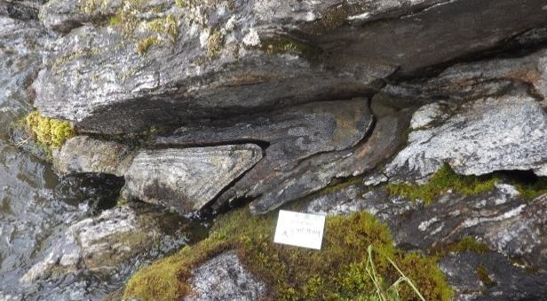
8 Bedrock mapping: Supracrustal and Associated Rocks Form rafts, xenoliths and/or slivers highly attenuated mostly mafic and intermediate volcanic rocks Mafic volcanic rock Intermediate volcanic rock

9 Bedrock mapping: Supracrustal and Associated Rocks Form rafts, xenoliths and/or slivers highly attenuated mostly mafic and intermediate volcanic rocks mafic xenoliths
10 Bedrock mapping: Supracrustal and Associated Rocks Minor sedimentary rocks and felsic volcanic Associated plutonic rocks - gabbro Pelite
11 Bedrock mapping: Supracrustal and Associated Rocks Minor sedimentary rocks and felsic volcanic Associated plutonic rocks - gabbro Pelite Migmatitic gabbro


12 Bedrock mapping: Supracrustal and Associated Rocks Minor sedimentary rocks and felsic volcanic Associated plutonic rocks - gabbro Pelite Migmatitic gabbro Felsic volcanic rock


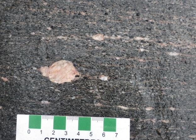
13 Bedrock mapping: Orthogneisses Main unit: felsic to intermediate pluton Dioritic to granodioritic, minor tonalite, quartz diorite, and quartz monzodiorite Gneissic diorite-granodiorite Stromatic migmatite

14 Bedrock mapping: Orthogneisses Main unit: felsic to intermediate pluton Dioritic to granodioritic, minor tonalite, quartz diorite, and quartz monzodiorite Homogeneous quartz diorite-diorite

15 Bedrock mapping: Late intrusive rocks Pegmatite and aplite dikes Granitic veinlets


16 Bedrock mapping: Late intrusive rocks Pegmatite and aplite dikes Pegmatite dikes Graphic texture in pegmatite

17 Bedrock mapping: Late intrusive rocks Anatectic granitic intrusions Ultramafic rocks Leucogranite

18 Bedrock mapping: Late intrusive rocks Anatectic granitic intrusions Ultramafic rocks Diatexitic granite

19 Bedrock mapping: Late intrusive rocks Anatectic granitic intrusions Ultramafic rocks Ultramafic intrusive rock


20 Metamorphism Upper amphibolite facies Partial melt No sillimanite or kyanite in the sediments Garnet porphyroblasts in leucogabbro Net-textured migmatite
21 Structure West varies relative to the east Deformation events: A D1 S1 D2 S2/F2 D3? D4? B

22 Structure West varies relative to the east Deformation events: D1 S1 D2 S2/F2 D3? D4?


23 Structure
24 Structure


25 Structure - west


26 Regional Structure Cross section - F3 and F4 differ from regional? - Transects anticlinorium hinge and Tabbernor Fault A B
27 Gold Economic considerations Map area located ~30 km NE of Seabee Gold Mine not many quartz veins documented VMS-type some gossanous sulphide rich outcrops


28 Economic considerations RMo Gossanous and magnetic outcrop southwest of White Lake B.Sc. Thesis Jared Squire Garnet, magnetite, hornblende and anthophyllite and/or cummingtonite mineralization
.")
29 Economic considerations SV Currently staked by Eagle Plains Resources Ltd (100%) In 2000, Leader Mining and Pine Channel Gold Inc completed reconnaissance geological mapping and prospecting of the southeast shore of Redhill Lake (AF 63M ). Assays yielded elevated Zn, Co, Cu, and Ni Samples were taken from this location SMDI #2745 located 1km+ NE
.")
30 Economic considerations SV Currently staked by Eagle Plains Resources Ltd (100%) In 2000, Leader Mining and Pine Channel Gold Inc completed reconnaissance geological mapping and prospecting of the southeast shore of Redhill Lake (AF 63M ). Assays yielded elevated Zn, Co, Cu, and Ni Samples were taken from this location SMDI #2745 located 1km+ NE
31 Economic considerations: SMDI #0400 U and Th Originally identified by W.G.Q. Johnston while mapping the area for the Saskatchewan Geological Survey in 1974 UTM E UTM N K (%) U (ppm) Th (ppm) TCPS SMDI # DD SV
32 Conclusions Same rock types, but different structural characteristics on either side of the Tabbernor Fault Lack of targeted exploration in the area Potential for VMS-type alteration/deposits Late radioactive granites/pegmatites
33 Acknowledgements Jr. Assistants: Nicholas Wicharuk, Jared Squire, Renee Larsen, and Kirsten Cunningham Colleagues at Saskatchewan Geological Survey

34
New geologic mapping + and associated economic potential on northern Hall Peninsula, Baffin Island, Nunavut
 New geologic mapping + and associated economic potential on northern Hall Peninsula, Baffin Island, Nunavut Holly Steenkamp, M.Sc. Regional Mapping Geoscientist David Mate, M.Sc. Chief Geologist November
Figure GS-25-1: General geology and domain subdivisions in northwestern Superior Province. 155
 GS-25 ASSEAN LAKE ANCIENT CRUST: AN UPDATE by M.T. Corkery, Ch.O. Böhm 1 and L.M Heaman 1 Corkery, M.T., Böhm, Ch.O. and Heaman, L.M. 2000: Assean Lake ancient crust: an update; in Report of Activities
APPENDIX 2 Table 2. Sample descriptions
 Table 2. descriptions 225 Felsic gneiss, fine-grained and very light-gray. From the upper part of the lower of the two layers, which connect. 226 Amphibolite, even-grained, fine-grained, medium-gray, little
Overview of 2016 regional bedrock mapping in the Tehery-Wager area, northwestern Hudson Bay, Nunavut
 Overview of 2016 regional bedrock mapping in the Tehery-Wager area, northwestern Hudson Bay, Nunavut Photo: Baker Lake, Nunavut Holly M. Steenkamp*, Canada-Nunavut Geoscience Office Université Laval Natasha
Pelican Narrows Project - Update
 Pelican Narrows Project - Update R. Maxeiner and N. Rayner Objective of Pelican Narrows project Overview of previously completed geochronology and regional geology Quick review of geology of the Kakinagimak
First Year assessment Report on Prospecting and Rock sampling, King George property, License M NTS 12A/05 Newfoundland and Labrador.
 First Year assessment Report on Prospecting and Rock sampling, King George property, License 016679M NTS 12A/05 Newfoundland and Labrador. Submitted by Shawn Rose For Shawn Rose January 2011 Work year
Appendix 11. Geology. of the. I60 area
 Appendix 11 Geology of the I60 area 1. Locality The locality of the I60 area is as follows; Northwestern corner; UTM_EW 530513, UTM_NS 7345741 Southwestern corner; UTM_EW 530418, UTM_NS 7301454 Northeastern
BLURTON CREEK NICKEL PROPERTY. (Minfile # 082LNW-039)
") 5489153 BLURTON CREEK NICKEL PROPERTY (Minfile # 082LNW-039) Mara Lake Area / Salmon Arm B.C NTS - 82L-11 (UTM 83/Z10, 357690E, 5614220N) Prepared by: Jim Cuttle, B.Sc., P.Geo. 86 Cloudburst Road Whistler,
5489153 BLURTON CREEK NICKEL PROPERTY (Minfile # 082LNW-039) Mara Lake Area / Salmon Arm B.C NTS - 82L-11 (UTM 83/Z10, 357690E, 5614220N) Prepared by: Jim Cuttle, B.Sc., P.Geo. 86 Cloudburst Road Whistler,
New U-Pb SHRIMP and Sm-Nd Isotopic Results for the Bassett Lake Leucogabbro, La Ronge Domain, Reindeer Zone
 New U-Pb SHRIMP and Sm-Nd Isotopic Results for the Bassett Lake Leucogabbro, La Ronge Domain, Reindeer Zone Ralf O. Maxeiner 1, Nicole Rayner 2 and Robert A. Creaser 3 Information from this publication
Mist Mis y Lake y Lak Mapping Progr ogr
 Far North Geomapping Initiative: Preliminary Results From Geological Mapping in the Misty Lake Area, Northwestern Manitoba Paul Kremer, Chris Couëslan, Anders Carlson (MGS) Nicole Rayner (GSC) Misty Lake
GS-16. Summary. Introduction
 GS-16 Archean and Paleoproterozoic geology of the northwestern Split Lake Block, Superior Province, Manitoba (parts of NTS 54D4, 5, 6 and 64A1) by R.P. Hartlaub 1, C.O. Böhm, Y.D. Kuiper 2, M.S. Bowerman
IMSG Post-conference Field Guide
 IMSG 2017 - Post-conference Field Guide Jérémie Lehmann, Marlina Elburg and Trishya Owen-Smith The purpose of this short field excursion on Wednesday 18 January is to show a variety of rocks that make
A Geological Transect Across the Southwestern Peter Lake Domain, Saskatchewan
 A Geological Transect Across the Southwestern Peter Lake Domain, Saskatchewan Ralf O. Maxeiner and Rebecca Hunter 1 Maxeiner, R.O. and Hunter, R. (2002): A geological transect across the southwestern Peter
IVANHOE DISCOVERS IMPORTANT NEW GOLD-COPPER PORPHYRY DISTRICT IN SOUTHERN MONGOLIA NEW PORPHYRY DISTRICT NOW NAMED BRONZE FOX
 November 29, 2004 IVANHOE DISCOVERS IMPORTANT NEW GOLD-COPPER PORPHYRY DISTRICT IN SOUTHERN MONGOLIA NEW PORPHYRY DISTRICT NOW NAMED BRONZE FOX ULAANBAATAR, MONGOLIA Ivanhoe Mines Chairman Robert Friedland
Precambrian rocks of Red River Wheeler Peak area, New Mexico
 Precambrian rocks of Red River Wheeler Peak area, New Mexico By K. C. Condie Disscussion INTRODUCTION This map covers an area bounded by Cabresto Creek drainage (north), Lucero Canyon (south), the escarpment
Igneous Rock Classification, Processes and Identification Physical Geology GEOL 100
 Igneous Rock Classification, Processes and Identification Physical Geology GEOL 100 Ray Rector - Instructor Major Concepts 1) Igneous rocks form directly from the crystallization of a magma or lava 2)
GS-17. Summary. Previous work. Regional setting. Introduction. Geology
 GS-17 Geology, structure and mineralization of the Ore Fault property, Bird River greenstone belt, southeastern Manitoba (parts of NTS 52L5NE and 52L6NW) by L.A. Murphy 1 and P. Theyer Murphy, L.A. and
Golden Cross Resources
 Golden Cross Resources Labrador Uranium Joint Venture with Altius Resources Update - November 2007 Labrador Uranium - Canada LABRADOR URANIUM PROPERTIES Golden Cross Resources signed an agreement with
GEOLOGY AND GEOCHRONOLOGY OF THE ISLAND LAKE GREENSTONE BELT, NORTHWESTERN SUPERIOR PROVINCE by J. Parks 1, S. Lin 1, M.T. Corkery and D.W.
 GS-17 GEOLOGY AND GEOCHRONOLOGY OF THE ISLAND LAKE GREENSTONE BELT, NORTHWESTERN SUPERIOR PROVINCE by J. Parks 1, S. Lin 1, M.T. Corkery and D.W. Davis 2 Parks, J., Lin, S., Corkery, M.T. and Davis, D.W.
CHAPTER ROCK WERE FORMED
 HOW CHAPTER 3 ROCK WERE FORMED 1 I. Modern geology- 1795 A. James Hutton- 1. uniformitarianism- "the present is the key to the past" a. b. the geologic processes now at work were also active in the past
Ralf O. Maxeiner and Kate MacLachlan 1
 Preliminary Bedrock Geology of the Eastern Nemeiben Lake Area in the Vicinity of the Elizabeth Lake Cu Deposit and the Dunlop Cu-Ni Deposit, Western Glennie Domain (parts of NTS 73P/03, /06, and /07) Ralf
Chapter 4 Rocks & Igneous Rocks
 Chapter 4 Rocks & Igneous Rocks Rock Definition A naturally occurring consolidated mixture of one or more minerals e.g, marble, granite, sandstone, limestone Rock Definition Must naturally occur in nature,
Bedrock geology of the Northern Indian Lake area, Manitoba (parts of NTS 64H3, 5, 6) by P.D. Kremer and T. Martins
 by P.D. Kremer and T. Martins") GS-11 Bedrock geology of the Northern Indian area, Manitoba (parts of NTS H3, 5, ) by P.D. Kremer and T. Martins Kremer, P.D. and Martins, T. 201: Bedrock geology of the Northern Indian area, Manitoba
GS-11 Bedrock geology of the Northern Indian area, Manitoba (parts of NTS H3, 5, ) by P.D. Kremer and T. Martins Kremer, P.D. and Martins, T. 201: Bedrock geology of the Northern Indian area, Manitoba
A Rock is A group of minerals that have been put together in several different ways.
 A Rock is A group of minerals that have been put together in several different ways. Depending on how they are put together, rocks are classified as: 1. Sedimentary 2. Igneous 3. Metamorphic Sedimentary
42. A study of intergrowth textures and their possible origins in the Alvand plutonic complex, Hamadan, Iran
 1 ISSN 1526-5757 42. A study of intergrowth textures and their possible origins in the Alvand plutonic complex, Hamadan, Iran Abstract Ali A. Sepahi and Lorence G. Collins April 5, 2002 Various types of
Gossan s Industrial Mineral Opportunities in Manitoba
 Gossan s Industrial Mineral Opportunities in Manitoba Presentation to: Gossan Resources Limited James Bamburak, M.Sc., P.Geo. July 2003 Manitoba Industry, Trade and Mines Industrial Mineral Opportunities
VECTORING VOLCANOGENIC MASSIVE SULPHIDE MINERALIZATION AT THE RAINDROP ZONE, SNOW LAKE (NTS 63K16), MANITOBA by G.H. Gale
, MANITOBA by G.H. Gale") GS-8 VECTORING VOLCANOGENIC MASSIVE SULPHIDE MINERALIZATION AT THE RAINDROP ZONE, SNOW LAKE (NTS 63K16), MANITOBA by G.H. Gale Gale, G.H. 2002: Vectoring volcanogenic massive sulphide mineralization at
GS-8 VECTORING VOLCANOGENIC MASSIVE SULPHIDE MINERALIZATION AT THE RAINDROP ZONE, SNOW LAKE (NTS 63K16), MANITOBA by G.H. Gale Gale, G.H. 2002: Vectoring volcanogenic massive sulphide mineralization at
Name Class Date STUDY GUIDE FOR CONTENT MASTERY
 Igneous Rocks What are igneous rocks? In your textbook, read about the nature of igneous rocks. Use each of the terms below just once to complete the following statements. extrusive igneous rock intrusive
for the Greenwood Mining Division, B.C. NTS 82E/7W 29' W, Longitude 118' 53' N Prepared by D. Dylan Watt, B.Sc.
 for the FltE NO: u VOLT 1, VOLT 2, VOLT 3, & VOLT 4 CLAIMS Greenwood Mining Division, B.C. NTS 82E/7W Latitude 49' 29' W, Longitude 118' 53' N Prepared by D. Dylan Watt, B.Sc. #309-1996 Trutch Street Vancouver,
for the Greenwood Mining Division, B.C. NTS 82E/7W Latitude 49' 27' W, Longitude 118' 5 Prepared by a= D. Dylan Watt, B.Sc.
 t. b LOGnO: 37~ -08 m. ACTIO#: for the AMP AMP 2 AMP 3 t AMP 4 CLAIMS Greenwood Mining Division, B.C. NTS 82E/7W Latitude 49' 27' W, Longitude 8' 5 %E c,w zc *& a w Prepared by a= -4c. D. Dylan Watt, B.Sc.
Total Magnetic Field and VLF Surveys on the Swayze Property. Claim Swayze Township. Porcupine Mining Division
 1 January, 016 NTS: 041 O 15 Total Magnetic Field and VLF Surveys on the Swayze Property Claim 475471 Swayze Township Porcupine Mining Division 380850E, 599450N UTM Z17N NAD83 Report Prepared for: 540
GEOLOGICAL INVESTIGATION IN THE ISLAND LAKE GREENSTONE BELT, NORTHWESTERN SUPERIOR PROVINCE, MANITOBA (PARTS OF NTS 53E/15 & 16) GS-18
 GS-18") GS-18 GEOLOGICAL INVESTIGATION IN THE ISLAND LAKE GREENSTONE BELT, NORTHWESTERN SUPERIOR PROVINCE, MANITOBA (PARTS OF NTS 53E/15 & 16) by S. Lin, H.D.M. Cameron, E.C. Syme and F. Corfu 1 Lin, S., Cameron,
GS-18 GEOLOGICAL INVESTIGATION IN THE ISLAND LAKE GREENSTONE BELT, NORTHWESTERN SUPERIOR PROVINCE, MANITOBA (PARTS OF NTS 53E/15 & 16) by S. Lin, H.D.M. Cameron, E.C. Syme and F. Corfu 1 Lin, S., Cameron,
3. GEOLOGY. 3.1 Introduction. 3.2 Results and Discussion Regional Geology Surficial Geology Mine Study Area
 3. GEOLOGY 3.1 Introduction This chapter discusses the baseline study of the geology and mineralization characteristics of the mine study area. The study consolidates existing geological data and exploration
To get you thinking What natural process is responsible for the appearance of these rocks? Rocks and the Rock Cycle
 To get you thinking What natural process is responsible for the appearance of these rocks? Rocks and the Rock Cycle Bell Ringer Name the 3 types of rock. Is one type of rock able to change into a different
Nachicapau Zn-Cu project THE NEXT MAJOR DISCOVERER IN QUEBEC
 Nachicapau Zn-Cu project THE NEXT MAJOR DISCOVERER IN QUEBEC Nachicapau Project - Location Willbob & Pallas Projects Kuujjuaq Located about 150km south of Kuujjuaq, the closest community (has a port) 215
Geochemical exploration on the Tareek Darreh Gold deposit, north of Torbat-e Jaam, east Iran
 Geochemical exploration on the Tareek Darreh Gold deposit, north of Torbat-e Jaam, east Iran Kourosh Shabani, M.Sc. Student of Economic Geology, Islamic Azad University, Science and Research Branch, Tehran,
CHAPTER ROCK WERE FORMED
 HOW CHAPTER 5 ROCK WERE FORMED 1 I. Modern geology- 1795 A. James Hutton- 1. uniformitarianism- "the present is the key to the past" a. b. the geologic processes now at work were also active in the past
PROSPECTORS ASSISTANCE PROGRAM MINISTRY OF ENERGY AND MINES
 BRITISH COLUMBIA PROSPECTORS ASSISTANCE PROGRAM MINISTRY OF ENERGY AND MINES GEOLOGICAL SURVEY BRANCH PROGRAM YEAR: 1999/2000 REPORT #: PAP 99-l 6 NAME: KIM ANSCHETZ PROSPECTORS TlEPORT on the 99 LOUIS
SEPTEMBER QUARTERLY REPORT
 SEPTEMBER QUARTERLY REPORT Resource Mining Corporation Limited ( RMC ) For the period ended 30 th September 2011 HIGHLIGHTS: Resource Mining Corporation Limited ABN: 97 008 045 083 702 Murray Street West
GS Manitoba Geological Survey
 GS2017-2 In Brief: Scheelite mineralization was investigated as a potential analog to the Monument Bay Au-W deposit A crustal-scale fault defines the contact between supracrustal and plutonic rocks Disseminated
2013 GEOLOGICAL ASSESSMENT REPORT SHERIDAN HILL PROPERTY
 2013 GEOLOGICAL ASSESSMENT REPORT ON THE SHERIDAN HILL PROPERTY NEW WESTMINSTER MINING DIVISION BRITISH COLUMBIA NTS 092G07 49 16 31 NORTH LATITUDE, 122 39 48 WEST LONGITUDE PREPARED FOR Sheridan Hill
POTENTIAL FOR SIGNIFICANT UNDISCOVERED METALLIC ORE DEPOSITS IN MAINE. John F. Slack U.S. Geological Survey (Emeritus), Farmington, ME 04938
, Farmington, ME 04938") POTENTIAL FOR SIGNIFICANT UNDISCOVERED METALLIC ORE DEPOSITS IN MAINE John F. Slack U.S. Geological Survey (Emeritus), Farmington, ME 098 Geological Society of Maine, Augusta, 7 November 207 Outline Important
POTENTIAL FOR SIGNIFICANT UNDISCOVERED METALLIC ORE DEPOSITS IN MAINE John F. Slack U.S. Geological Survey (Emeritus), Farmington, ME 098 Geological Society of Maine, Augusta, 7 November 207 Outline Important
Igneous and Metamorphic Rock Forming Minerals. Department of Geology Mr. Victor Tibane SGM 210_2013
 Igneous and Metamorphic Rock Forming Minerals Department of Geology Mr. Victor Tibane 1 SGM 210_2013 Grotzinger Jordan Understanding Earth Sixth Edition Chapter 4: IGNEOUS ROCKS Solids from Melts 2011
New gold discovery in the Paleoproterozoic Mauken greenstone belt
 New gold discovery in the Paleoproterozoic Mauken greenstone belt Mauken greenstone belt The Paleoproterozoic Mauken greenstone belt is situated in an unexplored and untested terrain in Northern Norway.
The MAPLE BAY PROJECT Copper Silver - Gold
 The MAPLE BAY PROJECT Copper Silver - Gold Good grade and tonnage potential within close proximity to Tidewater The Maple Bay Copper Silver Gold Project covers highly favourable geological host rocks of
Tasiilaq a region unfolds and new findings
 Tasiilaq a region unfolds and new findings Regional overview with emphasize on new understanding and mineral potential Bo M. Stensgaard & Jochen Kolb GEUS & MMR SEGMENT participants Greenland Exploration
We are committed to providing accessible customer service. If you need accessible formats or communications supports, please contact us.
 We are committed to providing accessible customer service. If you need accessible formats or communications supports, please contact us. Nous tenons à améliorer l accessibilité des services à la clientèle.
RR#7 - Multiple Choice
 1. Which mineral is mined for its iron content? 1) hematite 2) fluorite 3) galena 4) talc 2. Which rock is composed of the mineral halite that formed when seawater evaporated? 1) limestone 2) dolostone
For personal use only
 27 October 2011 QUARTERLY ACTIVITIES REPORT for the period ended 30 September 2011 Three new projects were acquired recently to provide Power Resources with a Western Australian focus. The portfolio comprises
it AUSIMM COBAR MINING SEMINAR
 Straits Resources Limited it AUSIMM COBAR MINING SEMINAR Brownfields Exploration at Girilambone: Understanding the Mineralised Systems August 2010 Phil Shields / Phil Jones LOCATION TRITTON OPERATIONS
Some Slides Lack Permission for Reproduction. These Slides must be deleted before posting as html or pdf! Metamorphic Rocks. GEOL 101 Lecture
 Some Slides Lack Permission for Reproduction. These Slides must be deleted before posting as html or pdf! Metamorphic Rocks GEOL 101 Lecture 9 2006 JS Kite WVU What is story behind this rock? Test 1 Results
Report of Activities 2003 Published by: Manitoba Industry, Economic Development and Mines Manitoba Geological Survey, 2003.
 Report of Activities 2003 Published by: Manitoba Industry, Economic Development and Mines Manitoba Geological Survey, 2003. ERRATA: The publisher/department name in the bibliographic reference cited immediately
ASSESSMENT REPORT PROSPECTING PROGRAM ION/DIRTY JACK PROPERTY NELSON MINING DIVISION N.T.S. MAP SHEET 82F.023 UTM COORDINATES N E
 ASSESSMENT REPORT PROSPECTING PROGRAM ION/DIRTY JACK PROPERTY NELSON MINING DIVISION N.T.S. MAP SHEET 82F.023 UTM COORDINATES 5454800N - 0455235E Work Performed Summer 2007 OWNER >* ' Tom Kennedy >8 404-22
Queensland Mining Corporation Limited
 Queensland Mining Corporation Limited ABN 61 109 962 469 ASX Release 29 th July 2011 Drilling Commenced at Duck Creek Copper-Gold Project, Cloncurry, North-west Queensland Highlights RC drilling has commenced
twd$ yqsi+hca
 -t@~cl--t,i twd$ yqsi+hca C ASSESSMENT REPORT ON THE OR0 1-5 CLAIMS NEAR GOLDBRIDGE, B.C. Lillooet Mining Division N.T.S. 92 J / 15 W Long. 122 51.5 W. Lat. 50 47.5 N. Owned by Levon Resources Ltd. Optioned
The 3 types of rocks:
 Igneous Rocks and Intrusive Igneous Activity The 3 types of rocks:! Sedimentary! Igneous! Metamorphic Marble 1 10/7/15 SEDIMENTARY ROCKS Come from rocks sediments (rock fragments, sand, silt, etc.) Fossils
Name Class Date STUDY GUIDE FOR CONTENT MASTERY
 Igneous Rocks What are igneous rocks? In your textbook, read about the nature of igneous rocks. Use each of the terms below just once to complete the following statements. extrusive igneous rock intrusive
The Geology of Sebago Lake State Park
 Maine Geologic Facts and Localities September, 2002 43 55 17.46 N, 70 34 13.07 W Text by Robert Johnston, Department of Agriculture, Conservation & Forestry 1 Map by Robert Johnston Introduction Sebago
Archean and Early Proterozoic Field Relationships in the Careen lake Area of the Western Granulite Domain 1
 Archean and Early Proterozoic Field Relationships in the Careen lake Area of the Western Granulite Domain 1 C.H. Crocker2 and K.D. Collerson 2 Crocker, C.H. a_nd Colle~so~, K.D. (1988): Archean and Early
Quarterly Report for the period ended 31 March 2006
 96 Parry Street PERTH WA 6000 PO Box 8178 PERTH BUSINESS CENTRE WA 6849 Ph: (08) 9328 9292 Fax: (08) 9227 6011 Email: info@nsrltd.com, Web: www.nsrltd.com Quarterly Report for the period ended 31 March
Geology 1 st Semester Exam YSBAT
 1. What is the role of a geologist? Geology 1 st Semester Exam YSBAT 2016-2017 2. Earth is subdivided into three main layers based on what? 3. What features do you find at divergent boundaries? 4. Rock
State Metallic Minerals Lease Sale Minnesota s Vermilion Gold District
 State Metallic Minerals Lease Sale Minnesota s Vermilion Gold District State Metallic Minerals Lease Sale Notice of Intent Scale 1:100,000 State Metallic Minerals Lease Sale This portion of the lease sale
GEOLOGY AND LITHOGEOCHEMISTRY OF THE CHILKO-TASEKO LAKES AREA* BY G.
 B Ministry of Energy, Mines and Petroleum Resources GEOLOGICAL BRANCH MINERAL RESOURCES DIVISION NOTES TO ACCOMPANY OPEN FILE - GEOLOGY AND LITHOGEOCHEMISTRY OF THE CHILKO-TASEKO LAKES AREA* BY G. P. McLAREN
Plate tectonics, rock cycle
 Dikes, Antarctica Rock Cycle Plate tectonics, rock cycle The Rock Cycle A rock is a naturally formed, consolidated material usually composed of grains of one or more minerals The rock cycle shows how one
EXISTING GEOLOGICAL INFORMATION
 CHAPER 3 EXISTING GEOLOGICAL INFORMATION 3-1 General Geology of the Surrounding Area (1) General geology and ore deposits in Mongolia Geographically, Mongolia is a country located between Russia to the
Acquisition of Kilfoyle Project, Northern Territory
 ASX Announcement 31 May 2018 Level 1, 135 Fullarton Road Rose Park, SA 5067 Australia Telephone +61 (0) 8 8364 3188 Facsimile +61 (0) 8 8364 4288 info@pnxmetals.com.au www.pnxmetals.com.au Acquisition
Origin and Kinematic History of Highly Strained Gneisses in the Jan Lake East Area
 Origin and Kinematic History of Highly Strained Gneisses in the Jan Lake East Area Shi Rupan 1 and J.F. Lewry 1 Shi, R. and Lewry, J.F. (1991 ): Origin and kinematic history of highly strained gneisses
New insights on the THO-Superior boundary: Tectonic and metallogenic implications
 New insights on the THO-Superior boundary: Tectonic and metallogenic implications John Percival, GSC Nicole Rayner, GSC Herman Zwanzig, MGS Linda Murphy, MGS Joe Whalen, GSC Martha Growdon, Indiana U.
The Wathaman Batholith and Its Relation to the Peter Lake Domain: Insights from Recent Mapping along the Reindeer Lake Transect, Trans-Hudson Orogen
 The Wathaman Batholith and Its Relation to the Peter Lake Domain: Insights from Recent Mapping along the Reindeer Lake Transect, Trans-Hudson Orogen D. Corrigan 1, T G. MacHattie 2, and J. Chakungal 3
Uranium Exploration in North West Manitoba
 CanAlaska Uranium Ltd. Uranium Exploration in North West Manitoba Ross Polutnik K. Schimann, R. Duff, S. Napier Manitoba Mining and Minerals Convention: Nov 15-17, 2012 1 NW Manitoba Project: Outline Project
IGNEOUS ROCKS. SECTION 5.1 What are igneous rocks?
 Date Period Name IGNEOUS ROCKS SECTION.1 What are igneous rocks? In your textbook, read about the nature of igneous rocks. Use each of the terms below just once to complete the following statements. basaltic
We are committed to providing accessible customer service. If you need accessible formats or communications supports, please contact us.
 We are committed to providing accessible customer service. If you need accessible formats or communications supports, please contact us. Nous tenons à améliorer l accessibilité des services à la clientèle.
BCGold Corp. Discovery Driven
 BCGold Corp. Discovery Driven Sickle-Sofia Property Copper-Gold Porphyry Discovery in the Toodoggone Camp! Cautionary Statement This presentation does not constitute an offer to sell or solicitation of
GEOLOGY AND METALLOGENY OF MELVILLE PENINSULA: AN UPDATE ON RECENT ACTIVITIES OF THE GEM-MINERALS PROJECT
 GEOLOGY AND METALLOGENY OF MELVILLE PENINSULA: AN UPDATE ON RECENT ACTIVITIES OF THE GEM-MINERALS PROJECT David Corrigan 1 and Tommy Tremblay 2 (1) Geological Survey of Canada, Ottawa, ON (2) Canada-Nunavut
RESULTS OF OPERATIONS Semi Annual Exploration Report BANLUNG EXPLORATION LICENSE, CAMBODIA FOR THE PERIOD 2015:06:30 TO 2015:12:31
 RESULTS OF OPERATIONS BANLUNG EXPLORATION LICENSE, CAMBODIA FOR THE PERIOD 2015:06:30 TO 2015:12:31 Introduction Work over the period has included the completion of a detailed induced polarization geophysical
GLY 155 Introduction to Physical Geology, W. Altermann. Grotzinger Jordan. Understanding Earth. Sixth Edition
 Grotzinger Jordan Understanding Earth Sixth Edition Chapter 4: IGNEOUS ROCKS Solids from Melts 2011 by W. H. Freeman and Company Chapter 4: Igneous Rocks: Solids from Melts 1 About Igneous Rocks Igneous
We are committed to providing accessible customer service. If you need accessible formats or communications supports, please contact us.
 We are committed to providing accessible customer service. If you need accessible formats or communications supports, please contact us. Nous tenons à améliorer l accessibilité des services à la clientèle.
Drill locations for the 2015 program are highlighted in the geology map below.
 2015 Exploration Program The exploration program plan at KSM for 2015 was designed to improve the understanding of block cave targets and support engineering/environmental aspects of development scenarios.
Lands Parcels in IOL CO-20
 Lands Parcels in IOL CO-20 1 CO-20 The Izok Corridor Lupin - multi-million ounce past gold production (3.6 million oz of gold at average grade of 9.3 g/t Au) Approximately 1 million ounces of undeveloped
Compilation Report Hawke Hill South. Licence No M NTS 01N/06. Newfoundland and Labrador. Submitted by Gordon E. Cooper and Kevin P.
 Compilation Report 2010 Hawke Hill South Licence No. 017282M NTS 01N/06 Newfoundland and Labrador Submitted by Gordon E. Cooper and Kevin P. Ryan For Kevin P. Ryan (Licence holder) January, 2011 Work Year:
Mineral Potential of the Blue Lake Area
 Mineral Potential of the Blue Lake Area Prepared by Gregory P. Streveler and Daniel M. Mann Icy Strait Environmental Services Box 94 Gustavus, AK 99826 for The City of Sitka 6/22/09 INTRODUCTION The City
A Field Guide to Naming Migmatites and Their Textures, with Saskatchewan Examples
 A Field Guide to Naming Migmatites and Their Textures, with Saskatchewan Examples Ralf O. Maxeiner 1, Ken Ashton 1, Colin D. Card 1, Ryan M. Morelli 1 and Bernadette Knox 2 Information from this publication
We are committed to providing accessible customer service. If you need accessible formats or communications supports, please contact us.
 We are committed to providing accessible customer service. If you need accessible formats or communications supports, please contact us. Nous tenons à améliorer l accessibilité des services à la clientèle.
Geological investigations in the Manasan Falls area, Thompson Nickel Belt, Manitoba (part of NTS 63P12) by C.G. Couëslan
 by C.G. Couëslan") GS-9 Geological investigations in the Manasan Falls area, Thompson Nickel Belt, Manitoba (part of NTS 63P2) by C.G. Couëslan Couëslan, C.G. 20: Geological investigations in the Manasan Falls area, Thompson
GS-9 Geological investigations in the Manasan Falls area, Thompson Nickel Belt, Manitoba (part of NTS 63P2) by C.G. Couëslan Couëslan, C.G. 20: Geological investigations in the Manasan Falls area, Thompson
Geology and Metamorphic Petrology of Variably Altered Volcanic Rocks in the Southern Reindeer Lake Area, Northern Saskatchewan
 Geology and Metamorphic Petrology of Variably Altered Volcanic Rocks in the Southern Reindeer Lake Area, Northern Saskatchewan Donald M Wright 1, Kevin M Ansdell 1, David Corrigan 2, and Ralf 0. Maxeiner
Lithogeochemistry of Pegmatites at Broken Hill: An Exploration Vector to Mineralisation
 Lithogeochemistry of Pegmatites at Broken Hill: An Exploration Vector to Mineralisation G. M. Coianiz* C. E. Torrey Exploris Pty Ltd Silver City Minerals Ltd 8 Gordon Street 80 Chandos Street Lismore NSW
Big Island Field Trip
 Big Island Field Trip Space Still Available Group Airline Tickets May be available if enough people sign on If interested send email to Greg Ravizza Planning Meeting Next Week Will
Practice Test Rocks and Minerals. Name. Page 1
 Name Practice Test Rocks and Minerals 1. Which rock would be the best source of the mineral garnet? A) basalt B) limestone C) schist D) slate 2. Which mineral is mined for its iron content? A) hematite
ASX Announcement. 28 January Drill results indicate large Porphyry Copper Gold System at Peenam
 ASX Announcement 28 January 2010 Drill results indicate large Porphyry Copper Gold System at Peenam Highlights: 270 metres of visible copper (gold) mineralisation in first diamond core hole at Peenam Prospect
Beekeeper Property The Geology South of Mint Lake. Cariboo Mining Division
 Beekeeper Property The Geology South of Mint Lake NTS: 93A/6 Cariboo Mining Division Claims: Beekeeper 1 #I2055 Beekeeper 2 #3892 Beekeeper 3 #7895 Beekeeper 4 #8503 Latitude: Longitude: 52 degrees 24
Page 1. Name:
 Name: 1) What is the approximate density of a mineral with a mass of 262.2 grams that displaces 46 cubic centimeters of water? A) 6.1 g/cm 3 C) 1.8 g/cm 3 B) 5.7 g/cm 3 D) 12.2 g/cm 3 2) In which two Earth
EMORY PLACER CLAIM Yale Region New Westminster Mining Division
 EMORY PLACER CLAIM Yale Region New Westminster Mining Division EVENT # 4646011 TENURE # 608187 Tenure Name: Emory NTS Map 92H/11 Approximate Centre of Tenure 121 25 12 W Longitude 49 30 44 N Latitude Report
GS Report of Activities 2018
 GS2018-4 In Brief: Drillcore observation and geophysics define a new geological interpretation of the sub-phanerozoic basement southeast of Wekusko Lake Previously unrecognized mafic to felsic volcanic
Magmatic-Hydrothermal Gold Systems in the Archean of Northern Ontario, Canada: Examples of Syenite-Associated and Porphyry-Type Au-(Cu) Deposits
 Deposits") Magmatic-Hydrothermal Gold Systems in the Archean of Northern Ontario, Canada: Examples of Syenite-Associated and Porphyry-Type Au-(Cu) Deposits By Dr. Daniel J. Kontak Department of Earth Sciences Laurentian
Magmatic-Hydrothermal Gold Systems in the Archean of Northern Ontario, Canada: Examples of Syenite-Associated and Porphyry-Type Au-(Cu) Deposits By Dr. Daniel J. Kontak Department of Earth Sciences Laurentian
Gold Mineralization Potential in a Wabigoon Subprovince Granite-Greenstone Terrane, International Falls Area, Minnesota
 Gold Mineralization Potential in a Wabigoon Subprovince Granite-Greenstone Terrane, International Falls Area, Minnesota Manitoba Ontario Mn The State of Minnesota is located in the north-central portion
New Results and Ideas from the Rottenstone Domain Project
 New Results and Ideas from the Rottenstone Domain Project Kate MacLachlan, Nicole Rayner, Greg Dunning, and Chad Leugner 3 MacLachlan, K., Rayner, N., Dunning, G., and Leugner, C.(004) New results and
Mishi Lake Gold Property Mishibishu Lake Area, Wawa
 Mishi Lake Gold Property Mishibishu Lake Area, Wawa Location, Accessibility, Infrastructure and Local Resources The property is located 40 km west of Wawa, Ontario, in the Mishibishu Lake Area, Sault Ste.
Name Class Date. In your textbook, read about the nature of igneous rocks. Use each of the terms below just once to complete the following statements.
 CHAPTER 5 Igneous Rocks SECTION 5.1 What are igneous rocks? In your textbook, read about the nature of igneous rocks. Use each of the terms below just once to complete the following statements. basaltic
Prospectivity mapping for orogenic gold in South-East Greenland
 Prospectivity mapping for orogenic gold in South-East Greenland Björn H. Heincke & Bo Møller Stensgaard Presented by Kristine Thrane Geological Survey of Denmark and Greenland Danish Ministry of Climate,
Amboy Iron Mines, Bristol Mountains, San Bernardino County, California. Gregg Wilkerson 2017
 Amboy Iron Mines, Bristol Mountains, San Bernardino County, California Gregg Wilkerson 2017 Acknowledgement and Disclaimer The information in this paper is taken largely from published sources. I have