PRINCIPLES AND APPLICATIONS of OCEAN FEATURE NOMENCLATURE
|
|
|
- Jocelin Johnston
- 5 years ago
- Views:
Transcription


1 PRINCIPLES AND APPLICATIONS of OCEAN FEATURE NOMENCLATURE Michel HUET International Hydrographic Bureau MONACO
2 "Undersea feature" is a part of the ocean floor or seabed that has measurable relief or is delimited by relief (Guidelines for the Standardization of Undersea Feature Names, IHO-IOC Publication B-6, 2001) Generic name, e.g. seamount, canyon, fracture zone Proper name, e.g. Albert de Monaco, Challenger, Gambia, Gauss
3 Need for: An uniform policy for the handling of undersea feature names; Standardisation of undersea feature names; in order to achieve consistent geographic naming on nautical charts and bathymetric maps.
4 Undersea Feature Names Terms and Definitions (Nomenclature) 8th Internatinal Geographical Congress, 1904 IHO, 1924 IHO-IOC, 1981 IHO-IOC, 1988 IHO-IOC, 2001
5 GEBCO SUB-COMMITTEE ON UNDERSA FEATURE NAMES (SCUFN) Established in 1974 to oversee the standardization of seafloor topographic usage on GEBCO 5 th edition sheets Scope extended to nautical charts (small scale INT charts) and sheets/products of all International Bathymetric Chart (IBC) projects Nomenclature and Gazetteer Marine geology; Geomorphology; Marine history; Oceanic hydrography/bathymetry
6 SCUFN s Liaisons Advisory Committee on Undersea Features (ACUF), of the US BGN UN Group of Experts on Geographical Names (UNGEGN) The Sub-Committee shall maintain close liaison with the UN Group of Experts on Geographical Names and national authorities concerned with the naming of undersea features (SCUFN s Terms of Reference)
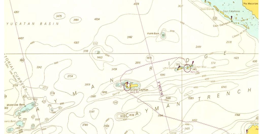
7 INT CHART
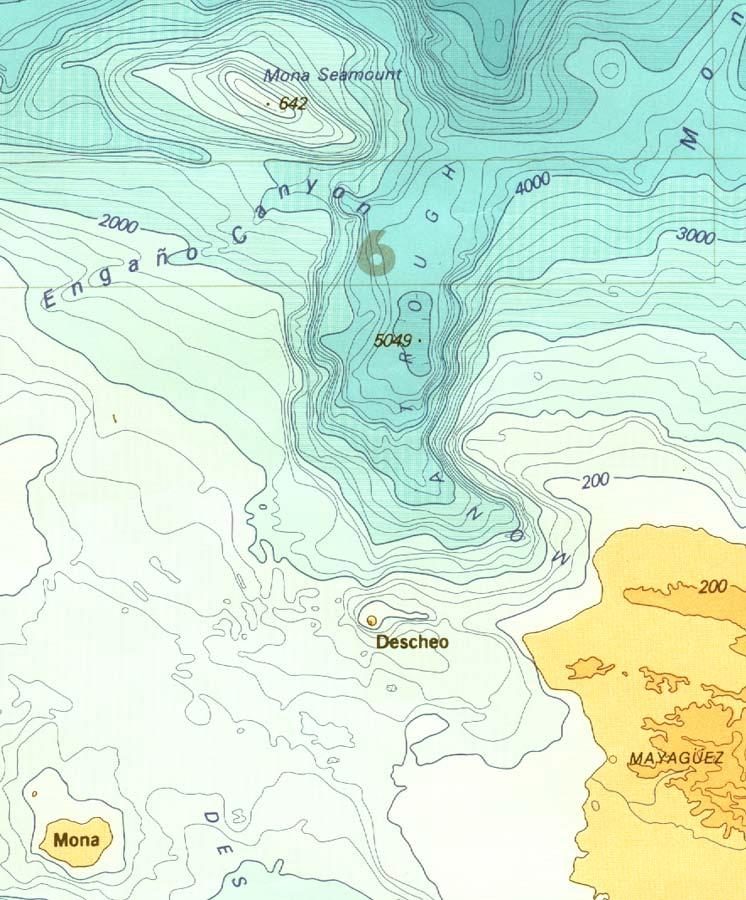
8 BATHYMETRIC MAP
9 NOMENCLATURE UNDERSEA FEATURE TERMS AND DEFINITIONS SLOPE The deepening sea floor out from the shelfedge to the upper limit of the continental rise, or the point where there is a general decrease in steepness.
10 Some rules GUIDELINES SCUFN work is limited to those features entirely or mainly (more than 50%) outside waters under the jurisdiction of states, i.e. outside territorial waters, usually limited to 12 miles from the straight baseline. When two names have been applied to the same feature, the older name generally should be accepted. When a single name has been applied to two different features, the feature named first generally should retain the name.
11 GUIDELINES Some rules (cont.) The first choice of a specific term, where feasible, should be one associated with a geographical feature; e.g.: Aleutian Ridge, Peru-Chile Trench. Specific terms for other features can be used to commemorate ships, expeditions or scientific institutes, or to honour the memory of famous persons. Names of living persons should be limited to those who have made an outstanding or fundamental contribution to ocean sciences.
12 GEBCO GAZETTEER Name: Feature: Position: Bob Fisher Ridge 43 45'S 'E to 36 00'S 'E to 41 30'S 'E to 40 00'S 'E to 38 00'S 'E Proposer: J. Sclater/A. Goodwillie, SIO, USA Date: 04/1998 Discoverer: Date: History: Named after Dr. Robert L. Fisher, SIO, the most active contributor to GEBCO over the years, currently through his recontouring of the whole of the greater Indian Ocean, from 10 W to 165 E and south to Antarctica, and also his erudite leadership as Chairman of GEBCO-SCUFN. Referenced: GEBCO 5.09 Accredited: SCUFN/13-06/1999
13 NOMENCLATURE and GUIDELINES for submission of names in IHO-IOC Publication B-6 «Standardisation of Undersea Feature Names» available from English/French and English/Spanish
14 SUBMISSION OF PROPOSALS Undersea Feature Name Proposal Form Available from GEBCO website Submit to Secretariat of SCUFN International Hydrographic Bureau
15 SUBMISSION OF PROPOSALS (Cont) Main Criterias Supporting bathymetric evidence Reason for choice of name Discovery facts: date, ship, position and depth accuracy
16 SCUFN RULES OF PROCEDURES Meetings once a year Work by correspondence between meetings Decisions by consensus, as far as possible Close collaboration with ACUF (of U.S. BGN)
17 GEBCO GAZETTEER Name: ALCOCK Feature: Rise Position: N E Proposer: Dr J.R. Curray, SIO, USA Date: 10/1993 Discoverer: IIOE Ships Date: 00/1960 History: A. Alcock (UK) made marine studies in the late 1800s. Author of "A Naturalist in Indian Seas", London, His name was suggested for "Seamounts" by Rodolfo, Referenced: GEBCO 5.05 Accredited: SCUFN/11-05/1995
18 GEBCO GAZETTEER Gazetteer database maintained at the IHB 3300 names (March 2003) Available from GEBCO website as an Excel file
19 SCUFN Secretariat: International Hydrographic Bureau 4 quai Antoine 1er, BP 445 MC98011 Monaco Cedex Principality of Monaco Tel.: Fax : pac@ihb.mc
THE INTERNATIONAL HYDROGRAPHIC ORGANIZATION AND ITS INVOLVEMENT WITH GEOGRAPHICAL PLACE NAMES
 International Hydrographie Review, Monaco, LXXV(1), March 1998 THE INTERNATIONAL HYDROGRAPHIC ORGANIZATION AND ITS INVOLVEMENT WITH GEOGRAPHICAL PLACE NAMES by Adam J. KERR' INTRODUCTION It may be useful
UNDERSEA FEATURE NAME PROPOSAL (See IHO-IOC Publication B-6 and NOTE overleaf)
") INTERNATIONAL HYDROGRAPHIC ORGANIZATION INTERGOVERNMENTAL OCEANOGRAPHIC COMMISSION (of UNESCO) Note: The boxes will expand as you fill the form. UNDERSEA FEATURE NAME PROPOSAL (See IHO-IOC Publication
INTERNATIONAL HYDROGRAPHIC ORGANIZATION INTERGOVERNMENTAL OCEANOGRAPHIC COMMISSION (of UNESCO) Note: The boxes will expand as you fill the form. UNDERSEA FEATURE NAME PROPOSAL (See IHO-IOC Publication
UNDERSEA FEATURE NAME PROPOSAL. Name Proposed: Kiminu Seamount. to Long.
 INTERNATIONAL HYDROGRAPHIC ORGANIZATION INTERNATIONAL OCEANOGRAPHIC COMMISSION (of UNESCO) UNDERSEA FEATURE NAME PROPOSAL Ocean or Sea: East Sea Name Proposed: Coordinates: A of midpoint or summit: Lat.
UNDERSEA FEATURE NAME PROPOSAL (See NOTE overleaf)
") INTERNATIONAL HYDROGRAPHIC ORGANIZATION INTERGOVERNMENTAL OCEANOGRAPHIC COMMISSION (of UNESCO) Note: The boxes will expand as you fill the form. UNDERSEA FEATURE NAME PROPOSAL (See NOTE overleaf) Name
INTERNATIONAL HYDROGRAPHIC ORGANIZATION INTERGOVERNMENTAL OCEANOGRAPHIC COMMISSION (of UNESCO) Note: The boxes will expand as you fill the form. UNDERSEA FEATURE NAME PROPOSAL (See NOTE overleaf) Name
STANDARDISATION OF MARITIME GEOGRAPHICAL NAMES: The Role of the International Hydrographic Organization
 STANDARDISATION OF MARITIME GEOGRAPHICAL NAMES: The Role of the International Hydrographic Organization Ing en chef Michel Huet International Hydrographic Bureau 4, quai Antoine 1 er MC 98011 - Monaco
UNDERSEA FEATURE NAME PROPOSAL (See IHO-IOC Publication B-6 and NOTE overleaf) S (centre) S S S
 S (centre) S S S") INTERNATIONAL HYDROGRAPHIC ORGANIZATION INTERGOVERNMENTAL OCEANOGRAPHIC COMMISSION (of UNESCO) Note: The boxes will expand as you fill the form. UNDERSEA FEATURE NAME PROPOSAL (See IHO-IOC Publication
INTERNATIONAL HYDROGRAPHIC ORGANIZATION INTERGOVERNMENTAL OCEANOGRAPHIC COMMISSION (of UNESCO) Note: The boxes will expand as you fill the form. UNDERSEA FEATURE NAME PROPOSAL (See IHO-IOC Publication
UNDERSEA FEATURE NAME PROPOSAL (Sea NOTE overleaf)
") INTERNATIONAL HYDROGRAPHIC ORGANIZATION INTERGOVERNMENTAL OCEANOGRAPHIC COMMISSION (of UNESCO) Note: The boxes will expand as you fill the form. UNDERSEA FEATURE NAME PROPOSAL (Sea NOTE overleaf) Name
INTERNATIONAL HYDROGRAPHIC ORGANIZATION INTERGOVERNMENTAL OCEANOGRAPHIC COMMISSION (of UNESCO) Note: The boxes will expand as you fill the form. UNDERSEA FEATURE NAME PROPOSAL (Sea NOTE overleaf) Name
UNDERSEA FEATURE NAME PROPOSAL (See IHO-IOC Publication B-6 and NOTE overleaf)
") INTERNATIONAL HYDROGRAPHIC ORGANIZATION INTERGOVERNMENTAL OCEANOGRAPHIC COMMISSION (of UNESCO) Note: The boxes will expand as you fill the form. UNDERSEA FEATURE NAME PROPOSAL (See IHO-IOC Publication
INTERNATIONAL HYDROGRAPHIC ORGANIZATION INTERGOVERNMENTAL OCEANOGRAPHIC COMMISSION (of UNESCO) Note: The boxes will expand as you fill the form. UNDERSEA FEATURE NAME PROPOSAL (See IHO-IOC Publication
Lawrence A. Lawver Ian W.D. Dalziel Robert Larter University of Texas at Austin, Institute for Geophysics British Antarctic Survey
 20 August 2012 Prof. Hans-Werner Schenke, Chairman GEBCO Sub-Committee on Undersea Feature Names (SCUFN) International Hydrographic Bureau (IHB) 4, Quai Antoine 1er B.P. 445 MC 98011 MONACO CEDEX Principality
Coordinates : A - of midpoint or summit : Lat., Long. } to. Description (kind of feature) : seachannel
 : seachannel") INTERNATIONAL HYDROGRAPHIC ORGANIZATION INTERGOVERNMENTAL OCEANOGRAPHIC COMMISSION (of UNESCO) IHO/IOC Form No. 1 UNDERSEA FEATURE NAME PROPOSAL (See NOTE overleaf) Ocean or Sea Japan Sea Name proposed
INTERNATIONAL HYDROGRAPHIC ORGANIZATION INTERGOVERNMENTAL OCEANOGRAPHIC COMMISSION (of UNESCO) IHO/IOC Form No. 1 UNDERSEA FEATURE NAME PROPOSAL (See NOTE overleaf) Ocean or Sea Japan Sea Name proposed
Coordinates : A - of midpoint or summit : Lat S, Long W
 INTERNATIONAL HYDROGRAPHIC ORGANIZATION SCUFN19-6.1K INTERGOVERNMENTAL OCEANOGRAPHIC COMMISSION (of UNESCO) IHO/IOC Form No. 1 UNDERSEA FEATURE NAME PROPOSAL (See NOTE overleaf) Ocean or Sea: Scotia Sea
UNDERSEA FEATURE NAME PROPOSAL (Sea NOTE overleaf) Matoba Seamount
 Matoba Seamount") 2-1 INTERNATIONAL HYDROGRAPHIC ORGANIZATION INTERGOVERNMENTAL OCEANOGRAPHIC COMMISSION (of UNESCO) Note: The boxes will expand as you fill the form. UNDERSEA FEATURE NAME PROPOSAL (Sea NOTE overleaf) Name
2-1 INTERNATIONAL HYDROGRAPHIC ORGANIZATION INTERGOVERNMENTAL OCEANOGRAPHIC COMMISSION (of UNESCO) Note: The boxes will expand as you fill the form. UNDERSEA FEATURE NAME PROPOSAL (Sea NOTE overleaf) Name
Valdivia Fracture Zone, Mocha Fracture Zone
 lafkeninternational HYDROGRAPHIC ORGANIZATION INTERGOVERNMENTAL OCEANOGRAPHIC COMMISSION (of UNESCO) Note: The boxes will expand as you fill the form. UNDERSEA FEATURE NAME PROPOSAL (Sea NOTE overleaf)
UNDERSEA FEATURE NAME PROPOSAL (See NOTE overleaf) Ocean or Sea Atlantic Ocean Name proposed Jean Charcot Seamounts. kilometres in direction from
 Ocean or Sea Atlantic Ocean Name proposed Jean Charcot Seamounts. kilometres in direction from") INTERNATIONAL HYDROGRAPHIC ORGANIZATION INTERGOVERNMENTAL OCEANOGRAPHIC COMMISSION (of UNESCO) IHO/IOC Form No. 1 UNDERSEA FEATURE NAME PROPOSAL (See NOTE overleaf) Ocean or Sea Atlantic Ocean Name proposed
INTERNATIONAL HYDROGRAPHIC ORGANIZATION INTERGOVERNMENTAL OCEANOGRAPHIC COMMISSION (of UNESCO) IHO/IOC Form No. 1 UNDERSEA FEATURE NAME PROPOSAL (See NOTE overleaf) Ocean or Sea Atlantic Ocean Name proposed
Special Aspects of Underwater Topography Naming
 Special Aspects of Underwater Topography Naming Hyo Hyun Sung Professor, Ewha Womans University 1 Contents 1. Standardization of Undersea Feature Names and the Procedure for Naming Features 2. Standardization
Economic and Social Council
 United Nations Economic and Social Council Distr.: General 25 May 2012 Original: English E/CONF.101/113 Tenth United Nations Conference on the Standardization of Geographical Names New York, 31 July 9
UNDERSEA FEATURE NAME PROPOSAL (Sea NOTE overleaf)
") INTERNATIONAL HYDROGRAPHIC ORGANIZATION INTERGOVERNMENTAL OCEANOGRAPHIC COMMISSION (of UNESCO) Note: The boxes will expand as you fill the form. UNDERSEA FEATURE NAME PROPOSAL (Sea NOTE overleaf) Name
INTERNATIONAL HYDROGRAPHIC ORGANIZATION INTERGOVERNMENTAL OCEANOGRAPHIC COMMISSION (of UNESCO) Note: The boxes will expand as you fill the form. UNDERSEA FEATURE NAME PROPOSAL (Sea NOTE overleaf) Name
Asano Seamount, MIT Guyot
 2-1 INTERNATIONAL HYDROGRAPHIC ORGANIZATION INTERGOVERNMENTAL OCEANOGRAPHIC COMMISSION (of UNESCO) Note: The boxes will expand as you fill the form. UNDERSEA FEATURE NAME PROPOSAL (Sea NOTE overleaf) Name
Crater, fault, volcanic cone, lava flow
 2-1 INTERNATIONAL HYDROGRAPHIC ORGANIZATION INTERGOVERNMENTAL OCEANOGRAPHIC COMMISSION (of UNESCO) Note: The boxes will expand as you fill the form. UNDERSEA FEATURE NAME PROPOSAL (Sea NOTE overleaf) Name
IHO Input to the Report of the UN Secretary General on Oceans and Law of the Sea Executive Summary General
 IHO Input to the Report of the UN Secretary General on Oceans and Law of the Sea The following notes provide information on activities of the International Hydrographic Organization that are relevant to
Future Ocean Floor Mapping: Ocean Stewardship & Initial Industry Contributions. U.S Hydro Galveston, TX March 23, 2017 David Millar - Fugro
 Future Ocean Floor Mapping: Ocean Stewardship & Initial Industry Contributions U.S Hydro 2017 - Galveston, TX March 23, 2017 David Millar - Fugro Presentation Outline The Need for Ocean Mapping GEBCO GEBCO
Standard for undersea feature names NZGBS60000
 Standard for undersea feature names NZGBS60000 Publication date: 1 August 2016 Table of Contents TERMS AND DEFINITIONS... 3 1 SCOPE... 5 2 INTENDED USE OF STANDARD... 5 3 GENERAL CRITERIA FOR UNDERSEA
UNDERSEA FEATURE NAME PROPOSAL (Sea NOTE overleaf)
") INTERNATIONAL HYDROGRAPHIC ORGANIZATION INTERGOVERNMENTAL OCEANOGRAPHIC COMMISSION (of UNESCO) UNDERSEA FEATURE NAME PROPOSAL (Sea NOTE overleaf) Note: The boxes will expand as you fill the form. Name
INTERNATIONAL HYDROGRAPHIC ORGANIZATION INTERGOVERNMENTAL OCEANOGRAPHIC COMMISSION (of UNESCO) UNDERSEA FEATURE NAME PROPOSAL (Sea NOTE overleaf) Note: The boxes will expand as you fill the form. Name
Briefing on the work of GEBCO (GENERAL BATHYMETRIC CHART OF THE OCEANS)
") Briefing on the work of GEBCO (GENERAL BATHYMETRIC CHART OF THE OCEANS) 7th ROPME Sea Area Hydrographic Commission Meeting, Muscat, Oman 20-22 February 2017 What is GEBCO? The General Bathymetric Chart
Briefing on the work of GEBCO (GENERAL BATHYMETRIC CHART OF THE OCEANS) 7th ROPME Sea Area Hydrographic Commission Meeting, Muscat, Oman 20-22 February 2017 What is GEBCO? The General Bathymetric Chart
General Bathymetric Chart of the Oceans
 General Bathymetric Chart of the Oceans GEBCO A look at the world from an ocean s perspective On behalf of GEBCO: Boris Dorschel 1, Martin Jakobsson 2 1 Department of Geophysics, Alfred Wegener Institute
Activities on Naming Undersea Features in Korea*
 Journal of the Korean Geographical Society Activities on Naming Undersea Features in Korea* Hyo Hyun Sung** Abstract The consistent use of appropriate names for the undersea features is an essential element
IHO MSDI Forum 30 January 2013 The IHO perspective - Is there a new role for national HO and IHO?
 International Hydrographic Organization IHO MSDI Forum 30 January 2013 The IHO perspective - Is there a new role for national HO and IHO? Michel Huet IHB XVIIIth IHC, Monaco, Apr. 2012 The main aim for
Preliminary Information Indicative of the Outer Limits of the Continental Shelf Beyond 200 Nautical Miles of the People s Republic of China
 (Translation) Preliminary Information Indicative of the Outer Limits of the Continental Shelf Beyond 200 Nautical Miles of the People s Republic of China 1. The People s Republic of China ratified the
Article 76, variations in annotation and implementation seen in submission documents for the claim of Extended Continental Shelf
 Article 76, variations in annotation and implementation seen in submission documents for the claim of Extended Continental Shelf Mr. Shin Tani Chairman, IHO/IAG Advisory Board on the Law of the Sea (ABLOS)
Established Global bathymetry yproducts. Undersea feature names. Capacity building
 IHO IOC Established 1903 Global bathymetry yproducts Undersea feature names Capacity building A GEBCO data GEBCO s d t sets t and d products d t Global bathymetric grids Global set of bathymetric contours
IHO Perspective on a Marine Spatial Data Infrastructure
 IHO Perspective on a Marine Spatial Data Infrastructure Anthony Pharaoh (International Hydrographic Bureau) Definitions of Hydrography on the Web: The study of the surface waters of the Earth. www.geographic.org/glossary.html
Maritime Standards. Rafael Ponce Tom De Puyt
 Maritime Standards Rafael Ponce Tom De Puyt Content The International Hydrographic Organization - Overview - Existing Support - Committees and Working Groups - Technology - Runtime - MCS Next Generation
Into the Digital Age the GEBCO Digital Atlas
 1983-2003 1983 * Digitisation of the GEBCO Fifth Edition - 1993 1993 * Initialisation of the GEBCO Digital Atlas 1993 * Updating the GEBCO Digital Atlas - 2003 Revised Bathymetry - contours Creation of
Report to SCUFN on meeting of the Undersea Names Committee of the New Zealand Geographic Board. Vaughan Stagpoole, 22 August 2009
 SCUFN24-05.2A 24th SCUFN MEETING Beijing, China, 12-16 September 2011 Report to SCUFN on meeting of the Undersea Names Committee of the New Zealand Geographic Board. Vaughan Stagpoole, 22 August 2009 Summary
Proposal for the preparation of a new International Bathymetric Chart of the Southern Ocean (IBCSO) to be presented at the 3 rd HCA Meeting
 to be presented at the 3 rd HCA Meeting") IHO HYDROGRAPHIC COMMITTEE ON ANTARCTICA (HCA) 3rd Meeting, IHB, Monaco, 8-10 September 2003 Dr.-Ing. Hans Werner Schenke Proposal for the preparation of a new International Bathymetric Chart of the Southern
IHO HYDROGRAPHIC COMMITTEE ON ANTARCTICA (HCA) 3rd Meeting, IHB, Monaco, 8-10 September 2003 Dr.-Ing. Hans Werner Schenke Proposal for the preparation of a new International Bathymetric Chart of the Southern
Mapping Undersea Feature Names in S-100. UFNPT at SCUFN 31 Wellington, New Zealand October, 2018
 Mapping Undersea Feature Names in S-100 UFNPT at SCUFN 31 Wellington, New Zealand October, 2018 Content - Update about UFNPT - Discovery of Undersea Features - excercise Work Plan of the UFNPT November
Helen Kerfoot. Former Chair, UNGEGN / Emeritus Scientist, Natural Resources Canada
 Geographic names authorities, standardization and international cooperation Helen Kerfoot Former Chair, UNGEGN / Emeritus Scientist, Natural Resources Canada BGN at 100 years In recognition of international
is also considered to cope with the SCUFN action item 25/21. are also considered to cope with the SCUFN action item 27/83.
 Re: Action SCUFN 27/80, 25/21 & 27/83 Generic Terms Group (Y. Ohara, H-C. Han and V. Stagpoole) October 1, 2015 1. Introduction This action item is to cope with the old generic terms that are appeared
Guidelines for the consistent use of place names in Australia
 5 June 2002 English only Eighth United Nations Conference on the Standardization of Geographical Names Berlin, 27 August-5 September 2002 Item 9 (e) of the provisional agenda* National standardization:
The french national programme for claiming continental shelf beyond 200 Miles
 The french national programme for claiming continental shelf beyond 200 Miles Using global bathymetric models in the context of an Extended Continental Shelf submission EXTRAPLAC Using Global Bathymetric
JOINT SUBMISSION TO THE COMMISSION ON THE LIMITS OF THE CONTINENTAL SHELF BY TUVALU, THE REPUBLIC OF FRANCE AND NEW ZEALAND (TOKELAU)
") JOINT SUBMISSION TO THE COMMISSION ON THE LIMITS OF THE CONTINENTAL SHELF BY TUVALU, THE REPUBLIC OF FRANCE AND NEW ZEALAND (TOKELAU) TABLE OF CONTENTS i. PREFACE... iii ii. LIST OF FIGURES... iv iii.
JOINT SUBMISSION TO THE COMMISSION ON THE LIMITS OF THE CONTINENTAL SHELF BY TUVALU, THE REPUBLIC OF FRANCE AND NEW ZEALAND (TOKELAU) TABLE OF CONTENTS i. PREFACE... iii ii. LIST OF FIGURES... iv iii.
OUTER CONTINENTAL SHELF CLAIMS IN THE ARCTIC. Presentation given by Dr. Kamrul Hossain ASA University Bangladesh 15 March 2010
 OUTER CONTINENTAL SHELF CLAIMS IN THE ARCTIC Presentation given by Dr. Kamrul Hossain ASA University Bangladesh 15 March 2010 Contents Historical background of the continental shelf Concept of continental
INTERNATIONAL HYDROGRAPHIC BUREAU 4b, quai Antoine 1er BP 445 MC MONACO CEDEX PRINCIPAUTE DE MONACO
 IHO Input to Part I of the Report of the UN Secretary General on Oceans and Law of the Sea This contribution is provided in response to letter LOS/SGR/2015 dated 10 December 2014 as the input from the
Billions of measurements for millions of square kilometres
 Billions of measurements for millions of square kilometres Dr. Mathias Jonas Secretary-General of the : History and Constitution 2 1 All waters on earth 3 20 th Century idea: GEBCO General bathymetric
xxv PART I THE DIVIDED OCEANS: INTERNATIONAL LAW GOVERNING JURISDICTIONAL ZONES 1
 Contents Preface page xv List of Figures xvii List of Tables xviii List of Abbreviations xix Table of Cases xxi Table of Treaties and Instruments xxv PART I THE DIVIDED OCEANS: INTERNATIONAL LAW GOVERNING
Coordinates : A - of midpoint or summit : Lat ' 20 S, Long '20" W
 INTERNATIONAL HYDROGRAPHIC ORGANIZATION SCUFN19-6.1Q INTERGOVERNMENTAL OCEANOGRAPHIC COMMISSION (of UNESCO) IHO/IOC Form No. 1 UNDERSEA FEATURE NAME PROPOSAL (See NOTE overleaf) Ocean or Sea: Scotia Sea
SCAR Expert Group on IBCSO Report to GSSG
 SCAR Expert Group on IBCSO Report to GSSG Hans Werner Schenke, AWI Norbert Ott, AWI 12/16/2008 IBCSO Report to HCA-8 Niterói, 1 Content 1. Retrospect 2. Framework 3. Objectives 4. Report on IBCSO Progress
Geographic Names and the United Nations Convention on the Law of the Sea
 Geographic Names and the United Nations Convention on the Law of the Sea By Trent Palmer, Executive Secretary for Foreign Names, United States Board on Geographic Names Abstract The topic of geographic
Critical issues relating to the integration of land and marine geospatial information
 Committee of Experts on Background document 1 Global Geospatial Information Management Available in English only Third session Cambridge, United Kingdom of Great Britain and Northern Ireland 24-26 July
Economic and Social Council
 United Nations Economic and Social Council Distr.: General 15 May 2012 Original: English E/CONF.101/4 Tenth United Nations Conference on the Standardization of Geographical Names New York, 31 July 9 August
Your web browser (Safari 7) is out of date. For more security, comfort and the best experience on this site: Update your browser Ignore
 is out of date. For more security, comfort and the best experience on this site: Update your browser Ignore") Your web browser (Safari 7) is out of date. For more security, comfort and the best experience on this site: Update your browser Ignore BATHYMETRY For the complete encyclopedic entry with media resources,
Your web browser (Safari 7) is out of date. For more security, comfort and the best experience on this site: Update your browser Ignore BATHYMETRY For the complete encyclopedic entry with media resources,
Sam Bateman and. State Practice Regarding Straight Baselines In East Asia Legal, Technical and Political Issues in a
 State Practice Regarding Straight Baselines In East Asia Legal, Technical and Political Issues in a Changing Environment Sam Bateman and Clive Schofield The Australian National Centre for Ocean Resources
REPORT ON MARINE REGIONS ACTIVITIES REPORT FOR SCUFN-30 MEETING, GENOA, OCTOBER 2017
 REPORT ON MARINE REGIONS ACTIVITIES REPORT FOR SCUFN-30 MEETING, GENOA, OCTOBER 2017 Marine Regions is a standard list of marine georeferenced place names and areas. One of the data systems being developed
NEW TOOLS TO IMPROVE DESKTOP SURVEYS
 NEW TOOLS TO IMPROVE DESKTOP SURVEYS Pablo Vengoechea (Telemediciones S.A.), Jorge O. García (Telemediciones S.A.), Email: Telemediciones S.A. / Cra. 46 94-17 Bogotá D.C.
Group of Experts on Geographical Names Sixteenth Session New York, June 1994
 Group of Experts on Geographical Names Sixteenth Session New York, 13-24 June 1994 Provisional Agenda Item 6 NAMES IN ANTARCTICA, UNITED STATES OF AMERICA Submitted by Roger L. Payne, Executive Secretary
UNCLOS Article 76- Formulae and constraint lines
 UNCLOS Article 76- Formulae and constraint lines Dr Lindsay Parson (UNCLOS Group, National Oceanography Centre, UK) ABLOS TUTORIAL SESSION - Article 76 of UNCLOS 10th October 2005 IHO/IAG/IOC Advisory
MARINE GEOLOGY & GEOGRAPHY
 MARINE GEOLOGY & GEOGRAPHY Bathymetry BATHYMETRY BATHYMETRY THE UNDERWATER EQUIVALENT TO TOPOGRAPHY THE STUDY OF WATER DEPTH A BATHYMETRIC MAP SHOWS FLOOR RELIEF OR TERRAIN AS CONTOUR LINES Bathymetry
CONFERENCE OF PARLIAMENTARIANS OF THE ARCTIC REGION. UN LOS Convention and the extended continental shelf in the Arctic
 CONFERENCE OF PARLIAMENTARIANS OF THE ARCTIC REGION UN LOS Convention and the extended continental shelf in the Arctic Presentation given by Dr. Kamrul Hossain Finnish Parliament 18 November 2009 Contents
Proposal to Include a Grid Referencing System in S-100
 1 st IHO-HSSC Meeting The Regent Hotel, Singapore, 22-24 October 2009 Paper for consideration by HSSC Proposal to Include a Grid Referencing System in S-100 Submitted by: Executive Summary: Related Documents:
A new method to identify the foot of continental slope based on an integrated profile analysis
 Mar Geophys Res (2017) 38:199 207 DOI 10.1007/s11001-016-9273-4 ORIGINAL RESEARCH PAPER A new method to identify the foot of continental slope based on an integrated profile analysis Ziyin Wu 1,2 Jiabiao
MAPS AND COORDINATES...
 Table of Contents 1 INTRODUCTION... 2 2 MAPS AND COORDINATES... 3 3 ADVISORY ASSISTANCE FROM COMMISSION MEMBERS... 3 4 PROVISIONS OF ARTICLE 76 INVOKED... 3 5 OUTSTANDING MARITIME DELIMITATIONS... 4 6
1982 United Nations Convention on the Law of the Sea
 1982 United Nations Convention on the Law of the Sea Article 16, 47, 75, 76 and 84 Article 16, 47, 75, 76 and 84 require Coastal States to deposit geographic information pertaining to their maritime limits
Meeting July 2018 Agenda Item 7.1. Tsunami Service Provider Messages for the Maritime Community. Submitted by IOC Secretariat SUMMARY
 WWNWS WWNWS10/7/1 Meeting 10 19 July 2018 Agenda Item 7.1 Tsunami Service Provider Messages for the Maritime Community Submitted by IOC Secretariat SUMMARY Executive Summary: This document provides details
The Contribution of Hydrographic Charting to the Resolution and Portrayal of Offshore Property and Jurisdictional Boundaries.
 The Contribution of Hydrographic Charting to the Resolution and Portrayal of Offshore Property and Jurisdictional Boundaries. Susan Nichols, Geodesy and Geomatics Engineering, University of New Brunswick
Turkey National Report
 UNITED NATIONS Working Paper GROUP OF EXPERTS ON No. 26 GEOGRAPHICAL NAMES Twenty-third Session Vienna, 28 March 4 April 2006 Item 5 of the Provisional Agenda: Reports of the division Turkey National Report
LIST OF DOCUMENTS* GROUP OF EXPERTS ON GEOGRAPHICAL NAMES. Twenty-seventh session 15 June 2016 New York, 28 April 2 May 2014
 UNITED NATIONS GROUP OF EXPERTS ON GEOGRAPHICAL NAMES GEGN/29/5/Rev.4 Twenty-seventh session 15 June 2016 New York, 28 April 2 May 2014 LIST OF DOCUMENTS* * Prepared by the UNGEGN Secretariat Symbol Title/Country
Seabed knowledge In support of UN SDGs
 Seabed knowledge In support of UN SDGs Evert Flier Fiskerifaglig forum 2. november 2017 Hydrography & small scale fishing Hydrography in Transition Serving the Maritime Community Hydrography in Transition
EXECUTIVE SUMMARY A SUBMISSION OF DATA AND INFORMATION ON THE OUTER LIMITS OF THE CONTINENTAL SHELF OF THE REPUBLIC OF NIGERIA PURSUANT TO
 EXECUTIVE SUMMARY A SUBMISSION OF DATA AND INFORMATION ON THE OUTER LIMITS OF THE CONTINENTAL SHELF OF THE REPUBLIC OF NIGERIA PURSUANT TO PART VI OF AND ANNEX II TO THE UNITED NATIONS CONVENTION ON THE
ARTICLE 76: THE RIDGE ISSUE
 ARTICLE 76: THE RIDGE ISSUE by Alan EVANS 1, Chris CARLETON 2 and Lindsay PARSON 1 Address 1; Address 2; Southampton Oceanography Centre United Kingdom Hydrographic Office European Way Admiralty Way Southampton
HAMILTON DECLARATION ON COLLABORATION FOR THE CONSERVATION OF THE SARGASSO SEA
 HAMILTON DECLARATION ON COLLABORATION FOR THE CONSERVATION OF THE SARGASSO SEA Hamilton, Bermuda 11 March, 2014 WE, THE SIGNATORIES LISTED BELOW: Recognising that the islands of Bermuda are the only land
8 th Arctic Regional Hydrographic Commission Meeting September 2018, Longyearbyen, Svalbard Norway
 8 th Arctic Regional Hydrographic Commission Meeting 11-13 September 2018, Longyearbyen, Svalbard Norway Status Report of the Arctic Regional Marine Spatial Data Infrastructures Working Group (ARMSDIWG)
Publication of the Atlas of the Seas
 Publication of the Atlas of the Seas -The 140 th Anniversary of the Hydrographic Office of Japan- by Kunio YASHIMA GEBCO GC member Japan Hydrographic Association Content of Presentation Outline of the
Outreach Activities for Promoting a Wider Use of Marine Geographical Names *
 UNITED NATIONS GROUP OF EXPERTS Working Paper ON GEOGRAPHICAL NAMES No. 62/13 Twenty-ninth Session Bangkok, Thailand, 25 to 29 April 2016 Item 13 of the provisional agenda Activities relating to the Working
Introduction to the Seafloor. Follow the steps below while taking notes in your science notebook.
 Procedure Follow the steps below while taking notes in your science notebook. 1. Name and locate all of the continents. 2. Identify linear (straight-line) and arcuate (curved-line) features on the continents.
Efficiencies in Data Acquisition and Transformation
 Efficiencies in Data Acquisition and Transformation Andrew LEYZACK Canada Key words: Hydrography, IHO S-57, Nautical Chart SUMMARY For many hydrographic offices, the introduction of electronic nautical
GIS, Charts and UNCLOS Can they live together?
 GIS, Charts and UNCLOS Can they live together? Bill Hirst 1 and David Robertson 2 Address 1 Geoscience Australia GPO Box 378 Canberra, ACT 2601 Phone: 02 6249 9741 Fax: 02 6249 9939 Email: Bill.Hirst@ga.gov.au
A scientific challenge to the delineation of Japan s continental shelf
 Research paper A scientific challenge to the delineation of Japan s continental shelf - Contribution to validating the Japan s rights over marine areas based on earth science- Akira Nishimura * 1, Makoto
Seabed 2030: A Call to Action
 Seabed 2030: A Call to Action Rear Adm. Shepard Smith NOAA Office of Coast Survey shep.smith@noaa.gov Introduction Many people like me start speeches about mapping the ocean with we know more about the
EXECUTIVE SUMMARY A PARTIAL SUBMISSION OF DATA AND INFORMATION ON THE OUTER LIMITS OF THE CONTINENTAL SHELF OF THE KINGDOM OF TONGA PURSUANT TO
 EXECUTIVE SUMMARY A PARTIAL SUBMISSION OF DATA AND INFORMATION ON THE OUTER LIMITS OF THE CONTINENTAL SHELF OF THE KINGDOM OF TONGA PURSUANT TO PART VI OF AND ANNEX II TO THE UNITED NATIONS CONVENTION
The Relevance of Hydrography to UNCLOS; an Indonesian Perspective By: Prof. Dr. Hasjim Djalal, MA*
 The Relevance of Hydrography to UNCLOS; an Indonesian Perspective By: Prof. Dr. Hasjim Djalal, MA* As I understand it, the theme of this 6 th ABLOS Conference 2010 is Contentious Issues in UNCLOS- surely
Activity #3 - Bathymetric Mapping
 Activity #3 - Bathymetric Mapping Concepts # 1, 2 #1 The floor of the ocean is composed of hills, plains, ridges, trenches, and seamounts. #2 Oceanographers have developed methods for mapping the ocean
Pacific Islands Regional Maritime Boundaries Project
 Pacific Islands Regional Maritime Boundaries Project 31 st Star Conference, Nadi, FIJI 6-8 June 2016 Jens Kruger Head of Ocean & Coastal Geoscience Sector Andrick Lal Project Officer (Surveying) Emily
IRELAND. PART I Executive Summary
 IRELAND Submission to the Commission on the Limits of the Continental Shelf pursuant to Article 76, paragraph 8 of the United Nations Convention on the Law of the Sea 1982 in respect of the area abutting
Briefing Notes for World Hydrography Day
 Briefing Notes for World Hydrography Day - 2017 Mapping our seas, oceans and waterways - more important than ever Purpose of World Hydrography Day In 2005, the General Assembly of the United Nations (UN)
Clive Schofield * and David Freestone **
 Holding Back the Waves: Options to Secure Maritime Jurisdictional Claims in the Face of Sea Level Rise Clive Schofield * and David Freestone ** *Australian National Centre for Ocean Resources and Security
STUDY ON STANDARDIZATION OF HYDROGRAPHIC SURVEYING AND CHARTING
 STUDY ON STANDARDIZATION OF HYDROGRAPHIC Li, S., Wu, D., Yin, X. and Cui, Y. The department of Hydrography and Cartography, Dalian Naval Academy, 667, Jiefang Road, Dalian, Liaoning, 116018,P.R.China.
Marine Geospatial Software: Generating Economic Benefits from Hydrographic Data and Calculation of Maritime Boundaries
 Marine Geospatial Software: Generating Economic Benefits from Hydrographic Data and Calculation of Serge LEVESQUE and Alexis CARDENAS, Canada Key words: marine geospatial data, hydrography, economic benefits,
Report of the United Kingdom Division
 UNITED NATIONS GROUP OF EXPERTS WORKING PAPER ON GEOGRAPHICAL NAMES NO. 41/4 Twenty-ninth session Bangkok, Thailand, 25 29 April 2016 Item 4 of the Provisional Agenda Report of the Divisions Report of
HYDROGRAPHIC SECTION QATAR NATIONAL REPORT TO THE 6 TH ROPME SEA AREA HYDROGRAPHIC COMMISSION MEETING
 HYDROGRAPHIC SECTION QATAR NATIONAL REPORT TO THE 6 TH ROPME SEA AREA HYDROGRAPHIC COMMISSION MEETING ABU DHABI, UNITED ARAB EMIRATES 9 11 FEBRUARY 2015 Page left intentionally blank 1. Hydrographic Section
groups.
 http://www.gebco.net GEBCO's aim is to provide the most authoritative publicly-available bathymetry of the world's oceans. It operates under the joint auspices of the Intergovernmental Oceanographic Commission
The role of the Italian Navy Hydrographic Institute in the Arctic activities
 The role of the Italian Navy Hydrographic Institute in the Arctic activities Luigi Sinapi Director of the Italian Hydrographic Institute Early Arctic hydrographic surveys ICE ICE Arctic hydrographic monitoring
FOOT OF THE CONTINENTAL SLOPE IN ARTICLE 76
 FOOT OF THE CONTINENTAL SLOPE IN ARTICLE 76 Vaughan Stagpoole, Institute of Geological & Nuclear Sciences, Lower Hutt, New Zealand, v.stagpoole@gns.cri.nz Ray Wood, Institute of Geological & Nuclear Sciences,
User Guide to the GEBCO Digital Atlas and its data sets
 User Guide to the GEBCO Digital Atlas and its data sets Editor: Meirion T Jones, Former Chairman, GEBCO Sub-Committee on Digital Bathymetry GDA Manager: Pauline Weatherall, BODC GDA Software: Raymond N
INTEGRATION OF HYDROGRAPHIC AND TOPOGRAPHIC DATA FOR COASTAL GIS SOLUTIONS
 Integration of data for coastal GIS INTEGRATION OF HYDROGRAPHIC AND TOPOGRAPHIC DATA FOR COASTAL GIS SOLUTIONS Igor KARNIČNIK (Geodetic Institute of Slovenia, Jamova 2, Ljubljana, Slovenia; igor.karnicnik@geod-is.si)
ADOPTION OF THE NEW PUBLICATION S-5B EDITION STANDARDS OF COMPETENCE FOR HYDROGRAPHIC SURVEYORS, CATEGORY B
 IHB File No. AB-4/S-5 CIRCULAR LETTER 90/2015 17 December 2015 ADOPTION OF THE NEW PUBLICATION S-5B EDITION 1.0.0 STANDARDS OF COMPETENCE FOR HYDROGRAPHIC SURVEYORS, CATEGORY B Reference: IHO CL 53/2015
Earth s Continents and Seafloors. GEOL100 Physical Geology Ray Rector - Instructor
 Earth s Continents and Seafloors GEOL100 Physical Geology Ray Rector - Instructor OCEAN BASINS and CONTINENTAL PLATFORMS Key Concepts I. Earth s rocky surface covered by of two types of crust Dense, thin,
A Conceptual Model for Submarine Feature Description and Generalisation in Nautical Chart Production
 A Conceptual Model for Submarine Feature Description and Generalisation in Nautical Chart Production Jingya YAN Naval Academy Research Institute Department of Land Surveying and Geo-Informatics The Hong
OCEANOGRAPHY MEASURING THE DEPTHS OF THE OCEANS
 Water 2 page 1 OCEANOGRAPHY Name If all the water was drained from the ocean basins, what kind of surface would be revealed? It would not be the quiet, subdued topography as was once thought, but a surface
United Nations Group Of Experts On Geographical Names
 Rudolph MATINDAS, Indonesia or William WATT, Australia Key words: place names, UNGEGN SUMMARY UNGEGN Discussing the strategic aims of UNGEGN and its divisional structure, future direction, and the benefits