Helen Kerfoot. Former Chair, UNGEGN / Emeritus Scientist, Natural Resources Canada
|
|
|
- Ethelbert Short
- 5 years ago
- Views:
Transcription
1 Geographic names authorities, standardization and international cooperation Helen Kerfoot Former Chair, UNGEGN / Emeritus Scientist, Natural Resources Canada


2 BGN at 100 years In recognition of international cooperation in toponymy Our border through maps and names Surveying - 49 th Parallel in the West USA in Québec Thousand Islands Across the Niagara Honouring American Presidents Men of the International Boundary Treatment of names of shared features


3 Public enquiry who can approve a name? 0 o lat. 0 o long. Anker Point He assumed that the United Nations could approve this!
 1960 First experts group meeting 1967 First")

4 Early days at the UN 1948 UN Economic and Social Council (ECOSOC) 1959 ECOSOC resolution 715 A (XXVII) 1960 First experts group meeting 1967 First Conference on standardization of geographical names national standardization basis of international standardization romanization resolution I/4 foundation 2004
 No national names authority National")


5 Cornerstone names authorities Authorities come in different shapes and sizes depends on government, nature of country, languages (1) No national names authority National mapping agencies (2) Centralized names authority decisions made by one group sub- or advisory committees Madagascar, Estonia, Hungary Foreign names boards e.g. BGN, PCGN, Poland, Bulgaria (3) Decentralized authority decisions at regional level central coordination Australia, Canada, Malaysia (4) National and regional level authorities USA, South Africa

 Urban dwellers (UN")

6 Street names demands of urban growth China (Dai, 2006) The World (You, 2009) Urban dwellers (UN data) 50% 2008 over 80% ,000 new urban names each year


7 Street names World Bank Report, % of city streets in sub-saharan Africa - no names or addresses - densification of central core and urban expansion Financing of street addressing and database initiatives - use of numbering system, gradually augmented by names Yaoundé, Cameroon 1670 streets listed; 6 zones; street map printed


8 New names board acts cultural heritage Burkina Faso décret To conserve place names - To preserve or re-appropriate national toponymic heritage, relevant to culture and language Tunisia décret 2013 The CNT - conserving and developing the national toponymic heritage - preserving specifics of spoken Tunisian and assuring studies are undertaken on geographical names


9 Language, history, cultural heritage, identity Toponyms link man and the land; points of reference; bearers of history and language; carriers of our identity


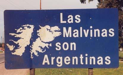
10 Language and history one name or more? Univocity or multiple names to recognize language traditions? Mount Taranaki or Mount Egmont Mackenzie River has 7 official names Aoraki/Mount Cook


11 Time sequence of names authorities Historically many lists of place names (e.g. explorers maps) Early boards USA 1890 Canada 1897 Denmark 1910 Iceland 1935 New Zealand 1946 Ireland 1946 Now ~ 80 countries have national authorities Most recent: Saudi Arabia, Burkina Faso, Tunisia Sri Lanka, Denmark - Føroyar Mozambique, Afghanistan, Serbia, Brazil Although established by law some boards are non-functional

12 Geographical Names Authorities (01/2015)


13 What is important?
14 Benefits of standardized names? Technical benefits e.g. Mapping / GIS Information management Economic benefits e.g. Infrastructure Tourism promotion Delivery services Social benefits e.g. Urban planning Humanitarian aid Search and rescue Cultural benefits e.g. Recording history Language retention Identity
 Earthquake in Pakistan, 2005 delays in")

15 Lack of standardized data United Nations Office for the Coordination of Humanitarian Affairs (OCHA) Earthquake in Pakistan, 2005 delays in providing assistance to remote villages difficult to obtain - standardized names, coordinates of villages, gazetteers, population statistics, maps

16 Data or scrambled eggs? Duplication Repetition Lack of standardization Incomplete data Resources lost Security compromised Confusion Bad decisions
 SCUFN online gazetteer http://www.iho.")
17 IHO & SCUFN International Hydrographic Organization (IHO) GEBCO Sub-Committee on Undersea Feature Names (SCUFN) IHO coordinating activities no decisions on ocean names, but influence through publications S-23 Limits of Oceans and Seas (update 1953 edition) SCUFN online gazetteer
")

 http://www.iau.org http://planetarynames.")
18 Beyond Earth - IAU International Astronomical Union (IAU) Working Group for Planetary System Nomenclature (WGPSN) 1919 By early 1970s great interest in space exploration and features on the Moon and the planets 1973 WGPSN authorizes names Gazetteer of Planetary Nomenclature (USGS maintains online)


19 Continued need for standardized geographical names Thank you!
Preserving cultural heritage through geographical names
 Brazil, 2017 Preserving cultural heritage through geographical names Helen Kerfoot (Canada) Former UNGEGN Chair Geographical names pivotal role Reference points Cultural links Geographical names Database
Raising awareness about advantages of standardization of geographical names / Des avantages de la normalisation
 Madagascar, 2013 Raising awareness about advantages of standardization of geographical names / Des avantages de la normalisation Helen Kerfoot Past Chair, UNGEGN (2002-2012) (Natural Resources Canada)
United Nations Group Of Experts On Geographical Names
 Rudolph MATINDAS, Indonesia or William WATT, Australia Key words: place names, UNGEGN SUMMARY UNGEGN Discussing the strategic aims of UNGEGN and its divisional structure, future direction, and the benefits
Resolutions from the Tenth United Nations Conference on the Standardization of Geographical Names, 2012, New York*
 UNITED NATIONS GROUP OF EXPERTS ON GEOGRAPHICAL NAMES Twenty-eighth session New York, 28 April 2 May 2014 GEGN/28/9 English Resolutions from the Tenth United Nations Conference on the Standardization of
United Nations, UNGEGN, and support for national geographical names standardization programmes
 Philippines, 2018 United Nations, UNGEGN, and support for national geographical names standardization programmes Helen Kerfoot, UNGEGN Cecille Blake, UNGEGN Secretariat What is important to know? Background
Economic and Social Council
 United Nations Economic and Social Council Distr.: General 23 May 2012 Original: English E/CONF.101/100 Tenth United Nations Conference on the Standardization of Geographical Names New York, 31 July 9
LIST OF DOCUMENTS* GROUP OF EXPERTS ON GEOGRAPHICAL NAMES. Twenty-seventh session 15 June 2016 New York, 28 April 2 May 2014
 UNITED NATIONS GROUP OF EXPERTS ON GEOGRAPHICAL NAMES GEGN/29/5/Rev.4 Twenty-seventh session 15 June 2016 New York, 28 April 2 May 2014 LIST OF DOCUMENTS* * Prepared by the UNGEGN Secretariat Symbol Title/Country
Turkey National Report
 UNITED NATIONS Working Paper GROUP OF EXPERTS ON No. 26 GEOGRAPHICAL NAMES Twenty-third Session Vienna, 28 March 4 April 2006 Item 5 of the Provisional Agenda: Reports of the division Turkey National Report
Standardization of geographical names and raising awareness of its advantages
 Brazil, 2017 Standardization of geographical names and raising awareness of its advantages Helen Kerfoot (Canada) Past Chair, UNGEGN (2002-2012) Need to understand What is our focus? Communication through
Economic and Social Council
 United Nations Economic and Social Council Distr.: General 15 May 2012 Original: English E/CONF.101/4 Tenth United Nations Conference on the Standardization of Geographical Names New York, 31 July 9 August
7 TO 17 AUGUST 2017 NEW YORK. TASK TEAM FOR AFRICA by. Brahim Atoui : TTA, Convenor
 7 TO 17 AUGUST 2017 NEW YORK TASK TEAM FOR AFRICA by Brahim Atoui : TTA, Convenor Geographical Names standardization in Africa: Challenges and constraints A decade of actions BRIEF HISTORY African Countries
ECONOMIC AND SOCIAL COUNCIL 13 July 2007
 UNITED NATIONS E/CONF.98/CRP.34 ECONOMIC AND SOCIAL COUNCIL 13 July 2007 Ninth United Nations Conference on the Standardization of Geographical Names New York, 21-30 August 2007 Item 17(b) of the provisional
LIST OF DOCUMENTS* Eleventh United Nations Conference on the Standardization of Geographialc Names. New York, 8 17 August August 2017
 Eleventh United Nations Conference on the Standardization of Geographialc Names E/CONF./INF/ New York, 1 August 201 August 201 LIST OF DOCUMENTS* * Prepared by the UNGEGN Secretariat E/CONF./1 E/CONF./2
E/CONF.105/158/CRP.158
 E/CONF.105/158/CRP.158 14 July 2017 Original: English Eleventh United Nations Conference on the Standardization of Geographical Names New York, 8-17 August 2017 Item 8 of the provisional agenda* Measures
D.N.D. Hettiarachchi (Hetti) Survey Department, Sri Lanka.
 Survey Department, Sri Lanka.") ADMINISTRATION OF GEOGRAPHICAL NAMES IN SRI LANKA D.N.D. Hettiarachchi (Hetti) Survey Department, Sri Lanka. hettiarachchidnd@gmail.com Country: Sri Lanka What is the official language(s)? Sinhala and
ADMINISTRATION OF GEOGRAPHICAL NAMES IN SRI LANKA D.N.D. Hettiarachchi (Hetti) Survey Department, Sri Lanka. hettiarachchidnd@gmail.com Country: Sri Lanka What is the official language(s)? Sinhala and
Geographical Names: Detailing Map and Enhancing GIS
 Geographical Names: Detailing Map and Enhancing GIS Zainal A MAJEED, MALAYSIA Keywords: geographical names, GIS, geographic name standardization, toponymy SUMMARY The necessity of having geographical names
Geographical Names Activities in Africa The Gaborone Action Plan
 United Nations Group of Experts on Geographical Names Geographical Names Activities in Africa The Gaborone Action Plan 6 th Meeting of the Committee of Director -Generals of National Statistics Offices
8th FIG Regional Conference November 2012 Montevideo, Uruguay
 8th FIG Regional Conference 26 29 November 2012 Montevideo, Uruguay Platinum Sponsors: Member Associations; Affiliate Members; Academic Members; Corporate Members & Correspondents 120 Countries 1 FIG Foundation
E/CONF.105/115/CRP.115***
 E/CONF.105/115/CRP.115*** 30 June 2017 Original: English 11 th United Nations Conference on the Standardization of Geographical Names New York, 8-17 August 2017 Item 9a) of the provisional agenda* National
E/CONF.105/75/CRP.75. Report of the Republic of Belarus
 E/CONF.105/75/CRP.75 23 June 2017 Original: Russian 11 th United Nations Conference on the Standardization of Geographical Names New York, 8-17 August 2017 Item 5 of the provisional agenda* Reports by
GROUP OF EXPERTS ON GEOGRAPHICAL NAMES. Twenty-fifth session Nairobi, 5 12 May List of Documents * * Submitted by the UNGEGN Secretariat
 UNITED NATIONS GROUP OF EXPERTS ON GEOGRAPHICAL NAMES GEGN/2/ Twenty-fifth session Nairobi, May 200 List of Documents * * Submitted by the UNGEGN Secretariat Symbol Title Agenda Item GEGN/2/1 Provisional
CARTOGRAPHY. Seventh United Nations Conference on the of Geographical Names. Report of the Secretary-Gener?l
 TO: FROM; DESA/STAT DATE: Mon Apr 24 2000 05:34 EOT ECONOMIC AND SOCIAL COUNCIL Distr. GENERAL DRAFT (30 April 1998) ORIGINAL: ENGLISH Substantive Session of 1998 6-31 July 1998 Item 13 (f) of the provisional
Standardization of geographical names and raising awareness of its advantages
 Philippines, 2018 Standardization of geographical names and raising awareness of its advantages Helen Kerfoot (Canada) Past Chair, UNGEGN (2002-2012) Need to understand What is our focus? Communication
Final report for the Expert Group on the Integration of Statistical and Geospatial Information, May 2015
 Final report for the Expert Group on the Integration of Statistical and Geospatial Information, May 2015 Global geographic classification and geocoding practices Executive summary This final report was
From PCGIAP to UN GGIM AP: A Regional Perspective on GGIM
 Regional Committee of United Nations Global Geospatial Information Management for Asia and the Pacific (UN-GGIM-AP) Established by a United Nations Resolution From PCGIAP to UN GGIM AP: A Regional Perspective
Briefing Notes for World Hydrography Day
 Briefing Notes for World Hydrography Day - 2017 Mapping our seas, oceans and waterways - more important than ever Purpose of World Hydrography Day In 2005, the General Assembly of the United Nations (UN)
Current Status of the Standardization of Geographical Names in Cambodia
 1 Current Status of the Standardization of Geographical Names in Cambodia His Excellency Ith Sotha, Under Secretary of States, MLMUPC Mr Chharom Chin, Deputy Director, Geography Department, MLMUPC Mr Narith
Identification of Islands and Standardization of Their Names
 Identification of Islands and Standardization of Their Names Submitted by INDONESIA UNITED NATIONS GROUP OF EXPERTS ON GEOGRAPHICAL NAMES Eleventh United Nations Conference on the Standardization of Geographical
UN GGIM and National SDI Strategy
 MSDI Open Forum on 26 th January 2016 Contributing to the successful delivery of MSDI UN GGIM and National SDI Strategy Hiroshi Murakami Deputy Administrator Geospatial Information Authority of Japan Geospatial
Nigerian Capital Importation QUARTER THREE 2016
 Nigerian Capital Importation QUARTER THREE 2016 _ November 2016 Capital Importation Data The data on Capital Importation used in this report was obtained from the Central Bank of Nigeria (CBN). The data
Preparing for fieldwork: what should we collect and what forms should we use?
 Brazil, 2017 Preparing for fieldwork: what should we collect and what forms should we use? Helen Kerfoot Canada UNGEGN Fieldwork Many different approaches to fieldwork Aims of field collection To verify
Guidelines for the consistent use of place names in Australia
 5 June 2002 English only Eighth United Nations Conference on the Standardization of Geographical Names Berlin, 27 August-5 September 2002 Item 9 (e) of the provisional agenda* National standardization:
UNITED NATIONS E/CONF.96/CRP. 5
 UNITED NATIONS E/CONF.96/CRP. 5 ECONOMIC AND SOCIAL COUNCIL Eighth United Nations Regional Cartographic Conference for the Americas New York, 27 June -1 July 2005 Item 5 of the provisional agenda* COUNTRY
January 2018 Special Preview Edition
 January 2018 Special Preview Edition What s inside this booklet? The contents you ll explore 2 Americas 4 Europe 6 Far East & Oceania 8 Central & South Asia 10 Africa & Middle East 12 International 14
IHO Input to the Report of the UN Secretary General on Oceans and Law of the Sea Executive Summary General
 IHO Input to the Report of the UN Secretary General on Oceans and Law of the Sea The following notes provide information on activities of the International Hydrographic Organization that are relevant to
* E/C ONF * "Prepared by the Directorate of Geodesy and Cartography, Ministry of Regional Development and Public Works.
 3 September 2002 Original: Engiish Eighth United Nations Conference on the Standardization of Geographical Names Berlín, 27 August-5 September 2002 Item 4 of the provisional agenda" REPORTS BY GOVERNMENTS
Report of the United Kingdom Division
 UNITED NATIONS GROUP OF EXPERTS WORKING PAPER ON GEOGRAPHICAL NAMES NO. 41/4 Twenty-ninth session Bangkok, Thailand, 25 29 April 2016 Item 4 of the Provisional Agenda Report of the Divisions Report of
Alleghany County Schools Curriculum Guide GRADE/COURSE: World Geography
 GRADE/COURSE: World 2013-14 GRADING PERIOD: 1 st Six Weeks Time Frame Unit/SOLs SOL # Strand Resource Assessment 8 days* The student will use maps, globes, satellite images, photographs, or diagrams to
EUMETSAT. A global operational satellite agency at the heart of Europe. Presentation for the Spanish Industry Day Madrid, 15 March 2012
 EUMETSAT A global operational satellite agency at the heart of Europe Presentation for the Spanish Industry Day Madrid, Angiolo Rolli EUMETSAT Director of Administration EUMETSAT objectives The primary
Space-based technology and applications and space science for humanitarian affairs, environment and security
 Space-based technology and applications and space science for humanitarian affairs, environment and security LUC ST-PIERRE United Nations Office for Outer Space Affairs United Nations Office at Vienna
RESOLUTIONS ADOPTED AT THE NINE UNITED NATIONS CONFERENCES ON THE STANDARDIZATION OF GEOGRAPHICAL NAMES
 RESOLUTIONS ADOPTED AT THE NINE UNITED NATIONS CONFERENCES ON THE STANDARDIZATION OF GEOGRAPHICAL NAMES 1967, 1972, 1977, 1982, 1987, 1992, 1998, 2002, 2007 * * * * * * A. LISTED BY SUBJECT B. CROSS-REFERENCED
Canadian Imports of Honey
 of 0409000029 - Honey, natural, in containers of a weight > 5 kg, nes (Kilogram) Argentina 236,716 663,087 2,160,216 761,990 35.27% 202.09% /0 76,819 212,038 717,834 257,569 35.88% 205.69% /0 United States
PRINCIPLES AND APPLICATIONS of OCEAN FEATURE NOMENCLATURE
 PRINCIPLES AND APPLICATIONS of OCEAN FEATURE NOMENCLATURE Michel HUET International Hydrographic Bureau MONACO "Undersea feature" is a part of the ocean floor or seabed that has measurable relief or is
UN-GGIM: An Overview Stefan Schweinfest, Director (UNSD) Bangkok, 27 March 2015
 Bangkok, 27 March 2015") UN-GGIM: An Overview Stefan Schweinfest, Director (UNSD) Bangkok, 27 March 2015 ggim.un.org UN-GGIM: A global initiative Formal inter-governmental UN Committee of Experts to: Discuss, enhance and coordinate
UN-GGIM: An Overview Stefan Schweinfest, Director (UNSD) Bangkok, 27 March 2015 ggim.un.org UN-GGIM: A global initiative Formal inter-governmental UN Committee of Experts to: Discuss, enhance and coordinate
RESOLUTIONS ADOPTED AT THE TEN UNITED NATIONS CONFERENCES ON THE STANDARDIZATION OF GEOGRAPHICAL NAMES
 RESOLUTIONS ADOPTED AT THE TEN UNITED NATIONS CONFERENCES ON THE STANDARDIZATION OF GEOGRAPHICAL NAMES 1967, 1972, 1977, 1982, 1987, 1992, 1998, 2002, 2007, 2012 * * * * * * A. LISTED BY SUBJECT B. CROSS-REFERENCED
Victor C. NNAM, Bernard O. EKPETE and Obinna C. D. ANEJIONU, Nigeria
 IMPROVING STREET GUIDE MAPPING OF ENUGU SOUTH URBAN AREA THROUGH COMPUTER AIDED CARTOGRAPHY By Victor C. NNAM, Bernard O. EKPETE and Obinna C. D. ANEJIONU, Nigeria Presented at FIG Working Week 2012 Knowing
International Student Enrollment Fall 2018 By CIP Code, Country of Citizenship, and Education Level Harpur College of Arts and Sciences
 International Student Enrollment Fall 2018 By CIP Code, Country of Citizenship, and Education Level Harpur College of Arts and Sciences CIP Code Description Citizenship Graduate Undergrad Total 00.0000
Toponymy workshop of Tunis: A road map to orient the activities of the national committee of toponymy
 UNITED NATIONS GROUP OF EXPERTS WORKING PAPER ON GEOGRAPHICAL NAMES NO. 33/8 Twenty-ninth session Bangkok, Thailand, 25 29 April 2016 Item 8 of the Provisional Agenda Activities relating to the Working
R E P U B L I C O F C Y P R U S NATIONAL REPORT OF CYPRUS TO THE MEDITERRANEAN AND BLACK SEAS HYDROGRAPHIC COMMISSION (MBSHC)
") R E P U B L I C O F C Y P R U S NATIONAL REPORT OF CYPRUS TO THE MEDITERRANEAN AND BLACK SEAS HYDROGRAPHIC COMMISSION (MBSHC) ISTANBUL MEETING 25-27 SEPTEMBER 2013 NATIONAL REPORT OF CYPRUS TO THE MEDITERRANEAN
R E P U B L I C O F C Y P R U S NATIONAL REPORT OF CYPRUS TO THE MEDITERRANEAN AND BLACK SEAS HYDROGRAPHIC COMMISSION (MBSHC) ISTANBUL MEETING 25-27 SEPTEMBER 2013 NATIONAL REPORT OF CYPRUS TO THE MEDITERRANEAN
Report of the Working Group 2 Data Sharing and Integration for Disaster Management *
 UNITED NATIONS E/CONF.104/6 ECONOMIC AND SOCIAL COUNCIL Twentieth United Nations Regional Cartographic Conference for Asia and the Pacific Jeju, 6-9 October 2015 Item 5 of the provisional agenda Report
A COMPREHENSIVE WORLDWIDE WEB-BASED WEATHER RADAR DATABASE
 A COMPREHENSIVE WORLDWIDE WEB-BASED WEATHER RADAR DATABASE Oguzhan SİRECİ 1, Paul JOE 2, Serkan EMINOGLU 3, Kamuran AKYILDIZ 4 1 Turkish State Meteorological Service(TSMS), Kecioren, Ankara Turkey,osireci@gmail.com
Almaty Programme of Action
 Almaty Programme of Action Addressing the Special Needs of Landlocked Developing Countries within a New Global Framework for Transit Transport Cooperation for Landlocked and Transit Developing Countries
MALDIVES. Regional Expert Workshop On Land Accounting For SDG Monitoring & Reporting (25-27 th Sept 2017) - Fathimath Shanna, Aishath Aniya -
 - Fathimath Shanna, Aishath Aniya -") MALDIVES Regional Expert Workshop On Land Accounting For SDG Monitoring & Reporting (25-27 th Sept 2017) - Fathimath Shanna, Aishath Aniya - ABOUT MALDIVES Approximately 860 km long and 120 km wide Consists
MALDIVES Regional Expert Workshop On Land Accounting For SDG Monitoring & Reporting (25-27 th Sept 2017) - Fathimath Shanna, Aishath Aniya - ABOUT MALDIVES Approximately 860 km long and 120 km wide Consists
Economic and Social Council 2 July 2015
 ADVANCE UNEDITED VERSION UNITED NATIONS E/C.20/2015/11/Add.1 Economic and Social Council 2 July 2015 Committee of Experts on Global Geospatial Information Management Fifth session New York, 5-7 August
UNITED NATIONS E/CONF.97/5/CRP. 7
 UNITED NATIONS E/CONF.97/5/CRP. 7 ECONOMIC AND SOCIAL COUNCIL Seventeenth United Nations Regional Cartographic Conference for Asia and the Pacific Bangkok, 18-22 September 2006 Item 6 (b) of the provisional
Inventory of United Nations Resolutions on Cartography Coordination, Geographic Information and SDI 1
 Inventory of United Nations Resolutions on Cartography Coordination, Geographic Information and SDI I. Resolutions on Cartography Coordination and Establishment of United Nations Regional Cartographic
United Nations, UNGEGN, and support for national geographical names standardization programmes
 Brazil, 2017 United Nations, UNGEGN, and support for national geographical names standardization programmes Helen Kerfoot, Cecille Blake UNGEGN What is important to know? Background on UNGEGN Aims of the
Geospatial framework for monitoring SDGs/Sendai targets By Shimonti Paul Sr. Assistant Editor Geospatial Media & Communications
 Geospatial framework for monitoring SDGs/Sendai targets By Shimonti Paul Sr. Assistant Editor Geospatial Media & Communications Outline 1. Introduction to Geospatial Media and Communications 2. Geospatial
ADMINISTRATION OF GEOGRAPHICAL NAMES IN URUGUAY
 ADMINISTRATION OF GEOGRAPHICAL NAMES IN URUGUAY 1st. Lt. Julio C. Teixeira Executive Officer Geodesy & Topography Division Military Geographic Service Av. 8 de Octubre 3255. Montevideo, URUGUAY Telph.:
ECONOMIC AND SOCIAL COUNCIL
 United Nations E/CONF.101/INF/5/Rev. ECONOMIC AND SOCIAL COUNCIL February 2013 Tenth United Nations Conference on the Standardization of Geographical Names New York, 31 July to 9 August 2012 LIST OF DOCUMENTS*
GLOBAL NETWORK OF NATIONAL GEOPARKS. Patrick J Mc Keever
 Patrick J Mc Keever A GEOPARK is an area with. geological heritage of international significance but also with. a sustainable development strategy or plan involving local communities. IS A GEOPARK JUST
ACCESSIBILITY TO SERVICES IN REGIONS AND CITIES: MEASURES AND POLICIES NOTE FOR THE WPTI WORKSHOP, 18 JUNE 2013
 ACCESSIBILITY TO SERVICES IN REGIONS AND CITIES: MEASURES AND POLICIES NOTE FOR THE WPTI WORKSHOP, 18 JUNE 2013 1. Significant differences in the access to basic and advanced services, such as transport,
Economic and Social Council
 United Nation E/C.20/2012/4/Add.1 Economic and Social Council Distr.: General 2 July 2012 Original: English Committee of Experts on Global Geospatial Information Management Second session New York, 13-15
Economic and Social Council
 United Nations Economic and Social Council Distr.: General 6 June 2012 Original: English E/CONF.101/138 Tenth United Nations Conference on the Standardization of Geographical Names New York, 31 July 9
Second Administrative Level Boundaries (SALB) initiative & geographic names in cartography. Geospatial Information Section
 initiative & geographic names in cartography. Geospatial Information Section") Second Administrative Level Boundaries (SALB) initiative & geographic names in cartography Geospatial Information Section Introduction Goals Global agenda How does SALB work? Latest News on geographic
Second Administrative Level Boundaries (SALB) initiative & geographic names in cartography Geospatial Information Section Introduction Goals Global agenda How does SALB work? Latest News on geographic
Summary of Global Mapping Forum 2003 in Okinawa and its Outcomes
 Summary of Global Mapping Forum 2003 in Okinawa and its Outcomes 1 Summary of Global Mapping Forum 2003 in Okinawa and its Outcomes Hidetoshi NAKAJIMA Abstract Global Mapping Forum 2003 in Okinawa was
RESOLUTIONS ADOPTED AT THE ELEVEN UNITED NATIONS CONFERENCES ON THE STANDARDIZATION OF GEOGRAPHICAL NAMES
 RESOLUTIONS ADOPTED AT THE ELEVEN UNITED NATIONS CONFERENCES ON THE STANDARDIZATION OF GEOGRAPHICAL NAMES 1967, 1972, 1977, 1982, 1987, 1992, 1998, 2002, 2007, 2012, 2017 * * * * * * A. LISTED BY SUBJECT
Georeferencing and Satellite Image Support: Lessons learned, Challenges and Opportunities
 Georeferencing and Satellite Image Support: Lessons learned, Challenges and Opportunities Shirish Ravan shirish.ravan@unoosa.org UN-SPIDER United Nations Office for Outer Space Affairs (UNOOSA) UN-SPIDER
International and regional network status
 WORLD METEOROLOGICAL ORGANIZATION JOINT MEETING OF CBS EXPERT TEAM ON SURFACE-BASED REMOTELY- SENSED OBSERVATIONS (Second Session) AND CIMO EXPERT TEAM ON OPERATIONAL REMOTE SENSING (First Session) CBS/ET-SBRSO-2
Seabed knowledge In support of UN SDGs
 Seabed knowledge In support of UN SDGs Evert Flier Fiskerifaglig forum 2. november 2017 Hydrography & small scale fishing Hydrography in Transition Serving the Maritime Community Hydrography in Transition
I Background. Under the Cotton Tree: Situs Addressing System in Africa. Table of contents
 Cairo, April 2005 Under the Cotton Tree: Situs Addressing System in Africa Table of contents 1. Background 2. Current situation of addressing system in Africa 3. Benefits of a functional addressing system
Report to ICA on the work of the United Nations Group of Experts on Geographical Names (UNGEGN) (slide 1)
 (slide 1)") Report to ICA on the work of the United Nations Group of Experts on Geographical Names (UNGEGN) (slide 1) I thank the Hungarian colleagues for inviting me, indeed I am most lucky to have friends in high
Report to ICA on the work of the United Nations Group of Experts on Geographical Names (UNGEGN) (slide 1) I thank the Hungarian colleagues for inviting me, indeed I am most lucky to have friends in high
Global Geospatial Information Management in Tunisia Situation and Future prospects
 Republic of Tunisia Ministry of National Defense National Mapping and Remote Sensing Center (NMRC) Global Geospatial Information Management in Tunisia Situation and Future prospects Qatar, February 2013
Geospatial Policy Development and Institutional Arrangements *
 HIGH LEVEL FORUM ON GLOBAL GEOSPATIAL MANAGEMENT INFORMATION WORKING PAPER No. 13 First Forum Seoul, Republic of Korea, 24-26 October 2011 Geospatial Policy Development and Institutional Arrangements *
Economic and Social Council
 United Nations Economic and Social Council Distr.: General 2 July 2012 E/C.20/2012/10/Add.1 Original: English Committee of Experts on Global Geospatial Information Management Second session New York, 13-15
Arctic Spatial Data Infrastructure Enabling Access to Arctic Location-Based Information
 Arctic Spatial Data Infrastructure Enabling Access to Arctic Location-Based Information Arctic SDI Side Event Co-Chairs: Arvo Kokkonen Arctic SDI Board Chair & Director General, National Land Survey of
Marine Spatial Planning in Hellas; Recent Facts and Perspectives
 XXV FIG CONGRESS Engaging the Challenges, Enhancing the Relevance Kuala Lumpur, Malaysia 16 21 June 2014 Marine Spatial Planning in Hellas; Recent Facts and Perspectives Mrs. Chaiditsa BOLANOU Surveying
Government GIS and its Application for Decision Support
 Government GIS and its Application for Decision Support Zhang Qingpu (Chinese Academy of Surveying and Mapping, Email: zhangqp@casm.ac.cn) Abstract: Application of GIS in government agencies is called
E/CONF.105/69/CRP.69. China s Campaign to Clean up and Standardize Non-standard Geographical Names
 E/CONF.105/69/CRP.69 23 June 2017 Original: Chinese 11 th United Nations Conference on the Standardization of Geographical Names New York, 8-17 August 2017 Item 9 of the provisional agenda* National standardization
UNITED NATIONS GEOGRAPHIC INFORMATION WORKING GROUP
 UNGIWG UNITED NATIONS GEOGRAPHIC INFORMATION WORKING GROUP New York, May 2014 UNSPACE & UNGIWG 14 INTRO. The United Nations Geographic Information Working Group (UNGIWG) is a voluntary network of UN professionals
General Bathymetric Chart of the Oceans
 General Bathymetric Chart of the Oceans GEBCO A look at the world from an ocean s perspective On behalf of GEBCO: Boris Dorschel 1, Martin Jakobsson 2 1 Department of Geophysics, Alfred Wegener Institute
Nepal (Countries & Cities Of The World) [Import] [Map]
![Nepal (Countries & Cities Of The World) [Import] [Map]](/thumbs/89/98730252.jpg "Nepal (Countries & Cities Of The World) [Import] [Map]") Nepal (Countries & Cities Of The World) [Import] [Map] If you are searched for a book Nepal (Countries & Cities of the World) [Import] [Map] in pdf format, then you've come to faithful site. We furnish
Nepal (Countries & Cities Of The World) [Import] [Map] If you are searched for a book Nepal (Countries & Cities of the World) [Import] [Map] in pdf format, then you've come to faithful site. We furnish
8 th Arctic Regional Hydrographic Commission Meeting September 2018, Longyearbyen, Svalbard Norway
 8 th Arctic Regional Hydrographic Commission Meeting 11-13 September 2018, Longyearbyen, Svalbard Norway Status Report of the Arctic Regional Marine Spatial Data Infrastructures Working Group (ARMSDIWG)
Report of Uruguay The National Spatial Data Infrastructure
 Report of Uruguay The National Spatial Data Infrastructure Prepared for High-Level Forum on Global Geospatial Information Management (GGIM) and Inaugural Session of the UN Committee of Experts on GGIM
Overview of Technical Advisory Missions
 Expert Group Meeting (EGM) on Georeferenced Information Systems for Disaster Risk Management (Geo-DRM) and sustaining the Community of Practice (COP) 23-25 April 2014 Bangkok Overview of Technical Advisory
Briefing on the work of GEBCO (GENERAL BATHYMETRIC CHART OF THE OCEANS)
") Briefing on the work of GEBCO (GENERAL BATHYMETRIC CHART OF THE OCEANS) 7th ROPME Sea Area Hydrographic Commission Meeting, Muscat, Oman 20-22 February 2017 What is GEBCO? The General Bathymetric Chart
Briefing on the work of GEBCO (GENERAL BATHYMETRIC CHART OF THE OCEANS) 7th ROPME Sea Area Hydrographic Commission Meeting, Muscat, Oman 20-22 February 2017 What is GEBCO? The General Bathymetric Chart
About the Authors Geography and Tourism: The Attraction of Place p. 1 The Elements of Geography p. 2 Themes of Geography p. 4 Location: The Where of
 Preface p. ix About the Authors p. xi Geography and Tourism: The Attraction of Place p. 1 The Elements of Geography p. 2 Themes of Geography p. 4 Location: The Where of Geography p. 4 Place and Space:
UN-GGIM: Strengthening Geospatial Capability
 Fifth Plenary Meeting of UN-GGIM: Europe Brussels, 6-7 June 2018 UN-GGIM: Strengthening Geospatial Capability Walking the talk to leave no one behind Greg Scott, UN-GGIM Secretariat Environmental Statistics
Publication Date: 15 Jan 2015 Effective Date: 12 Jan 2015 Addendum 6 to the CRI Technical Report (Version: 2014, Update 1)
") Publication Date: 15 Jan 2015 Effective Date: 12 Jan 2015 This document updates the Technical Report (Version: 2014, Update 1) and details (1) Replacement of interest rates, (2) CRI coverage expansion,
Publication Date: 15 Jan 2015 Effective Date: 12 Jan 2015 This document updates the Technical Report (Version: 2014, Update 1) and details (1) Replacement of interest rates, (2) CRI coverage expansion,
Report of the Regional Committee of UN-GGIM for Asia and the Pacific (UN-GGIM-AP)
") Report of the Regional Committee of UN-GGIM for Asia and the Pacific (UN-GGIM-AP) At the Eighth Session of UN-GGIM UN Headquarters, New York, 1 3 August 2018 About UN-GGIM-AP One of the five regional committees
Report of the Regional Committee of UN-GGIM for Asia and the Pacific (UN-GGIM-AP) At the Eighth Session of UN-GGIM UN Headquarters, New York, 1 3 August 2018 About UN-GGIM-AP One of the five regional committees
EO Information Services. Assessing Vulnerability in the metropolitan area of Rio de Janeiro (Floods & Landslides) Project
 Project") EO Information Services in support of Assessing Vulnerability in the metropolitan area of Rio de Janeiro (Floods & Landslides) Project Ricardo Armas, Critical Software SA Haris Kontoes, ISARS NOA World
EO Information Services in support of Assessing Vulnerability in the metropolitan area of Rio de Janeiro (Floods & Landslides) Project Ricardo Armas, Critical Software SA Haris Kontoes, ISARS NOA World
LOUISIANA STUDENT STANDARDS FOR SOCIAL STUDIES THAT CORRELATE WITH A FIELD TRIP TO DESTREHAN PLANTATION KINDERGARTEN
 LOUISIANA STUDENT STANDARDS FOR SOCIAL STUDIES THAT CORRELATE WITH A FIELD TRIP TO DESTREHAN PLANTATION KINDERGARTEN Standard 2 Historical Thinking Skills Students distinguish between events, people, and
- West Africa. Abuja, Nigeria May Fredericton Canada Heeswijk The Netherlands Washington DC United States Adelaide Australia
 A Case Study in Land and Sea Data Interoperability Patricia GASPAR(Netherlands), Andrew HOGGARTH(Canade), Gordon JOHNSTON(UK), Charles de JONG(Netherlands) - West Africa Abuja, Nigeria - 6-10 May 2013
16540/14 EE/cm 1 DG E 1A
 Council of the European Union Brussels, 5 December 2014 (OR. en) 16540/14 ENV 965 CULT 139 NOTE From: To: Subject: General Secretariat of the Council Delegations Charter of Rome on Natural and Cultural
Developing a global, peoplebased definition of cities and settlements
 Developing a global, peoplebased definition of cities and settlements By Lewis Dijkstra, Lewis.Dijkstra@ec.europa.eu Head of the Economic Analysis Sector DG for Regional and Urban Policy, Regional & Urban
SDG s and the role of Earth Observation
 SDG s and the role of Earth Observation Christian Heipke IPI - Institute for Photogrammetry and GeoInformation Leibniz Universität Hannover Germany Secretary General, ISPRS 1. No Poverty 2. Zero Hunger
DRAFT CONCEPT NOTE. WDR 2008: Agriculture for Development WDR 2007: Development and the Next Generation WDR 2006: Equity and Development
 WORLD DEVELOPMENT REPORT, WDR 2009 RESHAPING ECONOMIC GEOGRAPHY CONSULTATION - MENA REGION MAY 5-6, 2008 DRAFT CONCEPT NOTE The World Bank publishes each year a World Development Report (WDR) focusing
CLLD Cooperation OFFER
 Title of the proposed project (English) CLLD Cooperation OFFER PARKS PROTECTION III - Management, Protection and Economic Development in Protected Areas Type of project (select as many as you want) Cooperation
The list of Polish geographical names of the world. Maciej Zych
 The list of Polish geographical names of the world Maciej Zych 21st Session of the East Central and South-East Europe Division of the United Nations Group of Experts on Geographical Names Ljubljana, 26th
NOMAD Workshop Linking Humanitarian Organizations with Mobile Data Collection Tool Providers, 15 th -17 th May, Paris!
 NOMAD Workshop Linking Humanitarian Organizations with Mobile Data Collection Tool Providers, 15 th -17 th May, Paris! Their Work is Contributing to build a Better World... IAEA UNODC Public Health Global