SUPPLEMENTARY INFORMATION
|
|
|
- Ralph Harrington
- 6 years ago
- Views:
Transcription
1 SUPPLEMENTARY INFORMATION SqueeSAR TM and GPS Ground Deformation Monitoring of Santorini Volcano (1992-): Tectonic Implications By Lagios 1 E., Sakkas 1 V., Novali 2 F., Bellotti 2 F., Ferretti 2 A., Vlachou 1 K. & Dietrich 3 V. (1) Remote Sensing Laboratory, Geophysics-Geothermics Dept., University of Athens, Panepistimiopolis-Ilissia, Athens , Greece. (2) Tele-Rilevamento Europa T.R.E. s.r.l., Ripa di Porta Ticinese 79, Milano 21149, Italy. (3) Institute for Geochemistry and Petrology, Swiss Federal Institute of Technology, CH-8092 Zurich, Switzerland Contents 1. Inferred Faults from Geophysical Analysis 2 2. Comparing GPS and SqueeSAR (Period ) 6 3. Strain Field Deduced by GPS Measurements (Unrest Period) 7 4. Mogi Model Parameter Estimates by various Authors 8 5. Estimated CGPS Velocities for Distinct Periods 9 6. PS/DS Time Series for selected points in Nea Kammeni & Therassia for the Period PS/DS Time Series for selected points in Kammenis & Imerovigli for the Period
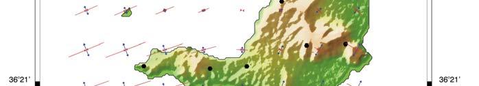
2 1. Inferred Faults from Geophysical Analysis A new Gravity Anomaly Map of Santorini (Fig. 1) was recently homogenized and compiled by Chailas et al. () using more than 550 gravity measurements from various sources (Yokoyama and Bonasia, 1971; 1979; Budetta et al., 1984; Vassiliadis, 1985; Lagios, 1995; National Geophysical Data Center (USA), ). A focus on the southern part of Thera is presented in this section with emphasis on the investigation of faults without a surface trace, and the possible basement extent at the south-eastern part. It is qualitatively clear from this map that the Alpine basement outcrop at the southern part of Thera, extending to the Monolithos area to the north, is associated with the gravity high where the anomaly values are higher than about 130 mgal. The gravity low (110 mgal) identified around the Akrotiri area is due to the low density overburden (eg. tuffs) and the partially met Akrotiri lavas. Results of a 3-D gravity inversion modeling that was performed at an attempt to investigate the subsurface basement variations and possible faults, together with the thickness of the pyroclastics, were also taken into consideration in this paper (after Chailas et al., ) at an attempt to model hidden faults. Data from the two boreholes S2 and S3 (Fytikas et al., 1989) along Profile AB (Fig. 1) were used to constrain the modeling. A density contrast of 1.7 Kg/m 3 was chosen based on laboratory measurements on basement samples from the southern area of Santorini, and published work (Budetta et al., 1984; Boyce and Gertisser, ). Two possible basement faults (running almost N-S and presented in Fig. 1) are interpreted along Profile AB, one between S2 and S3 boreholes, and another one about 2 km west of borehole S2, marking a depression (the Akrotiri Depression) in the broader area of Akrotiri. The location of these two faulting features is in agreement with earlier Audio-Magnetotelluric work carried out in that region for the exploration of its geothermal potential. Figure 2b shows the polarization ellipse of the maximum electric field and the real vectors averaged over the frequency interval 0.5 Hz to 0.01 Hz, which corresponds to relatively deep parts of the geoelectric structure (2 5 km). 2

3 Figure 1. Santorini Gravity Anomaly Map referred to IGSN 71 and GRF 67 Contour interval 2 mgal; AB: Gravity Profile along which the basement variation is shown deduced from a 3-D gravity inversion modeling. Two boreholes (marked as S2 and S3) were used for modeling control (after Chailas et al., ). 3
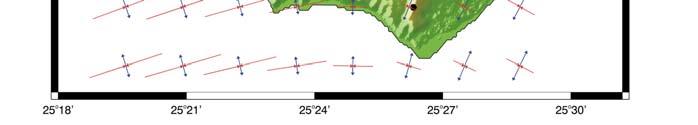
 is detected and comprises a relatively broad elongated conductor extending between the Akrotiri Peninsula and the Kammenis.")
4 The overall configuration of the electric field and current flow indicates that the deeper structure is simpler and smoother than the shallower structure (Fig. 2a). Only one large scale structural trend (striking N ) is detected and comprises a relatively broad elongated conductor extending between the Akrotiri Peninsula and the Kammenis. These two faults seem to play an important role in the kinematics of the southern part of Thera greatly controlling the observed deformation. (a) (b) Figure 2. The maximum characteristic states of the electric field (maximum impedance) and the real induction vectors, averaged (a) over the band 20 1 Hz (Shallower Structure), and (b) over the band Hz (Deeper Structure). The thick gray lines represent the approximate location of elongate conductors (after Papageorgiou et al., 2010). Additional References Boyce, J.A., Gertisser, R.,. Variations in welding characteristics within the Plinian air-fall deposit of the Middle Pumice eruption, Santorini, Greece. J. Volcan. Geothermal Res. 221/222, Budetta, G., Condarelli, D., Fytikas, M., Kolios, N., Pascale, G., Rapolla, A., Pinna, E., Geophysical prospecting on the Santorini Islands. Bull. Volcanol. 47(3),
5 Fytikas, M., Karydakis, G., Kavouridis, Th., Kolios, N., Vougioukalakis, G., Geothermal Research on Santorini. In: Thera and the Aegean World III, Volume Two: Earth Sciences, Proceedings of the Third International Congress. Santorini, Greece, 3-9 September Publisher: Thera Foundation (1990) ISBN: , National Geophysical Data Center (USA),. GEODAS Marine trackline geophysics Gravity, bathymetry, seismic, geophysical data (Data Banks). Vassiliadis, K. C., Geophysical Survey of Thera Island (Santorini) in the frame of the Geothermal Program of IGME. Internal IGME Report (in Greek), 10p. Yokoyama, I., Bonasia, V., A preliminary gravity survey on Thera Volcano, Greece. Acta, Yokoyama, I. and Bonasia, V., Gravity anomalies on the Thera Islands. in C. Doumas, (ed.). Thera and the Aegean World-I,
6 2. Comparing GPS and SqueeSAR (Period ) GPS Station V East GPS and SqueeSAR Velocity Field of SVC Referred to No. 07 GPS Velocity Field ( ) σv East V North σv North V Up σv Up V East SqueeSAR Velocity Field ( ) Deduced by Combined Ascending & Descending Radar Images σv East V North σv North V Up σv Up σ : velocity errors 6


7 3. Strain Field Deduced by GPS Measurements (Unrest Period) 7
 0.5 4.9 + 0.5 Volume (x10 6 m 3 ) 2.9 8.2 + 1.0 - - - - Sept. 2011 to Feb. 25.384 o E 36.429 o N Period Apr.")
8 4. Mogi Model Parameter Estimates by various Authors Author Lagios et al. (present paper) Newman et al. Parks et al. Papoutsis et al. Period Sept to June Sept to Jan. Mogi Model deduced by GPS Location o E o N o E o N Depth (km) Volume (x10 6 m 3 ) Sept to Feb o E o N Period Apr to Mar. Mogi Model deduced by InSAR (ENVISAT) Depth Location (km) o E o N Volume (x10 6 m 3 ) March to Dec Mar to Mar o E o N o E o N See also Santorini_GPS_net.kml file 8
9 5. Estimated CGPS Velocities for Distinct Periods July Feb. Feb. June June Nov. Nov. Dec. SANT East 89.8 ± ± ± ± 5.3 North 22.1 ± ± ± ± 5.2 Up 58.2 ± ± ± ± 14.4 RIBA East ± ± ± ±6.3 North 36.2 ± ± ± ±9.8 Up 61.1 ± ± ± ±31.7 KERA East ± ± ± ± 5.0 North ± ± ± ± 4.5 Up 57.9 ± ± ± ± 16.4 PKMN East -7.4 ± ± ± ± 4.1 North ± ± ± ± 4.8 Up 64.0 ± ± ± ± 13.4 NOMI East 79.6 ± ± ± ± 5.6 North ± ± ± ± 5.1 Up 57.3 ± ± ± ± 15.7 MOZI East 71.6 ± ± ± ± 4.5 North 55.3 ± ± ± ± 4.7 Up 64.4 ± ± ± ± 13.4 MKMN East ± ± North ± ± Up ± ± 5.3-9
10 10
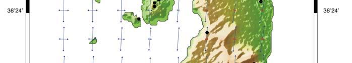
11 6. PS/DS Time Series for selected points in Nea Kammeni & Therassia for the Period
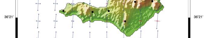
12 7. PS/DS Time Series for selected points in Kammenis & Imerovigli for the Period
SAR APPLICATIONS IN GREECE With emphasis for Harokopio University/ Dep. of Geography activities
 SAR APPLICATIONS IN GREECE With emphasis for Harokopio University/ Dep. of Geography activities Issaak Parcharidis, Assist. Prof. Harokopio University of Athens Department of Geography parchar@hua.gr 4
The Santorini Inflation Episode, Monitored by InSAR and GPS
 The Santorini Inflation Episode, Monitored by InSAR and GPS Ioannis Papoutsis 1,2, Xanthos Papanikolaou 2, Michael Floyd 3, Kang Hyeun Ji 4, Charalampos Kontoes 1, Demitris Paradissis 2, Demitris Anastasiou
Application of satellite InSAR data for hydrocarbon reservoir monitoring
 Application of satellite InSAR data for hydrocarbon reservoir monitoring A. Tamburini, A. Belson, A. Ferretti, F. Novali TRE Milano, Italy Copyright - Tele-Rilevamento Europa - 2004 Outline SqueeSAR TM
GEODETIC EVIDENCE FOR SLOW INFLATION OF THE SANTORINI CALDERA
 Proceedings, 11 th FIG Symposium on Deformation Measurements, Santorini, Greece, 2003. GEODETIC EVIDENCE FOR SLOW INFLATION OF THE SANTORINI CALDERA Stathis Stiros 1, Aris Chasapis 2 and Villy Kontogianni
SAR INTERFEROMETRIC ANALYSIS OF GROUND DEFORMATION AT SANTORINI VOLCANO (GREECE)
") SAR INTERFEROMETRIC ANALYSIS OF GROUND DEFORMATION AT SANTORINI VOLCANO (GREECE) Papageorgiou Elena (1), Foumelis Michael (2), Parcharidis Issaak (2) (1) National and Kapodistrian University of Athens,
SAR INTERFEROMETRIC ANALYSIS OF GROUND DEFORMATION AT SANTORINI VOLCANO (GREECE) Papageorgiou Elena (1), Foumelis Michael (2), Parcharidis Issaak (2) (1) National and Kapodistrian University of Athens,
Mapping inflation at Santorini volcano, Greece, using GPS and InSAR
 GEOPHYSICAL RESEARCH LETTERS, VOL. 40, 267 272, doi:10.1029/2012gl054137, 2013 Mapping inflation at Santorini volcano, Greece, using GPS and InSAR I. Papoutsis, 1,2 X. Papanikolaou, 1 M. Floyd, 3 K. H.
GEODETIC ANALYSIS AND MODELLING OF THE SANTORINI VOLCANO, GREECE, FOR THE PERIOD
 GEODETIC ANALYSIS AND MODELLING OF THE SANTORINI VOLCANO, GREECE, FOR THE PERIOD 2012-2015 M. Kaskara (1), S. Atzori (2), I. Papoutsis (1), C. Kontoes (1), S. Salvi (2), A. Ganas (3) (1) National Observatory
SUPPLEMENTARY INFORMATION
 SUPPLEMENTARY INFORMATION Supplementary online material for Bai et al., (2). EHS3D MT data collection Broadband magnetotelluric (MT) data were recorded on profiles P, P2 and P4 in the frequency band -.5
The Afar Rift Consortium
 The Afar Rift Consortium University of Bristol University of Oxford University of Cambridge British Geological Survey University of Rochester University of Auckland, NZ Opportunistic programme following
ENV-5004B/ENVK5005B. Figure 6. Student Registration No. ENV-5004B/ENVK5005B Version 2
 ENV-5004B/ENVK5005B Figure 6 Student Registration No UNIVERSITY OF EAST ANGLIA School of Environmental Sciences Main Series UG Examination 014-15 SOLID EARTH GEOPHYSICS SOLID EARTH GEOPHYSICS WITH FIELDCOURSE
What happened before the last five strong earthquakes in Greece: Facts and open questions
 86 Proc. Jpn. Acad., Ser. B 82 (2006) [Vol. 82, What happened before the last five strong earthquakes in Greece: Facts and open questions By Panayiotis A. VAROTSOS ) Solid State Section and Solid Earth
MOVING FROM TEMPORAL COHERENCE TO DECORRELATION TIME OF INTERFEROMETRIC MEASUREMENTS EXPLOITING ESA S SAR ARCHIVE
 MOVING FROM TEMPORAL COHERENCE TO DECORRELATION TIME OF INTERFEROMETRIC MEASUREMENTS EXPLOITING ESA S SAR ARCHIVE Michael Foumelis (1), Zina Mitraka (2), Roberto Cuccu (3,4), Yves-Louis Desnos (5), Marcus
High Resolution Magnetotelluric Imaging of the Nisyros Caldera and Geothermal Resource (Greece)
") High Resolution Magnetotelluric Imaging of the Nisyros Caldera and Geothermal Resource (Greece) Andreas Tzanis 1, Vassilis Sakkas 2 and Evangelos Lagios 3 Section of Geophysics and Geothermy, National
High Resolution Magnetotelluric Imaging of the Nisyros Caldera and Geothermal Resource (Greece) Andreas Tzanis 1, Vassilis Sakkas 2 and Evangelos Lagios 3 Section of Geophysics and Geothermy, National
RELATIONSHIP BETWEEN GEOTHERMAL ACTIVITY AND GRAVITY ANOMALIES ON VULCANO ISLAND, ITALY
 Proceedings NZ Geothermal Workshop 2002 RLATIONSHIP BTWN GOTHRMAL ACTIVITY AND GRAVITY ANOMALIS ON VULCANO ISLAND, ITALY M. S.OKUMA', S.NAKANO', R. FURUKAWA', M. KOMAZAWA' & R. SUPPR 2 'Geological Survey
Realizing a geodetic reference frame using GNSS in the presence of crustal deformations: The case of Greece
 Realizing a geodetic reference frame using GNSS in the presence of crustal deformations: The case of Greece M. Gianniou National Cadastre and Mapping Agency S.A. Outline 1. Introduction 2. Deformation
Integrated Geophysical Model for Suswa Geothermal Prospect using Resistivity, Seismics and Gravity Survey Data in Kenya
 Proceedings World Geothermal Congress 2015 Melbourne, Australia, 19-25 April 2015 Integrated Geophysical Model for Suswa Geothermal Prospect using Resistivity, Seismics and Gravity Survey Data in Kenya
Geophysical surveys Anomaly maps 2D modeling Discussion Conclusion
 Introduction Geophysical surveys Anomaly maps 2D modeling Discussion Conclusion General context Growth of volcanic domes is a multiphase process: extrusion phases 2005 lava dome growth inside the Mount
Volcano Monitoring on a Regional Scale:
 Volcano Monitoring on a Regional Scale: Results from the CEOS Disaster Risk Management Volcano Pilot David Arnold 1 Juliet Biggs 1 Francisco Delgado 2 Matt Pritchard 2 Susi Ebmeier 1 Mike Poland 3 Simona
3D temporal evolution of displacements recorded on Mt. Etna from the 2007 to 2010 through the SISTEM method
 3D temporal evolution of displacements recorded on Mt. Etna from the 2007 to 2010 through the SISTEM method Bonforte A., Guglielmino F.,, Puglisi G. INGV Istituto Nazionale di Gofisica e vulcanologia Osservatorio
Geophysical Surveys of The Geothermal System of The Lakes District Rift, Ethiopia
 Geophysical Surveys of The Geothermal System of The Lakes District Rift, Ethiopia By: Befekadu Oluma By: Geophysics Department Geological Survey of Ethiopia The formation of the rift was preceded by a
CONTENTS PREFACE. VII 1. INTRODUCTION VARIOUS TOPICS IN SEISMOLOGY TECTONICS PERTAINING TO EQ PREDICTION 5
 CONTENTS PREFACE. VII 1. INTRODUCTION.... 1 2. VARIOUS TOPICS IN SEISMOLOGY TECTONICS PERTAINING TO EQ PREDICTION 5 2.1. Spatial distribution of strong EQs. 5 2.1.1. Mapping of major seismic fracture zones
COMBINED PSI AND DIFFERENTIAL GPS STUDY OF ZAKYNTHOS ISLAND (W. GREECE) FOR THE PERIOD
 FOR THE PERIOD") COMBINED PSI AND DIFFERENTIAL GPS STUDY OF ZAKYNTHOS ISLAND (W. GREECE) FOR THE PERIOD 1992-2012 Vassilis Sakkas (1), Fabrizio Novali (2), Spyridoula Vassilopoulou (1), Brian N. Damiata (3), Alfio Fumagalli
COMBINED PSI AND DIFFERENTIAL GPS STUDY OF ZAKYNTHOS ISLAND (W. GREECE) FOR THE PERIOD 1992-2012 Vassilis Sakkas (1), Fabrizio Novali (2), Spyridoula Vassilopoulou (1), Brian N. Damiata (3), Alfio Fumagalli
NOTICE CONCERNING COPYRIGHT RESTRICTIONS
 NOTICE CONCERNING COPYRIGHT RESTRICTIONS This document may contain copyrighted materials. These materials have been made available for use in research, teaching, and private study, but may not be used
Journal of Geophysical Research Letters Supporting Information for
 Journal of Geophysical Research Letters Supporting Information for InSAR observations of strain accumulation and fault creep along the Chaman Fault system, Pakistan and Afghanistan H. Fattahi 1, F. Amelung
Prof. Giuseppe Mandrone Prof. Cesare Comina dott. Luca Guglielmetti Dept. Earth Science, Univ. Torino (ITA)
") Prof. Giuseppe Mandrone Prof. Cesare Comina dott. Luca Guglielmetti Dept. Earth Science, Univ. Torino (ITA) Multidisciplinary approach of geothermal prospection at Terme di Vinadio/Valdieri (Cuneo - Italy):
Prof. Giuseppe Mandrone Prof. Cesare Comina dott. Luca Guglielmetti Dept. Earth Science, Univ. Torino (ITA) Multidisciplinary approach of geothermal prospection at Terme di Vinadio/Valdieri (Cuneo - Italy):
Blind fault Configuration in Osaka, Japan based on 2D gravity inversion
 Blind fault Configuration in Osaka, Japan based on 2D gravity inversion N. Inoue & N. Kitada Geo-research Institute, Osaka, Japan K. Takemura Institute for Geothermal Sciences, Kyoto University, Beppu,
Magnetic and Gravity Methods for Geothermal Exploration
 Magnetic and Gravity Methods for Geothermal Exploration Dr. Hendra Grandis Geophysics - ITB method and survey procedure Aero- or ground magnetic (covers a large area) Schlumberger resistivity mapping and
MT Prospecting. Map Resistivity. Determine Formations. Determine Structure. Targeted Drilling
 MT Prospecting Map Resistivity Determine Formations Determine Structure Targeted Drilling Cross-sectional interpretation before and after an MT survey of a mineral exploration prospect containing volcanic
Case study of Japan: Reference Frames in Practice
 Case study of Japan: Reference Frames in Practice Basara Miyahara and Koji Matsuo Sponsors: 1 Outline Introduction - Geodetic reference frame of Japan - GEONET : continuous GNSS observation system Geometric
Santorini Volcano: The intra-caldera unrest of the period of , as revealed by seismicity, temperature, sea-level, geochemical and GPS data
 Santorini Volcano: The intra-caldera unrest of the period of 2011-2012, as revealed by seismicity, temperature, sea-level, geochemical and GPS data D.G. Panagiotopoulos 1, C. Papazachos 1, G. Vougioukalakis
INTERGRATED GEOPHYSICAL METHODS USED TO SITE HIGH PRODUCER GEOTHERMAL WELLS
 Presented at Short Course VII on Exploration for Geothermal Resources, organized by UNU-GTP, GDC and KenGen, at Lake Bogoria and Lake Naivasha, Kenya, Oct. 27 Nov. 18, 2012. GEOTHERMAL TRAINING PROGRAMME
Airborne gravity gradiometer surveying of petroleum systems under Lake Tanganyika, Tanzania
 Airborne gravity gradiometer surveying of petroleum systems under Lake Tanganyika, Tanzania D. Roberts Beach Energy P. Roy Chowdhury CGG S. J. Lowe CGG A. N. Christensen CGG Outline Introduction Geology
DETECTION OF GROUND MOTION IN THE LISBON REGION WITH PERSISTENT SCATTERER INTERFEROMETRY (PSI)
") DETECTION OF GROUND MOTION IN THE LISBON REGION WITH PERSISTENT SCATTERER INTERFEROMETRY (PSI) Sandra HELENO 1, Afonso LOUREIRO 1,2, João FONSECA 1, João MATOS 1, João CARVALHO 3, Geraint COOKSLEY 4, Ana
DETECTION OF GROUND MOTION IN THE LISBON REGION WITH PERSISTENT SCATTERER INTERFEROMETRY (PSI) Sandra HELENO 1, Afonso LOUREIRO 1,2, João FONSECA 1, João MATOS 1, João CARVALHO 3, Geraint COOKSLEY 4, Ana
GAMINGRE 8/1/ of 7
 FYE 09/30/92 JULY 92 0.00 254,550.00 0.00 0 0 0 0 0 0 0 0 0 254,550.00 0.00 0.00 0.00 0.00 254,550.00 AUG 10,616,710.31 5,299.95 845,656.83 84,565.68 61,084.86 23,480.82 339,734.73 135,893.89 67,946.95
C5 Magnetic exploration methods data analysis techniques
 C5 Magnetic exploration methods data analysis techniques C5.1 Data processing and corrections After magnetic field data have been collected a number of corrections are applied to simplify the interpretation.
Integrated interpretation of multimodal geophysical data for exploration of geothermal resources Case study: Yamagawa geothermal field in Japan
 Integrated interpretation of multimodal geophysical data for exploration of geothermal resources Case study: Yamagawa geothermal field in Japan Masashi Endo*(TechnoImaging), Alex Gribenko (TechnoImaging
INVERSE MODELING IN GEOPHYSICAL APPLICATIONS
 1 INVERSE MODELING IN GEOPHYSICAL APPLICATIONS G. CURRENTI,R. NAPOLI, D. CARBONE, C. DEL NEGRO, G. GANCI Istituto Nazionale di Geofisica e Vulcanologia, Sezione di Catania, Catania, Italy E-mail: currenti@ct.ingv.it
SUPPLEMENTARY INFORMATION
 SUPPLEMENTARY INFORMATION doi: 10.1038/ngeo739 Supplementary Information to variability and distributed deformation in the Marmara Sea fault system Tobias Hergert 1 and Oliver Heidbach 1,* 1 Geophysical
29. IMPLICATIONS OF DEEP SEA DRILLING, SITES 186 AND 187 ON ISLAND ARC STRUCTURE
 29. IMPLICATIONS OF DEEP SEA DRILLING, SITES 186 AND 187 ON ISLAND ARC STRUCTURE John A. Grow 1, Marine Physical Laboratory, Scripps Institution of Oceanography, La Jolla, California INTRODUCTION Pacific
MEASUREMENT OF SURFACE DEFORMATION ASSOCIATED WITH HYDROFRACTURE
 Proceedings, 11 th FIG Symposium on Deformation Measurements, Santorini, Greece, 2003. MEASUREMENT OF SURFACE DEFORMATION ASSOCIATED WITH HYDROFRACTURE Bassam Saleh 1, Balqies Sadoun 1 and Pierre Antoine
The Milos Island Bouguer anolmaly revisited by means of a complex attribute analysis and inferred source parameter estimates
 JOURNAL OF THE BALKAN GEOPHYSICAL SOCIETY, Vol. 3, No 4, November, p. 77-86, 8 figs. The Milos Island Bouguer anolmaly revisited by means of a complex attribute analysis and inferred source parameter estimates
ACTIVE TECTONICS IN THE HELLENIC VOLCANIC ARC: THE KOLUMBO SUBMARINE VOLCANIC ZONE
 Δελτίο της Ελληνικής Γεωλογικής Εταιρίας, 2010 Bulletin of the Geological Society of Greece, 2010 Πρακτικά 12ου Διεθνούς Συνεδρίου Proceedings of the 12th International Congress Πάτρα, Μάιος 2010 Patras,
Resistivity structure of Sumikawa geothermal field, northeastern Japan, obtained from magnetotelluric data. Toshihiro Uchida
 Resistivity structure of Sumikawa geothermal field, northeastern Japan, obtained from magnetotelluric data Toshihiro Geological Survey of Japan 1-1-3 Higashi, Tsukuba, Ibaraki 35, Japan ABSTRACT: Resistivity
PROANA A USEFUL SOFTWARE FOR TERRAIN ANALYSIS AND GEOENVIRONMENTAL APPLICATIONS STUDY CASE ON THE GEODYNAMIC EVOLUTION OF ARGOLIS PENINSULA, GREECE.
 PROANA A USEFUL SOFTWARE FOR TERRAIN ANALYSIS AND GEOENVIRONMENTAL APPLICATIONS STUDY CASE ON THE GEODYNAMIC EVOLUTION OF ARGOLIS PENINSULA, GREECE. Spyridoula Vassilopoulou * Institute of Cartography
Curriculum Vitae April, 2013
 Curriculum Vitae April, 2013 Name: D of B: Nationality: Jamie Farrell 10-Nov-1976 U.S. Address: University of Utah Department of Geology & Geophysics Frederick Albert Sutton Building 282 115 S. 1460 E.
Robust seismic velocity change estimation using
 submitted to Geophys. J. Int. Robust seismic velocity change estimation using ambient noise recordings E. Daskalakis,C.Evangelidis 2, J. Garnier 3, N. Melis 4,G.Papanicolaou 5 and C. Tsogka 6 Mathematics
1.0 Introduction 1.1 Geographic Location 1.2 Topography 1.3 Climate and Rainfall 1.4 Geology and Hydrogeology 1.5 Water Availability 1.
 1.0 1.1 Geographic Location 1.2 Topography 1.3 Climate and Rainfall 1.4 Geology and Hydrogeology 1.5 Water Availability 1.6 Demography 1.0 1.1 Geographic Location St. Lucia forms part of an archipelago
A resistivity cross-section of Usu volcano, Hokkaido, Japan, by audiomagnetotelluric soundings
 Earth Planets Space, 50, 339 346, 1998 A resistivity cross-section of Usu volcano, Hokkaido, Japan, by audiomagnetotelluric soundings Y. Ogawa 1, N. Matsushima 1, H. Oshima 2, S. Takakura 1, M. Utsugi
Geophysical Journal International
 Geophysical Journal International Geophys. J. Int. (2013) 193, 161 170 doi: 10.1093/gji/ggs135 Monitoring Santorini volcano (Greece) breathing from space Michael Foumelis, 1 Elisa Trasatti, 2 Elena Papageorgiou,
MAGMATIC, ERUPTIVE AND TECTONIC PROCESSES IN THE ALEUTIAN ARC, ALASKA
 MAGMATIC, ERUPTIVE AND TECTONIC PROCESSES IN THE ALEUTIAN ARC, ALASKA Introduction The Aleutian Arc contains roughly ten percent of the world s active volcanoes. Hardly a year goes by without a major eruption
Innovative Applications of Satellite Interferometry in the Oil&Gas Industry
 Innovative Applications of Satellite Interferometry in the Oil&Gas Industry A. Ferretti (1), G. Falorni (3), F. Novali (1), F. Rocca (2), A. Rucci (2), A. Tamburini (1) (1) Tele-Rilevamento Europa - TRE
THREE DIMENSIONAL INVERSIONS OF MT RESISTIVITY DATA TO IMAGE GEOTHERMAL SYSTEMS: CASE STUDY, KOROSI GEOTHERMAL PROSPECT.
 Proceedings, 6 th African Rift Geothermal Conference Addis Ababa, Ethiopia, 2 nd 4 th November 2016 THREE DIMENSIONAL INVERSIONS OF MT RESISTIVITY DATA TO IMAGE GEOTHERMAL SYSTEMS: CASE STUDY, KOROSI GEOTHERMAL
V. Pinel, A. Hooper, S. de la Cruz-Reyna, G. Reyes-Davila, M.P. Doin
 !"#$%&'(&")*&$*('+,-".'/&(.*0$&'(&"1'&-2".3*&4*5.2-/& 6"+-"'3'02-/'*6 78'9'2-"*9*"0 -/$&&:'0.,- ;'02-/'
Remotely induced seismicity and the effects of regional earthquakes on open-vent systems
 Remotely induced seismicity and the effects of regional earthquakes on open-vent systems AB Clarke, A Magee, MJ Fouch, JF Smekens, L Vanderkluysen, H Hartnett Outline Background and examples of remotely
CLASSIFICATION OF DRAINAGE BASINS FOR ENVIRONMENTAL PURPOSES IN GIS PLATFORM USING SOFT COMPUTING APPROACH
 CLASSIFICATION OF DRAINAGE BASINS FOR ENVIRONMENTAL PURPOSES IN GIS PLATFORM USING SOFT COMPUTING APPROACH GOURNELOS, TH. 1, EVELPIDOU, N. 2, VASSILOPOULOS, A. 2 ABSTRACT The drainage basin development
From Punchbowl to Panum: Long Valley Volcanism and the Mono-Inyo Crater Chain
 From Punchbowl to Panum: Leslie Schaffer E105 2002 Final Paper Long Valley Volcanism and the Mono-Inyo Crater Chain Figure 1. After a sequence of earthquakes during the late 1970 s to the early 1980 s
EAS 116 Earthquakes and Volcanoes
 EAS 116 Earthquakes and Volcanoes J. Haase Forecasting Volcanic Eruptions Assessment of Volcanic Hazard Is that volcano active? Mount Lassen: 12000 BP and 1915 Santorini, IT: 180,000 BP, 70,000 BP, 21000
Geothermal Exploration in Greece
 Geothermal Exploration in Greece D. Mendrinos, O.Polyzou and C. Karytsas Centre for Renewable Energy Sources Geothermal exploration in Greece Started in the 70 s by IGME, PPC for high enthalpy fields for
European Commission. Volcanic risk. The European laboratory volcanoes
 European Commission Volcanic risk The European laboratory volcanoes Proceedings o/the second workshop Santorini Greece 2 to 4 May 1996 Edited by R. Casale M. Fytikas G. Sigvaldasson and G. Vougioukalakis
Fig. 1. Joint volcanological experiment on volcanic structure and magma supply system in Japan.
 2. Joint Volcanological Experiment on Volcanic Structure and Magma Supply System Since 1994, joint experiments have been conducted in several volcanoes in Japan to reveal the structure and the magma supply
Thanassoulas 1, C., Klentos 2, V.
 Seismic potential map of Greece calculated for the years 2005 and 2010. Its correlation to the large (Ms>=6.0R) seismic events of the 2000 2009 period. Thanassoulas 1, C., Klentos 2, V. 1. Retired from
Three Dimensional Inversions of MT Resistivity Data to Image Geothermal Systems: Case Study, Korosi Geothermal Prospect
 PROCEEDINGS, 42nd Workshop on Geothermal Reservoir Engineering Stanford University, Stanford, California, February 13-15, 2017 SGP-TR-212 Three Dimensional Inversions of MT Resistivity Data to Image Geothermal
Summary of geothermal setting in Geo-Caraïbes target islands
 Summary of geothermal setting in Geo-Caraïbes target islands Dr Simon R Young Consultant to OAS Presentation made at the Guadeloupe workshop, 27 April 2004 St Lucia - overview Only one broad target area
Comparison of 1-D, 2-D and 3-D Inversion Approaches of Interpreting Electromagnetic Data of Silali Geothermal Area
 Proceedings World Geothermal Congress 2015 Melbourne, Australia, 19-25 April 2015 Comparison of 1-D, 2-D and 3-D Inversion Approaches of Interpreting Electromagnetic Data of Silali Geothermal Area Charles
International Journal of Greenhouse Gas Control
 International Journal of Greenhouse Gas Control 4 (2010) 928 937 Contents lists available at ScienceDirect International Journal of Greenhouse Gas Control journal homepage: www.elsevier.com/locate/ijggc
Continuously Monitored by JMA. Latitude: 34 23'49" N, Longitude: '13" E, Elevation: 432 m (Miyatsukayama) (Spot elevation measured by JMA)
 (Spot elevation measured by JMA)") 60. Niijima Continuously Monitored by JMA Latitude: 34 23'49" N, Longitude: 139 16'13" E, Elevation: 432 m (Miyatsukayama) (Spot elevation measured by JMA) Overview of Niijima taken from southeast side
60. Niijima Continuously Monitored by JMA Latitude: 34 23'49" N, Longitude: 139 16'13" E, Elevation: 432 m (Miyatsukayama) (Spot elevation measured by JMA) Overview of Niijima taken from southeast side
GEOTHERMAL POTENTIAL OF ST. KITTS AND NEVIS ISLANDS
 GEOTHERMAL POTENTIAL OF ST. KITTS AND NEVIS ISLANDS By Gerald W. Huttrer Geothermal Management Company, Inc. For the Eastern Caribbean Geothermal Energy Project ( Geo- Caraibes ; G-C ) Presented Using
Available online Journal of Scientific and Engineering Research, 2016, 3(2):1-7. Research Article
:1-7. Research Article") Available online www.jsaer.com, 2016, 3(2):1-7 Research Article ISSN: 2394-2630 CODEN(USA): JSERBR Assessment of the Reliability of Magnetic Method to Delineate Geologic Features in a Basement Complex:
Available online www.jsaer.com, 2016, 3(2):1-7 Research Article ISSN: 2394-2630 CODEN(USA): JSERBR Assessment of the Reliability of Magnetic Method to Delineate Geologic Features in a Basement Complex:
GEOTHERMAL ENERGY POTENTIAL FOR LONGONOT PROSPECT, KENYA. By Mariita N. O. Kenya Electricity Generating Company
 GEOTHERMAL ENERGY POTENTIAL FOR LONGONOT PROSPECT, KENYA By Mariita N. O. Kenya Electricity Generating Company PRESENTATION OUTLINE INTRODUCTION REGIONAL SETTING GEOLOGY GEOTHERMAL MANIFESTATIONS HYDROGEOLOGY
GEOELECTRICAL INVESTIGATIONS OF MARINE INTRUSIONS ON THE ROMANIAN BLACK SEA SHORE
 GEOELECTRICAL INVESTIGATIONS OF MARINE INTRUSIONS ON THE ROMANIAN BLACK SEA SHORE P. GEORGESCU, D. IOANE, B.M. NICULESCU, F. CHITEA University of Bucharest, Department of Geophysics, 6 Traian Vuia Street,
Seismic Reflection Imaging across the Johnson Ranch, Valley County, Idaho
 Seismic Reflection Imaging across the Johnson Ranch, Valley County, Idaho Report Prepared for the Skyline Corporation Lee M. Liberty Center for Geophysical Investigation of the Shallow Subsurface (CGISS)
P012 Exploration of the Deep Structure of the Central Greece Geothermal Field by Passive Seismic and Curie Depth Analysis
 P012 Exploration of the Deep Structure of the Central Greece Geothermal Field by Passive Seismic and Curie Depth Analysis V.K. Karastathis* (National Observatory of Athens), J. Papoulia (Hellenic Centre
Inverse Modeling in Geophysical Applications
 Communications to SIMAI Congress, ISSN 1827-9015, Vol. 1 (2006) DOI: 10.1685/CSC06036 Inverse Modeling in Geophysical Applications Daniele Carbone, Gilda Currenti, Ciro Del Negro, Gaetana Ganci, Rosalba
GEF Report: Loan 952. Capturing a new phase of unrest at Santorini volcano, Greece.
 GEF Report: Loan 952. Capturing a new phase of unrest at Santorini volcano, Greece. David Pyle, University of Oxford. Abstract. Loan 952 supported the deployment of three cgps receivers to augment geodetic
The influence of short wavelength variations in viscosity on subduction dynamics
 1 Introduction Deformation within the earth, driven by mantle convection due primarily to cooling and subduction of oceanic lithosphere, is expressed at every length scale in various geophysical observations.
Euler Deconvolution JAGST Vol. 15(1) 2013
 2013") Euler Deconvolution JAGST Vol. 15(1) 2013 2D-EULER DECONVOLUTION AND FORWARD MODELING OF GRAVITY DATA OF HOMA-HILLS GEOTHERMAL PROSPECT, KENYA A. Odek 1, A. B. Otieno 1, W. J. Ambusso 1 and J. G. Githiri
Euler Deconvolution JAGST Vol. 15(1) 2013 2D-EULER DECONVOLUTION AND FORWARD MODELING OF GRAVITY DATA OF HOMA-HILLS GEOTHERMAL PROSPECT, KENYA A. Odek 1, A. B. Otieno 1, W. J. Ambusso 1 and J. G. Githiri
Exploration of Geothermal High Enthalpy Resources using Magnetotellurics an Example from Chile
 Exploration of Geothermal High Enthalpy Resources using Magnetotellurics an Example from Chile Ulrich Kalberkamp, Federal Institute for Geosciences and Natural Resources (BGR), Stilleweg 2, 30655 Hannover,
Global Tectonics. Kearey, Philip. Table of Contents ISBN-13: Historical perspective. 2. The interior of the Earth.
 Global Tectonics Kearey, Philip ISBN-13: 9781405107778 Table of Contents Preface. Acknowledgments. 1. Historical perspective. 1.1 Continental drift. 1.2 Sea floor spreading and the birth of plate tectonics.
Evidence for a slab fragment wedged under Tokyo and its tectonic and seismic implications
 Supplementary Information to accompany Evidence for a slab fragment wedged under Tokyo and its tectonic and seismic implications Shinji Toda, Ross S. Stein, Stephen H. Kirby, and Serkan B. Bozkurt This
Taller de Geotermica en Mexico Geothermal Energy Current Technologies
 Taller de Geotermica en Mexico Geothermal Energy Current Technologies presented by Paul Brophy, President/CEO EGS Inc. Mexico City October 10 th 2011 Presentation Topics General Geothermal Discussion Exploration
Geophysical exploration methods at European sites
 Geophysical exploration methods at European sites David Bruhn, GFZ Potsdam, Section 5.2 Geothermics, 14473 Potsdam, Germany Most geophysical exploration methods have been developed for the oil and gas
RESISTIVITY IMAGING IN EASTERN NEVADA USING THE AUDIOMAGNETOTELLURIC METHOD FOR HYDROGEOLOGIC FRAMEWORK STUDIES. Abstract.
 RESISTIVITY IMAGING IN EASTERN NEVADA USING THE AUDIOMAGNETOTELLURIC METHOD FOR HYDROGEOLOGIC FRAMEWORK STUDIES Darcy K. McPhee, U.S. Geological Survey, Menlo Park, CA Louise Pellerin, Green Engineering,
QUALITATIVE INTERPRETATION OF POTENTIAL FIELD PROFILES: SOUTHERN NECHAKO BASIN
 QUALITATIVE INTERPRETATION OF POTENTIAL FIELD PROFILES: SOUTHERN NECHAKO BASIN By Melvyn E. Best Bemex Consulting International 5288 Cordova Bay Road Victoria, B.C. V8Y 2L4 KEYWORDS: potential fields,
Magnetotelluric (MT) Method
 Method") Magnetotelluric (MT) Method Dr. Hendra Grandis Graduate Program in Applied Geophysics Faculty of Mining and Petroleum Engineering ITB Geophysical Methods Techniques applying physical laws (or theory) to
Magnetotelluric (MT) Method Dr. Hendra Grandis Graduate Program in Applied Geophysics Faculty of Mining and Petroleum Engineering ITB Geophysical Methods Techniques applying physical laws (or theory) to
Tectonic Movements in the Central Kyushu, Japan
 /-,**.. +0 - +0,, +0, +* Tectonic Movements in the Central Kyushu, Japan Keiji TAKEMURA Beppu Geothermal Res. Lab., Kyoto University Abstract The central part of Kyushu, Japan is a locus of active arc-volcanism
Tectonic deformations in Greece and the operation of HEPOS network
 Tectonic deformations in Greece and the operation of HEPOS network M. Gianniou KTIMATOLOGIO S.A. (Hellenic Cadastre) Abstract Today, networks of permanent reference stations are broadly used for the realization
BUILDING 3D MODEL OF ROCK QUALITY DESIGNATION ASSISTED BY CO-OPERATIVE INVERSION OF SEISMIC AND BOREHOLE DATA
 BUILDING 3D MODEL OF ROCK QUALITY DESIGNATION ASSISTED BY CO-OPERATIVE INVERSION OF SEISMIC AND BOREHOLE DATA 1 st Duy Thong Kieu 2 nd Anton Kepic* Curtin University and DET CRC Curtin University and DET
NTUA, Faculty of Rural and Surveying Engineering, Dionysos Satellite Observatory, Higher Geodesy Laboratory NOA, Institute of Geodynamics 1
 NOA, Institute of Geodynamics 1 Crustal Deformation from GPS measurements at the Ionian Sea : Preliminary Results Anastasiou 1 D., Paradissis 1 D., Ganas 2 A., Marinou 1 A., Papazissi 1 K., Drakatos 2
Hawai i Volcanoes Data
 Data Here are reports from the end of April, 208 about each of the five volcanoes on the island of Hawai i. Kohala 20.09º N, 55.72º W Summit elevation 5,479 ft (,670 m) Kohala is an extinct volcano that
APPENDIX A: Magnetotelluric Data in Relation to San Pedro Mesa Structural. The San Pedro Mesa structural high (discussed in main text of paper) was
 was") Page of DR for GSA Special Paper 9, Chapter, Geophysical constraints APPENDIX A: Magnetotelluric Data in Relation to San Pedro Mesa Structural High The San Pedro Mesa structural high (discussed in main
Page of DR for GSA Special Paper 9, Chapter, Geophysical constraints APPENDIX A: Magnetotelluric Data in Relation to San Pedro Mesa Structural High The San Pedro Mesa structural high (discussed in main
GRAVIMETRIC MAP OF CHILE. Services Mining and Engineering Geophysics Instituto Geográfico Militar
 GRAVIMETRIC MAP OF CHILE Araneda M., Rivas L., Avendaño M, Sottolichio G., Rubio W. Services Mining and Engineering Geophysics segmi@netexpress.cl) Instituto Geográfico Militar (lrivas@igm.cl) Abstract
Principles of Applied Geophysics
 Principles of Applied Geophysics Fifth edition D.S. Parasnis Professor emeritus of Applied Geophysics Department of Applied Geophysics, University ofluled, Lulea, Sweden Fellow of the Royal Swedish Academy
Geodesy (InSAR, GPS, Gravity) and Big Earthquakes
 and Big Earthquakes") Geodesy (InSAR, GPS, Gravity) and Big Earthquakes Mathew Pritchard Teh-Ru A. Song Yuri Fialko Luis Rivera Mark Simons UJNR Earthquake Research Panel, Morioka, Japan - Nov 6, 2002 Goals Accurate and high
Geodesy (InSAR, GPS, Gravity) and Big Earthquakes Mathew Pritchard Teh-Ru A. Song Yuri Fialko Luis Rivera Mark Simons UJNR Earthquake Research Panel, Morioka, Japan - Nov 6, 2002 Goals Accurate and high
Data Repository Comeau et al., (2015)
") Data Repository 2015087 Comeau et al., (2015) 1. Magnetotelluric data Owing to the remote location, and large distance from sources of electromagnetic noise, most stations were characterized by high quality
Data Repository 2015087 Comeau et al., (2015) 1. Magnetotelluric data Owing to the remote location, and large distance from sources of electromagnetic noise, most stations were characterized by high quality
COMPOSITION and PHYSICAL PROPERTIES GENERAL SUBJECTS. GEODESY and GRAVITY
 COMPOSITION and PHYSICAL PROPERTIES Composition and structure of the continental crust Composition and structure of the core Composition and structure of the mantle Composition and structure of the oceanic
Diverse deformation patterns of Aleutian volcanoes from InSAR
 Diverse deformation patterns of Aleutian volcanoes from InSAR Zhong Lu 1, Dan Dzurisin 1, Chuck Wicks 2, and John Power 3 U.S. Geological Survey 1 Cascades Volcano Observatory, Vancouver, Washington 2
Pilot service: Southern Emilia Romagna (Italy)
") Pilot service: Southern Emilia Romagna (Italy) Surface deformation service provider (PSInSAR TM ) Geodetic and optical remote sensing data integration Final user The study area The Southern Emilia-Romagna
Pilot service: Southern Emilia Romagna (Italy) Surface deformation service provider (PSInSAR TM ) Geodetic and optical remote sensing data integration Final user The study area The Southern Emilia-Romagna
RECENT DEVELOPMENTS IN THE TSUNAMI RESEARCH IN GREECE: A SHORT REVIEW GERASSIMOS A. PAPADOPOULOS
 CHAPTER 7 RECENT DEVELOPMENTS IN THE TSUNAMI RESEARCH IN GREECE: A SHORT REVIEW GERASSIMOS A. PAPADOPOULOS Institute of Geodynamics, National Observatory of Athens, 11810 Athens, Greece In: S. L. SOLOVIEV,
Mineral Systems modelling in the Mount Isa Inlier, and its use in identification of permissive tracts for copper and lead/zinc mineralisation.
 Department of Natural Resources and Mines Mineral Systems modelling in the Mount Isa Inlier, and its use in identification of permissive tracts for copper and lead/zinc mineralisation. L.J.Hutton Geological
SUB-SURFACE GEOLOGY AND HYDROTHERMAL ALTERATION OF WELLS LA-9D AND LA-10D OF ALUTO LANGANO GEOTHERMAL FIELD, ETHIOPIA
 Proceedings, 6 th African Rift Geothermal Conference Addis Ababa, Ethiopia, 2 nd -4 th November 2016 SUB-SURFACE GEOLOGY AND HYDROTHERMAL ALTERATION OF WELLS LA-9D AND LA-10D OF ALUTO LANGANO GEOTHERMAL