Coastal dunes development on an industrial port complex, the example of the Port of Dunkirk, Northern France
|
|
|
- Prudence Weaver
- 6 years ago
- Views:
Transcription


1 Colloque international Gestion des dunes côtières Merlimont juin 2014 Coastal dunes development on an industrial port complex, the example of the Port of Dunkirk, Northern France Gestion des dunes littorales sur un complexe industrialoportuaire, l exemple du Grand port maritime de Dunkerque, Nord de la France A. Tresca 1, M-H. Ruz 2 1 IDRA Environnement Centre d affaires CREANOR, 2 route de Bergues, Coudekerque-Branche antoine.tresca@idra-environnement.com 2 Laboratoire d'océanologie et de Géosciences, UMR CNRS 8187 LOG, 28 avenue Foch, Wimereux, France ruz@univ-littoral.fr


2 Located 40 km from the English port of Dover, 10 km from Belgium, the port of Dunkirk extends along a frontage of 17 km Photo: PAD 1994 Western Harbour Eastern Harbour

.")
3 An artificial shoreline Etat Major map from the mid 20 th century, the blue line corresponds to the presentday shoreline. Source : Geoportail, Serveur de visualisation de données géographiques et géolocalisées, IGN 2012 The extension of Dunkirk port since the mid 20 th century resulted in the creation of an artificial shoreline.10 km² of land was reclaimed from the sea. Aerial photograph of 1932 and present-day shoreline (blue line). Source : Sextant, Serveur de donnée géoréférencées marines, Ifremer 2011


 A very")
4 Eastern harbour: «La digue du Break» was built in 1963, to protect a deep-water basin Construction of a 6 km long dike (source : archives GPMD, 1962) A very popular site.


5 1994 Photo PAD Construction of the Western harbour , the «Canal des Dunes» was excavated, creation of a sand platform Source: Objectif Vidéo Photo GPMD 2010 Today, a «natural» area, with protected species (Eryngium maritimum, little tern )


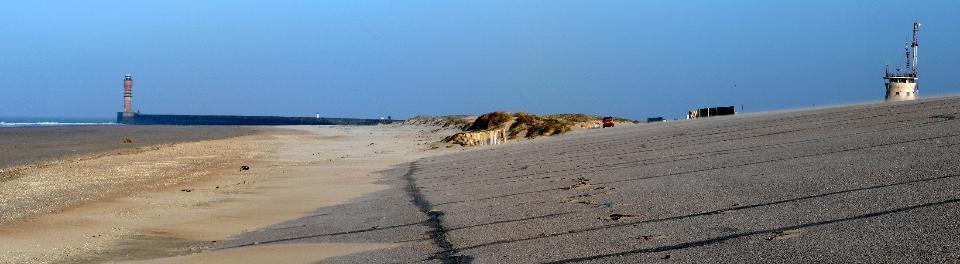
6 Beach and coastal dunes Asphalt dike Photo : Ruz 2010 Photo : Ruz 2005 Plage du Clipon Digue du Break


7 Dunes du Clipon: Incipient and established foredune development Photo : Ruz 2009 Photo : Ruz 2005 Source: Tresca, 2013

8 One of the aim of this study was to test the efficiency of sand fences in order to enhance coastal dune development Source: Tresca, 2013


9 Source: Tresca, 2013 Most of them rapidly captured a large amount of sand, especially sand fences erected well above the highest water levels
 they are opportunistic dunes, resulting from unintended human actions. On the dike, «coastal» dunes also naturally developped.")
10 Landward slope dunes Dike crest dunes Basin edge dunes Dike toe dunes Several types of dunes were identified. According to Nordstrom ans Arens (1988) they are opportunistic dunes, resulting from unintended human actions. On the dike, «coastal» dunes also naturally developped. The «digue du Braek» was built in 1963, and in 1988 dunes were covering an area of 7900m².By 2009, the cumulative area of dunes was reaching m². Source : Tresca, 2013

11 Sand accumulation updrift the jetty allowed the formation of a wide upper beach and embryo dunes development at the toe of the dike Dike toe dunes formation m² in 1983 > m² in 2009 Source: Tresca, 2013 Orthophotoplan I2G PPIGE

12 Basin edge dunes Under direct onshore winds, aeolian sand transport from the upper beach to the lee side of the dike resulted in the formation of what we called «basin edge dunes» Dunes de bordure de bassin Source: Tresca, 2013
13 Landward slope dunes Dunes de revers de digue Source: Tresca, 2013

14 (Clichés, Tresca, 28/07/2010) Here dune formation was initiated by Ammophila arenaria germination in numerous cracks, parallel to the dike slope. Vegetation growth was possible as, beneath the asphalt coating, the core of the dike is sandy. Vegetation trapped sand wind-blown from the adjacent sandy beach, resulting in the formation of parallel lines of embryo dunes along cracks. Sand then continues to accumulate and progressively embryo dunes coalesced resulting in the formation of continuous dunes covering the landward face of the dike (Tresca et al., 2014).
15 Dike crest dunes In the central part of the dike, dike landward slope dunes developed and reached the crest of the dike forming a ridge of 1 km long that covered the dike crest.they exceed 2 m above the dike crest elevation and are well stabilised by marram grass. Their morphology is quite similar to a foredune ridge. Dunes de sommet de digue Source: Tresca, 2013


16 Sand transfer from the seaward to the landward face of the dike is still active and requires costly dredging and removal operations. In 2010, for example, m 3 of sand was removed from a 500 m long road section at the landward toe of the dike (Tresca, 2013).
, and behind the dike-toe dune deflation corridors (D5 D6).")
17 Sand fences were erected on the dike in order to limit sand drifting. The most efficient fences were the fences installed close to a sand source, at the beach-dike contact (D1), and behind the dike-toe dune deflation corridors (D5 D6). Less efficient fences were synthetic mesh and wooden slats installed mid-slope on the seaward face of the dike. Source : Tresca, 2013

18 Cakile maritima (A et B) and Eryngium campestre (B) (Tresca 28/07/2010) Naturally developing dunes on harbour infrastructures could help to improve the diversity of landscapes along such human-altered shorelines. In Dunkirk seaport, dune development on the dike favoured natural development of protected species like Eryngium campestre. Furthermore, in a context of climate change inducing sea level rise, dune development on the crest of a sea dike can act as a buffer during storm surges and prevent dike overtopping by storm waves. These experiments will enable the Port of Dunkirk to build a management plan of its shoreline, in order to preserve the diversity of landscapes, habitats and species and meanwhile, to control sand invasion on the dike and reduce costly sand removal operations.


19 Photo : Ruz 2014 Photo : Ruz 2014 These results will also help in coastal dune rehabilitation, after the construction of a gas terminal. The Dunkirk LNG terminal will have an annual regasification capacity of 13 billion m 3 of gas, representing around 20% of France and Belgium's annual natural gas consumption. Photo : Ruz 2014 Source: DKLNG, avril 2014
20
Identifying Forcing Conditions Responsible for Foredune Erosion on the Northern Coast of France
 Journal of Coastal Research SI 56 356-360 ICS2009 (Proceedings) Portugal ISSN 0749-0258 Identifying Forcing Conditions Responsible for Foredune Erosion on the Northern Coast of France M-H. Ruz, A. Héquette
Dunes Growth Estimation for Coastal Protection
 Dunes Growth Estimation for Coastal Protection Muhammad Zikra Department of Ocean Engineering, Faculty of Marine Technology, ITS, Kampus ITS Keputih Sukolilo, Surabaya 60111 Abstract: This paper describes
SHORELINE AND BEACH PROCESSES: PART 2. Implications for Coastal Engineering
 SHORELINE AND BEACH PROCESSES: PART 2 Implications for Coastal Engineering Objectives of the lecture: Part 2 Show examples of coastal engineering Discuss the practical difficulties of ocean engineering
Patrick Hesp. Department of Geography and Anthropology, Louisiana State University
 Patrick Hesp Department of Geography and Anthropology, Louisiana State University Incipient ( embryo ) Foredunes - new, or developing foredunes formed by aeolian sand deposition within pioneer plant communities
Map 10: Ayrshire Coast: Barassie to Prestwick North Map Content Descriptions
 Map 10: Ayrshire Coast: Barassie to Prestwick North Map Content Descriptions 1. Built Heritage and Archaeology A total of thirteen sites were recorded in the area covered by Map 10. Of these nine were
MEMORANDUM FOR SWG
 MEMORANDUM FOR SWG-2007-1623 Subject: Jurisdictional Determination (JD) for SWG-2007-1623 on Interdunal Wetlands Adjacent to Traditional Navigable Waters (TNWs) Summary The U.S. Environmental Protection
Scenarios for the NI coast in the 21 st Century
 Scenarios for the NI coast in the 21 st Century Prof Julian Orford Geography, Archaeology & Palaeoecology Queen s University, Belfast Challenging perspective Living by the coast is good for your health!
2.2.7 Backbarrier flats
 FIGURE 24. VERTICAL PHOTOGRAPH SHOWING THE DEVELOPMENT OF SMALL PARABOLIC DUNES FROM BLOWOUTS IN A LARGE RELICT FOREDUNE NORTHWEST OF HUNTER'S CREEK. PHOTOGRAPH COURTESY OF CAR'T'ER HOLT HARVEY FORESTS
TECHNIQUES FOR ASSESSING COASTAL HAZARD AREAS FOR THE GISBORNE DISTRICT COAST
 TECHNIQUES FOR ASSESSING COASTAL HAZARD AREAS FOR THE GISBORNE DISTRICT COAST July 1994 C.R. 1994/12 Jeremy G Gibb 2009 All rights reserved. This work is entitled to the full protection given by the Copyright
Phillip Island Nature Parks Coastal Process Study 8 October 2014
 Phillip Island Nature Parks Coastal Process Study 8 October 2014 Project Overview Coastal Geology Basaltic and fragmented lavas, granite at Pyramid Rock and Cape Woolamai Weathered basalt (>10m thick)
Protecting the Storm Damage Prevention and Flood Control Interests of Coastal Resource Areas
 Protecting the Storm Damage Prevention and Flood Control Interests of Coastal Resource Areas Presented by: Massachusetts Department of Environmental Protection & Massachusetts Office of Coastal Zone Management
Connecticut Coastal Management Program
 Connecticut Coastal Management Program Fact Sheet for SHORELINE FLOOD AND EROSION CONTROL STRUCTURES What are Shoreline Flood and Erosion Control Structures? The Connecticut General Statutes (CGS) define
26 Coastal erosion and accretion
 26 Coastal erosion and accretion 26.1 Rate of erosion and accretion 26.2 Length of protected coastline 26.3 Volume of sand nourishment Fig. 26.1: Coastline dynamics of the South East Baltic region Key
Using LiDAR Topographic Data for Identifying Coastal Areas of Northern France Vulnerable to Sea-Level Rise
 Journal of Coastal Research SI 75 1067-1071 Coconut Creek, Florida 2016 Using LiDAR Topographic Data for Identifying Coastal Areas of Northern France Vulnerable to Sea-Level Rise Adrien Crapoulet, Arnaud
Coastal Sediment Transport
 Coastal & Marine Coastal Sediment Transport Mazen Abualtayef Assistant Prof., IUG, Palestine Sediment Transport Sediment is any particulate matter that can be transported by fluid flow and which eventually
DIVISION OF COASTAL MANAGEMENT TO STUDY CURRENT LONG-TERM EROSION RATES ADJACENT TO TERMINAL GROINS
 DIVISION OF COASTAL MANAGEMENT TO STUDY CURRENT LONG-TERM EROSION RATES ADJACENT TO TERMINAL GROINS North Carolina Department of Environmental Quality Division of Coastal Management February 22, 2018 N.
Environment Bay of Plenty Ohope Beach system
 Environment Bay of Plenty 7 5. Ohope Beach system Environmental Publication 27/ NERMN Beach Profile Monitoring Environment Bay of Plenty 5..1 Ohope Spit (CCS 9) Discussion The site is located 2m to the
AN EXPERIMENTAL STUDY ON SAND DUNE SEDIMENT TRANSPORT DUE TO TSUNAMI OVERWASH. K M Ahtesham Hossain Raju 1 and Shinji Sato 2
 AN EXPERIMENTAL STUDY ON SAND DUNE SEDIMENT TRANSPORT DUE TO TSUNAMI OVERWASH K M Ahtesham Hossain Raju 1 and Shinji Sato 2 Response of sand dune when overwashed by tsunami or storm surge, is investigated
The Marine Environment
 The Marine Environment SECTION 16.1 Shoreline Features In your textbook, read about erosional landforms, beaches, estuaries, longshore currents, and rip currents. For each statement below, write true or
Geol 117 Lecture 18 Beaches & Coastlines. I. Types of Coastlines A. Definition:
 I. Types of Coastlines A. Definition: 1. Shore = narrow zone where ocean meets land (e.g. beach) 2. Coast is a broad area where both ocean and land processes act a. Includes onshore marshes, dunes, sea
Section 2.1 Ocean Basins. - Has helped determine where ocean basins are located. - Tectonic plates move changing the position of the continents.
 Science 8 Unit 1: Water Systems on Earth Chapter 2: Oceans Control the Water Cycle Section 2.1 Ocean Basins Oceans are important because: 1. Primary water source for the water cycle 2. Control weather
Higher Geography Biosphere Vegetation Succession: Sand Dunes
 Higher Geography Biosphere Vegetation Succession: Sand Dunes A PowerPoint resource to accompany the posters available at: http://www.macaulay.ac.uk/soilposters/education_vegetation_6v2.pdf http://www.macaulay.ac.uk/soilposters/education_vegetation_7v2.pdf
The Marine Environment
 The Marine Environment SECTION 16.1 Shoreline Features In your textbook, read about erosional landforms, beaches, estuaries, longshore currents, and rip currents. For each statement below, write or. 1.
Short-term beach dune sand budgets on the north sea coast of France: Sand supply from shoreface to dunes, and the role of wind and fetch
 Geomorphology 81 (2006) 316 329 www.elsevier.com/locate/geomorph Short-term beach dune sand budgets on the north sea coast of France: Sand supply from shoreface to dunes, and the role of wind and fetch
Redcliffs Park Coastal inundation and coastal erosion
 48 Hereford Street Christchurch 8013 Attention: Deb Taylor Dear Deb 1 Introduction The (MoE) are looking to relocate Redcliffs School to a new school development at and are currently undertaking their
Map 9: Ayrshire Coast: Stevenston Pier to Barassie Map Content Descriptions
 Map 9: Ayrshire Coast: Stevenston Pier to Barassie Map Content Descriptions 1. Built Heritage and Archaeology A total of thirteen sites were recorded in the area covered by Map 9. Of these five were previously
Morphodynamics of the central Swina Gate Barrier foredunes (Polish coast) since 1995: a case study
 since 1995: a case study") Herrier J.-L., J. Mees,. Salman, J. Seys, H. Van Nieuwenhuyse and I. obbelaere (ds). 5. p. 19-3 Proceedings unes and stuaries 5 International onference on Nature Restoration Practices in uropean oastal
Herrier J.-L., J. Mees,. Salman, J. Seys, H. Van Nieuwenhuyse and I. obbelaere (ds). 5. p. 19-3 Proceedings unes and stuaries 5 International onference on Nature Restoration Practices in uropean oastal
Primer on Coastal Erosion And Habitat Creation
 2 nd Regional Conference Dredging, Beach Nourishment & Bird Conservation Primer on Coastal Erosion And Habitat Creation Timothy Kana Ph.D Source: Newsday 1962 Photo by Kelsey Aerials 1978 Source: U Mass
Controlling Processes That Change Land
 1 Name Date Controlling Processes That Change Land People try to control some of the processes that change land. To do this, people apply technology- the use of science to solve problems in everyday life.
GCSE 4242/02 GEOGRAPHY (Specification B) FOUNDATION TIER UNIT 2 SECTION B
 FOUNDATION TIER UNIT 2 SECTION B") Surname Centre Number Candidate Number Other Names 0 GCSE 4242/02 GEOGRAPHY (Specification B) FOUNDATION TIER UNIT 2 SECTION B S15-4242-02 P.M. WEDNESDAY, 3 June 2015 1 hour 30 minutes For s use Part Maximum
Surname Centre Number Candidate Number Other Names 0 GCSE 4242/02 GEOGRAPHY (Specification B) FOUNDATION TIER UNIT 2 SECTION B S15-4242-02 P.M. WEDNESDAY, 3 June 2015 1 hour 30 minutes For s use Part Maximum
Map Introduction: South Uist Map 1
 96 Map Introduction: Map This map section covers part of the south coast of, including the head of the causeway which links the island to Eriskay. It extends from South Glen Dale to Taobh a'caolas. There
Annual transport rates at two locations on the fore-slope.
 Sediment Transport by Currents Fore-slope Sediment transport rates and sediment concentrations were computed from the hydrodynamic model runs as well as from direct measurements of current velocities at
Chapter 7 Case study. Sand dune coastal environment: Studland Bay
 Sand dune coastal environment: Studland Bay Sand dunes are common features of low-lying stretches of coastline in the UK and elsewhere in the world. They form in places where there is a plentiful supply
Spiekeroog. A day of the Wilhelmshaven Excursion (KOL) Report by Michaela Erni, Reto Grischott, Marcel Nägeli and Gregor Zographos
 Report by Michaela Erni, Reto Grischott, Marcel Nägeli and Gregor Zographos") A day of the Wilhelmshaven Excursion (KOL) Report by Michaela Erni, Reto Grischott, Marcel Nägeli and Gregor Zographos D-Erdw, ETH Zurich, Switzerland 2010 1. Introduction is one of the seven East Frisian
A day of the Wilhelmshaven Excursion (KOL) Report by Michaela Erni, Reto Grischott, Marcel Nägeli and Gregor Zographos D-Erdw, ETH Zurich, Switzerland 2010 1. Introduction is one of the seven East Frisian
Coastal Processes and Shoreline Erosion on the Oregon Coast, Cascade Head to Cape Kiwanda
 State of Oregon Department of Geology and Mineral Industries Vicki S. McConnell, State Geologist Open File Report OFR O-04-11 Coastal Processes and Shoreline Erosion on the Oregon Coast, Cascade Head to
Graduate School of Civil and Ecological Engineering, I-Shou University, Kaohsiung, Taiwan, R.O.C.
 Journal of Civil Engineering and Architecture 10 (2016) 1297-1303 doi: 10.17265/1934-7359/2016.11.011 D DAVID PUBLISHING Ho-Shong Hou Graduate School of Civil and Ecological Engineering, I-Shou University,
OVERWASHED SEDIMENT INTO THE GAMO LAGOON IN NANAKITA RIVER MOUTH AND EFFECTIVENESS OF THE OVERWASH PREVENTION CONSTRUCTION
 東北地域災害科学研究第 6 巻 (010) 191 OVERWASHED SEDIMENT INTO THE GAMO LAGOON IN NANAKITA RIVER MOUTH AND EFFECTIVENESS OF THE OVERWASH PREVENTION CONSTRUCTION ABSTRACT Xuan Tinh Nguyen 1, Ryutaro Hirao, Hitoshi
Shoreline and Climate Change Adaptation Alternatives for The Letter Parcel, Bolinas Lagoon
 Shoreline and Climate Change Adaptation Alternatives for The Letter Parcel, Bolinas Lagoon Scenic shoreline vista of Bolinas Lagoon and ridges, from Letter Parcel, March 2016 Peter Baye, Coastal Ecologist
ABSTRACT. KEY WORDS: Forelands, wave propagation, wave transmission, on site measurement, physical modelling, numerical modelling.
 Auszug aus: Proc. of the th Int. Conf. Offshore and Polar Engineering, Kitakyushu, Japan, (im Druck) Wave Transmission over Natural and Artificial Forelands Dr.-Ing. Nicole von Lieberman, Dipl.-Phys. Dipl.-Ing.
Seaton to Seaton Hole SUMMARY OF PREFERRED PLAN RECOMMENDATIONS AND JUSTIFICATION
 Location reference: Policy Unit reference: Plan: Seaton to Seaton Hole 6a29 and 6a30 SUMMARY OF PREFERRED PLAN RECOMMENDATIONS AND JUSTIFICATION The large number of properties and assets at risk in the
SHORT AND LONG TERM IMPACTS OF THE CONSTRUCTION OF COAST DEFENCES ON COASTAL EROSION
 SHORT AND LONG TERM IMPACTS OF THE CONSTRUCTION OF COAST DEFENCES ON COASTAL EROSION by 1, Kevin Burgess 1 and Ben Hamer 1 1 Halcrow Group Ltd, Burderop Park, Swindon, Wiltshire, SN4 0QD Abstract: Significant
SHORELINE MANAGEMENT PLAN FOR OWEN ANCHORAGE AND COCKBURN SOUND SHORELINE MONITORING PLAN
 SHORELINE MANAGEMENT PLAN FOR OWEN ANCHORAGE AND COCKBURN SOUND SHORELINE MONITORING PLAN CHAPTER EIGHT OF DOCUMENT: LONG-TERM SHELLSAND DREDGING, OWEN ANCHORAGE ENVIRONMENTAL MANAGEMENT PROGRAMME JUNE
PEKA PEKA FIVE YEAR RESTORATION PLAN
 PEKA PEKA FIVE YEAR RESTORATION PLAN BACKGROUND Pekapeka is located on the Kapiti Coast between Te Horo in the north and Waikanae to the south. The dune area is a Kapiti Coast District Council (KCDC) reserve.
Coastal Management on the Isle of Wight
 Coastal Management on the Isle of Wight Setting the scene The Isle of Wight has 65 miles of spectacular coastline, 28 miles of which are designated Heritage Coast. This varied coastline is one of the Island
MISSISSIPPI COASTAL IMPROVEMENTS
 MISSISSIPPI COASTAL IMPROVEMENTS PROGRAM (MsCIP) Comprehensive Barrier 237 27 200 237 27 200 Island 237 Restoration 27 200 Plan 80 9 27 252 74.59 255 255 255 0 0 0 63 63 63 3 32 22 239 65 53 0 35 20 2
HOTSPOT STATEMENT. Sainte-Marie. Languedoc-Roussillon. France. Part of the RESPONSE LIFE-Environment Project 2006
 HOTSPOT STATEMENT Hazard and risk potential, Scale of the problem, When the Part of the RESPONSE LIFE-Environment Project 2006 For more information: www.coastalwight.gov.uk /response.html Purpose of this
Regional Sediment Management
 Regional Sediment Management Linda S. Lillycrop Program Manager Coastal Engineer US Army Engineer Research and Development Center Coastal and Hydraulics Laboratory Q AVG Coastal Resilience: The Environmental,
Summary Visualizations for Coastal Spatial Temporal Dynamics
 Summary Visualizations for Coastal Spatial Temporal Dynamics October 24 2011 Providence, RI Sidharth Thakur 1, Laura Tateosian 2, Helena Mitasova, Eric Hardin, and Margery Overton 1. sthakur@renci.org,
Recent Evolution of Culatra Island (Algarve Portugal)
") Recent Evolution of Culatra Island (Algarve Portugal) Tiago Garcia 1, Óscar Ferreira 2, Ana Matias 1 & João Alveirinho Dias 2 1 CIACOMAR, Universidade do Algarve, Av. 16 de Junho, s/n, 8700-311, Olhão,
Recent Evolution of Culatra Island (Algarve Portugal) Tiago Garcia 1, Óscar Ferreira 2, Ana Matias 1 & João Alveirinho Dias 2 1 CIACOMAR, Universidade do Algarve, Av. 16 de Junho, s/n, 8700-311, Olhão,
Built Heritage & Archaeology Crown copyright. All rights reserved. Historic Scotland Licence No [2007] a
![Built Heritage & Archaeology Crown copyright. All rights reserved. Historic Scotland Licence No [2007] a](/thumbs/92/110316004.jpg "Built Heritage & Archaeology Crown copyright. All rights reserved. Historic Scotland Licence No [2007] a") : Tràigh an Tobair Fhuair to Meall Lamalum This map section stretches along s west coast from Tràigh an Tobair Fhuair to Meall Lamalum. The entire coastline comprises a rock platform, with the exception
: Tràigh an Tobair Fhuair to Meall Lamalum This map section stretches along s west coast from Tràigh an Tobair Fhuair to Meall Lamalum. The entire coastline comprises a rock platform, with the exception
Storm Induced Coastal Erosion for Flood Insurance Studies and Forecasting Coastal Flood Damage Impacts: Erosion, Runup & Overtopping
 Storm Induced Coastal Erosion for Flood Insurance Studies and Forecasting Coastal Flood Damage Impacts: Erosion, Runup & Overtopping Jeff Gangai- Dewberry Tucker Mahoney FEMA HQ Introduction Background
Hard Engineering: Lyme Regis
 Hard Engineering: Lyme Regis By The British Geographer Situation Lyme Regis, with a population of 4400 is located in the centre of the Heritage Jurassic Coast in Dorset, South England. It is exposed to
Map 2: Cowal Peninsula: Lazaretto Point to Dunoon Harbour North Map Content Descriptions
 Map 2: Cowal Peninsula: Lazaretto Point to Dunoon Harbour North Map Content Descriptions 1. Built Heritage and Archaeology A total of thirteen sites were recorded in the area covered by Map 2. Of these
Recent Evolution of Culatra Island (Algarve Portugal)
") . EUROCOAST / EUCC, Porto Portugal Ed. EUROCOAST Portugal, ISBN 972-8558-09-0 Recent Evolution of Culatra Island (Algarve Portugal) Tiago Garcia 1, Óscar Ferreira 2, Ana Matias 1 & João Alveirinho Dias
. EUROCOAST / EUCC, Porto Portugal Ed. EUROCOAST Portugal, ISBN 972-8558-09-0 Recent Evolution of Culatra Island (Algarve Portugal) Tiago Garcia 1, Óscar Ferreira 2, Ana Matias 1 & João Alveirinho Dias
Erosion Information Paper - Barrow, Alaska Current as of September 14, 2007
 U.S. Army Corps of Engineers ALASKA BASELINE EROSION ASSESSMENT Erosion Information Paper - Barrow, Alaska Current as of September 14, 2007 Community Information Barrow (BARE-row, a.k.a. Ukpeagvik), population
3.0 ROBERTS BANK TIDAL FLAT MORPHOLOGY
 Vancouver Port Authority Northwest Hydraulic Consultants Ltd. /Triton Consultants Ltd. Roberts Bank Container Expansion File: 33863 Coastal Geomorphology Study - 19 - November 2004 3.0 ROBERTS BANK TIDAL
Land subsidence at the Kujukuri Plain in Chiba Prefecture, Japan: evaluation and monitoring environmental impacts
 Land Subsidence, Associated Hazards and the Role of Natural Resources Development (Proceedings of EISOLS 2010, Querétaro, Mexico, 17 22 October 2010). IAHS Publ. 339, 2010. 293 Land subsidence at the Kujukuri
How does erosion happen?
 How does erosion happen? By National Geographic, adapted by Newsela staff on 10.03.17 Word Count 682 Level 830L These rock formations, in Bryce Canyon National Park, Utah, are called hoodoos. Although
Coastal Processes 101. Greg Berman (Woods Hole Sea Grant & Cape Cod Cooperative Extension)
") Coastal Processes 101 Greg Berman (Woods Hole Sea Grant & Cape Cod Cooperative Extension) January 23, 2019 Coastal Processes 101 Outline: ~30 min talk Coastal Processes What is Erosion? Value of the Ecosystem
Coastal Processes 101 Greg Berman (Woods Hole Sea Grant & Cape Cod Cooperative Extension) January 23, 2019 Coastal Processes 101 Outline: ~30 min talk Coastal Processes What is Erosion? Value of the Ecosystem
2/23/2009. Visualizing Earth Science. Chapter Overview. Deserts and Drylands. Glaciers and Ice Sheets
 Visualizing Earth Science By Z. Merali and B. F. Skinner Chapter 6 Deserts, Glaciers and Ice Sheets Chapter Overview Deserts and Drylands Glaciers and Ice Sheets Deserts Geography Categorization of deserts
MANAGING COASTAL BIOME INTERFACES
 MANAGING COASTAL BIOME INTERFACES A Discussion Paper ROBERT BRUCE JEFFREY DOLAN HAYDEN HEYWOOD CHARLOTTESVILLE, VIRGINIA U.S.A. SEPTEMBER, 1975 UNESCO / UNEP PROJECT No. 0605 "74 "002 MANAGING COASTAL
Newsletter # 2. Pilot sites in Greece. December 2018
 A HarmonizEd framework to Mitigate coastal EroSion promoting ICZM protocol implementation Newsletter # 2 December 2018 View of a beach in Ammolofi ( Paggaio Municipality ) Pilot sites in Greece 1. Name
East Head, West Wittering and Cakeham: Interpretation of beach changes
 East Head, West Wittering and Cakeham: Interpretation of beach changes 2004-09 Draft Report to: Chichester District Council and East Head Coastal Issues Advisory Group Malcolm Bray University of Portsmouth
Sediment Management in the Coastal Bays
 Sediment Management in the Coastal Bays Introduction Need for ecosystem view of sediment management in Coastal Bays Island loss and restoration Navigation needs Habitat Trade offs Living Shoreline Requirements
What are the issues?
 Water Quality along Lake Huron What are the issues? Lake Huron Water Quality Algal fouling Irregular, less frequent, less widespread, but some significant local events Influences Tributaries contribute;
Plate 51. Site 035. Collection of remains. Scale is in cm. Plate 50. Site 034. Collection of remains. Scale is in cm
 Plate 48. Site 033. View facing north west Plate 49. Site 034. View facing north Pottery Pottery Ostrich eggshell Plate 50. Site 034. Collection of remains. Scale is in cm Plate 51. Site 035. Collection
Coastal Systems and Landscapes 3 days
 AS Level Geography WJEC Coastal Systems and Landscapes 3 days This course is for Welsh schools. This in-depth course prepares students for the physical fieldwork focusing on the Coastal option, for Section
MID-TERM CONFERENCE CREST
 MID-TERM CONFERENCE CREST 23 November 2017 Innovation in Coastal Monitoring Alain De Wulf (Ugent, Geography Dept.) Innovation in coastal monitoring Outline Why? How? What (tools do we use to assess)? Conclusion
Temporal and spatial scales of the features and processes forming the Polish Baltic Sea coast
 The coasts of the North Sea and the Baltic Sea under climate change - synthesis of German and Polish strategies for development and prediction, Hamburg, 11 12 October, 2016, German Polish Seminar Temporal
MAINTENANCE DREDGE BENTHIC ASSESSMENT SUNSET POINT FARM LLC LONG POINT KEY MONROE COUNTY, FLORIDA. Prepared by:
 MAINTENANCE DREDGE BENTHIC ASSESSMENT SUNSET POINT FARM LLC LONG POINT KEY MONROE COUNTY, FLORIDA Prepared by: December 11, 2016 INTRODUCTION The owners of the Sunset Point Farms LLC, located on the northern
The Erosion Problem: Perspectives. Physical
 Greg Berman The Erosion Problem: Perspectives Physical Education Regulation The Erosion Problem: Physical Perspectives What is a hotspot? Erosion Rate / Vulnerability / Frame of Reference Sandwich Town
Coastal Environment. Introduction. 4.1 Coastal Environment. Extent of Coastal Environment
 4 The primary objective (set out in Chapter 2) to be implemented by this Chapter is Objective 2.4 ; the following objectives are also relevant due to the objectives integrated nature: 2.1 Tāngata whenua
Map 12: Ayrshire Coast: Doonfoot Beach to Dunure Map Content Descriptions
 Map 12: Ayrshire Coast: Doonfoot Beach to Dunure Map Content Descriptions 1. Built Heritage and Archaeology A total of twenty three sites were located in the area covered by Map 12. Of these seventeen
2nd Grade. Wind, Water and Land.
 1 2nd Grade Wind, Water and Land 2015 11 23 www.njctl.org 2 Wind, Water and Land What is Wind? Wind Erosion Preventing Wind Erosion Water Erosion Sudden Water Erosion Preventing Water Erosion Landforms
COASTAL DYNAMICS VIRTUAL FIELD TRIP, NORTHEAST FLORIDA. Joann Mossa Department of Geography University of Florida
 COASTAL DYNAMICS VIRTUAL FIELD TRIP, NORTHEAST FLORIDA Joann Mossa Department of Geography University of Florida WHERE ARE WE GOING? In NE Florida (Flagler and St. Johns County, south of St. Augustine),
Dune habitat conservation status assessment review
 Annotated document key - Item Summary Emphasis Dune habitat conservation status assessment review CCW carried out an assessment of the condition of the dune habitats of the SAC in the summer of 2005 and
Are Living Shorelines Effective for Erosion Management on North Atlantic Coastlines?
 Are Living Shorelines Effective for Erosion Management on North Atlantic Coastlines? By Kirsten Ellis, BSc, MSc candidate Supervisor: Jeremy Lundholm, PhD Committee: Danika Van Proosdij, PhD and Rosmarie
Australian Coastal Councils Conference
 Australian Coastal Councils Conference 11 March 2015 Estimating Future Coastal Inundation and Erosion Hazards Dr Andrew McCowan Dr Christine Lauchlan-Arrowsmith Warwick Bishop Background Victorian Future
Defining the Limit of Regulated Areas. C.1 Defining the River or Stream Flood Hazard 138. C.2 Defining the River or Stream Erosion Hazard 139
 C.1 Defining the River or Stream Flood Hazard 138 C.2 Defining the River or Stream Erosion Hazard 139 C.3 Defining Watercourses 141 C.4 Defining the Lake Ontario Shoreline Flood, Erosion and Dynamic Beach
Weathering, Erosion, and Deposition Guided Notes
 1. Weathering, Erosion, and Deposition 2. Outline Section 1: Weathering Section 2: Erosion Section 3: Deposition Section 4: Case Study Weathering, Erosion, and Deposition Guided Notes 3. Section 1: Weathering
Hurricanes and Storm Surge : Before coming to lab, visit the following web site:
 Geol 108 Lab #7 Week of October 15-19, 2012 Coastal Studies Hurricanes and Storm Surge : Before coming to lab, visit the following web site: http://www.usatoday.com/graphics/weather/gra/gsurge/flash.htm
The Urban Sea and Coastal Zone Management
 The Urban Sea and Coastal Zone Management David NEALE, Trinidad and Tobago Key words: hydrography, Caribbean, coastal zone management, land use. SUMMARY Within the coastal zone of Eastern Caribbean States,
The problem of the use of ambiguous terms in Tasmanian coastal planning policy documents for defining appropriate coastal development zones
 The problem of the use of ambiguous terms in Tasmanian coastal planning policy documents for defining appropriate coastal development zones Chris Sharples, May 2012 Introduction Coastal planning and policy
Coastal Flood Risk Study Project for East Coast Central Florida Study Area
 Coastal Flood Risk Study Project for East Coast Central Florida Study Area St Lucie County, Florida Flood Risk Review Meeting March 28, 2017 Introductions Risk MAP Project Team FEMA Region IV BakerAECOM,
Science EOG Review: Landforms
 Mathematician Science EOG Review: Landforms Vocabulary Definition Term canyon deep, large, V- shaped valley formed by a river over millions of years of erosion; sometimes called gorges (example: Linville
Whiskey Island Marsh Creation Rolling with the Punches
 Whiskey Island Marsh Creation Rolling with the Punches Santiago Alfageme, M&N Jerry Carroll, LADNR Brad Miller, LADNR Project Location Historic Island Retreat Previous Restoration Project Whiskey Island
Scotland s centre of expertise for waters. Dynamic Coast - National Coastal Change Assessment: Defence Asset Database
 Scotland s centre of expertise for waters Dynamic Coast - National Coastal Change Assessment: Defence Asset Database Scotland s centre of expertise for waters Published by CREW Scotland s Centre of Expertise
Wetland attenuation of Hurricane Rita s storm surge
 Wetland attenuation of Hurricane Rita s storm surge Pat Fitzpatrick, Yee Lau, Yongzuo Li, Nam Tran, Chris Hill, and Suzanne Shean Geosystems Research Institute, Mississippi State University Sponsors: NOAA
Active Coastal Processes in the Lubec Embayment
 The Lubec Embayment Maine Geologic Facts and Localities August, 1998 Active Coastal Processes in the Lubec Embayment 44 49 50.51 N, 66 59 34.16 W Text by Joseph T. Kelley, Department of Agriculture, Conservation
1.0 INSPECTION ANNUAL INSPECTION, JUNE 29, 2011 CARMACKS COPPER PROJECT, CARMACKS, YUKON. Dear Mr. West-Sells,
 Doc. No. 162 Rev. 0 Mr. Paul West-Sells President & Chief Operating Officer Western Copper Corporation 2060-1111 West Georgia Street Vancouver, BC V6E 4M3 ANNUAL INSPECTION, JUNE 29, 2011 CARMACKS COPPER
Coastal Inlets Research Program US Army Corps of Engineers Engineering Research and Development Center
 Coastal Inlets Research Program US Army Corps of Engineers Engineering Research and Development Center Site of Moriches Inlet Nov. 1951 Julie Dean Rosati and Nicholas C. Kraus, CIRP Program Manager Shinnecock
CHAPTER FIVE: THE LOWER MISSISSIPPI REGION AND PLAQUEMINES PARISH
 CHAPTER FIVE: THE LOWER MISSISSIPPI REGION AND PLAQUEMINES PARISH 5.1 Overview Plaquemines Parish is the area where the last portion of the Mississippi River flows out into the Gulf of Mexico (see Figures
KEYWORDS: erosion shoreline change nourishment community issues
 UNC Coastal Studies Institute 1 TITLE: Sand, Soil, Sediment Selection for Beach Nourishment KEYWORDS: erosion shoreline change nourishment community issues ABSTRACT: North Carolina s barrier islands are
Holderness Erosion and Evolution of the Spurn Peninsula
 Holderness Erosion and Evolution of the Spurn Peninsula Prof. Ken Pye and Dr. Simon Blott Kenneth Pye Associates Ltd. Outline of the Presentation Overview of historical erosion trends Effects of coast
Supplemental Slides. Shore: Junction of Land & Water. Junction of Land & Water. Sea Level Variations. Shore vs. Coast. Sea Level Variations
 Shore: Junction of Land & Water Supplemental Slides Sediments come off land Most get dumped at the beach Sediment interacts with ocean waves and currents Junction of Land & Water Features: Breaking waves,
Shore: Junction of Land & Water. Sediments come off land Most get dumped at the beach Sediment interacts with ocean waves and currents
 Shore: Junction of Land & Water Supplemental Slides Sediments come off land Most get dumped at the beach Sediment interacts with ocean waves and currents Junction of Land & Water Features: Breaking waves,
Kamburu Faru Boatu Urunu Faru Velaa Faru Dhakandhoo Mendhoo Funadhoo
 IG Working Group REEForm Reef and reef landform responses to environmental and climatic change Report from Research Expedition, Maldives, 29 th June to 13 th July 2011 Participants: hris Perry (Manchester
BYPASS IN GROYNE FIELDS: CASE STUDY ALONG THE LOBITO SPIT
 BYPASS IN GROYNE FIELDS: CASE STUDY ALONG THE LOBITO SPIT Sten Esbjørn Kristensen 1, Nils Drønen 2, Rolf Deigaard 3, Berry Elfrink 4 Abstract The Lobito spit, in Angola, is fronted by a groyne field along
Coastal flood protection systems Xynthia feedback experience. Case studies conclusion
 Revue Paralia, Volume 9 (2016) pp s04.1-s04.6 Keywords: Flood, Protection, System, Xynthia. Editions Paralia CFL Coastal flood protection systems Xynthia feedback experience. Case studies conclusion Marc
Eco-hydromorphic Characterization of the Louisiana Coastal Region Using Multiple Remotely Sensed Data Sources and Analyses
 National Wetlands Research Center Eco-hydromorphic Characterization of the Louisiana Coastal Region Using Multiple Remotely Sensed Data Sources and Analyses 1Holly Beck, 2 Brady Couvillion, 1 Nadine Trahan