Section 5 Source Water Protection
|
|
|
- Lora Sharp
- 6 years ago
- Views:
Transcription
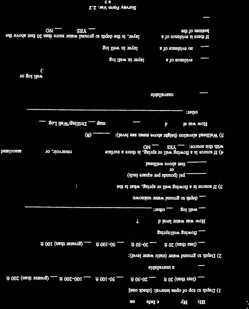
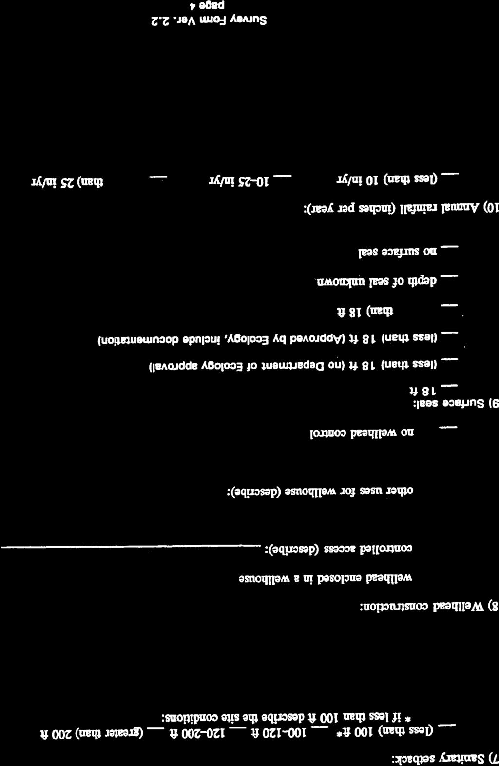
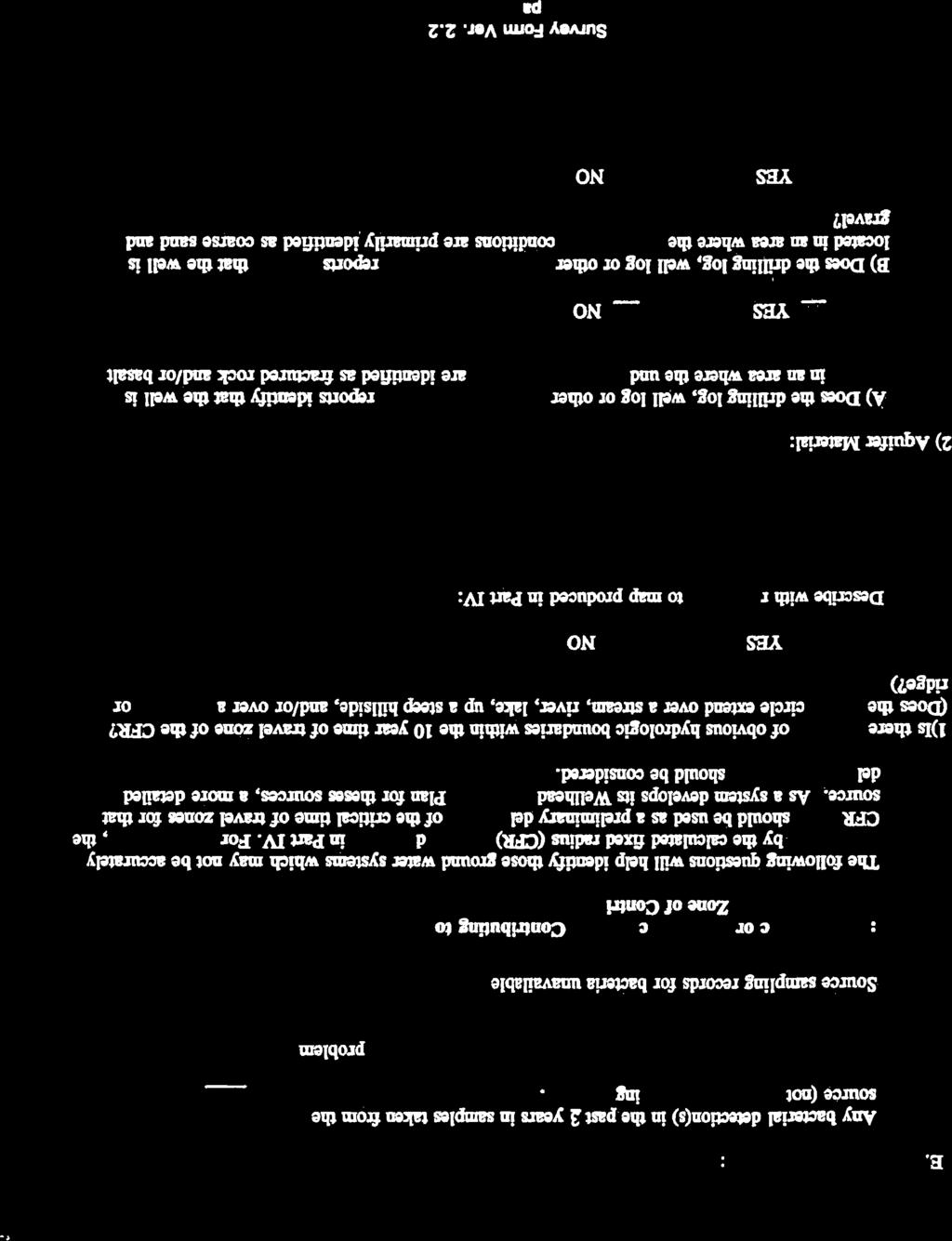
1 2017 WSP UPDATE Section 5 Source Water Protection As written in WAC , -668, and -690, Group A water systems are required to have source water protection. Source water protection is accomplished by identifying, monitoring, limiting and/or controlling all facilities and activities within the zone of contribution which may contaminate source water. The City of West Richland currently uses wells (No. 1, 2, 7, and 9) and an inter-tie with the City of Richland as its sources of supply. A new well (Well No. 11) has just been drilled. Since the City does not use surface water, a Watershed Control Program has not been implemented and is not included in this Water System Plan. The City has put into practice a Wellhead Protection Program (WHPP) for its well sources. This WHPP is included in Appendix O. Since the time the WHPP was written, Well No. 8 has been abandoned, and a new well (Well No. 10) has replaced it. The 2009 Water System Plan Update included an amendment to the WHPP for Well No. 8 and Well No. 10. Information from the 2009 Water System Plan along with information for Well No. 11 is included in an Addendum to the WHPP and is included in Appendix O. 5.1 Wellhead Protection Program All Group A Public Water Systems with ground water sources are required to develop a Wellhead Protection Program (WHPP). The goal of the WHPP is to identify potential threats of contamination and establish protective measures for local groundwater supplies. As a minimum the WHPP should include the following: A completed susceptibility assessment; A delineated wellhead protection area for each well, wellfield, or spring; An inventory within the wellhead protection area of all potential sources of contamination that may pose a threat to the water bearing zone (aquifer) utilized by the well, spring, or wellfield; Documentation that delineation and inventory findings are distributed to required entities; Contingency plans for providing alternate sources of drinking water in the event that contamination does occur; and Coordination with local emergency responders for appropriate spill/incident response measures. In 2002, a Wellhead Protection Plan was prepared for the City of West Richland. This document is included in Appendix O. Since the time the WHPP was prepared, well No. 11 has been drilled. This section serves as an addendum to the existing Wellhead Protection Plan, to account for these source alterations. Only the WHPP elements listed above, that have changes since the 2002 WHPP and the 2006 Addendum are included in this section. Included at the end of this section is the well formation log for Well # Groundwater Contamination Susceptibility Assessment Survey Forms The Department of Health has developed the Susceptibility Assessment Survey Form in order to determine a source s vulnerability of susceptibility to surface contamination. This serves as the first step in determining the wellhead protection area. This Assessment Survey Form is included for well #11 at the end of this section. It includes information on the well s construction, hydrogeologic information, calculated fixed head radius contaminant time of travel, water quality, and potential contamination sources. J-U-B Engineers/ /COWR WSP City of West Richland 90
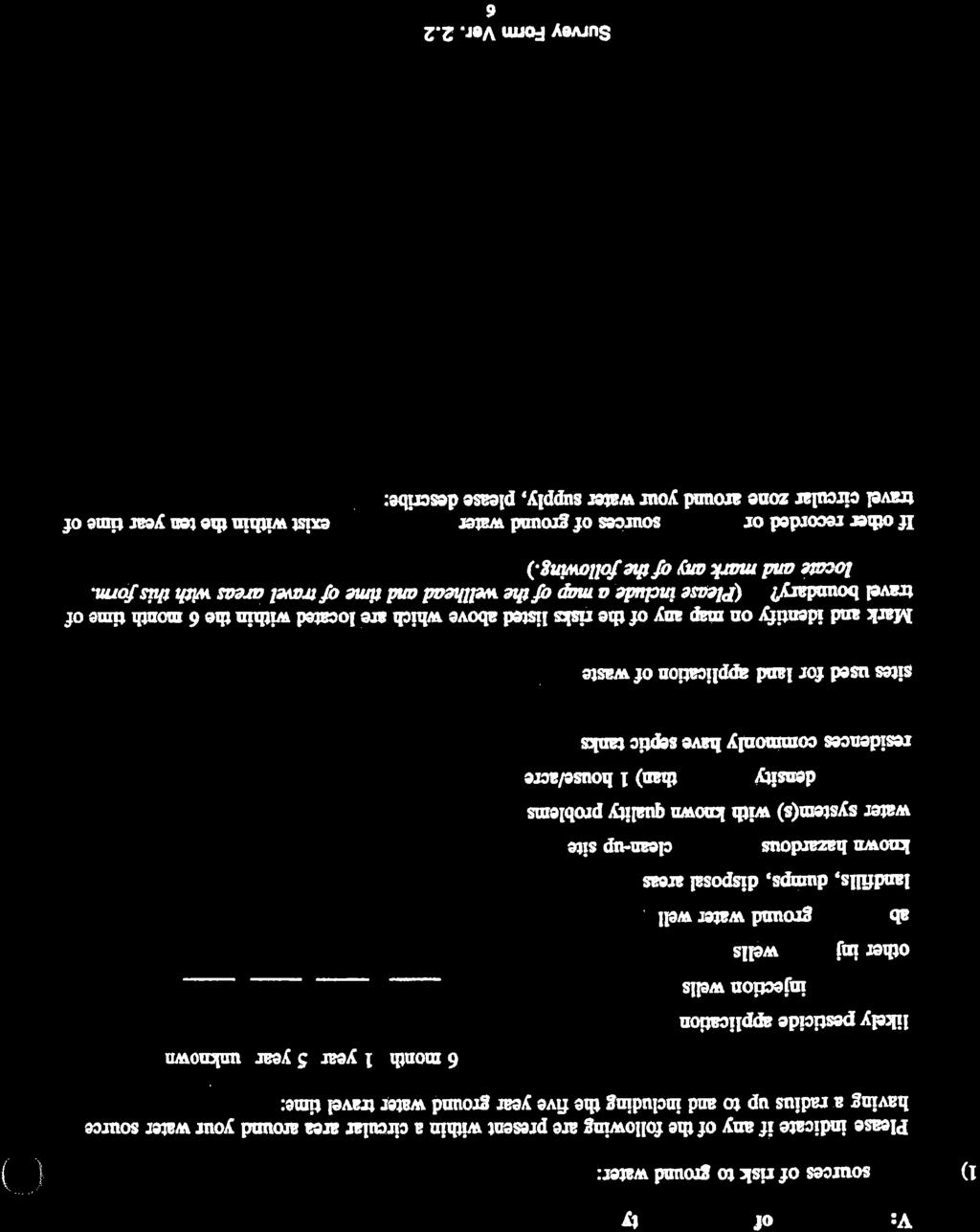
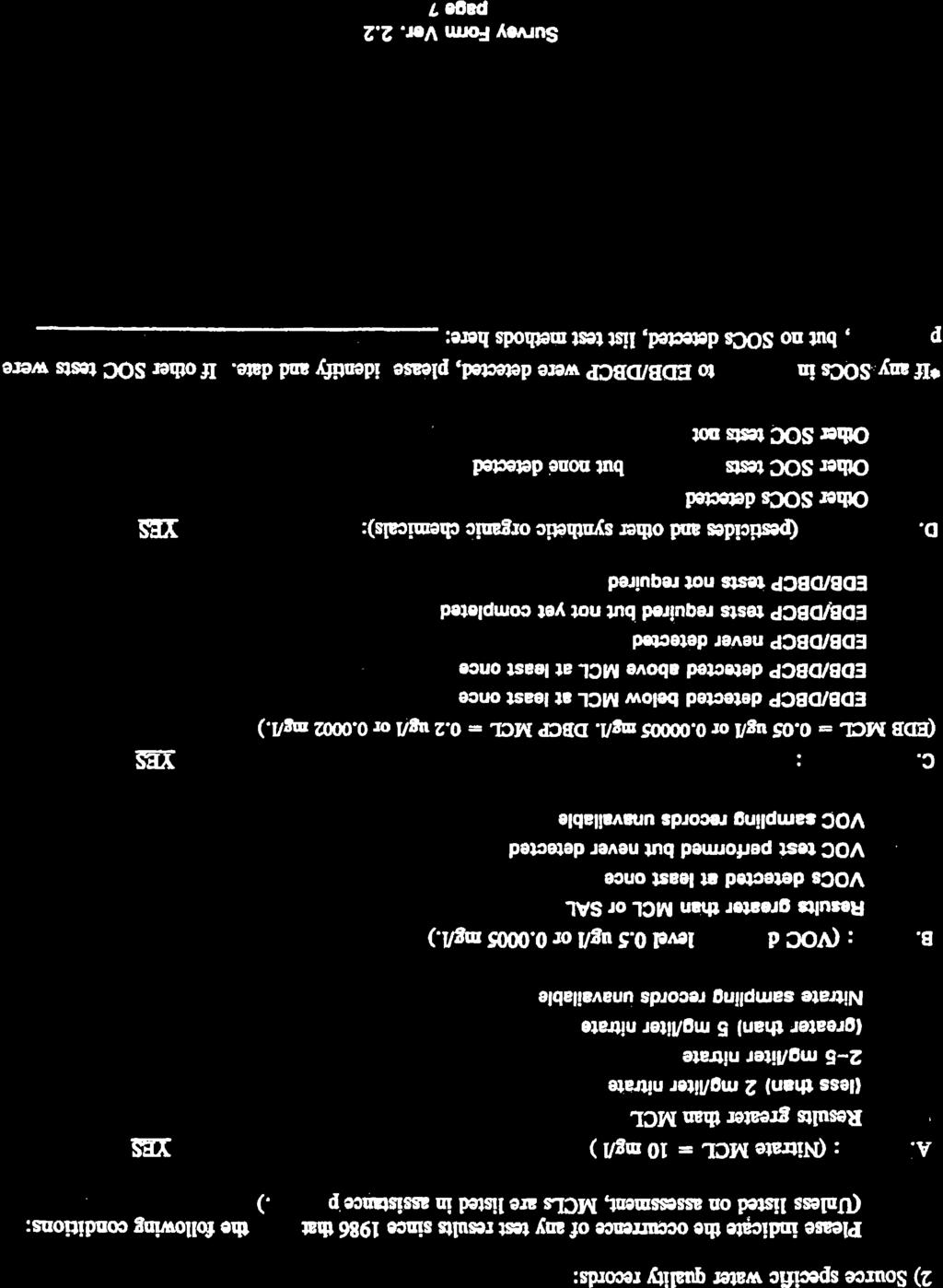
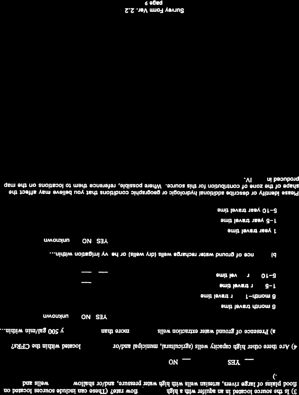
2 2017 WSP UPDATE Wellhead Protection Area As part of the Contamination Susceptibility Survey a Calculated Fixed Radius (CFR) was determined to estimate the ground water movement within a 6-month, 1-year, 5-year, and 10-year travel times. These travel time zones are shown for Well #11 in Figure 5-1. This method assumes that the travel time of contaminants in the ground will travel at the same speed as a particle of water. The CFR method also does not take into account the vertical movement of a water particle or contaminant from the land surface down to the aquifer. Since the infiltration rate is not taken into account, the rings of travel time shown in Figure 5-1 are conservative estimates Inventory of potential sources of contamination The 2002 inventory revealed a variety of potential contaminant sources located at thirty specific locations. Well #11 is located primarily in areas zoned as residential and agricultural. Most of the surrounding area is farmland. Possible sources of contaminants within the wellhead protection zone, as found in the susceptibility assessment survey form, are residential septic systems, and commercial fertilizers, herbicides, and pesticides applied on the farm. Residential areas within the protection zone of well #11 are not served by the municipal sewer system, and as such have private septic systems. However, given the depth of Well #11 (1,117 ft) and the surface casing depth of 745 ft, the total load of potential nitrogen and/or other contaminants from these sources is minimal. Once water quality samples are returned from the lab a summary will be given here. The complete Wellhead Protection Program in Appendix O, contains a complete inventory of potential sources of contamination for all wells. It also lists how the risk assessment for each source was determined. The risk assessments of possible contaminants found in the protection zone of well #11 are shown in Table 5.1. Table 5.1 Well #11 Contaminant Risk Contaminant (Category No.) Irrigation/chem.. application-agriculture (IV-2) Septic systems throughout city (I-1) Overall Risk Medium Medium J-U-B Engineers/ /COWR WSP City of West Richland 91


3 2017 WSP UPDATE Figure 5-1 Well #11 Calculated Fixed Radius Time of Travel Notification of Contact Agencies and Owners-Operators Following the WDOH guidelines, all owners/operators of known or potential contaminants sources must be notified of their location within the wellhead protection boundaries. A sample notification letter along with all entities contacted is contained in the complete WHPP in Appendix O Contingency Plan As part of the Water System Plan the City of West Richland has analyzed the overall source and storage of the system. This analysis involved identification of the water systems sources as compared to its water right restrictions and demand of the system. An evaluation was also done for expansion options so that the system s capacity could meet water rights and availability. J-U-B Engineers/ /COWR WSP City of West Richland 92
4 2017 WSP UPDATE A detailed contingency plan is contained in the complete WHPP located in Appendix O. This contingency plan addresses the long term replacement of the current principal sources of supply, and the cost of developing the new source of supply Spill Response Plan The City s Spill Response Plan is included in the City s WHPP contained in Appendix O. J-U-B Engineers/ /COWR WSP City of West Richland 93


5

6
7
8

9
10

11
12
13
14

15 5/24/16 Screen-Liner Assembly West Richland Well 11 0' ground surface surface seal bottom: 24" csg & seal ' 24" casing formation seal 20" casing bottom: 20" csg & seal ' Reinforced J-receptor 16" casing top: 10" liner -640' 640 CG bottom: 16" casing -745' sand CG 750 depth drilled 20" nom dia - 779' screen CG amount of 10" screen 130 amount of 10"x.365 M&M pipe 347 total screen assy length pea gravel CG CG = Centering Guide 1024 CG screen CG sand 1095 CG 1090-bottom 1115 pea gravel depth drilled 16" nom dia ' 1117 screen CG NTS ~5-10' cement plug near the bottom bottom 2' is blank with angle cut
16 FM TO DESCRIPTION CITY OF WEST RICHLAND Well #11 Formation Log by Schneider Water Services Formation Pre-bid (actual) 0 2 Silt, sandy brown, medium, loose 2 14 Silt, brown fine, compacted Sand, brown and grey, medium-fine, some gravel, 2" minus Gravel, 2" minus Gravel, 2" minus, some cementation Gravel, 4" minus Hanford actual: Cobbles & boulders Formation Cobbles, boulders & some clay, brown, soft-medium Cobbles, 6" minus & sand, tan, medium Cobbles, boulders & some sand, dark grey, medium-fine Cobbles & sand, grey, medium Cobbles & sand, dark grey, medium-fine Basalt, dark grey, medium, some fractures Ice Harbor Member Claystone, grey, medium-hard & some basalt, grey, medium Clay, grey, medium Levey Interbed actual: Clay, sandy, grey, soft Clay, tan, soft, silty Basalt, black, soft, vesicular, broken Basalt, grey, hard, fractured Basalt, black, medium, fractured, broken, vesicular w/some claystone, green-gray Basalt, dark grey, medium-hard, fractured Elephant Mtn actual: Basalt, dark grey, hard, fractured w/some pyrite Basalt, dark grey, hard Basalt, grey, hard, fractured Basalt, black, soft, fractured, vesicular w/some claystone, blue green Claystone, green, hard Claystone, green, medium Rattlesnake Ridge Claystone, gray & green, firm to medium actual: Interbed Claystone, green, medium Claystone, tan, medium-hard Basalt, black, soft, fractured, vesicular Basalt, black & brown, fractured, soft Basalt, dark grey, hard Basalt, brown & dark grey, medium-hard, fractured, some vesicles Basalt, dark grey, hard Basalt, dark grey, hard, some fractures & claystone, grey Pomona Member Basalt, dark grey, hard, fractured w/some claystone/mineral, green Saddle Moutain actual: Basalt, dark grey, hard Basalt Basalt, dark grey, hard, some fractures Basalt, grey, medium-hard, some fractures & minerals Basalt, grey, medium, fractured, some minerals Basalt, dark grey, medium hard Basalt, dark grey, hard, fractured w/some siltstone, green Basalt, black, soft, fractured, broken, weathered w/siltstone, green Basalt, black, soft, fractured, broken, weathered w/siltstone, blue-grey Basalt Interbed actual: Basalt, brown-grey, soft, fractured, broken, weathered Basalt, dark grey, medium-soft, fractured, broken, weathered w/claystone, green Basalt, dark grey, medium, fractured, some vesicles w/claystone, green Basalt, dark grey, medium-hard, occasional fractures Esquatzel Member Basalt, dark grey, medium-hard actual: Saddle Mtn Basalt Basalt, grey, hard Basalt, dark grey, soft, broken w/some claystone, brown, sandy Claystone, green, medium-hard, silty Gravel, 1/4" minus Claystone, green, medium, silty 24" Casing 24" Casing to 118.5' 20" Casing 20" Casing to " Casing 16" Casing to 745' Page 1 of 2 SWL
17 FM TO DESCRIPTION CITY OF WEST RICHLAND Well #11 Formation Log by Schneider Water Services Formation Sand, grey, fine-medium heaves 48? Sand, grey, fine, silty w/wood heaves Sandstone, brown, medium, soft w/wood Sand, grey, fine, silty w/wood unstable? Clay, grey, medium Selah Interbed actual: Claystone, dark grey, medium Claystone, green-grey, medium unstable? Clay, green, medium, silty Clay, green, medium, sandy w/petrified wood Sand, light grey, medium-fine Clay, grey & some green, medium, silty-sandy Claystone, grey & green, medium-hard unstable? Basalt, dark grey, medium-soft, vesicular, fractured w/claystone, green Basalt, dark grey, medium-soft, vesicular, fractured Basalt, dark grey, medium-soft, vesicular, fractured w/claystone, brown-orange, hard Basalt, dark grey, medium-soft, vesicular, fractured w/claystone, brown-tan, hard Basalt, dark grey, medium-soft, some vesicles, fractured Basalt, dark grey, mediium, vesicular, fractured Basalt, dark grey, medium-hard Basalt, dark grey, medium, some vesicular, fractured Basalt, dark grey, medium, some vesiculars, fractures w/basalt, brown, weathered Basalt, dark grey, medium, occasional vesicular, fractured Basalt, dark grey, medium, some vesicular, fractured w/basalt, brown, weathered Basalt, dark grey, medium, vesicular, fractured w/basalt, brown, weathered, broken Basalt, grey, hard Umatilla Member - actual: Basalt, dark grey, medium hard, fractured, some weathered Saddle Mtn Basalt Basalt, grey, hard Basalt, grey, hard, fractured Basalt, grey, hard Basalt, grey, hard, some fractures Basalt, grey, hard Basalt, grey, medium-hard, fractured Basalt, grey, hard Basalt, dark grey, medium, fractured, vesicular w/minerals Basalt, dark grey, medium, occasional fractures Basalt, grey, hard, fractured Basalt, dark grey, hard Basalt, dark grey, medium-soft, fractured, broken Clay, dark grey, medium-firm Clay, dark grey, medium-firm, some silty & clayston, green-grey, medium-hard Clay, green, medium-firm, silty Local erosional Clay, green-grey, medium, sandy, silty w/wood acttual unconformity Sand, grey, fine, silty w/some clay Clay, dark green, medium-firm, sandy Sandstone, light tan, medium-hard Basalt, dark grey, medium, fractured, weathered, some vesicles w/claystone, green Basalt, dark grey, soft, fractured, vesicular, broken, weathered w/minerals Priest Rapids Basalt, dark grey & brown, soft, fractured actual Member - Wanapum Basalt, dark grey, medium-hard Basalt Basalt, dark grey, soft, fractured, broken, occasional vesicle Basalt, grey, hard, occasional fractures 68 Pre-bid (actual) 24" Casing 20" Casing 16" Casing SWL Page 2 of 2
Hydrogeological Assessment for Part of Lots 2 and 3, Concession 5, Township of Thurlow, County of Hastings 1.0 INTRODUCTION. 1.
 February 10,2017 25506400 Ontario Ltd. Foxboro, ON Attention: Brad Newbatt Re: Hydrogeological Assessment for Part of Lots 2 and 3, Concession 5, Township of Thurlow, County of Hastings 1.0 INTRODUCTION
How & Where does infiltration work? Summary of Geologic History Constraints/benefits for different geologic units
 June 26, 2007: Low Impact Development 1 Associated Earth Sciences, Inc. Associated Earth Sciences, Inc. Presented by: Matthew A. Miller, PE April 24, 2012 How & Where does infiltration work? Summary of
Horizontal Directional Drilling: An Approach to Design and Construction. Presenter: John Briand, PE Co-Author: Danielle Neamtu, PE
 Horizontal Directional Drilling: An Approach to Design and Construction Presenter: John Briand, PE Co-Author: Danielle Neamtu, PE Presentation Outline General HDD overview Conceptual-level evaluation Detailed
Feet. SAND; clayey, fine grained; shells are common; rounded quartz grains. SHELLS; muddy; almost no sand, shells and fragments common
 SAND; clayey, fine grained; shells are common; rounded quartz grains SHELLS; muddy; almost no sand, shells and fragments common SAND; back to medium to fine; has a mottled appearance and looks burrowed;
CHAPTER GEOLOGICALLY HAZARDOUS AREAS Applicability Regulations.
 CHAPTER 19.07 GEOLOGICALLY HAZARDOUS AREAS 19.07.010 Applicability. Geologically hazardous areas may pose a threat to the health and safety of citizens when incompatible development is sited in areas of
Hydro One (Sept 2014) Hydro One (Sept 2014) Hydro One (Sept 2014)
 Hydro One (Sept 2014) Hydro One (Sept 2014)") TABLE 1 WELL CONSTRUCTION DETAILS MOE WWR No Well ID Location Installation Date Status Easting Coordinates Northing Source Elevation Screened Interval Screened Material Borehole Well Stick-up Ground Top
TABLE 1 WELL CONSTRUCTION DETAILS MOE WWR No Well ID Location Installation Date Status Easting Coordinates Northing Source Elevation Screened Interval Screened Material Borehole Well Stick-up Ground Top
Proposed Cemetery Thornhill Road. Tier One Hydrogeological Risk Assessment. Peter Mitchell Associates
 Proposed Cemetery Thornhill Road Tier One Hydrogeological Risk Assessment Peter Mitchell Associates January 2015 Executive Summary This report uses a desk-based risk assessment technique published by the
WELL NUMBER 14-BW03 PAGE 1 OF 5
 WELL 14-BW03 PAGE 1 OF 5 IENT PROJECT DATE STARTED 4/30/14 COMPLETED 5/1/14 GROUND ELEVATION 1157.89 ft HOLE SIZE 9 5/8 inches DRILLING CONTRACTOR Cascade Drilling NORTHING 670592.2 EASTING 1937845.8 DRILLING
Appendix 1 MONITORING BORE LOGS
 Appendix 1 MONITORING BORE LOGS Level 2, Mallon St, Bowen Hills, Queensland GCQ-MB1 GDA94 Z6 ~62m AHD 8 Aug 212 467 me, 688923 mn Lithologic Description GCQ-MB1 Bore Description TOPSOIL: silty sand, dark
PRELIMINARY WORKING DRAFT Work in Progress
 IV. ENVIRONMENTAL IMPACT ANALYSIS H. MINERAL RESOURCES 1.0 INTRODUCTION This section addresses the potential impacts of the Proposed Project on mineral resources (i.e., sand, gravel and petroleum). The
DATE: 5/17/2012. LOGGED BY: Geoff Richards. COMPANY: Tetra Tech EM, Inc. DRILL FOREMAN: Walter
 ATTACHMENT 2 Page 1 of 1 B1 0 1 2 FILL, Dry; brownish red; clayey silt and gravel; ~30% gravel size fragments of dark grey microcrystalline (aphanetic), extrusive, igneous, rock 3 B1-4a 1100 B1-4b-duplicate
Procedure for Determining Near-Surface Pollution Sensitivity
 Procedure for Determining Near-Surface Pollution Sensitivity Minnesota Department of Natural Resources Division of Ecological and Water Resources County Geologic Atlas Program March 2014 Version 2.1 I.
APPENDIX A. Borehole Logs Explanation of Terms and Symbols
 APPENDIX A Borehole Logs Explanation of Terms and Symbols Page 153 of 168 EXPLANATION OF TERMS AND SYMBOLS The terms and symbols used on the borehole logs to summarize the results of field investigation
Manor Farm, Otley Road, Adel - preliminary findings
 005/87/ 6 th September 07 Mr G Titchmarsh Titchmarsh & Bagley. Prospect House Sovereign Street Leeds LS BJ Registered in England 07068066 Parkhill Wetherby West Yorkshire LS 5DZ T 097 55 0 www.lithos.co.uk
Prof. Stephen A. Nelson EENS 111. Groundwater
 Page 1 of 8 Prof. Stephen A. Nelson EENS 111 Tulane University Physical Geology This page last updated on 20-Oct-2003 is water that exists in the pore spaces and fractures in rock and sediment beneath
Feet CLAY; silty, greenish gray and clayey fine sand; Color: 5Y 3/1
 -. CLAY; silty, greenish gray and clayey fine sand; Color: Y /. -. SAND; fine-medium, clayey, with sandy clay layers; very abundant broken thin, tiny shells; shell hash at several horizons, heavily burrowed;
Sedimentology & Stratigraphy. Thanks to Rob Viens for slides
 Sedimentology & Stratigraphy Thanks to Rob Viens for slides Sedimentology The study of the processes that erode, transport and deposit sediments Sedimentary Petrology The study of the characteristics and
Hydrogeology of Karst NE Wisconsin. Dr. Maureen A. Muldoon UW-Oshkosh Geology Department
 Hydrogeology of Karst NE Wisconsin Dr. Maureen A. Muldoon UW-Oshkosh Geology Department WI Bedrock Outline Karst Landscapes Existing WQ Data Flow in Karst Aquifers Overview of Silurian Aquifer Water Level
Today I will describe the groundwater/surface water interaction in the CRB in Mosier basin.
 Today I will describe the groundwater/surface water interaction in the CRB in Mosier basin. 1 Ken Lite, studying groundwater resource in Mosier basin since 1980 s (photo by A. Bouchier) 2012 with Jonathan
TECHNICAL SUPPORT DOCUMENT # 1 COMPARATIVE EVALUATION OF ALTERNATIVE SITES APPENDIX TSD#1-H. Design & Operations Component
 TECHNICAL SUPPORT DOCUMENT # 1 COMPARATIVE EVALUATION OF ALTERNATIVE SITES APPENDIX TSD#1-H Design & Operations Component February 2013 February 2013 Design & Operations Component Appendix TSD#1-H COMPARATIVE
Connecticut's Aquifers
 Page 1 of 5 DEP Search: Connecticut's Aquifers The technical definition of the word "aquifer" is: any geologic formation capable of yielding significant quantities of water to wells. By that definition,
Source Protection Zones. National Dataset User Guide
 Source Protection Zones National Dataset User Guide Version 1.1.4 20 th Jan 2006 1 Contents 1.0 Record of amendment...3 2.0 Introduction...4 2.1 Description of the SPZ dataset...4 2.1.1 Definition of the
URBAN HYDROLOGY: WATER IN THE CITY OF TSHWANE Plant Sciences Auditorium, University of Pretoria January 2014 URBAN HYDROGEOLOGY
 URBAN HYDROLOGY: WATER IN THE CITY OF TSHWANE Plant Sciences Auditorium, University of Pretoria 23 24 January 2014 URBAN HYDROGEOLOGY MATTHYS A. DIPPENAAR DEPARTMENT GEOLOGY, UNIVERSITY OF PRETORIA HYDROGEOLOGY
Identifying Sensitive Aquifers in Ohio
 State of Ohio Environmental Protection Agency Division of Drinking and Ground Waters Identifying Sensitive Aquifers in Ohio May 2007 Ted Strickland, Governor Chris Korleski, Director Acknowledgments Ohio
Groundwater Hydrology
 EXERCISE 12 Groundwater Hydrology INTRODUCTION Groundwater is an important component of the hydrologic cycle. It feeds lakes, rivers, wetlands, and reservoirs; it supplies water for domestic, municipal,
Mineral Resources
 Sacramento Local Agency Formation Commission Mineral Resources 3.11 - Mineral Resources 3.11.1 - Introduction This section describes and evaluates potential environmental impacts to mineral resources resulting
APPENDIX C. Supplemental Information on Aquifer Properties
 APPENDIX C Supplemental Information on Aquifer Properties TECHNICAL MEMORANDUM TO: Tom Culhane; Ecology DATE: June 10, 2013 FROM: Eric Tuppan PROJECT: CC-001-001 RE: Revised Aquifer Properties-Headquarters
RESISTIVITY IMAGING AND BOREHOLE INVESTIGATION OF THE BANTING AREA AQUIFER, SELANGOR, MALAYSIA. A.N. Ibrahim Z.Z.T. Harith M.N.M.
 JOURNAL OF ENVIRONMENTAL HYDROLOGY The Electronic Journal of the International Association for Environmental Hydrology On the World Wide Web at http://www.hydroweb.com VOLUME 11 2003 RESISTIVITY IMAGING
IV. ENVIRONMENTAL IMPACT ANALYSIS E. GEOLOGY/SOILS
 IV. ENVIRONMENTAL IMPACT ANALYSIS E. GEOLOGY/SOILS Except where otherwise noted, the following Section is based on the Preliminary Geotechnical Investigation, Proposed Medical Office Buildings and Mixed-Use
General. DATE December 10, 2013 PROJECT No TO Mary Jarvis Urbandale/Riverside South Development Corporation
 DATE December 10, 201 PROJECT No. 10-1121-0260- TO Mary Jarvis Urbandale/Riverside South Development Corporation CC Justin Robitaille, Urbandale Jonathan Párraga, J.L. Richards & Associates Limited FROM
Chapter 6 Pages of Earth s Past: Sedimentary Rocks
 Chapter 6 Pages of Earth s Past: Sedimentary Rocks Introduction! Drilling into the bottom of the North Sea, we encounter: " Soft mud and loose sand, silt, pebbles, and shells. Then: " Similar materials
Sediment and sedimentary rocks Sediment
 Sediment and sedimentary rocks Sediment From sediments to sedimentary rocks (transportation, deposition, preservation and lithification) Types of sedimentary rocks (clastic, chemical and organic) Sedimentary
SYDNEY MARINE TERMINAL Second Berth Progress
 SYDNEY MARINE TERMINAL Second Berth Progress Second Berth - Project Proponents Second Berth - Project Partners Second Berth - Key Stakeholder Second Berth Project Components New Second Berth: 1 2 Main
Soil Mechanics. Chapter # 1. Prepared By Mr. Ashok Kumar Lecturer in Civil Engineering Gpes Meham Rohtak INTRODUCTION TO SOIL MECHANICS AND ITS TYPES
 Soil Mechanics Chapter # 1 INTRODUCTION TO SOIL MECHANICS AND ITS TYPES Prepared By Mr. Ashok Kumar Lecturer in Civil Engineering Gpes Meham Rohtak Chapter Outlines Introduction to Soil Mechanics, Soil
Wisconsin s Hydrogeology: an overview
 2012 Soil and Water Conservation Society Conference Stevens Point, WI Feb 9, 2012 Wisconsin s Hydrogeology: an overview Ken Bradbury Wisconsin Geological and Natural History Survey University of Wisconsin-Extension
Rock Identification. invisible rhyolite andesite basalt komatiite. visible granite diorite gabbro peridotite
 Rock Identification The samples in this lab are arranged into four groups: igneous, sedimentary, metamorphic, and unknown. Study the igneous, sedimentary, and metamorphic collections to get an idea of
B-1 BORE LOCATION PLAN. EXHIBIT Drawn By: 115G BROOKS VETERINARY CLINIC CITY BASE LANDING AND GOLIAD ROAD SAN ANTONIO, TEXAS.
 N B-1 SYMBOLS: Exploratory Boring Location Project Mngr: BORE LOCATION PLAN Project No. GK EXHIBIT Drawn By: 115G1063.02 GK Scale: Checked By: 1045 Central Parkway North, Suite 103 San Antonio, Texas 78232
5. Which surface soil type has the slowest permeability rate and is most likely to produce flooding? A) pebbles B) sand C) silt D) clay A) B) C) D)
 pebbles B) sand C) silt D) clay A) B) C) D)") 1. During a heavy rainstorm, soil samples A and B both became saturated with water. However, 10 minutes after the storm ended, the soils appeared as shown below. Which statement best explains the observed
1. During a heavy rainstorm, soil samples A and B both became saturated with water. However, 10 minutes after the storm ended, the soils appeared as shown below. Which statement best explains the observed
Appendix A. Producer Statement Advisory Note
 Appendix A Producer Statement Advisory Note Ref. No. 17095 26 May 2017 PRODUCER STATEMENT CONSTRUCTION REVIEW (PS4) IMPORTANT ADVISORY NOTE The Building Consent Authority (BCA) frequently requires Producer
LAB 2 IDENTIFYING MATERIALS FOR MAKING SOILS: ROCK AND PARENT MATERIALS
 LAB 2 IDENTIFYING MATERIALS FOR MAKING SOILS: ROCK AND PARENT MATERIALS Learning outcomes The student is able to: 1. understand and identify rocks 2. understand and identify parent materials 3. recognize
Depth (ft) USCS Soil Description TOPSOIL & FOREST DUFF
 USCS Soil Description TOPSOIL & FOREST DUFF") Test Pit No. TP-6 Location: Latitude 47.543003, Longitude -121.980441 Approximate Ground Surface Elevation: 1,132 feet Depth (ft) USCS Soil Description 0 1.5 1.5 5.0 SM 5.0 8.0 SM Loose to medium dense,
Test Pit No. TP-6 Location: Latitude 47.543003, Longitude -121.980441 Approximate Ground Surface Elevation: 1,132 feet Depth (ft) USCS Soil Description 0 1.5 1.5 5.0 SM 5.0 8.0 SM Loose to medium dense,
FROST HEAVE. GROUND FREEZING and FROST HEAVE
 FROST HEAVE The temperature of soils near the ground surface reflects the recent air temperatures. Thus, when the air temperature falls below 0 C (32 F) for extended periods, the soil temperature drops
Groundwater Investigation SOUTHGATE GRAVEL PIT Part of Lot 15, Concession 15 (formerly Township of Proton), Township of Southgate.
, Township of Southgate.") Groundwater Investigation SOUTHGATE GRAVEL PIT Part of Lot 15, Concession 15 (formerly Township of Proton), Township of Southgate County of Grey October, 2014 Prepared for: Drysdale Aggregate Consulting
Groundwater Investigation SOUTHGATE GRAVEL PIT Part of Lot 15, Concession 15 (formerly Township of Proton), Township of Southgate County of Grey October, 2014 Prepared for: Drysdale Aggregate Consulting
LEGEND ODOT CLASS. A-4b. A-6a. A-6b TOTAL VISUAL WEATHERED SANDSTONE VISUAL BORING LOCATION - PLAN VIEW
 PROJECT THE PROJECT CONSISTS IN PART OF ACING TWO STRUCTURES, EASTBOUND AND WESTBOUND STRUCTURES, RESPECTIVELY FOR THE PROPOSED SR OVER BLUE ROAD (CR 9). THE TWO STRUCTURES AS ANNED, ARE SINGLE-SPAN STRUCTURES
Log of Monitoring Well D58B
 Project: Motiva - Monitoring Well and Soil Boring Data Project Location: Delaware City Refinery Project Number: 20240412.W1000 Log of Monitoring Well D58B Sheet 1 of 7 Date(s) Drilled Drilling Method Drill
GEO 327G Fall 2016 Project: Expansion of the Columbia South Shore Well Field
 GEO 327G Fall 2016 Project: Expansion of the Columbia South Shore Well Field Problem: If the Portland, OR surface water supply is rendered useless by turbidity or another natural event, then the Columbia
Field Exploration. March 31, J-U-B ENGINEERS, Inc. 115 Northstar Avenue Twin Falls, Idaho Attn: Mr. Tracy Ahrens, P. E. E:
 March 31, 201 11 Northstar Avenue 83301 Attn: Mr. Tracy Ahrens, P. E. E: taa@jub.com Re: Geotechnical Data Report Preliminary Phase 1 Field Exploration Revision No. 1 Proposed Rapid Infiltration Basin
Project No: 68R3056 Client: City of Frederick Project: RFQ 14-H Future North Side Water Tank City/State: 7516 Hayward Road, Frederick, MD
 Boring: SB-1 (1 of 1) Moist, brown to orange brown CLAY and SILT, trace sand with fine weathered rock fragments. POSSIBLE FILL. Dry, orange brown sandy SILT trace clay (SM-ML). RESIDUAL SOIL : Not Surveyed
Sediment. Weathering: mechanical and chemical decomposition and disintegration of rock and minerals at the surface
 Sediment Some basic terminology Weathering: mechanical and chemical decomposition and disintegration of rock and minerals at the surface Erosion: removal of weathered rock and minerals from one place to
Oak Ridges Moraine Aquifer Vulnerability Mapping
 Accompanying Document to the Reference Map for Ontario Regulation 140/02 (Oak Ridges Moraine Conservation Plan) March 2004 2 1. Purpose of Report Accompanying Document to the Reference Map for Ontario
Needs Assessment: Permitting, i Data Management, Operations
 CO2 Geo Sequestration Needs Assessment: Permitting, i Data Management, Operations Presented By: Mike Nickolaus/GWPC & Mark Layne/ALL Consulting Presented at: Ground Water Protection Council Annual Forum
PHASE II LARAMIE MONITOR WELL PROJECT REPORT
 PHASE II LARAMIE MONITOR WELL PROJECT REPORT June 18, 2015 Submitted to: City of Laramie P.O. Box C Laramie, Wyoming 82073 Prepared by: Bern Hinckley, P.G. Chris Moody, P.G. Hinckley Consulting Wyoming
Pierce County Department of Planning and Land Services Development Engineering Section
 Page 1 of 7 Pierce County Department of Planning and Land Services Development Engineering Section PROJECT NAME: DATE: APPLICATION NO.: PCDE NO.: LANDSLIDE HAZARD AREA (LHA) GEOLOGICAL ASSESSMENT REPORT
THE ROLE OF 3-D GEOLOGIC MODELING AND DATABASE SOLUTIONS IN THE VIRTTAANKANGAS ARTIFICIAL RECHARGE PROJECT, SOUTHWESTERN FINLAND
 THE ROLE OF 3-D GEOLOGIC MODELING AND DATABASE SOLUTIONS IN THE VIRTTAANKANGAS ARTIFICIAL RECHARGE PROJECT, SOUTHWESTERN FINLAND Artimo, A. 1, S. Saraperä 2, and I. Ylander 1 1 Turku Region Water Ltd.,
THREE TEETH. ONE HOLDER.
 The most THREE TEETH. ONE HOLDER. [NR] Radial Wedge [NRW] Strata [SR] Rotating Conical PATENT NO. D778,967 87 Series Teeth and Holder.87" Shank 2.03" [51.50] 2.50" [63.50] NRH-87 Trident Holder for.87"
4.5 GEOLOGY, SOILS AND SEISMICITY
 4.5 This section summarizes information on geology, soils and seismic hazards, and mineral resources in the Truckee area, as well as potential area-wide geologic hazards and regional seismic characteristics
KANSAS GEOLOGICAL SURVEY Open File Report LAND SUBSIDENCE KIOWA COUNTY, KANSAS. May 2, 2007
 KANSAS GEOLOGICAL SURVEY Open File Report 2007-22 LAND SUBSIDENCE KIOWA COUNTY, KANSAS Prepared by Michael T. Dealy L.G., Manager, Wichita Operations SITE LOCATION The site was approximately four miles
How Can We Sustain Groundwater Quality in Karst and Fracturedcarbonate. Maureen A. Muldoon Geology Department Univ. Of Wisconsin-Oshkosh
 How Can We Sustain Groundwater Quality in Karst and Fracturedcarbonate Aquifers? Maureen A. Muldoon Geology Department Univ. Of Wisconsin-Oshkosh The Question Karst and fracturedcarbonates form productive,
April
 April 2016 5 993-1410-007.006 2.0 PHYSICAL SETTING AND HYDROGEOLOGY This section provides background information on the physical setting and hydrogeology of the Tumwater area based on previous investigations
DEPARTMENT OF ENVIRONMENTAL PROTECTION Bureau of Watershed Management
 DEPARTMENT OF ENVIRONMENTAL PROTECTION Bureau of Watershed Management DOCUMENT NUMBER: 392-0830-001 TITLE: Locational Data Policy for Water Allocation Program and the Water Use Data System EFFECTIVE DATE:
ENCE 3610 Soil Mechanics. Site Exploration and Characterisation Field Exploration Methods
 ENCE 3610 Soil Mechanics Site Exploration and Characterisation Field Exploration Methods Geotechnical Involvement in Project Phases Planning Design Alternatives Preparation of Detailed Plans Final Design
Cuyama Basin North Fork Vineyard
 Cuyama Basin North Fork Vineyard Company Background plus Data Insights to Support GSP Development for the Cuyama Basin Presented by Grapevine Capital Partners and Cleath-Harris Geologists April 26th, 2018
How to Identify and Properly Classify Drill Cuttings
 How to Identify and Properly Classify Drill Cuttings (Creating Useful Borehole Logs) Dave Larson Hydrogeology and Geophysics Section Accurate information about the borehole location and a careful description
STRUCTURAL STABILITY ASSESSMENT
 STRUCTURAL STABILITY ASSESSMENT CFR 257.73(d) Bottom Ash Pond Complex Cardinal Plant Brilliant, Ohio October, 2016 Prepared for: Cardinal Operating Company Cardinal Plant Brilliant, Ohio Prepared by: Geotechnical
BUFFALO RIVER COALITION PO Box 101, Jasper, AR (870)
") BUFFALO RIVER COALITION PO Box 101, Jasper, AR 72641 (870) 446-5783 buffalowatershed@gmail.com Presentation before Arkansas Pollution Control and Ecology Commission, April 29, 2016 by Richard Mays on behalf
BUFFALO RIVER COALITION PO Box 101, Jasper, AR 72641 (870) 446-5783 buffalowatershed@gmail.com Presentation before Arkansas Pollution Control and Ecology Commission, April 29, 2016 by Richard Mays on behalf
Geotechnical Level 1 Supervision Report Muller Street, Redland Bay.
 TGE15051-1 Geotechnical Level 1 Supervision Report Frostdale Civil Contractors 24/03/2015 TOTAL GEOTECHNICS Adelaide, Ballarat, Brisbane, Hallam, Hoppers Crossing, Traralgon, Warrnambool Report No: TGE15051-1
Guided Notes Rocks & Minerals
 Guided Notes Rocks & Minerals is Mineral 1.What is a Mineral Tests 2.Mineral Properties Cycle 3.Rock Rocks 4.Igneous Rocks 5.Sedimentary Rocks 6. Metamorphic Rocks Reference Tables K. Coder 2015 12. What
Critical Aquifer Recharge Area Susceptibility Index Methodology
 Prepared for 207 4th Ave. N. Kelso, WA 98626 Prepared by Parametrix 700 NE Multnomah, Suite 1000 Portland, OR 97232-4110 T. 503.233.2400 T. 360.694.5020 F. 1.855.542.6353 www.parametrix.com July 5, 2016
Water Framework Directive. Groundwater Monitoring Programme. Site Information. Kiltrough PWS
 Water Framework Directive Groundwater Monitoring Programme Site Information Kiltrough PWS ImagePath1: Kiltrough PWS\17_009_Kiltough_P1_SiteLo cation.jpg This monitoring point is a well that is part of
3D Modelling of the Uppsala Esker
 3D Modelling of the Uppsala Esker Eva Jirner (SGU) Duncan McConnachie (WSP Sweden) 2017-05-31 ISO/TC211 Geographic Information/Geomatics A collabrative effort Orientation 3 Background Uppsala municiaplity
Vermont Geological Survey s Impact on Public Issues: Geologic Mapping Applied to Hazards and Water
 Vermont Geological Survey s Impact on Public Issues: Geologic Mapping Applied to Hazards and Water Presented by: Marjorie Gale, Vermont State Geologist 1 Jonathan Kim 1, George Springston 2, Colin Dowey
ATTACHMENT A PRELIMINARY GEOTECHNICAL SUMMARY
 ATTACHMENT A PRELIMINARY GEOTECHNICAL SUMMARY Kevin M. Martin, P.E. KMM Geotechnical Consultants, LLC 7 Marshall Road Hampstead, NH 0384 603-489-6 (p)/ 603-489-8 (f)/78-78-4084(m) kevinmartinpe@aol.com
UAS Student Residence
 General Notes, Abbreviations and Symbols C100 MATCH LINE - SEE SHEET L6 Existing Site Topographic Conditions C101 MATCH LINE - SEE SHEET L5 Existing Site Topographic Conditions C102 DEPTH(FT.) 5 FROZEN
Tuesday 6 June 2017 Afternoon
 Oxford Cambridge and RSA Tuesday 6 June 2017 Afternoon A2 GCE GEOLOGY F794/01 Environmental Geology *6783378785* Candidates answer on the Question Paper. OCR supplied materials: None Other materials required:
CITY OF CAPE CORAL NORTH 2 UTILITIES EXTENSION PROJECT CONTRACT 3
 GEOTECHNICAL REPORT CITY OF CAPE CORAL NORTH UTILITIES EXTENSION PROJECT CONTRACT City of Cape Coral Procurement Division Cultural Park Boulevard, nd Floor Cape Coral, FL ISSUED FOR BID VOLUME of GEOTECHNICAL
Land subsidence due to groundwater withdrawal in Hanoi, Vietnam
 Land Subsidence (Proceedings of the Fifth International Symposium on Land Subsidence, The Hague, October 1995). 1AHS Publ. no. 234, 1995. 55 Land subsidence due to groundwater withdrawal in Hanoi, Vietnam
Geology and Soils. Technical Memorandum
 Geology and Soils Technical Memorandum TO: FDOT FROM: HDR, Inc. DATE: February 2013 PROJECT: St Johns River Crossing FPID No: 208225-3-21-01 Clay, Duval, and St. Johns Counties; Florida Geology and soils
Sedimentary Rocks. Weathering. Mechanical & Chemical Weathering. Sediments. Lithification. Deposition. Transport. Erosion.
 Lithification Sedimentary Rocks Sediments Deposition Transport Erosion Weathering Weathering The sediments that make up sedimentary rocks are produced by: Mechanical & Chemical Weathering Mechanical Weathering
Earth s crust is made mostly of Igneous rocks. There are 3 main types of Sedimentary Rocks: 1. Clastic 2. Chemical 3. Organic
 Sedimentary Rocks Earth s crust is made mostly of Igneous rocks. But, most rocks on Earth s s surface are Sedimentary Rocks.. (75%) Sedimentary Rocks Sedimentary rocks are rocks that are made of broken-down
Hawke s Bay Liquefaction Hazard Report - Frequently Asked Questions
 Hawke s Bay Liquefaction Hazard Report - Frequently Asked Questions What is liquefaction? Liquefaction occurs when an earthquake shakes up water-logged sediments. As a result, the soil behaves like a liquid
Site Investigation and Landfill Construction I
 Site Investigation and Landfill Construction I Gernot Döberl Vienna University of Technology Institute for Water Quality, Resources and Waste Management Contents Site Investigation Base Liners Base Drainage
Site Investigations and Geotechnical Risk For Underground Construction Greg Raines, PE
 August 14, 2017 Site Investigations and Geotechnical Risk For Underground Construction Greg Raines, PE Gregory.Raines@Stantec.com Develop Preliminary Geologic / Geotech Conceptual Model for the Project
HOW. HOW vehicle mounted units portable units also available. HOW, WHEN & WHY to Geophysically Log in S.I.?
 HOW, WHEN & WHY to Geophysically Log in S.I.? by Kim Beesley HOW HOW vehicle mounted units portable units also available Access to borehole Depth of borehole sump / rat -hole? 1 HOW? - subject to borehole
J.H. Campbell Generating Facility Pond A - Location Restriction Certification Report
 J.H. Campbell Generating Facility Pond A - Location Restriction Certification Report Pursuant to: 40 CFR 257.60 40 CFR 257.61 40 CFR 257.62 40 CFR 257.63 40 CFR 257.64 Submitted to: Consumers Energy Company
Dunkerrin - Guilfoyles Well
 Water Framework Directive Groundwater Monitoring Programme Site Information Dunkerrin - Guilfoyles Well ImagePath1: Dunkerrin - Guilfoyles Well\IE_SH_G_19_005_a_Pump House_(800_x_600).jpg Dunkerrin/ Guilfoyles
Lower Mainland Surficial Geology From Wisconsin Ice Age to Protocol 21
 Lower Mainland Surficial Geology From Wisconsin Ice Age to Protocol 21 BCEIA BEST Conference 2018 Whistler, BC Kalina Malowany and Virginie Brunetaud Presentation Outline 1. Surficial Geology it s more
APPENDIX A GEOTECHNICAL REPORT
 The City of Winnipeg Bid Opportunity No. 529-2017 Template Version: C420170317 - RW APPENDIX A GEOTECHNICAL REPORT Quality Engineering Valued Relationships KGS Group 2017 Industrial Street Rehabilitation
 SOIL CLASSIFICATION CHART COARSE-GRAINED SOILS MORE THAN 50% RETAINED ON NO.200 SIEVE FINE-GRAINED SOILS 50% OR MORE PASSES THE NO.200 SIEVE PRIMARY DIVISIONS GRAVELS MORE THAN 50% OF COARSE FRACTION RETAINED
Finding Large Capacity Groundwater Supplies for Irrigation
 Finding Large Capacity Groundwater Supplies for Irrigation December 14, 2012 Presented by: Michael L. Chapman, Jr., PG Irrigation Well Site Evaluation Background Investigation Identify Hydrogeologic Conditions
3.0 GEOLOGY AND HYDROGEOLOGY
 3.0 GEOLOGY AND HYDROGEOLOGY 3.1 Methodology The Geological Survey of Ireland (GSI) publication Geology of South Cork was consulted to establish the nature of the bedrock lithology and Quaternary sediments.
Unit 3 Rocks, Minerals, Soil Twitter Review Questions
 Unit 3 Rocks, Minerals, Soil Twitter Review Questions U3-1: Which type of rock is most representative of a slow cooling process of molten material? (Be specific) - Answer: Intrusive Igneous Rock U3-2:
patersongroup Mineral Aggregate Assessment 3119 Carp Road Ottawa, Ontario Prepared For Mr. Greg LeBlanc March 7, 2014 Report: PH2223-REP.
 Geotechnical Engineering Environmental Engineering group Hydrogeology Geological Engineering Archaeological Studies Materials Testing 3119 Carp Road Prepared For Mr. Greg LeBlanc March 7, 2014 Paterson
Presented by: Peter J. Foster. Coauthors: James M. Emery Kenneth C. Hardcastle. Emery & Garrett Groundwater Investigations, LLC
 The Impacts of the Earthquake that Struck near Mineral Virginia on Groundwater Resources in Northern Virginia Presented by: Peter J. Foster Coauthors: James M. Emery Kenneth C. Hardcastle Introduction
Geotechnical Engineering Study, Conifer Senior High School Football Field Improvements, Conifer, Colorado
 2390 South Lipan Street Denver, CO 80223 phone: (303) 742-9700 fax: (303) 742-9666 email: kadenver@kumarusa.com www.kumarusa.com Office Locations: Denver (HQ), Colorado Springs, Fort Collins, and Frisco,
Interpretive Map Series 24
 Oregon Department of Geology and Mineral Industries Interpretive Map Series 24 Geologic Hazards, and Hazard Maps, and Future Damage Estimates for Six Counties in the Mid/Southern Willamette Valley Including
Appendix E Guidance for Shallow Flooding Analyses and Mapping
 Appendix E Guidance for Shallow Flooding Analyses and Mapping E.1 Introduction Different types of shallow flooding commonly occur throughout the United States. Types of flows that result in shallow flooding
5. Environmental Analysis
 5.9 MINERAL RESOURCES 5.9.1 Methodology The California Geological Survey Mineral Resources Project provides information about California s nonfuel mineral resources. The primary focus of the Mineral Resources
April 27, Ground Water in Kingwood Township
 KINGWOOD TOWNSHIP ENVIRONMENTAL COMMITTEE April 27, 2010 Ground Water in Kingwood Township Gail Ashley Debbie Kratzer Information source, unless otherwise noted: Environmental Resource Inventory for Kingwood
SOIL INVESTIGATION REPORT. PROPOSED HOUSING DEVELOPMENT PROJECT Coral Spring, Trelawny, Jamaica.
 SOIL INVESTIGATION REPORT PROPOSED HOUSING DEVELOPMENT PROJECT Coral Spring, Trelawny, Jamaica. Prepared for: FCS Consultants 7a Barbados Avenue Kingston 5, Jamaica Prepared by: NHL Engineering Limited