Ingle Creek Placer Mine
|
|
|
- Logan Bruce
- 6 years ago
- Views:
Transcription
1 Location and Accessibility The Ingle Creek claims lie within the Fortymile mining district of east central Alaska. There are 3 40-acre state claims located 4 miles west of Chicken. Ingle Creek is a 2 mile long tributary of the Mosquito Fork of the Fortymile River. There are existing state claims bordering the mine to the west and north. The Ingle Creek placer operation can be accessed by 4x4 road 2 miles west of Chicken off the Taylor Highway. Historical Work Placer gold has been mined on Ingle Creek as early as 1905 intermittently to 1936 and then again in the 1970s. Old workings start at the mouth and go upstream for about 1.25 miles. A possible lode source may be gold-bearing calcite-quartz veins noted in the headwaters of Ingle Creek. Placer Mine Operation in goldproducing Fortymile mining district 4 miles from Chicken Price $195,000 possible terms In Fortymile mining district that has produced gold since 1886 Two claims are stripped and ready to sluice Road accessible off the Taylor Highway via truck or 4-wheeler Historically mined and possible lode source in headwaters Current claims have been held since 1986, though no production has taken place. The two lower claims have been stripped and are ready to sluice. Testing in August 2013 yielded gold at 1 troy ounce per 83 cubic yards Upper claim ready to strip Turn-key operation


2 Ingle Creek Placer Mine Geology Bedrock geology of the area as described in the USGS open-file report is mostly Paleozoic metavolcanics and metasediments intruded by Triassic and Jurassic age intrusions. Tertiary gabbro cross-cut these units along high-angle faults. On the east side of Ingle Creek tuff and minor shale overlie the Tertiary gabbro. Ingle Creek claims in blue showing close access to Taylor Highway just west of the town of Chicken. Other existing claims are in red. Gold Placer gold in Ingle Creek has historically been recovered beneath 2-4ft of gravels on top of bedrock and within the top foot of bedrock. Gold is mostly coarse nuggets and one nugget collected in 1938 weighed 3.5 ounces. In August 2013, material was tested by running it through a sluice. Grade of material averaged 1 troy ounce per 83 cubic yards. Example of the 3.24 troy ounces of gold recovered on Ingle Creek from testing completed in August 2013.
 Camper Trailer.")
3 Asset List 1) Three State Mining Claims at approximately 40 acres each. ADL # Leo 1 ADL # Leo 2 ADL # Leo 3 $60,000 2) Cabin & Outbuildings. Approximately 20'x30'. $30,000 3) Camper Trailer. $3,000 4) Tool Camper Trailer $1,000 5) 6x6 Fuel Truck $3,000 6) Diesel Fuel 1000 $5/gallon $5,000 7) Cat 988 Loader $20,000 8) HD21 Dozer $10,000 9) Cat 235 Excavator with extra bucket. $35,000 10) Dodge Service Truck with Misc Fittings, Welder & Air Compressor. $3,000 11) Two Dump Trucks $500 Each. $1,000 12) Shaker Plant $14,000 13) Gen Set for Plant $4,000 14) Water Pump with hoses for Plant $5,500 15) Spare Water Pump $3,500 Total $198,000 Aerial view of Ingle Creek Placer Mine showing area of creek ground stripped in center right of photo. Bench workings, camp, and equipment are in the center left of photo.

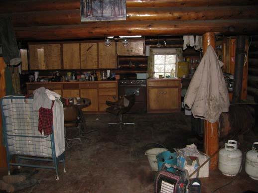
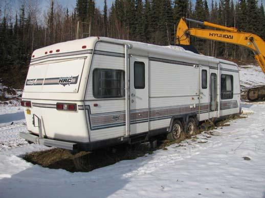
4 Cabin and outbuilding, approximately 20 x30 Interior of cabin Camper trailer


5 Tool camper trailer Service truck Fuel truck


6 6-inch Detroit pump Detroit gen set Shaker plant


7 Cat 988 Loader HD21 Dozer Road from bench down to Ingle Creek


8 Looking downstream from the top of Leo 2 Sluicing in August 2013 View looking south from bench
City of Six Project. Gold Mining Property in Downieville, CA. 60 Acres of Claims. Estimated Resource of over 8,800 ounces of Gold
 City of Six Project Gold Mining Property in Downieville, CA 60 Acres of Claims Estimated Resource of over 8,800 ounces of Gold Adjoining the famous Ruby Mine Property Located on a Rich Tertiary Channel
Compiling historic YCGC data for lower Hunker Creek and reconstructing gold distribution. Sydney van Loon Yukon Geological Survey
 Compiling historic YCGC data for lower Hunker Creek and reconstructing gold distribution Sydney van Loon Yukon Consolidated Gold Corp. inventoried creeks for over four decades; operated up to 12 dredges
BRY PLACER GROUP. Assessment Report Gravel,silt sampling and panning on. Claims: , , Located on map sheet 093A 062
 BRY PLACER GROUP Assessment Report 2012 Gravel,silt sampling and panning on Claims: 523068, 522278, 589718 Located on map sheet 093A 062 5~2 57'3/A/ / 31 Hi' 9 " )Aj Cariboo D/viS''on Owner-operator Egil
Amador Canyon Silver Mining Property Lander County, NV
 Amador Canyon Silver Mining Property Lander County, NV Over $1 million worth of exploration and evaluation work performed Favorable drill results including a return of 286 g/ton silver over 12.2 meters
GEOLOGY Warren Mining District Idaho County, Idaho March SlI4HARY
 r?..:. F-_.,'.': t.,.. I ~ j. ii lucky BEN motp GEOLOGY Warren Mining District Idaho County, Idaho March 1984 SlI4HARY.., The Lucky Ben Croup of claims cover a gold prospect located in the Wdrren Mining
Assessment Report #
 Table Of Contents Event Sheet #5576884 Exploration Program for 2015 Summery Introduction Location and Access Climate Local Resources and infrastructure Physiography Property Bedrock Geology History of
Elephant Mountain, Alaska Intrusive Related Gold Project July Option to Earn 100%
 Elephant Mountain, Alaska Intrusive Related Gold Project July 2018 Option to Earn 100% CORPORATE Corporate DISCLOSURE Disclosure The information contained herein, while obtained from sources which we believe
The Álamo Project Ensenada, Baja California North. April 2016 Eng. Juan Luis Frias Trevizo
 The Álamo Project Ensenada, Baja California North April 2016 Eng. Juan Luis Frias Trevizo SUMMARY The visit from the 28th to the 30th of March, 2016 has the following objectives Review the area to identify
SL GEOLOGY AND MINING. Coal bearing strata in the project area are referable primarily to the Allegheny Group of
 SL-145-1 GEOLOGY AND MINING Coal bearing strata in the project area are referable primarily to the Allegheny Group of Pennsylvania age. These rocks occur as dissected remnants overlying the ridge-forming
PROSPECTING REPORT. Broken Hill Property. EVENT # TENURE # Tenure Name: Broken Hill. New Westminster Mining Division Map 092H
 2009-2010 PROSPECTING REPORT Broken Hill Property EVENT # 4514071 TENURE # 600988 Tenure Name: Broken Hill New Westminster Mining Division Map 092H Central Coordinate Reference 121 24 26.2 W Longitude
PERCY CONTRACTING SERVICES LTD.
 GEOLOGICAL REPORT ON TEN PLACER LEASES (3139, 3140, 3141, 3142, 3143, 3144, 3145, 3146, 3147, 3148) MOREHEAD CREEK CARIB00 MINING DIVISION, B.C. 938/12W (52 38 N, 121 47 W) For PERCY CONTRACTING SERVICES
Introduction. Local Geology. Moose River. R. F. Mills and J. D. Chipman
 Report of Activities 2005 115 Investigation of Tills as Placer Ore Sources at Lake Catcha (NTS 11D/11) and Moose River (NTS 11D/15), Halifax County, and Kemptville (NTS 21A/04), Yarmouth County R. F. Mills
COLOR CLAIMS, INC. 637 S. 400 East, Cedar City, UT
 COLOR CLAIMS, INC. 637 S. 400 East, Cedar City, UT 84720 435-586-5072 435-590-5747 waynea1@yahoo.com Date: May 30, 2012 I, Craig Parkinson, Geologist, hereby state that the valuation report issued for
Reconnaissance. Of the. Denis mineral claims. Situated at Kilometer 844 of the Alaska Highway. Liard Mining Division. Northeastern British Columbia
 Reconnaissance Of the Denis mineral claims Situated at Kilometer 844 of the Alaska Highway Liard Mining Division Northeastern British Columbia N.T.S. 94M.075 Latitude 59 42 25 Longitude 127 13 12 Field
VICTORIA COPPER MINE
 THE VICTORIA COPPER MINE Elko County, Nevada USA Chuck Berg 801.947.8308 chuck.berg@coldwellutah.com CONTENTS SUMMARY... 1 LOCATION AND PROPERTY DESCRIPTION... 1 HISTORY... 3 PRODUCTION AND RESERVES...
LUCKY BEN MINE PROJECT SEPTEMBER 2018 UPDATE
 LUCKY BEN MINE PROJECT SEPTEMBER 2018 UPDATE During the first week of July 2018 work was completed by our Geologist, Richard Morris, and support personnel to stake the Lucky Ben vein structure at surface
Yukon Presentation. January 2015
 Yukon Presentation January 2015 Disclaimer This presentation contains forward looking statements. All statements, other than statements of historical fact, included herein, including without limitation,
Erosion Information Paper Eagle City and Eagle Village, Alaska Current as of January 21, 2008
 U.S. Army Corps of Engineers ALASKA BASELINE EROSION ASSESSMENT Erosion Information Paper Eagle City and Eagle Village, Alaska Current as of January 21, 2008 Community Information The City of Eagle, population
GPEX Mineral Property Portfolio. Coquihalla Gold Belt. ~ Ladner Suite ~
 GPEX Mineral Property Portfolio Coquihalla Gold Belt ~ Ladner Suite ~ GPEX s Ladner Suite consists of four properties, the Silver Salem, the Emancipation East, the Ladner Junction and West Hozameen claims.
NordWand Enterprize Mineral Exploration of Remote Regions P.O. Box Fairbanks, Alaska (vox & fax)
") Mineral Exploration of Remote Regions -2811 907-474-0943 (vox & fax) jokeener@acsalaska.net 1 October 2006 Richard Walters, President Little Squaw Gold Mining Company 3412 S. Lincoln Drive Spokane, WA
Mineral Exploration of Remote Regions -2811 907-474-0943 (vox & fax) jokeener@acsalaska.net 1 October 2006 Richard Walters, President Little Squaw Gold Mining Company 3412 S. Lincoln Drive Spokane, WA
entire 1.5 meter drift width
 GOLD HILL SUMMARY In 1864 gold fever struck in the south Kootenays east of Cranbrook, British Columbia as placer gold was discovered in the Wild Horse River. What followed was everything one can imagine
During August 18 to 21, 1962, James A, Fdilliams, Director. Mining Engineer, made a trip to the Chandalar District, where the Little
 REPORT ON EXPLORATION IN THE CHANDALAR DISTRICT, 1962 During August 18 to 21, 1962, James A, Fdilliams, Director of the Division of Mines Minerals, and Robert H. Saunders, State Mining Engineer, made a
EMORY PLACER CLAIM Yale Region New Westminster Mining Division
 EMORY PLACER CLAIM Yale Region New Westminster Mining Division EVENT # 4646011 TENURE # 608187 Tenure Name: Emory NTS Map 92H/11 Approximate Centre of Tenure 121 25 12 W Longitude 49 30 44 N Latitude Report
PROSPECTING REPORT. Karen Creek. EVENT # TENURE # Tenure Name: Karen Creek. New Westminster Mining Division Map 092H
 2008-2009 PROSPECTING REPORT Karen Creek EVENT # 4269354 TENURE # 578618 Tenure Name: Karen Creek New Westminster Mining Division Map 092H Central Coordinate Reference 121 17 30.7 W Longitude 49 26 21.9
Calculations for Road Maintenance
 objectives Calculations for Road Maintenance Provide a review of the mathematics commonly used in roadway maintenance to calculate areas, volumes, rates, and costs. Provide examples of common roadway maintenance
ENGINEER S CERTIFICATION OF FAULT AREA DEMONSTRATION (40 CFR )
") PLATTE RIVER POWER AUTHORITY RAWHIDE ENERGY STATION BOTTOM ASH TRANSFER (BAT) IMPOUNDMENTS LARIMER COUNTY, CO ENGINEER S CERTIFICATION OF FAULT AREA DEMONSTRATION (40 CFR 257.62) FOR COAL COMBUSTION RESIDUALS
PLATTE RIVER POWER AUTHORITY RAWHIDE ENERGY STATION BOTTOM ASH TRANSFER (BAT) IMPOUNDMENTS LARIMER COUNTY, CO ENGINEER S CERTIFICATION OF FAULT AREA DEMONSTRATION (40 CFR 257.62) FOR COAL COMBUSTION RESIDUALS
For personal use only
 ASX ANNOUNCEMENT / MEDIA RELEASE 16 th August, 2013 ASX:ABU Trial Mining Continues and Commissioning of the Old Pirate Processing Plant is Underway ABM Resources NL ( ABM or The Company ) presents an update
Gold Mineralization Potential in a Wabigoon Subprovince Granite-Greenstone Terrane, International Falls Area, Minnesota
 Gold Mineralization Potential in a Wabigoon Subprovince Granite-Greenstone Terrane, International Falls Area, Minnesota Manitoba Ontario Mn The State of Minnesota is located in the north-central portion
Wyoming State Operations Center
 Wyoming State Operations Center Updated Situation Report, Bordeaux Tornado site 14: 36 hrs 8 June 2012 Wyoming Office of Homeland Security (WOHS) arrived at the incident command post at the corner of Olson
The Gold Hill s Big Chief Showing. Cross Section Line A-A' (Pighin 2014)
") GOLD HILL SUMMARY In 1864 gold fever struck in the south Kootenays east of Cranbrook, British Columbia as placer gold was discovered in the Wild Horse River. What followed was everything one can imagine
GOLD HILL SUMMARY In 1864 gold fever struck in the south Kootenays east of Cranbrook, British Columbia as placer gold was discovered in the Wild Horse River. What followed was everything one can imagine
APPENDIX A M&T/Llano Seco Long-Term Water Reliability Study These photos are examples of rock spurs in use throughout the United States
 APPENDIX A M&T/Llano Seco Long-Term Water Reliability Study These photos are examples of rock spurs in use throughout the United States Glenn Colusa Irrigation District completed a Sacramento River project
FIELD TRIP GUIDE IDAHO MUSEUM OF MINING EXCURSION TO NORTHEAST OREGON, July 23, Mark L. Ferns, Eastern Oregon University
 FIELD TRIP GUIDE IDAHO MUSEUM OF MINING EXCURSION TO NORTHEAST OREGON, July 23, 2016 Mark L. Ferns, Eastern Oregon University Today s focus is on the mining history of northeast Oregon. The field trip
The Cobalt Rainbow. Airborne geophysical maps show that a north trending aeromagnetic high suggests further undiscovered mineralisation.
 The Cobalt Rainbow The property is located on Greenstone Creek, approximately 4.8 kilometres south west of the creek mouth. The property is located about 24 km due west of Campbell River, in the east-central
Cam and Motor Gold Mine
 Cam and Motor Gold Mine 03-04 August 2017 SAIMM CONFERENCE Cresta Lodge SEQUENCE OF PRESENTATION 1. Background. 2. Regional Geology and Historical Production 3. Geology and Orebody Modelling 4. Mine design
Field Observations and One-Dimensional Flow Modeling of Summit Creek in Mack Park, Smithfield, Utah
 Intermountain Center for River Rehabilitation and Restoration, Utah State University 31 July 2018 Field Observations and One-Dimensional Flow Modeling of Summit Creek in Mack Park, Smithfield, Utah I.
A NATURAL 1 DIVISION OF GEOLOGICAL & K%S LIBRARY AMATEUR COLD PROSPECTING PROPERTY OF. i?esources GEOPHYSICAL SURVEYS INFORMATION CIRCULAR
 DGGS puhiic:~tions are available $11: 3601 C St (10th fl.) Pouch 7.003 Xnchori~et*, 09510 P.O. Box 7-13s State Offtce Bldf. Ketch~kan. 99901 AMATEUR COLD PROSPECTING Revised March 30, i984 791 L'n~verst~y
3.12 Geology and Topography Affected Environment
 3 Affected Environment and Environmental Consequences 3.12 Geology and Topography 3.12.1 Affected Environment 3.12.1.1 Earthquakes Sterling Highway MP 45 60 Project Draft SEIS The Kenai Peninsula is predisposed
Advanced Geologic Exploration, Inc.
 Advanced Geologic Exploration, Inc. Scientists of the Earth PO Box 1956, Chester, CA 96020 Voice: (530) 258-4228 Fax (530) 258-4339 www.advancedgeologic.com January 23, 2009 Job No. G-081201 Terri Barber,
Prospecting Report 'S Office i DB Property, B.C. -J Negro Creek Nelson Mining District NTS 82F.050. Operator: Kootenay Gold Inc.
 . '.' I"' i9 12 Prospecting Report 'S Office i DB Property, B.C. -J Negro Creek Nelson Mining District NTS 82F.050 Operator: Kootenay Gold Inc. Owner: Darlene Lavoie Work Performed Summer of 2007 Report
REDWOOD VALLEY SUBAREA
 Independent Science Review Panel Conceptual Model of Watershed Hydrology, Surface Water and Groundwater Interactions and Stream Ecology for the Russian River Watershed Appendices A-1 APPENDIX A A-2 REDWOOD
CALUMET PLACER EXPLORATION RESULTS
 CALUMET PLACER - 1994 EXPLORATION RESULTS By: Hart W. Baitis Quartz Creek Mining December 3, 1994 INTRODUCTION The purpose of this report is to convey the results of an exploration program on the patented
Strategy. Focus on the western United States, mostly Nevada and California. Concentrate on projects with high grade and size potential
 Exploring for Gold and Silver in the US Jan. 2005 Strategy Focus on the western United States, mostly Nevada and California Concentrate on projects with high grade and size potential Become a gold producer
1 mna - J Assessment Report
 1 mna - J Assessment Report on GEOPHYSICAL AND PHYSICAL WORK on the CACHE Placer Claim Record No. PC 84 Fort Steele Mining Division NTS Map 82F 8/E North Latitude 49 Degrees 24 Minutes 12 Seconds West
Date Submitted: June General Nature of Report: Examination of Placer Samples
 General Nature of Report: Examination of Placer Samples Claim: Gold Channel, Record Number 3775!8 1 (Gold Channel Placer Property) Mining Division: Cariboo NTS 093 G 09 W and E Latitude 520 23 N' Longitude1210
PROSPECTING REPORT. re. Minera.1 C laims
 PROSPECTING REPORT re. Minera.1 C laims P R 1 Record #3052 (6) P R 2 Record #3053 (6) p R 3 Record #3054 (6) at Ilong.129, Latt. 58 20' in the Two Mile Creek area of Turnagain River drainage system in
1 FILMED 1. FILE NO:!..rsrru -* -. GRAND TWO CLAIM
 FILE NO:!..rsrru -* -. GRAND TWO CLAIM REPORT ON 1993 ASSESSMENT WORK GRAND TWO CLAIM REC. NO. 301849 NELSON MINING DIVISION NTS MAP SHEET 82F6/W 49 25'51" NORTH 117 18'08" WEST 1 FILMED 1 AUTHOR: R. Jordan,
EXPLORATION and DEVELOPMENT REPORT. Conrad Creek. PLACER and MINERAL CLAIMS SOUTHEAST BRITISH COLUMBIA
 EXPLORATION and DEVELOPMENT REPORT on Conrad Creek PLACER and MINERAL CLAIMS in SOUTHEAST BRITISH COLUMBIA Ed Friesen, BSc.E.E., P. Eng 8 Lake Placid Rise SE Calgary, Alberta T2J 5B5 April 2009 1 P age
12 tons of high-grade ore was mined from the No. 1 vein with an average grade of 13 g/t gold, 3,250 g/t silver and 23.3% lead.
 DUNWELL MINE GROUP The Dunwell Mine Group (Dunwell, Dunwell East, Bear River/MM and Silvershot properties), which includes the historic, past-producing Dunwell mine, is located 8 km northeast of Stewart
Nortec Minerals announces Option to acquire 100% interest in the Cottonwood Vanadium-Uranium Project, Utah
 Nortec Minerals announces Option to acquire 100% interest in the Cottonwood Vanadium-Uranium Project, Utah Vancouver, BC / The Newswire / March 8, 2019 (the Company or Nortec ) (TSXV: NVT): Nortec announces
for the Greenwood Mining Division, B.C. NTS 82E/7W 29' W, Longitude 118' 53' N Prepared by D. Dylan Watt, B.Sc.
 for the FltE NO: u VOLT 1, VOLT 2, VOLT 3, & VOLT 4 CLAIMS Greenwood Mining Division, B.C. NTS 82E/7W Latitude 49' 29' W, Longitude 118' 53' N Prepared by D. Dylan Watt, B.Sc. #309-1996 Trutch Street Vancouver,
BOOTY CLAIM TECHNICAL REPORT FOR EXPLORATION AND DEVELOPMENT. Tenure Number: Claim Name: BOOTY
 BOOTY CLAIM TECHNICAL REPORT FOR EXPLORATION AND DEVELOPMENT Tenure Number: 97064 Claim Name: BOOTY.. Mining Division: Carib, Map HB Spectacle Lakes NTS or BCGS Location: Lat 5 deg. 02 min., Long 121 deg.
Assessment Report on the Consolation Placer Property 45 Km Northeast of Atlin, BC
 Assessment Report on the Consolation Placer Property 45 Km Northeast of Atlin, BC NTS Location using NAD 83 Base on 1:20,000 Scale TRIM Maps 104 N 084 Centered on 133 degrees 19 W, 59 degrees 48 N And
#NCUMC4GUQWTEG&CVC(KNG/E%CTVJ[ SWCFTCPING#NCUMC
 #NCUMC4GUQWTEG&CVC(KNG/E%CTVJ[ SWCFTCPING#NCUMC $[ 6TCXKU. *WFUQP 1RGP(KNG 4GRQTV L 6JKU TGRQTV KU RTGNKOKPCT[ CPF JCU PQV DGGP TGXKGYGF HQT EQPHQTOKV[ YKVJ 75 )GQNQIKECN 5WTXG[ GFKVQTKCN UVCPFCTFU QT
PROSPECTING REPORT. Deneau Creek. EVENT # TENURE # Tenure Name: Deneau Creek. New Westminster Mining Division Map 092H
 2010-2011 PROSPECTING REPORT Deneau Creek EVENT # 4844921 TENURE # 578616 Tenure Name: Deneau Creek New Westminster Mining Division Map 092H Central Coordinate Reference 121 18 04.5 W Longitude 49 26 13.9
GEOLOGICAL BRANCH ASSESSMENT RERnRT. Assessment Report on Physical Work. CAYOOSH CONDOR Group of Placer Claims Lillooet Mining Division
 Assessment Report on Physical Work CAYOOSH CONDOR Group of Placer Claims Lillooet Mining Division PC 105 CAYOOSH CONDOR I1 PC 106 CAYOOSH CONDOR John P. La Rue June loth, 1991 Lillooet, B.C. GEOLOGICAL
The Owl Creek Pit Part 1: Relocating Mine Rock from Surface Stockpiles to the Pit to Mitigate Acid Drainage
 The Owl Creek Pit Part 1: Relocating Mine Rock from Surface Stockpiles to the Pit to Mitigate Acid Drainage Jeff Martin 1, Thomas Sulatycky 2, Brian Fraser 1, Rina Parker 1, Bruce Rodgers 1 and Ron Nicholson
STRUCTURAL STABILITY ASSESSMENT
 STRUCTURAL STABILITY ASSESSMENT CFR 257.73(d) Bottom Ash Pond Complex Cardinal Plant Brilliant, Ohio October, 2016 Prepared for: Cardinal Operating Company Cardinal Plant Brilliant, Ohio Prepared by: Geotechnical
A PRELIMINARY REPORT ON THE ZYMOST2 CLAIM GROtP, TERRACE, B.C.
 NATIVE EXPLORATIONS LTD. A PRELIMINARY REPORT ON THE ZYMOST2 CLAIM GROtP, TERRACE, B.C. INTRODUCTION': The Zymoetz claim group is, at present, held under option by Native Explorations Ltd.. On the 19th
Squaw Creek. General Information
 General Information is a tributary to the Salmon River. It enters the north side of the river about 0 miles downstream of North Fork, Idaho. The study reach is about a 30 ft length of stream about 2 miles
REPORT OF PHYSICAL EXPLORATION AND DEVELOPMENT Section 15 - Mineral Tenure Act Regulation
 1. EVENT NUMBER(S) 1234567 4. RECORDED HOLDER Doe 123 Main Street REPORT OF PHYSICAL EXPLORATION AND DEVELOPMENT Section 15 - Mineral Tenure Act Regulation Mineral Titles and Policy Branch Ministry of
GOLDCLIFF TULAMEEN PORPHYRY COPPER PROJECT COPPER MOUNTAIN CAMP, BRITISH COLUMBIA THE TROJAN-CONDOR COPPER TARGET HIGHLIGHTS
 Suite 350-885 Dunsmuir Street PF 250 764 8879 TF 866 769 4802 Vancouver, BC, Canada FX604 261 8994 info@goldcliff.com V6C 1N5 GCN.TSXV www.goldcliff.com GOLDCLIFF TULAMEEN PORPHYRY COPPER PROJECT COPPER
BUREAU OF MINERAL RESOURCES GEOLOGY AND GEOPHYSICS.
 Copy for Chief Geophysioira COMMONWEALTH OF AUSTRALIA. DEPARTMENT OF NATIONAL DEVELOPMENT. BUREAU OF MINERAL RESOURCES GEOLOGY AND GEOPHYSICS. RECORDS. 196 2/25 REPORT ON KUMBRUF GOLD PROSPECT MADANGDISTRICT,
TERRITORY OF ALASKA DEPARTMENT OF MINES JUNEAU. ALASKA. Report of!,fining Investigations on seward Peninsula BY
 TERRITORY OF ALASKA DEPARTMENT OF MINES JUNEAU. ALASKA Report of!,fining Investigations on seward Peninsula BY J. C. Roeh Associate Mining Engineer July 15 to August 6, 1946. ] 9 L,! d P. Only half of
Montgomery Bedrock Geology 21d-Gowganda Formation: conglomerate, sandstone, siltstone, argillite
 Work Report 2014 Trenching Montgomery Township G-3303 Claim #4259384,4245818 Sault Ste. Marie Mining Division Michael & Yvon Gagne Montgomery Copper Property 1 P a g e 2 P a g e Montgomery Bedrock Geology
BGND 2-7 CLAIMS, KELOWNA, B.C.
 GEOLOGICAL EVALUATION of BGND 2-7 CLAIMS, KELOWNA, B.C. 5"'33"N; 9"33'3"W:NTS 82L/4E BEAR CREEK: 4Km NNW of Kelowna Vernon Mining Div., British Columbia by N. C., P.Geol., P. Eng. Consulting Geologist,
O ITHIS )WE OF WORK IN I EXTENT OF WORK I I PROJECT COSTS I ON WHICH CLAIMS (IN METRIC UNITS) APPORTIONED (id. support) GEOLOGICAL (scale, area)
WE OF WORK IN I EXTENT OF WORK I I PROJECT COSTS I ON WHICH CLAIMS (IN METRIC UNITS) APPORTIONED (id. support) GEOLOGICAL (scale, area)") Geological Survey Branch TITLE OF REPORT [type of SUNOY(S)] TOTAL COST 1 MINERAL INVENTORY M OWNER@) MAILING ADDRESS -.,-- a 5 -a OPERATOR(S) [who paid ffo the wnk) 2) MAILING ADDRESS 76e2 HWY 97/gm LP
Geological Survey Branch TITLE OF REPORT [type of SUNOY(S)] TOTAL COST 1 MINERAL INVENTORY M OWNER@) MAILING ADDRESS -.,-- a 5 -a OPERATOR(S) [who paid ffo the wnk) 2) MAILING ADDRESS 76e2 HWY 97/gm LP
NOA ASSESSMENT HARRIS QUARRY MENDOCINO COUNTY, CALIFORNIA TABLE OF CONTENTS
 NOA ASSESSMENT HARRIS QUARRY MENDOCINO COUNTY, CALIFORNIA TABLE OF CONTENTS Introduction... 1 Scope of Services... 1 Project Location and Description... 1 Geologic Setting... 1 Regional Geology... 1 Site
PROSPECTING REPORT. Medallion Property. EVENT # TENURE # Tenure Name: GPEX CLVIII Medallion
 2006-2007 PROSPECTING REPORT Medallion Property EVENT # 4167980 TENURE # 540362 Tenure Name: GPEX CLVIII Medallion Watson Bar Region Clinton Mining Division Map 092O Central Coordinate Reference Long.
American Creek Resources is a precious metals exploration company with an impressive portfolio of high-potential gold
 American Creek Resources is a precious metals exploration company with an impressive portfolio of high-potential gold and silver projects in British Columbia. These include properties in B.C.'s prolific
PROSPECTING REPORT TENURES # / / CLAIM NAMES OLD SETTLER; OLD SETTLER1; OLD SETTLER2
 2011 PROSPECTING REPORT EVENT - 5160426 TENURES # 688183 / 691903 / 691905 CLAIM NAMES OLD SETTLER; OLD SETTLER1; OLD SETTLER2 COAST CRYSTALINE BELT REGION NEW WESTMINSTER MINING DISTRICT MAP - 092H GPS
SEASONAL WATER STORAGE AND REPLENISHMENT OF A FRACTURED GRANITE AQUIFER USING ASR WELLS
 SEASONAL WATER STORAGE AND REPLENISHMENT OF A FRACTURED GRANITE AQUIFER USING ASR WELLS Mario R. Lluria; Phillip M. Paski; Gary G. Small HydroSystems, Incorporated Phoenix, Arizona USA Presentation Contents
REPORT FOR ASSESSMENT WORKS ON CLAIMS SM SOVEREIGN GROUP 1 SM SOVEREIGN GROUP 2-80 UNITS CARIB00 MINING DIVISION. / f 93 B 16 E AND 93 A 13 W
 REPORT FOR ASSESSMENT WORKS ON CLAIMS SM SOVEREIGN GROUP 1-99 UNITS SM SOVEREIGN GROUP 2-8 UNITS N.T.S. CARIB MINING DIVISION / f 93 B 16 E AND 93 A 13 W LATITUDE &fo ( t O C 8. 5 ' LONGITUDE 2"(' Claims
Technical Report. Geochemical Sampling of Raymond Creek on Vancouver Island. Victoria Mining District 092C 15. UTM Co-ordinates N E
 Technical Report Geochemical Sampling of Raymond Creek on Vancouver Island Victoria Mining District 092C 15 UTM Co-ordinates 5414044N 389836E Owner of Claims is Dean Arbic(133434) Report Written by Dean
NEW MEXICO SCHOOL OF MINES. Richard H. Reece, President STATE BUREAU OF MINES AND MINERAL RESOURCES. E. C. Anderson, Director. Circular No.
 NEW MEXICO SCHOOL OF MINES Richard H. Reece, President STATE BUREAU OF MINES AND MINERAL RESOURCES E. C. Anderson, Director Circular No. 11 RECONNAISSANCE SURVEY OF THE HEADSTONE MINING DISTRICT RIO ARRIBA
THE ANTELOPE URANIUM PROJECT A Comparison of ISR and Heap Leach Extraction
 THE ANTELOPE URANIUM PROJECT A Comparison of ISR and Heap Leach Extraction Douglas Beahm, PE, PG, Principal Engineer BRS Inc., Riverton, WY Introduction The Energy Metals Corporation (EMC) holds numerous
DEVELOPMENT REPORT. Lone I Mineral Claim Group. Wild Horse River Area Cranbrook, B.C.
 DEVELOPMENT REPORT Lone I Mineral Claim Group Wild Horse River Area Cranbrook, B.C. Fort Steele Mining District NTS 82G/12E 49 38 35 Latitude 115 38 00 Longitude LONE PEAK PLACER LTD. 514-13th Avenue South
WHAT IS A ROCK? Granite. Muscovite. Orthoclase. Quartz. Feldspar. Biotite
 Mining, Jobs October 2014 WHAT IS A ROCK? A ROCK IS DEFINED AS AN COMBINATION OF ONE OR MORE MINERALS. Granite Orthoclase Muscovite Feldspar Quartz Biotite What Makes One Rock Better than Another Rock?
PROSPECTORS ASSISTANCE PROGRAM MINISTRY OF ENERGY AND MINES
 BRITISH COLUMBIA PROSPECTORS ASSISTANCE PROGRAM MINISTRY OF ENERGY AND MINES GEOLOGICAL SURVEY BRANCH PROGRAM YEAR: 1999/2000 REPORT #: PAP 99-l 6 NAME: KIM ANSCHETZ PROSPECTORS TlEPORT on the 99 LOUIS
GEOLOGIC ASSESSMENT / QUARRY PLAN REVIEW BLACK GOLD GRANITE QUARRY DEVELOPMENT
 GEOLOGIC ASSESSMENT / QUARRY PLAN REVIEW BLACK GOLD GRANITE QUARRY DEVELOPMENT GARIBALDI RESOURCES CORP. BLACK GOLD GRANITE CLAIMS GREENWOOD MINING DIVISION GRAND FORKS, B.C., CANADA NTS 82 E/7 E UTM (Zone
WEIR INTERNATIONAL, INC. Mining, Geology and Energy Consultants
 WEIR INTERNATIONAL, INC. Mining, Geology and Energy Consultants Introduction to Coal Mining History of Coal in the United States Coal was one of man s earliest sources of heat and light Coal was first
Gold Mountain Group Gold Mtn. A, B, C & D Mineral Claims Record Nos. 697, 698, 699 & 700. Island Mountain Cariboo Mining Division British Columbia
 GOLD POINT RESOURCES LTD. Geophysical Survey Gold Mountain Group Gold Mtn. A, B, C & D Mineral Claims Record Nos. 697, 698, 699 & 700 Island Mountain Cariboo Mining Division British Columbia Vancouver,
IGN A engineering & consulting ttd.
 IGN A engineering & consulting ttd. GEOLOGICAL REPORT ON THE PLACER MINING LEASES 82707 AND #1219 NINE MILE LAKE, NORTH OF WELLS CAR1600 N.T.S. M.D. 93H/4E For: Cancal Mines Ltd. By: I. Borovic, P. Eng.
for the Greenwood Mining Division, B.C. NTS 82E/7W Latitude 49' 27' W, Longitude 118' 5 Prepared by a= D. Dylan Watt, B.Sc.
 t. b LOGnO: 37~ -08 m. ACTIO#: for the AMP AMP 2 AMP 3 t AMP 4 CLAIMS Greenwood Mining Division, B.C. NTS 82E/7W Latitude 49' 27' W, Longitude 8' 5 %E c,w zc *& a w Prepared by a= -4c. D. Dylan Watt, B.Sc.
Geochemical Assessment Report. on the. Situated Nineteen Kilometres rth-northeast of Hope, B. C. in the. New Westminster Mining Division
 7 I Geochemical Assessment Report r on the r- I 1 Norm 1 to Norm 4 Mineral Claims c - I - 7 Situated Nineteen Kilometres rth-northeast of Hope, B. C. in the New Westminster Mining Division itude 49*32'N.,
ramr HHKEJ.nos "YEHT its ioiosyr
 OS6I ramr HHKEJ.nos "YEHT its ioiosyr 1 KOfiVSSITNSOOKH BiUKWaiH KOT8 1SLAHQS ITOIOOIOEf) HOIHSMI 0 ZJOOOKrdBa S3LlVJiS USGS - TEI Eept. 74-A Consisting of 5 pages Issued tog (See below) The distribution
PROSPECTING REPORT THE WALLACE CLAIM OMENICA MINING DIVISION. 54" x6" 3.d d. for. Reako Exlorat ions Ltd. Wallace Rev. C.G.
 PROSPECTING REPORT ON THE WALLACE CLAIM OMENICA MINING DIVISION 54"44 14 1x6" 3.d d by David A. Howard P.Eng. for Reako Exlorat ions Ltd. Claim Locat ion Wallace Rev. C.G. #1560 Dome Mountain Area 9 3
INTRUSIVE IGNEOUS MINERAL RESOURCES V
 INTRUSIVE IGNEOUS PROCESSES MINERAL RESOURCES V00290873 Intrusive features http://www.slackpacker.com/igneous.html Igneous bodies http://www.virginiawestern.edu/faculty/vwszaba/phisical/chapter%204.igneous%20rocks.htm
COAU PROPERTY LEMHI COUNTY, IDAHO
 COAU PROPERTY LEMHI COUNTY, IDAHO Utah Mineral Resources 447 N 300 W, Suite 3 Kaysville, UT 84037 (801) 544-3421 ojgatten@nae-xploration.com Prepared by: North American Mine Services, LLC. March 21, 2017
Geology 12 FINAL EXAM PREP. Possible Written Response Exam Questions
 Geology 12 FINAL EXAM PREP Possible Written Response Exam Questions Use this study guide to prepare for the written response portion of the final exam. Name FINAL EXAM - POSSIBLE WRITTEN RESPONSE QUESTIONS
ASSESSMENT REPORT GEOLOGICAL BRANCH. 50' 23 'North. GEOLOGICAL and GEOCHEMICAL SURVEYS ON THE. PUTNAM PROPERTY (Putnam Mineral Claim)
") GEOLOGICAL and GEOCHEMICAL SURVEYS ON THE PUTNAM PROPERTY (Putnam Mineral Claim) VERNON MINING DIVISION, B.C. GEOLOGICAL BRANCH ASSESSMENT REPORT NTS : Latitude: 82L17W 50' 23 'North LOCATION, ACCESS,
GEOLOGICAL and GEOCHEMICAL SURVEYS ON THE PUTNAM PROPERTY (Putnam Mineral Claim) VERNON MINING DIVISION, B.C. GEOLOGICAL BRANCH ASSESSMENT REPORT NTS : Latitude: 82L17W 50' 23 'North LOCATION, ACCESS,
Appendix G. Summary of Hydrogeologic Conditions and Historical Mining Northwest of the Centro Subarea in the Randsburg, Red Mountain, and Atolia Area
 Appendix G Summary of Hydrogeologic Conditions and Historical Mining Northwest of the Centro Subarea in the Randsburg, Red Mountain, and Atolia Area 1.1 Background This appendix provides a summary of hydrogeologic
Intrusive Igneous Processes
 Intrusive Igneous Processes Mineral Resources http://pubs.usgs.gov/of/2004/1007/volcanic.html Intrusive features Sill diagram http://www.tulane.edu/~sanelson/geol111/igneous.htm sill Columnar jointing
BUREAU OF MINES IN-THE TIBBS CREEK AREA, GOODPASTER RIVER, BIG DELTA QUADRANGLE, CENTRAL ALASKA. wl : by Bruce I. Thomas
 > RECONNAISSANCE OF THE GOLD-BEARING QUARTZ VEINS IN-THE TIBBS CREEK AREA, GOODPASTER RIVER, BIG DELTA QUADRANGLE, CENTRAL ALASKA wl : by Bruce I. Thomas ::'0% S 0 open fil X ;:0report w, UNITED STATES
PROSPECTING REPORT TENURES # / / CLAIM NAMES OLD SETTLER; OLD SETTLER1; OLD SETTLER2
 2010 PROSPECTING REPORT EVENT # 4820658 TENURES # 688183 / 691903 / 691905 CLAIM NAMES OLD SETTLER; OLD SETTLER1; OLD SETTLER2 COAST CRYSTALINE BELT REGION NEW WESTMINSTER MINING DISTRICT MAP - 092H GPS
Summary of Rover Metals Geologic Mapping Program at the Up Town Gold Project, Northwest Territories
 October 13, 2017 Summary of Rover Metals Geologic Mapping Program at the Up Town Gold Project, Northwest Territories Vancouver, British Columbia, Canada - Rover Metals Corp., Rover, is pleased to provide
FILE NO. ASSESSMENT REPORT VLF-EM GEOPHY S I CS BUCK CLAIMS. Moyie River and Perry Creek Area FORT STEELE MINING DIVISION. NTS 82 F/8 E and 82 G/5 W
 FILE NO. ASSESSMENT REPORT on - VLF-EM GEOPHY S I CS BUCK CLAIMS Moyie River and Perry Creek Area FORT STEELE MINING DIVISION NTS 82 F/8 E and 82 G/5 W Latitude 49 27' N Longitude 116 03' W PETER KLEWCHUK
Table E1. Site details for reaches selected for PHABSIM surveys in 2007
 SURVEY DATA The relationships between available trout habitat and stream flow were investigated during the 2007, 2008 and 2009 field seasons in 21 locations using the PHABSIM (Physical Habitat Simulation)
Highland Lake Bathymetric Survey
 Highland Lake Bathymetric Survey Final Report, Prepared For: The Town of Highland Lake 612 Lakeshore Drive Oneonta, AL 35121 Prepared By: Tetra Tech 2110 Powers Ferry Road SE Suite 202 Atlanta, GA 30339
CASE STUDIES. Introduction
 Introduction The City of Winston-Salem faces the challenge of maintaining public infrastructure (e.g., water and sewer lines, storm drains, roads, culverts and bridges) while minimizing the potential impacts
Big Rivers Electric Corporation Disposal of Coal Combustion Residuals (CCR) from Electric Utilities Final Rule CCR Impoundment Liner Assessment Report
 from Electric Utilities Final Rule CCR Impoundment Liner Assessment Report") Big Rivers Electric Corporation Disposal of Coal Combustion Residuals (CCR) from Electric Utilities Final Rule CCR Impoundment Liner Assessment Report CCR Surface Impoundment Information Name: Operator:
Big Rivers Electric Corporation Disposal of Coal Combustion Residuals (CCR) from Electric Utilities Final Rule CCR Impoundment Liner Assessment Report CCR Surface Impoundment Information Name: Operator: