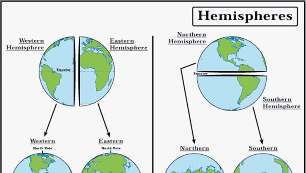
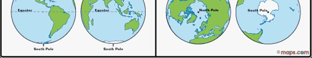
Map Elements & The 5 Oceans
|
|
|
- Grant Martin
- 6 years ago
- Views:
Transcription
1 Map Elements & The 5 Oceans

2 Latitude and Longitude Longitude lines run north and south. Latitude lines run east and west. The lines measure distances in degrees. Latitude Longitude


3 Where is 0 degrees? The equator is 0 degree latitude. It is an imaginary belt that runs halfway point between the North Pole and the South Pole. Equator The prime meridian is 0 degrees longitude. This imaginary line runs through the P R United Kingdom, I France, Spain, western Africa, E and Antarctica. M M E R I D I A N
4

5 The Tropics of Cancer & Capricorn


6 Compass A tool that helps the user know what direction one is headed. On a map, a compass or a compass rose helps the user locate these directions. Scale Shows direct connection between a unit of measurement on the map and the actual distance. For example, each inch on the map represents one mile on Earth. So, a map of a town would show a mile-long strip of fast food joints and auto dealers in one inch.
7 THE 5 OCEANS
8 THE 5 OCEANS Atlantic Pacific Indian Arctic Southern

9 Atlantic Ocean Physical Characteristics 2 nd largest ocean (1/5 of Earth s surface) Deepest point Puerto Rico Trench Spreads along Mid-Atlantic Ridge by 2-4 cm per year Relatively young 150 million years old
10 Atlantic Ocean Bonus Information Northern portion bordered by most industrialized countries (busiest shipping waterway) Some of the richest fishing grounds along continental shelves Sargasso Sea (in N. Atlantic) is a huge area of calm, still water, famous for the green brown seaweed that covers its surface

11 Atlantic Ocean Bonus Information Contains the Caribbean Sea, which holds a great deal of the world s coral reefs Iceland and Ascension Island are parts of the Mid-Atlantic Ridge that rise above the water

12 Northern Atlantic Ocean
 each year Contains more trenches, seamounts, volcanic islands, and hydrothermal vents than any other ocean")
13 Pacific Ocean Physical Characteristics Largest Ocean (2x the size of Atlantic) 1/3 of Earth s surface Deepest Point Mariana Trench Widening at a rate of cm at East Pacific Rise (underwater mountain range) each year Contains more trenches, seamounts, volcanic islands, and hydrothermal vents than any other ocean
14 Pacific Ocean Bonus Information Some areas are covered with small black lumps, called manganese nodules which are used for pains, batteries, and steel Contains large, narrow fracture zones along the East Pacific Rise Philippine Sea is fairly large and contains the Mariana s Trench (the deepest part of the ocean) Coral Sea contains the largest coral reef (Great Barrier Reef near Australia)


15 Pacific Ocean Bonus Information San Andreas Fault lies between the Pacific Plate and the N. American Plate Sand on some beaches is black, from formation of the island by volcanic activity

16 Pacific Ocean


17 Indian Ocean Physical Characteristics 3 rd largest ocean Deepest Point Java Trench Formed 140 million years ago when India, Africa, and Antarctica separated
18 Indian Ocean Physical Characteristics Upside-down Y-shaped mid-ocean ridge Mid-ocean ridges separate the ocean bed into several basins, some of which are the flattest places on Earth
 and the warmest sea (Persian Gulf) on Earth Home of massive volcanic")
19 Indian Ocean Bonus Information Unique current pattern monsoon winds change the currents twice a year Winter toward Africa Summer toward India Contains the saltiest sea (Red Sea) and the warmest sea (Persian Gulf) on Earth Home of massive volcanic eruptions

20 Indian Ocean
21 Arctic Ocean Physical Characteristics Smallest & Shallowest ocean Only ocean almost entirely surrounded by land (Europe, Asia, Greenland, & North America) Waters are covered by a thick sheet of ice for most of the year
22 Arctic Ocean Bonus Information North Pole lies in the middle of a raft of ice, not on top of solid land Unusually wide areas of continental shelf under the ice (accounts for shallow depth) Summer days are extremely long, winter days are very short

23 Arctic Ocean Bonus Information Littered with icebergs (Greenland itself lies under an enormous ice cap) Wildlife exists only around the edges The International Date Line crosses the Chukchi Sea from NW to SE. This is also wear many polar bears are found. Contains the Beaufort Sea which has significant resources of petroleum and natural gas under its shelf

24 Arctic Ocean
25 Southern Ocean Physical Characteristics 4 th Largest and surrounds only the continent of Antarctica Defined as waters South of 60 S latitude Has the coldest and windiest climate on earth Winter F with winds reaching 190 mph Summer near 32 F or just above

26 Southern Ocean Massive weight of ice (which covers all but 5% of the land) pushes most of the land below sea level, though some peaks do break the surface Previously unofficially known as the Antarctic Ocean. (Officially named Southern in 2000) Fringed with ice even at the height of summer East Wind Drift current flows counterclock-wise around the land, and the West Wind Drift flows clockwise which sweep waters extremely far
27 Southern Ocean Bonus Information Teems with plankton, which attracts many other types of wildlife Contains the Ross Sea - contain a number of rookeries of Adélie and Emperor penguins. And is one of the last stretches of seas on Earth that remains relatively unaffected by human activities. Because of this, it is remains almost totally free from pollution, overfishing and the introduction of invasive species.

28 Southern Ocean
Chapter 1 Section 2. Land, Water, and Climate
 Chapter 1 Section 2 Land, Water, and Climate Vocabulary 1. Landforms- natural features of the Earth s land surface 2. Elevation- height above sea level 3. Relief- changes in height 4. Core- most inner
Continents. and. Oceans
 Continents and Oceans Continents and Oceans Africa Africa Antarctica Antarctica Asia Asia Australia Australia Europe Europe North America North America South America South America World Map World Map Continents
Oceanography is the scientific study of oceans Oceans make up over 70% of the Earth s surface
 Oceanography Oceanography is the scientific study of oceans Oceans make up over 70% of the Earth s surface An ocean must be large and have features which set it apart from other oceans (currents, water
GEOGRAPHY. Map Skills. Mrs. Pere ~ 2013
 GEOGRAPHY Map Skills Mrs. Pere ~ 2013 WHAT IS A GLOBE? A globe is a model of the Earth. North Pole Equator South Pole WHAT IS A MAP? A map is a flat drawing of a place. THE IMPORTANT PARTS OF A MAP 1.
The surface of the ocean floor is as varied as the land. The five major oceans, from largest to smallest, are
 11.1 Ocean Basins The surface of the ocean floor is as varied as the land. The five major oceans, from largest to smallest, are w the Pacific w the Atlantic w the Indian w the Southern w the Arctic The
Major Domain of the Earth
 Major Domain of the Earth The surface of the earth is a complex zone in which three main components of the environment meet, overlap and interact. The solid portion of the earth on which we live is called
Pangaea to the Present Lesson #2
 Pangaea to the Present Lesson #2 The Earth is a dynamic or constantly changing planet. The thin, fragile plates slide very slowly on the mantle's upper layer. This sliding of the plates is caused by the
The Southern Ocean. Copyright 2010 LessonSnips
 The Southern Ocean Even though oceanographers currently define five oceans on earth, in reality there is but one ocean. The fact that the ocean is one single entity and the divisions of the ocean are man-made
A) B) C) D) 4. Which diagram below best represents the pattern of magnetic orientation in the seafloor on the west (left) side of the ocean ridge?
 B) C) D) 4. Which diagram below best represents the pattern of magnetic orientation in the seafloor on the west (left) side of the ocean ridge?") 1. Crustal formation, which may cause the widening of an ocean, is most likely occurring at the boundary between the A) African Plate and the Eurasian Plate B) Pacific Plate and the Philippine Plate C)
1. Crustal formation, which may cause the widening of an ocean, is most likely occurring at the boundary between the A) African Plate and the Eurasian Plate B) Pacific Plate and the Philippine Plate C)
Full file at
 Essentials of Oceanography, 10e (Trujillo/Keller) Chapter 2 Plate Tectonics and the Ocean Floor Match the term with the appropriate phrase. You may use each answer once, more than once or not at all. A)
ATOC 5051 INTRODUCTION TO PHYSICAL OCEANOGRAPHY. Lecture 2
 ATOC 5051 INTRODUCTION TO PHYSICAL OCEANOGRAPHY Lecture 2 Ocean basins and relation to climate Learning objectives: (1)What are the similarities and differences among different ocean basins? (2) How does
Cardinal and Intermediate Directions:
 Name Period Parent Signature Due Date: (TBA) Geography/Map Skills Study Guide Continents and Oceans of the World: Label the continents (7) and oceans (4) on the lines below the map. 1 11 3 5 4 8 2 9 10
Unit 4 - Water. Earth s Interior. Earth s Interior. Continental Drift. Continental Drift. Continental Drift. Crust. Mantle. Core.
 Unit 4 - Water How did the oceans form? What special adaptations do saltwater organisms have? Where does our water come from? How do humans affect the Earth s water? Crust Rigid outer shell of Earth Oceanic
Introduction to Oceanography. Chapter 2: Plate Tectonics Overview
 Introduction to Oceanography Chapter 2: Plate Tectonics Overview Much evidence supports plate tectonics theory. The plate tectonics model describes features and processes on Earth. Plate tectonic science
Understanding Projections
 GEOGRAPHY SKILLS 1 Understanding Projections The earth is a sphere and is best shown as a globe. For books and posters, though, the earth has to be represented as a flat object. To do this, mapmakers create
Pre-AP World Geography Summer Assignment
 Pre-AP World Geography 2018-2019 Summer Assignment This is the summer assignment for students who intend on being accepted and enrolled in Pre-AP World Geography. Successful performance on this assignment
Plate Tectonics GEOL 101 Lecture 22 How Are Mountains Built?
 Plate Tectonics GEOL 101 Lecture 22 How Are Mountains Built? The Grand Tetons, Wyoming First a Brief Review of Sea Floor Spreading Prop: Test 3 Invitations Break-Up of a Continent and Origin of an Ocean
Ocean Floor. Continental Margins. Divided into 3 major regions. Continental Margins. Ocean Basins. Mid-Ocean Ridges. Include:
 Ocean Floor Divided into 3 major regions Continental Margins Ocean Basins Mid-Ocean Ridges Continental Margins Include: Continental Shelves Continental Slopes Continental Rise 1 Continental Shelves Part
On Earth, the land is broken into large pieces. These pieces are separated by large bodies of water called oceans. We call some of these pieces of
 The 7 Continents On Earth, the land is broken into large pieces. These pieces are separated by large bodies of water called oceans. We call some of these pieces of land continents. A continent is an area
MARINE GEOLOGY & GEOGRAPHY
 MARINE GEOLOGY & GEOGRAPHY Bathymetry BATHYMETRY BATHYMETRY THE UNDERWATER EQUIVALENT TO TOPOGRAPHY THE STUDY OF WATER DEPTH A BATHYMETRIC MAP SHOWS FLOOR RELIEF OR TERRAIN AS CONTOUR LINES Bathymetry
Alfred Wegener gave us Continental Drift. Fifty years later...
 CHAPTER 2 Plate Tectonics and the Ocean Floor Plate Tectonics: summary in haiku form Alfred Wegener gave us Continental Drift. Fifty years later... Words Chapter Overview Much evidence supports plate tectonics
Almost of Earth is covered by water. On a map, the continents appear as huge islands surrounded by a vast global ocean.
 Earth s Oceans & Ocean Floor Date: Feelin Blue What are Earth s five main oceans? Almost of Earth is covered by water. On a map, the continents appear as huge islands surrounded by a vast global ocean.
D) 15 N, 160 W A) prevailing wind direction
 15 N, 160 W A) prevailing wind direction") Base your answers to questions 1 and 2 on the diagram below, which represents latitude and longitude lines on Earth. Points A through E represent locations on Earth. Arrows represent direction of rotation.
Base your answers to questions 1 and 2 on the diagram below, which represents latitude and longitude lines on Earth. Points A through E represent locations on Earth. Arrows represent direction of rotation.
The Sea Floor. Chapter 2
 The Sea Floor Chapter 2 Geography of the Ocean Basins World ocean is the predominant feature on the Earth in total area Northern Hemisphere = 61% of the total area is ocean. Southern Hemisphere = about
Essentials of Oceanography Eleventh Edition
 Chapter Chapter 1 2 Clickers Lecture Essentials of Oceanography Eleventh Edition Plate Tectonics and the Ocean Floor Alan P. Trujillo Harold V. Thurman Chapter Overview Much evidence supports plate tectonics
Directed Reading. Section: Ocean Currents. a(n). FACTORS THAT AFFECT SURFACE CURRENTS
. FACTORS THAT AFFECT SURFACE CURRENTS") Skills Worksheet Directed Reading Section: Ocean Currents 1 A horizontal movement of water in a well-defined pattern is called a(n) 2 What are two ways that oceanographers identify ocean currents? 3 What
Skills Worksheet Directed Reading Section: Ocean Currents 1 A horizontal movement of water in a well-defined pattern is called a(n) 2 What are two ways that oceanographers identify ocean currents? 3 What
Chapter 02 The Sea Floor
 Chapter 02 The Sea Floor Multiple Choice Questions 1. One of the following is not one of the world's major ocean basins: A. Atlantic Ocean B. Arctic Ocean C. Indian Ocean D. Antarctic Ocean E. Pacific
Earth Science Lesson 3 Dynamic Earth Processes (Grades 8-12 ) Instruction 3-3 Plate Boundaries
 Instruction 3-3 Plate Boundaries") As we told you in a recent Instruction, much of the Earth's lithosphere (its Crust and the top layer of its Outer Mantle) is made up of moving masses of rock called tectonic plates (tectonic means moving).
As we told you in a recent Instruction, much of the Earth's lithosphere (its Crust and the top layer of its Outer Mantle) is made up of moving masses of rock called tectonic plates (tectonic means moving).
Sample file. Teacher Guide ... Before You Teach. Our resource has been created for ease of use by both TEACHERS and STUDENTS alike.
 8 7 9 10 12 13 14 11 Introduction T his resource provides ready-to-use information and activities for remedial students in grades five to eight. Written to grade and using simplified language and vocabulary,
Looking at the world map, what do you notice about the shape of the continents? Jot down your ideas on your paper
 Looking at the world map, what do you notice about the shape of the continents? Jot down your ideas on your paper The thing is the world didn t always look like this! It used to look like this: How is
TAKE HOME EXAM 8R - Geology
 Name Period Date TAKE HOME EXAM 8R - Geology PART 1 - Multiple Choice 1. A volcanic cone made up of alternating layers of lava and rock particles is a cone. a. cinder b. lava c. shield d. composite 2.
Small area of the ocean that is partially surrounded by land. The Ocean Basins. Three Major Oceans. Three Major Oceans. What is a SEA?
 The Ocean Basins How Deep is the Ocean? 1 2 Three Major Oceans Three Major Oceans Pacific Atlantic the shallowest ocean (3.3km average depth) Indian second shallowest ocean (3.8km average depth) Pacific
Chapter 2 Plate Tectonics and the Ocean Floor
 Chapter 2 Plate Tectonics and the Ocean Floor Matching. Match the term or person with the appropriate phrase. You may use each answer once, more than once or not at all. 1. hydrothermal vents A. convergent
Do Now: Vocabulary: Objectives. Vocabulary: 1/5/2016. Wegener? (Can they move?) the idea that continents have moved over time?
 the idea that continents have moved over time?") Do Now: 1. Who was Alfred Wegener? 2. What was Pangaea? 3. Are continents fixed? (Can they move?) 4. What evidence supports the idea that continents have moved over time? Objectives What evidence suggests
Do Now: 1. Who was Alfred Wegener? 2. What was Pangaea? 3. Are continents fixed? (Can they move?) 4. What evidence supports the idea that continents have moved over time? Objectives What evidence suggests
MARINE GEOLOGY & GEOGRAPHY
 MARINE GEOLOGY MARINE GEOLOGY & GEOGRAPHY Marine Geology 4 LAYERS OF THE EARTH CRUST THICKNESS: VARIES BETWEEN OCEAN & CONTINENTS 5-40 KM STATE: SOLID ELEMENTS: SILICON, ALUMINUM, CALCIUM, SODIUM, POTASSIUM
Map shows 3 main features of ocean floor
 Map shows 3 main features of ocean floor 2017 Pearson Education, Inc. Chapter 3 Marine Provinces 2017 Pearson Education, Inc. 1 Chapter 3 Overview The study of bathymetry determines ocean depths and ocean
The Indian Ocean. Copyright 2010 LessonSnips
 The Indian Ocean One of the five major geographic divisions of the world s ocean, the Indian Ocean is located in the Eastern Hemisphere. The Indian Ocean is bounded by three continents: Africa to the west,
Map Skills Unit. Note taking unit
 Map Skills Unit Note taking unit Introduction To learn about the Earth, we are going to learn about two geographic tools you can use.globes and maps. Globe A globe is a round model of the planet Earth
USU 1360 TECTONICS / PROCESSES
 USU 1360 TECTONICS / PROCESSES Observe the world map and each enlargement Pacific Northwest Tibet South America Japan 03.00.a1 South Atlantic Arabian Peninsula Observe features near the Pacific Northwest
Continental Drift. & Plate Tectonics
 Continental Drift & Plate Tectonics Alfred Wegener, a German scientist, proposed the hypothesis of CONTINENTAL DRIFT, in 1912. Hypothesis stated: All Earth s continents were once a single landmass (Pangaea)
Chapter 2 Plate Tectonics and the Ocean Floor
 Chapter 2 Plate Tectonics and the Ocean Floor Chapter Overview Much evidence supports plate tectonics theory. The plate tectonics model describes features and processes on Earth. Plate tectonic science
Map Skills Lesson 1. Materials: maps, pencils, Lesson 1 Worksheet, strips of paper, grid paper
 Map Skills Lesson 1 Use cardinal directions, map grids, scales, and titles to locate places on a map. Interpret a map using information from its title, compass rose, scale, and legend. Vocabulary: map,
Crustal Boundaries. As they move across the asthenosphere and form plate boundaries they interact in various ways. Convergent Transform Divergent
 Name: Date: Period: Plate Tectonics The Physical Setting: Earth Science CLASS NOTES Tectonic plates are constantly moving and interacting As they move across the asthenosphere and form plate boundaries
Unit 1: Basics of Geography Test Review
 Name Date Period Unit 1: Basics of Geography Test Review Directions: Reading the following sections and complete the questions, charts, and diagrams. Types of Maps Maps that have a particular theme are
Introduction to Geography
 Introduction to Geography ropic of Cancer 3½ N Arctic Circle 90 N Prime Meridian 0 Arctic Ocean Mississippi R. Appalachian Mts. Europe Rocky Mountains N. America Atlantic Gulf of Ocean Mexico Caribbean
 Name Period Parent Signature Geography/Map Skills Study Guide *For extra practice with these skills, check out Mr. Kath s website: http://rkath.weebly.com/activities--links.html Continents and Oceans of
Evidence for Continental Drift and The Theory of Plate Tectonics
 Evidence for Continental Drift and The Theory of Plate Tectonics Did you know that the coal that is mined in Pennsylvania was actually formed from tropical plant life near the Equator? How did it travel
THE EARTH S RELIEF SOCIAL SCIENCES 1º ESO
 THE EARTH S RELIEF SOCIAL SCIENCES 1º ESO 1. THE STRUCTURE OF THE EARTH The Earth is divided into layers: The crust is the surface layer. It is a thin, solid layer made of rock. The Earth s crust has a
Map Skills: Continents and Oceans. Map Skills: Continents and Oceans
 Map Skills: Continents and Oceans Our Earth is made up of continents and oceans. A continent is an enormous mass of land. There are seven continents on our planet. The continents include North America,
WHAT IS THE EARTH MADE OF? LITHOSPHERE AND HYDROSPHERE
 UNIT 8 WHAT IS THE EARTH MADE OF? LITHOSPHERE AND HYDROSPHERE TABLE OF CONTENTS 1 THE STRUCTURE OF THE EARTH... 2 2 THE FORMATION OF THE RELIEF: INTERNAL AND EXTERNAL FORCES.... 2 2.1 Internal forces:
... Europe. Based on Bloom s Taxonomy. Environment Interactions Movement. Human & Location. Regions. Place
 ... Europe Location Place Human & Environment Interactions Movement Regions LEVEL 1 Knowledge Match Show or Label List Information Recall Details (5Ws + H) Find Information LEVEL 2 Comprehension Describe
I. Earth s Layers a. Crust: Earth s outside layer. Made of mostly rock. i. Continental: er; made of mostly granite, forms the continents and shallow
 I. Earth s Layers a. Crust: Earth s outside layer. Made of mostly rock. i. Continental: er; made of mostly granite, forms the continents and shallow sea beds, floats! ii. Oceanic: er; dense rock such as
Chapter Overview. Bathymetry. Measuring Bathymetry. Measuring Bathymetry
 CHAPTER 3 Marine Provinces Chapter Overview The study of bathymetry determines ocean depths and ocean floor topography. Echo sounding and satellites are efficient bathymetric tools. Most ocean floor features
3. The diagram below shows how scientists think some of Earth's continents were joined together in the geologic past.
 1. The map below shows the present-day locations of South America and Africa. Remains of Mesosaurus, an extinct freshwater reptile, have been found in similarly aged bedrock formed from lake sediments
Earth s Changing Continents
 2 What You Will Learn Earth s continents have moved around Earth s surface throughout Earth s history and have only recently arrived at their current locations. Rocks and fossils provide evidence of continental
Introduction to the Seafloor. Follow the steps below while taking notes in your science notebook.
 Procedure Follow the steps below while taking notes in your science notebook. 1. Name and locate all of the continents. 2. Identify linear (straight-line) and arcuate (curved-line) features on the continents.
Movement of the Earth s Crust: Formation of: Mountain s Plateau's and Dome s
 Movement of the Earth s Crust: Formation of: Mountain s Plateau's and Dome s References Information taken from several places including Prentice Hall Earth Science: @ http://www.eram.k12.ny.us/education/components/docmgr/default.php?sectiondetaili
Bathymetry Measures the vertical distance from the ocean surface to mountains, valleys, plains, and other sea floor features
 1 2 3 4 5 6 7 8 9 10 11 CHAPTER 3 Marine Provinces Chapter Overview The study of bathymetry determines ocean depths and ocean floor topography. Echo sounding and satellites are efficient bathymetric tools.
Practice Questions: Plate Tectonics
 Practice Questions: Plate Tectonics 1. Base your answer to the following question on The block diagram below shows the boundary between two tectonic plates. Which type of plate boundary is shown? A) divergent
Chapter Overview. Evidence for Continental Drift. Plate Tectonics. Evidence for Continental Drift. Evidence for Continental Drift 9/28/2010
 Chapter Overview CHAPTER 2 Plate Tectonics and the Ocean Floor Much evidence supports plate tectonics theory. Different plate boundaries have different features. Tectonic plates continue to move today.
In the space provided, write the letter of the definition that best matches the term or phrase.
 Skills Worksheet Directed Reading Section: The Changing Continents 1. What is the result of slow movements of tectonic plates? RESHAPING EARTH S CRUST In the space provided, write the letter of the definition
Map Skills Test. 1. What do we call a person who makes maps? a. mapographer b. cartographer c. geologist d. archaeologist
 Map Skills Test 1. What do we call a person who makes maps? a. mapographer b. cartographer c. geologist d. archaeologist 2. What is the name of the 0 latitude line? a. Equator b. Arctic Circle c. First
2 Georgia: Its Heritage and Its Promise
 TERMS region, erosion, fault, elevation, Fall Line, aquifer, marsh, climate, weather, precipitation, drought, tornado, hurricane, wetland, estuary, barrier island, swamp PLACES Appalachian Mountains, Appalachian
ARE YOU READY TO THINK? Look at the first slide THINK PAIR SHARE!
 ARE YOU READY TO THINK? Look at the first slide THINK PAIR SHARE! WHAT PROMINENT FEATURE CAN YOU IDENTIFY IN THIS PICTURE? What do you think the different colors represent? Who might find such a picture
Plate Tectonics CHAPTER 17
 Plate Tectonics CHAPTER 17 Layers of the Earth A. Crust- solid, 5-70 km thick Moho Two Types of Crust: Oceanic- ocean floor, more dense then because of more iron Continental-dry land (mostly silicates
Plate Tectonics. Earth has distinctive layers - Like an onion
 Plate Tectonics Earth has distinctive layers - Like an onion Earth s Interior Core: Metallic (Iron, Nickel) Inner (hot, solid, dense, Iron, Nickel) Outer (cooler, liquid, less dense) Crust (outermost layer):
12. The diagram below shows the collision of an oceanic plate and a continental plate.
 Review 1. Base your answer to the following question on the cross section below, which shows the boundary between two lithospheric plates. Point X is a location in the continental lithosphere. The depth
Unit 1: Geography and Social Studies Skills
 Unit 1: Geography and Social Studies Skills Standard(s) of Learning: WHI.1 The student will improve skills in historical research and geographical analysis by a) Identifying, analyzing, and interpreting
A Living Planet. The Earth Inside and Out
 A Living Planet The Earth Inside and Out Planet Earth Earth s Rotation, Revolution, and Tilt Most of Earth s energy comes from the Sun, which we call solar energy. Imagine that the Earth has an imaginary
Earth s Continents and Seafloors. GEOL100 Physical Geology Ray Rector - Instructor
 Earth s Continents and Seafloors GEOL100 Physical Geology Ray Rector - Instructor OCEAN BASINS and CONTINENTAL PLATFORMS Key Concepts I. Earth s rocky surface covered by of two types of crust Dense, thin,
1. Define habitat and describe how geologic processes influence habitats. Habitats 2. How much of the earth s surface is covered by sea water?
 1. Define habitat and describe how geologic processes influence habitats. Habitats are the natural environments in which organisms live. They are directly shaped by geological processes, which influence
Why VOCABULARY? clues
 It s GHSGT Time! Why VOCABULARY? Social Studies is all about MAKING CONNECTIONS Key Terms provide relational clues to guide you in answering test questions! The more WORDS you know, the smarter you are
Module 7: Plate Tectonics and Earth's Structure Topic 2 Content: Plates of the World Presentation Notes
 There are several large plates and several smaller plates that comprise the Earth s crust. How do these plates interact with the bordering plates? Review each of the world s plates and the landforms that
Plate Tectonics. Essentials of Geology, 11 th edition Chapter 15
 1 Plate Tectonics Essentials of Geology, 11 th edition Chapter 15 2 3 4 5 6 7 8 9 10 11 12 13 14 15 Plate Tectonics: summary in haiku form Alfred Wegener gave us Continental Drift. Fifty years later...
Unit 1: Geography. For additional information, refer to this website: 1 G e o g r a p h y
 Unit 1: Geography For additional information, refer to this website: http://mryoungtms.weebly.com/ 1 G e o g r a p h y Continents and Oceans SOL USI. 2a Essential Understanding: Continents are large land
Directed Reading. Section: The Water Planet. surface is called the a. Earth s ocean. b. Pacific Ocean. c. salt-water ocean. d. global ocean.
 Skills Worksheet Directed Reading Section: The Water Planet 1. The body of salt water covering nearly three-quarters of the Earth s surface is called the a. Earth s ocean. b. Pacific Ocean. c. salt-water
Tropical Moist Rainforest
 Tropical or Lowlatitude Climates: Controlled by equatorial tropical air masses Tropical Moist Rainforest Rainfall is heavy in all months - more than 250 cm. (100 in.). Common temperatures of 27 C (80 F)
60% water. Big Bang: 14,000 millions years ago The Earth originated about 4,500 millions years ago its orbit allows water to exist in a liquid state!
 Ch2. The Sea Floor #1 Why geology of the oceans? Marine habitats are directly shaped by geological processes The form of the coastlines The depth of the water Type of bottom (muddy, sandy, rocky) #2 Geological
Earth Planet Water. Earth 71% Formation of Water on Planet. Nearly ¾ of Earth s surface is covered by liquid water More covered by solid water
 Earth Planet Water 71% Nearly ¾ of Earth s surface is covered by liquid water More covered by solid water Where is it from? Formation of Water on Planet Earth Combination of volcanic activity and strong
Directed Reading. Section: Continental Drift. years ago? WEGENER S HYPOTHESIS
 Skills Worksheet Directed Reading Section: Continental Drift 1. Who obtained new information about the continents and their coastlines 400 years ago? 2. What did people notice when they studied new world
Unit 2 Study Guide: The World in Spatial Terms
 Name Date Hour Unit 2 Study Guide: The World in Spatial Terms TEST is WEDNESDAY, DECEMBER 19 TH This study guide contains all the concepts that will be on your test. Vocabulary words and concepts will
Dr. M.K.K. Arya Model School Class-V, Social Science Assignment Ch-1, Globe The Model of the Earth Answer the following:- Q.1.
 Class-V, Social Science Assignment Ch-1, Globe The Model of the Earth - Q.1. What are the disadvantages/demerits of a globe? Ans. Some disadvantages of globe are: a) It is difficult to carry. b) It cannot
... Asia. Based on Bloom s Taxonomy. Human & Movement. Location Place. Regions. Environment. Interactions
 ... Asia Location Place Human & Environment Interactions Movement Regions LEVEL 1 Knowledge Match Show or Label List Information Recall Details (5Ws + H) Find Information LEVEL 2 Comprehension LEVEL 3
Exploring Geography. Chapter 1
 Exploring Geography Chapter 1 The Study of Geography Geography is the study of where people, places, and things are located and how they relate to each other. Greek meaning writing about or describing
Name Class Date. In the space provided, write the letter of the definition that best matches the term or phrase.
 Skills Worksheet Directed Reading Section: The Changing Continents 1. What is the result of slow movements of tectonic plates? RESHAPING EARTH S CRUST In the space provided, write the letter of the definition
Downloaded from
 I II III IV V VI Define the following terms:- a) Orbitb) Meteoroids c) Celestial bodies GEOGRAPHY ASSIGNMENTS The Earth In The Solar System d) Satellite e) Comets Give one word answers:- a) Blue planet
Sir Francis Bacon, 1620, noted that the continental coasts on opposites sides of the Atlantic fit together like puzzle pieces.
 Plate Tectonics Sir Francis Bacon, 1620, noted that the continental coasts on opposites sides of the Atlantic fit together like puzzle pieces. Could North and South America once have been joined to Europe
Week: 4 5 Dates: 9/8 9/12 Unit: Plate Tectonics
 clementaged.weebly.com Name: ODD Period: Week: 4 5 Dates: 9/8 9/12 Unit: Plate Tectonics Monday Tuesday Wednesday Thursday Friday 7 No School 8 E 9 O *Vocabulary *Frayer Vocab *Continental Drift Notes
Seas. A sea is a part of an ocean that is nearly surrounded by water. The Mediterranean, Arctic and Black Sea are really part of the Atlantic Ocean.
 Exploring the Ocean Since ancient times people have studied the ocean such as waters and ocean floor It provides food and services, and serves as a route for trade and travel The World s Oceans 71% of
PLATE TECTONICS. SECTION 17.1 Drifting Continents
 Date Period Name PLATE TECTONICS SECTION.1 Drifting Continents In your textbook, read about continental drift. Circle the letter of the choice that best completes each statement. 1. Early mapmakers thought
Ocean Scavenger Hunt. Materials: pencil study notes timer. Directions:
 Ocean Scavenger Hunt Materials: pencil study notes timer Directions: 1. Each student receives a copy of the scavenger hunt, placed upside down on their desk. 2. Explain to students that they will scavenge
deep within the planet. They are also shaped by conditions on the planet s surface. In
 Chapter 4 Landforms, Water, and Natural Resources Earth is home to many different types of landforms. These landforms are shaped by forces deep within the planet. They are also shaped by conditions on
Explain the impact of location, climate, natural resources, and population distribution on Europe. a. Compare how the location, climate, and natural
 SS6G10 Explain the impact of location, climate, natural resources, and population distribution on Europe. a. Compare how the location, climate, and natural resources of Germany, the United Kingdom and
MR. JOHNSON S. Geography OHIO COUNTY MIDDLE SCHOOL
 MR. JOHNSON S Geography OHIO COUNTY MIDDLE SCHOOL CHAPTER 1 Geography The science of geography is likely the oldest of all sciences. Geography is the answer to the question that the earliest humans asked,
New National Curriculum Geography Skills Planning KS1
 New National Curriculum Geography Skills Planning KS1 Enquiry Question Objective-essential knowledge skills or understanding Locational Knowledge Standards /Success Criteria Lesson progression over half
Plate Tectonics AGS 371
 Name(s) Date Period Instructions Plate Tectonics AGS 371 This lab utilizes the CD The Theory of Plate Tectonics (Advanced). The lab consists of a number of questions and diagrams regarding the development
Dynamic Earth Quiz. 4. The accompanying diagram shows some features of Earth s crust and upper mantle.
 DO NOT WRITE ON THIS Dynamic Earth Quiz DO NOT WRITE ON THIS 1. Base your answer(s) to the following question(s) on the diagram below. The diagram shows a model of the relationship between Earth s surface
NASA Images of Antarctica and the Arctic covered in both land and sea ice
 ICE SHELVES ACTIVITY 1: DECODING THE ROLE OF ANTARCTIC ICE IN GLOBAL CLIMATE Ice Shelves play a critical role in Antarctica, serving as a buffer between the ocean and the continental ice sheet covering
Maps and Globes. By Kennedy s Korner
 Maps and Globes By Kennedy s Korner Map Key or Symbols Maps use symbols to show places and things on Earth. Symbols are drawings that stand for something real. A map key tells you what each symbol stands
Map Skills Scavenger Hunt
 Map Skills Scavenger Hunt Introduction to: Continents Cardinal Directions Relative Location Equator and Prime Meridian Hemispheres Reading a Political Map Reading a Physical Map Idea: This product includes