Landslide hazard and risk management in the Barcelonnette Basin: some case studies
|
|
|
- Maximilian Banks
- 6 years ago
- Views:
Transcription

1 Intensive Course Barcelona, UPC, 1-4 September 2008 Landslide hazard and risk management in the Barcelonnette Basin: some case studies J.-P. Malet 1, A. Remaître 1, Y. Thiery 1 O. Maquaire 2, M. Peyron 3, C. Waeckel 3 1. CNRS UMR 7516, School and Observatory of Earth Sciences, Strasbourg, France 2. CNRS UMR 6554, University of Caen-Basse Normandie, Caen, France 3. ONF RTM, Office National des Forêts, Service de Restauration des Terrains en Montagne, Barcelonnette, France 1


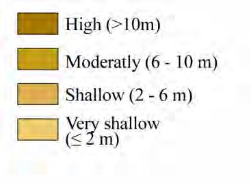
2 Observed major landslide types La Valette Faucon, 1996 slow-moving mudslide Faucon, 2003 fast-moving muddy debris-flow 2
3 Aim of this talk 1/ Characteristics of the Barcelonnette Basin: a multi-hazard prone area - Geomorphology and geology - Landuse - Climate 2/ Some statistics on the processes creating risks 3/ Practical examples of risk management - management of debris flow risks - management of the risk associated to large mudslides - example of risk zonation plans 4/ Conclusions 3
4 4 STUDY SITE BARCELONNETTE BASIN (South East French Alps)

5 Several favourable predisposing factors for slope instability Geomorphological features 5

6 Several favourable predisposing factors for slope instability 6 A geological window outcropping the clay shale bedrock


7 Several favourable predisposing factors for slope instability 7 A susceptible sedimentary tectonized bedrock


8 Several favourable predisposing factors for slope instability Glacial cirque 8 The influence of glaciation in the landscape Discontinuous morainic deposits
 intense")
9 Several favourable predisposing factors for slope instability An evolving landuse: intense deforestation in the 19 th century (agro-pastoral communities) intense gullying 9
 intense landsliding")
10 Several favourable predisposing factors for slope instability 1893 An evolving landuse: intense deforestation in the 19 th century (agro-pastoral communities) intense landsliding 10


11 Several favourable predisposing factors for slope instability 1897 An evolving landuse: during the 20 th century, intense reforestation for torrential control 2003


12 Several favourable predisposing factors for slope instability An evolving landuse: during the 20 th century, intense reforestation for torrential control


13 The actual landscape: contrast South/North slopes South-facing slope: high energy relief - intense gullying discontinuous morainic cover W E North-facing slope: landsliding high thickness morainic cover E 13 W
 - Presence of a snowpack on the upper slopes (> 1900m) for 4 to 6 months - intense thunderstorms I max > 50 mm.")
14 A favourable climate for slope instability Alpine climate with Mediterranean influence - High inter annual rainfall variability (735 mm ± 400 mm; ) - Mean annual temperature: 7.5 ± 1.3 ; ) - Presence of a snowpack on the upper slopes (> 1900m) for 4 to 6 months - intense thunderstorms I max > 50 mm.h -1 14
 Type B: heavy")
15 Climate Landslide relationships ( ) Archive investigation and dendrochronological analyses at several time scales - Annual time scale: periods of landslide activity are correlated to excess yearly rainfall amounts, but landslide events are also observed in relatively dry periods - Daily time scale: 2 types of climate situations Type A: heavy daily rain (shallow slides) Type B: heavy 30-days rain (deep-seated slides) 15
16 16 SOME STATISTICS ON THE HAZARDS
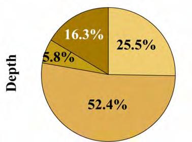
 Source: ONF-RTM database & regional archive Distribution")

17 Observed natural hazards since 1850 Flageollet et al., 1994 (Teslec) Source: ONF-RTM database & regional archive Distribution of landslide types Distribution of flood types 17 Major problems: - exhaustivity of the database - approximative dating - wrong identification of the type of process


18 Inventory of landslide types ca. 60% ca. 42% Translationnal (Faucon) Active rotational (Poche torrent) ca. 75% Relict rotational (Poche torrent) 18

19 19 Landslide maps
Considerations on debris-flow hazard analysis, risk assessment and management.
 European Geosciences Union General Assembly 2008, 14-18 April, Vienna Considerations on debris-flow hazard analysis, risk assessment and management. A. Remaître 1, J.-P. Malet 1, O. Maquaire 2 1. CNRS
MANAGEMENT OF LARGE MUDSLIDES
 36 MANAGEMENT OF LARGE MUDSLIDES Three large and active mudslides Poche, 1860?, Super-Sauze, 1960?, La Valette, March 1982, 1 M m 3 900,000 m 3 4-5 M m 3 37 Three large and active mudslides Type of development:
Assistant in the Geomatic and risk analysis institute (IGAR) and Geophysical institute (IG), University of Lausanne
 and Geophysical institute (IG), University of Lausanne") Who am I? That is the question Travelletti Julien Nationality: Swiss Date of birth: 24.10.1980 Master in engineering geology, University of Lausanne, Switzerland, 2007 «Large-scale landslide and debris
Who am I? That is the question Travelletti Julien Nationality: Swiss Date of birth: 24.10.1980 Master in engineering geology, University of Lausanne, Switzerland, 2007 «Large-scale landslide and debris
Emergency preparedness tools for landslides
 http://omiv.unistra.fr Emergency preparedness tools for landslides A. Remaître, J.-P. Malet, S. Sterlacchinni, A. Pasuto Institut de Physique du Globe, Université de Strasbourg, Strasbourg, France CERG,
Geodetic monitoring of the Adroit landslide, Barcelonnette, French Southern Alps
 Geodetic monitoring of the Adroit landslide, Barcelonnette, French Southern Alps Gilbert FERHAT 1, Jean-Philippe MALET 1, Anne PUISSANT 2, Delphine CAUBET 3, Emilie HUBER 3 1 Institut de Physique du Globe
Landslide susceptibility mapping at 1:1M scale over France: exploratory results with a heuristic model
 Landslide susceptibility mapping at 1:1M scale over France: exploratory results with a heuristic model J.-P. Malet & Y. Thiery CNRS UMR 7516, School and Observatory of Earth Sciences, University of Strasbourg,
SPATIAL MODELS FOR THE DEFINITION OF LANDSLIDE SUSCEPTIBILITY AND LANDSLIDE HAZARD. J.L. Zêzere Centre of Geographical Studies University of Lisbon
 SPATIAL MODELS FOR THE DEFINITION OF LANDSLIDE SUSCEPTIBILITY AND LANDSLIDE HAZARD J.L. Zêzere Centre of Geographical Studies University of Lisbon CONCEPTUAL MODEL OF LANDSLIDE RISK Dangerous Phenomena
Landslides in a Multi-Hazard context
 Proceedings of the Second World Landslide Forum 3-7 October 2011, Rome Melanie S. Kappes (1), Thomas Glade (2) Landslides in a Multi-Hazard context (1) University of Vienna, Geomorphic Systems and Risk
RISK ASSESSMENT METHODOLOGIES FOR LANDSLIDES
 RISK ASSESSMENT METHODOLOGIES FOR LANDSLIDES Jean-Philippe MALET Olivier MAQUAIRE CNRS & CERG. Welcome to Paris! 1 Landslide RAMs Landslide RAM A method based on the use of available information to estimate
LAND DEGRADATION IN THE CARIBBEAN: QUATERNARY GEOLOGICAL PROCESSES. RAFI AHMAD
 EXTENDED TASK FORCE MEETING OF PARTICIPATING AGENCIES AND LATIN AMERICAN COUNTRIES FOR ENHANCING SOUTH-SOUTH COOPERATION BETWEEN LAC-CARIBBEAN SIDS PARTNERSHIP INITIATIVE ON LAND DEGRADATION AND SUSTAINABLE
Need of Proper Development in Hilly Urban Areas to Avoid
 Need of Proper Development in Hilly Urban Areas to Avoid Landslide Hazard Dr. Arvind Phukan, P.E. Cosultant/Former Professor of Civil Engineering University of Alaska, Anchorage, USA RI District Governor
Landslide susceptibility assessment by bivariate methods at large scales: Application to a complex mountainous environment
 Landslide susceptibility assessment by bivariate methods at large scales: Application to a complex mountainous environment Yannick Thiery, Jean-Philippe Malet, Simone Sterlacchini, Anne Puissant, Olivier
1 Introduction. Keywords. Landslide monitoring, GNSS, camera, LiDAR
 The French National Landslide Observatory OMIV Monitoring surface displacement using permanent GNSS, photogrammetric cameras and terrestrial LiDAR for understanding the landslide mechanisms J.-P. Malet,
Morphology and sedimentology of a complex debris flow in a clay-shale basin
 Earth Surface Processes and Landforms Morphology Earth Surf. Process. and sedimentology Landforms 30, of 339 a debris 348 (2005) flow 339 Published online in Wiley InterScience (www.interscience.wiley.com).
Regional assessment of debris flow impacts on transport infrastructures
 Regional assessment of debris flow impacts on transport infrastructures Debris flows may have dramatic consequences for the security of transport infrastructures in mountainous regions. Each year in the
Analysis of soil failure modes using flume tests
 Analysis of soil failure modes using flume tests A. Spickermann & J.-P. Malet CNRS UMR 7516, School and Observatory of Earth Sciences, University of Strasbourg, Strasbourg, France Th.W.J. van Asch, M.C.G.
APPROACH TO THE SPANISH WATER ORGANISATION IMPROVING FLOOD HAZARD MAPPING, LAWS AND AUTHORITIES COORDINATION
 "Workshop On Land Use Planning And Water Management, With Focus On Flood Risk Management Oslo, Norway. Wednesday 31 January and Thursday 1 February 2007 APPROACH TO THE SPANISH WATER ORGANISATION IMPROVING
Natural Terrain Risk Management in Hong Kong
 Natural Terrain Risk Management in Hong Kong Nick Koor Senior Lecturer in Engineering Geology School of Earth and Environmental Sciences Slope failures in Hong Kong Man-made Slope Failure - 300 landslides
Geomorphology and Landslide Hazard Models
 Geomorphology and Landslide Hazard Models Steve Parry GeoRisk Solutions Key component of interpreting geomorphology and therefore hazard at a site is the use of API The purpose of this talk is not to try
A Roundup of Recent Debris Flow Events in Taiwan
 2015 International Workshop on Typhoon and Flood APEC Experience Sharing on Hazardous Weather Events and Risk Management A Roundup of Recent Debris Flow Events in Taiwan Hsiao-Yuan(Samuel) Yin Ph.D. sammya@mail.swcb.gov.tw
The sketch map of field investigations in Wenchuan earthquake hit region, Chengdu City.
 The sketch map of field investigations in Wenchuan earthquake hit region, Chengdu City. 1 Environmental and Geological Condition 1.1 Geomorphology BaiSha River Basin is located in Dujiangyan County, and
Office National des Forêts, Service de Restauration des Terrains en Montagne de l Isère, 9 quai Créqui, F Grenoble, France
 DOI: 10.4408/IJEGE.2011-03.B-100 Analysis of the debris-flow hazard on the Rioulong torrent (Hautes-Pyrénées, France) alluvial fan using a scenario-based approach Dominique Laigle (*) & Christophe Peteuil
Lecture Outlines PowerPoint. Chapter 6 Earth Science 11e Tarbuck/Lutgens
 Lecture Outlines PowerPoint Chapter 6 Earth Science 11e Tarbuck/Lutgens 2006 Pearson Prentice Hall This work is protected by United States copyright laws and is provided solely for the use of instructors
Geology 101. Reading Guides for Chapters 5 and 14 Weathering: the Breakdown of Rocks (p. 142)
") Geology 101 Name Reading Guides for Chapters 5 and 14 Weathering: the Breakdown of Rocks (p. 142) Please read the introduction to the chapter. What is the difference between weathering and erosion? Weathering
Geology 101 Name Reading Guides for Chapters 5 and 14 Weathering: the Breakdown of Rocks (p. 142) Please read the introduction to the chapter. What is the difference between weathering and erosion? Weathering
Harmonised approaches for landslide susceptibility mapping in Europe
 Harmonised approaches for landslide susceptibility mapping in Europe J. Hervás Institute for Environment and Sustainability, Joint Research Centre (JRC), European Commission, Ispra, Italy A. Günther Federal
Geology 101. Reading Guides for Chapters 6 and 12
 Geology 101 Name Chapter 6: Weathering and Soils (p. 160): Reading Guides for Chapters 6 and 12 This chapter is about the processes involved in the disintegration of rock. Weathering is often mistaken
Flow behaviour and runout modelling of a complex debris flow in a clay-shale basin
 Earth Surface Processes and Landforms Flow Earth behaviour Surf. Process. and Landforms runout modelling 30, 479 488 (2005) 479 Published online in Wiley InterScience (www.interscience.wiley.com). DOI:
Bell Ringer. Are soil and dirt the same material? In your explanation be sure to talk about plants.
 Bell Ringer Are soil and dirt the same material? In your explanation be sure to talk about plants. 5.3 Mass Movements Triggers of Mass Movements The transfer of rock and soil downslope due to gravity is
INTRODUCTION. Climate
 INTRODUCTION Climate Landslides are serious natural disasters in many parts of the world. Since the past 30 years, rainfall triggered landslides and debris flows had been one of the natural disasters of
Geomorphology for Engineers
 Geomorphology for Engineers Edited by P. G. Fookes, E. M. Lee and G. Milligan Whittles Publishing CRC PRESS Contents Foreword Preface Dedication Biographies 1. Introduction to Engineering Geomorphology
THE 3-REGIONS WORKING GROUP SLOPE INSTABILITIES (SlopeIn)
") Bayerisches Landesamt für Umwelt THE 3-REGIONS WORKING GROUP SLOPE INSTABILITIES (SlopeIn) COMMON LANGUAGE, COMPARABLE HAZARD MAPPING AND SHARED EXPERIENCES ACROSS EUROPE The 3-Regions Working-Group SlopeIn:
Bayerisches Landesamt für Umwelt THE 3-REGIONS WORKING GROUP SLOPE INSTABILITIES (SlopeIn) COMMON LANGUAGE, COMPARABLE HAZARD MAPPING AND SHARED EXPERIENCES ACROSS EUROPE The 3-Regions Working-Group SlopeIn:
INDICATIVE HAZARD MAPS FOR LANDSLIDES IN STYRIA; AUSTRIA
 DOI: https://doi.org/10.18509/agb.2016.10 UDC:528.88:551.311.24(436) COBISS: INDICATIVE HAZARD MAPS FOR LANDSLIDES IN STYRIA; AUSTRIA Herwig Proske 1 & Christian Bauer 1/2 1 Joanneum Research, Graz, Austria
京都大学防災研究所年報第 54 号 B 平成 23 年 6 月 Annuals of Disas. Prev. Res. Inst., Kyoto Univ., No. 54 B, 2011 Possible Scenarios for Rjecina River Catchment on the
 京都大学防災研究所年報第 54 号 B 平成 23 年 6 月 Annuals of Disas. Prev. Res. Inst., Kyoto Univ., No. 54 B, 211 Possible Scenarios for Rjecina River Catchment on the Example of Grohovo Landslide Maja OSTRIC*, Yosuke YAMASHIKI,
Analysis of soil failure modes using flume tests
 Analysis of soil failure modes using flume tests A. Spickermann & J.-P. Malet Institute of Earth Physics, CNRS UMR 751, University of Strasbourg, Strasbourg, France Th.W.J. van Asch, M.C.G. van Maarseveen,
Haydar Hussin (1), Roxana Ciurean (2), Paola Reichenbach (1), Cees van Westen (3), Gianluca Marcato (4), Simone Frigerio (4), V. Juliette Cortes (4)
, Roxana Ciurean (2), Paola Reichenbach (1), Cees van Westen (3), Gianluca Marcato (4), Simone Frigerio (4), V. Juliette Cortes (4)") 7/10/2013 Changing Hydro-meteorological Risks - as Analyzed by a New Generation of European Scientists Probabilistic 2D numerical landslide modeling: a first step towards assessing changes in risk due
7/10/2013 Changing Hydro-meteorological Risks - as Analyzed by a New Generation of European Scientists Probabilistic 2D numerical landslide modeling: a first step towards assessing changes in risk due
Test of Fuzzy Logic Rules for Landslide Susceptibility Assessment
 Test of Fuzzy Logic Rules for Landslide Susceptibility Assessment Yannick Thiery, Jean-Philippe Malet, Olivier Maquaire To cite this version: Yannick Thiery, Jean-Philippe Malet, Olivier Maquaire. Test
Gully erosion and associated risks in the Tutova basin Moldavian Plateau
 Landform Analysis, Vol. 17: 193 197 (2011) Gully erosion and associated risks in the Tutova basin Moldavian Plateau University Alexandru Ioan Cuza of Iasi, Department of Geography, Romania, e-mail: catiul@yahoo.com
Mapping Landslide Events in Vietnam Using the Global Landslide Catalog and GIS
 Mapping Landslide Events in Vietnam Using the Global Landslide Catalog and GIS Minh NGUYEN DINH, Huong NGUYEN, Vietnam Key words: mapping, landslide events, Vietnam, global landslide catalog, GIS SUMMARY
Preparing Landslide Inventory Maps using Virtual Globes
 Introduction: A landslide is the movement of a mass of rock, debris, or earth down a slope, under the influence of gravity. Landslides can be caused by different phenomena, including intense or prolonged
STUDY GUIDE FOR CONTENT MASTERY. Surface Water Movement
 Surface Water SECTION 9.1 Surface Water Movement In your textbook, read about surface water and the way in which it moves sediment. Complete each statement. 1. An excessive amount of water flowing downslope
Landslide Susceptibility Model of Tualatin Mountains, Portland Oregon. By Tim Cassese and Colby Lawrence December 10, 2015
 Landslide Susceptibility Model of Tualatin Mountains, Portland Oregon By Tim Cassese and Colby Lawrence December 10, 2015 Landslide Closes Highway 30 at St. John's Bridge Introduction: Study Area: Tualatin
OBSERVING AND MAPPING THE ROCK STREAMS AND QUARRIES IN SOME MASSIFS FROM THE ROMANIAN CARPATHIANS BY MEANS OF SATELLITE IMAGES
 VASILE LOGHIN 371 OBSERVING AND MAPPING THE ROCK STREAMS AND QUARRIES IN SOME MASSIFS FROM THE ROMANIAN CARPATHIANS BY MEANS OF SATELLITE IMAGES Key words: rock streams, quarries, satellite images, Carpathians
AN APPROACH TO THE CLASSIFICATION OF SLOPE MOVEMENTS
 Training/workshop on Earthquake Vulnerability and Multi-Hazard Risk Assessment: Geospatial Tools for Rehabilitation and Reconstruction Effort 13 31 March 2006, Islamabad, Pakistan AN APPROACH TO THE CLASSIFICATION
THE NEW DNR LANDSLIDE HAZARDS PROGRAM
 THE NEW DNR LANDSLIDE HAZARDS PROGRAM Kara Jacobacci, G.I.T. Landslide Hazards Program Washington Geological Survey Washington Department of Natural Resources LEGISLATIVE FUNDING 2015 session DNR requested
Urban storm water management
 Urban storm water management Cooperation between geologists and land-use planners Philipp Schmidt-Thomé Geological Survey of Finland Background Urban flood modeling has become more topical during 21 st
VULNERABILITY OF WATER SUPPLY TO NATURAL HAZARDS IN JAMAICA
 VULNERABILITY OF WATER SUPPLY TO NATURAL HAZARDS IN JAMAICA RAFI AHMAD rafi.ahmad@uwimona.edu.jm Unit for disaster studies, Department of Geography & Geology, The University of the West Indies, Mona Kingston
Chapter 5: Glaciers and Deserts
 I. Glaciers and Glaciation Chapter 5: Glaciers and Deserts A. A thick mass of ice that forms over land from the compaction and recrystallization of snow and shows evidence of past or present flow B. Types
Weathering, Erosion and Deposition
 Weathering, Erosion and Deposition Shaping the Earth s Surface Weathering the process of breaking down rocks into smaller fragments Erosion the transport of rock fragments from one location to another
Pinyol, Jordi González, Marta Oller, Pere Corominas, Jordi Martínez, Pere
 Rockfall hazard mapping methodology applied to the Geological Hazard Prevention Map in Catalonia 1:25000 Pinyol, Jordi González, Marta Oller, Pere Corominas, Jordi Martínez, Pere ROCKFALL HAZARD MAPPING
Statistical Seismic Landslide Hazard Analysis: an Example from Taiwan
 Statistical Seismic Landslide Hazard Analysis: an Example from Taiwan Chyi-Tyi Lee Graduate Institute of Applied Geology, National Central University, Taiwan Seismology Forum 27: Natural Hazards and Surface
3/3/2013. The hydro cycle water returns from the sea. All "toilet to tap." Introduction to Environmental Geology, 5e
 Introduction to Environmental Geology, 5e Running Water: summary in haiku form Edward A. Keller Chapter 9 Rivers and Flooding Lecture Presentation prepared by X. Mara Chen, Salisbury University The hydro
ECOSYSTEM-BASED MEASURES FOR REDUCING SHALLOW LANDSLIDES RISK IN SLOPING TERRAIN
 ECOSYSTEM-BASED MEASURES FOR REDUCING SHALLOW LANDSLIDES RISK IN SLOPING TERRAIN ANALIA GUACHALLA TERRAZAS FEBRUARY, 2016 SUPERVISORS: Dr. L.L.J.M. Willemen Drs. J.M. Looijen ECOSYSTEM-BASED MEASURES FOR
Chapter 11 10/30/2013. Mass Wasting. Introduction. Factors That Influence Mass Wasting. Introduction. Factors That Influence Mass Wasting
 Introduction Chapter 11 Mass wasting - The downslope movement of material resulting from the force of gravity. Mass Wasting Mass wasting results when the force of gravity acting on a slope exceeds the
EFFECTS OF GLOBAL WARMING ON LANDSLIDE FREQUENCIES IN RATNAPURA DISTRICT, SRI LANKA- 2011
 EFFECTS OF GLOBAL WARMING ON LANDSLIDE FREQUENCIES IN RATNAPURA DISTRICT, SRI LANKA- 2011 T. D. Rathnaweera, Student, (Email: tdr19862142@gmail.com) U. P. Nawagamuwa,Senior Lecturer, (Email: udeni@uom.lk)
Estimation of landslides activities evolution due to land use changes in a Pyrenean valley
 Estimation of landslides activities evolution due to land use changes in a Pyrenean valley R. Vandromme, N. Desramaut, S. Bernardie, G. Grandjean 1 Introduction (1) > Need to produce dynamic susceptibility
The elevations on the interior plateau generally vary between 300 and 650 meters with
 11 2. HYDROLOGICAL SETTING 2.1 Physical Features and Relief Labrador is bounded in the east by the Labrador Sea (Atlantic Ocean), in the west by the watershed divide, and in the south, for the most part,
CASE STUDY #9 - Brushy Fork Dam, Sugar Grove, West Virginia
 CASE STUDY #9 - Brushy Fork Dam, Sugar Grove, West Virginia Brushy Fork Dam is a flood control structure built by the Soil Conservation Service southeast of the city of Franklin in Pendleton County, West
Simulation of heavy precipitation events with the COSMO model
 LM User Seminar, 6 March 2007, Langen Federal Department of Home Affairs FDHA Federal Office of Meteorology and Climatology MeteoSwiss Simulation of heavy precipitation events with the COSMO model Silke
UPDATING THE LANDSLIDE HAZARD ASSESSMENT SYSTEM WITHIN THE CITY OF THE GOLD COAST
 UPDATING THE LANDSLIDE HAZARD ASSESSMENT SYSTEM WITHIN THE CITY OF THE GOLD COAST Patrick Kidd Geotechnical Manager, SMEC Australia, Gold Coast, Queensland, Australia ABSTRACT The City of Gold Coast has
Innovative Ways to Monitor Land Displacement
 ARTICLE Innovative Ways to Monitor Land Displacement When people think about landslides, they usually imagine large mud streams which cause considerable loss of life. Whereas such large-scale disasters
Practical reliability approach to urban slope stability
 University of Wollongong Research Online Faculty of Engineering - Papers (Archive) Faculty of Engineering and Information Sciences 2011 Practical reliability approach to urban slope stability R. Chowdhury
Chapter 2. Wearing Down Landforms: Rivers and Ice. Physical Weathering
 Chapter 2 Wearing Down Landforms: Rivers and Ice Physical Weathering Weathering vs. Erosion Weathering is the breakdown of rock and minerals. Erosion is a two fold process that starts with 1) breakdown
Land recycling and reusing: man made terraces as a peculiar problem in the Liguria region.
 Land recycling and reusing: man made terraces as a peculiar problem in the Liguria region. G. Brancucci and G. Paliaga & Francesca Nervi POLIS Department University of Genova - Italy The Ligurian territory
Debris flow: categories, characteristics, hazard assessment, mitigation measures. Hariklia D. SKILODIMOU, George D. BATHRELLOS
 Debris flow: categories, characteristics, hazard assessment, mitigation measures Hariklia D. SKILODIMOU, George D. BATHRELLOS Natural hazards: physical phenomena, active in geological time capable of producing
Page 1. Name:
 Name: 1) Which event is the best example of erosion? dissolving of rock particles on a limestone gravestone by acid rain breaking apart of shale as a result of water freezing in a crack rolling of a pebble
Prentice Hall EARTH SCIENCE
 Prentice Hall EARTH SCIENCE Tarbuck Lutgens Chapter 7 Glaciers, Desert, and Wind 7.1 Glaciers Types of Glaciers A glacier is a thick ice mass that forms above the snowline over hundreds or thousands of
Eagle Creek Post Fire Erosion Hazard Analysis Using the WEPP Model. John Rogers & Lauren McKinney
 Eagle Creek Post Fire Erosion Hazard Analysis Using the WEPP Model John Rogers & Lauren McKinney Columbia River Gorge at Risk: Using LiDAR and GIS-based predictive modeling for regional-scale erosion susceptibility
About the present study
 About the present study This study presents results obtained under the project Models of contemporary Periglacial Morphogenesis a first stage of Bulgarian Periglacial Programme a programme for observation
Effects of climate change on landslide frequencies in landslide prone districts in Sri Lanka; Overview
 Effects of climate change on landslide frequencies in landslide prone districts in Sri Lanka; Overview T. D. Rathnaweera 1)., M. P. Palihawadana 2)., H. L. L. Rangana 3). and Dr. U. P. Nawagamuwa 4). Abstract
Time allowed: 1 hour 30 minutes
 SPECIMEN ASSESSMENT MATERIAL: SET 2 GCSE GEOGRAPHY Paper 1 Living with the physical environment Specimen Materials For this paper you must have: a pencil a ruler. Time allowed: 1 hour 30 minutes Instructions
Improvement of Hazard Assessment and Management in the Philippines
 Improvement of Hazard Assessment and Management in the Philippines (2014 Summer Training Course for Slope Land Disaster Reduction) Ian Alejandrino (Philippines) Nguyen Manh Hieu (Vietnam) Presentation
Erosion and Deposition
 Erosion and Deposition Erosion Sediment natural forces move rock/soil from one place to another. gravity, water, wind, glaciers, waves are causes material moved by erosion Deposition when erosion lays
International Symposium on Natural Disaster Mitigation. Local vulnerability assessment of landslides and debris flows
 International Symposium on Natural Disaster Mitigation of landslides and debris flows Lessons learnt from Cam Pha town and Van Don district, Quang Ninh province, Vietnam Nguyen Quoc Phi Faculty of Environment
Multi Hazard Evaluation of a High Voltage Transmission Network. John Eidinger 1 and Leon Kempner 2
 Multi Hazard Evaluation of a High Voltage Transmission Network John Eidinger 1 and Leon Kempner 2 1 G&E Engineering Systems Inc., P. O. Box 3592 Olympic Valley, CA 96146-3592; eidinger@earthlink.net. 2
Natural hazards in Glenorchy Summary Report May 2010
 Natural hazards in Glenorchy Summary Report May 2010 Contents Glenorchy s hazardscape Environment setting Flood hazard Earthquakes and seismic hazards Hazards Mass movement Summary Glossary Introduction
GEOSPATIAL ANALYSIS OF GLACIAL DYNAMICS OF SHIGAR AND SHAYOK BASINS. Syed Naseem Abbas Gilany 1
 GEOSPATIAL ANALYSIS OF GLACIAL DYNAMICS OF SHIGAR AND SHAYOK BASINS 1 OUTLINE Introduction Problem Statement / Rationale Objectives Material and Methods Study Area Datasets Required Data Analysis / Assessment
Landslide Hazard Zonation Methods: A Critical Review
 International Journal of Civil Engineering Research. ISSN 2278-3652 Volume 5, Number 3 (2014), pp. 215-220 Research India Publications http://www.ripublication.com/ijcer.htm Landslide Hazard Zonation Methods:
LANDSLIDE HAZARDS. presented during the. TRAINING-WORKSHOP ON DISASTER RISK MANAGEMENT Rakdell Inn Virac, Catanduanes 03 July 2008
 LANDSLIDE HAZARDS presented during the TRAINING-WORKSHOP ON DISASTER RISK MANAGEMENT Rakdell Inn Virac, Catanduanes 03 July 2008 GEOLOGIC HAZARDS the probability of occurrence, within a specific period
Down-stream process transition (f (q s ) = 1)
 = 1)") Down-stream process transition (f (q s ) = 1) Detachment Limited S d >> S t Transport Limited Channel Gradient (m/m) 10-1 Stochastic Variation { Detachment Limited Equilibrium Slope S d = k sd A -θ d S
Down-stream process transition (f (q s ) = 1) Detachment Limited S d >> S t Transport Limited Channel Gradient (m/m) 10-1 Stochastic Variation { Detachment Limited Equilibrium Slope S d = k sd A -θ d S
NATURAL HAZARDS PROFILE OF JAMAICA RAFI AHMAD
 NATURAL HAZARDS PROFILE OF JAMAICA RAFI AHMAD rafi.ahmad@uwimona.edu.jm UNIT FOR DISASTER STUDIES DEPARTMENT OF GEOGRAPHY AND GEOLOGY Tel. 1-876-927-2728/2129 Fax: 1-876-977-6029 THE UNIVERSITY OF THE
Clyde River Landslide
 Clyde River Landslide Department of Geology, Perkins Hall, University of Vermont, Burlington, VT 05405 Abstract: This paper investigates a landslide on the Clyde River in Newport, Vermont. The landslide
Effect of land cover / use change on soil erosion assessment in Dubračina catchment (Croatia)
") European Water 57: 171-177, 2017. 2017 E.W. Publications Effect of land cover / use change on soil erosion assessment in Dubračina catchment (Croatia) N. Dragičević *, B. Karleuša and N. Ožanić Faculty
European Water 57: 171-177, 2017. 2017 E.W. Publications Effect of land cover / use change on soil erosion assessment in Dubračina catchment (Croatia) N. Dragičević *, B. Karleuša and N. Ožanić Faculty
OIKOS > landslide > mechanism >predisposing causes
 predisposing causes and trigger OIKOS > landslide > mechanism >predisposing causes Landslides are events that occur in space and time. As such, it is usually possible to identify both one or more landslide
Flooding in Western North Carolina: Some Spatial, Hydrologic, and Seasonal Characteristics CAUTION!! Outline. Basic Flood Facts.
 Flooding in Western North Carolina: Some Spatial, Hydrologic, and Seasonal Characteristics J. Greg Dobson CAUTION!! National Environmental Modeling and Analysis Center RENCI at UNC-Asheville Engagement
Climate Change Impact for Spatial Landslide Susceptibility
 Climate Change Impact for Spatial Landslide Susceptibility 82 Christine Gassner, Catrin Promper, Santiago Beguería and Thomas Glade Abstract Climate change is influencing future precipitation patterns.
THE SALZKAMMERGUT A SHORT HISTORIC OVERVIEW. Austrian Service for Torrent and Avalanche Control, June 11th.2018:
 THE SALZKAMMERGUT A SHORT HISTORIC OVERVIEW Austrian Service for Torrent and Avalanche Control, June 11th.2018: Situation and history: The name Salzkammergut originates from the salt mining and salt refinery
WATERCOURSE HARNESSING BANK EROSION AND CONSOLIDATION
 GUVERNUL MINISTERUL POSDRU MUNCII, FAMILIEI ŞI WATERCOURSE HARNESSING BANK EROSION AND CONSOLIDATION PhD. student: ALUPOAE Daniel Gheorghe Asachi Technical University of Iasi, Faculty of Civil Engineering
Vulnerability mapping for sustainable hazard mitigation in the city of Bukavu, South Kivu DRCongo
 IAG/AIG REGIONAL CONFERENCE, 18th to 22nd Feb. 2011 Vulnerability mapping for sustainable hazard mitigation in the city of Bukavu, South Kivu DRCongo Sadiki Ndyanabo 1, Ine Vandecasteele 2, Jan Moeyersons
MODELLING FROST RISK IN APPLE TREE, IRAN. Mohammad Rahimi
 WMO Regional Seminar on strategic Capacity Development of National Meteorological and Hydrological Services in RA II (Opportunity and Challenges in 21th century) Tashkent, Uzbekistan, 3-4 December 2008
3/8/17. #20 - Landslides: Mitigation and Case Histories. Questions for Thought. Questions for Thought
 #20 - Landslides: Mitigation and Case Histories Web Exercise #3 (Volcanoes) Due Wednesday There is a 2-point penalty for every day the assignment is late. Exam 1 Scores Scores and exam key are posted Vaiont
ENVIRONMENTAL GEOSCIENCE UNIFORM SYLLABUS
 ENVIRONMENTAL GEOSCIENCE UNIFORM SYLLABUS The Association of Professional Engineers and Geoscientists of the Province of British Columbia Note: 1. This Syllabus May Be Subject To Change 2. These Courses
Mass Wasting. Revisit: Erosion, Transportation, and Deposition
 Mass Wasting Revisit: Erosion, Transportation, and Deposition While landslides are a normal part of erosion and surface processes, they can be very destructive to life and property! - Mass wasting: downslope
Geophysical techniques for investigating shallow and deep landslides: results in the framework of PREVIEW project (FP6 UE)
") Geophysical techniques for investigating shallow and deep landslides: results in the framework of PREVIEW project (FP6 UE) Perrone, A; Piscitelli, S; Lampenna, V; Lamporte, A; Giocolli, A; Dahlin, Torleif
Geophysical techniques for investigating shallow and deep landslides: results in the framework of PREVIEW project (FP6 UE) Perrone, A; Piscitelli, S; Lampenna, V; Lamporte, A; Giocolli, A; Dahlin, Torleif
Evaluation of Flash flood Events Using NWP Model and Remotely Sensed Rainfall Estimates
 Evaluation of Flash flood Events Using NWP Model and Remotely Sensed Rainfall Estimates Dr. Ismail Yucel METU Civil Engineering Department and Fatih Keskin State Hydraulic Works HydroPredict 2010 Prague
3D Slope Stability Analysis for Slope Failure Probability in Sangun mountainous, Fukuoka Prefecture, Japan
 3D Slope Stability Analysis for Slope Failure Probability in Sangun mountainous, Fukuoka Prefecture, Japan Hendra PACHRI (1), Yasuhiro MITANI (1), Hiro IKEMI (1), and Wenxiao JIANG (1) (1) Graduate School
9/13/2011 CHAPTER 9 AND SUBSIDENCE. Case History: La Conchita Landslide. Introduction
 CHAPTER 9 SLOPE PROCESSES, LANDSLIDES, AND SUBSIDENCE Case History: La Conchita Landslide La Conchita: small coastal community 80 km (50 mi) northwest of Los Angeles Landslide occurred on January 10, 2005
Earthquake-induced landslide distribution and hazard mapping. Megh Raj Dhital Central Department of Geology, Tribhuvan University
 Earthquake-induced landslide distribution and hazard mapping Megh Raj Dhital Central Department of Geology, Tribhuvan University Contents Geological setting of Gorkha earthquake Peak ground acceleration
Riverbank Landslides and the Probability Analysis of Landslide Dams
 International Journal of Structural and Civil Engineering Research Vol. 5, No. 3, August 2016 Riverbank Landslides and the Probability Analysis of Landslide Dams Chien-Yuan Chen and Wei-Ting Lee Dept.
9/23/2013. Introduction CHAPTER 7 SLOPE PROCESSES, LANDSLIDES, AND SUBSIDENCE. Case History: La Conchita Landslide
 Introduction CHAPTER 7 SLOPE PROCESSES, LANDSLIDES, AND SUBSIDENCE Landslide and other ground failures posting substantial damage and loss of life In U.S., average 25 50 deaths; damage more than $3.5 billion
Topographic Laser Scanning of Landslide Geomorphology System: Some Practical and Critical Issues
 Topographic Laser Scanning of Landslide Geomorphology System: Some Practical and Critical Issues Khamarrul Azahari Razak, Rozaimi Che Hasan UTM Razak School of Engineering and Advanced Technology, UTM