February 9, 2018 GeoInsight Project
|
|
|
- Stella Haynes
- 5 years ago
- Views:
Transcription

1 February 9, 2018 GeoInsight Project William Murphy, Director Town of Sudbury Board of Health 275 Old Lancaster Road Sudbury, MA Re: Focused Subsurface Investigation Melone Property North Road Sudbury, Massachusetts Dear Mr. Murphy: GeoInsight, Inc. (GeoInsight) is pleased to provide this Focused Subsurface Investigation Report (the Report) for the Melone property located on North Road in Sudbury, Massachusetts (the Property). The Report was completed in general accordance with our Scope of Work for Focused Subsurface Investigation (SOW) dated October 12, The Report summarizes the results of subsurface investigation activities conducted at the Property in November and December BACKGROUND The Property consists of an approximately 46.6-acre irregularly shaped parcel purchased by the Town of Sudbury (the Town) in The central and southwest portions of the Property are located in Sudbury. The northeast portion of the Property is located in the neighboring town of Concord. The properties to the west and northwest are the location of the former Sperry/Unisys facility which is a documented Commonwealth of Massachusetts hazardous materials release site. The Property is contiguous with an approximately 6.9-acre parcel of land to the east that is owned by the Sudbury Water District. The primary access to the Melone Property is through the Sudbury Water District parcel. GeoInsight was retained by the Town to conduct an environmental data review associated with the Melone Property. The results of the data review were presented to the Town in a Technical Memorandum dated June 9, The Technical Memorandum provided the Town with a general summary of the Sperry/Unisys Site, including a summary of constituents of concern (COCs) released, environmental media and areas impacted, and remedial activities. The memorandum also included summary information associated with Sudbury Water District and GeoInsight, Inc. 186 Granite Street, 3 rd Floor, Suite A Manchester, NH Tel (603) Fax (603) GeoInsight, Inc. One Monarch Drive, Suite 201 Littleton, MA Tel (978) Fax (978) GeoInsight, Inc. 200 Court Street, 2 nd Floor Middletown, CT Tel (860) Fax (860)
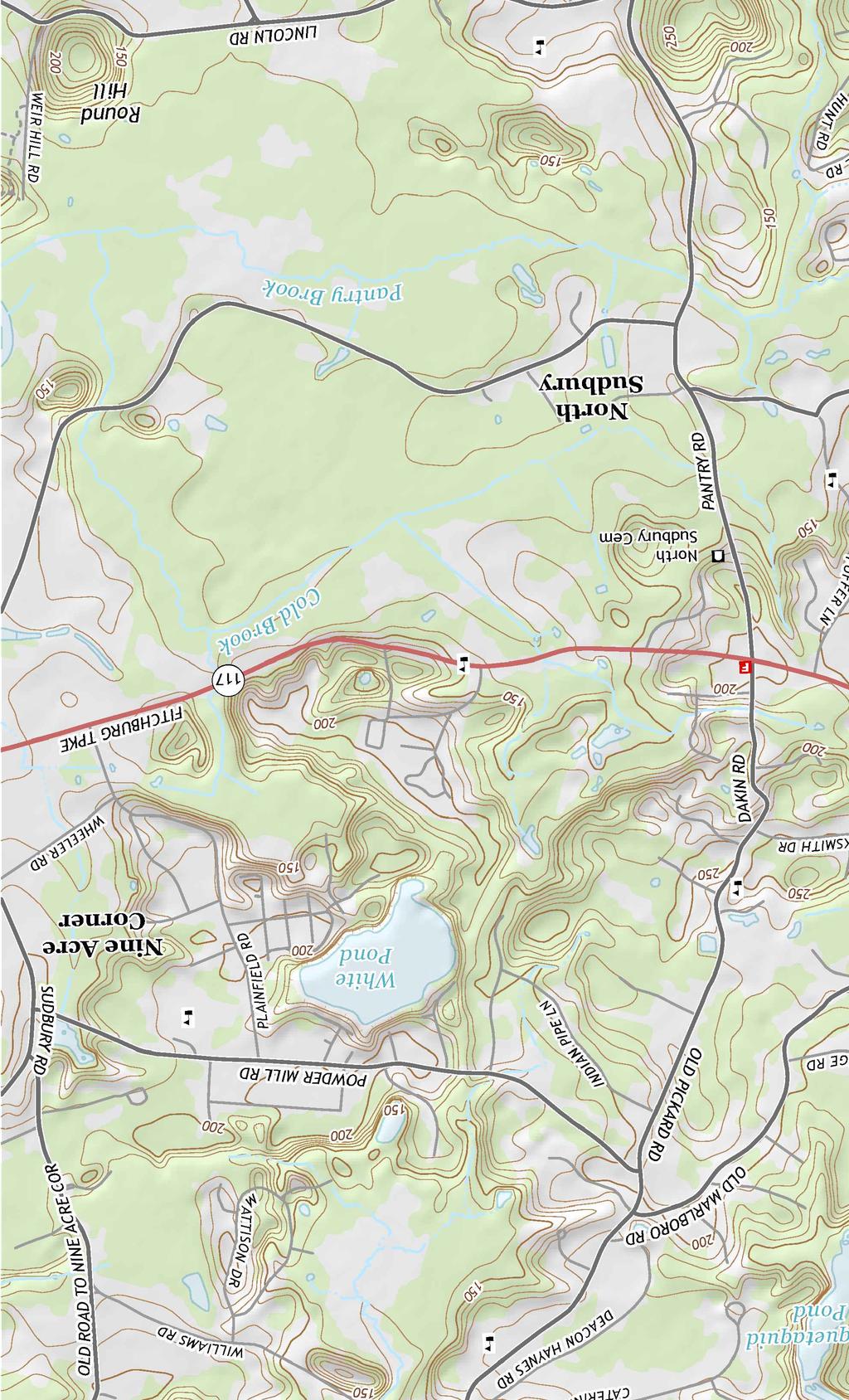
2 Town of Concord municipal water supply wells that are located near the Property. The Technical Memorandum also included redevelopment considerations to assist the Town in evaluating Property reuse options. SCOPE OF WORK The SOW was based upon information obtained during our focused review of conditions associated with the Sperry/Unisys Site, possible environmental considerations associated with future redevelopment of the Property, and discussions with representatives of the Town. We identified the following possible environmental considerations associated with future redevelopment of the Property. Soil Related: The non-gravel-mined western portion of the Melone Property was historically occupied by an orchard. Shallow soil located in this portion of the property may contain residues from historical application of pesticides/herbicides. Groundwater Related: There are no historical or current data for groundwater at the Melone Property. Available information suggests that impacts associated with the Sperry/Unisys Site Gravel Pit Area plume extended onto the north border and possibly the north portion of the Melone Property (i.e., the portion located in Concord). Because of their location, topography, and presence of wetlands, the areas that may have been historically impacted by the Gravel Pit Area plume are not likely the portions of the Melone Property to be considered for redevelopment. Available information suggests that impacts associated with the Sperry/Unisys Leach Field Area plume may extend onto the southwest and southern portions of the Melone Property. Historical chlorinated solvents that were detected in samples of deep overburden and shallow bedrock groundwater near Sudbury Water District Well No. 5 appeared to extend northward onto the Sudbury Water District land that abuts the east side of the Melone Property. The extent of these impacts was not delineated. Subsurface investigation activities performed on properties near the Melone Property indicate that soils consist of sand and gravel on top of a thin layer of glacial till and then bedrock. Depth to bedrock is variable but is generally within 20 to 50 feet of the ground surface. Depth to water varies depending upon topography but is generally within 5 to 10 feet of the ground surface. The southern portion of the Property that abuts North Road and the southwest conservation portion of the Property are heavily forested and are characterized by significant topographical February 9, 2018 GeoInsight Project Page 2
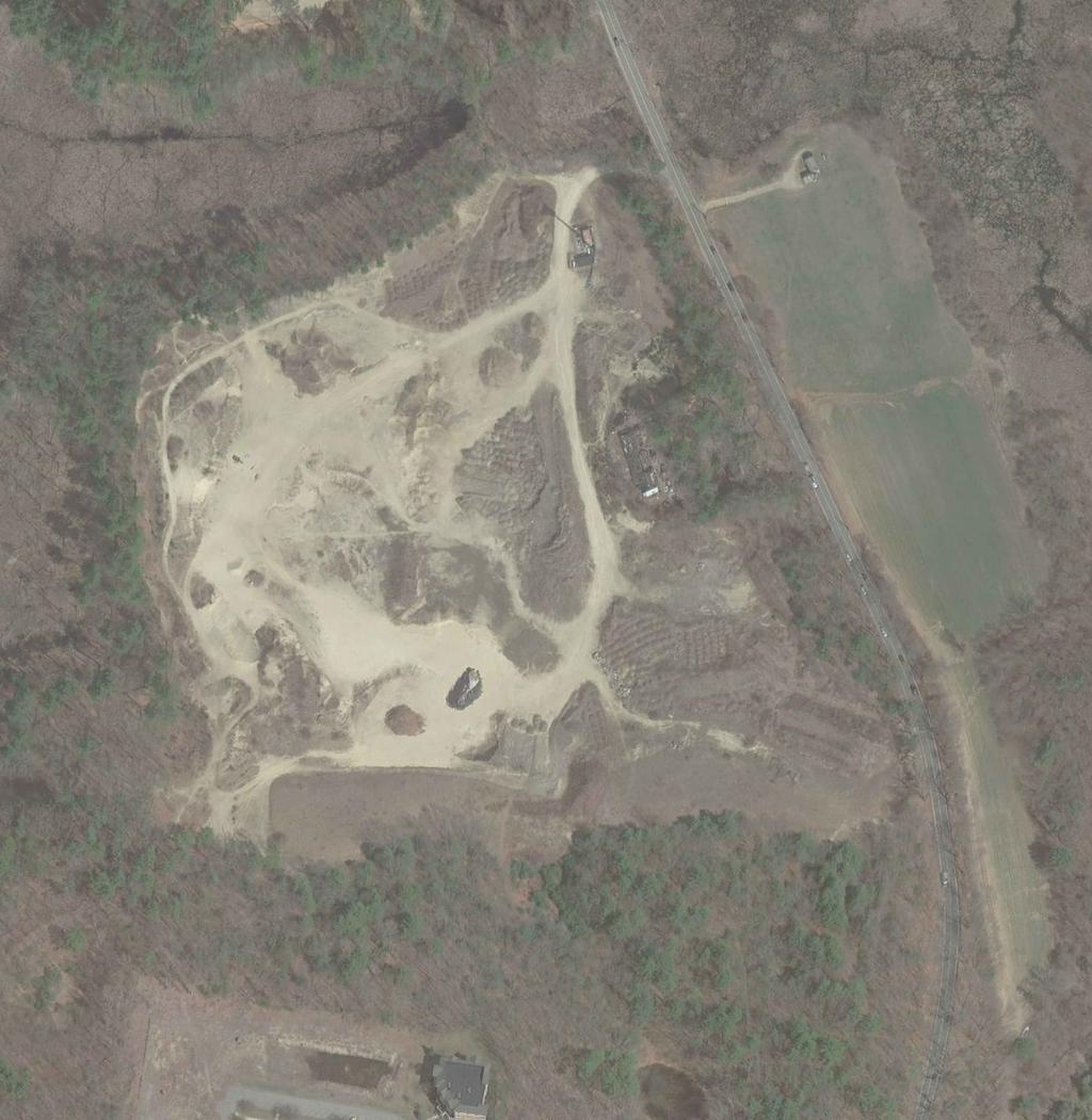
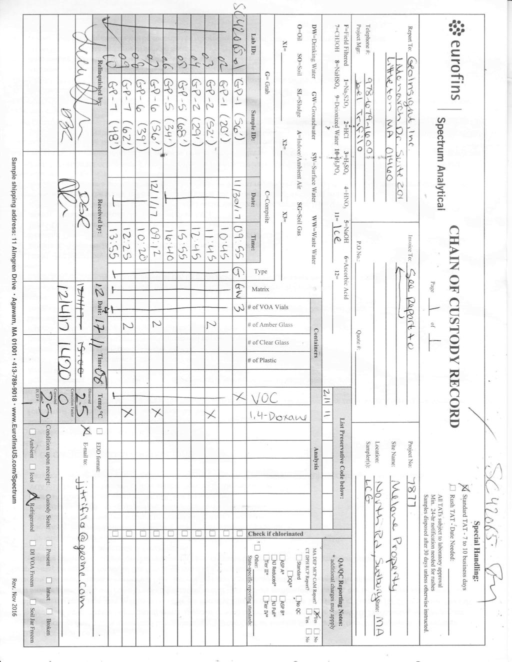
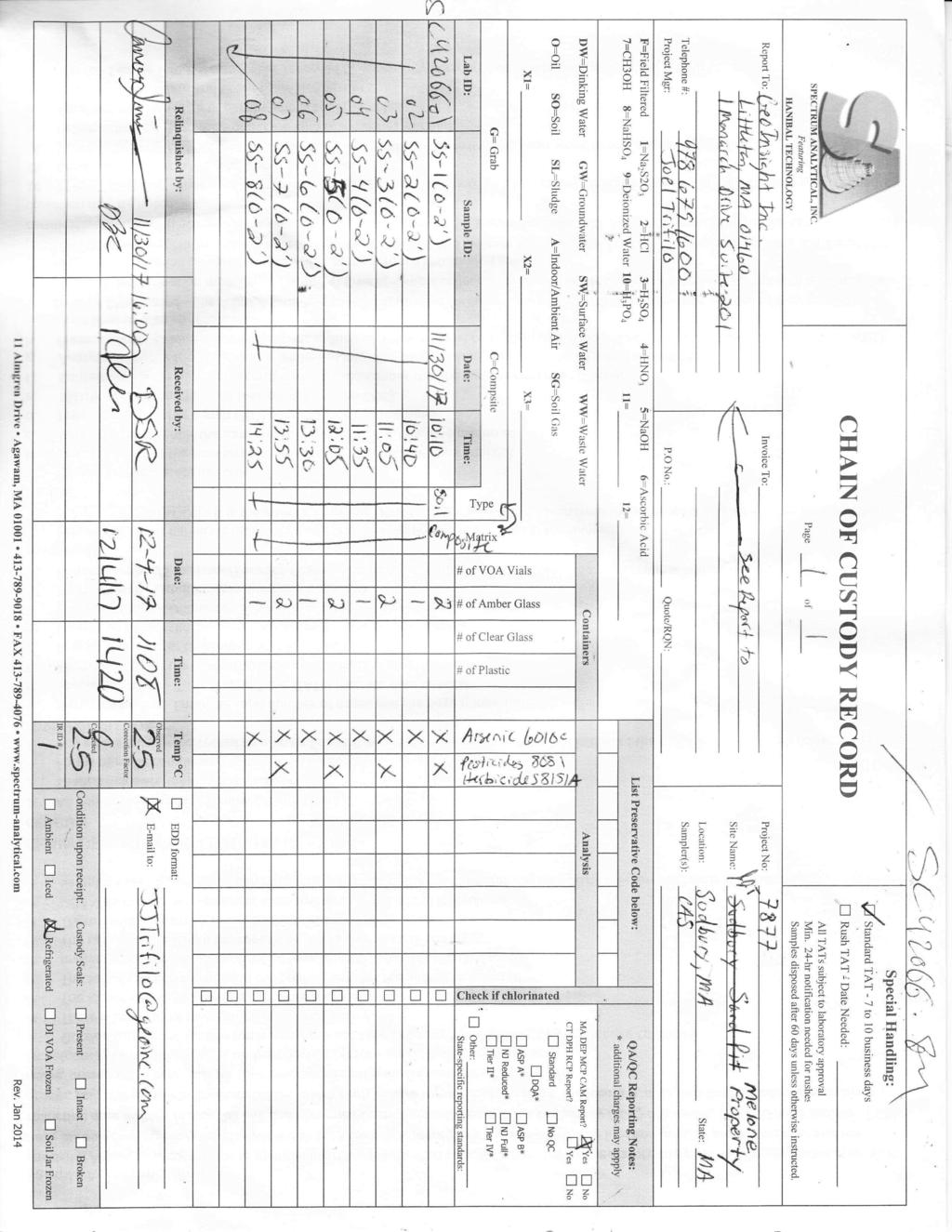
3 relief. Therefore, the SOW focused the groundwater characterization activities focused on the more readily accessible central and north portions of the Property. SCOPE OF WORK The following tasks were completed as part of the focused subsurface investigation at the Property. DIG-SAFE ACTIVITIES On November 21, 2017, GeoInsight conducted a Property visit to pre-mark the locations of proposed soil borings at the Property, and to look for and evaluate the presence/condition of historical monitoring wells that had previously been installed near the Property. GeoInsight identified two pre-existing monitoring wells (MW-2 and monitoring well cluster 91-S8 and 91-S9). Monitoring well MW-2 was installed in 1989 near the southwest corner of the Sudbury Water District property, adjacent to the Wagner property, as part of a subsurface investigation to evaluate chlorinated solvent impacts in Sudbury Well No. 5. Monitoring well cluster 91-S8 and 91-S9 was installed in 1991 off-property to the southeast of the Sudbury Water District property as part of historical investigations for the Sperry/Unisys Site. The locations of these wells are indicated on Figure 2. Other near-property historical monitoring wells were not found and are presumed destroyed. IN-SITU GROUNDWATER SAMPLING On November 30 and December 1, 2017, GeoInsight completed an in-situ groundwater sampling program using a direct-push Geoprobe drill rig and Geoprobe SP-16 groundwater sampling system to collect shallow and deep overburden groundwater samples at the Property. The borings were advanced at locations around the perimeter of the gravel pit area and one location in the middle portion of the center of the gravel pit. Geoprobe borings GP-1, GP-2, GP-5, GP-6, and GP-7 were advanced to total depths of 56, 52, 68, 56, and 62 feet below ground surface (bgs), respectively, where refusal was encountered. Shallow refusal, presumably on bedrock, was encountered in borings GP-3 and GP-4 at a depth of 12 feet bgs. Recoverable groundwater was not encountered in the overburden soils at these two locations. Bedrock outcrops were visible at the ground surface in the southwestern portion of the gravel pit area, extending from GP-3 in the south to GP-4 in the north (Figure 2). Shallow groundwater samples were collected from borings GP-1, GP-2, GP-5, GP-6, and GP-7 near the water table, and deep samples were collected at the anticipated overburden-till/bedrock interface (i.e., anticipated to be Geoprobe refusal). Groundwater sample collection depths are presented on Table 1. The locations of the borings are depicted on Figure 2. Groundwater was generally encountered in the borings at depths ranging from approximately 12 feet (GP-4; at the bedrock surface) to 39 feet (GP-7) bgs. In-situ groundwater samples were collected from the borings using a peristaltic pump and dedicated polyethylene tubing (all locations except GP-7) or dedicated polyethylene tubing and a February 9, 2018 GeoInsight Project Page 3
4 check valve (location GP-7). The samples were delivered under chain of custody to Eurofins Spectrum Analytical of Agawam, Massachusetts and analyzed for volatile organic compounds (VOCs) by United States Environmental Protection Agency (USEPA) Method In addition, the deep groundwater samples from borings GP-2, GP-6, and GP-7 were also analyzed for 1,4-dioxane using USEPA Method 8270 and Selective Ion Monitoring (SIM). Trichloroethene (TCE) was detected in the deep groundwater sample collected from boring GP-6 (56 feet) at an estimated concentration of 0.55 micrograms per liter (µg/l; approximately equivalent to parts per billion). An estimated concentration, which was J-flagged in the analytical report, indicates that TCE was detected at a concentration greater than the analytical method s detection limit (MDL), but below the laboratory s reportable detection limit (RDL). The estimated concentration of TCE is below potentially applicable Massachusetts Contingency Plan (MCP) Method 1 Risk Characterization standards. VOCs and 1,4-dioxane were not detected in the other discrete groundwater samples. Groundwater analytical data are summarized in Table 1. A copy of the laboratory analytical report is attached. On December 6, 2017, at the request of the Town, GeoInsight collected a groundwater sample from historical monitoring well MW-2 using a peristaltic pump and dedicated polyethylene tubing. Monitoring well MW-2 was constructed of 40 feet of 1.5-inch screen set at a depth of 65 feet bgs. At the time we collected the groundwater sample the screen had apparently silted-in to a depth of approximately 52 feet bgs. The depth to water in monitoring well MW-2 on December 6, 2017 was feet bgs. The groundwater sample was collected at a depth of approximately 50 feet bgs. The sample was delivered under chain of custody to Eurofins Spectrum Analytical and analyzed for VOCs by USEPA Method Acetone (a common laboratory contaminant) and methyl tert-butyl ether (MTBE: a gasoline additive) were detected in the groundwater sample collected from monitoring well MW-2 at estimated concentrations of 1.83 and 0.34 µg/l, respectively. Acetone was also detected in the laboratory s quality control method blank at a concentration of 1.09 µg/l. Other VOCs were not detected in the sample. Groundwater analytical data are summarized in Table 1. A copy of the laboratory analytical report is attached. SHALLOW SOIL SAMPLING On November 30, 2017, GeoInsight collected six shallow soil samples (SS-1 to SS-6) at depths of up to 2 feet bgs in the upland unmined area in the western portion of the Property to evaluate whether residual pesticides/herbicides are present in shallow soil. The samples were collected using a stainless-steel hand auger and composited in the field in a stainless-steel container. Two additional shallow soil samples (SS-7 and SS-8) were collected from the floor of the gravel pit area. Soil samples SS-1 to SS-8 were analyzed for total arsenic (a common constituent of historical pesticides/herbicides) by USEPA Method 6010C. Soil samples SS-1, SS-3, SS-5, and SS-7 were also analyzed for pesticides/herbicides by USEPA Methods 8081B and 8151A, respectively. February 9, 2018 GeoInsight Project Page 4
5 Arsenic was detected in each of the samples at concentrations ranging from 2.84 to 20.8 milligrams per kilogram (mg/kg; approximately equivalent to parts per million). The concentration of arsenic detected in soil sample SS-2 (20.8 mg/kg) slightly exceeds the MCP Reportable Concentration (RC) for arsenic of 20 mg/kg. Pesticides and herbicides were not detected in soil samples SS-1, SS-3, SS-5, and SS-7 at concentrations above laboratory reporting limits. Soil analytical results are summarized in Table 2. Soil boring and soil sampling locations were identified using Global Positioning System (GPS) techniques and are depicted on Figure 2. SUMMARY A summary of the results of the focused subsurface investigation is provided below: Groundwater: Soil: on November 30 and December 1, 2017, a total of seven Geoprobe borings were advanced at the Property to depths ranging from 12 to 68 feet bgs; Groundwater samples were collected from borings GP-1, GP-2, GP-5, GP-6, and GP-7 near the water table, and a deep sample was collected at the anticipated overburdentill/bedrock interface. The samples were analyzed for VOCs. The deep groundwater samples from borings GP-2, GP-6, and GP-7 were also analyzed for 1,4-dioxane; TCE was detected in the groundwater sample from boring GP-6 (56 feet) at an estimated concentration of 0.55 µg/l (an order of magnitude lower than the potentially applicable MCP Method 1 Risk Characterization standard). VOCs and 1,4-dioxane were not detected in the other nine groundwater samples; and Acetone (a common laboratory contaminant) and MTBE (a gasoline additive) were detected in the groundwater sample from historical monitoring well MW-2 at estimated concentrations (two to three orders of magnitude less than potentially applicable MCP Method 1 Risk Characterization standards). Other VOCs were not detected in the groundwater sample from historical monitoring well MW-2. on November 30, 2017, GeoInsight collected six shallow soil samples (SS-1 to SS-6) at depths of up to 2 feet bgs in the upland unmined area in the western portion of the Property to evaluate whether residual pesticides/herbicides/arsenic are present in shallow soil. Two additional samples (SS-7 and SS-8) of shallow soil were collected from the floor of the gravel pit; arsenic was detected in the samples at concentrations ranging from 2.84 to 20.8 mg/kg; February 9, 2018 GeoInsight Project Page 5
6 pesticides and herbicides were not detected in the soil samples; and the concentration of arsenic detected in soil sample SS-2 (20.8 mg/kg) slightly exceeds the MADEP RC for arsenic of 20 mg/kg. CONCLUSIONS VOCs were not detected in 9 of the 11 samples collected at the Property from both shallow and deep groundwater. A low estimated concentration of TCE was detected in the deep groundwater sample from GP-6 (56 feet) located near the northeastern border of the sand pit and may be attributable to residual impacts from the historical Sperry/Unisys Gravel Pit Area plume. The discrete groundwater samples were collected from the portions of the Property more likely to be developed. The groundwater conditions documented by the November/December 2017 sampling events do not represent a condition that would be an impediment to Property development. Arsenic was detected in one shallow soil sample (SS-2) at a concentration that slightly exceeds the MCP RC for arsenic of 20 mg/kg. The sample was collected in the non-gravel-mined southwestern portion of the Melone Property that was historically occupied by an orchard. The presence of arsenic in soil appears to be attributable to natural geologic conditions, or the historical use of arsenic-based pesticides within the former orchard. The detection and distribution of arsenic in the six soil samples did not exhibit a distinct pattern or define a discrete release area (i.e., MCP hot spot). In accordance with the MCP the following conditions apply to the arsenic detected in on-property soil and represent conditions that do not require notification to the Massachusetts Department of Environmental Protection (MADEP): arsenic in an area documented by the U.S. Geological Survey (USGS) or in other scientific literature as an area of elevated arsenic measured in soil or groundwater that (a) is consistently present in the environment at and in the vicinity of the sampling location; (b) is solely attributable to natural geologic or ecologic conditions; and (c) has not been mobilized or transferred to another environmental medium or increased in concentration in an environmental medium as a result of anthropogenic activities. the presence of arsenic in soil resulting from the application of pesticides in a manner consistent with their labelling (i.e., potential historical orchard maintenance activities). Information reviewed by GeoInsight indicates that the Property is located in close proximity to geologic areas of Massachusetts where elevated concentrations of arsenic are present in groundwater and mapped bedrock units. In addition, the concentrations of arsenic detected in Property soils are within the range of concentrations (0 to 70 mg/kg) that are considered to be February 9, 2018 GeoInsight Project Page 6
7 consistent with natural soils by the USGS and USEPA. As such, the arsenic detected in Property soil is exempt from notification under the MCP. If you have questions regarding the information presented in this Report or regarding conditions identified at the Melone Property, please contact Joel J. Trifilo or Michael J. Webster at (978) Sincerely, GEOINSIGHT, INC. Joel J. Trifilo, P. G., L.S.P. Senior Geologist Michael J. Webster, P.G., L.S.P. Principal Attachments: Figure 1 Property Locus Figure 2 Property Plan Table 1 Groundwater Analytical Results Table 2 Soil Analytical Results Laboratory Analytical Reports February 9, 2018 GeoInsight Project Page 7
8 GeoInsight Practical in Nature


9 GeoInsight Practical in Nature
10 TABLE 1 GROUNDWATER ANALYTICAL DATA MELONE PROPERTY NORTH ROAD SUDBURY, MASSACHUSETTS Sample Identification: GP-1 (56') GP-1 (20') GP-2 (52')* GP-2 (29') GP-5 (68') GP-5 (34') GP-6 (56')* GP-6 (39') GP-7 (62')* GP-7 (48') MW-2 Sample Depth (feet bgs): Sample Date: 11/30/ /30/ /30/ /30/ /30/ /30/ /1/ /1/ /1/ /1/ /6/2017 Volatile Organic Compounds (VOCs) via United States Environmental Protection Agency Method 8260C. MCP Method 1 Risk Characterization Standards GW-1 GW-2 GW-3 Trichloroethene ND (1) ND (1) ND (1) ND (1) ND (1) ND (1) 0.55 (J) ND (1) ND (1) ND (1) ND (1) 5 5 5,000 Acetone ND (10) ND (10) ND (10) ND (10) ND (10) ND (10) ND (10) ND (10) ND (10) ND (10) 1.83 (J) 6,300 50,000 50,000 Methyl tert-butyl ether ND (1) ND (1) ND (1) ND (1) ND (1) ND (1) ND (1) ND (1) ND (1) ND (1) 0.34 (J) 70 50,000 50,000 *1,4-Dioxane analyzed via USEPA Method 8270D SIM. Other VOCs analyzed by United States Environmental Protection Agency Method 8260C were not detected. 1,4-Dioxane ND (0.20) ND (0.20) -- ND (0.20) ,000 50,000 NOTES: 1. Results in micrograms per liter (µg/l), which is approximately equivalent to parts per billion (ppb). 2. ND(x) = constituent not detected at laboratory Reportable Detection Limit (RDL) noted in parenthesis. 3. BOLD values exceed the Method Detection Limit (MDL). 4. J = Detected above the MDL but below the RDL; therefore, result is an estimated concentration. 5. * = Samples analyzed for 1,4-dioxane. 6. USEPA = United States Environmental Protection Agency. 7. SIM = Selected Ion Monitoring. 8. bgs = Below ground surface. 9. MCP Method 1 Risk Characterization standards are included for comparison purposes only. 10. '-- = Not analyzed. February 7, 2018 GeoInsight Project Page 1 of 1
11 TABLE 2 SOIL ANALYTICAL DATA MELONE PROPERTY NORTH ROAD SUDBURY, MASSACHUSETTS Sample Identification: MCP Reportable SS-1 (0-2)* SS-2 (0-2) SS-3 (0-2)* SS-4 (0-2) SS-5 (0-2)* SS-6 (0-2) SS-7 (0-2)* SS-8 (0-2) Sample Depth (feet bgs): Concentrations Sample Date: S-1 11/30/ /30/ /30/ /30/ /30/ /30/ /30/ /30/2017 Arsenic via USEPA Method 6010C Arsenic NOTES: 1. * = Samples were analyzed for pesticides/herbicides. 2. Results reported in milligrams per kilogram (mg/kg). 3. USEPA = United States Environmental Protection Agency. 4. MCP = Massachusetts Contingency Plan. 5. Bolded values exceed laboratory reporting limits. 6. Shaded values exceed MCP Reportable Concentration RCS bgs = Below ground surface. Pesticides analyzed via USEPA Method 8081B were not detected. Herbicides analyzed via USEPA Method 8151A were not detected. January 3, 2018 GeoInsight Project Page 1 of 1
12 Authorized by: Dawn Wojcik Laboratory Director
13
14
15
16
17
18
19
20
21
22
23
24
25
26
27
28
29
30
31
32
33
34
35
36
37
38
39
40
41
42
43
44
45
46
47
48
49
50
51
52
53
54 Authorized by: Kimberly Laplante Quality Assurance Manager
55
56
57
58
59
60
61
62
63
64
65
66
67
68
69
70
71 Authorized by: Dawn Wojcik Laboratory Director
72
73
74
75
76
77
78
79
80
81
82
83
84
85
86
87
88
89
90
91
92
93
94
95
96
97
98
99
100
101
102
Soil Sampling Results Former Truck Maintenance Garage
 Soil Sampling Results Former Truck Maintenance Garage Maine Yankee Decommissioning Project Corrective Measures Study May 2004 Prepared for: Maine Yankee 321 Old Ferry Road, Bailey Point Wiscasset, ME 04578
TECHNICAL MEMORANDUM June 16, 2011
 TECHNICAL MEMORANDUM June 16, 2011 Tier 1 Remedial Investigation Results and Tier 2 Sampling Plan Former Salinas Manufactured Gas Plant To: Mr. Henry Chui, Department of Toxics Substances Control From:
Hydrogeological Assessment for Part of Lots 2 and 3, Concession 5, Township of Thurlow, County of Hastings 1.0 INTRODUCTION. 1.
 February 10,2017 25506400 Ontario Ltd. Foxboro, ON Attention: Brad Newbatt Re: Hydrogeological Assessment for Part of Lots 2 and 3, Concession 5, Township of Thurlow, County of Hastings 1.0 INTRODUCTION
September 21, 2004 GeoInsight Project
 GeoInsight, Inc. GeoInsight, Inc. GeoInsight, Inc. 75 Gilcreast Road, Suite 210 319 Littleton Road, Suite 105 Corporate Ten Center Londonderry, NH 03053-3566 Westford, MA 01886 1781 Highland Avenue, Suite
Quarterly Groundwater Monitoring Report Third Quarter 2018
 Quarterly Groundwater Monitoring Report Third Quarter 2018 Piper s Wine & Spirit Barn 4127 Hanover Pike Manchester, Maryland 21102 MDE Case No. 18-0496CL Facility I.D. No. 17166 AEC Project No. 14-059
Former Guterl Specialty Steel Site
 Former Guterl Specialty Steel Site Environmental Monitoring Report 2013-2014 U. S. ARMY CORPS OF ENGINEERS BUILDING STRONG Buffalo District Formerly Utilized Sites Remedial Action Program May 2015 Site
Advanced Geologic Exploration, Inc.
 Advanced Geologic Exploration, Inc. Scientists of the Earth PO Box 1956, Chester, CA 96020 Voice: (530) 258-4228 Fax (530) 258-4339 www.advancedgeologic.com January 23, 2009 Job No. G-081201 Terri Barber,
Control of Fractured Bedrock Structure on the Movement of Chlorinated Volatile Organics in Bedrock and Overburden Aquifers, Newark Basin of New Jersey
 Control of Fractured Bedrock Structure on the Movement of Chlorinated Volatile Organics in Bedrock and Overburden Aquifers, Newark Basin of New Jersey Robert M. Bond, PG and Katherine E. Linnell, PG, Langan
December 13, Kirk Shields Green Mountain Power 163 Acorn Lane Colchester, VT 05446
 December 13, 2017 Kirk Shields Green Mountain Power 163 Acorn Lane Colchester, VT 05446 RE: End of Field Letter for Archaeological Phase II Site Evaluation at Site VT-CH-1218 within the Proposed Milton
GROUNDWATER MONITORING DATA 2016 SAMPLING EVENT HARSHAW CHEMICAL COMPANY FUSRAP SITE
 GROUNDWATER MONITORING DATA 2016 SAMPLING EVENT HARSHAW CHEMICAL COMPANY FUSRAP SITE U.S. Army Corps of Engineers Buffalo District Building Strong April 2017 ly Utilized Sites Remedial Action Program The
AN ARCHAEOLOGICAL SURVEY FOR THE EASTHAM STATE PRISON FARM UNIT PROJECT IN HOUSTON COUNTY TEXAS
 AN ARCHAEOLOGICAL SURVEY FOR THE EASTHAM STATE PRISON FARM UNIT PROJECT IN HOUSTON COUNTY TEXAS Antiquities Permit 5693 By William E. Moore and Edward P. Baxter Brazos Valley Research Associates Contract
Slope Stability Evaluation Ground Anchor Construction Area White Point Landslide San Pedro District Los Angeles, California.
 Slope Stability Evaluation Ground Anchor Construction Area White Point Landslide San Pedro District Los Angeles, California Submitted To: Mr. Gene Edwards City of Los Angeles Department of Public Works
BOS 100 Overburden and Bedrock Groundwater Remediation Former Dry Cleaning Facility
 BOS 100 Overburden and Bedrock Groundwater Remediation Former Dry Cleaning Facility Site Description Location Central Kentucky Site Use Retail Shopping Center Geologic Setting Inner Bluegrass Bedrock Ordovician
M E M O R A N D U M. Mr. Jonathan K. Thrasher, P.E., Mr. Ian Kinnear, P.E. (FL) PSI
 PSI") M E M O R A N D U M TO: FROM: Mr. Mark Schilling Gulf Interstate Engineering Mr. Jonathan K. Thrasher, P.E., Mr. Ian Kinnear, P.E. (FL) PSI DATE: November 11, 2014 RE: Summary of Findings Geotechnical
M E M O R A N D U M TO: FROM: Mr. Mark Schilling Gulf Interstate Engineering Mr. Jonathan K. Thrasher, P.E., Mr. Ian Kinnear, P.E. (FL) PSI DATE: November 11, 2014 RE: Summary of Findings Geotechnical
AECOM tel 8000 Virginia Manor Road Suite fax Beltsville, Maryland 20705
 AECOM 0..00 tel 000 Virginia Manor Road Suite 0..0 fax Beltsville, Maryland 00 October, 0 Mr. Matt Mueller AECOM Project #: 0 Maryland Department of Environment Oil Control Program 00 Washington Blvd.
ATTACHMENT A WEAVER BOTTOMS SEDIMENT BASIN MAINTENANCE PROJECT PROJECT REPORT SUMMARY (APRIL 7, 2014)
") ATTACHMENT A WEAVER BOTTOMS SEDIMENT BASIN MAINTENANCE PROJECT PROJECT REPORT SUMMARY (APRIL 7, 2014) PRE-PROJECT DREDGE MATERIAL SEDIMENT CORE AND BASELINE CONTAMINANT ANALYSIS PREPARED BY BRAUN INTERTEC
ATTACHMENT A WEAVER BOTTOMS SEDIMENT BASIN MAINTENANCE PROJECT PROJECT REPORT SUMMARY (APRIL 7, 2014) PRE-PROJECT DREDGE MATERIAL SEDIMENT CORE AND BASELINE CONTAMINANT ANALYSIS PREPARED BY BRAUN INTERTEC
FORENSIC GEOLOGY A CIVIL ACTION
 NAME 89.215 - FORENSIC GEOLOGY A CIVIL ACTION I. Introduction In 1982 a lawsuit was filed on behalf of eight Woburn families by Jan Schlictmann. The suit alleged that serious health effects (childhood
PW Parkway ES Prince William County, Virginia WSSI #
 PW Parkway ES Prince William County, Virginia WSSI #15.3 Cultural Resources Site Assessment November 15 Prepared for: Prince William County Public Schools P.O. Box 39 Manassas, Virginia 1 Prepared by:
10 May Rod Walls - Director Facilities New Construction, Sustainability Hays CISD IH 35 Kyle, Texas 78640
 10 May 2017 Rod Walls - Director Facilities New Construction, Sustainability Hays CISD 21003 IH 35 Kyle, Texas 78640 Re: Hays CISD Proposed ES15 Site, Buda Phase II Soil Sampling Dear Rod: Concern has
DEPARTMENT OF THE ARMY BADGER ARMY AMMUNITION PLANT S7273 BLUFF ROAD MERRIMAC, WISCONSIN June 6, 2018
 DEPARTMENT OF THE ARMY BADGER ARMY AMMUNITION PLANT S7273 BLUFF ROAD MERRIMAC, WISCONSIN 53561 June 6, 2018 SUBJECT: Gruber s Grove Bay Sediment Sampling Work Plan Addendum Mr. Bill Fitzpatrick, P.E.,
GEOSYNTEC CONSULTANTS
 GEOSYNTEC CONSULTANTS 2100 Main Street, Suite 150 Huntington Beach, CA 92648 USA Tel (714) 969-0800 Fax (714) 969-0820 15 February 2006 Ms. Tamara Zeier, P.E. Project Manager Project Navigator, Ltd. One
J.H. Campbell Generating Facility Pond A - Location Restriction Certification Report
 J.H. Campbell Generating Facility Pond A - Location Restriction Certification Report Pursuant to: 40 CFR 257.60 40 CFR 257.61 40 CFR 257.62 40 CFR 257.63 40 CFR 257.64 Submitted to: Consumers Energy Company
INNOVATIVE TECHNIQUES TO INVESTIGATE CONTAMINATION IN FRACTURED BEDROCK
 INNOVATIVE TECHNIQUES TO INVESTIGATE CONTAMINATION IN FRACTURED BEDROCK Abstract Christopher Gaule 1, Kenneth Goldstein 2, Grant Anderson 3 Watervliet Arsenal, located in Watervliet, New York, is the oldest
GEOPHYSICAL IMAGING TO ENHANCE ANALYSIS, DESIGN AND DRILLING OF LARGE-SCALE GEOTHERMAL SYSTEMS. Abstract
 GEOPHYSICAL IMAGING TO ENHANCE ANALYSIS, DESIGN AND DRILLING OF LARGE-SCALE GEOTHERMAL SYSTEMS John A. Mundell, Mundell & Associates, Inc., Indianapolis, Indiana Gabriel Hebert, Mundell & Associates, Inc.,
May 4, Mr. Bruce Hampson Town of Wilton Miller-Driscoll School Building Committee 238 Danbury Road Wilton, Connecticut 06897
 May 4, 2015 Mr. Bruce Hampson Town of Wilton Miller-Driscoll School Building Committee 238 Danbury Road Wilton, Connecticut 06897 RE: Focused Soil Investigation Miller-Driscoll School Wilton, CT TRC Project
Fort McClellan Calhoun County, Alabama. Prepared for: U.S. Army Corps of Engineers, Mobile District 109 St. Joseph Street Mobile, Alabama 36602
 Final Site-Specific Unexploded Ordnance Safety Plan Attachment Supplemental Remedial Investigation at Ranges Near Training Area T-24A, Parcels 187(7), 112Q, 113Q-X, 213Q, and 214Q Fort McClellan Calhoun
February 22, 2011 Picatinny Team Meeting Edison, New Jersey
 February 22, 2011 Picatinny Team Meeting Edison, New Jersey Updated Groundwater Model and Remedies Mid-Valley Groundwater (PICA 204) February 22, 2011 Imagine the result Review of 2009 2010 Field Program
Prepared for: U.S. Army Corps of Engineers, Mobile District 109 St. Joseph Street, Mobile, Alabama Prepared by:
 Final Site-Specific Unexploded Ordnance Safety Plan Attachment Site Investigation at Artillery and Mortar Impact Areas South of Bains Gap Road, Parcels 138Q-X, 139Q-X, 140Q-X, 141Q-X, and 142Q-X Fort McClellan,
TABLE 1 SSFL CHEMICAL SOIL BACKGROUND STUDY DATA QUALITY OBJECTIVES
 Problem Statement: Soil chemical concentration data for selected constituents are needed from off-site chemical background reference areas (CBRAs) to establish a regulatory-compliant, publicly-reviewed,
RE: End of Field Letter for the Proposed Milton Mears Farm Road Solar Project, Milton, Chittenden County, Vermont
 October 10, 2017 Kirk Shields Green Mountain Power 163 Acorn Lane Colchester, VT 05446 RE: End of Field Letter for the Proposed Milton Mears Farm Road Solar Project, Milton, Chittenden County, Vermont
ENGINEER S CERTIFICATION OF FAULT AREA DEMONSTRATION (40 CFR )
") PLATTE RIVER POWER AUTHORITY RAWHIDE ENERGY STATION BOTTOM ASH TRANSFER (BAT) IMPOUNDMENTS LARIMER COUNTY, CO ENGINEER S CERTIFICATION OF FAULT AREA DEMONSTRATION (40 CFR 257.62) FOR COAL COMBUSTION RESIDUALS
PLATTE RIVER POWER AUTHORITY RAWHIDE ENERGY STATION BOTTOM ASH TRANSFER (BAT) IMPOUNDMENTS LARIMER COUNTY, CO ENGINEER S CERTIFICATION OF FAULT AREA DEMONSTRATION (40 CFR 257.62) FOR COAL COMBUSTION RESIDUALS
MAPPING BEDROCK: Verifying Depth to Bedrock in Calumet County using Seismic Refraction
 MAPPING BEDROCK: Verifying Depth to Bedrock in Calumet County using Seismic Refraction Revised December 13, 2011 Dave Hart Wisconsin Geological and Natural History Survey INTRODUCTION Seismic refraction
Re: Steep Slope Assessment for 2465 Waverly Drive, Blind Bay, BC; Legal Address: Lot 39, Section 18, Township 22, Range 10, Plan 25579, W6M, KDYD.
 OEL File 1563-1 May 30, 2017 Doug Wall PO Box 774 Salmon Arm, BC V1E 4N7 Re: Steep Slope Assessment for 2465 Waverly Drive, Blind Bay, BC; Legal Address: Lot 39, Section 18, Township 22, Range 10, Plan
Table 5-1 Sampling Program Summary for Milltown Ford Avenue Redevelopment Area, NJ.
 Table 5- Sampling Program Summary for Milltown Ford Avenue Redevelopment Area, NJ. Transformer Pads (9 pads: PAD 9) Evaluate if PCBs presently exist in soils adjacent to, and/or beneath the transformer
patersongroup Consulting Engineers April 20, 2010 File: PG1887-LET.01R Novatech Engineering Consultants Suite 200, 240 Michael Cowpland Drive
 patersongroup April 20, 2010 File: PG1887-LET.01R Novatech Engineering Consultants Suite 200, 240 Michael Cowpland Drive Ottawa, Ontario K2M 1P6 Attention: Mr. Adam Thompson Consulting Engineers 28 Concourse
IV. ENVIRONMENTAL IMPACT ANALYSIS G. GEOLOGY AND SOILS
 IV. ENVIRONMENTAL IMPACT ANALYSIS G. GEOLOGY AND SOILS The following section is a summary of the geotechnical report conducted for the proposed project. The Report of Geotechnical Investigation Proposed
Case Study: University of Connecticut (UConn) Landfill
 Landfill") Case Study: University of Connecticut (UConn) Landfill Problem Statement:» Locate disposal trenches» Identify geologic features and distinguish them from leachate and locate preferential pathways in fractured
Case Study: University of Connecticut (UConn) Landfill Problem Statement:» Locate disposal trenches» Identify geologic features and distinguish them from leachate and locate preferential pathways in fractured
RITS Fall 2009 Getting the Most Out of Your Conceptual Site Model 1
 of Your Conceptual Site Model 1 of Your Conceptual Site Model 2 of Your Conceptual Site Model 3 of Your Conceptual Site Model 4 of Your Conceptual Site Model 5 The CSM is a comprehensive representation
Additional Testing for Padre Dam Eastern Service Area Secondary Connection- Alternative Site Location, San Diego County, California
 Mark Niemiec Padre Dam Municipal Water District P.O. Box 719003 9300 Fanita Parkway Santee, California 92072 Re: Additional Testing for Padre Dam Eastern Service Area Secondary Connection- Alternative
KANSAS GEOLOGICAL SURVEY Open File Report LAND SUBSIDENCE KIOWA COUNTY, KANSAS. May 2, 2007
 KANSAS GEOLOGICAL SURVEY Open File Report 2007-22 LAND SUBSIDENCE KIOWA COUNTY, KANSAS Prepared by Michael T. Dealy L.G., Manager, Wichita Operations SITE LOCATION The site was approximately four miles
1529 Route 206 (Block 320, Lot 5) Joan s Cleaners Site Tabernacle Township, New Jersey
 Joan s Cleaners Site Tabernacle Township, New Jersey") Remedial Investigation Report 1529 Route 206 (Block 320, Lot 5) Joan s Cleaners Site Tabernacle Township, New Jersey Volume I of II Text, Tables, Figures Remedial Investigation and Remedial Action Selection
Remedial Investigation Report 1529 Route 206 (Block 320, Lot 5) Joan s Cleaners Site Tabernacle Township, New Jersey Volume I of II Text, Tables, Figures Remedial Investigation and Remedial Action Selection
2017 Annual Monitoring Report Area E (PICA-077) Groundwater and Surface Water
 Groundwater and Surface Water") , New Jersey Prepared for Prepared by EA Engineering, Science, and Technology, Inc., PBC. Contract No. W91ZLK-13-D-0004-0009 December 2017 This page intentionally left blank Area E (PICA-077) Groundwater
, New Jersey Prepared for Prepared by EA Engineering, Science, and Technology, Inc., PBC. Contract No. W91ZLK-13-D-0004-0009 December 2017 This page intentionally left blank Area E (PICA-077) Groundwater
patersongroup Mineral Aggregate Assessment 3119 Carp Road Ottawa, Ontario Prepared For Mr. Greg LeBlanc March 7, 2014 Report: PH2223-REP.
 Geotechnical Engineering Environmental Engineering group Hydrogeology Geological Engineering Archaeological Studies Materials Testing 3119 Carp Road Prepared For Mr. Greg LeBlanc March 7, 2014 Paterson
Preliminary Geotechnical Evaluation Gooseberry Point Pedestrian Improvements Whatcom County, Washington SITE AND PROJECT DESCRIPTION
 File No. 12-100 Geotechnical & Earthquake Engineering Consultants Mr. Kevin Brown, P.E. Gray & Osborne, Inc. 3710 168 th Street NE, Suite B210 Arlington, Washington 98223 Subject: Draft Report Preliminary
TREASURE COAST REGIONAL PLANNING COUNCIL M E M O R A N D U M. To: Council Members AGENDA ITEM 4B10
 TREASURE COAST REGIONAL PLANNING COUNCIL M E M O R A N D U M To: Council Members AGENDA ITEM 4B10 From: Date: Subject: Staff December 14, 2018 Council Meeting Local Government Comprehensive Plan Review
Roy Pyle March 24, 2017 Chief Facilities Planner Contra Costa Community College District 500 North Court Street Martinez, CA 94533
 State of California Natural Resources Agency Edmund G. Brown Jr., Governor Department of Conservation John G. Parrish, Ph.D., State Geologist California Geological Survey 801 K Street MS 12-31 Sacramento,
10. GEOTECHNICAL EXPLORATION PROGRAM
 Geotechnical site investigations should be conducted in multiple phases to obtain data for use during the planning and design of the tunnel system. Geotechnical investigations typically are performed in
Date: April 2, 2014 Project No.: Prepared For: Mr. Adam Kates CLASSIC COMMUNITIES 1068 E. Meadow Circle Palo Alto, California 94303
 City of Newark - 36120 Ruschin Drive Project Draft Initial Study/Mitigated Negative Declaration Appendix C: Geologic Information FirstCarbon Solutions H:\Client (PN-JN)\4554\45540001\ISMND\45540001 36120
NOA ASSESSMENT HARRIS QUARRY MENDOCINO COUNTY, CALIFORNIA TABLE OF CONTENTS
 NOA ASSESSMENT HARRIS QUARRY MENDOCINO COUNTY, CALIFORNIA TABLE OF CONTENTS Introduction... 1 Scope of Services... 1 Project Location and Description... 1 Geologic Setting... 1 Regional Geology... 1 Site
Converse Consultants Geotechnical Engineering, Environmental & Groundwater Science, Inspection & Testing Services
 Converse Consultants Geotechnical Engineering, Environmental & Groundwater Science, Inspection & Testing Services Ms. Rebecca Mitchell Mt. San Antonio College Facilities Planning & Management 1100 North
Forebay Confirmatory Sediment Sampling Results
 Forebay Confirmatory Sediment Sampling Results Maine Yankee Decommissioning Project Corrective Measures Study May 2004 Prepared for: Maine Yankee 321 Old Ferry Road, Bailey Point Wiscasset, ME 04578 Prepared
Memorandum. Air Sampling
 Memorandum TO: David Yelton, City of Beverly Hills DATE: December 8, 2015 CC: Heidi Rous, PCR Services FROM: Everest Yan and Audrey Vinant Tang, PCR Services RE: BEVERLY HILLS ARSENIC MONITORING MEMO This
Appendix B RFI Sampling Program Summary (appears on CD only)
") Appendix B 2013 RFI Sampling Program Summary (appears on CD only) APPENDI B 2013 SOIL INVESTIGATION SUMMARY 1. Background By letter dated February 26, 2013, the New York State Department of Environmental
Appendix B 2013 RFI Sampling Program Summary (appears on CD only) APPENDI B 2013 SOIL INVESTIGATION SUMMARY 1. Background By letter dated February 26, 2013, the New York State Department of Environmental
June 9, R. D. Cook, P.Eng. Soils Engineer Special Services Western Region PUBLIC WORKS CANADA WESTERN REGION REPORT ON
 PUBLIC WORKS CANADA WESTERN REGION REPORT ON GEOTECHNICAL INVESTIGATION PROPOSED MARTIN RIVER BRIDGE MILE 306.7 MACKENZIE HIGHWAY Submitted by : R. D. Cook, P.Eng. Soils Engineer Special Services Western
Sabal Trail Pipeline Project Evaluation of Karst Topography and Sinkhole Potential for Pipeline and Facilities
 November 11, 2014 Sabal Trail Pipeline Project Evaluation of Karst Topography and Sinkhole Potential for Pipeline and Facilities Gulf Interstate Engineering Attention: Mr. Denys Stavnychyi - Project Engineer
JANUARY THROUGH JUNE 2011 DUAL PHASE EXTRACTION SYSTEM OPERATION MAINTENANCE AND MONITORING REPORT #5 EMERSON POWER TRANSMISSION ITHACA, NEW YORK
 JANUARY THROUGH JUNE 2011 DUAL PHASE EXTRACTION SYSTEM OPERATION MAINTENANCE AND MONITORING REPORT #5 EMERSON POWER TRANSMISSION ITHACA, NEW YORK SITE NO. 7-55-010 January 25, 2012 DRAFT WSP Engineering
Groundwater Vulnerability Mapping Eastern Newfoundland Executive Summary
 Groundwater Vulnerability Mapping Eastern Newfoundland Executive Summary 123102.00 Executive Summary March 2014 ISO 9001 Registered Company Prepared for: Water Resources Management Division Department
INCREMENTAL SAMPLING METHODOLOGY
 INCREMENTAL SAMPLING METHODOLOGY 1. INTRODUCTION Incremental sampling methodology (ISM) is a structured composite sampling and processing protocol having specific elements designed to reduce data variability
SOUTHWEST & NORTHWEST EXPLORATION PROJECTS BINGHAM CANYON MINING DISTRICT
 SOUTHWEST & NORTHWEST EXPLORATION PROJECTS BINGHAM CANYON MINING DISTRICT SALT LAKE AND TOOELE COUNTIES, UTAH SUMMARY FRIDAY, MARCH 20, 2009 1 Tooele County Salt Lake County GOOGLE EARTH September, 2006
City of Six Project. Gold Mining Property in Downieville, CA. 60 Acres of Claims. Estimated Resource of over 8,800 ounces of Gold
 City of Six Project Gold Mining Property in Downieville, CA 60 Acres of Claims Estimated Resource of over 8,800 ounces of Gold Adjoining the famous Ruby Mine Property Located on a Rich Tertiary Channel
Soil Vapor Survey: A Gasoline Plume Beneath A Residence And The Implications For Additional Corrective Action Or Case Closure
 Soil Vapor Survey: A Gasoline Plume Beneath A Residence And The Implications For Additional Corrective Action Or Case Closure William R Chapman Senior Geologist VA DEQ NRO Remediation Program 22nd National
GROUND WATER/SURFACE WATER INTERACTIONS 1-3 AWRA SUMMER SPECIALTP CONFERENCE USING GIs TO MAP THE DEPTH TO SEDIMENT IN A POND
 JULY.. GROUND WATER/SURFACE WATER INTERACTIONS 1-3 AWRA SUMMER SPECIALTP CONFERENCE 2002 USING GIs TO MAP THE DEPTH TO SEDIMENT IN A POND Frank P. Beck, Jr.', Patrick J. Clark2, Robert Ford' and Victor
Imagine the result. Sediment Investigation Work Plan. Former Tidewater Facility
 Imagine the result Sediment Investigation Work Plan Former Tidewater Facility July 2008 Sediment Investigation Work Plan Former Tidewater Facility Prepared for: National Grid Prepared by: ARCADIS 100 Cummings
Summary of Rover Metals Geologic Mapping Program at the Up Town Gold Project, Northwest Territories
 October 13, 2017 Summary of Rover Metals Geologic Mapping Program at the Up Town Gold Project, Northwest Territories Vancouver, British Columbia, Canada - Rover Metals Corp., Rover, is pleased to provide
DESIGN-PHASE GEOLOGIC FRAMEWORK MODELING FOR LARGE CONSTRUCTION PROJECTS
 DESIGN-PHASE GEOLOGIC FRAMEWORK MODELING FOR LARGE CONSTRUCTION PROJECTS Christine Vilardi, P.G., C.G.W.P. (vilardcl@stvinc.com, STV Inc., New York, New York) and Todd Kincaid, Ph.D. (Hazlett-Kincaid,
Mr. Michael Malone CPS Energy 145 Navarro Street San Antonio, Texas Project No
 January 17, 2018 Mr. Michael Malone 145 Navarro Street San Antonio, Texas 78205 Project No. 0337367 Environmental Resources Management CityCentre Four 840 West Sam Houston Pkwy N. Suite 600 Houston, Texas
Archaeological Survey and Evaluation at 8954 El Dorado Parkway, El Cajon, San Diego County, California
 April 16, 2013 Ms. Andrea Bitterling Helix Environmental Planning, Inc. 7578 El Cajon Blvd., Suite 200 El Cajon, California 91942 Re: Archaeological Survey and Evaluation at 8954 El Dorado Parkway, El
TRENCHING AT LAS DOLORES EXTENDS STRIKE LENGTH TO OVER 1,000 METRES, INTERSECTING
 January 31, 2018 NEWS RELEASE - #18-03 TSX- V: GRR Suite 501-595 Howe Street Vancouver, BC V6C 2T5 Tel: (604) 685-4655 Fax: (604) 685-4675 Toll Free: 1-888-685-4655 TRENCHING AT LAS DOLORES EXTENDS STRIKE
December 16, Mr. Lee Hughes Southwest Florida Water Management District Tampa Service Office 7601 Highway 301 North Tampa, FL 33637
 December 16, 2015 Mr. Lee Hughes Southwest Florida Water Management District Tampa Service Office 7601 Highway 301 North Tampa, FL 33637 RE: Response to SWFWMD Supplemental Information Request Dear Mr.
Drilling. What is the Activity?
 Drilling What is the Activity? Drilling is a critical activity in mineral exploration. There are several types of drilling. Diamond drilling is the most common type of drilling conducted in Ontario. It
TECHNICAL SUPPORT DOCUMENT # 1 COMPARATIVE EVALUATION OF ALTERNATIVE SITES APPENDIX TSD#1-H. Design & Operations Component
 TECHNICAL SUPPORT DOCUMENT # 1 COMPARATIVE EVALUATION OF ALTERNATIVE SITES APPENDIX TSD#1-H Design & Operations Component February 2013 February 2013 Design & Operations Component Appendix TSD#1-H COMPARATIVE
STANDARD OPERATING PROCEDURE AQ-1 SEQUENTIAL EXTRACTION OF METALS
 STANDARD OPERATING PROCEDURE AQ-1 SEQUENTIAL EXTRACTION OF METALS STANDARD OPERATING PROCEDURE ACKNOWLEDGEMENT FORM Project Number: 141037-01.01 Project Name: Newtown Creek RI/FS My signature below certifies
Rotating Dual Axis Blending Technology at MGP Sites
 Applicability of ISCO Using Rotating Dual Axis Blending Technology at MGP Sites MGP 2012 March 28 30, 2012 Scott Tarmann AECOM ISCO at MGP Sites In-situ chemical oxidation (ISCO) has been used with varied
STRUCTURAL STABILITY ASSESSMENT
 STRUCTURAL STABILITY ASSESSMENT CFR 257.73(d) Bottom Ash Pond Complex Cardinal Plant Brilliant, Ohio October, 2016 Prepared for: Cardinal Operating Company Cardinal Plant Brilliant, Ohio Prepared by: Geotechnical
MEMORANDUM. Jerry Conrow, Ojai Basin Groundwater Management Agency
 MEMORANDUM TO: FROM: Jerry Conrow, Ojai Basin Groundwater Management Agency Gregory Schnaar, PhD, Stephen J. Cullen, PhD, PG, DATE: August 6, 2014, 2014 SUBJECT: Ojai Basin Groundwater Model - Extended
SLOPE STABILITY ASSESSMENT PROPOSED RESIDENTIAL SUBDIVISION 161 LAKESHORE ROAD EAST TOWN OF THE BLUE MOUNTAINS, ONTARIO
 SLOPE STABILITY ASSESSMENT PROPOSED RESIDENTIAL SUBDIVISION 161 LAKESHORE ROAD EAST TOWN OF THE BLUE MOUNTAINS, ONTARIO PETO MacCALLUM LTD. 19 CHURCHILL DRIVE BARRIE, ONTARIO L4N 8Z5 PHONE: (705) 734-3900
FRIENDS OF THE EEL RIVER
 FRIENDS OF THE EEL RIVER Working for the recovery of our Wild & Scenic River, its fisheries and communities. Frank Blackett, Regional Engineer Office of Energy Projects Division of Dam Safety and Inspections
Key factors for a successful ISCO application with Permanganate
 Key factors for a successful ISCO application with Permanganate Prepared by: Richard W Lewis CPG Program Manager ERM 1, 11/22/2002 1 1 ISCO Treatment Two key issues Does the reaction take place? Competing
Analysis of Organic Carbon (foc) in Fractured Bedrock James R. Y. Rawson, PhD. GE Global Research Thomas R. Eschner, PG.
 in Fractured Bedrock James R. Y. Rawson, PhD. GE Global Research Thomas R. Eschner, PG.") Analysis of Organic Carbon (foc) in Fractured Bedrock James R. Y. Rawson, PhD. GE Global Research Thomas R. Eschner, PG. Woodard & Curran Abstract The retardation of transport of organic contaminants in
Analysis of Organic Carbon (foc) in Fractured Bedrock James R. Y. Rawson, PhD. GE Global Research Thomas R. Eschner, PG. Woodard & Curran Abstract The retardation of transport of organic contaminants in
TOWN OF SEVERANCE, COLORADO. NOTICE OF PUBLIC HEARINGS FOR A PROJECT Hunters Crossing Annexation & Zoning
 TOWN OF SEVERANCE, COLORADO NOTICE OF PUBLIC HEARINGS FOR A PROJECT Hunters Crossing Annexation & Zoning NOTICE IS HEREBY GIVEN that the Public Hearing required by C.R.S. 31-12-108 before the Severance
MARTIN COUNTY BOARD OF COUNTY COMMISSIONERS
 MARTIN COUNTY BOARD OF COUNTY COMMISSIONERS 4 S.E. MONTEREY ROAD STUART, FL 34996 DOUG SMITH Commissioner, District ED FIELDING Commissioner, District ANNE SCOTT Commissioner, District 3 SARAH HEARD Commissioner,
Pershing Gold Extends High-Grade Mineralization through Step-Out Drilling in Phase 1 and Initiates Phase 2 Drilling Program
 Pershing Gold Extends High-Grade Mineralization through Step-Out Drilling in Phase 1 and Initiates Phase 2 Drilling Program LAKEWOOD, Colo., November 9, 2016 (PR NEWSWIRE) Pershing Gold Corporation (NASDAQ:PGLC)
3.18 GEOLOGY AND SOILS
 3.18 GEOLOGY AND SOILS This section discusses geologic resource concerns as they relate to the environment, public safety, and project design both during construction and after completion of the project.
Well Drilling in Benin, West Africa 30 March 2008 Executive Summary
 Report on Expenditure of Funding Ann Campana Judge Foundation National Ground Water Research and Educational Foundation Well Drilling in Benin, West Africa 30 March 2008 Executive Summary The University
AGENDA ITEM 6 APPENDIX /0151/DET GROUND WATER & SURFACE WATER MANAGEMENT PLAN
 CAIRNGORMS NATIONAL PARK AUTHORITY Planning Committee Agenda Item 6 Appendix 18 12/10/2018 AGENDA ITEM 6 APPENDIX 18 2018/0151/DET GROUND WATER & SURFACE WATER MANAGEMENT PLAN Dalwhinnie Quarry Ground
Pierce County Department of Planning and Land Services Development Engineering Section
 Page 1 of 7 Pierce County Department of Planning and Land Services Development Engineering Section PROJECT NAME: DATE: APPLICATION NO.: PCDE NO.: LANDSLIDE HAZARD AREA (LHA) GEOLOGICAL ASSESSMENT REPORT
ISOLINE REGENTS PRACTICE
 1. Base your answer to the following question on the topographic map below and on your knowledge of Earth science. Some contour lines have been drawn. Line AB is a reference line on the map. On the map,
Groundwater Investigation SOUTHGATE GRAVEL PIT Part of Lot 15, Concession 15 (formerly Township of Proton), Township of Southgate.
, Township of Southgate.") Groundwater Investigation SOUTHGATE GRAVEL PIT Part of Lot 15, Concession 15 (formerly Township of Proton), Township of Southgate County of Grey October, 2014 Prepared for: Drysdale Aggregate Consulting
Groundwater Investigation SOUTHGATE GRAVEL PIT Part of Lot 15, Concession 15 (formerly Township of Proton), Township of Southgate County of Grey October, 2014 Prepared for: Drysdale Aggregate Consulting
IV. ENVIRONMENTAL IMPACT ANALYSIS E. GEOLOGY AND SOILS
 IV. ENVIRONMENTAL IMPACT ANALYSIS E. GEOLOGY AND SOILS The following section is a summary of the geotechnical report conducted for the Proposed Project. The Geotechnical Engineering Investigation (the
BUFFALO RIVER COALITION PO Box 101, Jasper, AR (870)
") BUFFALO RIVER COALITION PO Box 101, Jasper, AR 72641 (870) 446-5783 buffalowatershed@gmail.com Presentation before Arkansas Pollution Control and Ecology Commission, April 29, 2016 by Richard Mays on behalf
BUFFALO RIVER COALITION PO Box 101, Jasper, AR 72641 (870) 446-5783 buffalowatershed@gmail.com Presentation before Arkansas Pollution Control and Ecology Commission, April 29, 2016 by Richard Mays on behalf
HISTORY OF CONSTRUCTION FOR EXISTING CCR SURFACE IMPOUNDMENT PLANT GASTON ASH POND 40 CFR (c)(1)(i) (xii)
(1)(i) (xii)") HISTORY OF CONSTRUCTION FOR EXISTING CCR SURFACE IMPOUNDMENT PLANT GASTON ASH POND 40 CFR 257.73(c)(1)(i) (xii) (i) Site Name and Ownership Information: Site Name: E.C. Gaston Steam Plant Site Location:
HISTORY OF CONSTRUCTION FOR EXISTING CCR SURFACE IMPOUNDMENT PLANT GASTON ASH POND 40 CFR 257.73(c)(1)(i) (xii) (i) Site Name and Ownership Information: Site Name: E.C. Gaston Steam Plant Site Location:
GPR AS A COST EFFECTIVE BEDROCK MAPPING TOOL FOR LARGE AREAS. Abstract
 GPR AS A COST EFFECTIVE BEDROCK MAPPING TOOL FOR LARGE AREAS Dr. Jutta L. Hager, Hager GeoScience, Inc., Waltham, MA Mario Carnevale, Hager GeoScience, Inc., Waltham, MA Abstract Hager GeoScience, Inc.
Melkior retains Geologica to complete a NI report on its Launay property, Québec
 TSX.V: MKR / OTCPK: MKRIF / FSE: MEK September 4 th, 2014 Melkior retains Geologica to complete a NI 43-101 report on its Launay property, Québec Ottawa, Ontario. Melkior Resources Inc. ( Melkior or the
3.12 Geology and Topography Affected Environment
 3 Affected Environment and Environmental Consequences 3.12 Geology and Topography 3.12.1 Affected Environment 3.12.1.1 Earthquakes Sterling Highway MP 45 60 Project Draft SEIS The Kenai Peninsula is predisposed
January 16, Re: Soo Line Dump Site 2018 Annual Soil Cover Inspection. Dear Mr. Nichols:
 January 16, 2019 Mr. Andrew Nichols Minnesota Pollution Control Agency Voluntary Investigation and Cleanup Program 520 Lafayette Road Saint Paul, Minnesota 55155 Re: Soo Line Dump Site 2018 Annual Soil
Imagine the result Sediment Sampling Plan. 1½-Mile Reach of the Housatonic River. General Electric Company Pittsfield, Massachusetts
 Imagine the result General Electric Company Pittsfield, Massachusetts 2012 Sediment Sampling Plan 1½-Mile Reach of the Housatonic River March 2012 2012 Sediment Sampling Plan 1½-Mile Reach of the Housatonic
NEWS RELEASE. FOR IMMEDIATE RELEASE Shares Outstanding: 35,190,286
 NEWS RELEASE FOR IMMEDIATE RELEASE Shares Outstanding: 35,190,286 February 15, 2012 CNSX: VGO Toronto, Ontario VICTORY GOLD DRILLS 71.5 METRES OF 2.02 GRAMS PER TONNE GOLD ON THE GOLD PIKE MINE PROPERTY
3.0 SUMMARY OF FINDINGS
 AECOM 500 W Jefferson St. Suite 1600 Louisville, KY 40202 www.aecom.com 502-569-2301 tel 502-569-2304 fax October 17, 2018 Big Rivers Electric Corporation Sebree Generating Station 9000 Highway 2096 Robards,
EMGOLD MINING CORPORATION Suite Granville Street Vancouver, B.C. V6C 3P1
 EMGOLD MINING CORPORATION Suite 1400 570 Granville Street Vancouver, B.C. V6C 3P1 www.emgold.com October 4, 2011 TSX Venture Exchange: EMR OTC Bulletin Board: EGMCF U.S. 20-F Registration: 000-51411 Frankfurt
Background. Valley fills Sites in the Area. Construction over Mine Spoil Fills
 Construction over Mine Spoil Fills Wayne A. Karem, PhD, PE, PG, D.GE 2014 KSPE Annual Conference Background Strip mining; mountaintop and contour mining Creates huge quantities of mine spoil The mine spoil