Costs and Benefits of Geological Mapping Contributions of Subhash Bhagwat. Illinois, Kentucky, Spain, and Nevada
|
|
|
- Naomi Harrell
- 5 years ago
- Views:
Transcription

1 Costs and Benefits of Geological Mapping Contributions of Subhash Bhagwat Illinois, Kentucky, Spain, and Nevada

2 Geology-for- Planning Boone and Winnebago Counties Seasoned Mapping and Derived Benefits for 31 Years Funded by County Boards and State
 10 years after map distribution.")
3 Winnebago-Boone Counties Benefit:Cost Study D geologic mapping completed Illinois Senate Resolution 881 required documenting benefits and costs of geologic mapping. Most detailed mapping in Illinois to date had been here Mapping program chosen for a case study economic analysis of geologic mapping (first ever) 10 years after map distribution Published as ISGS Circular 549 by Bhagwat and Berg.
4 Data Collection Questionnaire sent to 80 Winnebago-Boone map users: 55 were interviewed. County planning and health departments City planning departments Mineral extraction companies Real estate developers Well drillers Illinois EPA Managers of waste water and sewer treatment facilities Agricultural extension offices County highway departments Geological and engineering consultants
5 Questions to Users For what purpose are geologic maps used and for what purpose? Can you quantify the amount of money saved due to availability of geologic maps? If you can not identify dollar savings, can you describe how much time was saved in terms of manpower on an annual basis? Do you know of instances where availability of geologic maps would have improved planning and saved money? If yes, in what form and how much? How are these savings documented? How accurate were the maps that you used? Give the approximate percentage of time that the maps proved accurate. What additional map features would you like to see in geologic maps to make them more useful to you?
6 Cost and Benefits 1980 cost of $174,372 recalculated in 1990 $$s to $289,500. Basic economic premise - geologic maps are a public good. Benefit assessment based on the rationale that a future cost could be avoided because of knowledge gained through a geologic mapping program is equivalent to benefits attributable to the program. Only quantifiable benefit data costs of cleaning up contaminated sites from waste disposal and industrial activity. ***Very conservative approach looking at just 1 potential benefit of geologic maps.
7 Benefit Reductions Based on Environmental Regulatory Effectiveness Benefits (avoidable costs) reduced 50%, 75%, and 90% to account for future effectiveness of environmental regulations (regulatory efficiency). Scenario 1 benefits reduced 50% assuming no dramatic change from past practices will occur in siting facilities or waste disposal. Scenario 2 benefits reduced 75% to account for progress in regulating and designing safer waste disposal facilities. Scenario 3 benefits reduced 90% assuming that environmental protection regulations will be highly effective. ***Assumes great confidence in environmental protection strategies. ***Assumes what lies beneath (geology) is nearly completely understood; however, it is vastly unknown.

8

9
10 Summary Benefits and Costs Cost ($M) Scenario B/C ratio Total benefits ($M) Boone-Winnebago $0.3 1 (50%) $ Counties 2 (75%) Maximum regulatory efficiency 3 (90%) Quantifiable benefit data costs of cleaning up contaminated sites from waste disposal/industrial activity. Statewide projection from B-W Counties Statewide projection from ISGS cost estimates
11 2000

12 Kentucky Mapping Program Only state to be mapped at 24K-scale Done for mineral resource exploration. Direct impact - $50M in benefits to coal industry by within 1 yr. of 1999 evaluation on Economic Benefits of Detailed Geologic Mapping to Kentucky by the ISGS based on 100s of questionnaires sent to map users. Provides insights for mapping needs and standards. NOTE This was traditional 2-D geological mapping, NOT 3-D.
13 Uses of Kentucky GQ Maps Map use for exploration and development Map use in environmental consulting Percent positive responses Coal Oil&Gas Ind.Min. Groundwater Percent positive responses Pollution prevent Industrial Site clean-up Map use in hazard prevention and protection Map use in engineering applications Percent positive responses Landslides Earthquakes Karst problems Subsidence Percent positive responses Pipelines Railroads Roads/Highways Bldg.& foundtn. Utilities Dams,dikes,locks
14 Uses of Kentucky GQ Maps (Continued) Map use in city planning Map use in regional planning Percent positive responses Zoning decisions Landscape planning Building codes Percent positive responses Site waste disposals Transportation Industrial permits Map use in property valuation CONCLUSION: Percent positive responses Prperty tax assessments Land acquisitions Using very conservative assumptions, there was return of $25-39 for each federal and state dollar invested in mapping.
15 2004
16
17
18
19
20
21
22

23

24
25

26

27
28
29
30

31 2014
32

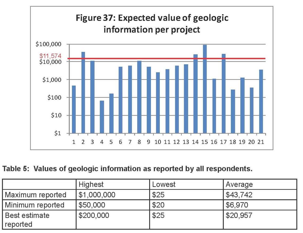
33

34
35
36 Economic Cost and Benefit Assessment Questionnaires
37
38

39
40
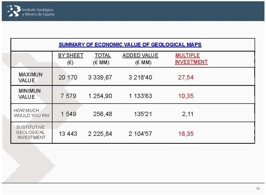
41 Cost and Benefit Conclusions Willingness to pay per map - $6,414 Total value of maps sold over 40 mos. - $13M Cost of mapping - $90,000 per 24K quad. Note - some faculty said 200K was cost for some maps. Cost:benefit ratio 1:147. Reasons for differences with IL and KY IL limited by 2 counties that are non mining and benefits were reduced considerably (regulatory efficiency). KY produces coal-a low value mineral. NV is earthquake prone and produces higher value minerals.
LIBRARY. ILLINOIS STATE GEOLOGICAL SURVEY III
 LIBRARY. IP ILLINOIS STATE GEOLOGICAL SURVEY III 3 3051 00006 9827 "*^ Benefits and Costs of Geologic Mapping Programs in Illinois The case of Boone and Winnebago Counties and its statewide applicability
KENTUCKY HAZARD MITIGATION PLAN RISK ASSESSMENT
 KENTUCKY HAZARD MITIGATION PLAN RISK ASSESSMENT Presentation Outline Development of the 2013 State Hazard Mitigation Plan Risk Assessment Determining risk assessment scale Census Data Aggregation Levels
What can I do with a major in Earth Information Science?
 Lewis-Clark State College offers a Bachelor of Arts or Science Degree in Earth Information Science through the Natural Sciences and Mathematics Division. You can learn more about the Natural Sciences and
They include earthquakes, volcanic eruptions, floods, landslides, and other processes and occurrences. They are included in the broader concept of.
 They include earthquakes, volcanic eruptions, floods, landslides, and other processes and occurrences. They are included in the broader concept of. In general, natural processes are labeled hazardous only
DEPARTMENT OF GEOLOGY AND MINERAL INDUSTRIES WAYS & MEANS SUBCOMMITTEE ON NATURAL RESOURCES MARCH 2, 2017
 DEPARTMENT OF GEOLOGY AND MINERAL INDUSTRIES WAYS & MEANS SUBCOMMITTEE ON NATURAL RESOURCES MARCH 2, 2017 1 ABOUT DOGAMI AGENCY MISSION, VISION & GOALS 2 Lidar image of a stream network along the Umpqua
CCR Surface Impoundment Location Restrictions Demonstration. MidAmerican Energy Company, Louisa Generating Station
 CCR Surface Impoundment Location Restrictions Demonstration MidAmerican Energy Company, Louisa Generating Station Final October 17, 2018 CCR Surface Impoundment Location Restrictions Demonstration Prepared
3/15/17. #22 - Subsidence - Rapid Sinkhole at Winter Park, FL in Rapid Subsidence Defined and Illustrated
 Web Exercise #3 (Volcanoes) Late- closing at 1:00 today Web Exercise #4 (Landslides) DUE WEDNESDAY Use Hazard City to answer matching question in Part II #22 - Subsidence - Rapid Sinkhole at Winter Park,
Geotechnical Risks and Management Systems: An FHWA Perspective
 October 13, 2010 2010 STGE Conference Charleston, WV Geotechnical Risks and Management Systems: An FHWA Perspective Silas C. Nichols, PE, Senior Bridge Engineer - Geotechnical Federal Highway Administration
INDIANAMAP VIEWING APPLICATION
 INDIANAMAP VIEWING APPLICATION (VERSION 1.0 ) Based on the 2005 Developed for the Indiana Department of Homeland Security by: IndianaMap Viewing Application Introduction The IndianaMap Viewing Application
Harvey Thorleifson, Director, Minnesota Geological Survey. Status of geological mapping needed for groundwater protection in Minnesota
 Harvey Thorleifson, Director, Minnesota Geological Survey Status of geological mapping needed for groundwater protection in Minnesota Minnesota is located between the Dakotas and Wisconsin, north of Iowa,
MEMORANDUM OF UNDERSTANDING. between the ASSOCIATION OF AMERICAN STATE GEOLOGISTS. and the U.S. DEPARTMENT OF THE INTERIOR OFFICE OF SURFACE MINING
 MEMORANDUM OF UNDERSTANDING between the ASSOCIATION OF AMERICAN STATE GEOLOGISTS and the U.S. DEPARTMENT OF THE INTERIOR OFFICE OF SURFACE MINING MEMORANDUM OF UNDERSTANDING between the ASSOCIATION OF
9. GEOLOGY, SOILS, AND MINERALS
 June 28, 2018 Page 9-1 9. GEOLOGY, SOILS, AND MINERALS This EIR chapter describes the existing geological, soil, and mineral conditions in the planning area. The chapter includes the regulatory framework
The Use of Geographic Information Systems (GIS) by Local Governments. Giving municipal decision-makers the power to make better decisions
 by Local Governments. Giving municipal decision-makers the power to make better decisions") The Use of Geographic Information Systems (GIS) by Local Governments Giving municipal decision-makers the power to make better decisions Case Study: Examples of GIS Usage by Local Governments in North
The Use of Geographic Information Systems (GIS) by Local Governments Giving municipal decision-makers the power to make better decisions Case Study: Examples of GIS Usage by Local Governments in North
The impact of the open geographical data follow up study Agency for Data Supply and Efficiency
 www.pwc.dk The impact of the open geographical data follow up study Agency for Data Supply and Efficiency March 17th 2017 Management summary In recent years, interest in releasing public-sector data has
Scout Name: Unit #: Date: GEOLOGY
 1) Explain what geology means. GEOLOGY Merit Badge Requirements Earth Materials 2) Make a collection of at least 10 different earth materials or geological specimens from your locality or an area of special
J.H. Campbell Generating Facility Pond A - Location Restriction Certification Report
 J.H. Campbell Generating Facility Pond A - Location Restriction Certification Report Pursuant to: 40 CFR 257.60 40 CFR 257.61 40 CFR 257.62 40 CFR 257.63 40 CFR 257.64 Submitted to: Consumers Energy Company
Landscape Analysis of Mineral Resources A View from Home Tree ( Avatar )
") NRC Workshop on Landscape Approaches and Multi-Resource Analysis for Sustainable Natural Resource Management: June 2, 2015 Landscape Analysis of Mineral Resources A View from Home Tree ( Avatar ) Murray
NRC Workshop on Landscape Approaches and Multi-Resource Analysis for Sustainable Natural Resource Management: June 2, 2015 Landscape Analysis of Mineral Resources A View from Home Tree ( Avatar ) Murray
Interpretive Map Series 24
 Oregon Department of Geology and Mineral Industries Interpretive Map Series 24 Geologic Hazards, and Hazard Maps, and Future Damage Estimates for Six Counties in the Mid/Southern Willamette Valley Including
WHAT IS MINERAL EXPLORATION?
 INDABA PRESENTATION CAPE TOWN FEBRUARY 2017 AIM:SAV WHAT IS MINERAL EXPLORATION? AIM:SAV What is mineral exploration? 2 Exploration is the term used to describe a wide range of activities aimed at searching
Geology and the Aggregate Industry: The Role of Geologists
 Geology and the Aggregate Industry: The Role of Geologists Donald G. Mikulic Illinois State Geological Survey Prairie Research Institute University of Illinois at Urbana-Champaign Outline Importance of
Association of Environmental & Engineering Geologists (AEG) To join AEG: Student membership is Free! Ask about our scholarships.
 To join AEG: Student membership is Free! Ask about our scholarships.") Association of Environmental & Engineering Geologists (AEG) To join AEG: www.aegweb.org/join Student membership is Free! Ask about our scholarships. What is the Association of Environmental & Engineering
Association of Environmental & Engineering Geologists (AEG) To join AEG: www.aegweb.org/join Student membership is Free! Ask about our scholarships. What is the Association of Environmental & Engineering
THE IMPACT OF LANDSLIDE AREAS ON MUNICIPAL SPATIAL PLANNING
 THE IMPACT OF LANDSLIDE AREAS ON MUNICIPAL SPATIAL PLANNING Jarosław Bydłosz, PhD Faculty of Mining Surveying and Environmental Engineering AGH University of Science and Technology e-mail: bydlosz@agh.edu.pl
THE POSSIBILITY OF INTEGRATING SUSTAINABILITY INTO LEGAL FRAMEWORK FOR USE OF OIL SHALE RESERVES
 Oil Shale, 2006, Vol. 23, No. 2 ISSN 0208-189X pp. 119 124 2006 Estonian Academy Publishers THE POSSIBILITY OF INTEGRATING SUSTAINABILITY INTO LEGAL FRAMEWORK FOR USE OF OIL SHALE RESERVES A. TEEDUMÄE
NEEA Refresh aka 3D Nation Requirements and Benefits Study. Allyson Jason, Carol Ostergren, Xan Fredericks and Lou Driber November 9, 2017
 + NEEA Refresh aka 3D Nation Requirements and Benefits Study Allyson Jason, Carol Ostergren, Xan Fredericks and Lou Driber November 9, 2017 + 2 Study Context Background The National Enhanced Elevation
Cost-Benefit Analysis of the Pooled- Fund Maintenance Decision Support System: Case Study
 Cost-Benefit Analysis of the Pooled- Fund Maintenance Decision Support System: Case Study Zhirui Ye (WTI) Xianming Shi (WTI) Christopher K. Strong (City of Oshkosh) 12 th AASHTO-TRB TRB Maintenance Management
CZECH REPUBLIC PROFILE with focus on the inventory of contaminated sites
 CZECH REPUBLIC PROFILE with focus on the inventory of contaminated sites Pavla Kacabova Ministry of the Environment of the Czech Republic Environmental Damages Department Kacabova_pavla@env.cz PRESENTATION
MUG Presentation. Quantifying Habitat Disturbance by Marcellus Shale Drilling Activities in Pennsylvania. Introduction. Previous Work.
 Quantifying Habitat Disturbance by Marcellus Shale Drilling Activities in Pennsylvania Dr. Chad Freed Elisabeth Powell Widener University MUG Presentation and Problem Statement GIS Data Acquisition and
APPLICATIONS OF EARTHQUAKE HAZARD MAPS TO LAND-USE AND EMERGENCY PLANNING EXAMPLES FROM THE PORTLAND AREA
 APPLICATIONS OF EARTHQUAKE HAZARD MAPS TO LAND-USE AND EMERGENCY PLANNING EXAMPLES FROM THE PORTLAND AREA O. Gerald Uba Metro, Portland, Oregon OVERVIEW The extent to which we understand "below ground"
Bringing Earth Science to Life
 Bringing Earth Science to Life Earth History Geomorphology Surface Processes Soils Rocks Minerals Tectonics Using Natural Resources Careers www.edgeo.org In partnership with: Students investigate the
Geology 101: Earth Processes and Environment
 1 Course Introduction 2 Geology 101: Earth Processes and Environment Syllabus & overview of topics The big challenges Why Geology Matters Dr. Steve Kuehn What is environmental geology? Major Earth systems
Layers (Layers in italics indicate group layers.) MyHazards MyPlan* Floods and Drought Landslides - USGS
 MyHazards MyPlan* Floods and Drought Landslides - USGS") MyHazards and MyPlan WebApps for Nevada Geohazards Over 100 hazard layers related to floods, fires, earthquakes, radon, and other supporting reference layers. Powerful educational and decision-making tools
MyHazards and MyPlan WebApps for Nevada Geohazards Over 100 hazard layers related to floods, fires, earthquakes, radon, and other supporting reference layers. Powerful educational and decision-making tools
Guidelines for Site-Specific Seismic Hazard Reports for Essential and Hazardous Facilities and Major and Special-Occupancy Structures in Oregon
 Guidelines for Site-Specific Seismic Hazard Reports for Essential and Hazardous Facilities and Major and Special-Occupancy Structures in Oregon By the Oregon Board of Geologist Examiners and the Oregon
Proposed Scope of Work Village of Farmingdale Downtown Farmingdale BOA Step 2 BOA Nomination Study / Draft Generic Environmental Impact Statement
 Proposed Scope of Work Village of Farmingdale Downtown Farmingdale BOA Step 2 BOA Nomination Study / Draft Generic Environmental Impact Statement The scope of work that follows incorporates and covers
MISSOURI LiDAR Stakeholders Meeting
 MISSOURI LiDAR Stakeholders Meeting East-West Gateway June 18, 2010 Tim Haithcoat Missouri GIO Enhanced Elevation Data What s different about it? Business requirements are changing.fast New data collection
EnviroAtlas: An Atlas about Ecosystems and their Connection with People
 EnviroAtlas: An Atlas about Ecosystems and their Connection with People Annie Neale, Megan Mehaffey & Atlas Team ASWM Webinar October, 17 th, 2012 What is it? The Atlas is an online decision support tool
CALENDAR YEAR 2017 BUDGET SOUTHEASTERN WISCONSIN REGIONAL PLANNING COMMISSION. P.O. Box 1607 W239 NI 812 Rockwood Drive Waukesha, Wisconsin
 CALENDAR YEAR 2017 BUDGET SOUTHEASTERN WISCONSIN REGIONAL PLANNING COMMISSION P.O. Box 1607 W239 NI 812 Rockwood Drive Waukesha, Wisconsin 53187-1607 Telephone: (262) 547-6721 Adopted by the Commission
COMMUNITY SERVICE AREA
 INSTITUTE FOR TRIBAL ENVIRONMENTAL PROFESSIONALS Tribal Waste and Response Assistance Program (TWRAP) Developing and Implementing a Tribal Integrated Solid Waste Management Plan April 12-14, 2016 Palm
Lakeland Court MHP Norton Rd Lakeland, FL 33809
 23-space/units - 2 Block Homes - 2 Duplexes 75% Occupied - Annual Leases - Long Term Tenants City Water - Septic Possible 3 additional spaces can be added Seller may consider offering Seller Financing
Taxes exclude taxes levied on consumption such as value added taxes, personal income taxes or sales taxes.
 Reports on Payments to Governments for the year ended 31 December 2017. Schlumberger Limited is providing the following disclosure pursuant to DTR 4.3A of the UK Financial Conduct Authority s Disclosure
Legal problems of environmental management. Spatial planning and space management. M. Gajewski 2014 / 2015
 Legal problems of environmental management Spatial planning and space management M. Gajewski 2014 / 2015 Course contents (in brief) Constitutional basis of the environment protection system. General principles
Sunshine City 47-Sp MHP
 Sunshine City 47-Sp MHP 47-sp MHP w/36 POM's Recreation Building used for StorageLaundry Room (Currently not in use) 70% Occupancy - 9-spaces left & 5 MH's left to lease 10 Mobile Homes Newly Rehabbed
GEOLOGY AND SOILS. This chapter summarizes geologic and geotechnical aspects of the site as they relate to the Project.
 9 GEOLOGY AND SOILS INTRODUCTION This chapter summarizes geologic and geotechnical aspects of the site as they relate to the Project. This chapter utilizes information from the following reports prepared
MANAGING TRANSPORTATION & LAND USE INTERACTIONS (PL-58)
") MANAGING TRANSPORTATION & LAND USE INTERACTIONS (PL-58) COURSE OUTLINE DAY ONE 1:30 2:00 p.m. MODULE 1: History and Context Understand history and foundation for transportation and land use planning today
MANAGING TRANSPORTATION & LAND USE INTERACTIONS (PL-58) COURSE OUTLINE DAY ONE 1:30 2:00 p.m. MODULE 1: History and Context Understand history and foundation for transportation and land use planning today
4.5 GEOLOGY, SOILS AND SEISMICITY
 4.5 This section summarizes information on geology, soils and seismic hazards, and mineral resources in the Truckee area, as well as potential area-wide geologic hazards and regional seismic characteristics
Economic Benefit Study on Value of Spatial Information Australian Experience
 Economic Benefit Study on Value of Spatial Information Australian Experience Dr Zaffar Sadiq Mohamed-Ghouse Director, International Relations Cooperative Research Centre for Spatial Information zsadiq@crcsi.com.au
BCGQ Mission Statement. Acquire new geoscientific knowledge in Québec within a sustainable development perspective of our mineral resources.
 BCGQ Mission Statement Acquire new geoscientific knowledge in Québec within a sustainable development perspective of our mineral resources. Financial Resources Natural Resources Fund, Mining Heritage Section
Vermont Geological Survey s Impact on Public Issues: Geologic Mapping Applied to Hazards and Water
 Vermont Geological Survey s Impact on Public Issues: Geologic Mapping Applied to Hazards and Water Presented by: Marjorie Gale, Vermont State Geologist 1 Jonathan Kim 1, George Springston 2, Colin Dowey
GUIDE TO THE SOUTH ISLAND AEROMAGNETIC SURVEYS
 GUIDE TO THE SOUTH ISLAND AEROMAGNETIC SURVEYS New Zealand has a long history of mining, but much of the country remains relatively underexplored and has real potential for further mineral discoveries.
Applied Geophysics for Environmental Site Characterization and Remediation
 Applied Geophysics for Environmental Site Characterization and Remediation MSECA Webinar September 24, 2015 John Mundell, P.E., L.P.G. Ryan Brumbaugh, L.P.G. MUNDELL & ASSOCIATES, INC. Webinar Objective
Why do we need measurements?
 CIVL 1101 Surveying - Introduction 1/5 Why do we need measurements? In science, measurement is the process of estimating or determining the magnitude of a quantity, such as length or mass, relative to
about GCC
 about GCC Bldg 234, Flat 11, Al Barakat Street, Hail Al Janaubiyah P.O Box: 94, Postal Code: 123, Al Khaudh, Sultante of Oman Fax : +968 24543188 Mobile :+968 96666445 info@gcc-oman.com www.gcc-oman.com
DOWNLOAD OR READ : UNITED STATES GEOLOGICAL SURVEY PROFESSIONAL PAPER PDF EBOOK EPUB MOBI
 DOWNLOAD OR READ : UNITED STATES GEOLOGICAL SURVEY PROFESSIONAL PAPER PDF EBOOK EPUB MOBI Page 1 Page 2 united states geological survey professional paper united states geological survey pdf united states
Environmental Geology
 GEO106 Environmental Geology SF movie Have your clicker ready 1906: San Francisco on fire 1906: San Francisco: a destroyed city 1 1994: Northridge earthquake December 26 th, 2003 Bam earthquake, Iran magnitude
Abstract: Contents. Literature review. 2 Methodology.. 2 Applications, results and discussion.. 2 Conclusions 12. Introduction
 Abstract: Landfill is one of the primary methods for municipal solid waste disposal. In order to reduce the environmental damage and to protect the public health and welfare, choosing the site for landfill
Energy and U.S. Consumers
 Energy and U.S. Consumers June 3, 2014 Sheril Kirshenbaum Director of The Energy Poll Impartial and authoritative source of public perspectives on energy to inform and guide discussion, business planning
2012 AND ESTIMATE FOR Q1, 2013 GROSS DOMESTIC PRODUCT FOR NIGERIA
 FEDERAL REPUBLIC OF NIGERIA (THE PRESIDENCY) 2012 AND ESTIMATE FOR Q1, 2013 GROSS DOMESTIC PRODUCT FOR NIGERIA National Bureau of Statistics Plot 762, Independence Avenue, Central Business District, Abuja
Brief History of Longwall Coal Mining in Illinois By Robert A. Bauer, Illinois State Geological Survey (7-2015)
") Brief History of Longwall Coal Mining in Illinois By Robert A. Bauer, Illinois State Geological Survey (7-2015) Introduction The first longwall coal mining started in the late 1600s in Great Britain and
Brief History of Longwall Coal Mining in Illinois By Robert A. Bauer, Illinois State Geological Survey (7-2015) Introduction The first longwall coal mining started in the late 1600s in Great Britain and
RETA 6422: Mainstreaming Environment for Poverty Reduction Category 2 Subproject
 RETA 6422: Mainstreaming Environment for Poverty Reduction Category 2 Subproject A. Basic Data 1. Subproject Title: Poverty-Environment Mapping to Support Decision Making 2. Country Director: Adrian Ruthenberg
Resiliency Assessed by Comparing Scenarios
 Resiliency Assessed by Comparing Scenarios Robert A. Bauer Illinois State Geological Survey Use HAZUS to estimate losses from nearby strong events vs. NLE-11 New Madrid Catastrophic M7.7 and NLE-11 Mt.
GIS Monroe Geographic Information System March 14, 2018
 GIS Monroe Geographic Information System March 14, 2018 Goals Maintain Enterprise/County-wide geo-database Increase spatial accuracy of data Build and acquire more data layers Increase use of GIS; as another
Section 2. Indiana Geographic Information Council: Strategic Plan
 Section 2. Indiana Geographic Information Council: Strategic Plan Introduction A geographic information system (GIS) is an automated tool that allows the collection, modification, storage, analysis, and
Comparing the MICROLAB 600 to Volumetric Glassware and Air Displacement Pipettes. June 2011
 Comparing the MICROLAB 600 to tric Glassware and Air Displacement Pipettes June 2011 tric Glassware and Air Displacement Pipettes Table of Contents ``Abstract...3 ``Introduction...4 ``Method & Results...5
Interpretive Map Series 24
 Oregon Department of Geology and Mineral Industries Interpretive Map Series 24 Geologic Hazards, Earthquake and Landslide Hazard Maps, and Future Earthquake Damage Estimates for Six Counties in the Mid/Southern
DIRECTORY OF COAL MINES IN ILLINOIS
 DIRECTORY OF COAL MINES IN ILLINOIS Champaign County This directory accompanies the Illinois Coal Mines map or maps for this County. August 2018 Prairie Research Institute Illinois State Geological Survey
MANAGEMENT OF SPATIAL DATA IN MULTIDISCIPLINARY PROJECTS
 MANAGEMENT OF SPATIAL DATA IN MULTIDISCIPLINARY PROJECTS Ir. B.P.J. van den Bergh Resource Analysis Dr. Ir. A. de Vries IWACO BV Working Group IC-19, TC IV-3, WG IV/6 KEY WORDS: Spatial Data Management,
Tellus Border Project Overview. Marie Cowan Ph.D Project Manager
 Tellus Border Project Overview Marie Cowan Ph.D Project Manager Presentation Outline History Goals Partners Project summary Legislative Framework Data Impacts Tellus History Proposed by GSNI, GSI, and
The Governance of Land Use
 The planning system The Governance of Land Use United Kingdom Levels of government and their responsibilities The United Kingdom is a unitary state with three devolved governments in Northern Ireland,
Comparing the Microlab 600 to Volumetric Glassware and Air Displacement Pipettes. January 2013
 Comparing the Microlab 600 to tric Glassware and Air Displacement Pipettes January 2013 White Paper: Comparing the Microlab 600 to tric Table of Contents Abstract... 3 Introduction... 4 Methods & Results...
Drilling & Developing the Marcellus Shale
 Drilling & Developing the Marcellus Shale Presented by the Independent Oil and Gas Association of Pennsylvania at the Pennsylvania State Association of Township Supervisors Annual Meeting, May 12, 2008,
PAHs in Parking Lot Sealcoats. Performance Study. Asphalt Based. Coal Tar Sealcoat Sealcoat. Sealcoat. Scrapings. Asphalt Based.
 PAHs in Parking Lot s Sitelab Corporation Visit: site-lab.com USA: 978-363-99 Performance Study PAHs in Parking Lot s Page 1 of 5 There is growing concern over the use of sealcoating products used on driveways,
Roadmap to Stability
 Landslide Policy Committee for Aizawl City February 2014 Technical Support by: Aizawl is in earthquake hazard zone V and highly prone to natural, man-made and earthquake induced landslides. In order to
HORIZON 2030: Land Use & Transportation November 2005
 PROJECTS Land Use An important component of the Horizon transportation planning process involved reviewing the area s comprehensive land use plans to ensure consistency between them and the longrange transportation
GEOGRAPHY OF THE UNITED STATES & CANADA. By Brett Lucas
 GEOGRAPHY OF THE UNITED STATES & CANADA By Brett Lucas THE APPALACHIANS & THE OZARKS Setting the Boundaries What states and provinces are part of the region? Eastern TN, western NC, eastern KY, western
Valuation of environmental amenities in urban land price: A case study in the Ulaanbaatar city, Mongolia
 1989 1990 1991 1992 1993 1994 1995 1996 1997 1998 1999 2000 2001 2002 2003 2004 2005 2006 2007 2008 2009 2010 2011 Population Valuation of environmental amenities in urban land price: A case study in the
Grassy Mountain Project Malheur County, Oregon: A Summary
 Oregon Department of Geology and Mineral Industries Grassy Mountain Project Malheur County, Oregon: A Summary Bob Houston, RG Hydrocarbon & Metallic Ore Geologist Grassy Mountain 0 Calico, 2017 1 Sherry
Contents. Ipswich City Council Ipswich Adopted Infrastructure Charges Resolution (No. 1) Page
 Page") Ipswich City Council Ipswich Adopted Infrastructure Charges Resolution (No. 1) 2014 Contents Page Part 1 Introduction 3 1. Short title 3 2. Commencement 3 3. Sustainable Planning Act 2009 3 4. Purpose
Ipswich City Council Ipswich Adopted Infrastructure Charges Resolution (No. 1) 2014 Contents Page Part 1 Introduction 3 1. Short title 3 2. Commencement 3 3. Sustainable Planning Act 2009 3 4. Purpose
3.11 Floodplains Existing Conditions
 Other stormwater control practices may be needed to mitigate water quality impacts. In addition to detention facilities, other practices such as vegetated basins/buffers, infiltration basins, and bioswales
VILLAGE OF ORLAND PARK
 14700 Ravinia Avenue Orland Park, IL 60462 www.orland-park.il.us Ordinance No: File Number: 2013-0373 AN ORDINANCE ESTABLISHING SPECIAL SERVICE AREA NUMBER 3 STATE OF ILLINOIS, COUNTIES OF COOK AND WILL
Chapter X: Radiation Safety Audit Program
 Chapter X: Radiation Safety Audit Program Policy All laboratories using radioactive material shall be reviewed as required by the Illinois Emergency Management Agency (IEMA), Division of Nuclear Safety
Green Chemistry Guide as an Effective Tool in Pollution Prevention
 Green Chemistry Guide as an Effective Tool in Pollution Prevention OLGA KREL - ASSOCIATE ENGINEER CITY OF LOS ANGELES DEPARTMENT OF PUBLIC WORKS BUREAU OF SANITATION INDUSTRIAL WASTE MANAGEMENT DIVISION
BUILDING STRUCTURES ON OR NEAR STEEP SLOPES
 BUILDING STRUCTURES ON OR NEAR STEEP SLOPES Benefits of Building Structures on or Near Steep Slopes Why would you ever do this? In some instances, it is the steep slope that people want to be near. Like
Zambia - Mining and Environmental Remediation and Improvement Project (P154683)
") AFRICA Zambia Environment & Natural Resources Global Practice IBRD/IDA Investment Project Financing FY 2017 Seq No: 4 ARCHIVED on 26-Nov-2018 ISR34605 Implementing Agencies: Ministry of Mines and Mineral
AFRICA Zambia Environment & Natural Resources Global Practice IBRD/IDA Investment Project Financing FY 2017 Seq No: 4 ARCHIVED on 26-Nov-2018 ISR34605 Implementing Agencies: Ministry of Mines and Mineral
The Richter Scale. Micro Less than 2.0 Microearthquakes, not felt. About 8,000/day
 Geologic Hazards General s are very rare in Pennsylvania and have caused very little damage and no reported injuries or casualties. Since the Commonwealth is not on an active fault, the earthquakes that
John Laznik 273 Delaplane Ave Newark, DE (302)
") Office Address: John Laznik 273 Delaplane Ave Newark, DE 19711 (302) 831-0479 Center for Applied Demography and Survey Research College of Human Services, Education and Public Policy University of Delaware
Office Address: John Laznik 273 Delaplane Ave Newark, DE 19711 (302) 831-0479 Center for Applied Demography and Survey Research College of Human Services, Education and Public Policy University of Delaware
1/20/2013. Introduction to Environmental Geology, 5e. Case History: Island of Hispaniola. Earth History. Earth s Place in Space
 Introduction to Environmental Geology, 5e Edward A. Keller Chapter 1 Philosophy and Fundamental Concepts Intro to Geology: summary haiku Here's geology. It's the study of the Earth - complete entity. Lecture
GOAL 7 AREAS SUBJECT TO NATURAL DISASTERS AND HAZARDS. To protect life and property from natural disasters and hazards.
 GOAL 7 AREAS SUBJECT TO NATURAL DISASTERS AND HAZARDS A. GOALS: To protect life and property from natural disasters and hazards. B. POLICIES: 1. Floodplains shall be maintained as natural drainage-ways.
NEW YORK AND CONNECTICUT SUSTAINABLE COMMUNITIES. Fair Housing & Equity Assessment & Regional Planning Enhancement
 NEW YORK AND CONNECTICUT SUSTAINABLE COMMUNITIES Fair Housing & Equity Assessment & Regional Planning Enhancement November 19, 2013 White Plains Public Library Federal grant to improve regional planning
THURSTON COUNTY COMPREHENSIVE PLAN UPDATE
 THURSTON COUNTY COMPREHENSIVE PLAN UPDATE BOARD OF COUNTY COMMISSIONERS WORK SESSION JUNE 14, 2017 Land Use Natural Resources Transportation Housing Utilities Environment Economic Development Capital Facilities
CARTER METALLURGICAL COAL PROJECT. Endurance Gold Corporation (EDG)
") CARTER METALLURGICAL COAL PROJECT McDOWELL COUNTY, WEST VIRGINIA Endurance Gold Corporation (EDG) Endurance Resources Inc. (ERI) Prepared by: Duncan McIvor, President and CEO Endurance Gold Corporation
CARTER METALLURGICAL COAL PROJECT McDOWELL COUNTY, WEST VIRGINIA Endurance Gold Corporation (EDG) Endurance Resources Inc. (ERI) Prepared by: Duncan McIvor, President and CEO Endurance Gold Corporation
1978 MSc Geology, South Dakota School of Mines and Technology Introduction to Groundwater Vistas (Groundwater Modeling) Albuquerque, New Mexico
 Albuquerque, New Mexico") Clyde Yancey, BSc, MSc, PGeo Vice President of Exploration Education 1978 MSc Geology, South Dakota School of Mines and Technology 1975 BA Geology Trinity University 1999 Introduction to Groundwater Vistas
Clyde Yancey, BSc, MSc, PGeo Vice President of Exploration Education 1978 MSc Geology, South Dakota School of Mines and Technology 1975 BA Geology Trinity University 1999 Introduction to Groundwater Vistas
Rocks, Minerals, & Mining. (I ain t sayin she a golddigga)
") Rocks, Minerals, & Mining (I ain t sayin she a golddigga) The Rock Cycle! Rocks are made up of multiple minerals. Minerals are made up of multiple elements. Rocks and minerals recycle or change due to
Rocks, Minerals, & Mining (I ain t sayin she a golddigga) The Rock Cycle! Rocks are made up of multiple minerals. Minerals are made up of multiple elements. Rocks and minerals recycle or change due to
RESOURCE REPORTING THE FIRST STEP IN SUSTAINABLE MINING. Committee for Mineral Reserves International Reporting Standards
 RESOURCE REPORTING THE FIRST STEP IN SUSTAINABLE MINING 1 B Y J O H N C L I F F O R D ( D E P U T Y C H A I R M A N C R I R S C O ) A N D N I A L L W E A T H E R S T O N E ( C H A I R M A N C R I S C O
Background and History
 p1 Background and History What is the Indian Ocean Climate Initiative? The Indian Ocean Climate Initiative (IOCI) is a strategic program of research and information transfer to support government decision-making.
CRP 608 Winter 10 Class presentation February 04, Senior Research Associate Kirwan Institute for the Study of Race and Ethnicity
 CRP 608 Winter 10 Class presentation February 04, 2010 SAMIR GAMBHIR SAMIR GAMBHIR Senior Research Associate Kirwan Institute for the Study of Race and Ethnicity Background Kirwan Institute Our work Using
Geographic Information System Services. Strategic Plan FY
 Geographic Information System Services Strategic Plan FY 2011 2012 Drafted by: Gary Palmer, Assistant Town Manager Major Sections: History Mission, Vision, Values Strategic Issues Performance Measurement
Responding to Natural Hazards: The Effects of Disaster on Residential Location Decisions and Health Outcomes
 Responding to Natural Hazards: The Effects of Disaster on Residential Location Decisions and Health Outcomes James Price Department of Economics University of New Mexico April 6 th, 2012 1 Introduction
Initial Borehole Drilling in the Hornepayne and Manitouwadge Area
 MAY 2017 PRELIMINARY ASSESSMENT OF POTENTIAL SUITABILITY Initial Borehole Drilling in the Hornepayne and Manitouwadge Area In 2010, the Nuclear Waste Management Organization (NWMO) began technical and
Hach Method Total Organic Carbon in Finished Drinking Water by Catalyzed Ozone Hydroxyl Radical Oxidation Infrared Analysis
 Hach Method 1061 Total Organic Carbon in Finished Drinking Water by Catalyzed Ozone Hydroxyl Radical Oxidation Infrared Analysis Hach Company Method 1061 Revision 1. December 015 Organic Carbon in Finished
Green Chemistry Member Survey April 2014
 Green Chemistry Member Survey April 2014 www.greenchemistryandcommerce.org Summary In 2014, the Green Chemistry & Commerce Council surveyed its business members to gain a better understanding of their
REGIS RESOURCES LTD. McPhillamys Update Presentation May 2018
 1 REGIS RESOURCES LTD McPhillamys Update Presentation May 2018 INTRODUCTION 2 BACKGROUND Regis intends to develop a 7.0 Mtpa open pit gold mine at McPhillamys including the process facility and supporting