Puget Sound Shorelines. Announcements
|
|
|
- Charlene Parsons
- 5 years ago
- Views:
Transcription


1 Announcements Puget Sound Shorelines Wednesday discussion of Bates paper Bham Bay project: Updates, finals week schedules Last portion of the class: Environmental issues in Puget Sound Puget Sound shorelines: Effects of beach armoring 1

 where Dρu/Dt = ρu/ t + u ρu/ x + v ρu/ y + w ρu/ z Dρv/Dt = ρv/ t + u ρv/ x + v ρv/ y + w ρv/ z Dρw/Dt = ρw/ t + u ρw/ x + v ρw/ y + w ρw/ z (non-linear terms) Equation of Continuity: u/ x + v/ y +")
2 Factors contributing to sediment transport and erosion Waves Sediment sources As wave velocity slows with decreasing water depth, waves bend, or refract when traveling over complex bottoms Wave energy is highest at headlands Lowest in bays Quantifying wave characteristics Adding wave velocity to momentum equations Momentum equations: Force/vol Pressure Coriolis Gravity Friction Dρu/Dt = - p/ x + ρ2ωvsin(φ) + K x ( 2 ρu/ x ρu/ y ρu/ z 2 ) Dρv/Dt = - p/ y - ρ2ωusin(φ) + K y ( 2 ρv/ x ρv/ y ρv/ z 2 ) Dρw/Ddt = - p/ z - ρg + K z ( 2 ρw/ x ρw/ y ρw/ z 2 ) where Dρu/Dt = ρu/ t + u ρu/ x + v ρu/ y + w ρu/ z Dρv/Dt = ρv/ t + u ρv/ x + v ρv/ y + w ρv/ z Dρw/Dt = ρw/ t + u ρw/ x + v ρw/ y + w ρw/ z (non-linear terms) Equation of Continuity: u/ x + v/ y + w/ z = 0 Let u = û + u, where û is the average velocity and u is the periodic velocity due to waves Near bottom velocities peak when waves pass by 2

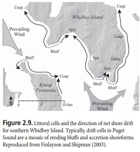
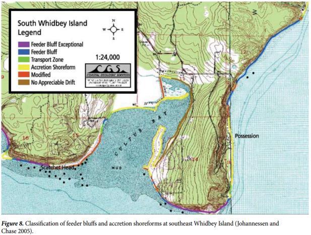
3 Factors controlling wave height Littoral drift cells 3


4 Shoreline types in Puget Sound Common types of shorelines in Puget Sound: Sand and gravel Sandy beach/dunes Sediment-starved beach Beach w/ bulkheads Mudflats Deltas Armoring of Puget Sound shorelines Shoreline development and armoring: 32% of historic intertidal wetlands lost 73% historic subaerial wetlands lost 30% of shorelines stabilized by structures 1.7 miles armored each year King County: ~ 80% of shorelines armored Requests to repair existing bulkheads require a Shoreline Substantial Development Permit Exemption (SSDPE) modified from Griggs, et al
 Sobocinski et al. Estuaries and Coasts, 2010 Invertebrates along the Duwamish River Estuary (Seattle).")

5 Effects of beach alteration on habitat characteristics and invertebrate densities in Puget Sound Wrack along Puget Sound beaches (Heerhartz et al. 2014) Sobocinski et al. Estuaries and Coasts, 2010 Invertebrates along the Duwamish River Estuary (Seattle). Morley et al Scales of change due to armoring Importance of nearshore zone High productivity Erosion control Water-quality control (nutrient cycling, bioreactivity) Wildlife habitat Habitat mosaic enhances biodiversity Natural resources Asthetics Dethier et al
 Sediment supply to Puget Sound beaches Most beaches")
6 Primary productivity biomass (g dry m-2) productivity (g dry m-2 yr-1) NEARSHORE ESTIMATED TOTAL ANNUAL NET PRODUCTION OF PRIMARY PRODUCERS IN HOOD CANAL brackish marsh macroalgae eelgrass & epiphytes benthic microalgae salt marsh phytoplankton From Simenstad 2004 (Simenstad and Wissmar 1985) Sediment supply to Puget Sound beaches Most beaches sediment starved > 80% of sediment delivered to the Sound by streamflow comes from the 3 rivers: the Skagit, the Puyallup, and the Snohomish. Deltas in protected embayments trap the sediment. Sediment in much of Puget Sound is delivered by coastline erosion and landslides Coarse-grained sediment remains. Fine-grained sand (important for seagrass beds) is more easily eroded. Critical erosion velocities often attained during wave passage Nearshore habitat usage Forage fish for salmon and rockfish: Pacific herring, surf smelt and Pacific sand lance Depend on nearshore marine habitats for spawning and rearing. WDFW enforces No Net Loss regulations for the protection of known forage fish spawning sites 6


 is")

7 Nearshore habitat usage Surf smelt spawning beaches Sand lance: spawn on sand beaches Surf Smelt: Spawn in upper intertidal zone on sand and gravel beaches at high tide Herring: Spawn in lower intertidal and upper subtidal regions of bays and sheltered beaches Longfin smelt (Spirinchus thaleichthys) is present but less common in Puget Sound Sand lance spawning beaches Herring spawning grounds 7


8 Shoreline factors affecting spawning success Riparian habitat: Shading, detritus and debris increase spawning success. Riparian vegetation affects nearshore sediment supply Freshwater seeps thought to help spawning Stormwater outfall pipes Bulkheads and seawalls: bury upper intertidal zone, reduce sedimentation, increase erosion, leading to beach armoring and reduced spawning habitat Forage fish spawning grounds in Bellingham Bay Surf smelt spawn in upper intertidal zone In Bellingham Bay, they spawn only in a few spots All other shorelines in the bay have bulkheads or seawalls Nearshore use by salmon species Surf smelt and sand lance spawning areas in Bellingham Bay (Williams and Thom 2001) 8


 NearPRISM")
9 Nearshore use by other fish species Eelgrass (Zostera marina) and Hood Canal chum salmon Migratory corridor Predation refuge Foraging habitat (Williams and Thom 2001) NearPRISM Puget Sound Shorelines 9
Nearshore Habitats Why What You do Matters. Landscapes on the Edge November 2016
 Nearshore Habitats Why What You do Matters Landscapes on the Edge November 2016 Primary Topics Focus on marine shorelines ESA species rely on this area Many other fish and wildlife rely on this area The
Introduction. Methods. Keyword: Bulkhead, Armoring, Thurston County, SRFB, Forage Fish
 Bulkheading in Thurston County: Impacts on Forage Fish Spawning Habitat José Carrasquero-Verde (jcarrasquero@herrerainc.com), Tim Abbe (tabbe@herrerainc.com), Herrera Environmental Consultants Steven Morrison
1 Shoreline Landforms 2. 2 Emergent v. Submergent 2. 3 Wavecutting 3. 4 Planview 4. 5 Marine Terraces 5. 6 California 7. 7 Tombolos, Sea Stacks 8
 Shorelines November 9, 2008 Contents 1 Shoreline Landforms 2 2 Emergent v. Submergent 2 3 Wavecutting 3 4 Planview 4 5 Marine Terraces 5 6 California 7 7 Tombolos, Sea Stacks 8 8 Active Processes 9 9 Emergence
2.11 STRAIT OF JUAN DE FUCA MARINE NEARSHORE ENVIRONMENT
 Chapter 2.11 Strait of Juan de Fuca Marine Nearshore Environment Page 2.11-1 2.11 STRAIT OF JUAN DE FUCA MARINE NEARSHORE ENVIRONMENT 2.11.1 Overview The coastline of the area covered by this watershed
ALTERNATIVES TO BULKHEADS IN THE PUGET SOUND REGION: WHAT IS SOFT SHORE PROTECTION? WHAT IS NOT? Jim Johannessen MS, Coastal Geologic Services, Inc.
 Coasts at the Millennium Proceedings of the 17th International Conference of The Coastal Society, Portland, OR USA ALTERNATIVES TO BULKHEADS IN THE PUGET SOUND REGION: WHAT IS SOFT SHORE PROTECTION? WHAT
Planning for the Future of Humboldt Bay: Sea Level Rise, Sediment Management, Sand Spits and Salt Marshes. Joel Gerwein
 Planning for the Future of Humboldt Bay: Sea Level Rise, Sediment Management, Sand Spits and Salt Marshes Joel Gerwein Introduction to Humboldt Bay Setting Economy, community, and environment Sediment
3. MARINE HABITAT RESTORATION
 Feasibility Study for Restoration of Titlow Lagoon Fish Passage South Puget Sound Salmon Enhancement Group 3. MARINE HABITAT RESTORATION Marine habitat restoration at Titlow Park could include restoration
-- Lessons from a successful salmon stream and estuary relocation on Gravina Island
 Re-inventing Government Creek -- Lessons from a successful salmon stream and estuary relocation on Gravina Island Jon Houghton, Ph.D. and Derek Ormerod, M.S., P.E. - Pentec Environmental/Hart Crowser,
Community Mapping Network. Selected Coastal Atlases and Information Systems in British Columbia, Canada
 Community Mapping Network Selected Coastal Atlases and Information Systems in British Columbia, Canada Outline Community Mapping Network cmnbc.ca Pacific Coastal Resources Atlas for BC cmnbc.ca The Living
3. STRAIT OF JUAN DE FUCA ECOSYSTEM: MARINE SHORELINES
 Clallam County SMP Update - Inventory and Characterization Report 0 0 0. STRAIT OF JUAN DE FUCA ECOSYSTEM: MARINE SHORELINES Clallam County marine shorelines are buffeted directly by wind and waves entering
Soft Shore Protection As An Alternative To Bulkheads - Projects And Monitoring
 Soft Shore Protection As An Alternative To Bulkheads - Projects And Monitoring Jim W. Johannessen Coastal Geologic Services, Inc. Introduction Beach erosion and improper development along the shore have
The Refugia Concept: Using Watershed Analysis to Prioritize Salmonid Habitat for Conservation and Restoration
 The Refugia Concept: Using Watershed Analysis to Prioritize Salmonid Habitat for Conservation and Restoration Christopher May Battelle & UW Cumulative Impacts of Urbanization Landscape Alterations Loss
Bob Van Dolah. Marine Resources Research Institute South Carolina Department of Natural Resources
 Bob Van Dolah Marine Resources Research Institute South Carolina Department of Natural Resources Shoreline Change Will Occur! On our front beaches where it is not easy to retreat Shoreline Change Will
Sea Level Rise Providing Nature A-Right-of Way
 Sea Level Rise Providing Nature A-Right-of Way Study Area Site 2: Skagit Bay Initial Condition 11.2 Inches by 2050 No Dikes 27.3 Inches by 2100 No Dikes The Problem Loss of coastal wetlands due to submergence
3. STRAIT OF JUAN DE FUCA ECOSYSTEM: MARINE SHORELINES
 Clallam County SMP Update - Inventory and Characterization Report 3. STRAIT OF JUAN DE FUCA ECOSYSTEM: MARINE SHORELINES Clallam County marine shorelines are buffeted directly by wind and waves entering
Modeling habitat suitability for the European green crab using the ShoreZone mapping system
 Modeling habitat suitability for the European green crab using the ShoreZone mapping system Jodi N. Harney, Ph.D. and John R. Harper, Ph.D. Coastal and Ocean Resources Inc. Mary Morris, R.P. Bio. Archipelago
FORAGE FISH SPAWNING IN THE ELWHA NEARSHORE: ECOLOGICAL FORM AND FUNCTION IN A CHANGING ENVIRONMENT. Leif T. Wefferling
 FORAGE FISH SPAWNING IN THE ELWHA NEARSHORE: ECOLOGICAL FORM AND FUNCTION IN A CHANGING ENVIRONMENT by Leif T. Wefferling A Thesis Submitted in partial fulfillment of the requirements for the degree Master
Relatively little hard substrate occurs naturally in the
 CHAPTER FIVE Rock Habitats Relatively little hard substrate occurs naturally in the estuary, owing mainly to the vast quantities of fine sediment that have been deposited by the rivers. Rock habitat is
COMPARING OFF-BOTTOM OYSTER CULTURE AND EELGRASS (Z. MARINA) BEDS USING A HABITAT SUITABILITY INDEX
 BEDS USING A HABITAT SUITABILITY INDEX") COMPARING OFF-BOTTOM OYSTER CULTURE AND EELGRASS (Z. MARINA) BEDS USING A HABITAT SUITABILITY INDEX P R O J E C T T E A M L E A D S : B O B B I H U D S O N, P A C I F I C S H E L L F I S H I N S T I T
COMPARING OFF-BOTTOM OYSTER CULTURE AND EELGRASS (Z. MARINA) BEDS USING A HABITAT SUITABILITY INDEX P R O J E C T T E A M L E A D S : B O B B I H U D S O N, P A C I F I C S H E L L F I S H I N S T I T
PROBABILITY-BASED ESTIMATION OF NEARSHORE HABITAT CHARACTERISTICS
 In: Proceedings of Puget Research '98 Conference, Seattle, WA. PROBABILITY-BASED ESTIMATION OF NEARSHORE HABITAT CHARACTERISTICS Allison Bailey, Helen Berry, Betty Bookheim Washington State Department
Armoring on Puget Sound: Progress towards a better baseline
 Western Washington University Western CEDAR Salish Sea Ecosystem Conference 2016 Salish Sea Ecosystem Conference (Vancouver, BC) Armoring on Puget Sound: Progress towards a better baseline Hugh Shipman
The Coast: Beaches and Shoreline Processes
 1 2 3 4 5 6 7 8 9 The Coast: es and Shoreline Processes Trujillo & Thurman, Chapter 10 Oceanography 101 Chapter Objectives Recognize the various landforms characteristic of beaches and coastal regions.
Earth Science Lesson Plan Quarter 2, Week 10, Day 1
 Earth Science Lesson Plan Quarter 2, Week 10, Day 1 Outcomes for Today Standard Focus: PREPARE 1. Background knowledge necessary for today s reading. Beaches are created by the actions of waves, tides,
The Coast: Beaches and Shoreline Processes Trujillo & Thurman, Chapter 10
 The Coast: es and Shoreline Processes Trujillo & Thurman, Chapter 10 Oceanography 101 Chapter Objectives Recognize the various landforms characteristic of beaches and coastal regions. Identify seasonal
Sediment Management in the Coastal Bays
 Sediment Management in the Coastal Bays Introduction Need for ecosystem view of sediment management in Coastal Bays Island loss and restoration Navigation needs Habitat Trade offs Living Shoreline Requirements
Coastal issues: Beaches and Estuaries
 Coastal issues: Beaches and Estuaries Definitions: Coast = broad zone where both marine & terrestrial processes act It includes the beach, lagoons, marshes, bars etc. Coastal processes act to shape the
Presentation Outline. Project Overview. Sea Level Rise Assessment & Decision Tools. Community Engagement. Tina Whitman, Friends of the San Juans
 Healthy Beaches for People & Fish Sea Level Rise Adaptation Tools for San Juan County, WA Tina Whitman & Andrea MacLennan December 10, 2015 Presentation Outline Project Overview Tina Whitman, Friends of
Connecticut Coastal Management Program
 Connecticut Coastal Management Program Fact Sheet for SHORELINE FLOOD AND EROSION CONTROL STRUCTURES What are Shoreline Flood and Erosion Control Structures? The Connecticut General Statutes (CGS) define
Supplemental Slides. Shore: Junction of Land & Water. Junction of Land & Water. Sea Level Variations. Shore vs. Coast. Sea Level Variations
 Shore: Junction of Land & Water Supplemental Slides Sediments come off land Most get dumped at the beach Sediment interacts with ocean waves and currents Junction of Land & Water Features: Breaking waves,
Shore: Junction of Land & Water. Sediments come off land Most get dumped at the beach Sediment interacts with ocean waves and currents
 Shore: Junction of Land & Water Supplemental Slides Sediments come off land Most get dumped at the beach Sediment interacts with ocean waves and currents Junction of Land & Water Features: Breaking waves,
Island Design. UMRS EMP Regional Workshop. Presentation for the
 Island Design Presentation for the UMRS EMP Regional Workshop by Jon Hendrickson Hydraulic Engineer Regional Technical Specialist, Water Quality and Habitat Restoration August 17 19, 2005 Project Delivery
We are interconnected, we are resilient As air temperatures warm forests change, fires increase glaciers retreat, snowpack diminishes sediment
 We are interconnected, we are resilient As air temperatures warm forests change, fires increase glaciers retreat, snowpack diminishes sediment increases rivers change, salmon respond base sea level rises
6. Geomorphology. Abstract
 6. Geomorphology Abstract The Skagit River delta has evolved over time due to both human and natural processes. Human activities such as construction of dikes and levees have influenced the spatial location,
FEASIBILITY ASSESSMENT FOR SALT MARSH RESTORATION AT CAMANO ISLAND STATE PARK, WHIDBEY BASIN
 FEASIBILITY ASSESSMENT FOR SALT MARSH RESTORATION AT CAMANO ISLAND STATE PARK, WHIDBEY BASIN Aundrea McBride and Eric Beamer Skagit River System Cooperative August 2010 Photo from Washington State Department
July Submitted to Point No Point Treaty Council. Submitted by
 Assessment of Estuarine and Nearshore Habitats for Threatened Salmon Stocks in the Hood Canal and Eastern Strait of Juan de Fuca, Washington State: Focal Areas 1-4 July 2002 Submitted to Point No Point
Living Shorelines: The origins of a practice, the sudden rise of interest within the stormwater community, and the debate
 Living Shorelines: The origins of a practice, the sudden rise of interest within the stormwater community, and the debate Jana Davis Chesapeake Bay Trust Definition of Living Shorelines "Living shorelines"
Dam Removal Analysis Guidelines for Sediment
 A review of: Dam Removal Analysis Guidelines for Sediment Joe Rathbun (Retired) rathbunj@sbcglobal.net Some Potential Sediment Issues Reservoir restoration Downstream water quality Downstream deposition
Aundrea McBride, Karen Wolf, and Eric Beamer June 2006
 SKAGIT BAY NEARSHORE HABITAT MAPPING Aundrea McBride, Karen Wolf, and Eric Beamer June 2006 INTRODUCTION Juvenile Chinook salmon travel through and utilize nearshore habitats as part of their life cycle.
Lower South Fork McKenzie River Floodplain Enhancement Project
 Lower South Fork McKenzie River Floodplain Enhancement Project McKenzie River Ranger District Willamette National Forest Project Location The project is located in the South Fork McKenzie River Watershed,
Generalized Conceptual Models Wetlands Regional Monitoring Program Compiled for the PEEIR
 1 Generalized Conceptual Models Wetlands Regional Monitoring Program 2002 Compiled for the PEEIR 2 1. MANAGEMENT QUESTIONS DRIVE INDICATOR DEVELOPMENT The overarching wetland management questions are:
Geol 117 Lecture 18 Beaches & Coastlines. I. Types of Coastlines A. Definition:
 I. Types of Coastlines A. Definition: 1. Shore = narrow zone where ocean meets land (e.g. beach) 2. Coast is a broad area where both ocean and land processes act a. Includes onshore marshes, dunes, sea
Developing a Geomorphic Model for Nearshore Habitat Mapping and Analysis
 Developing a Geomorphic Model for Nearshore Habitat Mapping and Analysis October 6, 2009 Aundrea McBride 1, Steve Todd 2, Osa Odum 3, Marilu Koschak 3, and Eric Beamer 1 1 Skagit River System Cooperative,
Coastal Processes 101. Greg Berman (Woods Hole Sea Grant & Cape Cod Cooperative Extension)
") Coastal Processes 101 Greg Berman (Woods Hole Sea Grant & Cape Cod Cooperative Extension) January 23, 2019 Coastal Processes 101 Outline: ~30 min talk Coastal Processes What is Erosion? Value of the Ecosystem
Coastal Processes 101 Greg Berman (Woods Hole Sea Grant & Cape Cod Cooperative Extension) January 23, 2019 Coastal Processes 101 Outline: ~30 min talk Coastal Processes What is Erosion? Value of the Ecosystem
Setting Priorities for Eelgrass Conservation and Restoration. Robert Buchsbaum Massachusetts Audubon Society
 Setting Priorities for Eelgrass Conservation and Restoration Robert Buchsbaum Massachusetts Audubon Society Eelgrass habitat values A rich, productive habitat for many marine organisms Nursery habitat
COASTAL GEOLOGIC SERVICES, INC.
 COASTAL GEOLOGIC SERVICES, INC. Pocket Beach Mapping in San Juan County Prepared for: Friends of the San Juan Prepared by: Andrea MacLennan, MS and Stephanie Williams BS/BA Coastal Geologic Services, Inc.
ICAN Great Lakes Workshop
 Washington Coastal latlas ICAN Great Lakes Workshop September 13 15, 15 2010 Current Washington Coastal Atlas http://www.ecy.wa.gov/programs/sea/sma/atlas_home.html 1 st version of WA Coastal Atlas was
Aim and objectives Components of vulnerability National Coastal Vulnerability Assessment 2
 ASSESSING THE UTILITY OF GEOMORPHIC SENSITIVITY MAPPING ON THE ILLAWARRA COAST Pamela Abuodha, Christina Baker, Chris Sharples, Darren Skene and Colin Woodroffe Geoquest Research Centre, University of
Virginia Shoreline Mapping Tools
 Virginia Shoreline Mapping Tools December 15, 2017 Karen Duhring Center for Coastal Resources Management Virginia Institute of Marine Science College of William & Mary Virginia Shoreline Mapping Tools
Draft Technical Memorandum
 5309 Shilshole Avenue NW Suite 200 Seattle, WA 98107 206.789.9658 phone 206.789.9684 fax www.esassoc.com Draft Technical Memorandum date February 21, 2013 to from subject Renee LaCroix, City of Bellingham
Gespe gewaq Mi gmaq. Resource Council. Coastal Erosion Awareness. Ugpi ganjig Sitmug Eel River Bar Beach
 Gespe gewaq Mi gmaq Resource Council Coastal Erosion Awareness Ugpi ganjig Sitmug Eel River Bar Beach 2 Table of Contents Introduction...1 Driving Force 1:...2 Sensitivity to Sea-Level Rise Driving Force
Soft Shore Protection/Structure Removal Blueprint for San Juan County Forage Fish Beaches
 Soft Shore Protection/Structure Removal Blueprint for San Juan County Forage Fish Beaches Prepared for: Friends of the San Juans Prepared by: Jim Johannessen, MS, LEG and Andrea MacLennan, MS 701 Wilson
Sunset Harbour / Huntington Harbour Maintenance Dredging and Waterline Installation Project. CMANC 21 January 2016
 Sunset Harbour / Huntington Harbour Maintenance Dredging and Waterline Installation Project CMANC 21 January 2016 County of Orange Footprint Huntington Harbour Operational and Dredging Cost Sharing Agreements
Shoreline and Climate Change Adaptation Alternatives for The Letter Parcel, Bolinas Lagoon
 Shoreline and Climate Change Adaptation Alternatives for The Letter Parcel, Bolinas Lagoon Scenic shoreline vista of Bolinas Lagoon and ridges, from Letter Parcel, March 2016 Peter Baye, Coastal Ecologist
Marine biodiversity - PBBT102
 Marine biodiversity - PBBT102 UNIT 1 (2 marks) 1. Define marine biodiversity? 2. How biodiversity is measured? 3. Why many species go extinct every day? 4. What is biodiversity hotspot? 5. What are endemic
Heather Schlosser Army Corps of Engineers Coastal Studies Group August 28, 2008
 Got sand? Regional Sediment Management in Orange County Heather Schlosser Army Corps of Engineers Coastal Studies Group August 28, 2008 Regional Sediment Management Regional sediment management recognizes
Coastal Vulnerability and Risk Parameters
 European Water 11/12: 3-7, 2005. 2005 E.W. Publications Coastal Vulnerability and Risk Parameters E. Doukakis National Technical University of Athens-Dept. of Rural and Surveying Engineering, Lab. of Higher
ssessments Ecoregional Assessment
 Standard 7: Select terrestrial, freshwater and marine conservation targets/biodiversity elements/features across multiple biological and spatial scales. Case Study: Shoreline Habitat Classification for
Significant Ecological Marine Area Assessment Sheet
 Significant Ecological arine Area Assessment Sheet Name: Eastern Bay of Island Biogenic Soft Sediment Complex Summary: The semi-sheltered areas between the central islands of the Eastern Bay of Islands
DELIVERABLES FOR TASK NO: 4 Shannon Point Riprap Removal Feasibility Study and 60% Project Design
 County: Skagit County Grant No: G1400105 PROJECT TITLE: Northwest Straits Project: Skagit County Marine Resources Committee Operations and Projects DELIVERABLES FOR TASK NO: 4 Shannon Point Riprap Removal
Spatial variation in the abundance of eelgrass (Zostera marina) at eight sites in western Newfoundland, Canada 5/5/2015 V2.0
 at eight sites in western Newfoundland, Canada 5/5/2015 V2.0") Spatial variation in the abundance of eelgrass (Zostera marina) at eight sites in western Newfoundland, Canada 5/5/2015 V2.0 1 Summary The abundance of eelgrass (Zostera marina) was quantified at eight
Spatial variation in the abundance of eelgrass (Zostera marina) at eight sites in western Newfoundland, Canada 5/5/2015 V2.0 1 Summary The abundance of eelgrass (Zostera marina) was quantified at eight
PCB Aroclor Concentrations in Puget Sound Sediments
 PCB Aroclor Concentrations in Puget Sound Sediments Margaret Dutch, Sandra Aasen and Edward R. Long Washington State Department of Ecology Environmental Assessment Program [Editor s note: Tables and Figures
Coastal Processes 101 & The Regs. Greg Berman (Woods Hole Sea Grant & Cape Cod Cooperative Extension)
") Coastal Processes 101 & The Regs Greg Berman (Woods Hole Sea Grant & Cape Cod Cooperative Extension) March 26, 2019 Coastal Processes 101 & The Regs Outline: ~15 min talk Coastal Processes What is Erosion?
Coastal Processes 101 & The Regs Greg Berman (Woods Hole Sea Grant & Cape Cod Cooperative Extension) March 26, 2019 Coastal Processes 101 & The Regs Outline: ~15 min talk Coastal Processes What is Erosion?
Mapping of Future Coastal Hazards. for Southern California. January 7th, David Revell, Ph.D. E.
 Mapping of Future Coastal Hazards for Southern California January 7th, 2014 David Revell, Ph.D. drevell@esassoc.com E. Vandebroek, 2012 Outline Coastal erosion hazard zones Flood hazard zones: Coastal
THE EFFECTS OF LIGHT ON EELGRASS (ZOSTERA MARINA) GROWTH RATES IN SEQUIM BAY. Allie Simpson
 GROWTH RATES IN SEQUIM BAY. Allie Simpson") THE EFFECTS OF LIGHT ON EELGRASS (ZOSTERA MARINA) GROWTH RATES IN SEQUIM BAY Allie Simpson Abstract Seagrasses form meadows that provide many ecological services ranging from supplying food and habitat
THE EFFECTS OF LIGHT ON EELGRASS (ZOSTERA MARINA) GROWTH RATES IN SEQUIM BAY Allie Simpson Abstract Seagrasses form meadows that provide many ecological services ranging from supplying food and habitat
Grain size on the Elwha River delta intertidal beach: impacts of dam removal and implications for Pacific sand lance (Ammodytes hexapterus)
") Grain size on the Elwha River delta intertidal beach: impacts of dam removal and implications for Pacific sand lance (Ammodytes hexapterus) Carol M. Holman 1 Marine Sedimentary Processes Research Apprenticeship
Grain size on the Elwha River delta intertidal beach: impacts of dam removal and implications for Pacific sand lance (Ammodytes hexapterus) Carol M. Holman 1 Marine Sedimentary Processes Research Apprenticeship
Sea Level Rise in Miami-Dade County Florida Implications for Management of Coastal Wetlands and the Everglades
 Sea Level Rise in Miami-Dade County Florida Implications for Management of Coastal Wetlands and the Everglades Peter W. Harlem Dr. John F. Meeder Florida International University Southeast Environmental
Fluvial Driven Alluvial Fans
 Fluvial Driven Alluvial Fans Restoration Project Evaluations - Examples from the Russian and Napa River Watersheds Mia Docto Masters Thesis UC Berkeley 1. Basic Fan Description 2. Fluvial Driven Fan Characteristics
Swan Lake Restoration Preliminary Feasibility Study Final Report
 Swan Lake Restoration Preliminary Feasibility Study Final Report Prepared for: Skagit Fisheries Enhancement Group Swan Lake Watershed Preservation Group By: Jim Johannessen, Licensed Engineering Geologist,
Bolinas Lagoon Ecosystem Restoration Feasibility Project. Final Public Reports. Projecting the Future of Bolinas Lagoon
 Bolinas Lagoon Ecosystem Restoration Feasibility Project Final Public Reports II Projecting the Future of Bolinas Lagoon PROJECTING THE FUTURE EVOLUTION OF BOLINAS LAGOON Final Public Draft Prepared for
Ecosystem response during the removal of the Elwha River Dams
 Ecosystem response during the removal of the Elwha River Dams Presentation Prepared by George Pess - NOAA Photo by John McMillan December 2015 Elwha The Elwha River Basin Olympic Natl. Park > 90% of habitat
Primer on Coastal Erosion And Habitat Creation
 2 nd Regional Conference Dredging, Beach Nourishment & Bird Conservation Primer on Coastal Erosion And Habitat Creation Timothy Kana Ph.D Source: Newsday 1962 Photo by Kelsey Aerials 1978 Source: U Mass
Fish Passage at Road Crossings
 Fish Passage at Road Crossings 1 Crossing Design Workshop Outline 1:00 to 2:00 Intro, Design Overview, Channel Width 2:00 to 2:15 Break 2:15 to 3:15 No-Slope, Stream Simulation Design 3:15 to 3:30 Break
APPENDIX E-4. Field Report: Intertidal Habitat and Marine Biota Survey
 APPENDIX E-4 Field Report: Intertidal Habitat and Marine Biota Survey Field Report Intertidal Habitat and Marine Biota Survey of the Vallejo Marine Terminal Site, Vallejo, California April 18, 2014 Prepared
TIDAL EROSION AT ELKHORN SLOUGH
 TIDAL EROSION AT ELKHORN SLOUGH Virtually all of California s tidal wetlands have been dramatically altered. Hydrological manipulations changes in water flow are widespread. Either flow has been decreased
Elwha River response to dam removals through four years and a big flood:
 Elwha River response to dam removals through four years and a big flood: Lessons learned, channel response, and sediment effects from the world s largest engineered dam removal Andy Ritchie NPS Elwha Restoration
Dunes Growth Estimation for Coastal Protection
 Dunes Growth Estimation for Coastal Protection Muhammad Zikra Department of Ocean Engineering, Faculty of Marine Technology, ITS, Kampus ITS Keputih Sukolilo, Surabaya 60111 Abstract: This paper describes
Ms. A. Mormando's Class *
 8 th Grade Science Essential Standard: 8.E.1.1 Explain the structure of the hydrosphere including: Water distribution on Earth; Local river basin and water availability Stream - A stream is a body of water
The Geomorphology of Puget Sound Beaches
 Technical Report 2006-02 The Geomorphology of Puget Sound Beaches Prepared in support of the Puget Sound Nearshore Partnership (PSNP) October 2006 David Finlayson, University of Washington The Geomorphology
The Marine Environment
 The Marine Environment SECTION 16.1 Shoreline Features In your textbook, read about erosional landforms, beaches, estuaries, longshore currents, and rip currents. For each statement below, write or. 1.
Historic Characterization of WRIA 9 Shoreline Landforms
 Technical Report 2005-01 Historic Characterization of WRIA 9 Shoreline Landforms Prepared in support of the Puget Sound Nearshore Partnership November 2005 Jessemine Fung and Chris Davis CommEn Space Technical
In 1990, 50% of the U.S. population lived within 75 km of a coast. By 2010, 75% of the U.S. population will live within 75 km of a coast.
 In 1990, 50% of the U.S. population lived within 75 km of a coast. By 2010, 75% of the U.S. population will live within 75 km of a coast. High Tech Methods for Surveying the Deep Sea Floor Fig. 20.18 1
Photosynthetic Habitats
 6. Kelps, Mangroves & Photosynthetic Habitats Photosynthetic Habitats Kelps Anatomy Community Ecosystem Mangroves Anatomy Community Ecosystem Other photosynthetic habitats Seagrasses Dr Rhian G. Waller
COMPONENTS OF A COMPLETE EELGRASS DELINEATION REPORT
 COMPONENTS OF A COMPLETE EELGRASS DELINEATION REPORT CONTENTS January 9, 2018 Purpose... 1 Qualifications... 1 Timing... 1 Overview of Eelgrass Survey Types... 1 Preliminary Survey... 2 Defining and Delineating
Effects of Bulkheads on Estuarine Shores: an Example from Fire Island National Seashore, USA
 Journal of Coastal Research SI 56 188-192 ICS2009 (Proceedings) Portugal ISSN 0749-0258 Effects of Bulkheads on Estuarine Shores: an Example from Fire Island National Seashore, USA K.F. Nordstrom, N.L.
Create your own map for tidepooling, beach field trips, boating, camping, kayaking, fishing, and exploring the beaches in Southcentral Alaska.
 Create your own map for tidepooling, beach field trips, boating, camping, kayaking, fishing, and exploring the beaches in Southcentral Alaska. Here s an opportunity to download and customize your own free
SHORELINE AND BEACH PROCESSES: PART 2. Implications for Coastal Engineering
 SHORELINE AND BEACH PROCESSES: PART 2 Implications for Coastal Engineering Objectives of the lecture: Part 2 Show examples of coastal engineering Discuss the practical difficulties of ocean engineering
SEGMENTED BREAKWATERS AND THEIR USE IN COASTAL LOUISIANA
 SEGMENTED BREAKWATERS AND THEIR USE IN COASTAL LOUISIANA Prepared by: Louisiana Coastal Protection and Restoration Authority Engineering Division March 2016 The geology of Louisiana s coastal zone is intimately
Section 2.1 Ocean Basins. - Has helped determine where ocean basins are located. - Tectonic plates move changing the position of the continents.
 Science 8 Unit 1: Water Systems on Earth Chapter 2: Oceans Control the Water Cycle Section 2.1 Ocean Basins Oceans are important because: 1. Primary water source for the water cycle 2. Control weather
COMPONENTS OF A COMPLETE EELGRASS DELINEATION AND CHARACTERIZATION REPORT
 COMPONENTS OF A COMPLETE EELGRASS DELINEATION AND CHARACTERIZATION REPORT May 27, 2016 Contents Purpose... 2 Qualifications... 2 Survey Timing... 2 Overview of Eelgrass Survey Types: Tier 1 and Tier 2...
CHAPTER 6 & 7 VOCABULARY
 CHAPTER 6 & 7 VOCABULARY 1. Biome 2. Climate 3. Latitude 4. Altitude 5. Emergent layer 6. Epiphyte 7. Understory 8. Permafrost 9. Wetland 10.Plankton 11.Nekton 12.Benthos 13.Littoral zone 14.Benthic zone
Coastal Processes and Shoreline Erosion on the Oregon Coast, Cascade Head to Cape Kiwanda
 State of Oregon Department of Geology and Mineral Industries Vicki S. McConnell, State Geologist Open File Report OFR O-04-11 Coastal Processes and Shoreline Erosion on the Oregon Coast, Cascade Head to
Sediment Distribution and Characteristics
 Sediment Distribution and Characteristics Sediments at the bottom of ponds are a source or sink for nutrients in relation to the water column, contribute to turbidity during storm events, serve as the
Types of Wetlands. Tidal Systems
 Types of Wetlands Tidal Systems 1 COASTAL WETLAND ECOSYSTEMS Tidal Salt Marshes Tidal Freshwater Marshes Mangrove Wetlands 2 Tidal Estuarine Wetland 3 Definition and Formation of Estuaries Estuary: : partially
Subtidal permanently flooded with tidal water. Irregularly exposed surface exposed by tides less often than daily
 Types of Wetlands Tidal Systems COASTAL WETLAND ECOSYSTEMS Tidal Salt Marshes Tidal Freshwater Marshes Mangrove Wetlands Tidal Estuarine Wetland 1 Definition and Formation of Estuaries u Estuary : partially
Objectives. Vocabulary
 Shoreline Features Objectives Explain how shoreline features are formed and modified by marine processes. Describe the major erosional and depositional shoreline features. Vocabulary wave refraction beach
200 Meters Down Topic: Ocean Zones (5 th 8 th grade)
") 200 Meters Down Topic: Ocean Zones (5 th 8 th grade) by Lodge 200 Meters Down Have you people heard about the plankton? Just tiny algae and it s floating, right What about the nekton like jellyfish? They
200 Meters Down Topic: Ocean Zones (5 th 8 th grade) by Lodge 200 Meters Down Have you people heard about the plankton? Just tiny algae and it s floating, right What about the nekton like jellyfish? They
The Marine Environment
 The Marine Environment SECTION 16.1 Shoreline Features In your textbook, read about erosional landforms, beaches, estuaries, longshore currents, and rip currents. For each statement below, write true or
Del Mar Sediment Management Study
 Del Mar Sediment Management Study Shoreline Preservation Working Group, June 7, 2018 Lindsey Sheehan Current work in Del Mar 2016 Sea-Level Rise Vulnerability Assessment 2018 Adaptation Plan 2018 Sediment
Coastal and Marine Ecological Classification Standard (CMECS)
") Coastal and Marine Ecological Classification Standard (CMECS) Kathy Goodin, NatureServe EMECS, August 2011 Baltimore, MD 1 Outline Objectives & Process Classification Content Questions 2 Objectives Develop
Coastal and Marine Ecological Classification Standard (CMECS) Kathy Goodin, NatureServe EMECS, August 2011 Baltimore, MD 1 Outline Objectives & Process Classification Content Questions 2 Objectives Develop
Establishing Baseline Conditions Using Wildlife-Habitat Relationships Definitions. Northwest Habitat Institute
 Establishing Baseline Conditions Using Wildlife-Habitat Relationships Definitions Northwest Habitat Institute Northwest Habitat Institute Wildlife-Habitat Relationships I B I S ntergrated Habitat and iodiversity