Cretaceous Tertiary Contraction, Shear and Inversion in the Western Barents Sea
|
|
|
- Justina Andrews
- 5 years ago
- Views:
Transcription

1 Cretaceous Tertiary Contraction, Shear and Inversion in the Western Barents Sea Roy H. Gabrielsen,* Jan Inge Faleide*, Karen A. Leever*,** * Department of Geosciences, University of Oslo GeoForschungZentrum Potsdam Exploration Manager Seminar, Polarlys September 2010


2 Deep structure Gabrielsen et al. (1990) Breivik et al. (2005)


3
4 Rønnevik et al. (1981)
5 Inversion of basins

6 Reactivated and rotated extensional fault Snakehead structure Reverse fault geometry Inverted basin Reactivated extensional fault Reverse drag Incipient footwall cut-off Footwall folding Gabrielsen, Grunnaleite & Ottesen (1992)
7 Configurations of inverted basins; I
8 Configurations of inverted basins; II


9
10 Configurations of inverted basins; III
11 Configurations of inverted basins; IV
")

12 Lokna (1994) Unpubl. cand.sci. thesis
13
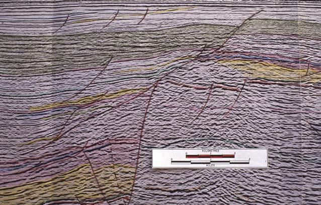
14 Inversion Structures, Western Barents

15 West Spitsbergen Fold- and Thrust Belt
16 Bergh and Grogan (2003) Comparison with WSFTB

17
18 Strain partitioning
.")

19 Figure 3 - Model setup a. Model setup, top view of basal plates. A thin plate is fixed at an angle of 15 degrees above an other plate that can be moved at a controlled rate. A, O: along strike and orthogonal components of total displacment. b. Model dimensions and materials, cross section. c. Stratigraphy of the WSFTB (Braathen and Bergh, 1995). Bold arrows indicate weak decoupling layers in Permian evaporites and Triassic and Jurassic shales; d. Mechanical stratigraphy of the model. Solid lines, brittle failure envelopes for quartz sand for different cohesion values according to eq. [4]; dashed line: brittle failure envelope according to Byerlee (1978) scaled down by a factor of 8 x 10 5 (see appendix for explanation). Viscous strength of PDMS for displacement rate of 5 cm/h. A ductile lower crust (cf. Burov, 2007) is not included in the model.


20 Building the model WSFTB-11: 30 o convergence angle Bars to constrain model thickness Basal plastic sheets White and colored sand Guiding bar Strap for pulling the lower plate 250 μm sieves WSFTB-9: 15 o convergence angle
21 km CS A1 A2 A3 A4 45 cm Figure 8 CS CS A1 A1 A2 A2 A3 A4 A3 35 cm 25 cm A4 Interpretation of selected cross sections (at 25, 35 and 45 cm, see Figure 7 for location) showing general characteristics and along strike variations. - Show also pictures - Show more details and deformation stages on model XS - Adapt numbering of A1- A5 - More modelling results cm
 Comparison with")
22 Bergh and Grogan (2003) Comparison with WSFTB
23 Provinces 1. West Spitsbergen fold & thrust belt 2. Asterias Fault Complex 3. Bjørnøyrenna Fault Complex 4. Vestbakken Volcanic Province 5. Sørvestsnaget Basin Timing 1. L.Palaeocene Eocene Faleide et al. (2008) Rift phases in W Barents Sea. Tertiary Cretaceous Jurassic Paleozoic
24 Asterias Fault Complex
25 Inversion Structures, Western Barents Sea The Asterias Fault Complex


26 Asterias Fault Complex
27 Provinces 1. West Spitsbergen fold & thrust belt 2. Asterias Fault Complex 3. Bjørnøyrenna Fault Complex 4. Vestbakken Volcanic Province 5. Sørvestsnaget Basin Timing 1. Hauterivian-Aptian 2. post Palaeocene Faleide et al. (2008) Rift phases in W Barents Sea. Tertiary Cretaceous Jurassic Paleozoic
28 Bjørnøyrenna Fault Complex

29 Inversion Structures, Western Barents The Bjørnøyrenna Fault Complex


30 Bjørnøyrenna Fault Complex
31 Provinces 1. West Spitsbergen fold & thrust belt 2. Asterias Fault Complex 3. Bjørnøyrenna Fault Complex 4. Vestbakken Volcanic Province 5. Sørvestsnaget Basin Timing 1.?Early - Late Cretaceous 2. post Palaeocene Faleide et al. (2008) Rift phases in W Barents Sea. Tertiary Cretaceous Jurassic Paleozoic
32 Sørvestsnaget Basin
33 Inversion Structures, Western Barents Sea The Sørvestsnaget Basin
")

34 Harsum (2009)


35 Mid Cretaceous Top early Eocene
36 Provinces 1. West Spitsbergen fold & thrust belt 2. Asterias Fault Complex 3. Bjørnøyrenna Fault Complex 4. Sørvestsnaget Basin 5. Vestbakken Volcanic Province Style and Timing Faleide et al. (2008) Rift phases in W Barents Sea. Tertiary Cretaceous 1.?L.Palaeocene E.Eocene; NW-SEstriking fold axes and inverted faults; Parallel high- and low-frequency folds 2. Eocene: NE-SW-striking folds and inverted faults Jurassic Paleozoic

37 Vestbakken Volcanic Province
 Vestbakken Volcanic")
38 Inversion Structures, Western Barents Sea (Grunnaleite 2002, 2008) Vestbakken Volcanic Province


39 RE05

40 Mid Miocene BV Wide, open collapsed anticlines and domes

41 Folds with moderately inclined axial surfaces focused along deep-seated faults


42 Flower and half-flower structures in footwall of some larger faults (undated) A
 Rift phases in W Barents Sea. Tertiary Cretaceous 1. Eocene Oligocene: open folding & doming 2.?Eocene Miocene: hangingwall folds and inverted faults 3.")
43 Provinces 1. West Spitsbergen fold & thrust belt 2. Asterias Fault Complex 3. Bjørnøyrenna Fault Complex 4. Sørvestsnaget Basin 5. Vestbakken Volcanic Province Style and Timing Faleide et al. (2008) Rift phases in W Barents Sea. Tertiary Cretaceous 1. Eocene Oligocene: open folding & doming 2.?Eocene Miocene: hangingwall folds and inverted faults 3. Flower structures of unknown age Jurassic Paleozoic
 A sheared margin along the southern Hornsund Fault Zone, from Bjørnøya to Sørkapp (74 30-76")
44 Margin segmentation A complex sheared and rifted margin along NW Svalbard and SW Yermak Plateau associated with volcanism (79-81 N). An initially sheared and later rifted margin west of Svalbard between Sørkapp and Kongsfjorden (76-79 N) A sheared margin along the southern Hornsund Fault Zone, from Bjørnøya to Sørkapp ( N), A rifted margin SW of Bjørnøya associated with volcanism ( N) A sheared margin along the Senja Fracture Zone ( N)


45 Time West Spitsbergen F&T Belt Asterias Fault Compl. Bjørnøyrenna Fault Complex Sørvestsnaget Basin Vestbakken Volc. Prov. Miocene Oligocene Eocene Palaeocene Late Cretaceous E.Cret.; Aptian - Hauterivian

46 Doré et al. (2008)
47 Cretaceous inversion? Inversion Structures, Western Barents Sea (Grunnaleite 2002, 2008)
48 Palaeocene - Miocene inversion; Contractional component? Inversion Structures, Western Barents Sea (Grunnaleite 2002, 2008)
 continent-continent passive")
49 Faleide et al. (2008) continent-continent passive Plate tectonic model

50 Lundin & Dore (2002) PETROBAR Tectonic inversion in the western Barents Sea Leever, Faleide, Gabrielsen, Grunnaleite
51 Conclusions Two distinct stages of inversion; Cretaceous (Hauterivian Albian?) and Palaeocene Miocene Cretaceous inversion most distinct along old basementinvolved fault complexes The Palaeogene event in the Sørvestsnaget Basin and the Vestbakken Volcanic Province oriented c.120 o to the transform > (right-lateral?) strike-slip The northernmost basin (VVP) has indications that inversion was active later (into Miocene times) there than farther south (SSB). Related to other plate tectonic stresses, like e.g. ridge push or domal uplift and spreading
Earth Science, (Tarbuck/Lutgens) Chapter 10: Mountain Building
 Chapter 10: Mountain Building") Earth Science, (Tarbuck/Lutgens) Chapter 10: Mountain Building 1) A(n) fault has little or no vertical movements of the two blocks. A) stick slip B) oblique slip C) strike slip D) dip slip 2) In a(n) fault,
Earth Science, (Tarbuck/Lutgens) Chapter 10: Mountain Building 1) A(n) fault has little or no vertical movements of the two blocks. A) stick slip B) oblique slip C) strike slip D) dip slip 2) In a(n) fault,
Deformation of Rocks. Orientation of Deformed Rocks
 Deformation of Rocks Folds and faults are geologic structures caused by deformation. Structural geology is the study of the deformation of rocks and its effects. Fig. 7.1 Orientation of Deformed Rocks
December 21, Chapter 11 mountain building E.notebook. Feb 19 8:19 AM. Feb 19 9:28 AM
 Mountains form along convergent plate boundaries. Typically (usually) if you look at a mountain range, you know that it is at a plate boundary (active continental margin) or has been some time in the past
Ruhr-Universität Bochum. Institute of Geology, Mineralogy and Geophysics. Structural analysis of inversion features of the Barents Sea
 Ruhr-Universität Bochum Institute of Geology, Mineralogy and Geophysics Structural analysis of inversion features of the Barents Sea Doctoral thesis by Muhammad Armaghan Faisal Miraj Bochum, 2017 Ruhr-Universität
Study the architecture and processes responsible for deformation of Earth s crust. Folding and Faulting
 Crustal Deformation AKA Structural geology (adapted from Brunkel, 2012) Study the architecture and processes responsible for deformation of Earth s crust. Folding and Faulting How Rocks Deform: 4 Controls
Learning Objectives (LO) What we ll learn today:!
 What we ll learn today:!") Learning Objectives (LO) Lecture 13: Mountain Building Read: Chapter 10 Homework #11 due Tuesday 12pm What we ll learn today:! 1. Define the types of stress that are present in the crust! 2. Define the
Learning Objectives (LO) Lecture 13: Mountain Building Read: Chapter 10 Homework #11 due Tuesday 12pm What we ll learn today:! 1. Define the types of stress that are present in the crust! 2. Define the
Chapter 15 Structures
 Chapter 15 Structures Plummer/McGeary/Carlson (c) The McGraw-Hill Companies, Inc. TECTONIC FORCES AT WORK Stress & Strain Stress Strain Compressive stress Shortening strain Tensional stress stretching
UNIT 10 MOUNTAIN BUILDING AND EVOLUTION OF CONTINENTS
 UNIT 10 MOUNTAIN BUILDING AND EVOLUTION OF CONTINENTS ROCK DEFORMATION Tectonic forces exert different types of stress on rocks in different geologic environments. STRESS The first, called confining stress
Chapter 16. Mountain Building. Mountain Building. Mountains and Plate Tectonics. what s the connection?
 Chapter 16 Mountains and Plate Tectonics what s the connection? Mountain Building Most crustal deformation occurs along plate margins. S.2 Active Margin Passive Margin Mountain Building Factors Affecting
Geologic Structures. Changes in the shape and/or orientation of rocks in response to applied stress
 Geologic Structures Changes in the shape and/or orientation of rocks in response to applied stress Figure 15.19 Can be as big as a breadbox Or much bigger than a breadbox Three basic types Fractures >>>
Figure 1. Examples of vector displacement diagrams for two and three-plate systems.
 Figure 1. Examples of vector displacement diagrams for two and three-plate systems. Figure 2. Relationships between pole of rotation, great circles, ridge segments, small circles, transforms and fracture
Answers: Internal Processes and Structures (Isostasy)
") Answers: Internal Processes and Structures (Isostasy) 1. Analyse the adjustment of the crust to changes in loads associated with volcanism, mountain building, erosion, and glaciation by using the concept
Answers: Internal Processes and Structures (Isostasy) 1. Analyse the adjustment of the crust to changes in loads associated with volcanism, mountain building, erosion, and glaciation by using the concept
Deformation of the Crust
 Deformation of the Crust Review Choose the best response. Write the letter of that choice in the space provided. 1. The state of balance between the thickness of the crust and the depth at which it rides
Stress and Strain. Stress is a force per unit area. Strain is a change in size or shape in response to stress
 Geologic Structures Geologic structures are dynamically-produced patterns or arrangements of rock or sediment that result from, and give information about, forces within the Earth Produced as rocks change
Chapter 10: Deformation and Mountain Building. Fig. 10.1
 Chapter 10: Deformation and Mountain Building Fig. 10.1 OBJECTIVES Describe the processes of rock deformation and compare and contrast ductile and brittle behavior in rocks. Explain how strike and dip
GEOL 321 Structural Geology and Tectonics
 GEOL 321 Structural Geology and Tectonics Geology 321 Structure and Tectonics will be given in Spring 2017. The course provides a general coverage of the structures produced by brittle and ductile rock
Crustal Deformation. Earth Systems 3209
 Crustal Deformation Earth Systems 3209 Crustal Deformation pg. 415 Refers to all changes in the original form and/or size of a rock body. May also produce changes in the location and orientation of rocks.
11.1 Rock Deformation
 Tarbuck Lutgens Mountain Building 11.1 Rock Deformation Factors Affecting Deformation Factors that influence the strength of a rock and how it will deform include temperature, confining pressure, rock
KEY CHAPTER 12 TAKE-HOME QUIZ INTERNAL STRUCTURES AND PROCESSES Score Part B = / 55 PART B
 GEOLOGY 12 KEY CHAPTER 12 TAKE-HOME QUIZ INTERNAL STRUCTURES AND PROCESSES Score Part B = / 55 PART B CHAPTER 12 Isostacy and Structural Geology 1. Using the terms below, label the following diagrams and
East Africa Transform Margin The View from Tanzania and Madagascar
 East Africa Transform Margin The View from Tanzania and Madagascar Richard Higgins and Mark Sofield 10 th PESGB/HGS Conference on African E & P, London, September 7-8, 2011 Acknowledgements Legal Notice:
Future giant discovery in the Outeniqua Basin, offshore South Africa. Anongporn Intawong & Neil Hodgson
 Future giant discovery in the Outeniqua Basin, offshore South Africa Anongporn Intawong & Neil Hodgson Spectrum Geoscience 23 February 2017 1 Talk Outlines Structural framework & Evolution of the South
Lecture 6 Folds, Faults and Deformation Dr. Shwan Omar
 Fold: A fold is a bend or wrinkle of rock layers or foliation; folds form as a sequence of ductile deformation. Folding is the processes by which crustal forces deform an area of crust so that layers of
Mountains and Mountain Building: Chapter 11
 Mountains and Mountain Building: Chapter 11 Objectives: 1)Explain how some of Earth s major mountain belts formed 2) Compare and contrast active and passive continental margins 3) Explain how compression,
The Sorong Fault Zone Kinematics: The Evidence of Divergence and Horsetail Structure at NW Bird's Head and Salawati Basin, West Papua, Indonesia*
 The Sorong Fault Zone Kinematics: The Evidence of Divergence and Horsetail Structure at NW Bird's Head and Salawati Basin, West Papua, Indonesia* Putri Riadini 1 and Benyamin Sapiie 2 Search and Discovery
Name. GEOL.5220 Structural Geology Faults, Folds, Outcrop Patterns and Geologic Maps. I. Properties of Earth Materials
 I. Properties of Earth Materials GEOL.5220 Structural Geology Faults, Folds, Outcrop Patterns and Geologic Maps Name When rocks are subjected to differential stress the resulting build-up in strain can
TECTONIC AND STRUCTURAL CONTROLS ON INTRUSION- RELATED DEPOSITS IN THE NORTHERN PART OF SREDNA GORA ZONE, BULGARIA NIKOLAY PETROV & KAMELIA NEDKOVA
 TECTONIC AND STRUCTURAL CONTROLS ON INTRUSION- RELATED DEPOSITS IN THE NORTHERN PART OF SREDNA GORA ZONE, BULGARIA NIKOLAY PETROV & KAMELIA NEDKOVA INVESTIGATED AREA Praveshka Lakavica deposit Elatsite
Essentials of Geology, 11e
 Essentials of Geology, 11e Crustal Deformation and Mountain Building Chapter 17 Instructor Jennifer Barson Spokane Falls Community College Geology 101 Stanley Hatfield Southwestern Illinois College Jennifer
The Lithosphere and the Tectonic System. The Structure of the Earth. Temperature 3000º ºC. Mantle
 The Lithosphere and the Tectonic System Objectives: Understand the structure of the planet Earth Review the geologic timescale as a point of reference for the history of the Earth Examine the major relief
How to Build a Mountain and other Geologic Structures. But first a short review
 How to Build a Mountain and other Geologic Structures But first a short review Where do we see deep earthquakes? What is happening there? What can happen at a plate boundary? 1. Plates can move apart
Structure of the western Brooks Range fold and thrust belt, Arctic Alaska
 Trabajos de Geología, Universidad de Oviedo, 29 : 218-222 (2009) Structure of the western Brooks Range fold and thrust belt, Arctic Alaska J. DE VERA 1* AND K. MCCLAY 2 1Now at: Shell, Rijswijk, Netherlands.
Global Tectonics. Kearey, Philip. Table of Contents ISBN-13: Historical perspective. 2. The interior of the Earth.
 Global Tectonics Kearey, Philip ISBN-13: 9781405107778 Table of Contents Preface. Acknowledgments. 1. Historical perspective. 1.1 Continental drift. 1.2 Sea floor spreading and the birth of plate tectonics.
Structural Modelling of Inversion Structures: A case study on South Cambay Basin
 10 th Biennial International Conference & Exposition P 065 Structural Modelling of Inversion Structures: A case study on South Cambay Basin Dr. Mayadhar Sahoo & S.K Chakrabarti Summary The inversion in
Play fairway mapping in the Northeast Atlantic Margin Comparison between mature and immature basins. David Mudge, Joanne Cranswick
 Play fairway mapping in the Northeast Atlantic Margin Comparison between mature and immature basins David Mudge, Joanne Cranswick Contents Ternan North Sea Play fairway mapping Tertiary case study Northeast
USU 1360 TECTONICS / PROCESSES
 USU 1360 TECTONICS / PROCESSES Observe the world map and each enlargement Pacific Northwest Tibet South America Japan 03.00.a1 South Atlantic Arabian Peninsula Observe features near the Pacific Northwest
Lab 7: STRUCTURAL GEOLOGY FOLDS AND FAULTS
 Lab 7: STRUCTURAL GEOLOGY FOLDS AND FAULTS This set of labs will focus on the structures that result from deformation in earth s crust, namely folds and faults. By the end of these labs you should be able
Implications of new long-offset seismic lines on the Norwegian Continental Shelf
 Implications of new long-offset seismic lines on the Norwegian Continental Shelf L. Gernigon Continental Shelf Geophysics, Geological Survey of Norway (NGU) Force seminar GWL/NGU BASMARGE Project Stavanger,
Tectonics and Hydrocarbon System, East Gobi Basin, Mongolia. Gary Prost, ConocoPhillips Canada, Calgary
 Tectonics and Hydrocarbon System, East Gobi Basin, Mongolia Gary Prost, ConocoPhillips Canada, Calgary Project Objectives (a joint project of Gulf Canada and ROC Oil) What structures can be expected in
4 Deforming the Earth s Crust
 CHAPTER 7 4 Deforming the Earth s Crust SECTION Plate Tectonics BEFORE YOU READ After you read this section, you should be able to answer these questions: What happens when rock is placed under stress?
Lecture Outline Friday March 2 thru Wednesday March 7, 2018
 Lecture Outline Friday March 2 thru Wednesday March 7, 2018 Questions? Lecture Exam Friday March 9, 2018 Same time, Same room Bring Pencils and WSU ID 50 question Multiple Choice, Computer Graded Interlude
Structural Styles and Geotectonic Elements in Northwestern Mississippi: Interpreted from Gravity, Magnetic, and Proprietary 2D Seismic Data
 Structural Styles and Geotectonic Elements in Northwestern Mississippi: Interpreted from Gravity, Magnetic, and Proprietary 2D Seismic Data Nick Loundagin 1 and Gary L. Kinsland 2 1 6573 W. Euclid Pl.,
Continental Margin Geology of Korea : Review and constraints on the opening of the East Sea (Japan Sea)
") Continental Margin Geology of Korea : Review and constraints on the opening of the East Sea (Japan Sea) Han-Joon Kim Marine Satellite & Observation Tech. Korea Ocean Research and Development Institute
Continental Margin Geology of Korea : Review and constraints on the opening of the East Sea (Japan Sea) Han-Joon Kim Marine Satellite & Observation Tech. Korea Ocean Research and Development Institute
We C2 06 Pre-Cretaceous Structural Development of the Leirdjupet Fault Complex and its Impact on Prospectivity, Southwestern Barents Sea, Norway
 We C2 06 Pre-Cretaceous Structural Development of the Leirdjupet Fault Complex and its Impact on Prospectivity, Southwestern Barents Sea, Norway K.H. Dittmers* (DEA Norge As), I. Kjørsvik (Wintershall
Directed Reading. Section: How Mountains Form MOUNTAIN RANGES AND SYSTEMS. Skills Worksheet
 Skills Worksheet Directed Reading Section: How Mountains Form 1. How high is Mount Everest? a. about 1980 km above sea level b. more than 8 km below sea level c. more than 8 km above sea level d. more
Deepwater Niger Delta fold-and-thrust belt modeled as a critical-taper wedge: The influence of a weak detachment on styles of fault-related folds
 Deepwater Niger Delta fold-and-thrust belt modeled as a critical-taper wedge: The influence of a weak detachment on styles of fault-related folds Frank Bilotti 1, Chris Guzofski 1, John H. Shaw 2 1 Chevron
Description of faults
 GLG310 Structural Geology Description of faults Horizontal stretch Crustal thickness Regional elevation Regional character Issues Normal Thrust/reverse Strike-slip >1 1 in one direction and < 1 in
Title. Author(s)Libak, Audun; Mjelde, Rolf; Keers, Henk; Faleide, Ja. CitationMarine Geophysical Research, 33(2): Issue Date
Libak, Audun; Mjelde, Rolf; Keers, Henk; Faleide, Ja. CitationMarine Geophysical Research, 33(2): Issue Date") Title An integrated geophysical study of Vestbakken Volcan adjacent oceanic crust Author(s)Libak, Audun; Mjelde, Rolf; Keers, Henk; Faleide, Ja CitationMarine Geophysical Research, 33(2): 185-207 Issue
Title An integrated geophysical study of Vestbakken Volcan adjacent oceanic crust Author(s)Libak, Audun; Mjelde, Rolf; Keers, Henk; Faleide, Ja CitationMarine Geophysical Research, 33(2): 185-207 Issue
Crags, Cracks, and Crumples: Crustal Deformation and Mountain Building
 Crags, Cracks, and Crumples: Crustal Deformation and Mountain Building Updated by: Rick Oches, Professor of Geology & Environmental Sciences Bentley University Waltham, Massachusetts Based on slides prepared
Depositional History and Petroleum Potential of Ombilin Basin, West Sumatra - Indonesia, Based on Surface Geological Data*
 Depositional History and Petroleum Potential of Ombilin Basin, West Sumatra - Indonesia, Based on Surface Geological Data* Yahdi Zaim 1, Litto Habrianta 2, Chalid I. Abdullah 1, Aswan 1, Yan Rizal 1, Nurcahyo
4 Deforming the Earth s Crust
 CHAPTER 7 4 Deforming the Earth s Crust SECTION Plate Tectonics BEFORE YOU READ After you read this section, you should be able to answer these questions: What happens when rock is placed under stress?
Topics Laramide Orogeny: Late Cretaceous to Early Eocene Reading: GSA DNAG volume 3, Ch. 6
 Topics Laramide Orogeny: Late Cretaceous to Early Eocene Reading: GSA DNAG volume 3, Ch. 6 Late Cretaceous to early Eocene New patterns developed 5 main regions Tectonic interpretations Post-Laramide events
Vail et al., 1977b. AAPG 1977 reprinted with permission of the AAPG whose permission is required for further use.
 Well 5 Well 4 Well 3 Well 2 Well 1 Vail et al., 1977b AAPG 1977 reprinted with permission of the AAPG whose permission is required for further use. Well 5 Well 4 Well 3 Well 2 Well 1 Vail et al., 1977b
Exam Deformatie en Metamorfose van de Korst Educatorium zaal ALFA
 Naam Studentnummer... Exam Deformatie en Metamorfose van de Korst Educatorium zaal ALFA Do not forget to put your name and student number on each of the question and answer sheets and to return both of
Chapter. Mountain Building
 Chapter Mountain Building 11.1 Rock Deformation Factors Affecting Deformation Factors that influence the strength of a rock and how it will deform include temperature, confining pressure, rock type, and
Perspectives from Offshore Argentina & Uruguay
 Perspectives from Offshore Argentina & Uruguay A Prospectivity Overview Hannah Kearns October 2018 Introduction Argentina Offshore License Round 1 14 blocks Argentina North, 24 Austral-Malvinas Offshore
Meandering Miocene Deep Sea Channel Systems Offshore Congo, West Africa
 Meandering Miocene Deep Sea Channel Systems Offshore Congo, West Africa S. Baer* (PGS), J. E. Comstock (PGS), K. Vrålstad (PGS), R. Borsato (PGS), M. Martin (PGS), J.P. Saba (SNPC), B. Débi-Obambé (SNPC)
Faults. Strike-slip fault. Normal fault. Thrust fault
 Faults Strike-slip fault Normal fault Thrust fault Fault any surface or narrow zone with visible shear displacement along the zone Normal fault Strike-slip fault Reverse fault Thrust fault
BALOCHISTAN FOLDBELT BASIN
 INTRODUCTION BALOCHISTAN FOLDBELT BASIN The Kharan-3 block is located in the Kharan Trough of Balochistan Basin. GEOLOGICAL SETTING The Balochistan Province is an Upper Cretaceous to Recent structurally
How to Build a Mountain and other Geologic Structures. But first, questions
 How to Build a Mountain and other Geologic Structures But first, questions Questions your students might ask How were Montana s mountains formed? How old are the mountains? What are the different ways
How mountains are made. We will talk about valleys (erosion and weathering later)
") How mountains are made We will talk about valleys (erosion and weathering later) http://www.ilike2learn.com/ilike2learn/mountainmaps/mountainranges.html Continent-continent plate convergence Less dense,
How mountains are made We will talk about valleys (erosion and weathering later) http://www.ilike2learn.com/ilike2learn/mountainmaps/mountainranges.html Continent-continent plate convergence Less dense,
GLY 155 Introduction to Physical Geology, W. Altermann. Press & Siever, compressive forces. Compressive forces cause folding and faulting.
 Press & Siever, 1995 compressive forces Compressive forces cause folding and faulting. faults 1 Uplift is followed by erosion, which creates new horizontal surface. lava flows Volcanic eruptions cover
Section 2: How Mountains Form
 Section 2: How Mountains Form Preview Objectives Mountain Ranges and Systems Plate Tectonics and Mountains Types of Mountains Objectives Identify the types of plate collisions that form mountains. Identify
Chapter Review USING KEY TERMS. asthenosphere uplift continental drift. known as. tectonic plates move. object. UNDERSTANDING KEY IDEAS
 Skills Worksheet Chapter Review USING KEY TERMS 1. Use the following terms in the same sentence: crust, mantle, and core. Complete each of the following sentences by choosing the correct term from the
Crustal Deformation Earth - Chapter Pearson Education, Inc.
 Crustal Deformation Earth - Chapter 10 Structural Geology Structural geologists study the architecture and processes responsible for deformation of Earth s crust. A working knowledge of rock structures
Mountains are then built by deforming crust: Deformation & Mountain Building. Mountains form where stresses are high!
 Deformation & Mountain Building Where are mountains located? Deformation and Folding Mountain building Mountains form where stresses are high! Mountains form at all three types of plate boundaries where
Geomorphology Final Exam Study Guide
 Geomorphology Final Exam Study Guide Geologic Structures STRUCTURAL GEOLOGY concerned with shapes, arrangement, interrelationships of bedrock units & endogenic (within) forces that cause them. Tectonic
Structural Geology of the Mountains
 Structural Geology of the Mountains Clinton R. Tippett Shell Canada Limited, Calgary, Alberta clinton.tippett@shell.ca INTRODUCTION The Southern Rocky Mountains of Canada (Figure 1) are made up of several
Earthquakes. Chapter Test A. Multiple Choice. Write the letter of the correct answer on the line at the left.
 Earthquakes Chapter Test A Multiple Choice Write the letter of the correct answer on the line at the left. 1. Stress that pushes a mass of rock in two opposite directions is called a. shearing. b. tension.
Plate Tectonics. entirely rock both and rock
 Plate Tectonics I. Tectonics A. Tectonic Forces are forces generated from within Earth causing rock to become. B. 1. The study of the origin and arrangement of Earth surface including mountain belts, continents,
Fault History analysis in Move
 Fault History analysis in Move The new Fault History plot in Move provides a method to conduct a quick-look analysis of the evolution of faults through time. By restoring the vertical displacement of a
Unit 4 Lesson 7 Mountain Building
 Indiana Standards 7.2.4 Explain how convection currents in the mantle cause lithospheric plates to move causing fast changes like earthquakes and volcanic eruptions, and slow changes like creation of mountains
Brittle Deformation. Earth Structure (2 nd Edition), 2004 W.W. Norton & Co, New York Slide show by Ben van der Pluijm
, 2004 W.W. Norton & Co, New York Slide show by Ben van der Pluijm") Lecture 6 Brittle Deformation Earth Structure (2 nd Edition), 2004 W.W. Norton & Co, New York Slide show by Ben van der Pluijm WW Norton, unless noted otherwise Brittle deformation EarthStructure (2 nd
Lecture 6 Brittle Deformation Earth Structure (2 nd Edition), 2004 W.W. Norton & Co, New York Slide show by Ben van der Pluijm WW Norton, unless noted otherwise Brittle deformation EarthStructure (2 nd
CRUSTAL DEFORMATION. Chapter 10
 CRUSTAL DEFORMATION and dgeologic Structures t Chapter 10 Deformation Df Deformation involves: Stress the amount of force applied to a given area. Types of Stress: Confining Stress stress applied equally
GEOLOGIC MAPS PART II
 EARTH AND ENVIRONMENT THROUGH TIME LABORATORY - EES 1005 LABORATORY FIVE GEOLOGIC MAPS PART II Introduction Geologic maps of orogenic belts are much more complex than maps of the stable interior. Just
Seismotectonics of intraplate oceanic regions. Thermal model Strength envelopes Plate forces Seismicity distributions
 Seismotectonics of intraplate oceanic regions Thermal model Strength envelopes Plate forces Seismicity distributions Cooling of oceanic lithosphere also increases rock strength and seismic velocity. Thus
Lecture Outlines PowerPoint. Chapter 10 Earth Science, 12e Tarbuck/Lutgens
 Lecture Outlines PowerPoint Chapter 10 Earth Science, 12e Tarbuck/Lutgens 2009 Pearson Prentice Hall This work is protected by United States copyright laws and is provided solely for the use of instructors
UNIVERSITY OF PRETORIA Department of Geology STRUCTURAL GEOLOGY -GLY 254 SEMESTER EXAM
 UNIVERSITY OF PRETORIA Department of Geology STRUCTURAL GEOLOGY -GLY 254 SEMESTER EXAM Copyright reserved 6 th June 2006 Time: 3 hours Internal examiner: Dr A.J. Bumby External examiner: Dr R. van der
Mohorovicic discontinuity separates the crust and the upper mantle.
 Structure of the Earth Chapter 7 The Earth is divided into 3 Main Layers 1. Crust outermost layer 1% of the Earth s mass thickness varies: 5 100 km two types: oceanic denser continental Mohorovicic discontinuity
Forces in Earth s Crust
 Forces in Earth s Crust This section explains how stresses in Earth s crust cause breaks, or faults, in the crust. The section also explains how faults and folds in Earth s crust form mountains. Use Target
Parts of the Sevier/ Laramide Orogeny
 Parts of the Sevier/ Laramide Orogeny AA. Accretionary Prism BB. Forearc Basin Sediment scraped off of subducting plate Sediment derived from the volcanic arc CC. Volcanic Arc Magmatic intrusion into the
Geomechanics for reservoir and beyond Examples of faults impact on fluid migration. Laurent Langhi Team Leader August 2014
 Geomechanics for reservoir and beyond Examples of faults impact on fluid migration Laurent Langhi Team Leader August 2014 Reservoir Geomechanics It is critical to understand the mechanical behaviour of
Structural Geology and Geology Maps Lab
 Structural Geology and Geology Maps Lab Mesa College Geology 101 Lab Ray Rector: Instructor Structural Geology Lab Pre-Lab Resources Pre-Lab Internet Links 1) Fundamentals of Structural Geology 2) Visualizing
Blocks 31, 32, 33, 34, 35 & 36/03 Southeast Offshore Vietnam
 Blocks 31, 32, 33, 34, 35 & 36/03 Southeast Offshore Vietnam Block 31 32 33 34 35 36/03 Area (km 2) 5,036 4,440 4,630 4,700 4,630 2,950 Sea level (m) 20 20-30 30-40 50 50 50 Seismic 2D (km) 1,294 685 431
A comparison of structural styles and prospectivity along the Atlantic margin from Senegal to Benin. Peter Conn*, Ian Deighton* & Dario Chisari*
 A comparison of structural styles and prospectivity along the Atlantic margin from Senegal to Benin Overview Peter Conn*, Ian Deighton* & Dario Chisari* * TGS, Millbank House, Surbiton, UK, KT6 6AP The
Continental Landscapes
 Continental Landscapes Landscape influenced by tectonics, climate & differential weathering Most landforms developed within the last 2 million years System moves toward an equilibrium Continental Landscapes
SEDIMENTARY BASINS BASIN TYPES ACCORDING TO TECTONIC. by Prof. Dr. Abbas Mansour
 SEDIMENTARY BASINS BASIN TYPES ACCORDING TO TECTONIC by Prof. Dr. Abbas Mansour B. Convergent plate margins 10. STABLE CONTINENTAL INTERIOR BASIN E.g. Lake Eyre Basin Intracratonic (= within stable continental
Forces That Shape Earth. How do continents move? What forces can change rocks? How does plate motion affect the rock cycle?
 Forces That Shape Earth How do continents move? What forces can change rocks? How does plate motion affect the rock cycle? Plate Motion Mountain ranges are produced by plate tectonics. The theory of plate
Structural analysis of the Måsøy Fault Complex in the SW Barents Sea
 Master Thesis in Geosciences Structural analysis of the Måsøy Fault Complex in the SW Barents Sea Muhammad Aftab Structural analysis of the Måsøy Fault Complex in the SW Barents Sea. Muhammad Aftab Master
The chapters in part I provide new and valuable
 PART I TECTONICS AND STRUCTURE OF SUPERCONTINENT BREAKUP 2 Introduction Martha Oliver Withjack and Roy W. Schlische The chapters in part I provide new and valuable information about the tectonic and structural
We A Multi-Measurement Integration Case Study from West Loppa Area in the Barents Sea
 We-16-12 A Multi-Measurement ntegration Case Study from West Loppa Area in the Barents Sea. Guerra* (WesternGeco), F. Ceci (WesternGeco), A. Lovatini (WesternGeco), F. Miotti (WesternGeco), G. Milne (WesternGeco),
Before Plate Tectonics: Theory of Continental Drift
 Before Plate Tectonics: Theory of Continental Drift Predecessor to modern plate tectonics Shape and fit of the continents was the initial evidence Snider-Pelligrini (1858) Taylor (1908) Wegner (1915) Fig.
Unit 4 Lesson 3 Mountain Building. Copyright Houghton Mifflin Harcourt Publishing Company
 Stressed Out How can tectonic plate motion cause deformation? The movement of tectonic plates causes stress on rock structures. Stress is the amount of force per unit area that is placed on an object.
Elastic models of deformation in nature: why shouldn t we use the present day fault geometry?
 Elastic models of deformation in nature: why shouldn t we use the present day fault geometry? B. Freeman 1, G. Yielding, 1 S.J. Dee 1, 2, & P.G. Bretan 1 1 Badley Geoscience Limited, UK 2 BP Exploration
Strike-Slip Faults. ! Fault motion is parallel to the strike of the fault.
 Strike-Slip Faults! Fault motion is parallel to the strike of the fault.! Usually vertical, no hanging-wall/footwall blocks.! Classified by the relative sense of motion. " Right lateral opposite block
Petroleum Geology and Exploration History of the Mergui Basin, THAILAND EPPM (P1) PROJECT
 PROJECT") Petroleum Geology and Exploration History of the Mergui Basin, THAILAND EPPM (P1) PROJECT KRABI, THAILAND 12 th May 2009 Contents of Presentation 1. Exploration History 1. Exploration History 2. General
Petroleum Geology and Exploration History of the Mergui Basin, THAILAND EPPM (P1) PROJECT KRABI, THAILAND 12 th May 2009 Contents of Presentation 1. Exploration History 1. Exploration History 2. General
ANOTHER MEXICAN EARTHQUAKE! Magnitude 7.1, Tuesday Sept. 19, 2017
 ANOTHER MEXICAN EARTHQUAKE! Magnitude 7.1, Tuesday Sept. 19, 2017 Why is there no oceanic crust older than 200 million years? SUBDUCTION If new oceanic crust is being continuously created along the earth
NATURAL ENVIRONMENT. Geophysics
 NATURAL ENVIRONMENT Geophysics Geodynamics Alpine, Carpathian and Dinaric mountain belts surround the Pannonian (Carpathian) Basin, of Neogene through Quaternary in age. The Cenozoic evolution of the Alpine-Pannonian
Name Student ID Exam 2c GEOL 1113 Fall 2009
 Name Student ID Exam 2c GEOL 1113 Fall 2009 1. When a marine geologist collects a core of undeformed ocean-floor sediment, she knows that the youngest layer is on the top of the core and the oldest is
IRAQ. Target Exploration. Geodynamic Evolutions of The Sedimentary Basins of. This study is a major reference for Petroleum
 barr Target Exploration Target Exploration Geodynamic Evolutions of The Sedimentary Basins of IRAQ This study is a major reference for Petroleum Explorationists on the tectonics, stratigraphy, sedimentary
Captain s Tryouts 2017
 Captain s Tryouts 2017 Dynamic Planet Test Written by: Araneesh Pratap (Chattahoochee High School) Name: Date: Answer all questions on the answer sheet. Point values are given next to each question or
Non-ideal Subduction
 Subduction zone cross sections Earthquake locations : black = teleseismic est. gray = local-array est. red line = top of slab seismicity blue line = center of slab seismicity Non-ideal Subduction Oblique