DOUBLE DUTCH. truth and tale on historical references used by nature developers in the Dutch wetland areas. Chris de Bont historical geographer at
|
|
|
- Toby Collins
- 5 years ago
- Views:
Transcription

1 DOUBLE DUTCH truth and tale on historical references used by nature developers in the Dutch wetland areas Chris de Bont historical geographer at Wageningen University
2 1 introduction

3 1357 Natio Anglica Natio Picardia Meuse river
4 north redrawn detail of the so-called Parisian map
5 north redrawn detail of the so-called Parisian map

6 the catastrophe on St. Elizabeths-day 1421: the grave of more than people? (16th century dyptich Rijksmuseum Amsterdam)
7 detail Parisian map area flooded areas in 1421
8 2 some questions

9 what is the relation between the old maps of the wetland areas and the historical geography of these areas? map surroundings of Amsterdam (reconstruction) th

10 map Amsterdam, 16 th century or, to be more precise: to what extend reflect old maps the history of reclamation, habitation and historical water management?..are nature developers dealing with this old map nformation while changing the cultural landscape?

11 where in the Netherlands the wetlands are situated map Amsterdam, 16 th century

12 map Amsterdam, 16 th century how they differ in historical geography
13 and what kind of relics are being preserved into the present-day landscape, taking into account the sometimes enormous landscape dynamics in the wetland areas during the last thousand years map Amsterdam, mid-20 th century

14 landscape dynamics are to be determinated from historical maps and... how these images influenced ideas on nature development map Amsterdam, mid-20 th century
15 3 wetlands in the Netherlands from an historical geographic point of view


16 Dutch historical geographic GIS Histland
17 The Dutch historical geographic GIS Histland gives, among other information: on different scales an indication of the history of topographical structures and relics in the present-day landscape
18 ar ydrologic situation before the first reclamations started

19 back swamp and levee reclamations ar mediaeval peat reclamations peat colonies older mars polders recent mars polder drained lakes (in Dutch: droogmakerij middle ages ydrologic situation before the first reclamations started
20 land periodically flooded by the sea if there had been no sea- or river dikes
21 GIS Histland

22 increasing sea influence from the north-west during the centuries heavily changed an original, very regular peat reclamation structure

23 soil map Alterra
24 4 struggle against the sea...
25 GIS Histland

26 1250 A.D.: defensive embankment activities

27 detail Parisian map area flooded areas in 1421

28 1600 A.D.: defensive and offensive embankment activities

29 ? map from 1560 A.D.

30 water instead of land, end of the 16 th century

31 South polder new land: offensive embankment activities, beginning of the 17 th century
32 South polder mid-17 th century
33 South South polder polder end end-17 th century

34 South polder present-day situation

35 dike breach in the late 18 th century

36 and people and their livestock found all kind of save havens


37


38 1953

39 people had to be evacuated from the central river area, within one day

40 map early 18 th century

41 time defensive dike systems

42 etching 17 th century

43 the sea dikes were perforated by a tiny shellfish: the pile-worm etching 17 th century


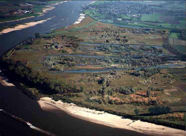
44 the gunpowder-holes used for breaking the boulder stone are still
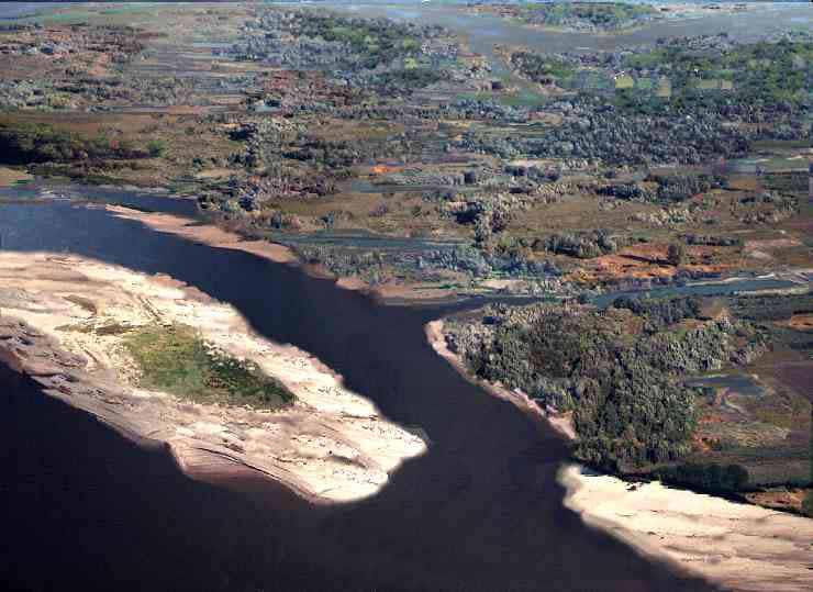
45 many tons of boulders were imported

46 old-fashioned sea dike newly built sea dike etching mid-18 th century


47 1953-flooding


48 ...the northern older marspolders,, with their typical dwelling mounds...
49 5 the central river area

50

51 central river area in The Netherlands

52 river dynamics between 12th - 20th century

53

54 first dikes

55

56

57 closed (circular) river dike system
58 oldest settlements iver basin sandy levee river sandy levee before 12-13th century
59 dike dike from 12-13th century onwards

60 dike dike
61 breach dike dike

62 river RAF-photo 1944 dike breach - sediment dike

63 Romanesque church near the dike
64 river Romanesque church near the dike


65 some centuries ago excavated nearby

66 regularize and rectificate the main course of the rivers within 60 years, as a result of clever groin management, the river has deepened and inland waterway shipping was possible now
67 6 mediaeval peat reclamations
68 mediaval peat reclamations
69 mediaval peat reclamations
70 mediaval peat reclamations

71 map TMK 1850
72 The Netherlands around 800 A.D.

73
74
75 1 2 shifting occupation axes

76 ...wooden farmhouses...

77

78

79
80
81
82

83

84
 map")
85 relocated lineair villages (peat dome) map TMK 1850

86

87
88
89

90

91 early 18 th century map...the sketched developments are visible...

92 mid-19 th century map

93 recent topographical map

94 present-day situation
95

96

97

98 odern topographical map odern topographical map m m or or 1 1 furlong furlong
99

100
101 6 ongoing change
102 The Netherlands around 800 A.D.
103 Mediaeval peat reclamations GIS Histland

104
105 the horizontally and vertically striped areas in this GIS Histland map make the landscape dynamics in the mediaeval peat reclamation areas visible Histland map

106 Histland map I will give an idea of the more specific changes in the original mediaeval topographical structure and the physical forces which initiated them
107
108 mixed farming
109
110
111

112

113 800 A.D. Geldern Valley for more specific landscape dynamics in the Dutch peat reclamation areas we must go more into detail, in, for example the Geldern Valley, where peat had grown between two ice-pushed ridges
114 map TMK 1850
115 map TMK 1850

116 map TMK 1850
117 7 dredge, drain, and reclaim

118

119 the principle of the voorboezem or preliminary storage area

120 the first drainage by wind powered water mills near Delft village around 1440 AD

121 drainage by wind powered water mills near Delft village around 1550 AD

122 wind powered windmills in Delfland in 1611 projected on the 1713 map of the De Kruik, or Cruiqius brothers

123 the so-called baggerbeugel, with which peat could be dredged below groundwater level

124 dredged peatland, now water 17 th century map

125 1950-situation
126 drained and reclaimed lakes map GIS Histland


127

128 situation mid-19 th century

129 situation 10 years later

130 the Dutch abroad
131 8 land consolidation

132 land consolidation adage: use all available techniques

133 ...parcellation structure of a late mediaeval peat- dome reclamation.. map TMK 1850

134 ...parcellation structure after a land consolidation project had been carried out recent map

135 parcellation structure of the original late mediaeval peat ridge reclamation map TMK 1850

136 recent map parcellation structure after a very radical land consolidation project

137 map: 17 th century

138 land consolidation and reallotment schemes The Netherlands Belgium

139 medieval peat reclamation area - 1,5 m drained and 19th century reclaimed fortress lake -44 m new nature area -11 m inland peat dikes - 0,5 m al these phenomenon combined in one picture
140 9 developing nature the double Dutch way
141 Rhine, and it s branches Scheldt Meuse

142

143 ...a blissful moment in the past...

144 1995 they should have known better...

145

146 th

147

148
149

150
151

152

153

154

155
156

157

158

159 ...truth and tale on historical references used by nature developers in the Dutch wetlands, as well as in the wetlands troughout Europe
160 10 towards the end...
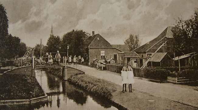
161 north redrawn detail of the so-called Parisian map

162 ...topographical map

163 ...combined with a modern satelite map of altitudes...

164 ...early mediaeval branche of the river Meuse

165


166 thank you very much for your patience and kind attention
167

168 and this is wat is left over from the once mighty river Meuse,, not even 1 kilometer was saved during the enormous changes caused by the land consolidation in the 1970-ties

169 door de dijkdoorbraak van de Kethelpolder in 1903
Sedimentation Rate Change in the Winooski River Delta
 Sedimentation Rate Change in the Winooski River Delta Chris Ricker and Brian Connelly Abstract Historical air photographs, from 1937 show the Winooski River Delta extended much farther into Lake Champlain
1 General introduction
 1 General introduction 1.1 Framework of the project Biography of the New Land One of the largest enterprises undertaken by the Dutch government in the 20 th century was the reclamation of the Zuiderzee,
Changes to Land 5.7B. landforms: features on the surface of Earth such as mountains, hills, dunes, oceans and rivers
 All the landforms on Earth have changed over time and continue to change. Many of the changes were caused by wind, moving water, and moving ice. Mountains have grown and shrunk. Rivers have cut away land
PART 5 MECHANISMS OF GROUND SETTLEMENT IN GREATER NEW ORLEANS
 PART 5 MECHANISMS OF GROUND SETTLEMENT IN GREATER NEW ORLEANS Predicted water depth in New Orleans flood inundation area based on water level of 2.37 ft in Lake Ponchartrain on Sept 2, 2005. Overlay on
Think about the landforms where you live. How do you think they have changed over time? How do you think they will change in the future?
 reflect All the landforms on Earth have changed over time and continue to change. Many of the changes were caused by wind, moving water, and moving ice. Mountains have grown and shrunk. Rivers have cut
Influence of the Major Drainages to the Mississippi River and Implications for System Level Management
 Influence of the Major Drainages to the Mississippi River and Implications for System Level Management Brian M. Vosburg Geologist Louisiana Coastal Protection and Restoration Authority brian.vosburg@la.gov
Science EOG Review: Landforms
 Mathematician Science EOG Review: Landforms Vocabulary Definition Term canyon deep, large, V- shaped valley formed by a river over millions of years of erosion; sometimes called gorges (example: Linville
W he natural resources of Adams
 Above: Houghton Rock, Town of Adams. Following Page: "The Hole in the Rock" on Rattlesnake Mound--both remnants of rock formed by ancient seas hundreds of millions of year5 ago. (Courtesy, H.H. Bennett
Social Studies 9 UNIT 2 GEOGRAPHIC INFLUENCES ON IDENTITY: PLACE AND PEOPLE
 Social Studies 9 UNIT 2 GEOGRAPHIC INFLUENCES ON IDENTITY: PLACE AND PEOPLE The Structure of the Earth To understand the forces that create Canada's physical landscape we must understand the structure
Weathering, Erosion, Deposition
 Weathering, Erosion, Deposition The breakdown of rocks at or near the Earth s Surface. Physical Chemical - The breakdown of rock into smaller pieces without chemical change. - Dominant in moist /cold conditions
2 Georgia: Its Heritage and Its Promise
 TERMS region, erosion, fault, elevation, Fall Line, aquifer, marsh, climate, weather, precipitation, drought, tornado, hurricane, wetland, estuary, barrier island, swamp PLACES Appalachian Mountains, Appalachian
ACTON COMMUNITY WIDE ARCHAEOLOGICAL RECONNAISSANCE SURVEY. Town of Acton and PAL, Inc.
 ACTON COMMUNITY WIDE ARCHAEOLOGICAL RECONNAISSANCE SURVEY Town of Acton and PAL, Inc. Objectives and Scope of Work Four phase study; (1. research, 2. draft report outline, resource protection bylaw, 3.
Your web browser (Safari 7) is out of date. For more security, comfort and the best experience on this site: Update your browser Ignore
 is out of date. For more security, comfort and the best experience on this site: Update your browser Ignore") Your web browser (Safari 7) is out of date. For more security, comfort and the best experience on this site: Update your browser Ignore DOGGERL AND - THE EU RO PE THAT WAS The British Isles were once neither
Your web browser (Safari 7) is out of date. For more security, comfort and the best experience on this site: Update your browser Ignore DOGGERL AND - THE EU RO PE THAT WAS The British Isles were once neither
How does erosion happen?
 How does erosion happen? By National Geographic, adapted by Newsela staff on 10.03.17 Word Count 682 Level 830L These rock formations, in Bryce Canyon National Park, Utah, are called hoodoos. Although
APPENDIX D QUESTIONS/ACTIVITIES FOR TEACHERS AND STUDENTS
 APPENDIX D QUESTIONS/ACTIVITIES FOR TEACHERS AND STUDENTS The questions below are intended for teachers as they educate K-12 Geography students using the Japanese American relocation centers as their focal
4th Grade U.S. Regional Geography
 4th Grade U.S. Regional Geography Multiple Choice Identify the choice that best completes the statement or answers the question. What does the term mainland mean in the sentence above? A the continent
Paper presented in the Annual Meeting of Association of American Geographers, Las Vegas, USA, March 2009 ABSTRACT
 Paper presented in the Annual Meeting of Association of American Geographers, Las Vegas, USA, March 2009 ABSTRACT CHANGING GEOMORPHOLOGY OF THE KOSI RIVER SYSTEM IN THE INDIAN SUBCONTINENT Nupur Bose,
Sediment management: a european perspective. Piet den Besten Centre for Water Management Rijkswaterstaat, Netherlands
 Sediment management: a european perspective Piet den Besten Centre for Water Management Rijkswaterstaat, Netherlands Content Background of Dutch-German exchange (DGE plus) What is needed for adequate sediment
Location, Location, Location: the Construction and Preservation of Roman Burial Mounds in the Dutch River Delta
 Special Volume 3 (2012), pp. 155 159 Marjolein T.I.J. Bouman Kirsten van Kappel Linda P. Verniers Location, Location, Location: the Construction and Preservation of Roman Burial Mounds in the Dutch River
Chapter 11. Rivers: Shaping our landscape
 Chapter 11 Rivers: Shaping our landscape Learning outcomes In this presentation you will learn: Common terms associated with rivers About the three stages of a river About the processes of river erosion
Mapping Diversity in Old and New Netherland
 Your web browser (Safari 7) is out of date. For more security, comfort and Activityengage the best experience on this site: Update your browser Ignore Mapping Diversity in Old and New Netherland How did
The Geology of Sebago Lake State Park
 Maine Geologic Facts and Localities September, 2002 43 55 17.46 N, 70 34 13.07 W Text by Robert Johnston, Department of Agriculture, Conservation & Forestry 1 Map by Robert Johnston Introduction Sebago
ARCHAEOLOGICAL METHOD FEHMARN STYLE
 ARCHAEOLOGICAL METHOD FEHMARN STYLE Digital archaeology By: Nadja M. K. Mortensen, Prehistoric Archaeologist, Responsible for GIS Overview of the survey area Digital measuring and registration are an important
PART 4 HURRICANE KATRINA STRIKES NEW ORLEANS AUGUST 2005
 PART 4 HURRICANE KATRINA STRIKES NEW ORLEANS AUGUST 2005 Hurricane Katrina Hurricane Katrina swept across southern Florida and lost momentum, then gained speed and water, showing the second lowest barometric
Terrain Units PALEOGEOGRAPHY: LANDFORM CREATION. Present Geology of NYS. Detailed Geologic Map of NYS
 NYS TOPOGRAPHY Why so? PALEOGEOGRAPHY: LANDFORM CREATION Prof. Anthony Grande AFG 014 Present Geology of NYS Detailed Geologic Map of NYS Generalized Geology Detailed Geology Hot links to the fold out
PALEOGEOGRAPHY of NYS. Definitions GEOLOGIC PROCESSES. Faulting. Folding 9/6/2012. TOPOGRAPHIC RELIEF MAP of NYS GRADATIONAL TECTONIC
 TOPOGRAPHIC RELIEF MAP of NYS PALEOGEOGRAPHY of NYS Prof. Anthony Grande AFG 2012 Definitions GEOLOGIC PROCESSES Geography: study of people living on the surface of the earth. Geology: the scientific study
World Industrial Regions
 World Industrial Regions North America Industrialized areas in North America Changing distribution of U.S. manufacturing Europe Western Europe Eastern Europe East Asia Manufacturing Regions Fig. 11-3:
CARD #1 The Shape of the Land: Effects of Crustal Tilting
 CARD #1 The Shape of the Land: Effects of Crustal Tilting When we look at a birds-eye view of the Great Lakes, it is easy to assume the lakes are all at a similar elevation, but viewed in this way, we
State the principle of uniformitarianism. Explain how the law of superposition can be used to determine the relative age of rocks.
 Objectives State the principle of uniformitarianism. Explain how the law of superposition can be used to determine the relative age of rocks. Compare three types of unconformities. Apply the law of crosscutting
Tips for Success on a Test
 Number of Incorrect: Final Grade: Parent Signature: Top Tips for Success on a Test 1. Read the following statements at least two times. 2. Circle the key words in each question/ or statement. (*Remember
CHAPTER 1: EXPLORING GEOGRAPHY
 CHAPTER 1: EXPLORING GEOGRAPHY Please Do Now: In your PDN section of your binder answer the following with one or two sentences: What is Geography? What is Geography? The study of where people, places,
Year 6. Geography. Revision
 Year 6 Geography Revision November 2017 Rivers and World knowledge How the water cycle works and the meaning of the terms evaporation, condensation, precipitation, transpiration, surface run-off, groundwater
Weathering and Erosion
 Have you ever looked at the land around you and wondered how it was shaped? The geologic features that help define the world are still being shaped by the natural processes of weathering, erosion, and
Coimisiún na Scrúduithe Stáit State Examinations Commission
 S28 WARNING You must return this paper with your answer book, otherwise marks will be lost. Write your Examination Number here Coimisiún na Scrúduithe Stáit State Examinations Commission JUNIOR CERTIFICATE
Geog Lecture 19
 Geog 1000 - Lecture 19 Fluvial Geomorphology and River Systems http://scholar.ulethbridge.ca/chasmer/classes/ Today s Lecture (Pgs 346 355) 1. What is Fluvial Geomorphology? 2. Hydrology and the Water
Chapter 6, Part Colonizers arriving in North America found extremely landscapes. It looked different to region showing great.
 Social Studies 9 Unit 1 Worksheet Chapter 6, Part 1. 1. Colonizers arriving in North America found extremely landscapes. It looked different to region showing great. 2. The Earth is years old and is composed
Active Coastal Processes in the Lubec Embayment
 The Lubec Embayment Maine Geologic Facts and Localities August, 1998 Active Coastal Processes in the Lubec Embayment 44 49 50.51 N, 66 59 34.16 W Text by Joseph T. Kelley, Department of Agriculture, Conservation
2. WETLAND MAP FOR NORTH WEST EUROPE K Cousserier
 2. WETLAND MAP FOR NORTH WEST EUROPE K Cousserier Introduction As part of the Planarch 2, Action 2A, a digital wetlands map for NWE was developed as one of the common outputs of the project. The map defines
 Red River Flooding June 2015 Caddo and Bossier Parishes Presented by: Flood Technical Committee Where the Rain Falls Matters I-30 versus I-20 I-20 Backwater and Tributary Floods (Localized) 2016 Flood
Landscape. Review Note Cards
 Landscape Review Note Cards Last Ice Age Pleistocene Epoch that occurred about 22,000 Years ago Glacier A large, long lasting mass of ice which forms on land and moves downhill because of gravity. Continental
Topic Page: Floodplains
 Topic Page: Floodplains Definition: f loodplain from The Penguin English Dictionary a low-lying area beside a river that is composed of sedimentary deposits and is subject to periodic flooding. Summary
Geography. Programmes of study for Key Stages 1-3
 Geography Programmes of study for Key Stages 1-3 February 2013 Contents Purpose of study 3 Aims 3 Attainment targets 3 Subject content 4 Key Stage 1 4 Key Stage 2 5 Key Stage 3 6 2 Purpose of study A high-quality
Chapter 3 Erosion and Deposition. The Big Question:
 Chapter 3 Erosion and Deposition The Big Question: 1 Design a way to represent and describe the 4 types of mass movement. You may use pictures, diagrams, list, web, chart, etc 2 Chapter 3: Erosion and
Archaeological Predictive Modeling within the context of Paleo-river Terraces in the City of Prince George
 Archaeological Predictive Modeling within the context of Paleo-river Terraces in the City of Prince George Background The documented pre-contact archaeological record of the Interior Plateau of B.C. is
GEOGRAPHY. Written examination. Thursday 14 November 2002
 Victorian Certificate of Education 2002 SUPERVISOR TO ATTACH PROCESSING LABEL HERE Figures Words STUDENT NUMBER Letter GEOGRAPHY Written examination Thursday 14 November 2002 Reading time: 11.45 am to
Moosehead Lake and the Tale of Two Rivers
 Maine Geologic Facts and Localities June, 2005 45 o 53 5.09 N, 69 o 42 14.54 W Text by Kelley, A.R.; Kelley, J.T.; Belknap, D.F.; and Gontz, A.M. Department of Earth Sciences, University of Maine, Orono,
MANAGEMENT OF SPATIAL DATA IN MULTIDISCIPLINARY PROJECTS
 MANAGEMENT OF SPATIAL DATA IN MULTIDISCIPLINARY PROJECTS Ir. B.P.J. van den Bergh Resource Analysis Dr. Ir. A. de Vries IWACO BV Working Group IC-19, TC IV-3, WG IV/6 KEY WORDS: Spatial Data Management,
Diagnostic Geomorphic Methods for Understanding Future Behavior of Lake Superior Streams What Have We Learned in Two Decades?
 Diagnostic Geomorphic Methods for Understanding Future Behavior of Lake Superior Streams What Have We Learned in Two Decades? Faith Fitzpatrick USGS WI Water Science Center, Middleton, WI fafitzpa@usgs.gov
Fate of historic metal releases from the Coeur d Alene mining district Northern Idaho
 Fate of historic metal releases from the Coeur d Alene mining district Northern Idaho Stephen E. Box US Geological Survey U.S. Metal Production Coeur d'alene, ID Butte, MT Tintic-East Tintic, UT Ag (10
The subject paper is being submitted for approval for publication in the annual volume entitled Geological Survey Research.
 Water Resources Division 345 Middlefield Road Menlo Park, California January 12, 1965 Memorandum To: Mr. Frank E. Clark, Chief, General Hydrology Branch Thru: Area Hydrologist PCA From: Valmore C. LaMarche
Range of Opportunities
 Geograhy Curriculum Cropwell Bishop Primary School Range of Opportunities Year 1 Year 2 Year 3 Year 4 Year 5 Year 6 All Key Stage 1 Key Stage 2 Investigate the countries and capitals of the United Kingdom.
The Coast: Beaches and Shoreline Processes Trujillo & Thurman, Chapter 10
 The Coast: es and Shoreline Processes Trujillo & Thurman, Chapter 10 Oceanography 101 Chapter Objectives Recognize the various landforms characteristic of beaches and coastal regions. Identify seasonal
Geography is the study of the earth, it s land, it s people and it s environments. When you study geography, you should be looking at five distinct
 I.N pg. 9 Geography is the study of the earth, it s land, it s people and it s environments. When you study geography, you should be looking at five distinct themes. LOCATION PLACE REGION MOVEMENT HUMANENVIRONMENTAL
B. Topographic maps are also called. contour maps
 Topographic Maps Introduction A. Topographic maps are essential tools in geologic and engineering studies because they show the configuration of Earth's surface in remarkable detail and permit one to measure
The Driftless Area. Dave Speer Geography 326
 The Driftless Area Dave Speer Geography 326 Introduction: Wisconsin s landscape is defined by many physical features resulting from continental glaciation. Wisconsin is unique in the fact that it possesses
New A-Level Physical Geography
 Half Term 1 3.1 Physical Geography: 3.1.5 Hazards: Plate Tectonics This optional section of our specification focuses on the lithosphere and the atmosphere, which intermittently but regularly present natural
Controlling Processes That Change Land
 1 Name Date Controlling Processes That Change Land People try to control some of the processes that change land. To do this, people apply technology- the use of science to solve problems in everyday life.
Section 5. Low-Gradient Streams. What Do You See? Think About It. Investigate. Learning Outcomes
 Chapter 4 Surface Processes Section 5 Low-Gradient Streams What Do You See? Learning Outcomes In this section, you will Use models and real-time streamflow data to understand the characteristics of lowgradient
Cattaraugus Creek: A Story of Flowing Water and the Geology of the Channel It Flows Through Presentation to West Valley Citizen Task Force 4/27/16
 Cattaraugus Creek: A Story of Flowing Water and the Geology of the Channel It Flows Through Presentation to West Valley Citizen Task Force 4/27/16 Raymond C. Vaughan, Ph.D. What happens if you drop a
Fresh Water: Streams, Lakes Groundwater & Wetlands
 Fresh Water:, Lakes Groundwater & Wetlands Oct 27 Glaciers and Ice Ages Chp 13 Nov 3 Deserts and Wind and EXAM #3 Slope hydrologic cycle P = precip I = precip intercepted by veg ET = evapotranspiration
Tuition, Medical and Behaviour Support Service
 Tuition, Medical and Behaviour Support Service Curriculum Policy - Primary Geography Reviewed: October 2018 Next Review: October 2019 Responsibility: Andrea Snow AIMS AND PRINCIPLES The national curriculum
2007: The Netherlands in a drought again (2 May 2007)
") 2007: The Netherlands in a drought again (2 May 2007) Henny A.J. van Lanen, Wageningen University, the Netherlands (henny.vanlanen@wur.nl) Like in June and July 2006, the Netherlands is again facing a
2007: The Netherlands in a drought again (2 May 2007) Henny A.J. van Lanen, Wageningen University, the Netherlands (henny.vanlanen@wur.nl) Like in June and July 2006, the Netherlands is again facing a
Lecture 15: Subsidence
 Lecture 15: Subsidence Key Questions 1. How does removal of groundwater cause subsidence on a regional scale? 2. Under what conditions does a building sink into sediment? 3. Why do clays consolidate more
Pee Dee Explorer. Science Standards
 Science Standards About Pee Dee Explorer What does it mean when someone says they are from the "Pee Dee" of South Carolina? A place is bigger than its physical geography. A "sense of place" weaves together
Coimisiún na Scrúduithe Stáit State Examinations Commission
 2013. S27 WARNING You must return this paper with your answer book. Otherwise marks will be lost. Write your Examination Number here: Coimisiún na Scrúduithe Stáit State Examinations Commission JUNIOR
Removal of riverbank protection along the River Rhine (the Netherlands)
") RR 2004 3rd European Conference on River Restoration RIVER RESTORATION 2004 Zagreb, Croatia, 17-21 May 2004 Removal of riverbank protection along the River Rhine (the Netherlands) L.J. Bolwidt, H.E.J.
RR 2004 3rd European Conference on River Restoration RIVER RESTORATION 2004 Zagreb, Croatia, 17-21 May 2004 Removal of riverbank protection along the River Rhine (the Netherlands) L.J. Bolwidt, H.E.J.
GEOL 1121 Earth Processes and Environments
 GEOL 1121 Earth Processes and Environments Wondwosen Seyoum Department of Geology University of Georgia e-mail: seyoum@uga.edu G/G Bldg., Rm. No. 122 Seyoum, 2015 Chapter 6 Streams and Flooding Seyoum,
Read Across America. Listen as I read for facts about Volcanoes. In the Shadow of the Volcano
 Read Across America Listen as I read for facts about Volcanoes. In the Shadow of the Volcano Constructive & Destructive Processes Earth s surface is always changing. Blowing wind and flowing water causes
CONFINED DISPOSAL FACILITY (CDF) SLUFTER: A PERFECT SOLUTION FOR CONTAMINATED SEDIMENT IN NORTHWEST EUROPE.
 SLUFTER: A PERFECT SOLUTION FOR CONTAMINATED SEDIMENT IN NORTHWEST EUROPE.") CONFINED DISPOSAL FACILITY (CDF) SLUFTER: A PERFECT SOLUTION FOR CONTAMINATED SEDIMENT IN NORTHWEST EUROPE. Ronald Rutgers Msc Port of Rotterdam Authority Asset Manager, Assetmanagement Ports & Fairways
CONFINED DISPOSAL FACILITY (CDF) SLUFTER: A PERFECT SOLUTION FOR CONTAMINATED SEDIMENT IN NORTHWEST EUROPE. Ronald Rutgers Msc Port of Rotterdam Authority Asset Manager, Assetmanagement Ports & Fairways
Erosion and Deposition
 CHAPTER 3 LESSON 2 Erosion and Deposition Landforms Shaped by Water and Wind Key Concepts What are the stages of stream development? How do water erosion and deposition change Earth s surface? How do wind
Page 1. Name:
 Name: 1) Which property would best distinguish sediment deposited by a river from sediment deposited by a glacier? thickness of sediment layers age of fossils found in the sediment mineral composition
Historical floods of the Rhine river, reconstructed from the sedimentary fills of a dike breach pond and abandoned channels
 BSc L.H.J. Aloserij Historical floods of the Rhine river, reconstructed from the sedimentary fills of a dike breach pond and abandoned channels Application for estimation of the design discharge Date:
PHYSICAL GEOGRAPHY. By Brett Lucas
 PHYSICAL GEOGRAPHY By Brett Lucas FLUVIAL PROCESSES Fluvial Processes The Impact of Fluvial Processes on the Landscape Streams and Stream Systems Stream Channels Structural Relationships The Shaping and
The Use of GIS with property maps
 e-perimetron, Vol.1, No. 4, Autumn 2006 [297-307] www.e-perimetron.org ISSN 1790-3769 Elger Heere The Use of GIS with property maps Keywords: historical cartography; property maps; GIS; map use; users
Your web browser (Safari 7) is out of date. For more security, comfort and the best experience on this site: Update your browser Ignore
 is out of date. For more security, comfort and the best experience on this site: Update your browser Ignore") Your web browser (Safari 7) is out of date. For more security, comfort and the best experience on this site: Update your browser Ignore ALLU VIAL FAN colluvial fan, debris cone For the complete encyclopedic
Your web browser (Safari 7) is out of date. For more security, comfort and the best experience on this site: Update your browser Ignore ALLU VIAL FAN colluvial fan, debris cone For the complete encyclopedic
NEW. Junior Certificate Geography. LiamAshe Kieran McCarthy
 NEW Junior Certificate Geography LiamAshe Kieran McCarthy THE EDUCATIONAL COMPANY OF IRELAND Contents Section 1 Physical Geography Chapter 1 The Earth 1.1 The Solar System 1.2 The Structure of Earth 1.3
5 th Grade Social Studies Goals for the First Trimester Miss Gaull
 5 th Grade Social Studies Goals for the First Trimester Overview: American People, American Land The American People Government by the People Free Enterprise Lands and Regions Resources and the Environment
PiXL Independence: Geography Answer Booklet KS4. AQA Style, UK Physical Landscapes. Contents: Answers
 PiXL Independence: Geography Answer Booklet KS4 AQA Style, UK Physical Landscapes Contents: Answers 1 I. Multiple Choice Questions 1 Where in the UK would you describe as having large areas of uplands?
Peat Dikes and Strength Parameters Unexpected Results By A. Tomczak 1
 Peat Dikes and Strength Parameters Unexpected Results By A. Tomczak 1 About 26% of the Netherlands lies below sea level while 55% is susceptible to flooding, therefore dikes are an essential part of the
Nursery. Reception. Year 1
 Nursery Geography Overview Autumn Spring Summer Notices detailed features of objects in their environment. Comments and asks questions about aspects of their familiar world such as the place where they
Fluvial Features of the Arkansas River and Floodplain near Dardanelle, Arkansas
 Fluvial Features of the Arkansas River and Floodplain near Dardanelle, Arkansas Master Naturalist Field Trip: April 16, 2010 Trip Leader: Cathy Baker, Ph. D. Arkansas Tech University A. Objectives of Field
The Coast: Beaches and Shoreline Processes
 1 2 3 4 5 6 7 8 9 The Coast: es and Shoreline Processes Trujillo & Thurman, Chapter 10 Oceanography 101 Chapter Objectives Recognize the various landforms characteristic of beaches and coastal regions.
Erosional Features. What processes shaped this landscape?
 Have you ever looked at the land around you and wondered what processes shaped what you see? Perhaps you see mountains, valleys, rivers, or canyons. Do you know how long these geologic features have been
Infrared Images and Land Cover in the Past
 Ekológia (Bratislava) Vol. 32, No. 4, p. 383 387, 2013 doi:10.2478/eko-2013-0036 Infrared Images and Land Cover in the Past Václav Ždímal Mendel University in Brno, Zemědělská 1, 613 00 Brno, Czech Republic;
1- Water on Earth 2- Oceans and seas / continental waters 3- Uses, risks and problems of water
 Contents: I- Relief 1- Structure of the Earth and relief formation 2- Shaping of relief 3- Types of relief II- Water 1- Water on Earth 2- Oceans and seas / continental waters 3- Uses, risks and problems
How Britain became an island
 How Britain became an island Philip Gibbard Cambridge Quaternary, Department of Geography, University of Cambridge, Cambridge, England Island Britain is separated from the European continent by the English
Gully erosion and associated risks in the Tutova basin Moldavian Plateau
 Landform Analysis, Vol. 17: 193 197 (2011) Gully erosion and associated risks in the Tutova basin Moldavian Plateau University Alexandru Ioan Cuza of Iasi, Department of Geography, Romania, e-mail: catiul@yahoo.com
Chapter 2: Physical Geography
 Chapter 2: Physical Geography Pg. 39-68 Learning Goals for Chp2: q q q q q Explain how the Earth moves in space and why seasons change. Outline the factors that influence climate and recognize different
Earth processes are dynamic actions that occur both on
 29 Weathering, Erosion, and Deposition R EA D I N G Earth processes are dynamic actions that occur both on the earth s surface and inside the earth. Any process that breaks down earth material, such as
Vocabulary Words. theory continental drift fault magma lava. weathering glacier erosion deposition delta
 Earth s Landforms Vocabulary Words theory continental drift fault magma lava weathering glacier erosion deposition delta Theory: A possible explanation. Continental drift: The continuing movement of the
Evaluation/Monitoring Report No. 152
 Evaluation/Monitoring Report No. 152 150m west of 7 Portmore Rd. Portmore Lower Ballinderry County Antrim LICENCE NO.: AE/07/241 David McIlreavy 1 Site Specific Information Site Name Townland County :
PSc 201 Chapter 3 Homework. Critical Thinking Questions
 PSc 201 Chapter 3 Homework Critical Thinking Questions 1. (adapted from text) Seawater is denser than fresh water. A ship moving from the Atlantic Ocean into the Great Lakes goes from seawater to fresh
e Southeast Region of the United Statesg
 e Southeast of the United Statesg - relative location: the location of a place in relation to another place (i.e. south, near, bordering, next to) - barrier islands: located off the southeast coast of
Geography Mile Post 1
 Mile Post 1 Use world maps, atlases and globes to identify the UK and its countries, as well as the countries, continents and oceans studied at this key stage Key Skills IPC learning Goals 1.11 Be able
Geography Class XI Fundamentals of Physical Geography Section A Total Periods : 140 Total Marks : 70. Periods Topic Subject Matter Geographical Skills
 Geography Class XI Fundamentals of Physical Geography Section A Total Periods : 140 Total Marks : 70 Sr. No. 01 Periods Topic Subject Matter Geographical Skills Nature and Scope Definition, nature, i)
Geology of Havering-atte-Bower
 Geology of Havering-atte-Bower The geology of Havering village consists of deposits of clays, gravels and sands variously classed as bedrock and superficial deposits. Clays and sands seem rather dull but
Factors Affecting Human Settlement
 Factors Affecting Human Settlement Physical Factors One of the most basic factors affecting settlement patterns is the physical geography of the land. Climate is key, because if a place is too dry, too
Physical Geography A Living Planet
 Physical Geography A Living Planet The geography and structure of the earth are continually being changed by internal forces, like plate tectonics, and external forces, like the weather. Iguaçu Falls at
Exploring Geography. Chapter 1. Chapter 1, Section
 Chapter 1, Section World Geography Chapter 1 Exploring Geography Copyright 2003 by Pearson Education, Inc., publishing as Prentice Hall, Upper Saddle River, NJ. All rights reserved. Chapter 1, Section
The maps in this resource can be freely modified and reproduced in the classroom only.
 Teacher's Notes In this activity, students work collaboratively to explore sections of old and new maps. By closely examining these documents, students learn to see maps as more than just tools for locating