Dr.Ismail Bulent GUNDOGDU
|
|
|
- Jessica Hancock
- 5 years ago
- Views:
Transcription

1 A NEW APPROACH FOR GEOGRAPHICAL INFORMATION SYSTEM-SUPPORTED MAPPING OF TRAFFIC ACCIDENT DATA Dr.Ismail Bulent GUNDOGDU Selcuk University, Engineering and Architecture Faculty Geodesy and Photogrammetry Dept. Konya,TURKEY FIG Working Week 008 in Stockholm, Sweden 4-9 June 008 Author s name(s) (Ismail Bulent GUNDOGDU, Fatih SARI, Omur ESEN) 6 June 008 Contents: What is the aim? The importance of traffic accidents World Health Organisation( WHO) and World Bank Questionares What is Hot Spot? Hot Pieces ( HPCS) Method Probable Hot Spots ( PRHS) Data Evaluation Results


2 The mportance of Traffic Accidents. Increasing world population and corresponding vehicle count create new problems in traffic-flow. 3 Rapidly-increasing mortality and injury from traffic accidents now have a notable priority. 4
3 According to WHO and WB, on road traffic accidents and injuries estimated. million people are killed in road crashes 50 million are injured worldwide (Rathinam et al.,007) each year. Estimation of the World Bank, traffic accidents will be the third reason of death in A questionnaire done by 800 people whose relatives lost their lives in traffic accidents in European countries: 37% of those had tendency to commit a suicide 64% of those had depression in subsequent 3 years Another questionnaire done by 40 people in Turkey 50% of 40 people suffered from insomnia, 39.% suffered from hysteria in addition to depression 6 3

 are traditionally termed hotspots, hotpoints or occasionally")
4 The main reasons of traffic accidents : straight roads speed sleepiness and inattention substantially curved roads with a limited view or in forest or sloping areas. weather conditions... 7 What is Hot Spot? The significantly different areas detected by the applied statistics (usually termed LISA: Local Indicators of Spatial Autocorrelation) are traditionally termed hotspots, hotpoints or occasionally hotbeds 8 4


5 The importance of GIS Geographic Information System GIS is the most effective way of examining and evaluating the results of analyses which use a multitude of data and different criteria. 9 Determining and illustrating Hot spots. 0 5


6 Since the Hot Spot concept started to appear in accident analysis, literature has cited many methods for detecting Hot Spots. These are as known commonly: Kernel Estimation Method Getis Ord Gi Tract or Grid Scanning Ellipsoid Scanning In this study, Kernel Density Estimation and Getis Ord Gi methods has been used to determine Hot Spots.. Application 6
 Routes 3 Accident Data Data will be evaluated Maps")
7 Total roads length: 957km./ 6 939km Konya highways: 74km. Junctions: 03 Accident: 37 Accident rate: 8 th Mortality rate: 3 th Injury rate : 5 th (from 006 official statistics) Routes 3 Accident Data Data will be evaluated Maps and Satellite images Ms Access Coordinates ArcGIS 9. Statistical Analysis Products Graphics Product Result Maps 4 7
8 Differences of this study from the others. HPCS (Hot Pieces) Representation Method. PRHS (Probable Hot Spot) or Probable Pieces Representation Method 5 HPCS METHOD Each piece is km. Total pieces number=
9 KM PIECES 7 HOT PIECES NORMAL PIECES RISKY PIECES 8 9
. The basic goal of PRHS is to anticipate and prevent premature accidents. Two Methods are used to determine PRHS. Getis ord Gi.")
10 General view of all highways 9 PRHS METHOD (Probable Hot Spot illustration ) One of the most vital and important innovations of this study is Probable Hot Spots (PRHS). The basic goal of PRHS is to anticipate and prevent premature accidents. Two Methods are used to determine PRHS. Getis ord Gi. Kernel Density Estimation 0 0

11 GETS ORD G The statistics Gi and Gi*, introduced by Getis and Ord (99) for the study of local patterns in spatial data, were extended and re-written in 995. G ( d) = * i * * wij ( d) xj Wi x j { ( i) i /( ) } * * * s ns W n / Gi values on junctions calculated by accident number

 has")


12 Kernel Density Estimation The Kernel method introduced by Rosenblatt (956) has received considerable attention in nonparametric estimation of probability densities N pˆ( x) = Kσ ( x xi ) N i= 3 4

13 General view of all highway s spots by Kernel Density Estimation 5 NORMAL AREAS HOT AREAS PROBABLE AREAS 6 3

14 Accident number distribution 7 8 4

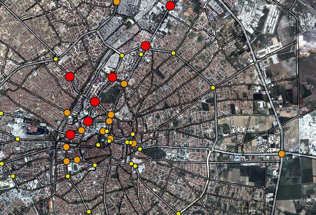
15 HOT SPOTS PROBABLE NORMAL 9 Relations of probable Hot Spots with normal Hot Spots on junction points by Getis Ord Gi. 30 5

16 Result Map 3 RESULT TABLE Necessary accident number to be Hot Spot Urban area junctions Route Route Route 3 Route 4 Route 5 Route 6 Route 7 PRHS Number th priority th th th th th th th th th th th th th th th Total
17 Thank you
The Use of Geographical Information Systems. in Historic and Cultural Places. Case Study: Town of Side. Omur ESEN
 The Use of Geographical Information Systems in Historic and Cultural Places Case Study: Town of Side Omur ESEN Selcuk University, Office of Construction and Infrastructure Dept. Konya,TURKEY omuresen@hotmail.com
A New Approach for Geographical Information System-Supported Mapping of Traffic Accident Data
 A New Approach for Geographical Information System-Supported Mapping of Traffic Accident Data Ismail Bulent GUNDOGDU, Fatih SARI and Omur ESEN, Turkey Keywords: Mapping, Linear clusters, GIS, Traffic accidents,
Texas A&M University
 Texas A&M University CVEN 658 Civil Engineering Applications of GIS Hotspot Analysis of Highway Accident Spatial Pattern Based on Network Spatial Weights Instructor: Dr. Francisco Olivera Author: Zachry
Investigation of the Effect of Transportation Network on Urban Growth by Using Satellite Images and Geographic Information Systems
 Presented at the FIG Congress 2018, May 6-11, 2018 in Istanbul, Turkey Investigation of the Effect of Transportation Network on Urban Growth by Using Satellite Images and Geographic Information Systems
Using GIS to Identify Pedestrian- Vehicle Crash Hot Spots and Unsafe Bus Stops
 Using GIS to Identify Pedestrian-Vehicle Crash Hot Spots and Unsafe Bus Stops Using GIS to Identify Pedestrian- Vehicle Crash Hot Spots and Unsafe Bus Stops Long Tien Truong and Sekhar V. C. Somenahalli
A COMPARATIVE STUDY OF THE APPLICATION OF THE STANDARD KERNEL DENSITY ESTIMATION AND NETWORK KERNEL DENSITY ESTIMATION IN CRASH HOTSPOT IDENTIFICATION
 A COMPARATIVE STUDY OF THE APPLICATION OF THE STANDARD KERNEL DENSITY ESTIMATION AND NETWORK KERNEL DENSITY ESTIMATION IN CRASH HOTSPOT IDENTIFICATION Yue Tang Graduate Research Assistant Department of
Spatiotemporal Analysis of Urban Traffic Accidents: A Case Study of Tehran City, Iran
 Spatiotemporal Analysis of Urban Traffic Accidents: A Case Study of Tehran City, Iran January 2018 Niloofar HAJI MIRZA AGHASI Spatiotemporal Analysis of Urban Traffic Accidents: A Case Study of Tehran
Comparison of spatial methods for measuring road accident hotspots : a case study of London
 Journal of Maps ISSN: (Print) 1744-5647 (Online) Journal homepage: http://www.tandfonline.com/loi/tjom20 Comparison of spatial methods for measuring road accident hotspots : a case study of London Tessa
SASI Spatial Analysis SSC Meeting Aug 2010 Habitat Document 5
 OBJECTIVES The objectives of the SASI Spatial Analysis were to (1) explore the spatial structure of the asymptotic area swept (z ), (2) define clusters of high and low z for each gear type, (3) determine
Implication of GIS Technology in Accident Research in Bangladesh
 Journal of Bangladesh Institute of Planners ISSN 2075-9363 Vol. 8, 2015 (Printed in December 2016), pp. 159-166, Bangladesh Institute of Planners Implication of GIS Technology in Accident Research in Bangladesh
Estimating Traffic Accidents in Turkey Using Differential Evolution Algorithm
 SSP - JOURNAL OF CIVIL ENGINEERING Vol. 12, Issue 1, 2017 DOI: 10.1515/sspjce-2017-0008 Estimating Traffic Accidents in Turkey Using Differential Evolution Algorithm Ali Payıdar Akgüngör, Ersin Korkmaz
Analysis & Prediction of Road Accident Data for Indian States
 Analysis & Prediction of Road Accident Data for Indian States Abstract Ashutosh Gupta Civil Engineering Department MMMUT Gorakhpur, India. This paper studies Linear trend mathematical model which is based
AN ARTIFICIAL NEURAL NETWORK MODEL FOR ROAD ACCIDENT PREDICTION: A CASE STUDY OF KHULNA METROPOLITAN CITY
 Proceedings of the 4 th International Conference on Civil Engineering for Sustainable Development (ICCESD 2018), 9~11 February 2018, KUET, Khulna, Bangladesh (ISBN-978-984-34-3502-6) AN ARTIFICIAL NEURAL
Lecture 4. Spatial Statistics
 Lecture 4 Spatial Statistics Lecture 4 Outline Statistics in GIS Spatial Metrics Cell Statistics Neighborhood Functions Neighborhood and Zonal Statistics Mapping Density (Density surfaces) Hot Spot Analysis
The Analysis of Traffic Accidents in Erzurum Province and Its Districts Through Use of Geographical Information Systems
 Journal of Traffic and Logistics Engineering Vol. 3, No. 2, December 2015 The Analysis of Traffic Accidents in Erzurum Province and Its Districts Through Use of Geographical Information Systems Ahmet Tortum1,
GENERATION OF 3D CITY MODELS FROM TERRESTRIAL LASER SCANNING AND AERIAL PHOTOGRAPHY: A CASE STUDY
 GENERATION OF 3D CITY MODELS FROM TERRESTRIAL LASER SCANNING AND AERIAL PHOTOGRAPHY: A CASE STUDY Hakan KARABORK 1, Fatih SARI 1 1 Selcuk University in Konya, Faculty of Engineering and Architecture Konya,
Texas A&M University, Zachry Department of Civil Engineering
 Texas A&M University, Zachry Department of Civil Engineering Instructor: Dr. Francisco Olivera CVEN658 Civil Engineering Applications of GIS Using Geographical Information Systems to Organize Police Patrol
EVALUATION OF HOTSPOTS IDENTIFICATION USING KERNEL DENSITY ESTIMATION (K) AND GETIS-ORD (G i *) ON I-630
 AND GETIS-ORD (G i *) ON I-630") EVALUATION OF HOTSPOTS IDENTIFICATION USING KERNEL DENSITY ESTIMATION (K) AND GETIS-ORD (G i *) ON I-630 Uday R. R. Manepalli Graduate Student, Civil, Architectural and Environmental Engineering, Missouri
EVALUATION OF HOTSPOTS IDENTIFICATION USING KERNEL DENSITY ESTIMATION (K) AND GETIS-ORD (G i *) ON I-630 Uday R. R. Manepalli Graduate Student, Civil, Architectural and Environmental Engineering, Missouri
Luc Anselin Spatial Analysis Laboratory Dept. Agricultural and Consumer Economics University of Illinois, Urbana-Champaign
 GIS and Spatial Analysis Luc Anselin Spatial Analysis Laboratory Dept. Agricultural and Consumer Economics University of Illinois, Urbana-Champaign http://sal.agecon.uiuc.edu Outline GIS and Spatial Analysis
ENHANCING ROAD SAFETY MANAGEMENT WITH GIS MAPPING AND GEOSPATIAL DATABASE
 Abstract ENHANCING ROAD SAFETY MANAGEMENT WITH GIS MAPPING AND GEOSPATIAL DATABASE Dr Wei Liu GHD Reliable and accurate data are needed in each stage of road safety management in order to correctly identify
Pedestrian Accident Analysis in Delhi using GIS
 Pedestrian Accident Analysis in Delhi using GIS Shalini RANKAVAT a, Geetam TIWARI b a Research Scholar, Indian Institute of Technology, New Delhi, 110016, India; E-mail: shalini.rankavat@gmail.com b Professor,
GIS INTEGRATION OF DATA COLLECTED BY MOBILE GPSSIT
 GIS INTEGRATION OF DATA COLLECTED BY MOBILE GPSSIT S.Savaş DURDURAN, Özşen ÇORUMLUOĞLU, Đbrahim KALAYCI and Fatih GÜL Selcuk University, Geodesy and Photogrammetry Dept. Konya-TURKĐYE ABSTRACT: Rapid developments
AN ANALYSIS ON THE TRAFFIC ACCIDENTS TOURIST AT CASE STUDY: NANTOU COUNTY
 AN ANALYSIS ON THE TRAFFIC ACCIDENTS TOURIST AT CASE STUDY: NANTOU COUNTY Jau-Ming Su 1, Yu-Ming Wang 2 1 Chung Hua University, Ph.D.program of Technology Management, No. 707, Sec. 2, WuFu Rd., Hsin Chu,
Daniel Fuller Lise Gauvin Yan Kestens
 Examining the spatial distribution and relationship between support for policies aimed at active living in transportation and transportation behavior Daniel Fuller Lise Gauvin Yan Kestens Introduction
USING GEOGRAPHICAL INFORMATION SYSTEMS TO EFFECTIVELY ORGANIZE POLICE PATROL ROUTES BY GROUPING HOT SPOTS OF CRASH AND CRIME DATA
 USING GEOGRAPHICAL INFORMATION SYSTEMS TO EFFECTIVELY ORGANIZE POLICE PATROL ROUTES BY GROUPING HOT SPOTS OF CRASH AND CRIME DATA Pei-Fen Kuo Research Assistant, Zachry Department of Civil Engineering,
Application of GIS to Traffic Accident Analysis: Case Study of Naypyitaw-Mandalay Expressway (Myanmar)
") Application of GIS to Traffic Accident Analysis: Case Study of Naypyitaw-Mandalay Expressway (Myanmar) Kyaw Zin Htut a, Ei Ei Mon b, Leonard Johnstone c, Rattaphol Pueboobpaphan d, Vatanavongs Ratanavaraha
Application of GIS to Traffic Accident Analysis: Case Study of Naypyitaw-Mandalay Expressway (Myanmar) Kyaw Zin Htut a, Ei Ei Mon b, Leonard Johnstone c, Rattaphol Pueboobpaphan d, Vatanavongs Ratanavaraha
Geospatial Big Data Analytics for Road Network Safety Management
 Proceedings of the 2018 World Transport Convention Beijing, China, June 18-21, 2018 Geospatial Big Data Analytics for Road Network Safety Management ABSTRACT Wei Liu GHD Level 1, 103 Tristram Street, Hamilton,
How GIS Can Help With Tribal Safety Planning
 How GIS Can Help With Tribal Safety Planning Thomas A. Horan, PhD Brian Hilton, PhD Arman Majidi, MAIS Center for Information Systems and Technology Claremont Graduate University Goals & Objectives This
LOCATION OF PREHOSPITAL CARE BASIS THROUGH COMBINED FUZZY AHP AND GIS METHOD
 ISAHP Article: Mu, Saaty/A Style Guide for Paper Proposals To Be Submitted to the LOCATION OF PREHOSPITAL CARE BASIS THROUGH COMBINED FUZZY AHP AND GIS METHOD Marco Tiznado Departamento de Ingeniería Industrial,
Using GIS to Evaluate Rural Emergency Medical Services (EMS)
") Using GIS to Evaluate Rural Emergency Medical Services (EMS) Zhaoxiang He Graduate Research Assistant Xiao Qin Ph.D., P.E. Associate Professor Outline Introduction Literature Review Study Design Data Collection
Using GIS to Evaluate Rural Emergency Medical Services (EMS) Zhaoxiang He Graduate Research Assistant Xiao Qin Ph.D., P.E. Associate Professor Outline Introduction Literature Review Study Design Data Collection
STATISTICAL ANALYSIS OF LAW ENFORCEMENT SURVEILLANCE IMPACT ON SAMPLE CONSTRUCTION ZONES IN MISSISSIPPI (Part 1: DESCRIPTIVE)
") STATISTICAL ANALYSIS OF LAW ENFORCEMENT SURVEILLANCE IMPACT ON SAMPLE CONSTRUCTION ZONES IN MISSISSIPPI (Part 1: DESCRIPTIVE) Tulio Sulbaran, Ph.D 1, David Marchman 2 Abstract It is estimated that every
STATISTICAL ANALYSIS OF LAW ENFORCEMENT SURVEILLANCE IMPACT ON SAMPLE CONSTRUCTION ZONES IN MISSISSIPPI (Part 1: DESCRIPTIVE) Tulio Sulbaran, Ph.D 1, David Marchman 2 Abstract It is estimated that every
Spatiotemporal Patterns of Coral Bleaching and Disease along the Florida Reef Tract. Brian K. Walker & Amanda Costaregni
 Spatiotemporal Patterns of Coral Bleaching and Disease along the Florida Reef Tract Brian K. Walker & Amanda Costaregni Congratulations!! Objectives 1. Identify areas where spatial clustering of significantly
GIS-BASED VISUALIZATION FOR ESTIMATING LEVEL OF SERVICE Gozde BAKIOGLU 1 and Asli DOGRU 2
 Presented at the FIG Congress 2018, May 6-11, 2018 in Istanbul, Turkey GIS-BASED VISUALIZATION FOR ESTIMATING LEVEL OF SERVICE Gozde BAKIOGLU 1 and Asli DOGRU 2 1 Department of Transportation Engineering,
MAPPING OF NOISE BY USING GIS IN ŞANLIURFA. 1. Introduction
 Environmental Monitoring and Assessment (2006) 121: 103 108 DOI: 10.1007/s10661-005-9109-1 c Springer 2006 MAPPING OF NOISE BY USING GIS IN ŞANLIURFA GUZEL YILMAZ and YUKSEL HOCANLI Engineering Faculty,
Hypothesis Testing. Week 04. Presented by : W. Rofianto
 Hypothesis Testing Week 04 Presented by : W. Rofianto Tests about a Population Mean: σ unknown Test Statistic t x 0 s / n This test statistic has a t distribution with n - 1 degrees of freedom. Example:
THE NEW CHALLENGES FOR THE HIGHER EDUCATION OF GEODESY IN UACEG SOFIA
 THE NEW CHALLENGES FOR THE HIGHER EDUCATION OF GEODESY IN UACEG SOFIA Ivan Kunchev University of Architecture, Civil Engineering and Geodesy, 1 Hristo Smirnenski Blvd., Sofia 1046, Bulgaria Abstract Report
Local Spatial Autocorrelation Clusters
 Local Spatial Autocorrelation Clusters Luc Anselin http://spatial.uchicago.edu LISA principle local Moran local G statistics issues and interpretation LISA Principle Clustering vs Clusters global spatial
Winter weather and municipal winter road maintenance
 Winter weather and municipal winter road maintenance Marie Eriksson 1 and Alf Johansson 2 1 Marie Eriksson, PhD, Klimator AB, Earth Sciences Centre, Box 460, SE-405 30 Göteborg, SWEDEN. E-mail: mariee@gvc.gu.se,
GIS-BASED VISUALISATION OF TRAFFIC NOISE
 Proceedings of the 9 th International Conference on Environmental Science and Technology Rhodes island, Greece, 1 3 September 2005 GIS-BASED VISUALISATION OF TRAFFIC NOISE A. KONSTANTINIDIS 1, K. EVANGELIDIS
COMMUNITY EMERGENCY RESPONSE TEAM TORNADOES
 Tornadoes are powerful, circular windstorms that may be accompanied by winds in excess of 200 miles per hour. Tornadoes typically develop during severe thunderstorms and may range in width from several
Tornadoes pose a high risk because the low atmospheric pressure, combined with high wind velocity, can:
 Tornadoes are powerful, circular windstorms that may be accompanied by winds in excess of 200 miles per hour. Tornadoes typically develop during severe thunderstorms and may range in width from several
Encapsulating Urban Traffic Rhythms into Road Networks
 Encapsulating Urban Traffic Rhythms into Road Networks Junjie Wang +, Dong Wei +, Kun He, Hang Gong, Pu Wang * School of Traffic and Transportation Engineering, Central South University, Changsha, Hunan,
Using Of Remote Sensing Data and Geographical Information System To Determine The Optimum Paths For Health Services
 Using Of Remote Sensing Data and Geographical Information System To Determine The Optimum Paths For Health Services Rayan Ghazi Thannoun 1, Sabah Hussein Ali 2, Raya Thamer Mustafa 3 1,2 : Remote Sensing
The use of GIS tools for road infrastructure safety management
 The use of GIS tools for road infrastructure safety management Marcin Budzyński 1,*, Wojciech Kustra 1, Romanika Okraszewska 1, Kazimierz Jamroz 1, and Jerzy Pyrchla 2 1 Gdansk University of Technology,
EUROPEAN INVESTMENT BANK
 EUROPEAN INVESTMENT BANK RISC Consortium and the UNU-CRIS Summer School/ Students Research Symposium, 3 rd July 2012, Luxembourg Regional Projects good practice? Kamil Dörfler 1 Outline General background
THE DEVELOPMENT OF ROAD ACCIDENT DATABASE MANAGEMENT SYSTEM FOR ROAD SAFETY ANALYSES AND IMPROVEMENT
 THE DEVELOPMENT OF ROAD ACCIDENT DATABASE MANAGEMENT SYSTEM FOR ROAD SAFETY ANALYSES AND IMPROVEMENT By T. H. Law Radin Umar R. S. (Road Safety Research Center, Faculty of Engineering, University Putra
PRIORITIZATION OF ACCIDENT BLACK SPOTS USING GIS
 Website: www.ijetae.com (ISSN 50-59, Volume, Issue 9, September 01) PRIORITIZATION OF ACCIDENT BLACK SPOTS USING GIS Reshma E.K 1, Sheikh Umar Sharif 1 Professor, Student, Civil Engineering Dept., Dayananda
Trip Distribution Model for Flood Disaster Evacuation Operation
 Trip Distribution Model for Flood Disaster Evacuation Operation The devastating consequences of disasters in both developed and developing countries indicate significant lack or absence of disaster management
Bike Week Crash Analysis
 Bike Week Crash Analysis David Salzer Patrick Santoso University of New Hampshire 7/15/2014 1 What is Bike Week? Official name is Laconia Motorcycle Week First or second week of June 2013 attendance: 330,000
Extraction of Accidents Prediction Maps Modeling Hot Spots in Geospatial Information System
 Extraction of Accidents Prediction Maps Modeling Hot Spots in Geospatial Information System R.Shad a, *, A. Mesgar b, R. Moghimi b a Rouzbeh Shad, Assistant professor, Civil Department, Ferdowsi University
Human Health in Arctic Russia: A Concept of National Monitoring Program
 Human Health in Arctic Russia: A Concept of National Monitoring Program By Northwest Public Health Research Center, St. Petersburg in collaboration with the AMAP Human Health Expert Group; Arctic policy
Accident predictive system in Benue State using artificial neural network
 ISSN 1746-7659, England, UK Journal of Information and Computing Science Vol. 12, No. 1, 2017, pp. 033-040 Accident predictive system in Benue State using artificial neural network A. Amuche 1, B.M. Esiefarienrhe
A Presentation By: Dr. G. M. Dar Centre for Disaster Management & Env. Studies, J&K IMPA, Srinagar
 A Presentation By: Dr. G. M. Dar Centre for Disaster Management & Env. Studies, J&K IMPA, Srinagar Introduction Disaster: Sudden or great misfortune. A catastrophe, a calamitous event. Hazards are a natural
A Proposed Framework for Using GIS to Enhance Traffic Safety in Sudan: A Case Study
 American Journal of Traffic and Transportation Engineering 2016; 1(1): 1-6 http://www.sciencepublishinggroup.com/j/ajtte doi: 10.11648/j.ajtte.20160101.11 A Proposed Framework for Using GIS to Enhance
NJDOT Pedestrian Safety Analysis Tool 2015 GIS T Conference
 NJDOT Pedestrian Safety Analysis Tool 2015 GIS T Conference NJDOT Pedestrian Safety Analysis Tool Justin Furch GIT Department Manager Michael Baker International Pedestrian Safety in NJ: Has the highest
Exploratory Spatial Data Analysis (ESDA)
") Exploratory Spatial Data Analysis (ESDA) VANGHR s method of ESDA follows a typical geospatial framework of selecting variables, exploring spatial patterns, and regression analysis. The primary software
Exploratory Spatial Data Analysis (ESDA) VANGHR s method of ESDA follows a typical geospatial framework of selecting variables, exploring spatial patterns, and regression analysis. The primary software
From Bears to Bikes: Transdisciplinary Spatial Research
 Species 2016-02-16 From Bears to Bikes: Transdisciplinary Spatial Research Dr. Trisalyn Nelson Professor, UVic Geography Lansdowne Research Chair in Spatial Sciences Director of Geomatics Director of SPAR
Most people used to live like this
 Urbanization Most people used to live like this Increasingly people live like this. For the first time in history, there are now more urban residents than rural residents. Land Cover & Land Use Land cover
Using geographical information systems to effectively organize police patrol routes by grouping hot spots of crash and crime data
 Using geographical information systems to effectively organize police patrol routes by grouping hot spots of crash and crime data Pei-Fen Kuo* Research Assistant Zachry Department of Civil Engineering
July 5-6, 2010 Mytilene, Greece
 Web GIS platform for forest fire management Prof. Kostas Kalabokidis Principal Investigator Univ. of the Aegean, Dept. of Geography, Greece Prof. George Kallos Univ. of Athens, Dept. of Physics, Greece
ENV208/ENV508 Applied GIS. Week 1: What is GIS?
 ENV208/ENV508 Applied GIS Week 1: What is GIS? 1 WHAT IS GIS? A GIS integrates hardware, software, and data for capturing, managing, analyzing, and displaying all forms of geographically referenced information.
AN APPLICATION OF SMEED AND ANDREASSEN ACCIDENT MODELS FOR THE CITY OF ANKARA BY DIFFERENTIAL EVALUATION ALGORITHM
 AN APPLICATION OF SMEED AND ANDREASSEN ACCIDENT MODELS FOR THE CITY OF ANKARA BY DIFFERENTIAL EVALUATION ALGORITHM 1 ERSIN KORKMAZ, 2 ALI PAYIDAR AKGUNGOR 1,2 Kırıkkale Universitesi, Muhendislik Fakultesi,
5.1 Introduction. 5.2 Data Collection
 Chapter 5 Traffic Analysis 5.1 Introduction This chapter of the EIS assesses the traffic impacts of the proposed N5 Westport to Turlough Road Project (the proposed scheme). The proposed scheme will provide
Spatial and Temporal Geovisualisation and Data Mining of Road Traffic Accidents in Christchurch, New Zealand
 166 Spatial and Temporal Geovisualisation and Data Mining of Road Traffic Accidents in Christchurch, New Zealand Clive E. SABEL and Phil BARTIE Abstract This paper outlines the development of a method
This report details analyses and methodologies used to examine and visualize the spatial and nonspatial
 Analysis Summary: Acute Myocardial Infarction and Social Determinants of Health Acute Myocardial Infarction Study Summary March 2014 Project Summary :: Purpose This report details analyses and methodologies
Tornadoes. Tornadoes COMMUNITY EMERGENCY RESPONSE TEAM TORNADOES
 Tornadoes Tornadoes Tell the participants that tornadoes are powerful, circular windstorms that may be accompanied by winds in excess of 200 miles per hour. Tornadoes typically develop during severe thunderstorms
Intercomparison Exercise of Spatial Representativeness Methods
 Intercomparison Exercise of Spatial Representativeness Methods Kristina Eneroth and Sanna Silvergren SLB-analys Stockholm Health and Environment Administration kristina@slb.nu SLB-analys - our organisation
Spatio-Temporal Clustering of Road Accidents: GIS Based Analysis and Assessment
 Available online at www.sciencedirect.com Procedia Social and Behavioral Sciences 21 (2011) 317 325 International Conference: Spatial Thinking and Geographic Information Sciences 2011 Spatio-Temporal Clustering
Current Trends of Vehicular Accidents in Nigeria.
 Current Trends of Vehicular Accidents in Nigeria. S.O. Ismaila, Ph.D. 1*, O.G. Akanbi, Ph.D. 2, N.O. Adekunle 1, and O.E. Charles-Owaba, Ph.D. 2 1 Department of Mechanical Engineering, University of Agriculture,
Finding Hot Spots in ArcGIS Online: Minimizing the Subjectivity of Visual Analysis. Nicholas M. Giner Esri Parrish S.
 Finding Hot Spots in ArcGIS Online: Minimizing the Subjectivity of Visual Analysis Nicholas M. Giner Esri Parrish S. Henderson - FBI Agenda The subjectivity of maps What is Hot Spot Analysis? What is Outlier
Noise Maps, Report & Statistics, Dublin City Council Noise Mapping Project Roads and Traffic Department
 Noise Maps, Report & Statistics, Dublin City Council Noise Mapping Project Roads and Traffic Department Produced by Traffic Noise & Air Quality Unit November 2007 Contact: brian.mcmanus@dublincity.ie Ph;
2/7/2018. Module 4. Spatial Statistics. Point Patterns: Nearest Neighbor. Spatial Statistics. Point Patterns: Nearest Neighbor
 Spatial Statistics Module 4 Geographers are very interested in studying, understanding, and quantifying the patterns we can see on maps Q: What kinds of map patterns can you think of? There are so many
Analysis of Spatial and Temporal Distribution of Single and Multiple Vehicle Crash in Western Australia: A Comparison Study
 19th International Congress on Modelling and Simulation, Perth, Australia, 12 16 December 2011 http://mssanz.org.au/modsim2011 Analysis of Spatial and Temporal Distribution of Single and Multiple Vehicle
Spatial variation in local road pedestrian and bicycle crashes
 Spatial variation in local road pedestrian and bicycle crashes *Abram Musinguzi Graduate Research Assistant Department of Civil Engineering Tennessee State University 3500 John A Merritt Blvd Nashville,
PROBLEMS AND SOLUTIONS IN LOGGING OF TRAFFIC ACCIDENTS LOCATION DATA
 XI International Symposium ROAD ACCIDENTS PREVENTION 2012 PROBLEMS AND SOLUTIONS IN LOGGING OF TRAFFIC ACCIDENTS LOCATION DATA Ivan Dadić Rajko Horvat Marko Ševrović Bojan Jovanović 11th and 12th October,
Directive on the Assessment and Management of Environmental Noise
 Directive on the Assessment and Management of Environmental Noise This Directive has been ratified by the European Parliament and is awaiting publication in the Official Journal.( around 23/5/02) The Directive
Geomatics: Geotechnologies in Action, Grade 12, University/College Expectations
 Geographic Foundations: Space and Systems SSV.01 explain how the earth is modelled for scientific and mapping purposes; SSV.02 demonstrate an understanding of basic spatial concepts; Page 1 SSV.03 explain
1 D. Department of. The resources to. Making method. In. prone. Also, safety. (Boroujerdiyan,
 Identification of Road Critical Segments Using Wavelet Theory and Multi-Criteria Decision-Making Method Hamid Shirmohammadi 1, Afsaneh Seyed Najib 2, Farhad Hadadi 3 1 D Department of Civil Engineering,
GIS Analysis: Spatial Statistics for Public Health: Lauren M. Scott, PhD; Mark V. Janikas, PhD
 Some Slides to Go Along with the Demo Hot spot analysis of average age of death Section B DEMO: Mortality Data Analysis 2 Some Slides to Go Along with the Demo Do Economic Factors Alone Explain Early Death?
ArcGIS for Desktop. ArcGIS for Desktop is the primary authoring tool for the ArcGIS platform.
 ArcGIS for Desktop ArcGIS for Desktop ArcGIS for Desktop is the primary authoring tool for the ArcGIS platform. Beyond showing your data as points on a map, ArcGIS for Desktop gives you the power to manage
Road Network Impedance Factor Modelling Based on Slope and Curvature of the Road
 Cloud Publications International Journal of Advanced Remote Sensing and GIS 2017, Volume 6, Issue 1, pp. 2274-2280 ISSN 2320 0243, Crossref: 10.23953/cloud.ijarsg.289 Methodology Article Road Network Impedance
Spatial Analysis of Weather Crash Patterns
 Spatial Analysis of Weather Crash Patterns Ghazan Khan 1 ; Xiao Qin, Ph.D., P.E. 2 ; and David A. Noyce, Ph.D., P.E. 3 Abstract: Spatial statistical techniques can be an effective tool for analyzing patterns
Improving Moran s I to Identify Hot Spots in Traffic Safety
 Improving Moran s I to Identify Hot Spots in Traffic Safety Elke Moons, Tom Brijs, Geert Wets Transportation Research Institute (IMOB) Hasselt University Science park 1/15 B-3590 Diepenbeek BELGIUM Tel.
Deploying the Winter Maintenance Support System (MDSS) in Iowa
 in Iowa") Deploying the Winter Maintenance Support System (MDSS) in Iowa Dennis A. Kroeger Center for Transportation Research and Education Iowa State University Ames, IA 50010-8632 kroeger@iastate.edu Dennis Burkheimer
Deploying the Winter Maintenance Support System (MDSS) in Iowa Dennis A. Kroeger Center for Transportation Research and Education Iowa State University Ames, IA 50010-8632 kroeger@iastate.edu Dennis Burkheimer
HUMAN CAPITAL CATEGORY INTERACTION PATTERN TO ECONOMIC GROWTH OF ASEAN MEMBER COUNTRIES IN 2015 BY USING GEODA GEO-INFORMATION TECHNOLOGY DATA
 International Journal of Civil Engineering and Technology (IJCIET) Volume 8, Issue 11, November 2017, pp. 889 900, Article ID: IJCIET_08_11_089 Available online at http://http://www.iaeme.com/ijciet/issues.asp?jtype=ijciet&vtype=8&itype=11
Analysis of traffic incidents in METU campus
 Available online at www.sciencedirect.com Procedia Social and Behavioral Sciences 19 (2011) 61 70 The 2 nd International Geography Symposium GEOMED2010 Analysis of traffic incidents in METU campus Fatih
Traffic accidents and the road network in SAS/GIS
 Traffic accidents and the road network in SAS/GIS Frank Poppe SWOV Institute for Road Safety Research, the Netherlands Introduction The first figure shows a screen snapshot of SAS/GIS with part of the
Monitoring Urban Space Expansion Using Remote Sensing Data in Ha Long City, Quang Ninh Province in Vietnam
 Monitoring Urban Space Expansion Using Remote Sensing Data in Ha Long City, Quang Ninh Province in Vietnam MY Vo Chi, LAN Pham Thi, SON Tong Si, Viet Key words: VSW index, urban expansion, supervised classification.
Introducing GIS analysis
 1 Introducing GIS analysis GIS analysis lets you see patterns and relationships in your geographic data. The results of your analysis will give you insight into a place, help you focus your actions, or
United Kingdom (UK) Road Safety Development. Fatalities
 Road Safety Development. Fatalities") Road Safety Development United Kingdom (UK) Fatalities The number of people killed in the UK has varied fairly erratically, with periods of slow decline in 1983-1990 and 1994-2006 separated by a period
Road Safety Development United Kingdom (UK) Fatalities The number of people killed in the UK has varied fairly erratically, with periods of slow decline in 1983-1990 and 1994-2006 separated by a period
Kernel Density Estimation (KDE) vs. Hot-Spot Analysis - Detecting Criminal Hot Spots in the City of San Francisco
 vs. Hot-Spot Analysis - Detecting Criminal Hot Spots in the City of San Francisco") Kernel Density Estimation (KDE) vs. Hot-Spot Analysis - Detecting Criminal Hot Spots in the City of San Francisco Maja Kalinic University of Augsburg/Department for Applied Geoinformatics Alter Postweg
Kernel Density Estimation (KDE) vs. Hot-Spot Analysis - Detecting Criminal Hot Spots in the City of San Francisco Maja Kalinic University of Augsburg/Department for Applied Geoinformatics Alter Postweg
DETERMINATION OF NOISE POLLUTION IN VADAPALANI JUNCTION USING KRIGING TOOL
 DETERMINATION OF NOISE POLLUTION IN VADAPALANI JUNCTION USING KRIGING TOOL S.R. Masilamani 1, Balachandran, B 2 1 Associate Professor, Department of Planning, SAP Campus, Anna University, Chennai, India.
Native species (Forbes and Graminoids) Less than 5% woody plant species. Inclusions of vernal pools. High plant diversity
 Less than 5% woody plant species. Inclusions of vernal pools. High plant diversity") WILLAMETTE VALLEY WET-PRAIRIE RESTORATION MODEL WHAT IS A WILLAMETTE VALLEY WET-PRAIRIE Hot Spot s Native species (Forbes and Graminoids) Rare plant species Less than 5% woody plant species Often dominated
WILLAMETTE VALLEY WET-PRAIRIE RESTORATION MODEL WHAT IS A WILLAMETTE VALLEY WET-PRAIRIE Hot Spot s Native species (Forbes and Graminoids) Rare plant species Less than 5% woody plant species Often dominated
THE STUDY ON 4S TECHNOLOGY IN THE COMMAND OF EARTHQUAKE DISASTER EMERGENCY 1
 THE STUDY ON 4S TECHNOLOGY IN THE COMMAND OF EARTHQUAKE DISASTER EMERGENCY 1 Zhou Wensheng 1, Huang Jianxi 2, Li Qiang 3, Liu Ze 3 1 Associate Professor, School of Architecture, Tsinghua University, Beijing.
Using a K-Means Clustering Algorithm to Examine Patterns of Pedestrian Involved Crashes in Honolulu, Hawaii
 Journal of Advanced Transportation, Vol. 41, No. 1, pp. 69-89 www.advanced-transport.com Using a K-Means Clustering Algorithm to Examine Patterns of Pedestrian Involved Crashes in Honolulu, Hawaii Karl
Metrolinx Transit Accessibility/Connectivity Toolkit
 Metrolinx Transit Accessibility/Connectivity Toolkit Christopher Livett, MSc Transportation Planning Analyst Research and Planning Analytics Tweet about this presentation #TransitGIS OUTLINE 1. Who is
THE CRASH INTENSITY EVALUATION USING GENERAL CENTRALITY CRITERIONS AND A GEOGRAPHICALLY WEIGHTED REGRESSION
 THE CRASH INTENSITY EVALUATION USING GENERAL CENTRALITY CRITERIONS AND A GEOGRAPHICALLY WEIGHTED REGRESSION M. Ghadiriyan Arani a, P. Pahlavani b,*, M. Effati c, F. Noori Alamooti d a M.Sc. student, GIS
Edexcel B GCSE Geography Course Options
 Edexcel B GCSE Geography Course Options For teaching from September 2016 Juniper Hall is an amazing location for fieldwork, set in a quiet wooded valley in an unspoilt area of the chalk North Downs at
DDAS Accident Report
 DDAS Accident Report Accident details Report date: 26/07/2005 Accident number: 421 Accident time: 09:00 Accident Date: 21/09/2003 Where it occurred: Cambondo road, 2k km from Cambaixe, Malanje Province
Statistical-geospatial integration - The example of Sweden. Marie Haldorson Director, Statistics Sweden
 Statistical-geospatial integration - The example of Sweden Marie Haldorson Director, Statistics Sweden Spatial data and geospatial applications at Statistics Sweden Long tradition GI integrated in production