Place Still Matters: Generalizing the NHD by Local Terrain and Climate
|
|
|
- Deirdre Porter
- 6 years ago
- Views:
Transcription
1 Place Still Matters: Generalizing the NHD by Local Terrain and Climate Barbara Buttenfield, Geography, CU-Boulder Cynthia Brewer, Geography, Penn State E. Lynn Usery, USGS-CEGIS Research Assistants: Chris Anderson-Tarver and Jochen Wendel, CU-Boulder Chelsea Hanchett and Paulo Raposo, Penn State Mamata Akella, PSU ESRI Programming Support: Larry Stanislawski, USGS Rolla TNM data prep: Tom Hale, USGS Much advice: Charlie Frye, ESRI
2 Scope Scope Data generalization for National Hydrography Dataset (NHD) Multiscale topographic base mapping For USGS web delivery portal The National Map (TNM) Scale range 1:20,000 1:1 million (1:4,800) Why focus on hydrography? Highly sensitive to scale and landscape differences Commonly displayed on most base maps
3 Objectives 1. Work toward full automation Minimize anticipated times for manual editing Use COTS software or USGS available code 2. Maximize efficiency Make no more generalized data versions than necessary Level of Detail (LoD) data
4 An Aside: what is LoD Data? Intermediate-scale versions of NHD Pre-compute labor-, time-, or skill- intensive tasks LoD is subset of database layers Include only revised hydrography reduce data volume LoDs not required at every mapping scale Only when symbol redesigns fail Establish smallest number of LoDs required for full scale range -- today, 50K
5 Objectives (con t.) 3. Preserve important hydrographic / cartographic characteristics and differing impacts on the landscape Terrain differences flat, hilly, mountainous Climate impacts humid, arid Settlement patterns rural, urbanized How? Tailor generalization algorithms, parameters, sequences What is the smallest number of tailored solutions that will apply to any generalization situation, nationally?

6 Landscape Types (Subbasin Sample) Humid Flat: Upper Suwannee, FL-GA Hilly: Pomme de Terre, MO Mountainous: South Branch Potomac, W V Dry Flat: Lower Beaver, UT Hilly: Lower Prairie Dog Town Fork Red, TX Mountainous: Piceance-Yellow, CO Urban St. Louis, MO; Atlanta, GA Four in Iowa: North and South Raccoon, Middle Des Moines, and Lake Red Rock
7 Building an LoD 2 case studies A. Isolate a single, continuous centerline Intersect NHD flowlines with NHD areas Dissolve on GNIS name Simplify B. Identify NHD Flowlines by local density Isolate stream networks (higher/lower density) Prune differentially Concatenate and simplify
8 Evaluating the solutions Contextual Mapping sequences across range of scales Critique by domain experts (hydrologists, cartographers) Cross-Validation Compare against 100k Medium Resolution NHD Metric Summary statistics on retained geometry Channel length, network local density Catchment, upstream drainage, polygon areas


9 Contextual Evaluation 100K map: with original 24K hydro with 50K LoD hydro Pomme de Terre, MO CEGIS meeting, August 2009


10 Metric Evaluation Goal: Retain overall channel length AND Preserve proportions between dense/ sparse networks 24k NHD 50k LoD Retained Channel Lengths: 24K 50K Total 3, km 2, km 68.49% Pruning limits set Dense 1, km 1, km 69.28% By Radical Law Normal 1, km 1, km 67.72% CEGIS meeting, August 2009
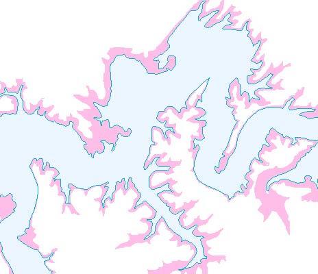
11 Case Study A: Isolate a single continuous centerline Pomme de Terre Missouri humid - hilly


12 Pomme de Terre MO NHD 24k humid - hilly Emphasized Problems Multiple centerlines in NHD polygons Distinguish primary and secondary centerlines Gaps in centerline continuity Submerged stream conflicts with centerline

13 Pomme de Terre MO NHD 24k humid - flat 3. Simplify flowlines 1. Select and simplify waterbodies and areas Prototype in ModelBuilder; test code in Python 2. Primary and secondary centerlines


14 1. Select and simplify NHD areas / waterbodies
15 2. Primary and secondary centerlines Intersect flowlines with selected polys; select on GNIS name; simplify CEGIS meeting, August 2009
16 Centerline continuity problems NHD Artificial Paths insufficient to produce cartographic centerlines gap gap CEGIS meeting, August 2009


17 3. Simplify flowlines CEGIS meeting, August 2009

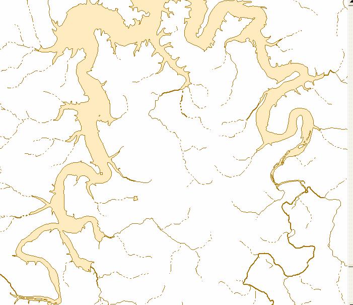
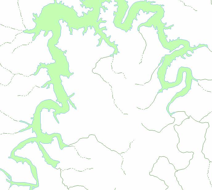
18 Draft result MO 50K LoD mapped at 100K With original 24K hydro With derived 50K hydro
19 Draft result MO 50K LoD mapped at 100K High resolution (24K) NHD Derived 50K LoD
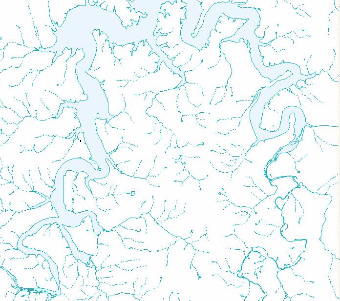
20 Validation Medium Resolution Derived 50K LoD (100K NHD)


21 Missouri Metrics channel length sum d km channel length /24k length channel density km / km2 NHD 24k 3, LoD 50k 1, NHD 100k 1, catchment area 24k 1, k 2,001 24k 50k 100k CEGIS meeting, August 2009

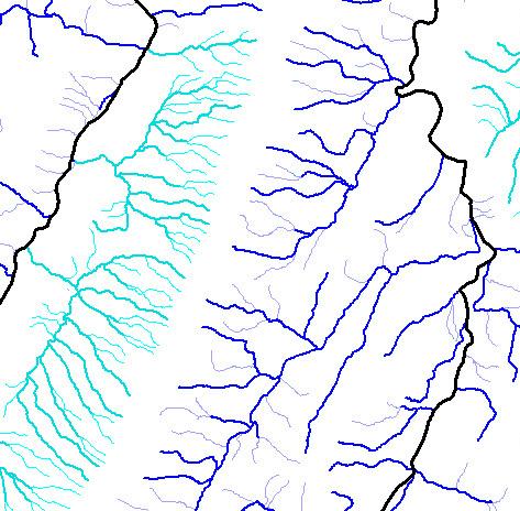
22 MO: Original 24K hydro compared to 50K LoD At 300K CEGIS meeting, August 2009
23 Case Study B: Identify NHD Flowlines by local density S. Branch Potomac River humid - mountainous

24 S. Branch Potomac W V NHD 24k humid - mountainous Objectives: Preserve local density Protect topology Formalize thresholds for pruning Retain pruned tributaries for mapping CEGIS meeting, August 2009


25 What is meant by local density CEGIS meeting, August 2009

26 Upper Potomac W V NHD 24k humid - mountainous 1. Prune differentially, merge, build diffs_file 3. Isolate non-centerline flowlines 4. Simplify 2. Intersect NHD flowlines with NHD areas / waterbodies to delineate centerlines

27 Prune differentially Selection of dense and non-dense networks (manual, at present) Pruning criterion: Summed remaining stream channel length Summed original catchment area
28 Formalize thresholds for pruning Pruning thresholds taken from Radical Law: # _ items = t arg et.# _ itemssource * RF source RF t arget Modified as follows: channel _length = t arg et channel _length source * RF source RF t arg et For WVA: target length = 6, km * SQRT(24k/50k) = 4, km

29 Radical Law worksheet Optimum pruning levels nor60: 2, den40: 1, ,
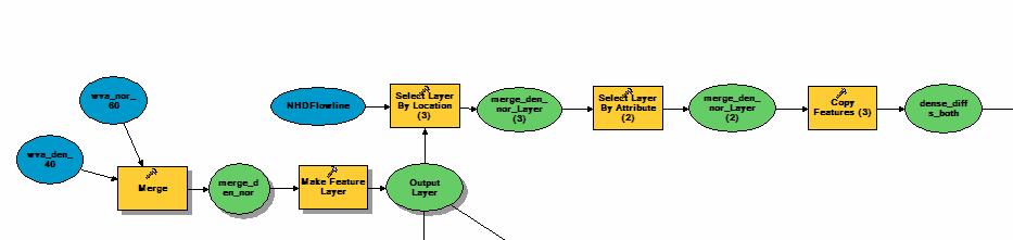

30 1. Prune differentially, merge, build diffs_file CEGIS meeting, August 2009

31 Draft result WV 50K LoD mapped At 100K: With original 24K hydro With derived 50K LoD

32 Draft result WV 50K LoD mapped At 100K: With original 24K hydro With derived 50K LoD
33 Draft result WV 50K LoD mapped At 100K: With original 24K hydro With derived 50K LoD

34 West Virginia Metrics channel length sum d km channel length /24k length channel density km / km2 NHD 24k 6, LoD 50k 2, NHD 100k 1, catchment area 24k 3, k 3,543 24k 50k 100k CEGIS meeting, August 2009
35 Summary Status of our Work Physiography and climate impact 3 aspects of generalization Tool sequencing, Algorithm choice, Parameter choice Status: 4 of 8 subbasin solutions prototyped and moved to Python scripts, enter refinement phase this fall Centerline continuity NHD Artificial Paths insufficient to produce cartographic centerlines still unsolved trace the node network? Selection of density classes for pruning experiment in Iowa subbasins to select density classes automatically, scaling up to national fix. Stanislawski, Buttenfield and Roth 2009; ICC paper for meetings in Santiago
36 Funding acknowledgements USGS Center of Excellence for Geospatial Information Science (CEGIS) Funded through Department of Interior CESU program, January 2007 to present Initial Generalization and ScaleMaster work funded by ESRI, June 2003 to May 2007
37 Metric Evaluation Other Examples of Metric Evaluation preserved channel length original channel length % length preserved preserved channel length (original) catchment area % density preserved symbol line weight (in ground units) * channel original LoD scale real estate utilized
Evaluating Generalizations of Hydrography in Differing Terrains for The National Map of the United States
 Evaluating Generalizations of Hydrography in Differing Terrains for The National Map of the United States Cynthia Brewer, Pennsylvania State University Barbara Buttenfield, University of Colorado Boulder
Multiple Representations of Geospatial Data: A Cartographic Search for the Holy Grail?
 Multiple Representations of Geospatial Data: A Cartographic Search for the Holy Grail? Barbara P. Buttenfield University of Colorado Boulder Research Faculty Affiliate, USGS-CEGIS babs@colorado.edu 13
Evaluation of Map Symbols by Screen Resolution and File Format Through Scale
 Evaluation of Map Symbols by Screen Resolution and File Format Through Scale Cynthia Brewer and Chelsea Hanchett, Penn State Barbara Buttenfield, Boulder Lawrence Stanislawski, CEGIS Penn State Research
Design for multiscale topographic mapping with minimal generalization
 Design for multiscale topographic mapping with minimal generalization Cynthia A. Brewer Department of Geography, Pennsylvania State University, University Park, PA, 16802, USA cbrewer@psu.edu Extended
Multiscale Representations of Water: Tailoring Generalization Sequences to Specific Physiographic Regimes
 Multiscale Representations of Water: Tailoring Generalization Sequences to Specific Physiographic Regimes Barbara P. Buttenfield 1, Lawrence V. Stanislawski 2, Cynthia A. Brewer 3 1 Department of Geography,
Performance of Map Symbol and Label Design with Format and Display Resolution Options Through Scale for The National Map
 Performance of Map Symbol and Label Design with Format and Display Resolution Options Through Scale for The National Map Follow-up on AutoCarto 2011 talk Cynthia A. Brewer, Pennsylvania State University
Performance of Map Symbol and Label Design with Format and Display Resolution Options Through Scale for The National Map
 Performance of Map Symbol and Label Design with Format and Display Resolution Options Through Scale for The National Map Cynthia A. Brewer, Pennsylvania State University Chelsea L. Hanchett, Penn State
Assessment of a Rapid Approach for Estimating Catchment Areas for Surface Drainage Lines
 Assessment of a Rapid Approach for Estimating Catchment Areas for Surface Drainage Lines U.S. Geological Survey Center of Excellence for Geospatial Information Science 1400 Independence Road, Rolla Missouri,
Hydrologically Consistent Pruning of the High- Resolution National Hydrography Dataset to 1:24,000-scale
 Hydrologically Consistent Pruning of the High- Resolution National Hydrography Dataset to 1:24,000-scale Lawrence V. Stanislawski 1, Ariel Doumbouya 2, Barbara P. Buttenfield 3, 1 Center for Excellence
Establishing Classification and Hierarchy in Populated Place Labeling for Multiscale Mapping for The National Map
 Establishing Classification and Hierarchy in Populated Place Labeling for Multiscale Mapping for The National Map Stephen Butzler, Cynthia Brewer and Jim Thatcher RA: Doug Minnigh Gould Center, Geography
Establishing Classification and Hierarchy in Populated Place Labeling for Multiscale Mapping for The National Map
 Establishing Classification and Hierarchy in Populated Place Labeling for Multiscale Mapping for The National Map Wesley Stroh, Stephen Butzler and Cynthia Brewer Gould Center, Geography Pennsylvania State
ScaleMaster characterization of types of design change through scale for mapping from multi-resolution databases
 ScaleMaster characterization of types of design change through scale for mapping from multi-resolution databases Cynthia A. Brewer, Pennsylvania State University Jessica Acosta, Penn State ESRI Barbara
Introduction. Background
 Multi-resolution Multi-scale Topographic Map Design: Toward a New Look for The National Map Cynthia A. Brewer and Mamata K. Akella ABSTRACT: The pilot study reported here examined the effects on map readability
National Hydrography Dataset (NHD) Update Project for US Forest Service Region 3
 Update Project for US Forest Service Region 3") National Hydrography Dataset (NHD) Update Project for US Forest Service Region 3 Allison Moncada California State University, Northridge February 2017 July 2017 Advisor: Joel Osuna Center for Geographical
National Hydrography Dataset (NHD) Update Project for US Forest Service Region 3 Allison Moncada California State University, Northridge February 2017 July 2017 Advisor: Joel Osuna Center for Geographical
Improvement of the National Hydrography Dataset for Parts of the Lower Colorado Region and Additional Areas of Importance to the DLCC
 Improvement of the National Hydrography Dataset for Parts of the Lower Colorado Region and Additional Areas of Importance to the DLCC Carlos Reyes-Andrade California State University, Northridge September
NATIONAL HYDROGRAPHY DATASET (NHD) UPDATE PROJECT FOR US FOREST SERVICE REGION 3
 UPDATE PROJECT FOR US FOREST SERVICE REGION 3") NATIONAL HYDROGRAPHY DATASET (NHD) UPDATE PROJECT FOR US FOREST SERVICE REGION 3 Allison Moncada California State University, Northridge February 2018 July 2018 Advisor: Joel Osuna Center for Geospatial
NATIONAL HYDROGRAPHY DATASET (NHD) UPDATE PROJECT FOR US FOREST SERVICE REGION 3 Allison Moncada California State University, Northridge February 2018 July 2018 Advisor: Joel Osuna Center for Geospatial
Multiple Representations of Geospatial Data: A Cartographic Search for the Holy Grail
 Multiple Representations of Geospatial Data: A Cartographic Search for the Holy Grail Barbara P. Buttenfield University of Colorado, Boulder babs@colorado.edu Collaboration with Cindy Brewer, Penn State
Proceedings - AutoCarto Columbus, Ohio, USA - September 16-18, 2012
 Automated Metric Assessment of Line Simplification in Humid Landscapes Lawrence V. Stanislawski 1, Paulo Raposo 2, Michael Howard 1, and Barbara P. Buttenfield 3 1 Center for Excellence in Geospatial Information
The National Hydrography Dataset in the Pacific Region. U.S. Department of the Interior U.S. Geological Survey
 The National Hydrography Dataset in the Pacific Region U.S. Department of the Interior U.S. Geological Survey The National Map The National Map is built on partnerships and standards The National Map consists
Lidar-derived Hydrography as a Source for the National Hydrography Dataset
 Lidar-derived Hydrography as a Source for the National Hydrography Dataset Lidar-Derived Hydrography, Bathymetry, and Topobathymetry in the National Hydrography Dataset and 3-Dimensional Elevation Program
Mastering Map Scale: Formalizing Guidelines for Multi-Scale Map Design
 Mastering Map Scale: Formalizing Guidelines for Multi-Scale Map Design Cynthia A. Brewer Pennsylvania State University Barbara P. Buttenfield University of Colorado Boulder a.k.a. Cindy and babs Collaborators
Stream Correction for Local Government GIS
 Stream Correction for Local Government GIS A Practical Guide and Introduction Nicholas McKenny Penn State Adviser: James O'Brien 1/16 Presentation Outline Existing Situation Solution, Goals, & Hopes Guide
Ladder versus star: Comparing two approaches for generalizing hydrologic flowline data across multiple scales. Kevin Ross
 Ladder versus star: Comparing two approaches for generalizing hydrologic flowline data across multiple scales Kevin Ross kevin.ross@psu.edu Paper for Seminar in Cartography: Multiscale Hydrography GEOG
Improvement of the National Hydrography Dataset for US Forest Service Region 3 in Cooperation with the National Forest Service
 Improvement of the National Hydrography Dataset for US Forest Service Region 3 in Cooperation with the National Forest Service Christian L. DeCasas California State University, Northridge November 7 th,
A GIS-based Approach to Watershed Analysis in Texas Author: Allison Guettner
 Texas A&M University Zachry Department of Civil Engineering CVEN 658 Civil Engineering Applications of GIS Instructor: Dr. Francisco Olivera A GIS-based Approach to Watershed Analysis in Texas Author:
Leveraging LiDAR for Statewide NHD Hydrography Projects. Susan Phelps, CFM, GISP
 Leveraging LiDAR for Statewide NHD Hydrography Projects Susan Phelps, CFM, GISP Mon, July 11 th, 2016 National Hydrography Dataset (NHD) Background Why Local-Res NHD? Drivers Include: Availability of accurate
software, just as word processors or databases are. GIS was originally developed and cartographic capabilities have been augmented by analysis tools.
 1. INTRODUCTION 1.1Background A GIS is a Geographic Information System, a software package for creating, viewing, and analyzing geographic information or spatial data. GIS is a class of software, just
Indiana GIS Local Resolution NHD Applications. Indiana State GIS Conference
 Indiana GIS Local Resolution NHD Applications Indiana State GIS Conference May 7, 2013 Agenda Topics I. Indiana s National Hydrography y Data II. Accessing NHD Data III. Demonstrations Using Local NHD
COMPARISON OF TOPOGRAPHIC MAP DESIGNS FOR OVERLAY ON ORTHOIMAGE BACKGROUNDS
 CO-475 COMPARISON OF TOPOGRAPHIC MAP DESIGNS FOR OVERLAY ON ORTHOIMAGE BACKGROUNDS RAPOSO P.J., BREWER C.A. Penn State University, STATE COLLEGE, UNITED STATES INTRODUCTION This paper reports the findings
StreamStats: Delivering Streamflow Information to the Public. By Kernell Ries
 StreamStats: Delivering Streamflow Information to the Public By Kernell Ries U.S. Department of the Interior U.S. Geological Survey MD-DE-DC District 410-238-4317 kries@usgs.gov StreamStats Web Application
USGS Hydrography Overview. May 9, 2018
 + 1 USGS Hydrography Overview May 9, 2018 + 2 The National Geospatial Program Provides the geospatial baseline of the Nation s topography, natural landscape and built environment through The National Map,
Height Above Nearest Drainage in Houston THE UNIVERSITY OF TEXAS AT AUSTIN
 Height Above Nearest Drainage in Houston THE UNIVERSITY OF TEXAS AT AUSTIN Jeff Yuanhe Zheng GIS in Water Resources December 2 nd, 2016 Table of Contents 1.0 Introduction... 1 2.0 Project Objective...
GRAPEVINE LAKE MODELING & WATERSHED CHARACTERISTICS
 GRAPEVINE LAKE MODELING & WATERSHED CHARACTERISTICS Photo Credit: Lake Grapevine Boat Ramps Nash Mock GIS in Water Resources Fall 2016 Table of Contents Figures and Tables... 2 Introduction... 3 Objectives...
Hydrography Webinar Series
 Hydrography Webinar Series Session 2 May 21, 2015 U.S. Department of the Interior U.S. Geological Survey U.S. GEOLOGICAL SURVEY HYDROGRAPHY WEBINAR SERIES Hosted by: Jeff Simley Al Rea Hydrography Webinar
ROAD SEDIMENT ASSESSMENT & MODELING: KOOTENAI-FISHER TMDL PLANNING AREA ROAD GIS LAYERS & SUMMARY STATISTICS
 ROAD SEDIMENT ASSESSMENT & MODELING: KOOTENAI-FISHER TMDL PLANNING AREA ROAD GIS LAYERS & SUMMARY STATISTICS Prepared by: ATKINS Water Resources Group 820 North Montana Avenue Helena, MT 59601 November
What is a Base Map? Barbara P. Buttenfield, CU-Boulder Cynthia A. Brewer, Penn State Charlie Frye and Aileen Buckley, ESRI
 What is a Base Map? Barbara P. Buttenfield, CU-Boulder Cynthia A. Brewer, Penn State Charlie Frye and Aileen Buckley, ESRI babs@colorado.edu, cbrewer@psu.edu, cfrye@esri.com, abuckley@esri.com 1 Funding
An Open Source Solution to High Performance Processing for Extracting Surface Water Drainage Networks from Diverse Terrain Conditions
 An Open Source Solution to High Performance Processing for Extracting Surface Water Drainage Networks from Diverse Terrain Conditions Lawrence V. Stanislawski, Kornelijus Survila, Jeffrey Wendel, Yan Liu,
Using GIS to Delineate Watersheds Ed Poyer NRS 509, Fall 2010
 Using GIS to Delineate Watersheds Ed Poyer NRS 509, Fall 2010 A watershed is an area that contributes flow to a point on the landscape. (Bolstad, 2005). Watersheds are an important focus of study because
Preparing a NFIE-Geo Database for Travis County
 Preparing a NFIE-Geo Database for Travis County By David R. Maidment Center for Research in Water Resources University of Texas at Austin 2 February 2015 Contents Introduction... 1 Step 1. Download and
Development and Land Use Change in the Central Potomac River Watershed. Rebecca Posa. GIS for Water Resources, Fall 2014 University of Texas
 Development and Land Use Change in the Central Potomac River Watershed Rebecca Posa GIS for Water Resources, Fall 2014 University of Texas December 5, 2014 Table of Contents I. Introduction and Motivation..4
DRAFT FOR REVIEW PURPOSES ONLY MEMORANDUM OF UNDERSTANDING BETWEEN THE DEPARTMENT OF THE INTERIOR U.S. GEOLOGICAL SURVEY AND
 MEMORANDUM OF UNDERSTANDING BETWEEN THE DEPARTMENT OF THE INTERIOR U.S. GEOLOGICAL SURVEY AND THE WEST VIRGINIA OFFICE OF GIS STATE COORDINATOR FOR THE STEWARDSHIP OF THE NATIONAL HYDROGRAPHY DATASET I.
Louisiana Transportation Engineering Conference. Monday, February 12, 2007
 Louisiana Transportation Engineering Conference Monday, February 12, 2007 Agenda Project Background Goal of EIS Why Use GIS? What is GIS? How used on this Project Other site selection tools I-69 Corridor
What's New with NHDPlus (Classic)?
?") What's New with NHDPlus (Classic)? 1987 Reach File Version 1 2017 - NHDPlus Annie Mejaes EPA, Office of Water 2 Overview NHD-NHDPlus Basics Evolving NHD-NHDPlus Data and Tools Training and Support The
What's New with NHDPlus (Classic)? 1987 Reach File Version 1 2017 - NHDPlus Annie Mejaes EPA, Office of Water 2 Overview NHD-NHDPlus Basics Evolving NHD-NHDPlus Data and Tools Training and Support The
ParkServe. The Trust for Public Land s. Emmalee Dolfi Gabriel Patterson-King ESRI User Conference 2017
 The Trust for Public Land s ParkServe Automating Large-Scale Data Transformation, QA/QC and Analysis Emmalee Dolfi Gabriel Patterson-King ESRI User Conference 2017 Our mission The Trust for Public Land
The production and use of a hydrographic flow-direction network of surface waters. Rickard HALLENGREN, Håkan OLSSON and Erik SISELL, Sweden
 The production and use of a hydrographic flow-direction network of surface waters Rickard HALLENGREN, Håkan OLSSON and Erik SISELL, Sweden Key words: hydrographic, flow-direction network, surface waters
Hydrology and Watershed Analysis
 Hydrology and Watershed Analysis Manual By: Elyse Maurer Reference Map Figure 1. This map provides context to the area of Washington State that is being focused on. The red outline indicates the boundary
Distinct landscape features with important biologic, hydrologic, geomorphic, and biogeochemical functions.
 1 Distinct landscape features with important biologic, hydrologic, geomorphic, and biogeochemical functions. Have distinguishing characteristics that include low slopes, well drained soils, intermittent
Geospatial Reference Information. Spanish Hydrography GRI product: Implementation of INSPIRE Directive in a reference theme Paloma Abad Power
 Geospatial Reference Information Spanish Hydrography GRI product: Implementation of INSPIRE Directive in a reference theme Paloma Abad Power Introduction NEED: It is necessary to develop GRI of hydrography
Lecture 3. Data Sources for GIS in Water Resources
 Lecture 3 Data Sources for GIS in Water Resources GIS in Water Resources Spring 2015 http://www.data.gov/ 1 USGS GIS data for Water http://water.usgs.gov/maps.html Watersheds of the US 2-digit water resource
4. GIS Implementation of the TxDOT Hydrology Extensions
 4. GIS Implementation of the TxDOT Hydrology Extensions A Geographic Information System (GIS) is a computer-assisted system for the capture, storage, retrieval, analysis and display of spatial data. It
Base Level Engineering FEMA Region 6
 Base Level Engineering Over the past five years, has been evaluating its investment approach and data preparation work flow to establish an efficient and effective change in operation, generating an approach
Multiple Representations with Overrides, and their relationship to DLM/DCM Generalization. Paul Hardy Dan Lee
 Multiple Representations with Overrides, and their relationship to DLM/DCM Generalization Paul Hardy Dan Lee phardy@esri.com dlee@esri.com 1 Context This is a forward-looking presentation, and much of
GIS in Water Resources Exercise #4 Solution
 GIS in Water Resources Exercise #4 Solution 1. Table giving the length of the Logan River main stream from NHDPlus Length (km) column, Landscape.gdb\NHDPlusv shape_length and Logan.gdb\Basemap\LoganMain
What s New in Topographic Information - USGS National Map
 + What s New in Topographic Information - USGS National Map SARGIS Workshop November 14, 2016 Rob Dollison, 703-648-5724 rdollison@usgs.gov + USGS 2 National Geospatial Program The National Geospatial
A Comparison of Manual and Computer-Assisted Drainage Delineation Methods for Hydrologic-Unit Map Development
 This paper was peer-reviewed for scientific content. Pages 1118-1127. In: D.E. Stott, R.H. Mohtar and G.C. Steinhardt (eds). 2001. Sustaining the Global Farm. Selected papers from the 10th International
Chapter 6 Mapping and Online Tools
 Chapter 6 Mapping and Online Tools The stream site you monitor is just part of a much larger system. When analyzing stream health, it is important to take a holistic view by considering the entire watershed.
USGS National Hydrography Dataset (NHD) and NHDPlus
 and NHDPlus") + 1 + USGS National Hydrography Dataset (NHD) and NHDPlus Al Rea USGS National Geospatial Program Western States Water Council August 1, 2018 + 2 USGS National Hydrography Datasets Hydrologic networks,
+ 1 + USGS National Hydrography Dataset (NHD) and NHDPlus Al Rea USGS National Geospatial Program Western States Water Council August 1, 2018 + 2 USGS National Hydrography Datasets Hydrologic networks,
An Information Model for Maps: Towards Cartographic Production from GIS Databases
 An Information Model for s: Towards Cartographic Production from GIS Databases Aileen Buckley, Ph.D. and Charlie Frye Senior Cartographic Researchers, ESRI Barbara Buttenfield, Ph.D. Professor, University
Watershed Modeling With DEMs
 Watershed Modeling With DEMs Lesson 6 6-1 Objectives Use DEMs for watershed delineation. Explain the relationship between DEMs and feature objects. Use WMS to compute geometric basin data from a delineated
State of Israel Ministry of Housing and Construction Survey of Israel. The Hydrological project case
 State of Israel Ministry of Housing and Construction Survey of Israel The Hydrological project case Survey of Israel Content Introduction To the Survey of Israel The operation assumptions The main responsibilities
AUTOMATING GENERALIZATION TOOLS AND MODELS
 AUTOMATING GENERALIZATION TOOLS AND MODELS Dan Lee and Paul Hardy ESRI, Inc. 380 New York St., Redlands CA 92373, USA Telephone: (909) 793-2853; Fax: (909) 793-5953 E-mail: dlee@esri.com; phardy@esri.com
Cartography: Modeling GIS data for Mapmaking. Aileen Buckley, Ph.D. Senior Cartographic Researcher, ESRI. Barbara Buttenfield, Ph.D.
 Slide 1 Cartography: Modeling GIS data for Mapmaking Aileen Buckley, Ph.D. Senior Cartographic Researcher, ESRI Barbara Buttenfield, Ph.D. Professor, University of Colorado-Boulder Thank you coming to
Proceedings - AutoCarto Columbus, Ohio, USA - September 16-18, Effects of Iterative Spatial Filtering on DEM Data Structure
 Effects of Iterative Spatial Filtering on DEM Data Structure Andrew J. Stauffer 1, Barbara P. Buttenfield 1, and Lawrence V. Stanislawski 2 1 Department of Geography, University of Colorado, Boulder, Colorado
Mapping Undersea Feature Names in S-100. UFNPT at SCUFN 31 Wellington, New Zealand October, 2018
 Mapping Undersea Feature Names in S-100 UFNPT at SCUFN 31 Wellington, New Zealand October, 2018 Content - Update about UFNPT - Discovery of Undersea Features - excercise Work Plan of the UFNPT November
UNIVERSITY OF CAMBRIDGE INTERNATIONAL EXAMINATIONS General Certifi cate of Education Advanced Subsidiary Level and Advanced Level
 UNIVERSITY OF CAMBRIDGE INTERNATIONAL EXAMINATIONS General Certifi cate of Education Advanced Subsidiary Level and Advanced Level *7041204919* GEOGRAPHY 9696/11 Paper 1 Core Geography October/November
Design and Development of Linked Data from The National Map. E. Lynn Usery and Dalia Varanka.
 Design and Development of Linked Data from The National Map E. Lynn Usery and Dalia Varanka usery@usgs.gov; dvaranka@usgs.gov Abstract The development of linked data on the World-Wide Web provides the
Streams in the Ranching Country of South Texas
 Streams in the Ranching Country of South Texas Watershed Analysis of HUC 12110207 Sandranell Moerbe CE GIS in Water Resources Fall 2015 INTRODUCTION This project investigates the portion of South Texas
Within this document, the term NHDPlus is used when referring to NHDPlus Version 2.1 (unless otherwise noted).
.") Exercise 7 Watershed Delineation Using ArcGIS Spatial Analyst Last Updated 4/6/2017 Within this document, the term NHDPlus is used when referring to NHDPlus Version 2.1 (unless otherwise noted). There
Exercise 7 Watershed Delineation Using ArcGIS Spatial Analyst Last Updated 4/6/2017 Within this document, the term NHDPlus is used when referring to NHDPlus Version 2.1 (unless otherwise noted). There
IDENTIFYING VECTOR FEATURE TEXTURES USING FUZZY SETS
 IDENTIFYING VECTOR FEATURE TEXTURES USING FUZZY SETS C. Anderson-Tarver a, S. Leyk a, B. Buttenfield a a Dept. of Geography, University of Colorado-Boulder, Guggenheim 110, 260 UCB Boulder, Colorado 80309-0260,
NWT Open Report Delineation of Watersheds in the Mackenzie Mountains
 NWT Open Report 2015-007 Delineation of Watersheds in the Mackenzie Mountains K.L. Pierce and H. Falck Recommended Citation: Pierce, K.L. and Falck, H., 2015. Delineation of watersheds in the Mackenzie
Thesis: Citizen Science Land Cover Classification Based on Ground and Aerial Imagery B.Sc. in Geography The Pennsylvania State University
 Kevin Sparks sparksk16@gmail.com kevinsparks.io summer, 2017 Education 2013 2015 M.S. in Geography The Pennsylvania State University Thesis: Citizen Science Land Cover Classification Based on Ground and
CLUSTERING APPROACHES FOR HYDROGRAPHIC GENERALIZATION. Alper SEN, Turkay GOKGOZ
 CLUSTERING APPROACHES FOR HYDROGRAPHIC GENERALIZATION Alper SEN, Turkay GOKGOZ Geomatics Engineering Department, Civil Engineering Faculty, Yildiz Technical University, Davutpasa Street, 34220, Esenler,
Development of Riparian Maps for Sonoma County Long Term Riparian Corridor Conservation. Mark Tukman & Dylan Loudon Tukman Geospatial
 L A N D F O R Development of Riparian Maps for Sonoma County Long Term Riparian Corridor Conservation Mark Tukman & Dylan Loudon Tukman Geospatial L I F E Mark Background on functional riparian mapping
Recommendations for installation and general overview of available tools
 User guide for FluvialCorridor toolbox Recommendations for installation and general overview of available tools How to cite : Roux., C., Alber, A., Bertrand, M., Vaudor, L., Piégay, H., 2013. General Overview
Statewide wetland geospatial inventory update
 Statewide wetland geospatial inventory update Factsheet 1: Outcomes from the statewide wetland geospatial inventory update 1 Introduction In 2011 the Victorian Department of Environment and Primary Industries
A New Automated Approach To Sewershed Delineation For Urban Drainage Modelling Studies: A City Of Toronto Case Study
 City University of New York (CUNY) CUNY Academic Works International Conference on Hydroinformatics 8-1-2014 A New Automated Approach To Sewershed Delineation For Urban Drainage Modelling Studies: A City
Georeferencing Water Quality Assessments to NHDPlus Catchments
 Georeferencing Water Quality Assessments to NHDPlus Catchments A New Approach to Evaluating and Measuring Progress in Surface Water Quality DWANE YOUNG, U.S. EPA, OFFICE OF WATER Outline Georeferencing
Delineation of high landslide risk areas as a result of land cover, slope, and geology in San Mateo County, California
 Delineation of high landslide risk areas as a result of land cover, slope, and geology in San Mateo County, California Introduction Problem Overview This project attempts to delineate the high-risk areas
A Help Guide for Using gssurgo to Find Potential Wetland Soil Landscapes
 A Help Guide for Using gssurgo to Find Potential Wetland Soil Landscapes Wetland Mapping Consortium Webinar September 17, 2014 Dr. John M. Galbraith Crop & Soil Environmental Sciences Virginia Tech Wetland
8 th 12 th Designing a Monitoring Plan Mapping & Analysis (Activities 1 2)
") 8 th 12 th Designing a Monitoring Plan Mapping & Analysis (Activities 1 2) Objectives for All Activities - To be able to define and describe the purpose and uses of topographic maps. - To define rules
8 th 12 th Designing a Monitoring Plan Mapping & Analysis (Activities 1 2) Objectives for All Activities - To be able to define and describe the purpose and uses of topographic maps. - To define rules
A Simple Drainage Enforcement Procedure for Estimating Catchment Area Using DEM Data
 A Simple Drainage Enforcement Procedure for Estimating Catchment Area Using DEM Data David Nagel, John M. Buffington, and Charles Luce U.S. Forest Service, Rocky Mountain Research Station Boise Aquatic
Characterization of Catchments Extracted From. Multiscale Digital Elevation Models
 Applied Mathematical Sciences, Vol. 1, 2007, no. 20, 963-974 Characterization of Catchments Extracted From Multiscale Digital Elevation Models S. Dinesh Science and Technology Research Institute for Defence
Subject: Geography Unit 1: The Earth
 Subject: Geography Unit 1: The Earth Learning outcomes Activities Resources Thinking Skills Language of Learning The earth s relief and its different forms such as mountains, valleys, plains. The parts
Designing GIS Databases to Support Mapping and Map Production Charlie Frye, ESRI Redlands Aileen Buckley, ESRI Redlands
 Designing GIS Databases to Support Mapping and Map Production Charlie Frye, ESRI Redlands Aileen Buckley, ESRI Redlands 1 Designing GIS Databases to Support Mapping and Map Production Charlie Frye, ESRI
Rick Faber CE 513 Watershed and Streamwork Delineation Lab # 3 4/24/2006
 Rick Faber CE 513 Watershed and Streamwork Delineation Lab # 3 4/24/2006 1. Objective & Discussion: 2 To learn to use the ArcHydro tools to produce hydrologically descriptive data sets starting from a
Management and Sharing of Hydrologic Information of Cache County
 Geographic Information System in Water Resources CEE6440 Fall Semester 2012 Management and Sharing of Hydrologic Information of Cache County To: Dr. David Tarboton Instructor By: Tian Gan Dec.7, 2012 I.
Delineation of Watersheds
 Delineation of Watersheds Adirondack Park, New York by Introduction Problem Watershed boundaries are increasingly being used in land and water management, separating the direction of water flow such that
Aileen Buckley, Ph.D. and Charlie Frye
 An Information Model for Maps: Towards Production from GIS Databases Aileen Buckley, Ph.D. and Charlie Frye Researchers, ESRI GIS vs. cart GIS Outline of the presentation Introduction Differences between
Exploring representational issues in the visualisation of geographical phenomenon over large changes in scale.
 Institute of Geography Online Paper Series: GEO-017 Exploring representational issues in the visualisation of geographical phenomenon over large changes in scale. William Mackaness & Omair Chaudhry Institute
NAME DATE TOPOGRAPHIC MAPS. Activity 1: Topographic Map Investigation I: More Than a Road Map
 NAME DATE PARTNER(S) TOPOGRAPHIC MAPS Now you have seen how topographic maps can be generated to present the elevation of a terrain. Let s look at some topographic maps and learn how to interpret them.
Workshop: Build a Basic HEC-HMS Model from Scratch
 Workshop: Build a Basic HEC-HMS Model from Scratch This workshop is designed to help new users of HEC-HMS learn how to apply the software. Not all the capabilities in HEC-HMS are demonstrated in the workshop
Drainage Area: GL, VPU: 04 - Release Notes. 12/01/2018 Updated and New Data
 Drainage Area: GL, VPU: 04 - Release Notes 12/01/2018 Updated and New Data Time of Travel and Related Attributes: The new and updated data is included in new versions of the NHDPlusAttributes and EROMExtension
European River Catchment Updates: Iceland, Malta and Romania
 Final Draft Working Document European River Catchment Updates: Iceland, Malta and Romania Prepared by: Alejandro IGLESIAS-CAMPOS ETC-LUSI / Junta de Andalucía 11.01.2008 Version 2 Project manager: Ana
P. WILLIAM LIMPISATHIAN FEBRUARY 4, 2017
 P. WILLIAM LIMPISATHIAN FEBRUARY 4, 2017 302 Walker Building, University Park, PA 16802 330-322-5435 bill1@psu.edu sites.psu.edu/bill EDUCATION The Pennsylvania State University University Park, PA M.S.
LRS Task Force June 13, REVISION HISTORY
 North Carolina Department of Transportation Geographic Information Systems (GIS) Unit LINEAR REFERENCING SYSTEM (LRS) PROJECT DEFINITION Version 1.0 REVISION HISTORY Date Document Manager Revision Purpose
Cynthia Ann Brewer Curriculum Vitae, January 2018 EMPLOYMENT EDUCATION
 Cynthia Ann Brewer Curriculum Vitae, January 2018 Department of Geography (814) 865-5072 302 Walker Building cbrewer@psu.edu The Pennsylvania State University @ColorBrewer University Park, PA 16802 www.geog.psu.edu/people/brewer-cynthia
Elevations are in meters above mean sea level. Scale 1:2000
 12.001 LAB 7: TOPOGRAPHIC MAPS Due: Monday, April 11 PART I: CONTOURING AND PROFILES (20 PTS) 1. Contour this area map using a 5 meter contour interval. Remember some fundamental rules of contour lines,
The improvement of production of the GDR50LT in Lithuania
 The improvement of production of the in Lithuania Kęstutis PAPŠYS, Lina PAPŠIENĖ, Julius D. BUDREVIČIUS, Marius MARMA, Evaldas ROŽANSKAS, Mindaugas PAŽEMYS / GIS-Centras Jurgita ŠPŪRAITĖ / National Land
Urban Erosion Potential Risk Mapping with GIS
 Urban Erosion Potential Risk Mapping with GIS ESRI Water Conference San Diego, CA Jan 29-Feb 1, 2018 Dr. Randy Dymond, PE, F.ASCE, D.WRE Co-investigators: Amanda Weikmann, MS Student Dr. Clay Hodges, PE
Generalized map production: Italian experiences
 Generalized map production: Italian experiences FIG Working Week 2012 Knowing to manage the territory, protect the environment, evaluate the cultural heritage Rome, Italy, 6-10 May 2012 Gabriele GARNERO,