The Restoration Process from the Great East Japan Earthquake, and Perspectives for the Sustainable Society by Creating Cultural Landscapes
|
|
|
- Blake Leonard
- 5 years ago
- Views:
Transcription
1 Session 3 Restoration from the Huge Natural Disasters, and Creating Cultural Landscapes for the Sustainable Society The Restoration Process from the Great East Japan Earthquake, and Perspectives for the Sustainable Society by Creating Cultural Landscapes Jan. 18, 2013 Mikiko Ishikawa Professor of Dept. of Urban Engineering, The University of Tokyo


2 Great East Japan Earthquake Great East Japan Earthquake Date: March dead 15,870 missing 2,814 Completely destroyed Houses 130,000 Partially destroyed Houses 265,000 Radiation Accident Fukushima Many traditional Local Communities
3 Sustainability 1.Environmental Sustainability 2.Social Sustainability 3.Cultural Sustainability
4 1. Characteristics of the Region <Environmental Aspect> Three different regions Rias Coastal Zone Alluvial Flat Zone Fukushima


5 Rias Coastal Zone Rikuzen-Takada City Kesen-numa City The hight of Tsunmi meter Tsunami Edge
")
")
6 Meiji Sanriku Tsunami (1896) Syowa Sanriku Tsunami (1928)


7 Alluvial Flats Area Southern Sendai City Few Experiences about Tsunami. No high Areas to escape. This is the first time to propose the restoration plan.

 1910 s : Pond")

8 Original Landforms emerged again, after the earthquake (Hasegama Village) 1910 s : Pond 2010 : Rice Field After Earthquake turned into pond, again
9 < Social Aspect > Decreasing Population Increasing of Elderly People

10 Decreasing Population

11 Increasing of Elderly people
12 < Cultural Aspect > Spiritual Places had survived (Tangible, Intangible) Ties of Community has succeeded (Social Capital)
")


13 Hiyoriyama Fisherman s Hill (Yuriage, Natori City) There are many Hiyoriyama in all over Tohoku Region. Monument built after Syowa Sanriku Tsunami in It said, when the earthquake occurs, be aware of the tsunami.


14 Jizo (Buddhist Bodhisattvas)


15 Tiny Shrine in each House : jinai-myojin Sustainable Devices Sustainable Devices Jinai-myojin 地内明神
16 2. Restoration Process
17 Planning Process Each Local Municipality made own restoration plan with the help from Pref. government and National government. This policy was highly based on the principal of the decentralization of national government power. Good Effect: Reflect the needs of local community Problem: Lack of Regional Consideration


 58 19 276 82 0")
18 Number of Restoration Projects Comparison between Hanshin-Awaji and East Japan Damage of Buildings 約 100,000 約 140,000 約 130,000 約 265,000 Number of the Restoration 20 Projects 20 VS , , , , , , , , ,000 ( 戸数 ) ( 地区 18 )


19 The Method of the Restoration in Rias Coastal Zone Relocation residential estate Before Tsunami Flood Regions Reconstruction leveling

20 Restoration Plan of Minam-Sanriku Decreasing population

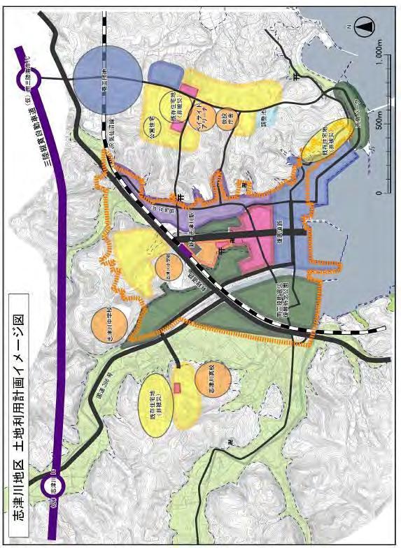

21 Problem lies in the Social Sustainability 28 Communities Remove to the higher land
22 3. Issues of the Restoration for Sustainable City and Regions 1 Where to live? Environmental Sustainability 2 Who decide and implement? Social Sustainability 3 What and when is the Target of the Restoration? Cultural Sustainability


23 Issue 1 : Environmental Sustainability To set up Land Use Principals Based on the Scientific Research, the Principal of Land Use should be established Watershed Management Relation between Forest, river and ocean Risk Management Sea tsunami & mountain Tsunami


24 Land Use Principals in Alluvial Flat Area Micro Geography is essential for weakening the power of Tsunami Identify the landscape unit for the principals of land use plan


25 Identify the Landscape Unit Geography Soil Vegetation

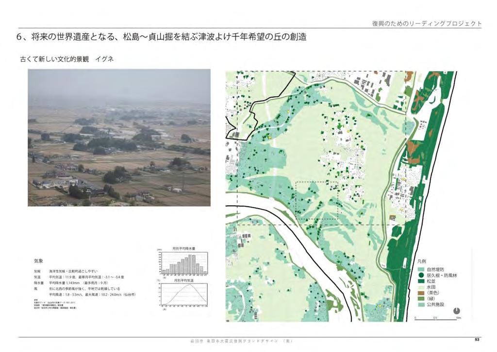
26 Principals of Land Use Plan
Tsunami. Harry Yeh Oregon State University. Eastern Japan Earthquake Disaster Briefing at PEER: April 28, 2011
 Tsunami by Harry Yeh Oregon State University Eastern Japan Earthquake Disaster Briefing at PEER: April 28, 2011 Seismic Characteristics Rupture Model (Harvard Seismology) The fault rupture process was
at IHO IRCC7 Mexico City, Mexico, June 2015
 Report on Japan s Response to Disasters presented by JHOD at IHO IRCC7 Mexico City, Mexico, 01 03 June 2015 JAPAN COAST GUARD Actions against huge earthquake Actions taken by JHOD against the Great East
Individual Self-help Housing Reconstruction with Relocation: Transformation of Built Environment after the Great East Japan Earthquake
 Individual Self-help Housing Reconstruction with Relocation: Transformation of Built Environment after the Great East Japan Earthquake Tamiyo Kondo, Kobe University tamiyok@people.kobe-u.ac.jp Yuka Karatani,
Risk-based land use and spatial planning
 Risk-based land use and spatial planning Miho OHARA International Centre for Water Hazards and Risk Management (ICHARM) Public Works Research Institute PWRI), Japan Under the auspices of UNESCO Introduction
Features of Tsunami height according to type of coastal landforms 2011 Tohoku oki tsunami case
 Features of Tsunami height according to type of coastal landforms 2011 Tohoku oki tsunami case (70 Nobuhisa Matta (Disaster Mitigation Research Center Nagoya Univ.) July 3 rd, 2013, at Taipei Outline +
Revival from Earthquake Disaster and Asbestos Problems
 Journal of Policy Science Vol.6 Revival from Earthquake Disaster and Asbestos Problems ISHIHARA Kazuhiko 1. Introduction Asbestos are used mostly in building materials, for instance sprayed asbestos, cement
What Are Disasters? The Rescue Kids Trio!
 The Rescue Kids Trio! What Are Disasters? This manual was made possible through funding by the Council of Local Authorities for International Relations. Disasters and emergency preparedness Emergency preparedness
ANALYSIS OF EVACUATION BEHAVIORS IN DIFFERENT AREAS BEFORE AND AFTER THE GREAT EAST JAPAN EARTHQUAKE
 Fifth International Conference on Geotechnique, Construction Materials and Environment, Osaka, Japan, Nov. 16-18, 2015, ISBN: 978-4-9905958-4-5 C3051 ANALYSIS OF EVACUATION BEHAVIORS IN DIFFERENT AREAS
KNOWLEDGE NOTE 5-1. Risk Assessment and Hazard Mapping. CLUSTER 5: Hazard and Risk Information and Decision Making. Public Disclosure Authorized
 Public Disclosure Authorized Public Disclosure Authorized Public Disclosure Authorized Public Disclosure Authorized KNOWLEDGE NOTE 5-1 CLUSTER 5: Hazard and Risk Information and Decision Making Risk Assessment
MEADOWS PRIMARY SCHOOL and NURSERY GEOGRAPHY POLICY
 MEADOWS PRIMARY SCHOOL and NURSERY GEOGRAPHY POLICY Purpose of study The teaching of Geography at Meadows is done by following the 2014 National Curriculum. The planning and teaching of the subject aims
Geography Education Challenges Regarding Disaster Mitigation in Japan
 Geography Education Challenges Regarding Disaster Mitigation in Japan Koji OHNISHI 1 University of Toyama, Toyama, JAPAN Hiroshi MITSUHASHI 2 Ministry of Education, Culture, Sports, Science & Technology,
Word Cards. 2 map. 1 geographic representation. a description or portrayal of the Earth or parts of the Earth. a visual representation of an area
 Name: Date: Hour: Word Cards 1 geographic representation a description or portrayal of the Earth or parts of the Earth Example: A map is a representation of an actual location or place. 2 map a visual
HOLY CROSS CATHOLIC PRIMARY SCHOOL
 HOLY CROSS CATHOLIC PRIMARY SCHOOL Geography Policy Date Implemented Jan 17 Review Date Jan 22 Mission Statement Holy Cross Primary School is a Catholic School. We seek to provide a broad, balanced Christian
St John s Catholic Primary School. Geography Policy. Mission Statement
 St John s Catholic Primary School Geography Policy Mission Statement We at St John s strive for excellence in education by providing a safe, secure and caring family environment where individuals are valued
About places and/or important events Landmarks Maps How the land is, hills or flat or mountain range Connected to maps World Different countries
 What do you think you know about geography? About places and/or important events Landmarks Maps How the land is, hills or flat or mountain range Connected to maps World Different countries What do you
Physical Geography of East Asia
 Physical Geography of East Asia Satellite View of China Landforms of China China s Geography China Miles 0 250 500 1,000 1,500 2,000 United States 3 rd largest country in the world. Comparable to the US
Tuition, Medical and Behaviour Support Service
 Tuition, Medical and Behaviour Support Service Curriculum Policy - Primary Geography Reviewed: October 2018 Next Review: October 2019 Responsibility: Andrea Snow AIMS AND PRINCIPLES The national curriculum
The 2011 Tohoku earthquake and dams
 The 2011 Tohoku earthquake and dams N. Matsumoto & T. Sasaki Japan Dam Engineering Center, Japan T. Ohmachi Tokyo Institute of Technology, Japan ABSTRACT: The magnitude 9.0 Tohoku earthquake occurred on
EVACUATION, POST-DISASTER RECONSTRUCTION AND IMPROVEMENT MANAGEMENT FROM QOL STANDARDS IN DISASTERS
 EVACUATION, POST-DISASTER RECONSTRUCTION AND IMPROVEMENT MANAGEMENT FROM QOL STANDARDS IN DISASTERS TOGAWA Takuya*,, MIMURO Aoto*,, KATO Hirokazu*, HAYASHI Yoshitsugu*,, NISHINO Satoshi*,, TAKANO Tsuyoshi*
Social Vulnerability in Metro Manila: Implications for Preparedness and Response "
 Social Vulnerability in Metro Manila: Implications for Preparedness and Response " Earthquake Resilience Conference: Collaboration and Coordination in Preparedness and Response" 20-21 May 2015" Antonia
"The Big One" by sea and not by land
 "The Big One" by sea and not by land By Los Angeles Times, adapted by Newsela staff on 03.24.14 Word Count 629 Surfer Lee Johnson emerges from the water at San Onofre State Beach, Calif., with the twin
Final Presentation on Disaster Risk Management in Japan. Through ADRC V. R Programme. Main Findings and Action Plan:
 Final Presentation on Disaster Risk Management in Japan Through ADRC V. R Programme Main Findings and Action Plan: Problem/Hazard and Disaster in Japan Good Practiced on Disaster Risk Management in Japan
Disaster RISK Management : Bhutanese Scenario
 Disaster RISK Management : Bhutanese Scenario Expert Group Meeting (EGM) on Geo-referenced Information Systems for Disaster Risk Management (Geo-DRM) and sustaining the Community of Practice (COP), Bangkok,
Cranford Park CE Primary School. Subject Overview for Geography. Autumn 1 Autumn 2 Spring 1 Spring 2 Summer 1 Summer 2 Title of unit.
 Autumn 1 Autumn 2 Spring 1 Spring 2 Summer 1 Summer 2 Main Objectives /Skills Main Objectives /Skills Main Objectives /Skills Main Objectives /Skills Main Objectives /Skills Main Objectives /Skills Foundation
Natural Disaster and Coastal Geomorphology
 Natural Disaster and Coastal Geomorphology Shigeko Haruyama Toshihiko Sugai Editors Natural Disaster and Coastal Geomorphology 123 Editors Shigeko Haruyama Mie University Tsu Japan Toshihiko Sugai The
GEOGRAPHY POLICY. Date: March Signed: Review: March 2019
 GEOGRAPHY POLICY Date: March 2018 Signed: Review: March 2019 Aims At Hayton C of E Primary School we believe that Geography is an essential part of the curriculum and teachers ensure that the children
THE 2011 TOHOKU EARTHQUAKE IN JAPAN. VSU Lyuben Karavelov, Sofia, Bulgaria. Key words: Tohoku earthquake, strong ground motion, damage
 THE 2011 TOHOKU EARTHQUAKE IN JAPAN Radan Ivanov 1 VSU Lyuben Karavelov, Sofia, Bulgaria Abstract: This earthquake which occurred on March 11, 2011, had a magnitude of 9.0, which places it as the fourth
Earthquake Hazards. Tsunami
 Earthquake Hazards Tsunami Review: What is an earthquake? Earthquake is the vibration (shaking) and/or displacement of the ground produced by the sudden release of energy. The point inside the Earth where
Year 1 name and locate the four countries and capital cities of the United Kingdom and its surrounding seas
 Long Term Objective Organisation for Geography Please note that only statutory requirements should be included in this document; any supplementary guidance and information should be retained by Subject
Introduction to Environmental Geology, 5e Case History: Indonesian Tsunami Indonesian Tsunami (2) Introduction Historic Tsunamis
 Introduction Historic Tsunamis") 1 2 3 4 5 6 7 8 9 Introduction to Environmental Geology, 5e Chapter 7 Tsunami Case History: Indonesian Tsunami December 26, 2004, within a few hours, close to 250,000 people were killed With no warning
1 2 3 4 5 6 7 8 9 Introduction to Environmental Geology, 5e Chapter 7 Tsunami Case History: Indonesian Tsunami December 26, 2004, within a few hours, close to 250,000 people were killed With no warning
Proposing Effective Method to Develop Common Operational Picture in Disaster Response Utilizing Cloud-based Geospatial Infrastructure
 Proposing Effective Method to Develop Common Operational Picture in Disaster Response Utilizing Cloud-based Geospatial Infrastructure Munenari Inoguchi Research Institute for Natural Hazard & Disaster
Geography Progression
 Geography Progression This document aims to track expectations for History within George Grenville Academy. What the National Curriculum says: KS1: Locational Knowledge: Name and locate the world s 7 continents
Study of the liquefaction phenomenon due to an earthquake: case study of Urayasu city
 Disaster Management and Human Health Risk III 311 Study of the liquefaction phenomenon due to an earthquake: case study of Urayasu city S. Kamao 1, M. Takezawa 1, K. Yamada 1, S. Jinno 1, T. Shinoda 1
Report. Developing a course component on disaster management
 Report Developing a course component on disaster management By Chira Prangkio Tawee Chaipimonplin Department of Geography, Faculty of Social Sciences, Chiang Mai University Thailand Presented at Indian
New National Curriculum Geography Skills Planning KS1
 New National Curriculum Geography Skills Planning KS1 Enquiry Question Objective-essential knowledge skills or understanding Locational Knowledge Standards /Success Criteria Lesson progression over half
GEOGRAPHY POLICY STATEMENT. The study of geography helps our pupils to make sense of the world around them.
 GEOGRAPHY POLICY STATEMENT We believe that the study of geography is concerned with people, place, space and the environment and explores the relationships between the earth and its peoples. The study
Geography Long Term Plan
 Geography Long Term Plan Year Group Children should be taught about: The topic this will be based on: Essential Learning Objectives: (Taken from Chris Quigley) Year 1 Name and locate the world s seven
Landscape evolution. An Anthropic landscape is the landscape modified by humans for their activities and life
 Landforms Landscape evolution A Natural landscape is the original landscape that exists before it is acted upon by human culture. An Anthropic landscape is the landscape modified by humans for their activities
Geography Long Term Plan 2018
 Geography Long Term Plan 2018 Geography Co-ordinator: Megan Frost A high-quality geography education should inspire in pupils a curiosity and fascination about the world and its people that will remain
REPORT ON THE TOHOKU AREA PASIFIC OFFSHORE EARTHQUAKE
 REPORT ON THE TOHOKU AREA PASIFIC OFFSHORE EARTHQUAKE GENERAL PERSPECTIVE The Highest Magnitude Ever Recorded The 2011 off the Pacific Coast of Tohoku Earthquake (hereafter, the 2011 Tohoku- Pacific Earthquake
Earthquake Hazards. Tsunami
 Earthquake Hazards Tsunami Measuring Earthquakes Two measurements that describe the power or strength of an earthquake are: Intensity a measure of the degree of earthquake shaking at a given locale based
Flash flood disaster in Bayangol district, Ulaanbaatar
 Flash flood disaster in Bayangol district, Ulaanbaatar Advanced Training Workshop on Reservoir Sedimentation Management 10-16 October 2007. IRTCES, Beijing China Janchivdorj.L, Institute of Geoecology,MAS
RESIDENTIAL DAMAGE IN IBARAKI DURING THE GREAT EASTERN JAPAN EARTHQUAKE
 Proceedings of the International Symposium on Engineering Lessons Learned from the 2011 Great East Japan Earthquake, March 1-4, 2012, Tokyo, Japan RESIDENTIAL DAMAGE IN IBARAKI DURING THE GREAT EASTERN
Coseismic slip model
 Figure 3 - Preliminary highly smoothed model of coseismic slip for the 11 March UCL Institute for Risk & Disaster Reduction Magnitude 9.0 (JMA scale) earthquake Occurred at 02:46:23 pm local time near
ESTIMATION OF LANDFORM CLASSIFICATION BASED ON LAND USE AND ITS CHANGE - Use of Object-based Classification and Altitude Data -
 ESTIMATION OF LANDFORM CLASSIFICATION BASED ON LAND USE AND ITS CHANGE - Use of Object-based Classification and Altitude Data - Shoichi NAKAI 1 and Jaegyu BAE 2 1 Professor, Chiba University, Chiba, Japan.
EXECUTIVE SUMMARY. The title of this dissertation is Quantitative Study on Natural Disasters Risk
 1 EXECUTIVE SUMMARY The title of this dissertation is Quantitative Study on Natural Disasters Risk Management Policy Applying Statistical Data Analysis and Mathematical Modeling Approach. This research
Complete Geography Overview: Year 1 to Year 6
 Option 1 Complete Geography Overview: Year 1 to Year 6 Autumn Term Spring Term Summer Term Year 1 Where do I live? Around the World The Four Seasons Year 2 At the Farm Let s go on Safari My World and Me
Prevention Tsunami wall 10m high (breached by the tsunami due to land level falling by 3m)
") Plate margin Plates Causes Sendai, Japan Convergent plate margin Pacific and Eurasian Plates Convergent plate margin Sima (Pacific plate) moves towards the sial (Eurasian plate) Sima (Pacific plate) is
Plate margin Plates Causes Sendai, Japan Convergent plate margin Pacific and Eurasian Plates Convergent plate margin Sima (Pacific plate) moves towards the sial (Eurasian plate) Sima (Pacific plate) is
Introduction to Environmental Geology, 5e
 Lecture Presentation prepared by X. Mara Chen, Salisbury University Introduction to Environmental Geology, 5e Edward A. Keller Chapter 7 Tsunami Case History: Indonesian Tsunami December 26, 2004, within
Physical Geography: Patterns, Processes, and Interactions, Grade 11, University/College Expectations
 Geographic Foundations: Space and Systems SSV.01 explain major theories of the origin and internal structure of the earth; Page 1 SSV.02 demonstrate an understanding of the principal features of the earth
An analysis on the relationship between land subsidence and floods at the Kujukuri Plain in Chiba Prefecture, Japan
 doi:10.5194/piahs-372-163-2015 Author(s) 2015. CC Attribution 3.0 License. An analysis on the relationship between land subsidence and floods at the Kujukuri Plain in Chiba Prefecture, Japan Y. Ito 1,
Range of Opportunities
 Geograhy Curriculum Cropwell Bishop Primary School Range of Opportunities Year 1 Year 2 Year 3 Year 4 Year 5 Year 6 All Key Stage 1 Key Stage 2 Investigate the countries and capitals of the United Kingdom.
Making the Original Earthquake Early Warning System including epicentral earthquake
 Making the Original Earthquake Early Warning System including epicentral earthquake Protecting your life and minimizing damage. TEL: 0742-53-7833 4F, Oshikuma-cho 557-7, Nara-City 631-0011, Japan URL http://www.jjjnet.com
Chapter 2 Land Use Management and Risk Communication
 Chapter 2 Land Use Management and Risk Communication Michiko Banba Abstract Land use represents a relationship between natural and urban environment. Land use management is the way of managing land use
Geography. Programmes of study for Key Stages 1-3
 Geography Programmes of study for Key Stages 1-3 February 2013 Contents Purpose of study 3 Aims 3 Attainment targets 3 Subject content 4 Key Stage 1 4 Key Stage 2 5 Key Stage 3 6 2 Purpose of study A high-quality
Approach of Estimating Tsunami Economic Losses in The. Okinawa Island with Scenario-based of Input-Output Table. and Okinawa Earthquake Sources
 ORIGINAL ARTICLE Approach of Estimating Tsunami Economic Losses in The Okinawa Island with Scenario-based of Input-Output Table and Okinawa Earthquake Sources Kwanchai Pakoksung 1*, Anawat Suppasri 1,
Disaster Prevention and Management in Asia: The Context of Human Security and Its Relevance to Infrastructure Planning and Management
 Disaster Prevention and Management in Asia: The Context of Human Security and Its Relevance to Infrastructure Planning and Management Rajib Shaw http://www.iedm.ges.kyoto-u.ac.jp/ Contents Background and
Academic Vocabulary CONTENT BUILDER FOR THE PLC WORLD GEOGRAPHY
 Academic Vocabulary CONTENT BUILDER FOR THE PLC WORLD GEOGRAPHY : academic vocabulary directly taken from the standard STANDARD WG.1A analyze the effects of physical and human geographic patterns and processes
Arizona Educator Proficiency Assessments (AEPA ) FIELD 04: GEOGRAPHY TEST OBJECTIVES
 FIELD 04: GEOGRAPHY TEST OBJECTIVES") Arizona Educator Proficiency Assessments (AEPA ) TEST OBJECTIVES Subarea Range of Objectives Approximate Test Proportions I. Geographic Concepts and Skills 1 6 25% II. World Geography 7 14 34% III. United
Arizona Educator Proficiency Assessments (AEPA ) TEST OBJECTIVES Subarea Range of Objectives Approximate Test Proportions I. Geographic Concepts and Skills 1 6 25% II. World Geography 7 14 34% III. United
ESTIMATING LAND VALUE AND DISASTER RISK IN URBAN AREA IN YANGON, MYANMAR USING STEREO HIGH-RESOLUTION IMAGES AND MULTI-TEMPORAL LANDSAT IMAGES
 ESTIMATING LAND VALUE AND DISASTER RISK IN URBAN AREA IN YANGON, MYANMAR USING STEREO HIGH-RESOLUTION IMAGES AND MULTI-TEMPORAL LANDSAT IMAGES Tanakorn Sritarapipat 1 and Wataru Takeuchi 1 1 Institute
This table connects the content provided by Education Perfect to the NSW Syllabus.
 Education Perfect Geography provides teachers with a wide range of quality, engaging and innovative content to drive positive student learning outcomes. Designed by teachers and written by our in-house
4-3-1 Earthquake and Tsunami Countermeasures of Tokyo s
 4-3-1 Earthquake and Tsunami Countermeasures of Tokyo s Sewerage Masahiro Hikino* and Gaku Sato** *Planning Section, Planning and Coordinating Division, Bureau of Sewerage, Tokyo Metropolitan Government
Cambridge International Examinations Cambridge International General Certificate of Secondary Education
 Cambridge International Examinations Cambridge International General Certificate of Secondary Education *6519695761* GEOGRAPHY 0460/22 Paper 2 May/June 2014 Candidates answer on the Question Paper. Additional
New Tsunami Disaster Mitigation System considering Local Conditions of Indian Ocean Rim Regions
 New Tsunami Disaster Mitigation System considering Local Conditions of Indian Ocean Rim Regions Kimiro Meguro Professor, Institute of Industrial Science, The University of Tokyo, Japan Shunichi Koshimura
OUTLINE OF DAMAGE SURVEYS Surveyed areas Damage surveys were made in Tohoku area (from Hachinohe city in Aomori Prefecture to Soma city in Fukushima P
 Institute of Industrial Science, University of Tokyo Bulletin of ERS, No. 5 (1) TSUNAMI LOAD EVALUATION BASED ON DAMAGE OBSERVATION AFTER THE 11 GREAT EAST JAPAN EARTHQUAKE Tatsuya ASAI 1, Yoshiaki NAKANO
Developing fragility functions for tsunami damage estimation using the numerical model and satellite imagery
 Developing fragility functions for tsunami damage estimation using the numerical model and satellite imagery Shunichi KOSHIMURA 1 and Hideaki YANAGISAWA 2 1 Associate Professor, Disaster Control Research
To Construct the Theory and Practice System of Integrated Disaster Risk Management
 WCDR, 18-22 January 2005, Kobe, Japan To Construct the Theory and Practice System of Integrated Disaster Risk Management Peijun Shi 1, Norio Okada 2 1.IDPS, Beijing Normal University, China 2. DPRI, Kyoto
RING 2 RING 2. Banda Aceh. Quick Bird Natural Color Image 28 December Grand Mosque. 3.3km. Destroyed Shoreline/Town. Flooded. Areas.
 Learning from Nanggroe Aceh Darussalam Some Notes on Post-Tsunami Rehabilitation in Calang, Aceh Jaya Dr. Widjaja Martokusumo School of Architecture, Planning and Policy Development Institut Teknologi
Identification of Gigantic Tsunami from the Kuril and Japan Trench based on Tsunami Sediments
 Identification of Gigantic Tsunami from the Kuril and Japan Trench based on Tsunami Sediments Kazuomi HIRAKAWA Professor Emeritus, Hokkaido Univ.) Taipei2013, 7.03 2011Tohoku Earthquake Tsunami inundation
Surviving the Big One: Understanding and Preparing for a Major Earthquake in Western Oregon
 Surviving the Big One: Understanding and Preparing for a Major Earthquake in Western Oregon May 21, 2013 City of Salem Salem Public Library Althea Rizzo, Geological Hazards Program Coordinator Oregon Emergency
name and locate the world s seven continents and five oceans
 Subject: Geography Activities National Curriculum Objectives One Progression of Skills Name the 7 continents and 5 oceans 3D Jigsaw task to locate continents and seas name and locate the world s seven
Lessons Learned from Past Tsunamis Warning and Emergency Response
 UNESCO IOC CTIC US NOAA ITIC Regional Training Workshop on Strengthening Tsunami Warning and Emergency Response Standard Operating Procedures and the Development of the ICG/CARIBE-EWS PTWC New Enhanced
ST AMBROSE CATHOLIC PRIMARY SCHOOL Geography Policy
 ST AMBROSE CATHOLIC PRIMARY SCHOOL Geography Policy 2017-2018 Our school policy is developed in accordance with the National Curriculum for Geography and Foundation Stage Curriculum for Understanding of
Not all eruptions are the same. Sometimes, there is a huge explosion. The hot magma shoots
 Natural Disasters A natural disaster is an event that happens in nature. It is an event that can cause a lot of damage. Volcanoes, earthquakes, and tsunamis are all natural disasters. Volcanoes A volcano
Geography Route Planner
 Geography Route Planner Introduction to Route Planners Route Planners outline the Key Stages 1-3 curriculum to be taught within each campus of the Bury St Edmunds Trust. Each Route Planner has been designed
Prentice Hall. World Explorer: People, Places, Cultures Grade 7. Oklahoma Priority Academic Student Skills (PASS) for Grade 7 World Geography
 for Grade 7 World Geography") Prentice Hall World Explorer: People, Places, Cultures 2007 Grade 7 C O R R E L A T E D T O for Grade 7 1. Locate, gather, analyze, and apply information from primary and secondary sources. WORLD GEOGRAPHY
Prentice Hall World Explorer: People, Places, Cultures 2007 Grade 7 C O R R E L A T E D T O for Grade 7 1. Locate, gather, analyze, and apply information from primary and secondary sources. WORLD GEOGRAPHY
Geography Mile Post 1
 Mile Post 1 Use world maps, atlases and globes to identify the UK and its countries, as well as the countries, continents and oceans studied at this key stage Key Skills IPC learning Goals 1.11 Be able
A Feasibility Study about Extraction Method of Densely Crowded Areaswith Wooden Buildings in the KOBE Government. Part II 1)
") A Feasibility Study about Extraction Method of Densely Crowded Areaswith Wooden Buildings in the KOBE Government. Part II 1) Consideration of evaluation of urban fire hazard. Ritsu KATAYAMA Dept. of Architecture,
A Feasibility Study about Extraction Method of Densely Crowded Areaswith Wooden Buildings in the KOBE Government. Part II 1) Consideration of evaluation of urban fire hazard. Ritsu KATAYAMA Dept. of Architecture,
Mechanism of tsunami generation,propagation and runup -sharing experiences with Japanese
 Mechanism of tsunami generation,propagation and runup -sharing experiences with Japanese Mechanism of tsunami generation Predicting the propagation, runup and inundation of tsunamis Near and far-field
A Survey Report on Pavement Damage in the Disaster Areas of Tohoku
 A Survey Report on Pavement Damage in the Disaster Areas of Tohoku MASAYUKI HASHIMOTO, RESEARCH AND DEVELOPMENT CENTER TAIHEIYO CEMENT CORPORATION,2-4-2,Osaku,Sakurashi,Chiba Prefecture,285-8655,JAPAN
Earthquakes and Tsunamis
 Earthquakes and Tsunamis Kenji Satake Earthquake Research Institute University of Tokyo 1 Part I 2011 Tohoku earthquake and tsunami 2 Fukushima Dai ichi NPP accident Earthquake ground motion Reactors automatically
3D Seismic Hazard and Risk Maps for Earthquake Awareness of Citizens with Aids of GIS and Remote Sensing Technologies
 3D Seismic Hazard and Risk Maps for Earthquake Awareness of Citizens with Aids of GIS and Remote Sensing Technologies Saburoh Midorikawa Tokyo Institute of Technology In Japan, seismic hazard and risk
Fujinuma Dam Performance during 2011 Tohoku Earthquake, Japan and Failure Mechanism by FEM
 Fujinuma Dam Performance during 2011 Tohoku Earthquake, Japan and Failure Mechanism by FEM Mahdavian Abbas Powue and Water University of Technology, Tehran, Iran Shiro Takada Tehran University, Tehran,
Earthquake Hazards. Tsunami
 Earthquake Hazards Tsunami Review: What is an earthquake? Earthquake is the vibration (shaking) and/or displacement of the ground produced by the sudden release of energy. The point inside the Earth where
MISSOURI LiDAR Stakeholders Meeting
 MISSOURI LiDAR Stakeholders Meeting East-West Gateway June 18, 2010 Tim Haithcoat Missouri GIO Enhanced Elevation Data What s different about it? Business requirements are changing.fast New data collection
To estimate damage ratios of water and gas distribution pipes, fragility curves were empirically obtained based on damage datasets after the 1995 Kobe
 Proceedings of the 9th U.S. National and 10th Canadian Conference on Earthquake Engineering Compte Rendu de la 9ième Conférence Nationale Américaine et 10ième Conférence Canadienne de Génie Parasismique
Secondary Assessment Framework Geography Living with the physical environment Paper Pupils can
 THE CHALLENGE OF NATURAL HAZARDS 9/8 Discuss in detail, using case studies and examples to support their work, different natural disasters. They must know named examples.. Assess in detail factors affecting
Semester: Two. Study Hours: 28 contact/80 independent BSU Credits: 10 ECTS: 5
 BATH SPA UNIVERSITY Erasmus, exchange & study abroad module catalogue Geography: semester 2 Modules at Bath Spa University are usually worth either 10, 20 or 40 credits. If you are using the European Credit
St Joseph s R.C. Primary School. Policy for Geography
 St Joseph s R.C. Primary School Policy for Geography 2016-2017 This policy is written with consideration to our school commitment to the Rights of the Child and our achievement of becoming a Rights Respecting
Experimental Study on Effect of Houses on Debris-Flow Flooding and Deposition in Debris Flow Fan Areas
 DATA ACQUISITION AND MODELLING (MONITORING, PROCESSES, TECHNOLOGIES, MODELS) Experimental Study on Effect of Houses on Debris-Flow Flooding and Deposition in Debris Flow Fan Areas Kana Nakatani, Dr. 1
Changes in the Level of Convenience of the Iwate Prefecture Temporary Housing Complexes Constructed after the 2011 Tohoku Earthquake
 Changes in the Level of Convenience of the Iwate Prefecture Temporary Housing Complexes Constructed after the 2011 Tohoku Earthquake Shin-ichi Konno, Risa Shibutani, and Noriaki Endo Abstract We evaluated
DAGUPAN CITY EXPERIENCES, GOOD PRACTICES, CHALLENGES AND LESSONS LEARNED ON DISASTER RISK MANAGEMENT
 DAGUPAN CITY EXPERIENCES, GOOD PRACTICES, CHALLENGES AND LESSONS LEARNED ON DISASTER RISK MANAGEMENT Reducing Vulnerability to Climate Change Impacts and Related Natural Disasters in East Asia 12 and 13
Evaluating the Impact of the Fukushima Daiichi Nuclear Power Plant Accident
 Evaluating the Impact of the Fukushima Daiichi Nuclear Power Plant Accident 1 Hirotaka Kato Graduate School of Economics, Kyoto University Yoshifumi Sako Graduate School of Economics, University of Tokyo
Exploring Social Capital in Busan and Gimhae, Korea:
 Exploring Social Capital in Busan and Gimhae, Korea: Perspectives from Social Trust and Social Risk Kazuo Ueda 1. Introduction My field of research is Risk Management and Insurance at Senshu University.
APPLICATON OF SEAMLESS SIMULATION OF SEISMIC RESPONSE ANALYSIS AND HIGH RESOLUTION TSUNAMI SIMULATION TO COASTAL AREA OF SENDAI
 Proceedings of the International Symposium on Engineering Lessons Learned from the 2011 Great East Japan Earthquake, March 1-4, 2012, Tokyo, Japan APPLICATON OF SEAMLESS SIMULATION OF SEISMIC RESPONSE
TSUNAMI LOAD EVALUATION BASED ON DAMAGE OBSERVATION AFTER THE 2011 GREAT EAST JAPAN EARTHQUAKE
 Proceedings of the International Symposium on Engineering Lessons Learned from the 11 Great East Japan Earthquake, March 1-, 1, Tokyo, Japan TSUNAMI LOAD EVALUATION BASED ON DAMAGE OBSERVATION AFTER THE
Landslide Disaster Management in Sri Lanka and Nichola Oya as a Case study. Group 16 Gamini Jayathissa Udeni Nawagamuwa
 Landslide Disaster Management in Sri Lanka and Nichola Oya as a Case study Group 16 Gamini Jayathissa Udeni Nawagamuwa Taiwan Sri lanka >2582 mm, max >5000mm NE= Nov. to Feb 1750 2500 mm >2500 mm Central
Measuring Disaster Risk for Urban areas in Asia-Pacific
 Measuring Disaster Risk for Urban areas in Asia-Pacific Acknowledgement: Trevor Clifford, Intl Consultant 1 SDG 11 Make cities and human settlements inclusive, safe, resilient and sustainable 11.1: By
THE FIVE THEMES OF GEOGRAPHY U N I T O N E
 THE FIVE THEMES OF GEOGRAPHY U N I T O N E FIVE THEMES OF GEOGRAPHY 1. Location 2. Place 3. Human-Environment Interaction 4. Movement 5. Region LOCATION LOCATION The position that something occupies Earth
Geography Policy 2014
 Geography Policy 2014 DEFINITION Geography education should inspire in pupils a curiosity and fascination about the world and its people that will remain with them for the rest of their lives. Teaching