National Oilwell Varco Survey Report
|
|
|
- William Bell
- 5 years ago
- Views:
Transcription
1 Note: 8,995' per dated 08/20/2015 from Operator. The vertical portion of well is plugged off from TD to KOP. OXY USA Andrews County University DC 1H Surveys: 131`MD `MD National Oilwell Varco Survey Report 14 February 2015 UWI No Surface Coordinates: N, E (32 28' " N, ' " W) Grid Coordinate System: NAD27 Texas State Planes, North Central Zone, US Foot Surface Coordinates relative to Map Coordinates: N, E (Grid) Surface Coordinates relative to Map Coordinates: N, E (Grid) Kelly Bushing Elevation: ft above Mean Sea Level Kelly Bushing Elevation: ft above Mean Sea Level Kelly Bushing Elevation: 25.00ft above Ground Level Ground Level: ft Survey Ref: svy276 Date of Survey: 12 February 2015 KellyDown - Version:
2 Survey Report for Andrews County, University DC 1H, Surveys: 131`MD `MD OXY USA Survey Incl. (Grid) Azim. Northings Eastings Section Dogleg ( /100ft) N 0.00 E S 0.64 W S 0.68 W N 1.22 W S 1.68 W N 2.12 W N 2.12 W N 2.11 W N 2.08 W N 2.07 W N 2.09 W N 1.21 W N 0.59 E N 1.98 E N 3.75 E N 4.12 E S 4.98 E S 6.38 E S 7.92 E S 9.66 E S E S E S E S E S E S E S E S E S E S E S E S E S E S E S E S E S E S E S E S E S E S E S E S E S E S E S E S E S E S E /14/2015 8:18 PM Copyright National Oilwell Varco All rights reserved
3 Survey Report for Andrews County, University DC 1H, Surveys: 131`MD `MD OXY USA Survey Incl. (Grid) Azim. Northings Eastings Section Dogleg ( /100ft) S E N E N E N E N E N E N E N E N E N E N E N E N E N E N E N E N E N E N E N E N E N E N E N E N E N E N E N E N E N E N E N E N E N E N E N E N E N E N E N E N E N E N E N E N E N E N E N E N E N E /14/2015 8:18 PM Copyright National Oilwell Varco All rights reserved
4 Survey Report for Andrews County, University DC 1H, Surveys: 131`MD `MD OXY USA Survey Incl. (Grid) Azim. Northings Eastings Section Dogleg ( /100ft) N E N E N E N E N E N E All data is in Feet (US Survey) unless otherwise stated. Directions and coordinates are relative to Grid North. depths are relative to University DC 1H. Northings and Eastings are relative to University DC 1H. The dogleg severity is in Degrees per 100 feet (US Survey). Section is from University DC 1H calculated along an azimuth of (Grid). Based upon minimum curvature calculations, at a measured depth of ft, the bottom hole displacement is 82.60ft, in the direction of (Grid). The along-hole displacement is ft. The total accumulated dogleg is The measured tortuosity is /100ft. The directional difficulty index is 3.4. Survey Tool Program for University DC 1H, Surveys: 131`MD `MD Measured From To Measured Survey Tool Description FloSurvey TiltOnlyMEM 2/14/2015 8:18 PM Copyright National Oilwell Varco All rights reserved
5 OXY USA Survey Report for Andrews County, University DC 1H, Surveys: 131`MD `MD REFERENCE DATA Ellipsoid Clarke Unit System Feet (Us Survey) Coord. System NAD27 Texas State Planes, North Central Zone, US Foot North Ref. Grid North Mag. Model IGRF2010 Ref. Mean Sea Level Calc. Date 24 Jan, 2015 LOCATION DATA RKB Elevation ft above MSL Total Field nt Map North N Magnetic Dip Map East E Declination 6.59 Latitude 32 28' " N Convergence Longitude ' " W NORTH REFERENCE DATA Magnetic Model IGRF2010 Calculation Date Saturday, January 24, 2015 Declination 6.59 Inclination/Dip Grid North True North Horizontal Component Northerly Component Easterly Component nt nt nt Magnetic North Component nt Total Field Strength Grid North is 2.67 degrees West of True North (Grid Convergence) Magnetic North is 6.59 degrees East of True North (Magnetic Declination) Magnetic North is 9.26 degrees East of Grid North (Magnetic Convergence) To convert a True Direction to a Grid Direction, Add 2.67 degrees. To convert a Magnetic Direction to a True Direction, Add 6.59 degrees. To convert a Magnetic Direction to a Grid Direction, Add 9.26 degrees nt Hole Direction Disclaimer Notice National Oilwell Varco makes no warranty of any kind with respect to the subject matter included herein or the completeness or accuracy of this document. National Oilwell Varco are not responsible for any actions (or lack thereof) taken as a result of relying on or in any way using information contained in this document and in no event shall be liable for any damages resulting from reliance on or use of this information. 2/14/2015 8:18 PM Copyright National Oilwell Varco All rights reserved
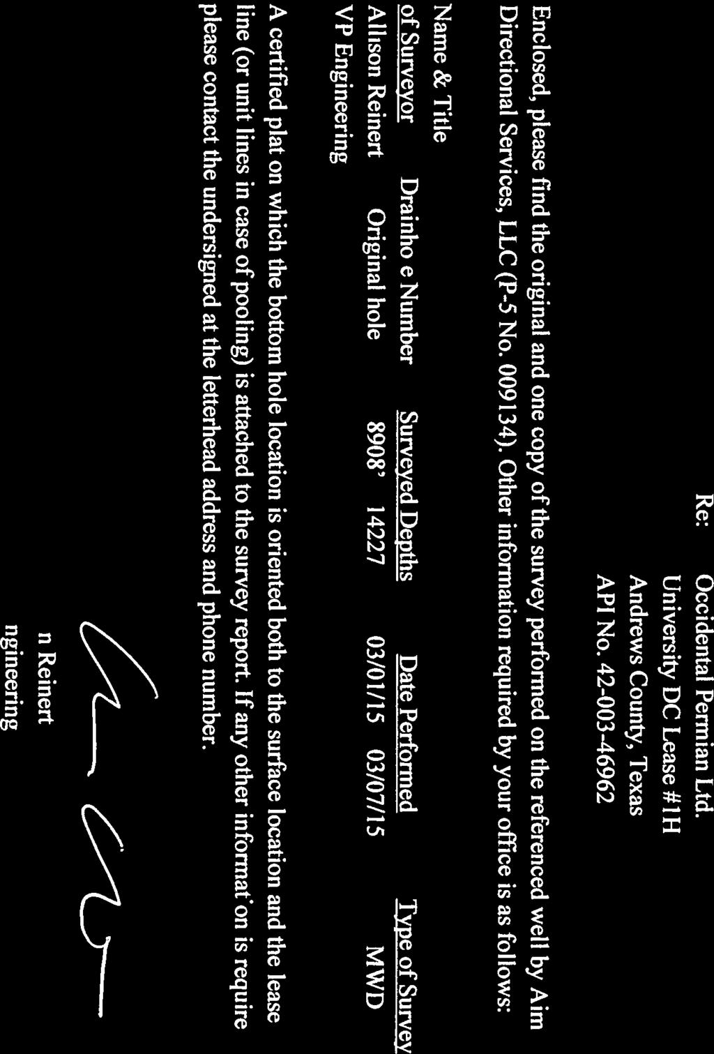


6
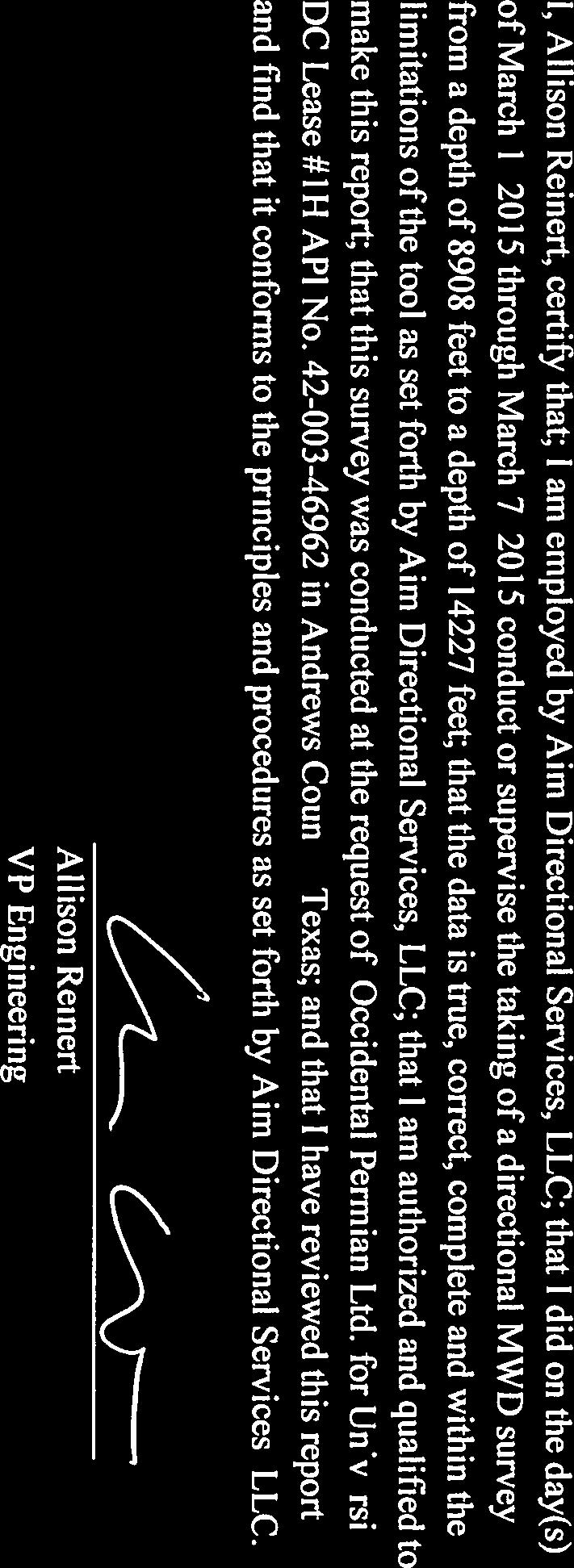


7
8 Aim Directional Services Survey Report Company: Occidental Permian Ltd. Local Co-ordinate Reference: Well #1H Project: Andrews County, Texas TVD Reference: Site: University DC #1H MD Reference: Well: #1H North Reference: Grid Wellbore: Aim MWD Surveys Survey Calculation Method: Minimum Curvature Design: Aim MWD Surveys Database: EDM Single User Db Project Andrews County, Texas Map System: Geo Datum: US State Plane 1927 (Exact solution) NAD 1927 (NADCON CONUS) System Datum: Mean Sea Level Map Zone: Texas North Central 4202 Site University DC #1H Site Position: From: Position Uncertainty: Map 0.00 usft Northing: Easting: Slot Radius: 328, usft 490, /16 Latitude: 32 28' N usft Longitude: ' W " Grid Convergence: Well #1H Well Position 0.00 usft Northing: 328, usft Latitude: 32 28' N 0.00 usft Easting: 490, usft Longitude: ' W Position Uncertainty 0.00 usft Wellhead Elevation: 0.00 usft Ground Level: 3, usft Wellbore Aim MWD Surveys Magnetics Model Name Sample Date Declination Dip Angle Field Strength (nt) HDGM 2/28/ ,325 Design Aim MWD Surveys Audit Notes: Version: 1.0 Phase: ACTUAL Tie On : 8, Section: From (TVD) Direction Survey Program Date 3/8/2015 From To Survey (Wellbore) Tool Name Description , Original Hole Surveys (Original Hole Surve 8, , Aim MWD Surveys (Aim MWD Surveys) MWD+HDGM MWD+HDGM OWSG MWD + HDGM OWSG MWD + HDGM Survey Measured Inclination Azimuth Section Dogleg Build Turn 8, , Tie into Original Hole Surveys 8, , , , , , , , , , , , , , , , /6/2015 8:56:36AM Page 1 COMPASS Build 72
9 Aim Directional Services Survey Report Company: Occidental Permian Ltd. Local Co-ordinate Reference: Well #1H Project: Andrews County, Texas TVD Reference: Site: University DC #1H MD Reference: Well: #1H North Reference: Grid Wellbore: Aim MWD Surveys Survey Calculation Method: Minimum Curvature Design: Aim MWD Surveys Database: EDM Single User Db Survey Measured Inclination Azimuth Section Dogleg Build Turn 9, , , , , , , , , , , , , , , , , , , , , , , , , , , , , , , , , , , , , , , , , , , , , , , , , , , , , , , , , , , , , , , , , , , , , , , , , , , , , , , , , , , , , , , , , , , , , , , , , , , , , , , , , , , , , , , , , , , , , , /6/2015 8:56:36AM Page 2 COMPASS Build 72
10 Aim Directional Services Survey Report Company: Occidental Permian Ltd. Local Co-ordinate Reference: Well #1H Project: Andrews County, Texas TVD Reference: Site: University DC #1H MD Reference: Well: #1H North Reference: Grid Wellbore: Aim MWD Surveys Survey Calculation Method: Minimum Curvature Design: Aim MWD Surveys Database: EDM Single User Db Survey Measured Inclination Azimuth Section Dogleg Build Turn 11, , , , , , , , , , , , , , , , , , , , , , , , , , , , , , , , , , , , , , , , , , , , , , , , , , , , , , , , , , , , , , , , , , , , , , , , , , , , , , , , , , , , , , , , , , , , , , , , , , , , , Last Aim MWD Survey Taken 14, , , , , Projection to TD Design Targets Target Name - hit/miss target - Shape Dip Angle Dip Dir. TVD Northing Easting Latitude Longitude DC #1H PBHL , , , , , ' N ' W - survey misses target center by 44.66usft at usft MD ( TVD, N, E) - Point 4/6/2015 8:56:36AM Page 3 COMPASS Build 72
11 Aim Directional Services Survey Report Company: Occidental Permian Ltd. Local Co-ordinate Reference: Well #1H Project: Andrews County, Texas TVD Reference: Site: University DC #1H MD Reference: Well: #1H North Reference: Grid Wellbore: Aim MWD Surveys Survey Calculation Method: Minimum Curvature Design: Aim MWD Surveys Database: EDM Single User Db Survey Annotations Measured Local Coordinates Comment 8, , Tie into Original Hole Surveys 14, , , , Last Aim MWD Survey Taken 14, , , , Projection to TD Checked By: Approved By: Date: 4/6/2015 8:56:36AM Page 4 COMPASS Build 72
12
Report Date: ST. ANDREWS Rig: H&P 629 Operator: Lat/Long: 6.67 East Vertical Section Azimuth: Magnetic Declination: 0.00 North Reference: True North
 Directional Company: AIM Report Date: 11/12/14 12:35:51 HP 629 Location: ST. ANDREWS ST. ANDREWS Rig: H&P 629 Operator: ISYS TOOLS State: TEXAS Lat/Long: 32 22 0.84" N 102 25 0.89" E County: ANDREWS Magnetic
True North Directional Services Inc. Survey Report
 AA Pad AA16, Slot #09 MWD Run #4 Job No. AB-CD-12345678 Date: 11 January 2013 True North Directional Services Inc. Report 17 August 2015 Surface Coordinates: 6,789,330.21 N, 572,493.04 E (61 14' 00.2426"
National Oilwell Varco Survey Report
 Elevation Resources Andrews County University 1-26 Unit 5H Surveys: 271`MD - 7076`MD Survey Date: Monday, July 04, 2016 National Oilwell Varco Survey Report Sunday, July 10, 2016 UWI No. 42-003-47118 Surface
True North Directional Services Inc. Survey Report
 Anglian Oil Company Ltd. Northern Lights AA Pad AA16, Slot #09 MWD Run #4 Job No. AB-CD-12345678 Date: 11 January 2013 True North Directional Services Inc. KellyDown - Version: 3.00.00.04 Project Northern
Diamondback E&P LLC. Standard Survey Report. Andrews County, Tx UL Tawny Unit 8-12 #3LS OH. Design: OH
 Diamondback E&P LLC Andrews County, Tx 42-003-46363 OH Design: OH Standard Report 21 May, 2015 Report Local Co-ordinate Reference: Well Calculation Method: Minimum Curvature Project Andrews County, Tx
National Oilwell Varco Survey Report
 Conoco Phillips Andrews County University Andrews 3604HL Surveys: 192`MD - 1369`MD Survey Date: Friday, January 22, 2016 National Oilwell Varco Survey Report Monday, January 25, 2016 UWI No. 42-003-47296
Company: HighMount Exploration & Production Site: University Unit Well: #11-3H Project: Crockett County, Texas (NAD 27) Rig Name: Nabors M17
 Rig Name: Nabors M17") Rig Name: Nabors M17 G T M s to North True North: 0.35 Magnetic North: 6.36 Magnetic Field Strength: 47821.6snT Dip Angle: 59.31 Date: 12/04/2013 Model: WMM_2010 ANNOTATIONS MD Inc Azi TVD VSect Departure
Rig Name: Nabors M17 G T M s to North True North: 0.35 Magnetic North: 6.36 Magnetic Field Strength: 47821.6snT Dip Angle: 59.31 Date: 12/04/2013 Model: WMM_2010 ANNOTATIONS MD Inc Azi TVD VSect Departure
Elk River Resources, LLC Andrews County, TX Sec 24, Blk 12, University Land Survey Wapiti H Wellbore #1 Survey: MWD Surveys (QES) QES Survey Re
 QES Survey Re") Elk River Resources, LLC Andrews County, TX Sec 24, Blk 12, University Land Survey Wapiti 12-24 1H Wellbore #1 Survey: MWD Surveys (QES) QES Survey Report 08 February, 2017 QES Directional Drilling, LLC
Elk River Resources, LLC Andrews County, TX Sec 24, Blk 12, University Land Survey Wapiti 12-24 1H Wellbore #1 Survey: MWD Surveys (QES) QES Survey Report 08 February, 2017 QES Directional Drilling, LLC
Regulatory Report (Grid North)
") EP Energy Reagan County, TX (NAD27 TC) University Central 8-24 N,O,P,Q,R Pad University Central 8-24 QH OH Design: OH Regulatory Report (Grid North) 17 August, 2016 Regulatory Report (Grid North) Company:
EP Energy Reagan County, TX (NAD27 TC) University Central 8-24 N,O,P,Q,R Pad University Central 8-24 QH OH Design: OH Regulatory Report (Grid North) 17 August, 2016 Regulatory Report (Grid North) Company:
El Paso E & P Company, L.P. SDI Standard Survey Report
 El Paso E & P Company, L.P. Irion County, TX (NAD27 TC) OH - Job #32D0312379 Survey: MWD 08 June, 2012 Local Co-ordinate Reference: Site Project Irion County, TX (NAD27 TC) Map System: Geo Datum: Map Zone:
FIELD COPY ONLY (NOT DEFINITIVE) Depth Reference : GROUND LEVEL
 Depth Reference : GROUND LEVEL") Company: SEQUITUR Lease/ UNIVERSITY LUCY / API: 42-235-36007 Rig Name: INTEGRITY 3 State/County: TEXAS/IRION VS-Azi: 0.00 Degrees Latitude: 31.10156, Longitude: -101.20634 North = True North +0.45 degs
Company: SEQUITUR Lease/ UNIVERSITY LUCY / API: 42-235-36007 Rig Name: INTEGRITY 3 State/County: TEXAS/IRION VS-Azi: 0.00 Degrees Latitude: 31.10156, Longitude: -101.20634 North = True North +0.45 degs
El Paso E & P Company, L.P. SDI Standard Survey Report
 El Paso E & P Company, L.P. Reagan County, TX (NAD27 TC) OH - Job #32D0112012 : MWD 2nd ST SDI Standard Report 05 March, 2012 SDI Standard Report Local Co-ordinate Reference: Site MD Reference: Wellbore:
 Apache Corporation Reagan County, TX (NAD27 TC) University 2303 E OH - Job #1114-MPH-1347 Survey: SDI MWD #1 Regulatory Report (Grid North) 14 January, 2015 Regulatory Report (Grid North) Company: Apache
ARES ENERGY, LTD. SDI Survey Report. Fuhrman-Mascho Andrews County, Texas (Grid North) University 13 #2H VH - Job # KW-204.
 University 13 #2H VH - Job # KW-204.") ARES ENERGY, LTD. Fuhrman-Mascho Andrews County, Texas (Grid North) University 13 #2H VH - Job #320214-KW-204 Survey: Gyro SDI Survey Report 17 February, 2014 SDI SDI Survey Report Company: ARES ENERGY,
ARES ENERGY, LTD. Fuhrman-Mascho Andrews County, Texas (Grid North) University 13 #2H VH - Job #320214-KW-204 Survey: Gyro SDI Survey Report 17 February, 2014 SDI SDI Survey Report Company: ARES ENERGY,
SDI Standard Survey Report
 BHP Billiton Petroleum Crockett County, Texas (NAD 83 TXC) OH - Job #32D0712949 : MWD 24 August, 2012 Local Co-ordinate Reference: Well MD Reference: Wellbore: OH - Job #32D0712949 Calculation Method:
Crane County, TX Sec. 37, Block 31, University Lands Survey University Lands A 37 #1H. Wellbore #1. Survey: MWD
 Crane County, TX Sec. 37, Block 31, University Lands Wellbore #1 : MWD 16 May, 2012 Date: 1/12/12 Railroad Commission of Texas Oil and Gas Division 1701 North Congress Avenue Austin, Texas 78711 Attention:
SDI Standard Survey Report
 BHP Billiton Petroleum Crockett County, Texas (NAD 83 TXC) OH - Job #32D0512661 Design: Actual 03 July, 2012 Local Co-ordinate Reference: Site MD Reference: Wellbore: OH - Job #32D0512661 Calculation Method:
 NABORS DRILLING TENOLOGIES USA, INC. 515 West Greens Road Houston, TX 77067 Phone: 281.874.0035 Fax: 281.872.5205 Friday, June 30, 2017 Railroad Commission of Texas Oil and Gas Division PO Box 12967 Capitol
US ROCKIES REGION PLANNING
 US ROCKIES REGION Plan: Standard 02 May, 2013 650 0 West(-)/East(+) -1300-650 0 650 1300 1950 2600 3250 9 5/8" 7" 650 0 Section: Sec. 5-T2N-R66W SHL: 226' FSL 1754' FWL SEC. 5 Latitude: 40.160463 Longitude:
US ROCKIES REGION PLANNING
 Plan: (wp01) Standard 15 March, 2012 12000 11000 91 10000 9000 5000 3750 West(-)/East(+) (2500 ft/in) -5000-3750 -2500-1250 0 1250 2500 3750 5000 5000 3750 T M s to North Magnetic North: 8.61 Magnetic
Regulatory Report (Grid North)
") Forge Energy Winkler County, TX (NAD 27 TC) UL 20 Tensleep #1H OH Survey: SDI Keeper Gyro Drop Regulatory Report (Grid North) 06 December, 2016 Regulatory Report (Grid North) Company: Forge Energy Local
Forge Energy Winkler County, TX (NAD 27 TC) UL 20 Tensleep #1H OH Survey: SDI Keeper Gyro Drop Regulatory Report (Grid North) 06 December, 2016 Regulatory Report (Grid North) Company: Forge Energy Local
Forge Energy. Andrews County, TX. Slot: No. 4426H Facility: Well: Andrews County, TX (NAD 83 / Grid) Wellbore: (UL 13 Dover) Sec 26, Blk 13, USLS
 Wellbore: (UL 13 Dover) Sec 26, Blk 13, USLS") Location: Forge Energy Andrews County, TX Slot: H&P 461 Field: Andrews County, TX (NAD 83 / Grid) Well: No. 4426H Facility: (UL 13 Dover) Sec 26, Blk 13, USLS Wellbore: Plot reference wellpath is True
Location: Forge Energy Andrews County, TX Slot: H&P 461 Field: Andrews County, TX (NAD 83 / Grid) Well: No. 4426H Facility: (UL 13 Dover) Sec 26, Blk 13, USLS Wellbore: Plot reference wellpath is True
RAILROAD COMMISSION OF TEXAS Oil & Gas Division P.O. Drawer Capitol Station Austin, TX
 Evaluation, Drilling & Intervention 10000 West County Rd. 116 P.O. Box 61028 Midland, TX USA 79711 Tel. (432) 561-8892 Fax (432) 561-8895 RAILROAD COMMISSION OF TEXAS Oil & Gas Division P.O. Drawer 12967
SlimPulse FS Original Hole Ft August 12, 2017
 Oilfield Services, Central U.S. Land Schlumberger Drilling and Measurements Drilling Group Geo Market Area: South West Texas Basin 7220 W I-H 20 Midland, Texas 79706 Phone : (432) 742-5400 (Main) Fax :(432)
SUMMARY OF BOTTOM HOLE LOCATIONS CIMAREX ENERGY CO. 11,252'
 SUMMARY OF BOTTOM HOLE LOCATIONS CIMAREX ENERGY CO. Lehman BIA 2-11H Section 11-15N-11W Blaine Co., Oklahoma Cause CD Number: 201803401-T Interim Order Number: 683171 Lehman BIA 2-11H MD TVD Location Surface
This paper was prepared for presentation at the Unconventional Resources Technology Conference held in San Antonio, Texas, USA, July 2015.
 URTeC: 2173526 Enhanced Wellbore Placement Accuracy Using Geomagnetic In-Field Referencing and Multi-Station Correction Stefan Maus, Magnetic Variation Services, Shawn DeVerse, Surcon. Copyright 2015,
The SPE Foundation through member donations and a contribution from Offshore Europe
 Primary funding is provided by The SPE Foundation through member donations and a contribution from Offshore Europe The Society is grateful to those companies that allow their professionals to serve as
Town of Chino Valley. Survey Control Network Report. mgfneerhg mc N. Willow Creek Road Prescott AZ
 Town of Chino Valley Survey Control Network Report mgfneerhg mc. 2050 N. Willow Creek Road Prescott AZ 86301 928-771-2376 Page 1 of 70 Table of Contents Town of Chino Valley Survey Datum Outline A short
Downhole Navigation for Oil & Gas Drilling
 Downhole Navigation for Oil & Gas Drilling Martin E. Poitzsch Research Director, Sensor Physics Schlumberger-Doll Research, Cambridge, MA A Division of Schlumberger Ltd. Outline Importance of Accurate
FS Original Hole Ft April 26, 2016
 Oilfield Services, Central U.S. Land PathFinder A Schlumberger Company Drilling Group Geo Market Area: South East Texas Basin 3600 BriarPark Houston, Texas 77042 Phone : (713) 789-9600 (Main) Fax : (713)
VT State Plane. Daniel J. Martin National Geodetic Survey VT Geodetic Advisor. VSLS Conference Rutland VT April 11, 2008
 VT State Plane Daniel J. Martin National Geodetic Survey VT Geodetic Advisor VSLS Conference Rutland VT April 11, 2008 Today s Outline Define the problem Review of VT State Plane System Relationship
HORIZONTAL PROJECTION PARAMETERS: DANE COUNTY COORDINATES
 Recommended RTK GPS Configuration Parameters for the City of Madison, WI Base Station Compiled by: Dan Rodman RLS, City of Madison (608)266-6674 drodman@cityofmadison.com For base station information see
Geodetics: Implications for GIS Professionals May 10, 2018
 Experts in Geomatics, Surveying, Positioning, Geospatial Data, and Mapping Sciences Geodetics: Implications for GIS Professionals May 10, 2018 Michael Barnes APSG Education Foundation Chair 2010-2020 APSG
Shape e o f f the e Earth
 1 Coordinate Systems & Projections Coordinate Systems Two map layers are not going to register spatially unless they are based on the same coordinate system. 2 Contents Shape of the earth Datum Projections
2019 Settlement Calendar for ASX Cash Market Products. ASX Settlement
 2019 Settlement Calendar for ASX Cash Market Products ASX Settlement Settlement Calendar for ASX Cash Market Products 1 ASX Settlement Pty Limited (ASX Settlement) operates a trade date plus two Business
Introduction to Geographic Information Science. Updates/News. Last Lecture. Geography 4103 / Map Projections and Coordinate Systems
 Geography 4103 / 5103 Introduction to Geographic Information Science Map Projections and Coordinate Systems Updates/News Thursday s lecture Reading discussion 1 find the readings online open questions,
How does an ellipsoid differ from a sphere in approximating the shape and size of the Earth?
 Chapter 02 Test Bank Worksheet Questions 1. What is a map projection? Topic: Map Projection 2. How does an ellipsoid differ from a sphere in approximating the shape and size of the Earth? Topic: Ellipsoid
PRESENTATION TITLE. Drone Magnetic Site Surveys To Verify Wellhead Locations David M. Velozzi 9/27/18
 1 PRESENTATION TITLE Drone Magnetic Site Surveys To Verify Wellhead Locations David M. Velozzi 9/27/18 Speaker Information David M. Velozzi Geoscience Team Lead Magnetic Variation Services (MagVAR) (A
DEVIATION SURVEY CALCULATIONS USING CURVATURE METHOD DSCM PROGRAM
 DEVIATION SURVEY CALCULATIONS USING CURVATURE METHOD DSCM PROGRAM Author Dr. Ziad Amer Hammoodi Ex Technical Team Leader ADMA-OPCO Ex. Reservoir Engineering Software Specialist - ADNOC 1 1- INTRODUCTION
What is Geodesy? Types of Geodesy terrestrial or classical geodesy space geodesy theoretical geodesy
 What is Geodesy? Geodesy is the study of: The size, shape and motion of the earth The measurement of the position and motion of points on the earth's surface, and The study of the earth's gravity field
This week s topics. Week 6. FE 257. GIS and Forest Engineering Applications. Week 6
 FE 257. GIS and Forest Engineering Applications Week 6 Week 6 Last week Chapter 8 Combining and splitting landscape features and merging GIS databases Chapter 11 Overlay processes Questions? Next week
Monthly Magnetic Bulletin
 BRITISH GEOLOGICAL SURVEY Ascension Island Observatory Monthly Magnetic Bulletin March 2017 17/03/AS Crown copyright; Ordnance Survey ASCENSION ISLAND OBSERVATORY MAGNETIC DATA 1. Introduction Ascension
4 Survey Datums. 4.1 Horizontal Datum Policy SURVEY DATUMS SEPTEMBER 2006
 4 Survey Datums Today s multi-organizational Project Development efforts require the use of common, accurate horizontal and vertical survey datums and consistent, precise control-survey procedures to ensure
TOWN OF SEVERANCE, COLORADO. NOTICE OF PUBLIC HEARINGS FOR A PROJECT Hunters Crossing Annexation & Zoning
 TOWN OF SEVERANCE, COLORADO NOTICE OF PUBLIC HEARINGS FOR A PROJECT Hunters Crossing Annexation & Zoning NOTICE IS HEREBY GIVEN that the Public Hearing required by C.R.S. 31-12-108 before the Severance
Monthly Magnetic Bulletin
 BRITISH GEOLOGICAL SURVEY Fort McMurray Observatory Monthly Magnetic Bulletin February 2016 16/02/FM Fort McMurray FORT McMURRAY OBSERVATORY MAGNETIC DATA 1. Introduction The British Geological Survey
1. Geospatial technology rarely links geospatial data to nonspatial data. a. True *b. False
 Chapter 2 Where in the Geospatial World Are You? 1. Geospatial technology rarely links geospatial data to nonspatial data. 2. For geospatial technology to work, every location on Earth must be: a. inhabited
Monthly Magnetic Bulletin
 BRITISH GEOLOGICAL SURVEY Fort McMurray Observatory Monthly Magnetic Bulletin March 2017 17/03/FM Fort McMurray FORT McMURRAY OBSERVATORY MAGNETIC DATA 1. Introduction The British Geological Survey (BGS)
Metadata for 2005 Orthophotography Products
 Metadata for 2005 Orthophotography Products What does this data set describe? 1. How should this data set be cited? 2. What geographic area does the data set cover? 3. What does it look like? 4. Does the
2017 Settlement Calendar for ASX Cash Market Products ASX SETTLEMENT
 2017 Settlement Calendar for ASX Cash Market Products ASX SETTLEMENT Settlement Calendar for ASX Cash Market Products 1 ASX Settlement Pty Limited (ASX Settlement) operates a trade date plus two Business
Published by ASX Settlement Pty Limited A.B.N Settlement Calendar for ASX Cash Market Products
 Published by Pty Limited A.B.N. 49 008 504 532 2012 Calendar for Cash Market Products Calendar for Cash Market Products¹ Pty Limited ( ) operates a trade date plus three Business (T+3) settlement discipline
LONGITUDE AND LATITUDE. Semi great circles joining the true or geographic poles of the earth (true meridians).
.") MERIDIANS OF LONGITUDE LONGITUDE AND LATITUDE Semi great circles joining the true or geographic poles of the earth (true meridians). They are measured from 0 to 180 degrees East and West of the PRIME MERIDIAN,
MERIDIANS OF LONGITUDE LONGITUDE AND LATITUDE Semi great circles joining the true or geographic poles of the earth (true meridians). They are measured from 0 to 180 degrees East and West of the PRIME MERIDIAN,
Lecture 4. Coordinate Systems & Projections
 Lecture 4 Coordinate Systems & Projections Outline Geodesy Geoids Ellipsoids Geographic Coordinate Systems Magnetic North vs. True North Datums Projections Applying Coordinate Systems and Projections Why
Preventing Coordinate- System Confusion (maybe?)
") Preventing Coordinate- System Confusion (maybe?) Montana Association of Registered Land Surveyors 2008 Convention Bozeman, Montana 07 & 08 February 2008 Glenn Borkenhagen Inland GPS Inc. - Cody, Wyoming
Preventing Coordinate- System Confusion (maybe?) Montana Association of Registered Land Surveyors 2008 Convention Bozeman, Montana 07 & 08 February 2008 Glenn Borkenhagen Inland GPS Inc. - Cody, Wyoming
Systematic and Random Contributions to the Disturbance Field (IFR 2)
") Systematic and Random Contributions to the Disturbance Field (IFR 2) Objectives of the study: Quantify systematic disturbance field errors Propose missing coefficients needed for QC Analysis of global
Systematic and Random Contributions to the Disturbance Field (IFR 2) Objectives of the study: Quantify systematic disturbance field errors Propose missing coefficients needed for QC Analysis of global
OKLAHOMA CORPORATION COMMISSION OIL & GAS CONSERVATION DIVISION P.O. BOX OKLAHOMA CITY, OK (Rule 165:10-3-1) PERMIT TO DRILL
 PERMIT TO DRILL") API NUMBER: 039 Horizontal Hole 22504 Oil & Gas OKLAHOMA CORPORATION COMMISSION OIL & GAS CONSERVATION DIVISION P.O. BOX 52000 OKLAHOMA CITY, OK 73152-2000 (Rule 165:10-3-1) Approval Date: 06/05/2017 Expiration
API NUMBER: 039 Horizontal Hole 22504 Oil & Gas OKLAHOMA CORPORATION COMMISSION OIL & GAS CONSERVATION DIVISION P.O. BOX 52000 OKLAHOMA CITY, OK 73152-2000 (Rule 165:10-3-1) Approval Date: 06/05/2017 Expiration
Outline. Shape of the Earth. Geographic Coordinates (φ, λ, z) Ellipsoid or Spheroid Rotate an ellipse around an axis. Ellipse.
 Ellipsoid or Spheroid Rotate an ellipse around an axis. Ellipse.") Map Projections Outline Geodesy and map projections Prof. D. Nagesh Kumar Department of Civil Engineering Indian Institute of Science Bangalore 560 012, India http://www.civil.iisc.ernet.in/~nagesh Shape
Map Projections Outline Geodesy and map projections Prof. D. Nagesh Kumar Department of Civil Engineering Indian Institute of Science Bangalore 560 012, India http://www.civil.iisc.ernet.in/~nagesh Shape
Guideline Petroleum Drilling Regulations (CNR 1150/96)
") Government of Newfoundland and Labrador Department of Natural Resources Guideline Petroleum Drilling Regulations (CNR 1150/96) Topic: Final Well Report Onshore Petroleum Exploratory Wells Ref: Section
Government of Newfoundland and Labrador Department of Natural Resources Guideline Petroleum Drilling Regulations (CNR 1150/96) Topic: Final Well Report Onshore Petroleum Exploratory Wells Ref: Section
The Wildlife Society Meet and Greet. Come learn about what the UNBC Student Chapter of TWS is all about!
 Georeferencing I GEOG 300, Lecture 4 Dr. Anthony Jjumba 1 The Wildlife Society Meet and Greet Quiz Come learn about what the UNBC Student Chapter of TWS is all about! 5:30 7:30 PM, Wednesday September
RAILROAD COMMISSION OF TEXAS OIL WELL POTENTIAL TEST, COMPLETION OR RECOMPLETION REPORT, AND LOG
 RAILROAD COMMISSION OF TEXAS 1701 N. Congress P.O. Box 12967 Austin, Texas 78701-2967 Status: Form W-2 OIL WELL POTENTIAL TEST, COMPLETION OR RECOMPLETION REPORT, AND LOG Date: Tracking.: Approved 01/05/2016
Latitude and Longitude Pre Test
 Name Date Latitude and Longitude Pre Test Multiple Choice Directions: For questions, 1 10 circle the answer that letter that best answers the question. Each question is worth 1 point each. 1. To locate
Shale Gas; Wellbore Positioning Challenges
 Shale Gas; Wellbore Positioning Challenges Pete Clark, Directional Drilling Advisor ISCWSA, Copenhagen, 3/4/11 Shale Gas; Wellbore Positioning Challenges Why is it important to us? Emerging trend in drilling
Advances in Geosteering
 Advances in Geosteering SMART4D While Drilling Geosteering Marcellus Case Study Joint Presentation: Feb 27 th 2014, Houston, TX Rocky Mottahedeh, P.Geol. P.Eng. EOW Report University_31_18_2H Advances
Monthly Magnetic Bulletin
 BRITISH GEOLOGICAL SURVEY Port Stanley Observatory Monthly Magnetic Bulletin July 2011 11/07/PS Jason Islands West Falkland King George Bay Queen Charlotte Bay Weddell Island Caracass Island Saunders Island
GEOPHYSICAL DATA SET (GDS) 1084B METADATA
 1084B METADATA") GEOPHYSICAL DATA SET (GDS) 1084B METADATA GENERAL INFORMATION Official Name of the Data Set or Information Holding: Ontario Airborne Geophysical Surveys, Magnetic Gradiometer and Gamma-Ray Spectrometric
GEOPHYSICAL DATA SET (GDS) 1084B METADATA GENERAL INFORMATION Official Name of the Data Set or Information Holding: Ontario Airborne Geophysical Surveys, Magnetic Gradiometer and Gamma-Ray Spectrometric
AGGREGATE RESOURCES OF ONTARIO (ARO) METADATA
 METADATA") AGGREGATE RESOURCES OF ONTARIO (ARO) METADATA GENERAL INFORMATION Official Name of the Data Set or Information Holding: Aggregate Resources of Ontario Acronyms are Used to Identify the Data Set or Information
AGGREGATE RESOURCES OF ONTARIO (ARO) METADATA GENERAL INFORMATION Official Name of the Data Set or Information Holding: Aggregate Resources of Ontario Acronyms are Used to Identify the Data Set or Information
Welcome to Lesson 4. It is important for a GIS analyst to have a thorough understanding of map projections and coordinate systems.
 Welcome to Lesson 4. It is important for a GIS analyst to have a thorough understanding of map projections and coordinate systems. A GIS without coordinates would simply be a database like Microsoft Excel
Improved Geomagnetic Referencing in the Arctic Environment
 SPE-166850 Improved Geomagnetic Referencing in the Arctic Environment Benny Poedjono and Nathan Beck, SPE, Schlumberger; Andrew Buchanan and Luca Borri, Eni Petroleum Co.; Stefan Maus, SPE, Magnetic Variation
What is a Map Projection?
 What is a Map Projection? It is how we represent a three dimensional Earth on a flat piece of paper However The process of transferring information from the Earth to a map causes every projection to distort
Control Surveys and Coordinate Systems
 Control Surveys and Coordinate Systems The Earth is Round Basic Shape of the Earth: Oblate Spheroid of Revolution The length of the equatorial axis is approximately 27 miles greater than the polar axis.
GIS in Water Resources. Fall Homework #1
 GIS in Water Resources Fall 2015 Homework #1 Goal The goal of this homework is to reinforce the lecture material on Geodesy, Map Projections and Coordinate Systems by having you identify attributes and
OKLAHOMA CORPORATION COMMISSION OIL & GAS CONSERVATION DIVISION P.O. BOX OKLAHOMA CITY, OK (Rule 165:10-3-1) PERMIT TO DRILL
 PERMIT TO DRILL") API NUMBER: 039 Horizontal Hole 22513 Oil & Gas OKLAHOMA CORPORATION COMMISSION OIL & GAS CONSERVATION DIVISION P.O. BOX 52000 OKLAHOMA CITY, OK 73152-2000 (Rule 165:10-3-1) Approval Date: 08/11/2017 Expiration
API NUMBER: 039 Horizontal Hole 22513 Oil & Gas OKLAHOMA CORPORATION COMMISSION OIL & GAS CONSERVATION DIVISION P.O. BOX 52000 OKLAHOMA CITY, OK 73152-2000 (Rule 165:10-3-1) Approval Date: 08/11/2017 Expiration
Name Class Date. For each pair of terms, explain how the meanings of the terms differ.
 Skills Worksheet Chapter Review USING KEY TERMS For each pair of terms, explain how the meanings of the terms differ. 1. true north and magnetic north 2. latitude and longitude 3. equator and prime meridian
KING EDWARD POINT OBSERVATORY MAGNETIC DATA
 BRITISH GEOLOGICAL SURVEY King Edward d Point Observatory Monthly Magnetic Bulletin May 2018 18/05/KE King Edward Point (UK) Maps British Antarctic Survey KING EDWARD POINT OBSERVATORY MAGNETIC DATA 1.
Georeferencing, Map Projections, Cartographic Concepts. -Coordinate Systems -Datum
 Georeferencing, Map Projections, Cartographic Concepts -Map Projections -Coordinate Systems -Datum Map projection is "the process of systematically transforming positions on the Earth's spherical surface
KING EDWARD POINT OBSERVATORY MAGNETIC DATA
 BRITISH GEOLOGICAL SURVEY King Edward d Point Observatory Monthly Magnetic Bulletin September 2018 18/09/KE King Edward Point (UK) Maps British Antarctic Survey KING EDWARD POINT OBSERVATORY MAGNETIC DATA
GISC3325 Spring 2011 Final Exam
 GISC3325 Spring 2011 Final Exam Name: Carefully read each question. Identify the important elements and the question being asked. Show your work for partial credit. No credit for undocumented wrong answers.
INTRODUCTION FOREWORD
 FOREWORD The Sight Reduction Tables for Air Navigation consist of three volumes of comprehensive tables of altitude and azimuth designed for the rapid reduction of astronomical sights in the air. This
GEOSYNTEC CONSULTANTS
 GEOSYNTEC CONSULTANTS 2100 Main Street, Suite 150 Huntington Beach, CA 92648 USA Tel (714) 969-0800 Fax (714) 969-0820 15 February 2006 Ms. Tamara Zeier, P.E. Project Manager Project Navigator, Ltd. One
KING EDWARD POINT OBSERVATORY MAGNETIC DATA
 BRITISH GEOLOGICAL SURVEY King Edward d Point Observatory Monthly Magnetic Bulletin October 2018 18/10/KE King Edward Point (UK) Maps British Antarctic Survey KING EDWARD POINT OBSERVATORY MAGNETIC DATA
OSISKO METALS INTERSECTS 10.49% ZINC+LEAD OVER METRES AND 12.15% ZINC+LEAD OVER METRES AT PINE POINT
 OSISKO METALS INTERSECTS 10.49% ZINC+LEAD OVER 22.84 METRES AND 12.15% ZINC+LEAD OVER 17.00 METRES AT PINE POINT (Montreal November 19, 2018) Osisko Metals Incorporated (the Company or Osisko Metals )
Monthly Magnetic Bulletin
 BRITISH GEOLOGICAL SURVEY Port Stanley Observatory Monthly Magnetic Bulletin July 2010 10/07/PS Jason Islands a ar C West Falkland Kin gg eor ge B Port Salavador ay Weddell Island Mount Osborne So un d
400_scale_tiles(poly)(sp_nad83)
(sp_nad83)") 400_scale_tiles(poly)(sp_nad83) Identification_Information Data_Quality_Information Spatial_Data_Organization_Information Spatial_Reference_Information Entity_and_Attribute_Information Distribution_Information
400_scale_tiles(poly)(sp_nad83) Identification_Information Data_Quality_Information Spatial_Data_Organization_Information Spatial_Reference_Information Entity_and_Attribute_Information Distribution_Information
BUILDING AN ACCURATE GIS
 BUILDING AN ACCURATE GIS 2006 GIS in the Rockies Denver, Colorado September 13, 2006 William E. Linzey United States Department of Commerce National Oceanic and Atmospheric Administration National Geodetic
Map Projections. Displaying the earth on 2 dimensional maps
 Map Projections Displaying the earth on 2 dimensional maps Map projections Define the spatial relationship between locations on earth and their relative locations on a flat map Are mathematical expressions
Public Land Survey System Knowledge Remains an Important Skill
 By Douglas S. Helmke, P.G., Water Rights / Source Water Specialist Public Land Survey System Knowledge Remains an Important Skill In our new world of global positioning system (GPS) navigation, with digital
Lower Density Growth Management Metadata
 Products > BYTES of the BIG APPLE TM Lower Density Growth Management Metadata nyldgma Data Format: Shapefile File or table name: nyldgma Data Projection: NAD_1983_StatePlane_New_York_Long_Island_FIPS_3104_Feet
Understanding Projections for GIS
 Presented by John Schaeffer Juniper GIS Services, Inc. This PowerPoint is available at JuniperGIS.com Presentation Objectives To understand basic concepts on projections and coordinate systems for the
NR402 GIS Applications in Natural Resources Lesson 4 Map Projections
 NR402 GIS Applications in Natural Resources Lesson 4 Map Projections From http://www.or.blm.gov/gis/ 1 Geographic coordinates Coordinates are expressed as Latitude and Longitude in Degrees, Minutes, Seconds
Monthly Magnetic Bulletin
 BRITISH GEOLOGICAL SURVEY Jim Carrigan Observatory Prudhoe Bay Monthly Magnetic Bulletin May 2014 14/05/JC JIM CARRIGAN OBSERVATORY MAGNETIC DATA 1. Introduction Jim Carrigan observatory is the fourth
Collision Avoidance Lexicon
 Collision Avoidance Lexicon 2017 An understanding of collision avoidance terminology requires an understanding of position uncertainty terminology. This lexicon therefore includes the terminology of both
LEADS. The Essential Elements of a 3-D Geographic Coordinate
 The Essential Elements of a 3-D Geographic Coordinate John W. Dix 13 September 2005 ESRI Homeland Security GIS Summit - Denver, CO John.W.Dix@nga.mil NATIONAL GEOSPATIAL-INTELLIGENCE AGENCY Overview is
Butte County Fire Department
 Butte County Fire Department Basic Land Navigation Verification Sheet I verify that Print Supervisor s name has completed the Print Employee s name Basic Land Navigation self study guide on. Date Attached
Meeting the ODOT Survey & Mapping Specifications
 Meeting the ODOT Survey & Mapping Specifications A Simple Solution Presented by Ray Foos, P.S, ODOT CADD & Mapping Services & Jon Keller, P.S., ODOT District 3 Phases of an ODOT Survey Project Research
Objective questions for Practical Examination (CBCS scheme) Introduction to Surveying CE-112
 Introduction to Surveying CE-112") Objective questions for Practical Examination (CBCS scheme) Introduction to Surveying CE-112 1. The curvature of the earth s surface, is taken into account only if the extent of survey is more than i)
Objective questions for Practical Examination (CBCS scheme) Introduction to Surveying CE-112 1. The curvature of the earth s surface, is taken into account only if the extent of survey is more than i)
ch02.pdf chap2.pdf chap02.pdf
 Introduction to Geographic Information Systems 8th Edition Karl Solutions Manual Full Download: http://testbanklive.com/download/introduction-to-geographic-information-systems-8th-edition-karl-solutions-manu
Modern Navigation. Thomas Herring
 12.215 Modern Navigation Thomas Herring Review of Last Class Almanacs: Paper and electronics Paper Almanacs: Nautical Almanac Electronic: Available on many web sites Homework #1 solutions 10/17/2006 12.215
SURVEYING AND MAPPING, INC. COORDINATE DATA SHEET JOB: CITY OF DECATUR CLIENT: CITY OF DECATUR SAM JOB#:
 13 March 2001 SURVEYING AND MAPPING, INC. COORDINATE DATA SHEET JOB: CITY OF DECATUR CLIENT: CITY OF DECATUR SAM JOB#: 21038-20 HORIZONTAL DATUM: NAD-83 GEODETIC VERTICAL STATION ID LATITUDE LONGITUDE
Lesson 5: Map Scale and Projections
 Organizing Data and Information Lesson 5: Map Scale and Projections Map Scales Projections Information can be organized as lists, numbers, tables, text, pictures, maps, or indexes. Clusters of information
Oil Company Company et al Foothills W6
 800, 555 4 th Avenue SW, Calgary, AB T2P 3E7 Off: 403-234-7625, www.wellsitegeologists.com Cell: 660-9883, Dennis@WellsiteGeologists.com Geological Report for Oil Company Company et al Foothills 06-06-060-06W6
Laboratory Exercise #2 Introduction to Quadrangle Maps
 page - 1 Laboratory Exercise #2 Introduction to Quadrangle Maps A. Introduction to Quadrangle Maps The United States Geological Survey has developed a nationwide series of quadrangle maps that cover small