SOUTHEAST PLANT POWER FEED AND PRIMARY SWITCHGEAR UPGRADES CIVIC DESIGN REVIEW - PHASE 1 - MAY 16, 2016
|
|
|
- Stephen Waters
- 5 years ago
- Views:
Transcription


1 SOUTHEAST PLANT POWER FEED AND PRIMARY SWITCHGEAR UPGRADES CIVIC DESIGN REVIEW - PHASE 1 - MAY 16, 2016 CITY & COUNTY OF SAN FRANCISCO PUBLIC UTILITIES COMMISSION


2 PROJECT LOCATION CALTRAIN RAILROAD RANKIN STREET 4 BUILDING LOCATION The proposed Electrical Equipment Building is located at the SFPUC SouthEast Plant (SEP) at Evans Street and Phelps Street. PROJECT OBJECTIVE To provide a building enclosure for electrical equipment that is contemporary in design and responsive to the existing structures on site. Proposed facility shall also be resistant to the corrosive environment created by the wastewater treatment plant. BUILDING SOLUTION A 4,000 square foot facility located parallel to the access road with second floor situated over existing electrical equipment to remain. The plan will allow for a linear circulation pattern that permits personnel to travel through the building from the east side to the west side. The proposed foot print is approximately 52 x 82 with a roof height of 28 to top of parapet. SURROUNDING BUILDINGS LEGEND 1. Secondary Sedimentation Tanks 2. Secondary Sludge Control Building 3. Gallery 4. Pretreatment Facility 5. Sedimentation Building 6. Aeration Tanks 7. Postchlorination Building 8. Chlorine Contact Channels 9. Administration Laboratory Buildings 10. Sedimentation Buildings 11. Dryer Building 12. Service Building 13. Operators Building 14. Small Concrete Building PHELPS STREET ACCESS ROAD 1 8 PROJECT SITE EVANS AVENUE 3RD STREET O Project Site Civic Design Review - Phase Page 2


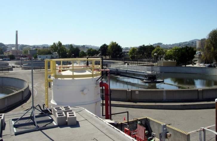


3 Southeast Plant - Surrounding Buildings Civic Design Review - Phase Page 3

4 SEDIMENTATION BUILDING SODIUM HYPOCHLORITE TANKS AERATION TANKS SECONDARY SLUDGE CONTROL BUILDING PRETREATMENT FACILITY PROJECT SITE: SEP 892 EVANS AVENUE ACCESS ROAD SECURITY WALL SECONDARY SEDIMENTATION TANKS O Site Plan Civic Design Review - Phase Page 4


5 SEP Existing Conditions Civic Design Review - Phase Page 5

6 T PB SEDIMENTATION BUILDING AERATION TANKS SECONDARY SLUDGE CONTROL BUILDING SODIUM HYPOCHLORITE TANKS DN SEP 892 DN PRETREATMENT FACILITY UP UP ACCESS ROAD EVANS AVENUE SECURITY WALL SECONDARY SEDIMENTATION TANKS O Site Plan Civic Design Review - Phase Page 6
7 T PB B DN DN DN DN 5 5 (P) SWITCHGEAR (E) TRANSFORMERS (E) SWITCHGEAR 4 4 MECHANICAL 202 SWITCHGEAR TRANSFORMER 102 SWITCHGEAR ' - 10" UP A UP A 1 1 UP UP 78' - 6" A B C D E A B C D E B Level 2 Level 1 2 LEVEL 2 - CDR 1/8" = 1'-0" 1 LEVEL 1 - CDR 1/8" = 1'-0" O Floor Plans Civic Design Review - Phase Page 7
8 ROOF 24' - 0" ROOF 24' - 0" MECHANICAL 202 LEVEL 2 12' - 0" MECHANICAL 202 LEVEL 2 12' - 0" TRANSFORMER 102 LEVEL 1 0' - 0" TRANSFORMER 102 LEVEL 1 0' - 0" Section B-B A A B C B D C D E E ROOF 24' - 0" ROOF 24' - 0" MECHANICAL SWITCHGEAR MECHANICAL SWITCHGEAR LEVEL 2 12' - 0" LEVEL 2 12' - 0" TRANSFORMER SWITCHGEAR TRANSFORMER SWITCHGEAR LEVEL 1 0' - 0" LEVEL 1 O- 0" 0' Section A-A Building Sections Civic Design Review - Phase Page 8


9 Imagery Civic Design Review - Phase Page 9

10 West Elevation South Elevation O Exterior Elevations - Option A Civic Design Review - Phase Page 10


11 East Elevation North Elevation O Exterior Elevations - Option A Civic Design Review - Phase Page 11

12 Perspective 1 - Option A Civic Design Review - Phase Page 12

13 Perspective 2 - Option A Civic Design Review - Phase Page 13
SOUTHEAST PLANT POWER FEED AND PRIMARY SWITCHGEAR UPGRADES CIVIC DESIGN REVIEW - PHASE 1 - NOVEMBER 14, 2016
 SOUTHEAST PLANT POWER FEED AND PRIMARY SWITCHGEAR UPGRADES CIVIC DESIGN REVIEW - PHASE 1 - NOVEMBER 14, 2016 CITY & COUNTY OF SAN FRANCISCO PUBLIC UTILITIES COMMISSION PROJECT LOCATION CALTRAIN RAILROAD
CITY OF PORTLAND, TEXAS SERVICE PLAN FOR ANNEXATION AREA
 CITY OF PORTLAND, TEXAS SERVICE PLAN FOR ANNEXATION AREA Location and Acreage Approximately 1,863 acres of land in San Patricio County, located in the ETJ northwest of the existing City Limits. Metes and
APPENDIX B SHADOW STUDY
 APPENDIX B SHADOW STUDY Shadow Study Methodology and Analysis Douglas Avenue Multi-Family Residential Development Project Methodology Panorama evaluated for accuracy the building foot print data provided
NARRAGANSETT BAY COMMISSION SPECIFICATIONS FOR SODIUM HYPOCHLORITE SOLUTION
 The Narragansett Bay Commission Vincent J. Mesolella Corporate Office Building Chairman One Service Road Providence, RI 02905 Raymond J. Marshall 401 461 8848 Executive Director 401 461 6540 FAX http://www.narrabay.com
About places and/or important events Landmarks Maps How the land is, hills or flat or mountain range Connected to maps World Different countries
 What do you think you know about geography? About places and/or important events Landmarks Maps How the land is, hills or flat or mountain range Connected to maps World Different countries What do you
OXFORD HEIGHTS SUBDIVISION EMERGENCY EVACUATION PLAN
 OXFORD HEIGHTS SUBDIVISION EMERGENCY EVACUATION PLAN March 27, 2007 Oxford Heights Overview and Historical Conditions Oxford Heights is a medium sized community located on the southern side of Elizabeth
225 Bush Street Suite 1700 San Francisco, CA phone fax
 225 Bush Street Suite 1700 San Francisco, CA 94104 415.896.5900 phone 415.896.0332 fax www.esassoc.com memorandum date July 29, 2009 to from subject Craig Nikitas, San Francisco Planning Department Daniel
ADMINISTRATION BUILDING
 TORNADO PROCEDURES Tornadoes are nature s most violent storms, and over a small area, the most destructive. A tornado s whirling winds may reach 300 miles per hour or more. Generally short-lived and fast
APPLICATION TO AMEND THE FUTURE LAND USE MAP (FLUM) SMALL SCALE
 SMALL SCALE") DEPARTMENT OF DEVELOPMENT & PLANNING 825 Ohio Avenue - Lynn Haven, FL 32444 (850) 265-2961 - (850) 265-3478 APPLICATION TO AMEND THE FUTURE LAND USE MAP (FLUM) SMALL SCALE Deadline to submit is 30 days
DEPARTMENT OF DEVELOPMENT & PLANNING 825 Ohio Avenue - Lynn Haven, FL 32444 (850) 265-2961 - (850) 265-3478 APPLICATION TO AMEND THE FUTURE LAND USE MAP (FLUM) SMALL SCALE Deadline to submit is 30 days
Noise Maps, Report & Statistics, Dublin City Council Noise Mapping Project Roads and Traffic Department
 Noise Maps, Report & Statistics, Dublin City Council Noise Mapping Project Roads and Traffic Department Produced by Traffic Noise & Air Quality Unit November 2007 Contact: brian.mcmanus@dublincity.ie Ph;
Pinellas County Capital Improvement Program, FY2006 Through FY2011 Project Summary Report
 Function : General Government Services Activity : Judicial Project No: 923 Title: Courts/Jails Future Expansion Cost Center: 8160500 Department: General Services Primary Fund: 0401 CIE: No Sub-cost Center:
Public Land Survey System Knowledge Remains an Important Skill
 By Douglas S. Helmke, P.G., Water Rights / Source Water Specialist Public Land Survey System Knowledge Remains an Important Skill In our new world of global positioning system (GPS) navigation, with digital
PUP R-4 R-3 R-4 R-3 R-4 B-1 B-3 B-1 B-1 B-1 R-3 C-1 R-3 R-3 A-1 M-2C SUBJECT PROPERTY B-3 R-5 B-3C B-3C B-3C B-3C B-2.
 0 0 0 0 0 00 0 EARLY AVE 00 0 0 0 0 0 R- 0 0 0 C- 0 0 0 0 0 0 R- 0 B- 00 0 0 0 0 0 0 CARTER AVE EAST SIDE LN 0 0 0 JACKSON AVE 00 0 0 A- Parcels or Portions thereof identified on this sheet are within
Currently, the Plan Area includes over nine acres of impermeable surface parking around the Kmart, Michaels, and Shell station facilities.
 Chapter 2 Currently, the Plan Area includes over nine acres of impermeable surface parking around the Kmart, Michaels, and Shell station facilities. At present, only about six percent of the entire Plan
Reserve Forecast Details
 10-26th St South of Maryland Reserve (1552) Opening Balance 158,947 158,947 0 0 0 0 0 0 0 0 1058 - Street Construction 0 (158,947) 0 0 0 0 0 0 0 0 Total 0 (158,947) 0 0 0 0 0 0 0 0 Closing Balance 158,947
Write a report (6-7 pages, double space) on some examples of Internet Applications. You can choose only ONE of the following application areas:
 on some examples of Internet Applications. You can choose only ONE of the following application areas:") UPR 6905 Internet GIS Homework 1 Yong Hong Guo September 9, 2008 Write a report (6-7 pages, double space) on some examples of Internet Applications. You can choose only ONE of the following application
UPR 6905 Internet GIS Homework 1 Yong Hong Guo September 9, 2008 Write a report (6-7 pages, double space) on some examples of Internet Applications. You can choose only ONE of the following application
ORDINANCE NO
 ORDINANCE NO. 174421 VAN NUYS CENTRAL BUSINESS DISTRICT COMMUNITY DESIGN OVERLAY PERMANENT [Q] CONDITIONS ORDINANCE An ordinance AMENDING Section 12.04 of the Los Angeles Municipal Code by amending the
Major Point/Area Sources Name Type Major Emissions Distance (m) Direction CFB Cold Lake Air Force Base NOx, PM, HC, TRS 3km to aircraft West
 Direction CFB Cold Lake Air Force Base NOx, PM, HC, TRS 3km to aircraft West") Page 1 of 11 Site Documentation: Cold Lake South Continuous Monitoring Station General Site Information Item Description Site ID (CASA ID) LICA01 Station Name Cold Lake South Continuous Monitoring Station
Page 1 of 11 Site Documentation: Cold Lake South Continuous Monitoring Station General Site Information Item Description Site ID (CASA ID) LICA01 Station Name Cold Lake South Continuous Monitoring Station
TREASURE COAST REGIONAL PLANNING COUNCIL M E M O R A N D U M. To: Council Members AGENDA ITEM 4B10
 TREASURE COAST REGIONAL PLANNING COUNCIL M E M O R A N D U M To: Council Members AGENDA ITEM 4B10 From: Date: Subject: Staff December 14, 2018 Council Meeting Local Government Comprehensive Plan Review
AED Design Requirements: Chlorinators
 US Army Corps of Engineers Afghanistan Engineer District AED Design Requirements: Various Locations, Afghanistan MARCH 2009 TABLE OF CONTENTS AED DESIGN REQUIREMENTS FOR CHLORINATORS VARIOUS LOCATIONS,
Damage of Sewage Plant by Tsunami
 Damage of Sewage Plant by Tsunami K. Fujima & Y. Shigihara National Defense Acadfemy, Japan SUMMARY: This work describes a damage assessment of a sewage plant in Shizuoka city by next Tokai earthquake
3301 East 120 th Avenue Assited Living & Memory Care
 UTILITY REPORT FOR 3301 East 120 th Avenue Assited Living & Memory Care 1 st Submittal January 23, 2016 2 nd Submittal March 04, 2016 Prepared for: 3301 E. 120 th Ave, LLC. 8200 E. Maplewood Ave., Suite
Different types of maps and how to read them.
 Different types of maps and how to read them. A map is a picture or representation of the Earth's surface, showing how things are related to each other by distance, direction, and size. Maps have been
COPPER RANCH SKETCH PLAN
 SHEET INDEX VICINITY MAP CONTACTS: THE TOWN OF ERIE LAND SUMMARY CHART TYPE AREA (AC.) % OF TOTAL AREA PARKS AND OPEN SPACE SUMMARY (RESIDENTIAL ONLY - 13.5 ACRES/216 UNITS) REQUIRED (ACRES) PROVIDED (ACRES)
SNOW AND ICE REMOVAL PROCEDURES
 SNOW AND ICE REMOVAL PROCEDURES Policy: Expeditious removal of ice and snow from vehicle and pedestrian access ways is essential for the safe operation of the University as referenced in the University
Analysis of Hydraulic Impacts on the Schuylkill River
 Analysis of Hydraulic Impacts on the Schuylkill River Manayunk Sewer Basin Construction Project and the Venice Island Recreation Center Reconstruction Project Venice Island, Manayunk, Philadelphia, PA
THE RESEARCH OF ACTIVATED SLUDGE DEWATERING PROCESSES.
 THE RESEARCH OF ACTIVATED SLUDGE DEWATERING PROCESSES. M.D. Gomelya, I. V Radovenchyk Department of Ecology and Plant Polymers Technology, National Technical University of Ukraine Kiev Polytechnic Institute.
Status Report on Polychlorinated Biphenyls in the Western Storm Drain University of California, Richmond Field Station Richmond, California
 Status Report on Polychlorinated Biphenyls in the Western Storm Drain University of California, Richmond Field Station Richmond, California Introduction Beginning in 1999, the University of California,
Eastlake Assited Living & Memory Care
 UTILITY REPORT FOR Eastlake Assited Living & Memory Care 1 st Submittal January 23, 2016 2 nd Submittal March 04, 2016 June 7, 2016 Final Submittal August 08, 2016 Prepared for: 3301 E. 120 th Ave, LLC.
East Bay Plain Basin. EBMUD & City of Hayward. Groundwater Reliability Partnership Meeting March 22, 2017
 East Bay Plain Basin EBMUD & City of Hayward Groundwater Reliability Partnership Meeting March 22, 2017 Agenda Overview of the East Bay Plain Basin EBMUD s Bayside Groundwater Project EBMUD s Activities
CITY OF MINOT SNOW REMOVAL PLAN October 2018
 CITY OF MINOT SNOW REMOVAL PLAN October 2018 1.0 GENERAL This plan has been written to provide information regarding snow removal procedures and policies. The plan provides guidance, while maintaining
UTILITY REPORT FOR THORNTON SELF STORAGE THORNTON, COLORADO
 UTILITY REPORT FOR THORNTON SELF STORAGE THORNTON, COLORADO Prepared by: Bowman Consulting 63 Park Point Dr. Suite 1 Golden, CO 841 (33)-81-29 June 29, 215 Revised August 14, 215 Revised September 3, 215
Idaho Content Standards Science Grade: 3 - Adopted: 2006
 Main Criteria: Idaho Content Standards Secondary Criteria: Subjects: Science, Social Studies Grade: 3 Correlation Options: Show Correlated Idaho Content Standards Science Grade: 3 - Adopted: 2006 STANDARD
of the street when facing south and all even numbers south of Railroad Avenue shall be on the righthand side of the street when facing south.
 Page 312 of the street when facing south and all even numbers south of Railroad Avenue shall be on the righthand side of the street when facing south. (Code 1980, 26-133; Code 2003, 22-267) Secs. 46-310
Long Term Plan What is planned for Murchison?
 Long Term Plan 2018-2028 What is planned for Murchison? 1.0 Introduction The following information provides an overview of significant projects Council has planned for the Murchison settlement in the Long
BEFORE THE PUBLIC SERVICE COMMISSION OF MARYLAND
 BEFORE THE PUBLIC SERVICE COMMISSION OF MARYLAND IN THE MATTER OF THE APPLICATION OF * MASON DIXON SOLAR CENTER, LLC FOR A CERTIFICATE OF PUBLIC * Case No.: 9426 CONVENIENCE AND NECESSITY TO CONSTRUCT
Appendix C Fluvial Flood Hazards
 Appendix C Fluvial Flood Hazards Sea Level Rise Vulnerability Assessment and Adaptation Project March 2019 Contents Contents... i Figures... i Tables... i Definitions, Acronyms, & Abbreviations... ii
GIS ANALYSIS METHODOLOGY
 GIS ANALYSIS METHODOLOGY No longer the exclusive domain of cartographers, computer-assisted drawing technicians, mainframes, and workstations, geographic information system (GIS) mapping has migrated to
Parts of a Map. Map Skills. The Title. There are 4 main parts of a map: The Title The Compass Rose The Map Key The Scale
 Map Skills Parts of a Map There are 4 main parts of a map: The Title The Compass Rose The Map Key The Scale The Title The title of the map is usually at the top and describes the topic of the map Example:
CITY OF PAPILLION PLANNING COMMISSION STAFF REPORT MAY 27, 2015 AGENDA 2015 ANNEXATION MISC
 PLANNING COMMISSION STAFF REPORT MAY 27, 2015 AGENDA 2015 ANNEXATION MISC-15-0005 I. GENERAL INFORMATION A. APPLICANT: City of Papillion 122 East Third St. Papillion, NE 68046 B. LEGAL DESCRIPTION: See
VILLAGE OF ORLAND PARK
 14700 Ravinia Avenue Orland Park, IL 60462 www.orland-park.il.us Ordinance No: File Number: 2013-0239 AN ORDINANCE PROPOSING THE ESTABLISHMENT OF SPECIAL SERVICE AREA NUMBER 2 IN THE, AND PROVIDING FOR
[LLAZC03000.L EA0000 LVRCA13SA A, AZ SRP Notice of Temporary Closures of Public Lands in La Paz County, AZ
 This document is scheduled to be published in the Federal Register on 01/15/2013 and available online at http://federalregister.gov/a/2013-00542, and on FDsys.gov 4310-32-P DEPARTMENT OF THE INTERIOR Bureau
NOA ASSESSMENT HARRIS QUARRY MENDOCINO COUNTY, CALIFORNIA TABLE OF CONTENTS
 NOA ASSESSMENT HARRIS QUARRY MENDOCINO COUNTY, CALIFORNIA TABLE OF CONTENTS Introduction... 1 Scope of Services... 1 Project Location and Description... 1 Geologic Setting... 1 Regional Geology... 1 Site
FOR LEASE ±1,800 SF OUTPARCEL NEW CONSTRUCTION, SINGLE TENANT
 FOR LEASE ±1,800 SF OUTPARCEL NEW CONSTRUCTION, SINGLE TENANT DEERFIELD BEACH FL 33441 ROXANNE REGISTER Vice President of Leasing & Sales RoxanneRegister@dkatz.com (561) 869-4346 HIGHLIGHTS Retail only
Indiana GIS Resources
 Indiana GIS Resources National Association of Water Companies September 21, 2017 Jim Sparks Indiana Geographic Information Officer ABOUT THE INDIANA GEOGRAPHIC INFORMATION OFFICE I.C. 4-23-7.3 Indiana
WORK SESSION AGENDA COMMITTEE-OF-THE-WHOLE APRIL 1, 2019 CITY COUNCIL CHAMBERS IMMEDIATELY FOLLOWING THE COUNCIL MEETING
 WORK SESSION AGENDA COMMITTEE-OF-THE-WHOLE APRIL 1, 2019 CITY COUNCIL CHAMBERS IMMEDIATELY FOLLOWING THE COUNCIL MEETING 1. Snow Removal Procedures Steven Lang 2. 2020 Budget Streets & Highways Tom Dankert
Historic Cultural Properties Inventory (HCPI) Base Form (FORM 1)
 Base Form (FORM 1)") Historic Cultural Properties Inventory (HCPI) Base Form (FORM 1) Historic Preservation Division, New Mexico Office of Cultural Affairs For HPD Office use only: HCPI No. District No. NRHP: SRCP: Criteria:
Historic Cultural Properties Inventory (HCPI) Base Form (FORM 1) Historic Preservation Division, New Mexico Office of Cultural Affairs For HPD Office use only: HCPI No. District No. NRHP: SRCP: Criteria:
PRELIMINARY CULVERT ANALYSIS REPORT FOR CULVERT NO. 008-C OREGON AVENUE OVER PINEHURST CREEK
 PRELIMINARY CULVERT ANALYSIS REPORT FOR CULVERT NO. 008-C OREGON AVENUE OVER PINEHURST CREEK Prepared for The District of Columbia Department of Transportation Washington, D.C. Prepared by Parsons Transportation
Winning Farm of Winchester
 Winning Farm of Winchester Planning Board Presentation Winning Farm of Winchester 12.9 acres of undeveloped forest on the former Winning Farm site Located north of Thornberry Road in the northwestern corner
C1.0 HOP IN FUEL STATION BENCHMARKS PARKING SUMMARY TABLE SITE PAVING: NOTES: SITE LOCATION MAP LEGEND DESCRIPTION PROPOSED EXISTING
 LOCATION MAP UNIVERSAL CITY GUADALUPE SITE CITY OF SCHERTZ NOTES: CONVENIENCE STORE 4500 S.F. PARKING SUMMARY TABLE SITE PAVING: CARWASH 1075 S.F. BENCHMARKS EXISTING PROPOSED LEGEND DESCRIPTION REVISIONS:
Information for File MVP RMM
 Information for File MVP-2013-03320-RMM Applicant: City of St. Cloud Corps Contact: Ryan Malterud Address: 180 Fifth Street East, Suite 700, St. Paul, MN 55101 E-Mail: Ryan.M.Malterud@usace.army.mil Phone:
UNION SANITARY DISTRICT
 UNION SANITARY DISTRICT UNION CITY, CA GIS Application of Wastewater Treatment Plant Infrastructure Union Sanitary District Regional Wastewater District Serve the cities of Fremont, Newark and Union City
APPENDIX 5. Master Plan/CIP Status
 APPENDIX 5 FY14 18 Beyond FY18 FY17 Proposed Budget Cycle No Projects from Master Plan Added FY16 Budget Cycle S. 137 Wastewater Central Monitoring Wastewater SCADA/PLC Upgrade 2 FY16 2 Oct 16 Oct 31 7,000
Utilization and Provision of Geographical Name Information on the Basic Map of Japan*
 UNITED NATIONS WORKING PAPER GROUP OF EXPERTS NO. 1/9 ON GEOGRAPHICAL NAMES Twenty-eight session 28 April 2 May 2014 Item 9 of the Provisional Agenda Activities relating to the Working Group on Toponymic
SUBJECT: 363 6th Street Shadow Analysis with Cumulative Analysis of 345 6th Street
 June 8, 2015 TO: Clara / 6th LLC 505 Sansome Street, Suite 400 San Francisco, CA 94111 SUBJECT: 363 6th Street Shadow Analysis with Cumulative Analysis of 345 6th Street OVERVIEW The Planning Department
Mr. Michael Malone CPS Energy 145 Navarro Street San Antonio, Texas Project No
 January 17, 2018 Mr. Michael Malone 145 Navarro Street San Antonio, Texas 78205 Project No. 0337367 Environmental Resources Management CityCentre Four 840 West Sam Houston Pkwy N. Suite 600 Houston, Texas
INCLEMENT WEATHER CLOSING CODES
 INCLEMENT WEATHER CLOSING CODES Code 0 Code 1 Code 2 Code 3 Code 4 Code 5 Code 6 ALL operations are closed and no employees should report to work. Transportation personnel, maintenance personnel, ALL custodial
Jordan Harrison, Planner III, San Francisco Recreation and Park Department
 Date November 18, 2015 To: Through: From: Subject: Recreation and Park Commission Philip A. Ginsburg, General Manager Dawn Kamalanathan, Director, Capital & Planning Division Jordan Harrison, Planner III,
REQUEST FOR PROPOSALS
 REQUEST FOR PROPOSALS STRUCTURAL ENGINEERING FIRM TO PERFORM A STRUCTURAL EVALUATION OF THE MARKET STREET PARKADE FACILITY REFERENCE RFP 14-148 Addendum Issued: August 22, 2014 ADDENDUM No. 2 Page 1 of
CITY OF EAST PEORIA SNOW AND ICE CONTROL PROGRAM INTRODUCTION
 CITY OF EAST PEORIA SNOW AND ICE CONTROL PROGRAM INTRODUCTION The responsibility for providing snow and ice control on East Peoria s 240 lane miles of streets and alleys rests with the Street Divisions
PRELIMINARY WORKING DRAFT Work in Progress
 IV. ENVIRONMENTAL IMPACT ANALYSIS H. MINERAL RESOURCES 1.0 INTRODUCTION This section addresses the potential impacts of the Proposed Project on mineral resources (i.e., sand, gravel and petroleum). The
UA SURVEY CONTROL MONUMENT UA #1 CLEVELAND STREET GARLAND AVENUE. Northing / Easting / Elevation
 #1 Northing 640586.689 / Easting 669419.281 / Elevation 1443.178 Center of bronze cap with UA seal. Located in sidewalk approx. 10 W of curb on Garland Ave. Approx. 24.5 SE of traffic signal post. UA #1
CITY OF MINOT SNOW REMOVAL PLAN November 2017
 CITY OF MINOT SNOW REMOVAL PLAN November 2017 1.0 GENERAL This plan has been written to provide information regarding snow removal procedures and policies. The plan provides guidance, while maintaining
SPRINGVILLE CITY, UTAH PRESSURE IRRIGATION SYSTEM DRAFT. MASTER PLAN & CAPITAL FACILITIES PLAN For the WEST FIELDS. February 11, 2014.
 SPRINGVILLE CITY, UTAH PRESSURE IRRIGATION SYSTEM MASTER PLAN & CAPITAL FACILITIES PLAN For the WEST FIELDS February 11, 2014 Prepared by: J-U-B ENGINEERS, INC. 240 West Center Street, Suite 200 Orem,
John A. Carlson Snow and Ice Removal
 John A. Carlson Snow and Ice Removal A. Introduction 1. The purpose of the Snow and Ice Removal Operation Plan is to provide all personnel who are involved in snow and ice removal a single source document,
Chapter 1 Overview of Maps
 Chapter 1 Overview of Maps In this chapter you will learn about: Key points when working with maps General types of maps Incident specific maps Map legend and symbols Map sources A map is a navigational
CITY OF FLORENCE, SC Monthly Financial Report January 2017
 CITY OF FLORENCE, SC Monthly Financial Report City of Florence Finance Department City of Florence, SC Monthly Financial Report Table of Contents For the Month Ended January 31, 2017 General Fund 2 Water
Spatial Web Technology for Urban Green Society (A Case of Tsukuba City)
") The 5th Japan-Korea-China Joint Conference on Geography (Green Society in East Asia: A Geographical Contribution) Spatial Web Technology for Urban Green Society (A Case of Tsukuba City) Ko Ko Lwin and
The 5th Japan-Korea-China Joint Conference on Geography (Green Society in East Asia: A Geographical Contribution) Spatial Web Technology for Urban Green Society (A Case of Tsukuba City) Ko Ko Lwin and
THE HISTORY OF WEATHER OBSERVING IN CHEYENNE, WYOMING,
 THE HISTORY OF WEATHER OBSERVING IN CHEYENNE, WYOMING, 1870-2004 Downtown Cheyenne, Wyoming, circa 1890 From Wyoming State Archives, Department of State Parks and Cultural Resources Current as of January
SPRINGVILLE CITY, UTAH
 SPRINGVILLE CITY, UTAH PRESSURE IRRIGATION SYSTEM MASTER PLAN & CAPITAL FACILITIES PLAN For the WEST FIELDS February 11, 2014 Adopted May 20, 2014 Prepared by: J-U-B ENGINEERS, INC. 240 West Center Street,
River Realty Services Commercial
 1 4 6 N O R T H U S 9 W, C O N G E R S, N Y 1 0 9 2 0 TA B L E O F C O N T E N T S E X E C U T I V E S U M M A RY 03 Z O N I N G 09 R EG I S T R AT I O N S 04 S U B J EC T P H OTO S 10 M A P V I E W 05
2267 N o r t h 1500 W C l i n t o n U T 84015
 P l a n n i n g C o m m i s s i o n M e m b e r s C h a i r J a c o b B r i g g s V i c e C h a i r G a r y T y l e r T o n y T h o m p s o n J o l e n e C r e s s a l l A n d y H a l e D e r e c k B a
UCONN 2000 Year 16 Proposed FY 2011 Authorized Projects Attachment A Storrs & Regional Campuses Project Name Phase III Funding Arjona & Monteith (new
 UCONN 2000 Year 16 Proposed FY 2011 Authorized Projects Attachment A Storrs & Regional Campuses Project Name Phase III Funding Arjona & Monteith (new classroom buildings) $ 45,900,000 Avery Point Campus
FLORIDA INVENTORY OF SCHOOL HOUSES (FISH)
") ORGANIZATION: FACILITY: FACILITY USE: 51-PASCO COUNTY SCHOOL DISTRICT SOUTHEAST BUS GARAGE ALL DISTRICT: 51 PASCO COUNTY SCHOOL DISTRICT FACILITY: 55-F SOUTHEAST BUS GARAGE Primary Use: TRANSPORTATION
ORGANIZATION: FACILITY: FACILITY USE: 51-PASCO COUNTY SCHOOL DISTRICT SOUTHEAST BUS GARAGE ALL DISTRICT: 51 PASCO COUNTY SCHOOL DISTRICT FACILITY: 55-F SOUTHEAST BUS GARAGE Primary Use: TRANSPORTATION
SHADOW STUDY REPORT REGARDING
 SHADOW STUDY REPORT REGARDING an APPLICATION TO REDEVELOP Three 6 Storey Condominiums Regional Road 25 (Ontario Street) and Britannia Road Milton, Ontario KNYMH FILE # 17030 Prepared by: Krista Lilley
Legalectric, Inc. Carol Overland Attorney at Law, MN # Energy Consultant Transmission, Power Plants, Nuclear Waste
 Legalectric, Inc. Carol Overland Attorney at Law, #254617 Energy Consultant Transmission, Power Plants, Nuclear Waste overland@legalectric.org 1110 West Avenue P.O. Box 69 Red Wing, Minnesota 55066 Port
Town of Williamston Revenue & Expense - Detail January 31, 2019 Revenues
 Revenues 001 000 4000 PROPERTY TAXES - CURRENT 411,099.17 703,421.43 983,500.00 280,078.57 001 000 4010 PROPERTY TAXES - DELINQUENT 1,001.32 108,417.11 35,000.00 (73,417.11) 001 000 4030 MOTOR VEHICLE
Road Scholar. Williamette Valley Invitational Practice Tournament
 Road Scholar Williamette Valley Invitational Practice Tournament Rules for this Event As you complete this event, enter your answers on the online data sheet. You may click "submit" when done and quietly
Reading a Map in Any Language. Dawn Shattuck NICC; Kathy Sundstedt School not available. Content Area (Req.): Geography Unit (Opt.
: Geography Unit (Opt.") Instructional Sequence/Procedure (Req.): 1. Distribute one copy of Chile map, written in Spanish, to each student group OR direct each group of students to access an online copy of a Chile map. 2. Together,
Instructional Sequence/Procedure (Req.): 1. Distribute one copy of Chile map, written in Spanish, to each student group OR direct each group of students to access an online copy of a Chile map. 2. Together,
Philip A. Ginsburg, General Manager Dawn Kamalanathan, Director, Capital & Planning Division
 Date June 3, 2015 To: Through: From: Subject: Recreation and Park Commission Capital Committee Philip A. Ginsburg, General Manager Dawn Kamalanathan, Director, Capital & Planning Division Stacy Bradley,
Before exploring the effects of the 1906 earthquake, watch the video on ground shaking and liquefaction at:
 Seismic Risk: Pre- Work Paper Maps Version Early on the morning of April 16, 1906, a magnitude 7.8 earthquake struck on the San Andreas Fault. The 1906 San Francisco earthquake revolutionized our understanding
Historic Cultural Properties Inventory (HCPI) Base Form (FORM 1)
 Base Form (FORM 1)") Historic Cultural Properties Inventory (HCPI) Base Form (FORM 1) Historic Preservation Division, New Mexico Office of Cultural Affairs For HPD Office use only: HCPI No. District No. NRHP: SRCP: Criteria:
Historic Cultural Properties Inventory (HCPI) Base Form (FORM 1) Historic Preservation Division, New Mexico Office of Cultural Affairs For HPD Office use only: HCPI No. District No. NRHP: SRCP: Criteria:
ZONING DISTRICT REGULATIONS. Table 4-2 Permitted Uses by Zoning Districts Use Types AG RR R-1 R-2 R-3 MH LC CC DC GC LI GI P Addl Reg
 ZONING DITRICT REGULATION Table 4-2 Permitted Uses by Zoning Districts Agricultural Uses Horticulture P P P P P P P P P 39.06.002a Crop Production P P P 39.06.002a Type I Animal Production Type II Animal
IN-PLACE SHELTER ANNEX. For TORNADO EMERGENCIES
 Annex C Delaware County IN-PLACE SHELTER ANNEX For TORNADO EMERGENCIES Table Of Contents I. Introduction 2 II. Purpose 2 III. Background 2 IV. General Procedures 3 A. For Residents With Home Basements
GROUNDWATER MONITORING DATA 2016 SAMPLING EVENT HARSHAW CHEMICAL COMPANY FUSRAP SITE
 GROUNDWATER MONITORING DATA 2016 SAMPLING EVENT HARSHAW CHEMICAL COMPANY FUSRAP SITE U.S. Army Corps of Engineers Buffalo District Building Strong April 2017 ly Utilized Sites Remedial Action Program The
Sunset Harbour / Huntington Harbour Maintenance Dredging and Waterline Installation Project. CMANC 21 January 2016
 Sunset Harbour / Huntington Harbour Maintenance Dredging and Waterline Installation Project CMANC 21 January 2016 County of Orange Footprint Huntington Harbour Operational and Dredging Cost Sharing Agreements
CITY OF ROMAN FOREST Budget
 CITY OF ROMAN FOREST Budget October 2011 through September 2012 Oct '11 - Sep 12 Ordinary Income/Expense Income 51000 CARRYOVER FROM PREVIOUS BUDGET 51100 CARRYOVER - BUDGET 11,117.00 51200 UNDESIGNATED
A p p l i c a t i o n D r a w i n g s : R e v i s i o n B Updated in response to submissions
 : R e v i s i o n Updated in response to submissions C o n t e n t s 1. Existing Site Plan 2. Proposed Site Plan 3. Proposed Circulation Plan 4. Proposed uildings and Driveways 5. Proposed Vegetation Strategy
V. THE INTERACTIVE MAP
 V. THE INTERACTIVE MAP The on-line map Missoula County Industrial Lands Survey and Inventory, located at (http://mcgis.maps.arcgis.com/apps/viewer/index.html?appid=b1165eaeb51144c4bf51e630b73d0a08) provides
WW CSO WQA IWO PMT IWI NV16-06 Hazardous Waste Treatment Ted Cudal 1 hour 4/14/2016 4/14/2017 X X X X X
 NWEA 2016 Approved Courses for Continuing Education Course # Name of Course Instructor Approved Approval Expiration Contact hours Date Date WW CSO WQA IWO PMT IWI NV16-06 Hazardous Waste Treatment Ted
GEOGRAPHIC INFORMATION SYSTEMS
 GEOGRAPHIC INFORMATION SYSTEMS 4-H Round-Up Community Transitions Workshop Daniel Hanselka June 14, 2011 Goals of the Workshop Answer the question: What is GIS? Uses of GIS. Some of the Common Terminology
Background and Planning Context 1.1 INTRODUCTION 1.2 PROJECT LOCATION
 Chapter 1: Background and Planning Context 1.1 INTRODUCTION Metro-North Commuter Railroad Company ( Metro-North or the Project Sponsor ) is proposing the construction of a new, expanded parking garage
Appendixx C Travel Demand Model Development and Forecasting Lubbock Outer Route Study June 2014
 Appendix C Travel Demand Model Development and Forecasting Lubbock Outer Route Study June 2014 CONTENTS List of Figures-... 3 List of Tables... 4 Introduction... 1 Application of the Lubbock Travel Demand
Name Date Class. Original content Copyright by Holt McDougal. Additions and changes to the original content are the responsibility of the instructor.
 Name Date Class 1-1 Graphing Linear Equations Write the correct answer. 1. The distance in feet traveled by a falling object is found by the formula d = 16t where d is the distance in feet and t is the
San Joaquin County Facilities
 www.canhr.org 650 Harrison Street, 2nd Floor San Francisco, CA 94107 (800) 474-1116 (Consumers) (415) 974-5171 California Advocates for Nursing Home Reform Consumer Information Service San Joaquin County
CHALLENGES ASSESSING AND TREATING WASTEWATER FROM BIOTECHNOLOGY SCALE UP OPERATIONS
 CHALLENGES ASSESSING AND TREATING WASTEWATER FROM BIOTECHNOLOGY SCALE UP OPERATIONS Wayne Bates PhD, P.E. William Potochniak, P.E. ISPE Product Show Track 3 Session 2 September 26, 2018 Overview > Existing
How we made the maps. By Chris Walker. Map US Coast Survey
 How we made the maps By Chris Walker Map 1-1856 US Coast Survey Map 2-1856 US Coast Survey registered to Open Street Map, with landmark and historical resource boundaries. We started with a map that was
Information for File # MMJ; Trunk Highway (TH) 7 / Louisiana Ave. Interchange Project
 7 / Louisiana Ave. Interchange Project") Information for File # 2013-00531-MMJ; Trunk Highway (TH) 7 / Louisiana Ave. Interchange Project Applicant: City of St. Louis Park Corps Contact: Melissa Jenny Address: U.S. Army Corps of Engineers Attn:
Information for File # 2013-00531-MMJ; Trunk Highway (TH) 7 / Louisiana Ave. Interchange Project Applicant: City of St. Louis Park Corps Contact: Melissa Jenny Address: U.S. Army Corps of Engineers Attn:
Risk Assessment and Mitigation. Hurricane Checklist
 Risk Assessment and Mitigation Hurricane Checklist Hurricane Checklist Hurricanes are severe tropical storms with sustained winds of at least 74 miles per hour. Hurricane winds can reach 160 miles per
Appendix C Traffic Study
 Final Environmental Impact Statement Appendix C Traffic Study Schofield Generating Station Project, Hawaii October 2015 C-1 Final Environmental Impact Statement This page intentionally left blank. Schofield